Cispatá Bay and Mestizos Evolution as Reconstructed from Old Documents and Maps (16th–20th Century)


Abstract
1. Introduction
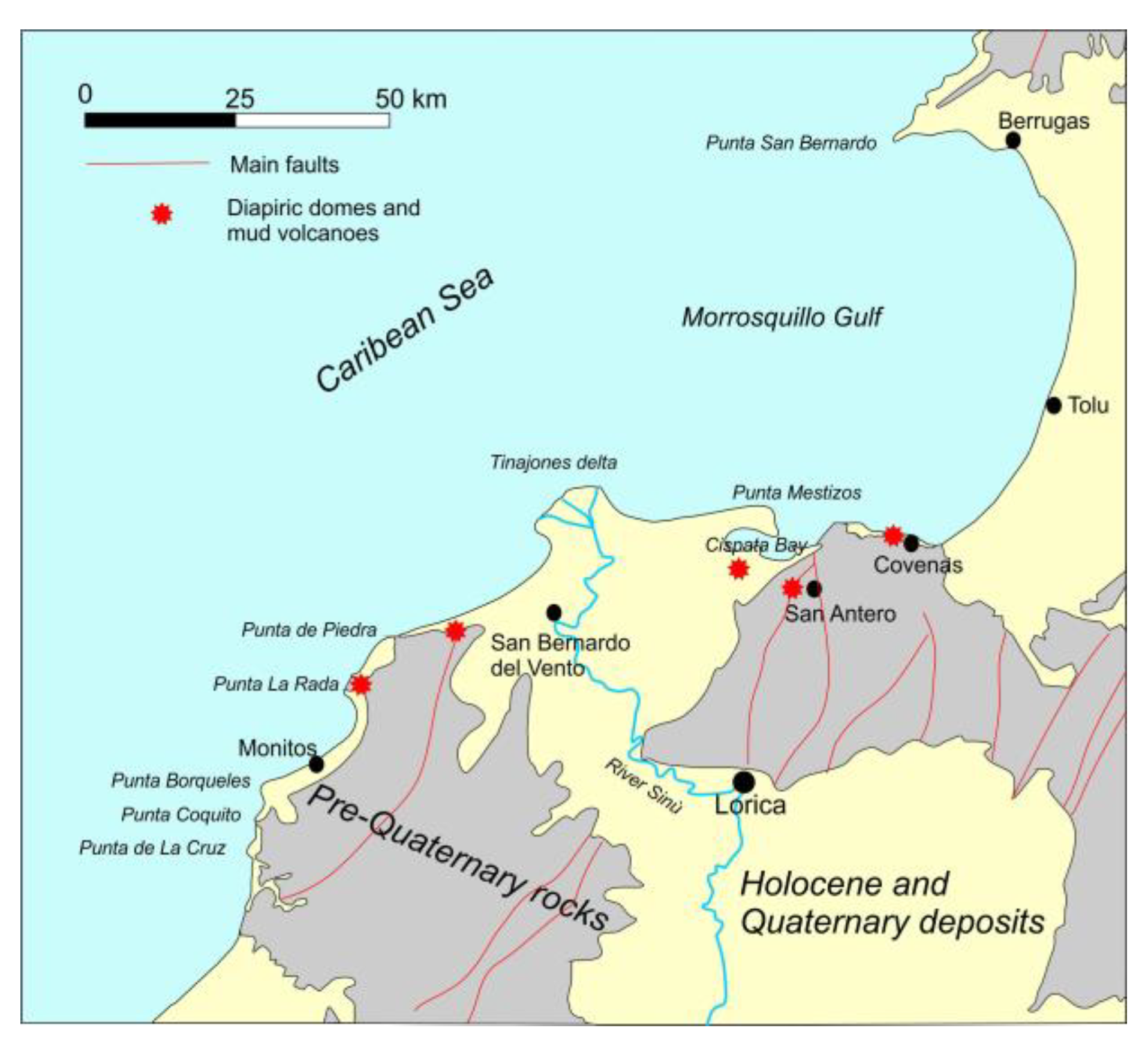
2. Study Area
3. Materials and Methods
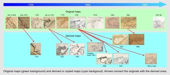
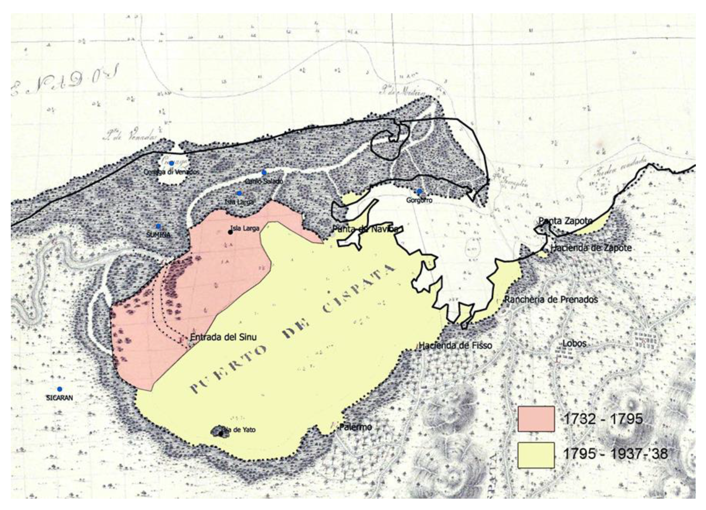
4. Geomorphological Evolution of the Area (Late 16th–Early 20th Century)
4.1. The 16th- and 17th-Century Maps
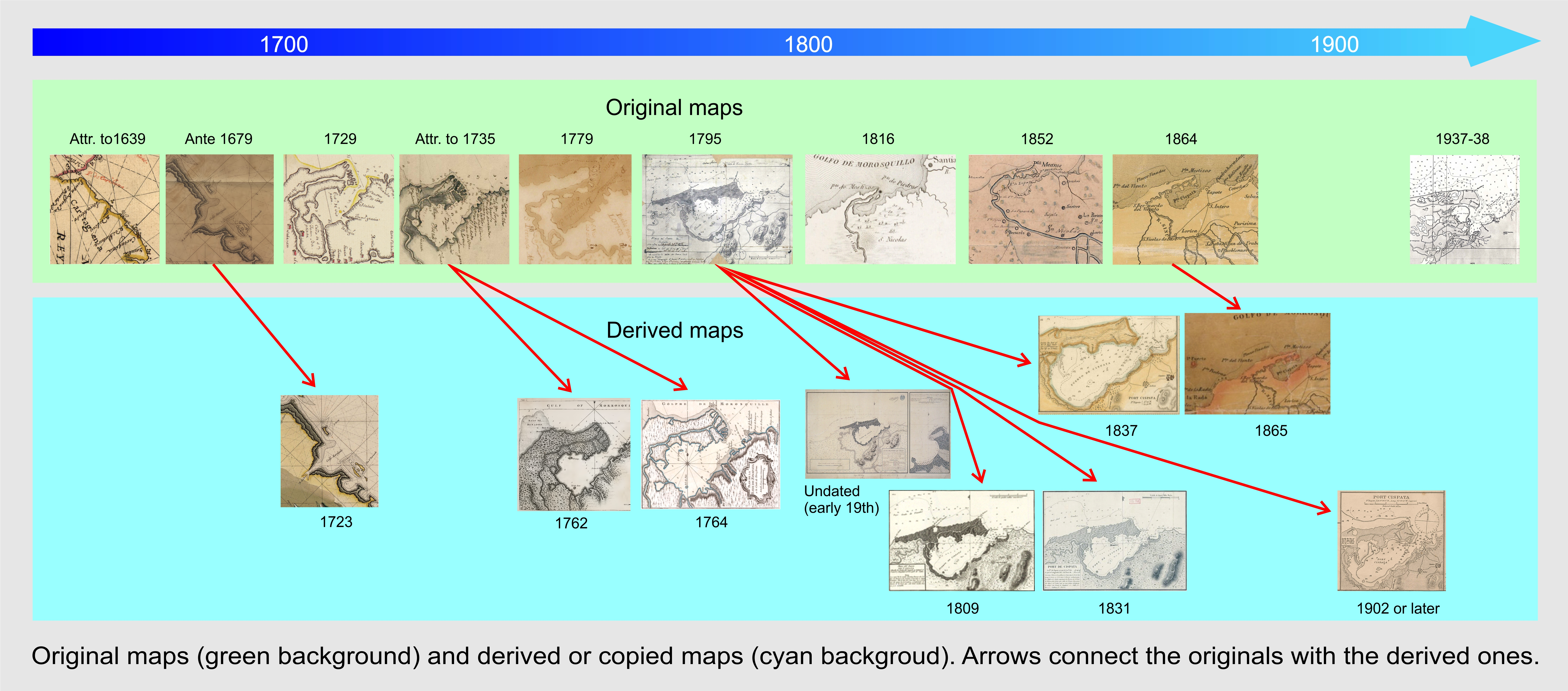
4.2. The 18th-Century Maps
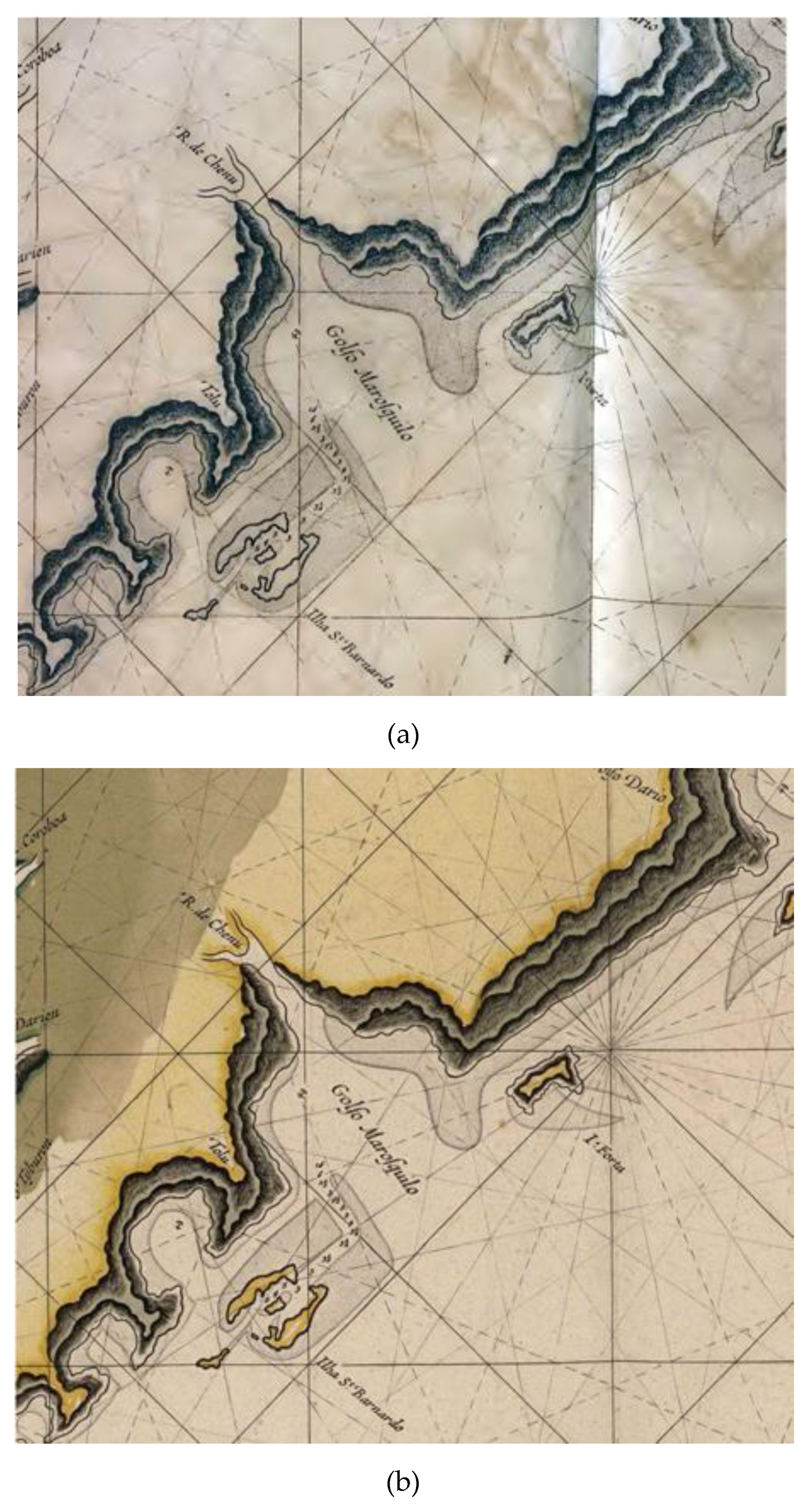
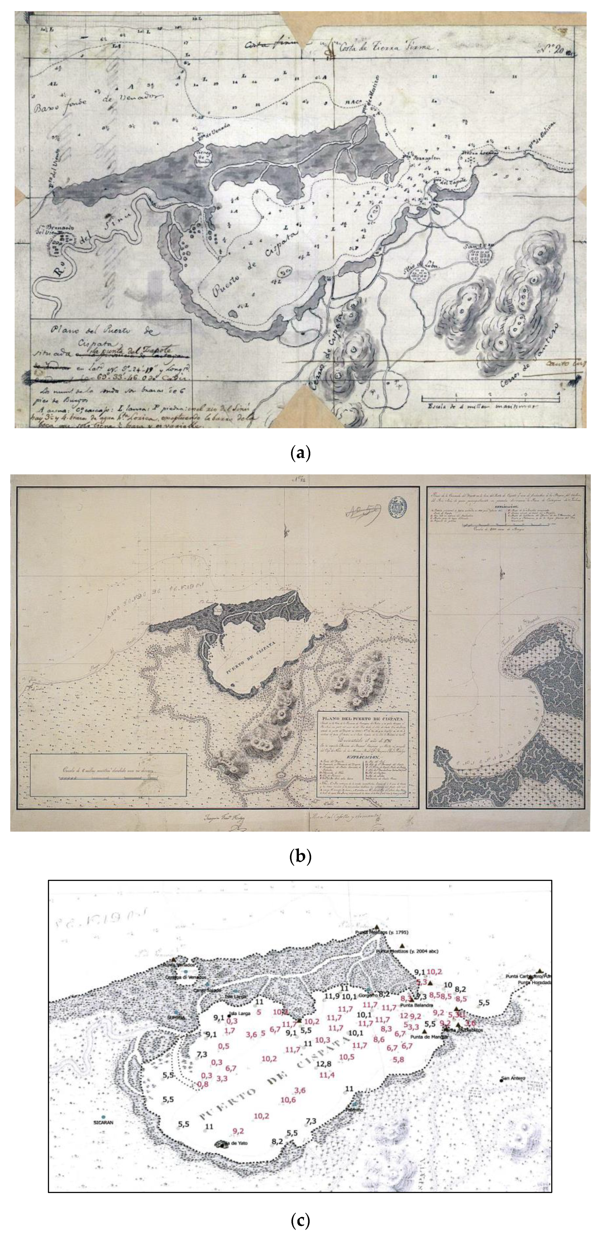
4.3. The 19th-Century Maps
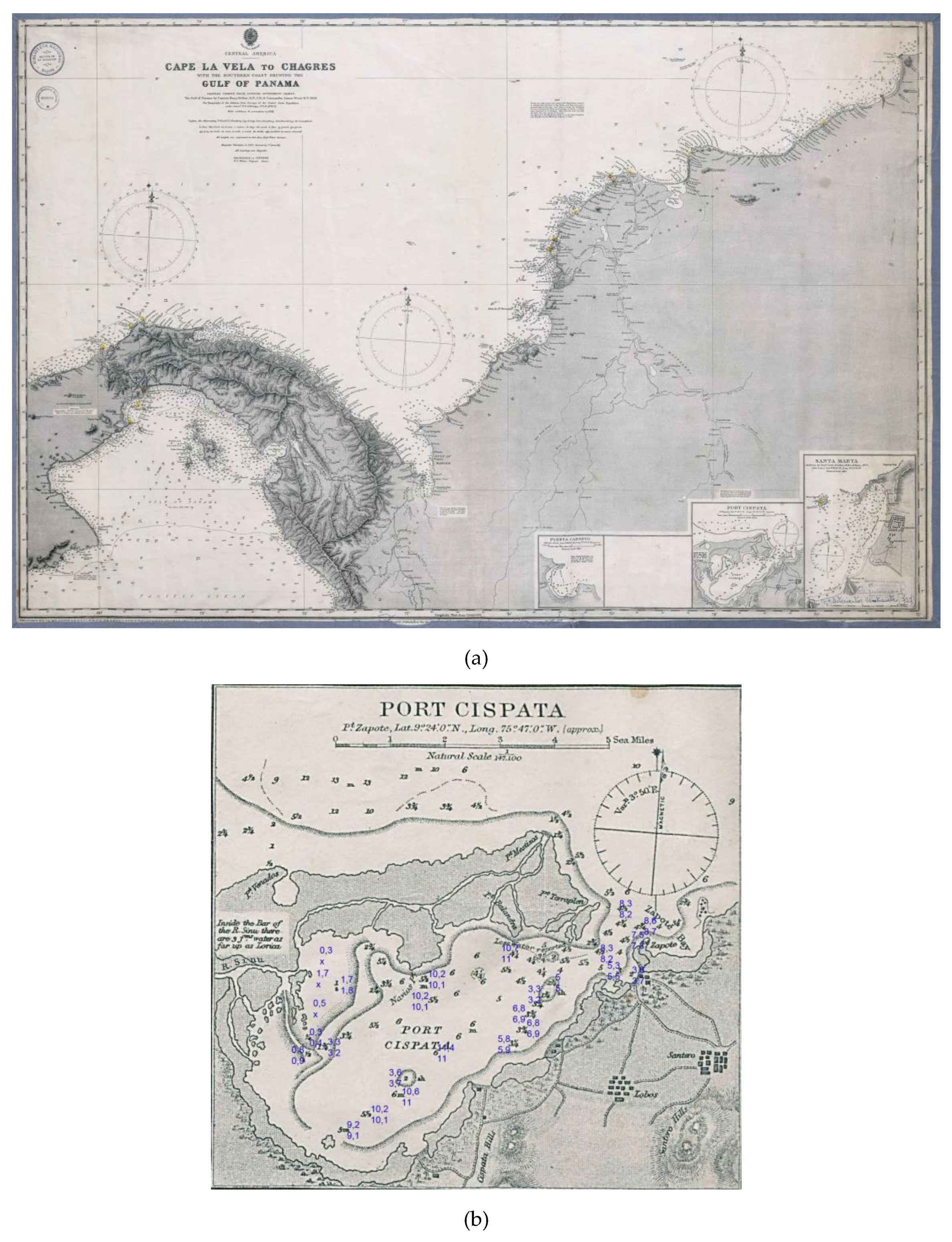
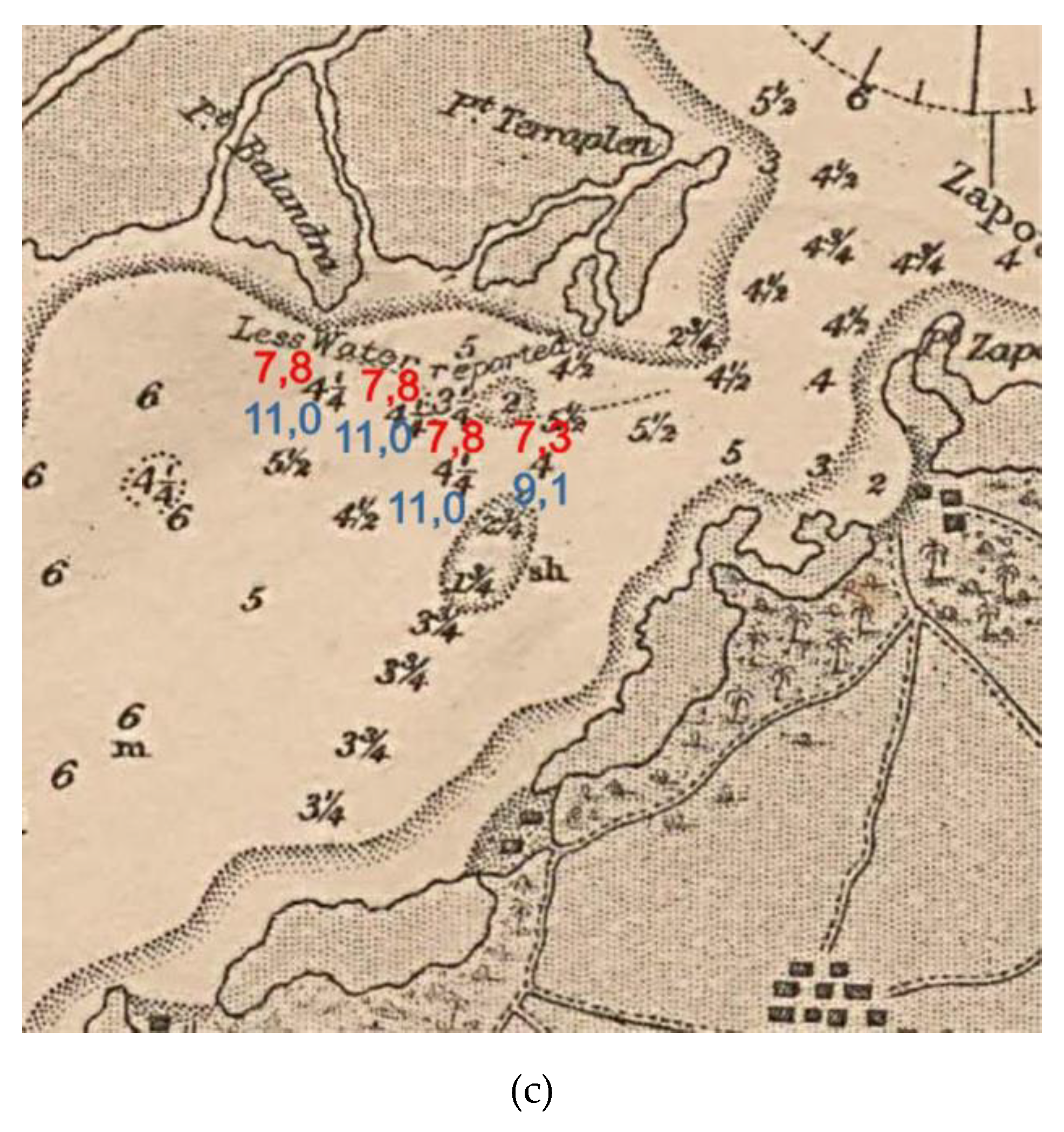
4.4. The Early 20th-Century Maps
5. Results
6. Conclusions
Author Contributions
Funding
Conflicts of Interest
References
- Campbell, T. Web Articles and Commentaries on Specific Topics in the History of Cartography. Available online: https://www.maphistory.info/webtexts.html (accessed on 28 December 2019).
- Rombai, L. Le problematiche relative all’uso della cartografia storica. In Bollettino Dell’associazione Italiana di Cartografia; EUT Edizioni Università Di Trieste: Trieste, Italy, 2010; Volume 138, pp. 69–89. [Google Scholar]
- Provansal, M.; Pichard, G.; Anthony, E.J. Geomorphic Changes in the Rhône Delta during the LIA: Input from the Analysis of Ancient Maps. In Sediment Fluxes in Coastal Areas; Maanan, M., Ed.; Springer: Berlin, Germany, 2016; pp. 47–72. [Google Scholar]
- Piccardi, M. Small, medium and large-scale maps in coastal studies. What happened to Arno’s mouth between the XIVth and the XIXth century. In E-Perimetron; Hellenic National Centre for Maps and Cartographic Heritage: Thessaloniki, Greece, 2014; Volume 9, pp. 176–195. Available online: http://www.e-perimetron.org/Vol9_4.htm (accessed on 28 December 2019).
- Piccardi, M.; Pranzini, E. Carte a Piccola, Grande e Grandissima Scala Negli Studi Sull’evoluzione del Litorale. Cosa è Successo a Bocca d’Arno tra il XVI e il XIX Secolo? In L’universo; Istituto Geografico Militare: Firenze, Italy, 2014; Volume 5, pp. 7–38. Available online: https://www.researchgate.net/publication/324645904_Carte_a_piccola_grande_e_grandissima_scala_negli_studi_sull’evoluzione_del_litorale_Cosa_e_successo_a_Bocca_d’Arno_tra_il_XVI_e_il_XIX_secolo_In_L’UNIVERSO_Anno_XCIV_2014_n_5 (accessed on 28 December 2019).
- Piccardi, M.; Pranzini, E. Le foci del Serchio e del Fiume Morto Nelle Restituzioni Cartografiche Pre-Geodetiche. In Studi Costieri; 2014; Volume 23, pp. 21–58. Available online: https://www.researchgate.net/publication/323581889_Le_foci_del_Serchio_e_del_Fiume_Morto_nelle_restituzioni_cartografiche_pre-geodetiche (accessed on 28 December 2019).
- Mestanza, C.; Piccardi, M.; Pranzini, E. Coastal Erosion Management at Callao (Peru) in the 17th and 18th Centuries: The First Groin Field in South America? Water 2018, 10, 891. Available online: https://www.researchgate.net/publication/326195246_Coastal_Erosion_Management_at_Callao_Peru_in_the_17th_and_18th_Centuries_The_First_Groin_Field_in_South_America (accessed on 28 December 2019). [CrossRef]
- Dunsterville, E. Admiralty Catalogue of Charts, Plans, Views, and Sailing Directions; George Edward Eire-William Spottiswode: London, UK, 1864; p. 197. Available online: https://archive.org/details/admiraltycatalo00rngoog/page/n10 (accessed on 28 December 2019).
- Lepore, F.; Piccardi, M.; Pranzini, E. Latitudine senza latitudine. Determinazioni astronomiche e carte per navigare dell’Europa tardo edieval: Le innovazioni di Francesco Beccari. Studi Costieri 2017, 27, 33–107. Available online: https://www.researchgate.net/publication/323581862_Latitudine_senza_latitudine_Determinazioni_astronomiche_e_carte_per_navigare_dell’Europa_tardo-medievale_le_innovazioni_di_Francesco_Beccari, (accessed on 28 December 2019).
- Schilder, G.; van Egmond, M. Cartography in the Low Countries during the Renaissance. In The History of Cartography; University of Chicago Press: Chicago, IL, USA, 2007; Volume 3, pp. 1383–1432. [Google Scholar]
- Arent, R. De Cust van Westindien Tußchen I. Cares en C. de Tÿburon. 1679. Available online: https://gallica.bnf.fr/ark:/12148/btv1b53121812s.r=btv1b53121812s?rk=21459;2 (accessed on 28 December 2019).
- Anonymous. Pas-kaarte Van de Zee Kusten van Carthagena Tierra Firma […]. In Le nouveau et Grand Illuminant Flambeau de la Mer. l.a Quatrieme Partie; Biblioteca Nacional De España: Amsterdam, The Netherlands, 1723; Available online: http://bdh.bne.es/bnesearch/detalle/bdh0000141049 (accessed on 28 December 2019).
- Kellett, H.; Wood, J. The Central America. Cape la Vela to Chagres with the Southern Coast Shewing the Gulf of Panama. Compiled Chiefly from Spanish Government Charts. The Gulf of Panama by Captain Henry Kellett, R.N., C.B. Commander James Wood, R.N. 1849. The Topography of the Isthmus from Surveys of the United States Expedition under Comm.r T.O.; Selfridge, U.S.N. 1870–1871. With Additions & Corrections to 1891; Archivo General de la Nacion, Bogota, Mapoteca 4, Mapa 727, Date Unreadable, 1902 or Later. Available online: https://repository.urosario.edu.co/bitstream/handle/10336/4087/mapotecacolombiana.pdf?sequence=1 (accessed on 28 December 2019).
- Serrano Suarez, B.E. The Sinù river delta on the Northwestern Caribbean coast of Colombia: Bay infilling associated with delta development. J. S. Am. Earth Sci. 2004, 16, 623–631. [Google Scholar] [CrossRef]
- Restrepo, J.C.; Ortiz, J.C.; Pierini, J.; Schrottke, K.; Maza, M.; Otero, L.; Aguirre, J. Freshwater discharge into the Caribbean Sea from the rivers of Northwestern South America (Colombia): Magnitude, variability and recent changes. J. Hydrol. 2014, 509, 266–281. [Google Scholar] [CrossRef]
- Restrepo, J.D.; López, S.A.; Restrepo, J.C. The Effects of Geomorphic controls on sediment yield in the Andes rivers of Colombia. Latin American. J. Sedimentol. Basin Anal. 2009, 16, 79–92. [Google Scholar]
- IDEAM. Instituto de Hidrología, Meteorología y Estudios Ambientales; Universidad Nacional de Colombia Morfodinámica, Población y Amenazas Naturales en el Litoral Caribe Colombiano: Valle del Sinú-Morrosquillo-canal del Dique; Santa Fe de Bogotá: Bogotà, Colombia, 1998.
- Vernette, G.; Mauffret, A.; Bobier, C.; Briceño, L.; Gayet, J. Mud diapirism, fan sedimentation and strike-slip faulting, Caribbean Colombian Margin. Tectonophysics 1990, 202, 335–349. [Google Scholar] [CrossRef]
- INGEOMINAS. Mapa Geològico de Colombia; Escala 1:1,000,000; Colombian Geological Survey: Bogotà, Colombia, 2007.
- INGEOMINAS. Geología de las planchas 43 San Antero—43 bis San Bernardo del Viento, Escala 1: 100,000. In Memoria Explicative; Colombian Geological Survey: Bogotà, Colombia, 2003. [Google Scholar]
- Correa, I.D.; Morton, R. The Caribbean Coast of Colombia. 2003. Available online: https://coastal.er.usgs.gov/coasts-colombia/ (accessed on 15 April 2018).
- Correa, I.D. Erosión litoral entre Arboletes y Punta San Bernardo, Costa Caribe colombiana. Boletín Geol. 2007, 29, 2. [Google Scholar]
- Carvajal, H. Mud Diapirism in the Central Colombian Caribbean Zone. In Landscapes and Landforms of Colombia. World Geomorphological Landscapes; Hermelin, M., Ed.; Springer: Berlin/Heidelberg, Germany, 2016; pp. 35–53. [Google Scholar]
- Vergara, Y.; Velasco, F.J. Atlas Completo de Geografía Colombiana; Imprenta Eléctrica, Biblioteca Nacional de Colombia: Bogotá, Colombia, 1906–1910.
- Blanco Barros, J.A. El general Francisco Javier Vergara y Velasco y Sus Obras; Academia Colombiana de Historia: Bogotá, Colombia, 2006; Available online: https/www.sogeocol.edu.co/documentos/fjvvelasco.pdf (accessed on 28 December 2019).
- Parsons, J.J. The Settlement of the Sinù Valley of Colombia. Geogr. Rev. 1952, 42, 67–86. [Google Scholar] [CrossRef]
- Robertson, K.; Chaparro, J. Evolucion historica del delta del rıo Sinù. In Cuadernos de Geografia: Revista Colombiana de Geografía; Universidad Nacional de Colombia: Bogotà, Colombia, 1998; Volume 7, pp. 70–86. Available online: https://revistas.unal.edu.co/index.php/rcg/article/view/70834 (accessed on 28 December 2019).
- Hébert, J.R. The 1562 Map of America by Diego Gutiérrez s.d. Available online: https://www.loc.gov/rr/hispanic/frontiers/gutierrz.html (accessed on 28 December 2019).
- Martínez García, P. Mapping the ‘New World’: Medieval Traditions of Othering. Cartografiando el “Nuevo Mundo”: Tradiciones Medievales de Otredad. In Vegueta Anuario de la Facultad de Geografía e Historia; 2018; Volume 18, pp. 119–131. Available online: https://accedacris.ulpgc.es/bitstream/10553/25201/1/0234500_00018_0006.pdf (accessed on 28 December 2019).
- Wytfliet, Cornelius, Castilia aurifera. In Descriptionis Ptolemaicæ Augmentum; The John Carter Brown Library: Louvain, Belgium, 1597; Available online: https://jcb.lunaimaging.com/luna/servlet/detail/JCBMAPS~1~1~3398~101640:%20Castilia-aurifera-cum-vicinis-provi (accessed on 28 December 2019).
- Gutiérrez’, D. Americae Sive Quartae Orbis Partis Nova Et exactissima Description; Library of Congress: Washington, DC, USA, 1562. Available online: https://www.loc.gov/resource/g3290.ct000342 (accessed on 28 December 2019).
- Herrera y Tordesillas, Antonio de. In Novus Orbis, Sive, Descriptio Indiae Occidentalis; Michaelem Colinium: Amsterdam, The Netherlands, 1622; Available online: https://archive.org/details/novusorbissivede00herr/page/n4 (accessed on 28 December 2019).
- Cuesta, D.M. Estudio Critico Antonio de Herrera y Tordesillas; Edición Digital: Fundación Ignacio Larramendi: Madrid, Spain, 2015; p. 57. Available online: http://www.larramendi.es/es/catalogo_imagenes/grupo.do?path=1023152 (accessed on 28 December 2019).
- Berthe, J.P. Juan Lopez De Velasco (Co. 1530–1598). Cronista Y Cosmógrafo Mayor Del Consejo De Indias: Su Personalidad Y Su Obra Geográfica. In Relaciones 75, Verano, Vol. XIX.; Escuela de altos Estudios en Ciencias Sociales: París, France, 1998; pp. 142–172. Available online: https://www.colmich.edu.mx/relaciones25/files/revistas/075/JeanPierreBerthesecTem.pdf (accessed on 28 December 2019).
- Herrera y Tordesillas, Antonio de. Descripcion del Audiencia del Nuevo Reino, Barry Lawrence Ruderman Antique Maps. 1601. Available online: https://www.raremaps.com/gallery/detail/0362gh/descripcion-del-audiencia-del-nuevo-reino-columbia-venezu-herrera-y-tordesillas (accessed on 28 December 2019).
- De Laet, J. De Groote Ende Kleyne Eylanden van West-Indien. In Nieuvve Wereldt, Ofte, Beschrijvinghe van West-Indien: Wt Veelderhande Schriften Ende Aen-Teeckeninghen van Verscheyden Natien. 1625. Available online: https://archive.org/details/nieuvvewereldtof00laetrich/page/n3 (accessed on 28 December 2019).
- Vingboons, J. De Eylanden en Vastelanden van Westindien, Library of Congress. 1639. Available online: http://hdl.loc.gov/loc.gmd/g3300.lh000029 (accessed on 28 December 2019).
- Campbell, T. A Critical Re-Examination of Portolan Charts with a Reassessment of Their Replication and Seaboard Function, 2011–2019. Available online: http://www.maphistory.info/portolan.html (accessed on 28 December 2019).
- Lepore, F.; Piccardi, M.; Pranzini, E. Costa e Arcipelago Toscano nel Kitab I Bahriye un Onfront Cartografico (Secoli XIII-XVII); Ghezzano: Pisa, Italy, 2011; p. 174. Available online: https://www.researchgate.net/profile/Marco_Piccardi2 (accessed on 28 December 2019).
- De Laet, J. Novvus Orbis Seu Descriptionis Indiae Occidentalis Libri XVII: Novis Tabulis Geographicis et Variis Animantium, Plantarum Fructumque Iconibus Illustrati, Elzeviros, Leida. 1633. Available online: https://archive.org/details/novusorbisseudes00laet/page/n6 (accessed on 28 December 2019).
- Pérez, D.A. Plano y Descripción de la Costa y Provincia de Cartagena de Yndias Desde Sta. Marta Hasta el Río del Senut y Ysla Tortuga Puestos Todos Sus Paraxes en Sus Verdaderas Latds. Y Longds. Segun el Eridian del Cuerbo; Library of Congress: Washington, DC, USA, 1729. Available online: https://www.loc.gov/resource/g5292c.lh000284/?r=0.48,0.041,0.257,0.097,0, (accessed on 28 December 2019).
- Het Geheugen (The Memory). Available online: https://geheugen.delpher.nl/en/geheugen/view?coll=ngvn&identifier=NESA01%3AK04-0210 (accessed on 28 December 2019).
- Jefferys, T. Gulf of Morrosquillo. Plan of Zisapata bay. In A Description of the Spanish Islands and Settlements on the Coast of the West Indies: Compiled from Authentic Memoirs, Revised by Gentlemen Who Have Resided Many Years in the Spanish Settlements: And Illustrated with Thirty-Two Maps and Plans, Chiefly from Original Drawings Taken from the Spaniards in the Last War; Faden and Jefferys, The Corner of Saint Martin: London, UK, 1762; Available online: https://archive.org/details/descriptionofspa00jeff/page/n8 (accessed on 28 December 2019).
- Galloway, W.E. Process framework for discriminating the morphologic and stratigraphic evolution of deltaic depositional systems. In Deltas. Models for Explorations; Broussad, M.L., Ed.; Huston Geological Society: Huston, TX, USA, 1975; pp. 87–96. [Google Scholar]
- Anonymous. Biblioteca Nacional De España. 1732. Available online: http://bdh-rd.bne.es/viewer.vm?id=0000143609 (accessed on 28 December 2019).
- Bellin, J.N. Plan de la Baye de Zisapata a la Coste de Terre Ferme, 1st ed.; Pranzini’s Private Collection: Córdoba, Colombia, 1764. [Google Scholar]
- De la Torre y Miranda Antonio. Plan Que Manifiesta las Costas de la Mar del Norte y Sur, y Terrens Que Intermedia Entre Los Rios Sinù, y Atrato Con Sus Canos, Quebradas, Ríos Que Desaguan en Ellos, y el Camino Que de Orden de Exmo. Sr. D. Manuel Antonio de Flores, Comendador de Lopera. 1779. Available online: https://www.raremaps.com/gallery/detail/34467hs/plan-que-manifiesta-las-costas-de-la-mar-del-norte-y-sur-y-de-la-torre-y-miranda (accessed on 28 December 2019).
- Anonymous. Carta de las Costas de Nueva Granada Comprendidas Entre la Punta de Las Marcas y Santa Marta; Biblioteca Nacional De España: Madrid, Spain, 1735; Available online: http://bdh-rd.bne.es/viewer.vm?id=0000143586= (accessed on 28 December 2019).
- Bertrand, J.; Van, K. Nieuwe en Zeer Naaukeurige Paskaart van de Kusten van West Indien Strekkende van rio Oronoque tot Beneede Cartagena Met alle de Caribische Eylande. 1726. Available online: https://gallica.bnf.fr/ark:/12148/btv1b53103244q.r=btv1b53103244q?rk=21459;2 (accessed on 28 December 2019).
- Cuervo, A.B. Colección De Documentos Inéditos Sobre La Geografìa y La Historia De Colombia [...]; Expedición Fidalgo, Imprenta de Vapor de Zalamea Hermanos: Bogotà, Colombia, 1891; Volume I, Available online: https://repository.javeriana.edu.co/handle/10554/83 (accessed on 28 December 2019).
- Martín-Merás, L. La Expedición Hidrográfica del Atlas de la América septentrional, 1792–1805. J. Lat. Am. Geogr. 2008, 7, 203–218. [Google Scholar] [CrossRef]
- Derrotero de las Islas Antillas, de las Costas de Tierra Firme y de las del Seno Mexicano […]; La Imprenta Real: Madrid, Spain, 1810; Available online: https://archive.org/details/derroterodelasi00spaigoog/page/n9 (accessed on 28 December 2019).
- Fidalgo Joaquín Franco. Costa de Tierra Firme, Plano del Puerto de Cispata; Biblioteca Virtual del Patrimonio Bibliográfico, Museo Naval, Colección: Madrid, Spain, 1795; Available online: https://bvpb.mcu.es/es/consulta/resultados_ocr.do?id=9192&forma=ficha&tipoResultados=BIB&posicion=2 (accessed on 28 December 2019).
- Derrotero de las Islas Antillas, de las Costas de Tierra Firme y de Las del Seno Mexicano […]; La Imprenta Nacional: Madrid, Spain, 1820; Available online: https://catalog.hathitrust.org/Record/011640551 (accessed on 20 December 2019).
- Fidalgo Joaquín Franco. Plano del seno de Cispata […] Levantado el año de 1795 por La segunda División de Bergants. Empresa y Alerta el mando del Capn. De Navío de la Marina Real Dn. Joaquín Franco. Fidalgo, Manuel del Castillo y Armenta. Insect dedicated to the nsenada de Zapote, Biblioteca Virtual del Patrimonio Bibliográfico. 1795. Available online: https://bvpb.mcu.es/es/consulta/resultados_ocr.do?id=9192&forma=ficha&tipoResultados=BIB&posicion=3 (accessed on 28 December 2019).
- Robertson, K. Avulsión, cambios de curso y delta del Río Sinù. In Revista CIAF, II Simposio Latinoamericano de Sensores Remotos; Ministerio de Obras Publicas y Transporte, Centro Interamericano de Fotointerpretacion: Bogotà, Colombia, 1987; pp. 237–249. [Google Scholar]
- Codazzi, B.A. Carta Jeográfica de los Estados Unidos de Colombia Antigua Nueva Granada; Biblioteca Nacional De España: Madrid, Spain, 1865; Available online: http://bdh.bne.es/bnesearch/detalle/2671251 (accessed on 28 December 2019).
- Heinrich Michaelis Ernst; von Humboldt Alexander; de Caldas Francisco José, Carte du Rio Grande de la Magdalena depuis le 4 de Latitude Jusqu’à son Embouchure Dressée d’après les Observations Astronomiques & des Mesures Barometriques par Alexandre de Humboldt, Gallica. 1816. Available online: https://gallica.bnf.fr/ark:/12148/btv1b8492825r.r=btv1b8492825r?rk=21459;2 (accessed on 28 December 2019).
- Humboldt, A.V.; Bonpland, A. Personal Narrative of Travels to the Equinoctial Regions of America during the Years 1799–1804; George Bell & Sons: London, UK, 1908; Volume 3, Available online: https://archive.org/details/personalnarrati00humbgoog/page/n5 (accessed on 28 December 2019).
- Dirección, d.T.H. Portulano de la America Setentrional: Dividido en Quatro Partes Construido en la Direccion de Trabajos Hidrograficos Edición; Biblioteca Virtual del Patrimonio Bibliográfico: Madrid, Spain, 1809; Available online: https://bvpb.mcu.es/es/consulta/registro.cmd?id=448106 (accessed on 28 December 2019).
- Nieto, M.; Muñoz, S.; Díaz-Piedrahita, S.; Arias, J. La obra Cartográfica de Francisco José de Caldas; Ediciones Uniandes, Academia Colombiana de Historia, Academia Colombiana de Ciencias Exactas Físicas y Naturales, Instituto Colombiano de Antropología e Historia ICANH: Bogotá, Colombia, 2006; Available online: https://www.researchgate.net/publication/262439511_Mauricio_Nieto_Olarte_La_obra_cartografica_de_Francisco_Jose_de_Caldas_Mauricio_Nieto_Olarte_Santiago_Munoz_Arbelaez_Santiago_Diaz-Piedrahita_Jorge_Arias_de_Greiff_Bogota_Universidad_de_los_Andes_Facu (accessed on 28 December 2019).
- Anonymous. Plano del Puerto de Cispata: Situada la Punta del Zapote en Longitud N 9 24′ 19” y Longitude 69 33′ 46” O. de Cadiz; Biblioteca Virtual del Patrimonio Bibliográfico, Cartoteca del Archivo General Militar de Madrid, Colección: Madrid, Spain, 1809; Available online: https://bvpb.mcu.es/es/consulta/resultados_ocr.do?id=9192&forma=ficha&tipoResultados=BIB&posicion=1 (accessed on 28 December 2019).
- Anonymous. Port de Cispata […], Gallica. 1831. Available online: https://gallica.bnf.fr/ark:/12148/btv1b531220481.r=btv1b531220481?rk=21459;2 (accessed on 28 December 2019).
- Anonymous. West Indies: Sheet X from de Cabo la Vela to Cayos Ratones Port Cispata, Red Culural del Banco en la República de Colombia. 1837. Available online: http://babel.banrepcultural.org/cdm/ref/collection/p17054coll13/id/516 (accessed on 28 December 2019).
- Dawson, L.S. Memoirs of Hydrography: Including Brief Biographies of the Principal Officers Who Have Served in H.M. Naval Surveying Service between the years 1750 and 1885; Keay, J., Ed.; Cornmarket P: London, UK, 1883; p. 156. Available online: https://archive.org/details/cihm_68425 (accessed on 28 December 2019).
- Seeman, B. Narrative of the Voyage of H.M.S. Herald during the Years 1845–1851, under the Command of Captain Henry Kellett, R.N: Being a Circumnavigation of the Globe, and Three Cruizes to the Arctic Regions in Search of Sir John Franklin; Reeve And Co: London, UK, 1853; Available online: https://catalog.hathitrust.org/Record/001271587 (accessed on 28 December 2019).
- De León Ponce, M.; Paz, M.M. Carta Corográfica del Estado de Bolívar, Construida con Los Datos de la Comisión Corográfica I de Orden del Gobierno Jeneral, Red Culural del Banco en la República de Colombia. 1864. Available online: http://babel.banrepcultural.org/digital/collection/p17054coll13/id/30/rec/2 (accessed on 28 December 2019).
- Routier des îles, A. Des Côtes de Terre-Ferme et de Celles du Golfe du Mexique: Rédigé à la Direction des Travaux Hydrographiques de Madrid, Pour l’intelligence et l’usage des Cartes qu’elle a Publiées […], 3rd ed.; Imprimerie Royal: Paris, France, 1829; Available online: https://issuu.com/scduag/docs/gad11035.1/90 (accessed on 28 December 2019).
- Nepomuceno de Santamaria. Mapa de la Provincia de Cartajena; Biblioteca Nacional de Colombia: Bogotá, Colombia, 1852. Available online: https://catalogoenlinea.bibliotecanacional.gov.co/custom/web/content/mapoteca/fmapoteca_225_fagn_20/fmapoteca_225_fagn_20.htm (accessed on 28 December 2019).
- Vergara y Velasco, F.J. Nueva Geografía de Colombia; Imprenta de Vapor: Bogotá, Colombia, 1901–1902; Available online: https://archive.org/details/nuevageografiad00velagoog/page/n7 (accessed on 28 December 2019).
- Murillo, L.M. Francisco Javier Vergara Y Velasco in Boletin de la Sociedad Geografica de Colombia, 68, XVIII. 1960. Available online: https://www.sogeocol.edu.co/documentos/068_Jav_fra_ver_velas_02.pdf (accessed on 28 February 2020).
- Nokomis and Bushnell Map, Defense Mapping Agency Hydrographic/Topographic Center. In Golfo de Morrosquillo. Puerto Coveñas and Bahıa de Cispata. From a survey by U.S.S., 17th ed.; Bushnell in 1938 in collaboration with the Instituto Geografico Militar de Colombia: Bogota, Colombia, 1994.
- Cunningham, G.R.B. Cartagena and the Banks of the Sinù; Heineman: London, UK, 1920; Available online: https://archive.org/details/cartagenabanksof00cunnuoft/page/n10 (accessed on 28 December 2019).
- Ruiz-Ochoa, M.; Bernal, G.; Polanía, J. Influencia del Río Sinú y el mar caribe en el sistema lagunar de Cispatá. Boletín Investig. Mar. Costeras 2008, 37, 31–51. [Google Scholar] [CrossRef]
- Reclus, J.É. Colombia; Papeleria de Samper Matiz: Bogotá, Colombia, 1893; p. 531. Available online: http://bdh-rd.bne.es/viewer.vm?id=0000111908&page=1 (accessed on 28 December 2019).
- Restrepo, J.C.; Ojeda, B.G.Y.; Correa, I.D. Geomorfología de la plataforma somera del Departamento de Córdoba, Costa Caribe Colombiana. Bol. Cienc. Tierra Boletín Cienc. Tierra 2007, 20, 39–52. [Google Scholar]


© 2020 by the authors. Licensee MDPI, Basel, Switzerland. This article is an open access article distributed under the terms and conditions of the Creative Commons Attribution (CC BY) license (http://creativecommons.org/licenses/by/4.0/).
Share and Cite
Piccardi, M.; Correa, I.D.; Pranzini, E. Cispatá Bay and Mestizos Evolution as Reconstructed from Old Documents and Maps (16th–20th Century). J. Mar. Sci. Eng. 2020, 8, 669. https://doi.org/10.3390/jmse8090669
Piccardi M, Correa ID, Pranzini E. Cispatá Bay and Mestizos Evolution as Reconstructed from Old Documents and Maps (16th–20th Century). Journal of Marine Science and Engineering. 2020; 8(9):669. https://doi.org/10.3390/jmse8090669
Chicago/Turabian StylePiccardi, Marco, Ivan D. Correa, and Enzo Pranzini. 2020. "Cispatá Bay and Mestizos Evolution as Reconstructed from Old Documents and Maps (16th–20th Century)" Journal of Marine Science and Engineering 8, no. 9: 669. https://doi.org/10.3390/jmse8090669
APA StylePiccardi, M., Correa, I. D., & Pranzini, E. (2020). Cispatá Bay and Mestizos Evolution as Reconstructed from Old Documents and Maps (16th–20th Century). Journal of Marine Science and Engineering, 8(9), 669. https://doi.org/10.3390/jmse8090669