Article

Geochemical Characteristics and Hydrocarbon Accumulation Model of Natural Gas in the Third Member of the Oligocene Lingshui Formation in the Baodao Sag, Qiongdongnan Basin, South China Sea

1
School of Geosciences, Yangtze University, Wuhan 430100, China
2
Hubei Key Laboratory of Complex Shale Oil and Gas Geology and Development in Southern China, Wuhan 430100, China
3
CNOOC China Limited, Hainan Branch, Haikou 570312, China
*
Author to whom correspondence should be addressed.
J. Mar. Sci. Eng. 2025, 13(4), 774; https://doi.org/10.3390/jmse13040774
Submission received: 17 March 2025 / Revised: 3 April 2025 / Accepted: 9 April 2025 / Published: 14 April 2025

Abstract

:
The deep-water area of the Qiongdongnan basin is currently a hot topic for exploration. The discovery of gas fields in the Baodao sag confirms its abundant oil and gas resources and potential, making it of significant economic and strategic importance. The complexity of sedimentary structural evolution within the Baodao sag makes the process of oil and gas accumulation in the area extremely complex, and the law of natural gas enrichment is difficult to grasp, resulting in unclear exploration directions. Therefore, this study focuses on the third member of the Lingshui Formation in the Paleogene of the Baodao sag. Based on the abundant thin section, scanning electron microscopy, 3D seismic and geochemical analysis data in the area, through analyzing the density of natural gas, the proportion of hydrocarbon and non-hydrocarbon components, the dryness coefficient carbon, and the isotopic characteristics, combined with the deep natural gas genesis discrimination chart, the types and genesis types of natural gas and organic matter in the sag are clarified. In addition, combined with the package and BasinMod 2009 software, the filling period and reservoir-filling process were clarified and restored. At the same time, the reservoir formation characteristics of the different fault-step zones inside the sag were dissected and the primary and secondary migration of natural gas were analyzed in order to clarify the types and characteristics of different fault-step zone transport systems. Finally, the research findings indicate that there are two reservoir formation modes developed within the depression, as follows: “multiple hydrocarbon generation and control sources—continuous vertical control of large faults—lateral sand body convergence (T + Z-type transport)—multiple cap layer closure” and “mixed-source hydrocarbon supply—continuous vertical control of large faults—short lateral sand body convergence (Z-type transport)—multiple cap layer closure”, providing an important basis for the next exploration of the basin.

1. Introduction

Nowadays, oil and gas resources in deep water have become a global exploration hotspot [1,2,3], with the deep-water area of the South China Sea accounting for 60% [4]; moreover, the submarine fans and canyon channels developed in deep-water areas are advantageous reservoirs [5,6,7,8,9,10,11]. The deep-water areas of Qiongdongnan Basin have sparked an exploration boom due to their enormous sedimentation and natural gas potential [12]. The Qiongdongnan basin, located in the northwest of the South China Sea, is a Cenozoic sedimentary basin with abundant oil and gas reserves and significant exploration value [5,13,14]. Multiple large- and medium-sized gas fields have been discovered in the west of the basin, such as the large gas field of Y13 and the large-to-medium gas fields of L17 and L18 [15]. Among them, the Baodao sag is a large, hydrocarbon-rich sag [14,16,17]. With the development of exploration technology and the continuous improvement of seismic data, a deep-water oil and gas field—the BD21-1 large gas field—was discovered in the northern fault-step zone of the Baodao sag in 2022 [16,17], which has promoted a new landscape for Paleogene oil and gas exploration in the area. A series of studies on the Baodao sag in the Qiongdongnan Basin have been conducted by various methods, such as those using seismic, logging, core and thin section, and geochemical data [11,18,19,20,21,22,23], clarifying structural evolution characteristics, sedimentary characteristics, sedimentary models, reservoir differential evolution characteristics, and natural gas genetic types in the deep-water area. Based on this, research on the structural control of reservoirs, such as the structural control of hydrocarbon sources, the structural transformation zones controlling sand, and the transportation system frameworks controlling natural gas enrichment, has been conducted. These studies have been used to further investigate the main controlling factors and accumulation models of natural gas. According to the current mining situation, the YL1-6 block in the southern fault zone and the BD21-1 block in the northern fault zone have similar conditions, as follows: being adjacent to the development of depression faults, having similar target reservoir cap combinations, having well-configured transport systems, and having developed structural ridges pointing towards structural high points. The complexity of sedimentary structural evolution has made the process of oil and gas accumulation in the region extremely complex, making it difficult to grasp the laws of natural gas enrichment. The research on the overall natural gas differential reservoir formation model in the north–south fault terraces of the Baodao sag in the Qiongdongnan basin is weak. Therefore, based on previous research, this article has conducted a detailed analysis of drilling data in the study area. The structural sedimentary evolution characteristics, the oil and gas sources and filling periods, the geometric morphology and activity of fault transport systems, the differential migration, and the accumulation characteristics of natural gas were analyzed, combined with an analysis of laboratory data in the study area. This series of studies elucidates the characteristics of natural gas enrichment, clarifies the laws and pathways of oil and gas migration and accumulation, and constructs a reservoir formation model for the Baodao sag in order to provide the latest research information for the exploration of similar basins in the future.

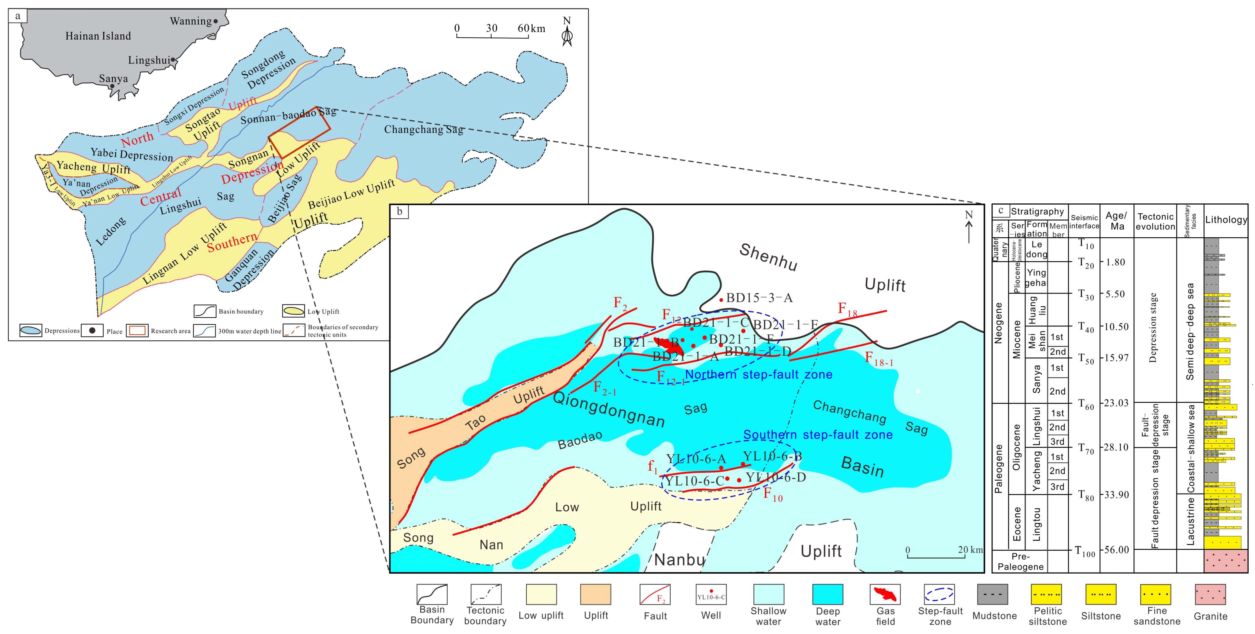
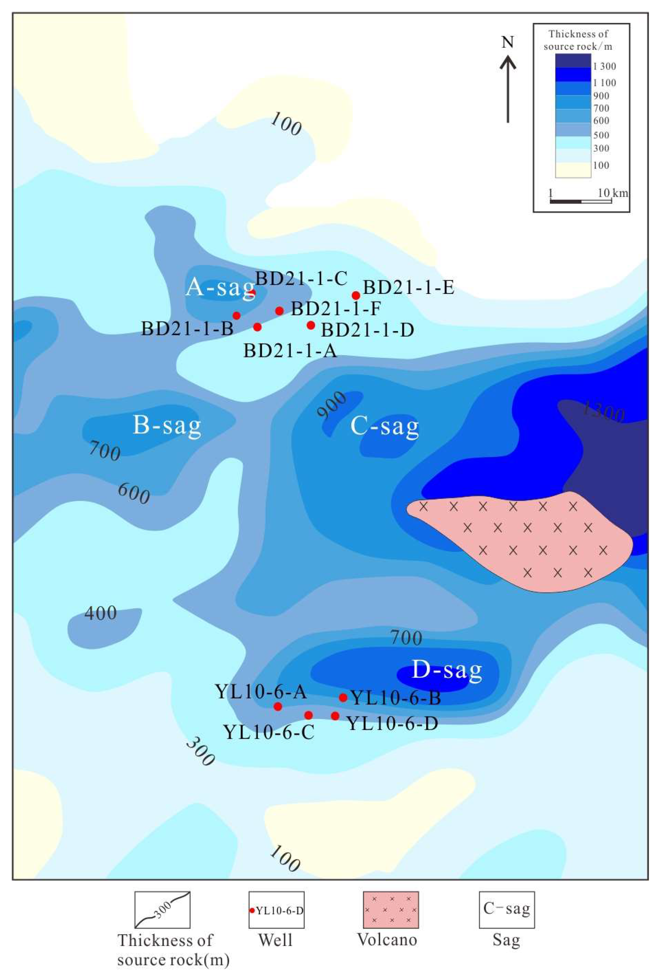
2. Geological Background

The Baodao sag, located in the north of the Qiongdongnan Basin, is a passive continental margin extensional basin characterized by a graben feature with north–south double faults [18] (Figure 1a,b). The Cenozoic strata deposited in the Baodao sag from bottom to top are the Lingtou Formation (E2l) (T100–T80) of the Eocene; the Yacheng Formation (E3y) (T80–T70) and Lingshui Formation (E3l) (T70–T60) of the Oligocene; the Sanya Formation (N1s) (T60–T50), Meishan Formation (N1m) (T50–T40), and Huangliu Formation (N1h) (T40–T30) of the Miocene; the Yinggehai Formation (N1y) (T30–T20) of the Upper Miocene; and the Ledong Formation (T20–T10) of the Holocene Neogene (Figure 1b) [24]. The semi-enclosed marine mudstone and coal-bearing source rock layers of the Yacheng Formation are the main source rocks in the study area, while the lacustrine mudstone of the Lingtou Formation of the Eocene is a potential source rock [25,26,27].
Since the Cenozoic era, the Qiongdongnan sag has gone through three stages of tectonic evolution, as follows: the rift stage (T100–T70), the rift–sag transition stage (T70–T60), and the depression stage (T60–present) [28,29], exhibiting the characteristics of faulting in the lower part and sagging in the upper part [30,31,32]. During the rift stage, the Indian Plate advanced northward and collided with the Eurasian Plate, while the Pacific Plate subducted northwestward [33,34]. The Lingtou Formation deposited during this period is mainly lacustrine sediments. The Yacheng Formation is dominated by shore–shallow marine sediments, with upper lithologies consisting of thick layers of dark gray mudstone interbedded with thin layers of yellow, muddy siltstone and fine sandstone, and lower lithologies of yellow, fine sandstone interbedded with thin layers of dark gray mudstone. During the rift–sag transition stage, the Indian Plate continued to advance northward, leading to a full collision between the Indian and Eurasian Plates. The Lingshui Formation deposited during this period is shore–shallow marine sediments, featuring large-scale delta sand bodies with lithologies of thick layers of yellow, muddy siltstone interbedded with varying thicknesses of gray mudstone, which serves as an important reservoir in the Baodao sag. In the late Oligocene, due to the South China sea spreading, the basin expanded north–south, the South China Sea southern margin block began to drift away from the South China continent and move southward, and the eastern part of the basin rapidly deepened. Since the depression stage, the intensity of regional tectonic movements has weakened, the intensity of plate collisions has decreased, and the subduction speed of the Pacific Plate toward the Eurasian Plate has slowed down [31,32,33,34,35,36], with the basin dominated by semi-deep to deep-sea sediments.

3. Materials and Methods

3.1. Samples

Analysis and laboratory data were collected on different strata in different structural zones, including 8 wells in the northern fault zone and 4 wells in the southern fault zone. A total of 87 natural gas component samples and 13 natural gas carbon isotope samples were collected. All test data were tested in the experimental center of the Hainan Branch of the China National Offshore Oil Corporation (CNOOC). For specific experimental procedures, instrument parameters, and standard sample information, please refer to reference [37]. The location of the well mentioned in this article is shown in Figure 1b.

3.2. Analytical Methods

By analyzing the density of natural gas, the proportion of hydrocarbon and non-hydrocarbon components, and the dryness coefficient, the types of natural gas in the Baodao sag can be clarified. By analyzing the carbon isotope characteristics of different natural gases, we can determine the type of organic matter; moreover, combined with the deep natural gas genesis discrimination chart, the final type of natural gas genesis was determined. Subsequently, by observing the color of the package, analyzing the filling period, and using the BasinMod 2009 simulation software, the reservoir-filling process was restored. The hydrocarbon generation potential within the sag was determined based on the thickness of the source rock and the TOC content. In addition, combined with the characteristics of reservoirs and tectonic activity in the source rock layers, the primary and secondary migration of natural gas was analyzed, and the types and characteristics of different fault-step belt transport systems were clarified. At the same time, the natural-gas-filling process, through the inclusion, can be analyzed. Based on all of the above studies, the natural gas accumulation process and model in the north–south fault-step zones of the Baodao sag were ultimately summarized and concluded.

4. Basic Conditions and Genesis of Natural Gas of the E3l Member in the Baodao Sag

4.1. Geochemical Characteristics of Natural Gas

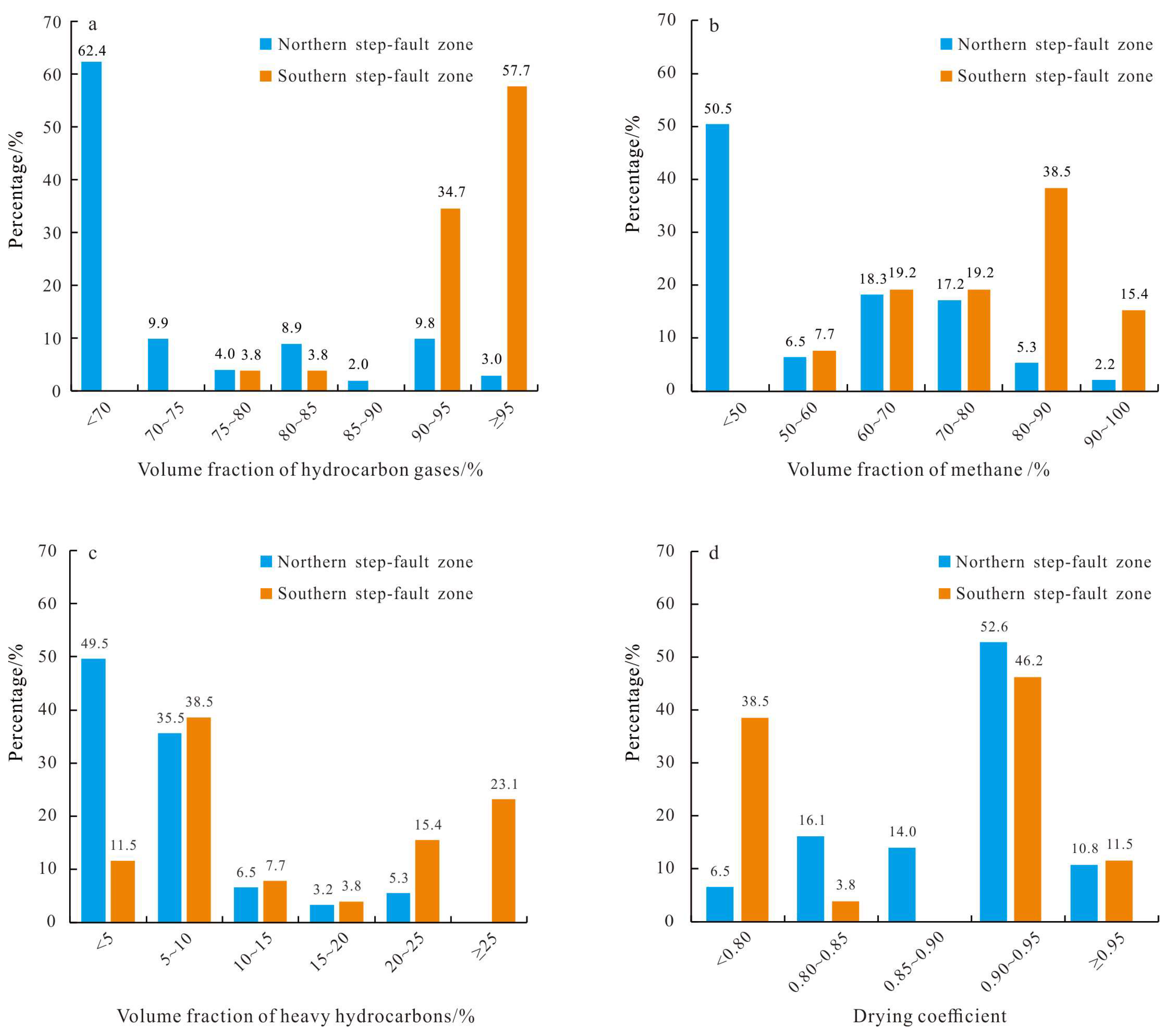
4.1.1. Characteristics of Natural Gas Components

The average densities of natural gas in the Paleogene of the northern and southern fault-step zones of the Baodao sag are 0.872 kg/m3 and 0.762 kg/m3, respectively, showing a gradual decrease in relative density from north to south. In the northern fault-step zone, the hydrocarbon gas volume fraction in natural gas is generally less than 70% (Figure 2a), with methane (CH4) volume fractions mainly ranging from 27.28% to 72.54% (Figure 2b). The heavy hydrocarbon (C2+) volume fraction is small, typically below 10% (Figure 2c), and over 60% of the samples have a dryness coefficient greater than 0.90 (Figure 2d), indicating a predominance of high-maturity dry gas. The volume fraction of CH4 in the northern fault zone is small, but the drying coefficient is high, which is due to the high volume fraction of the non-hydrocarbon gases. The volume fraction of the hydrocarbon gases in the southern fault zone is absolutely dominant, mainly concentrated between 90.47% and 99.17% (Figure 2a), and the CH4 volume fractions are high, ranging from 72.89% to 90.00% (Figure 2b). The volume fraction of the C2+ component is significantly higher than that of the northern fault zone (Figure 2c). The natural gas dryness coefficients are mainly distributed in two intervals, as follows: less than 0.80 and between 0.90 and 0.95, indicating a mixture of dry and wet gases in the southern fault-step zone (Figure 2d).
Non-hydrocarbon gases in the deep natural gas reservoirs of the target layer are mainly CO2 and N2 (Table 1), and the volume fractions of CO2 range from 0.71% to 58.81%, with a concentration between 2.00% and 30.00%. The high-CO2 area appears near F12 in the northern fault terrace zone, such as in Well BD21-1-B at 4268.5 m (volume fraction of 28.99%) and Well BD21-1-C at 4218.5 m (48.83%). The high CO2 volume fractions are attributed to the long-term activity of the F12 fault, which extends into the basement. Mantle-derived CO2 migrates upwards along this fault, resulting in generally higher CO2 volumes in the affected area. Well BD15-3-A in the Shenhu uplift, located at the periphery of the study area, reveals a CO2 volume fraction as high as 97.39%. The volume fractions of CO2 in the southern fault-step zone range from 0.71% to 7.26%, with a concentration between 1.00% and 3.00%. The volume fractions of N2 in the northern fault-step zone range from 0.06% to 20.50%. In summary, non-hydrocarbon gas volumes are significantly higher in the northern fault-step zone than in the southern fault-step zone.

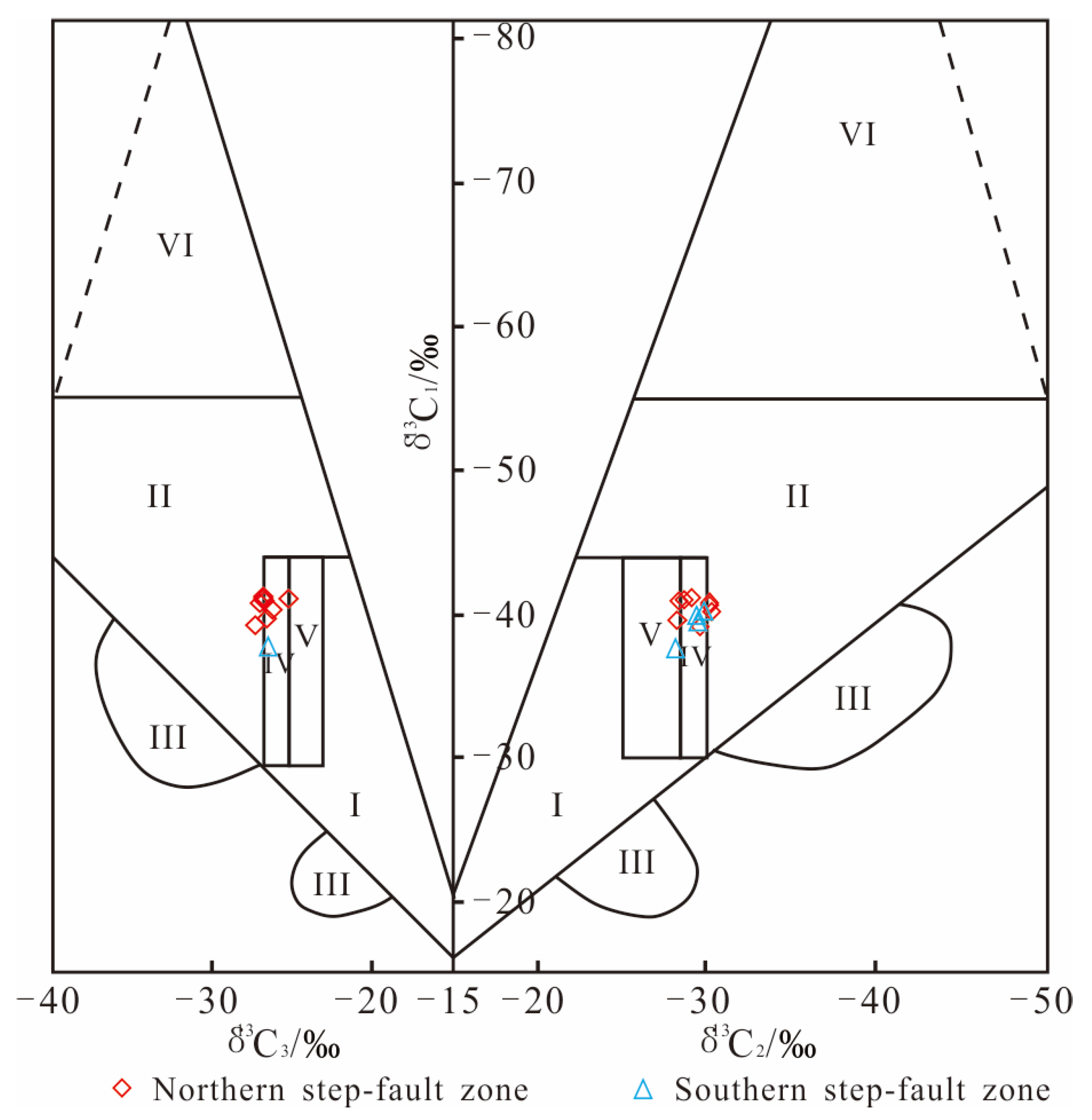
4.1.2. Characteristics of Carbon Isotopes in Natural Gas

The methane carbon isotope (δ13C1) values in the study area range from −41.1‰ to −37.45‰ (Table 1), with an average of −39.97‰. In the northern fault-step zone, the minimum value of δ13C1 was found in Well BD21-1-F, and the maximum value in Well BD21-1-B. Compared to the northern fault-step zone, the southern fault-step zone has higher δ13C1 values for natural gas, with an average of −39.14‰. The ethane carbon isotope (δ13C2) values range from −30.42‰ to −28.18‰, with an average of −29.4‰, and the minimum value was found in Well BD21-1-B in the northern fault-step zone. The averages for the northern and southern fault-step zones are −29.48‰ and −29.24‰, respectively. The propane carbon isotope (δ13C3) values show little variation, ranging from −27.62‰ to −25.82‰, with an average of −26.92‰. The butane carbon isotope (δ13C4) values vary between −26.39‰ and −24.96‰, with an average of −25.71‰. The carbon isotope values of deep natural gas in the north and south fault-step zones of the Baodao sag are overall low and exhibit the characteristic trend of δ13C1 < δ13C2 < δ13C3 < δ13C4. There are slight differences in the carbon isotopes between the north and south fault-step zones, with heavier carbon isotopes being found in the natural gas of the southern fault-step zone. The carbon isotope characteristics of natural gas in both zones indicate contributions from sapropelic organic matter [38].

4.2. Genesis of Natural Gas

The analysis of the carbon isotope composition of natural gas in the study area reveals that the δ13C1 values of deep natural gas in the Paleogene are less than −30.0‰, confirming that the natural gas in the study area is typically of organic origin [39,40]. Dai Jinxing et al. [39] concluded that the δ13C2 values of coal-derived gas are generally higher than −28.0‰, while the δ13C2 values of oil-type gas are typically lower than −28.5‰. When the δ13C2 values fall between −28.5‰ and −28.0‰, it indicates a coexistence of both gas types, with the coal-derived gas being dominant. When plotting the values of δ13C1, δ13C2, and δ13C3 from the third member of the Lingshui Formation in the study area into a genetic model of natural gas [41] (Figure 3), the carbon isotopic values primarily cluster in the coal-derived gas and oil-type gas zones. This indicates that the natural gas in the study area exhibits distinct mixed-source accumulation characteristics.

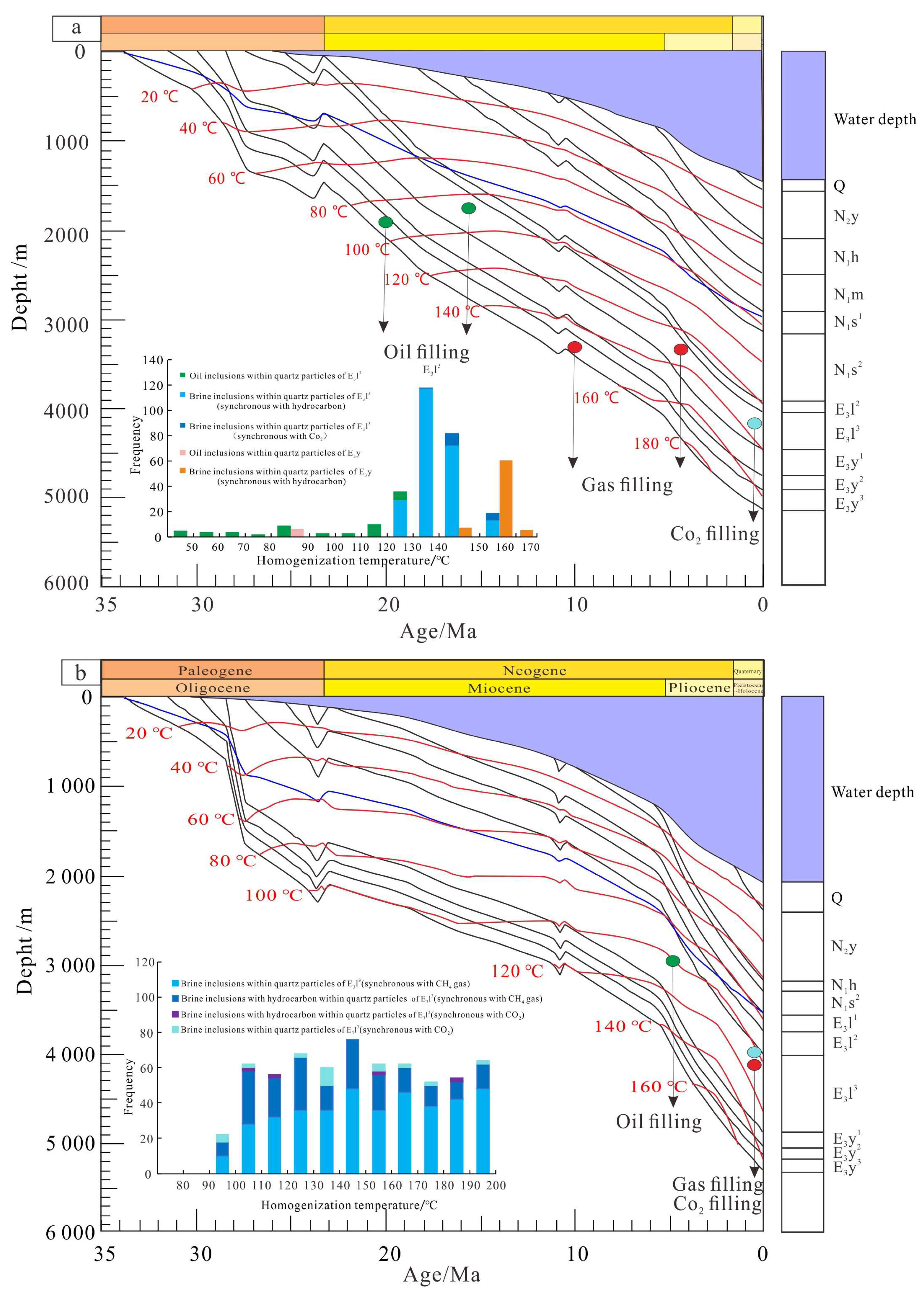
5. Charging Time of Natural Gas in the E3l3 Member of the Baodao Sag

Previous studies have shown that the BD21-1 gas field contains yellow, green, and blue-white fluid inclusions, indicating multiple stages of hydrocarbon charging [17,42]. In the E3l3 reservoir of Well BD21-1-A, located in the northern fault terrace, three types of inclusions were identified, as follows: oil inclusions with homogenization temperatures ranging from 80 to 100 °C, brine inclusions in hydrocarbon with homogenization temperatures peaking at 130 to 150 °C, and CO2-bearing brine inclusions with homogenization temperatures ranging from 140 to 160 °C (Figure 4a). In the Yacheng Formation reservoir, two types of inclusions were identified, as follows: oil inclusions with homogenization temperatures of 80 to 90 °C and brine inclusions in hydrocarbon with homogenization temperatures peaking at 150 to 160 °C (Figure 4a). Combined with the burial history of Well BD21-1-A (Figure 4a), it is believed that the reservoir of the E3l3 underwent three stages of hydrocarbon charging, as follows: oil charging during the Miocene (16.0 to 8.0 Ma), high-maturity hydrocarbon gas charging during the Miocene (5.0 Ma), and current high-maturity hydrocarbon gas charging accompanied by mantle-derived CO2. The reservoir of E3y underwent two stages of hydrocarbon charging, as follows: oil charging during the Miocene (20.0 to 19.0 Ma) and high-maturity hydrocarbon gas charging from the Miocene (10.0 Ma) to the present.
In the southern step-fault zone, the E3l3 reservoir of Well YL10-6-D contains quartz-grain-hosted oil inclusions with blue fluorescence, CH4 gas inclusions, and CO2-bearing brine inclusions. A contemporaneous saline fluid package with blue, fluorescent oil was not detected. Based on the homogenization temperature data of the fluid inclusions, the histogram of fluid inclusions in the E3l3 shows that the temperature of the water inclusions during the same period as the CO2 inclusions ranges from 97.9 to 193.1 °C, and the uniform temperature of its main peak ranges from 132.3 to 139.3 °C (Figure 4b). The homogenization temperatures of the brine inclusions contemporaneous with the CH4 gas inclusions have a wide distribution range, ranging from 92.3 to 195.4 °C, with a peak temperature between 140.2 and 149.6 °C. At least two stages of charging exist in the E3l3 of Well YL10-6-D, including natural gas charging and CO2 charging. The peak homogenization temperatures are significantly higher than the stratigraphic temperatures during the geological history. CO2, as an acidic gas, is a common component in hydrothermal fluids and is speculated to be caused by hydrothermal activity. Based on the analysis of the burial history map of Well YL10-6-D (Figure 4b), there are three stages of oil and gas injection in the YL10-6 block, as follows: oil injection in the Pliocene (5.0 Ma), as well as current natural gas injection and CO2 injection.

6. Characteristics and Model of Reservoir Formation in the Baodao Sag

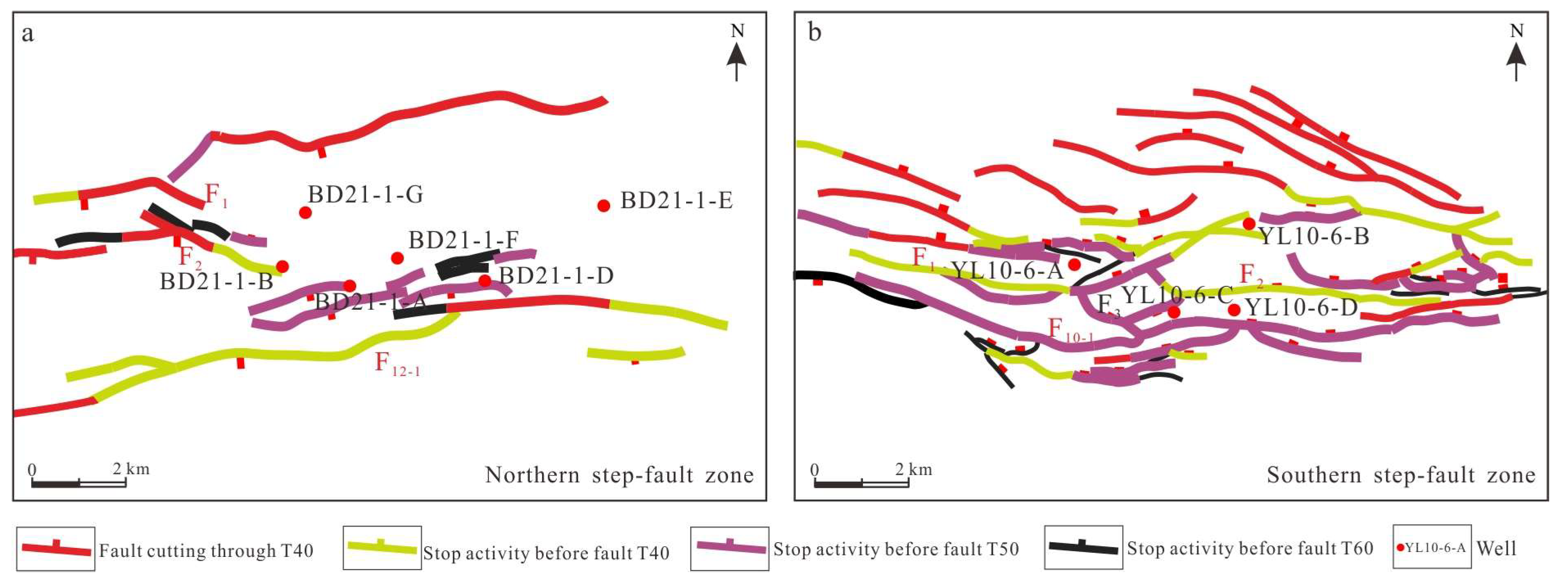
6.1. Distribution of Natural Gas

Hydrocarbon source rock evaluation is a crucial aspect of petroleum system research [43,44]. The BD21-1 block in the northern step-fault zone of the Baodao sag is surrounded by the following three hydrocarbon-generating depressions: A sub-sag, B sub-sag, and C sub-sag (Figure 5). These sub-sags possess high organic matter abundance and thick hydrocarbon source rocks, which are key to hydrocarbon accumulation. Kerogen microscopy analysis reveals that the hydrocarbon source rocks in the Baodao sag have a significant proportion of vitrinite, with organic matter types mainly ranging from II2 to III, and a relatively large proportion of Type-III kerogen, which is primarily associated with gas and gas–oil generation (Figure 6). According to the pyrolysis data of hydrocarbon source rocks collected from CNOOC (China) Limited Hainan Branch [42], the black-gray mudstones developed in the E3y have a value ranging from 0.66% to 1.11%, with an average of 0.82%, and a w (S1 + S2) ranging from 0.61 to 4.46 mg/g, with an average of 3.04 mg/g. These mudstones are considered moderately good to good hydrocarbon source rocks. The thickness of the hydrocarbon source rocks in this formation is significant, especially within sub-sag C in the southern part of the BD21-1 block, where the thickness is mainly 600 to 800 m, reaching up to 900 m. This provides a high-quality material foundation for the formation of the BD21-1 gas field. Compared to the northern step-fault zone, the YL10-6 block in the southern step-fault zone has only one hydrocarbon-generating sub-sag, with a w (TOC) value ranging from 0.44% to 1.13%, averaging 0.71%, and a w (S1 + S2) ranging from 0.75 to 3.59 mg/g, averaging 2.08 mg/g, which is considered moderately good. The thickness of the hydrocarbon source rocks in the E3y is mainly between 500 and 700 m. Overall, the BD21-1 block in the northern step-fault zone has more hydrocarbon-generating depressions, which are more conducive to oil and gas enrichment and accumulation.

6.2. Sedimentary Faces and Physical Properties of the Reservoir

The deep-water area of the Baodao sag is characterized by the development of submarine fans. During the deposition of the upper Oligocene Lingshui Formation, the sediment sources of the Baodao sag mainly originated from the Shenhu uplift in the northeast. With rapid basin subsidence and seawater intrusion, coastal-shallow marine deposition dominated. The E3l3 is in a period of fault–depression transition, with rising sea levels and the extensive development of shallow sea areas. Multiple braided river deltas develop in the catchment areas between faults, which are continuously distributed in the north (Figure 7). The lithology is mainly interbedded with gray, medium-coarse sandstone and gray mudstone. In addition, the existing oil and gas flow wells and oil and gas display reveal that the reservoir layer of the Baodao sag is mainly the third member of the Lingshui Formation of the Upper Miocene, and the type of rock is mainly sandy rock. The reservoirs of the E3l3 are dominated by feldspathic quartz coarse-to-medium sandstones. The clastic particles are mainly medium-grained, with some coarse grains. The sorting is moderate to good, and the rounding is sub-angular to sub-rounded. The particles are mainly supported by granular contacts, with line–point contacts, developed feldspar dissolution pores, and poorly developed cementation, which result in good pore connectivity.
The reservoir space is divided into primary and secondary pores. The primary pores in the Lingshui Formation account for about 52.78%, with a maximum of 58.12%. The intergranular pores are triangular, quadrangular, etc., with varying pore diameters and a face porosity of 7.69%. The compaction effect is strong, with only a small amount of residual intergranular pores and secondary growth karst pores being visible (Figure 8), while the overall porosity of the reservoir is poor. The measured permeability of most samples is between 0.1 × 10⁻³ µm2 and 10 × 10−3 µm2, and the porosity is between 0 and 20% (Figure 9), which indicates a medium-porosity and low-permeability reservoir. The sand of the braided river delta in the research area is mainly distributed around the fault of F12 and F12-1, providing excellent storage sites for oil and gas. Under high-pressure conditions in deep-water areas, the continuous sand bodies and thick layers of medium-low porosity and medium-low permeability reservoirs formed by the braided river delta can achieve high productivity [45].

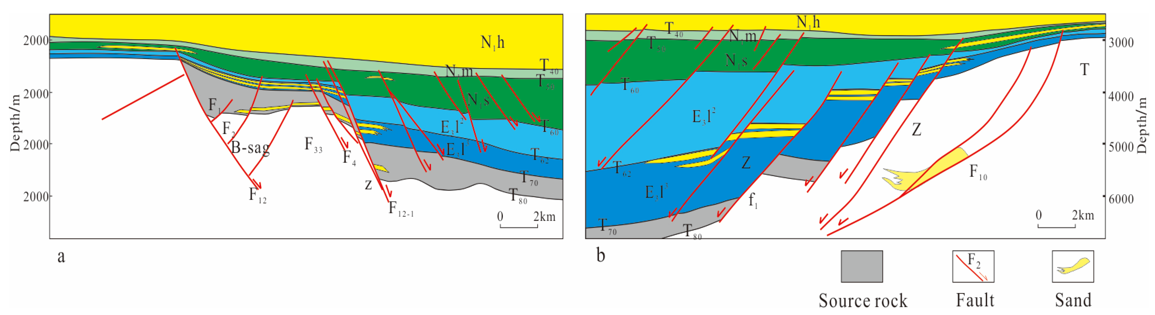
6.3. Fault and Secondary Migration

The differences in the initial migration conditions are as follows: The effectiveness and development of the initial migration are related to large-scale sand bodies with large contact areas with source rocks [46]. The actual drilling results and seismic data indicate that the YL10-6 block and the BD21-1 block have similar characteristics, but no large-scale oil and gas reservoirs have been discovered. During this period, a large-scale fan delta developed in the northern step-fault zone, extending into the interior of the hydrocarbon-generating main depression. From the analysis of the actual lithology, during the sedimentation of the E3y, approximately 60 m thick feldspathic sandstone and 150 m thick interbedded fine sandstone and mudstone were deposited. The thickness of a single layer is mostly over 5 m, with a maximum of 49 m. Compared to the northern step-fault zone, the sedimentary scale of the fan delta during the third stage of the E3y in the southern step-fault zone is smaller and has not extended into the hydrocarbon-generating depression. Therefore, the initial migration conditions in the northern step-fault zone are better than those in the southern step-fault zone.
The differences in the storage conditions for secondary migration are as follows: The fault activity in the BD21-1 block of the northern fault terrace zone is characterized by the late cessation of activity of the controlling concave large fault and the early cessation of activity of the controlling ring fault. Partial sections of the control concave fault remain active after T40 (10.5 Ma), while most secondary faults cease activity before T60 (23.03 Ma) (Figure 10a and Figure 11a). The late-stage activity of the control concave fault provides the main channel for the upward transport of oil and gas in the source rocks. Natural gas is transported vertically from the source rocks of the Yacheng Formation and then laterally through the sand into a relatively stable trap composed of inactive secondary faults. The faults in the southern step-fault zone generally have the characteristics of late cessation of activity near the center of the depression and early cessation of activity away from the center of the depression. Taking the area of Well YL10-6-A as an example, the activity of the control circle F1 stopped before T50 on the west side, with poor transport conditions and good preservation conditions. The formation of the trap controlled by this well is due to the late cessation of fault activity in the north and the communication with the source rock, which enters the trap through vertical transport combined with short-distance lateral transport. The main fault in the trap of Well YL10-6-C stopped activity before T50 (15.97 Ma), with poor conductivity and good preservation ability (Figure 10b and Figure 11b). Oil and gas are mainly transported vertically through the northern step-fault zone, and then laterally through sand into traps to form reservoirs. Compared with the northern step-fault zone, the southern step-fault zone lacks large-scale stable blocks, and its transport and preservation capabilities have zoning characteristics. The fault on the north side of the southern fault has a strong transport capacity but a weak preservation capacity. Oil and gas reservoirs are mainly formed through vertical transport combined with short-distance lateral transport into relatively well-preserved traps; in addition, near the uplift area, the fault transport capacity is weak, while the preservation capacity is enhanced. Oil and gas reservoirs are mainly transported vertically through the northern fault and then laterally over a long distance into the trap.

6.4. Model of Reservoir Formation

Multiple hydrocarbon generation centers are developed within the Baodao sag. The thick source rocks of the Yacheng Formation have high gas generation intensity, providing the material basis for the formation of large gas fields. The fault terraces adjacent to the hydrocarbon generation centers are controlled by multiple major strike–slip faults, serving as preferred areas for natural gas migration. The sediment source from the Shenhu uplift injects into the northern fault terrace, where large, continuous braided river delta sand bodies control structural-lithologic traps. Additionally, the overlying thick mudstones of the Sanya Formation provide sealing conditions, favorable for the formation of traps in large gas fields. In the BD21-1 block of the northern step-fault zone, vertical migration was mainly controlled by F12 and F12-1 in the early stage, supplemented by lateral migration through the sand. At the end of the Lingshui Formation, the traps generally exhibited a west-high to east-low pattern (Figure 12). The structural high was located in the western part of the block, while the eastern part was at a structurally lower position, with no significant trap development. The traps were finalized at the end of the Sanya Formation (Figure 12). During this period, the overall pattern of the block underwent significant changes. The western structural high shifted from a northwest position to nearly an east–west orientation, and, due to the uplift of the eastern edge, structural-lithologic traps formed in the eastern part of the block. Later, the Dongsha movement and Neotectonic movements led to continuous changes in the structural highs within the traps, ultimately forming the current west-low to east-high morphology. Overall, it is characterized by three main hydrocarbon charging events, multiple stages of reservoir formation, and near-source accumulation (within 10 km). Therefore, the northern step-fault zone exhibits a model of reservoir formation, as follows: “multiple depressions generating hydrocarbons and controlling the source—large faults controlling continuous vertical migration—long lateral sand body convergence (T + Z-type migration)—multiple seal layers.”
In the YL10-6 block of the southern step-fault zone, vertical migration was mainly controlled by F10-1 and F1 in the north in the early stage, supplemented by lateral migration through the sand. The traps formed at the end of the Lingshui Formation were finalized at the end of the Sanya Formation. Later, the Dongsha movement and Neotectonic movements caused local tectonic stress changes in the faults controlling the traps. Due to the compressive stress formed by the local strike–slip faults, small, compressional anticline traps formed along F10-1 in the south. With two main hydrocarbon charging events, it belongs to multiple stages of reservoir formation. Therefore, the southern fault terrace exhibits a model of reservoir formation, as follows: “mixed hydrocarbon sources—large faults controlling continuous vertical migration—short lateral sand body convergence (Z-type migration)—multiple seal layers” (Figure 12).

7. Conclusions

(1)
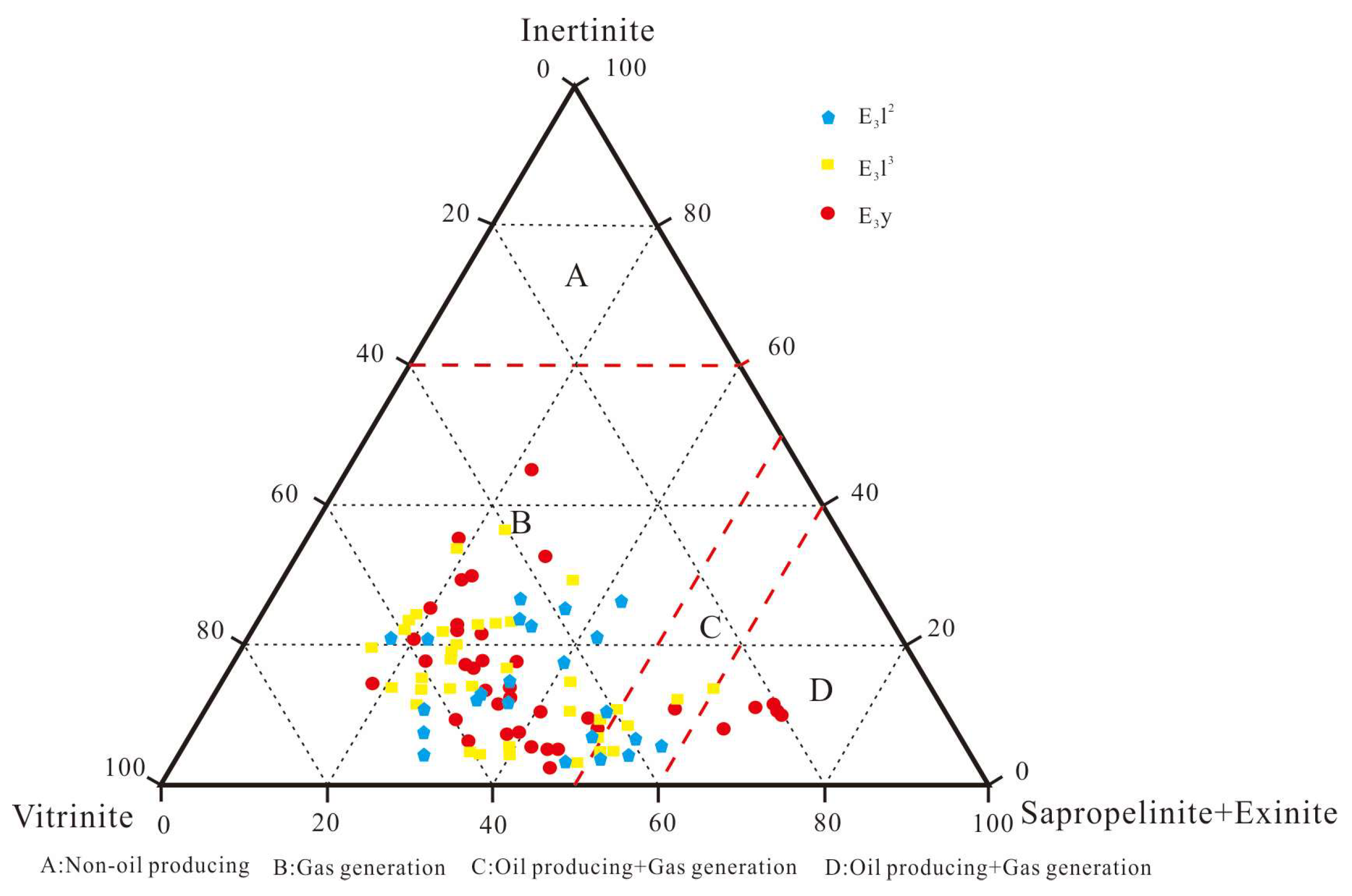
The source rocks of the Yacheng formation in the Baodao sag are thick and have significant hydrocarbon generation potential. The northern step-fault zone has a low methane volume fraction of CH4, a high volume fraction of non-hydrocarbon gas, and a dryness coefficient generally greater than 0.90, indicating dry gas dominance. In contrast, the southern step-fault zone has a high hydrocarbon gas volume fraction in natural gas composition, exhibiting a mixture of dry and wet gases.
(2)
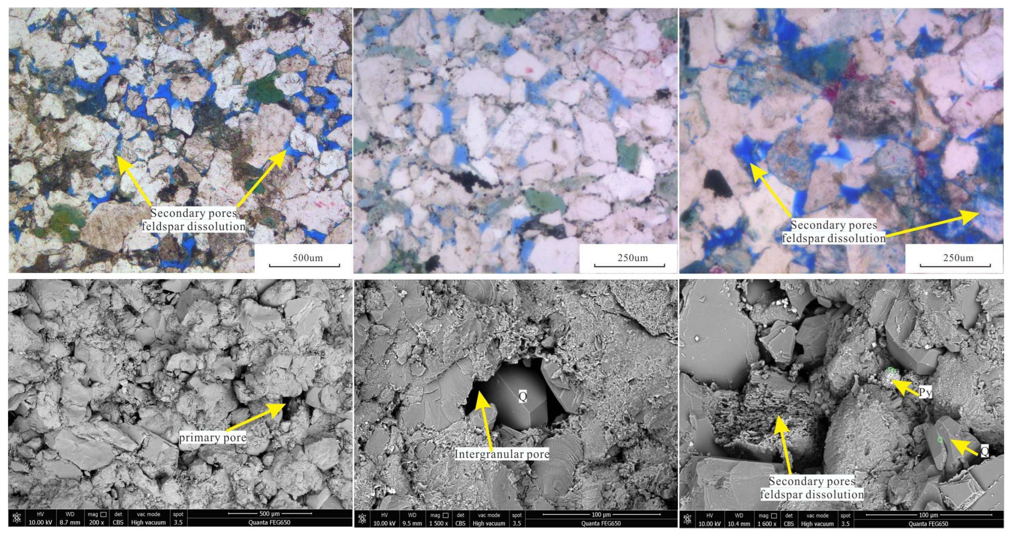
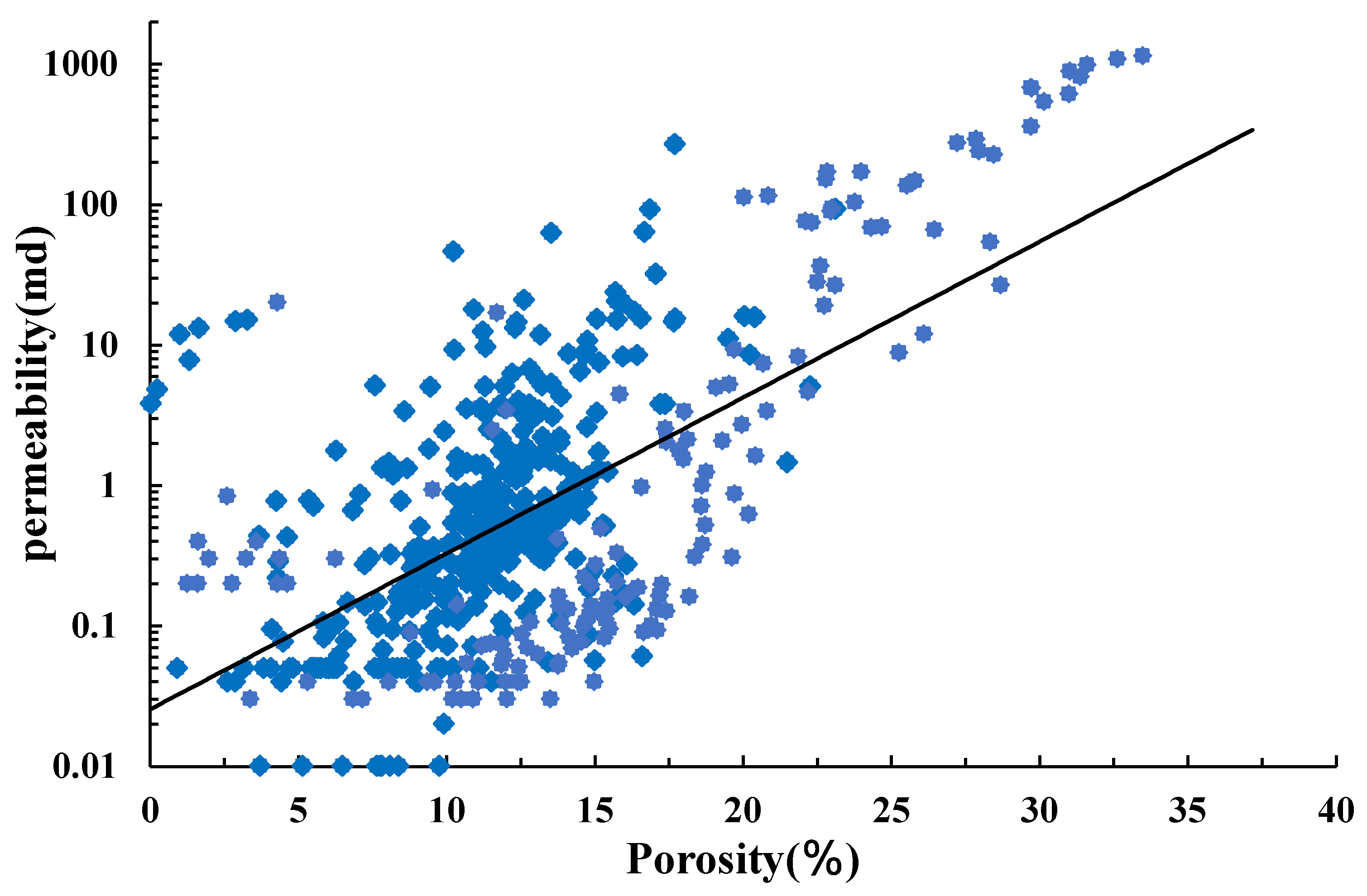
The accumulation of natural gas in the Baodao sag is controlled by multiple factors, such as the source rocks, tectonic activity, sedimentary evolution, and the types of transport systems. The thick source rocks of the Yacheng Formation are the main oil-generating layers. The reservoirs of the E3l are the main reservoir system in the Baodao sag. They are of braided river delta origin, dominated by feldspathic quartz, coarse-to-medium sandstones with medium-grained clastic particles. The high productivity was controlled by the medium-to-low porosity and medium-to-low permeability characteristics of these reservoirs.
(3)
There are certain differences in the natural gas reservoirs within the Baodao sag, and there are three stages of oil and gas injection in the north, developing a typical reservoir formation model, as follows: “multiple depressions generating hydrocarbons and controlling the source—large faults controlling continuous vertical migration—long lateral sand body convergence (T + Z-type migration)—multiple seal layers”. In contrast, two hydrocarbon charging events were found in the south, with a reservoir formation model as follows: “mixed hydrocarbon sources—large faults controlling continuous vertical migration—short lateral sand body convergence (Z-type migration)—multiple seal layers”.

Author Contributions

Conceptualization, X.Y., X.X. and N.W.; methodology, Y.T. and Y.F.; software, Y.F. and G.Z.; validation, J.G. and X.X.; formal analysis, J.G. and G.Z.; investigation, Y.T. and G.Z.; resources, N.W. and X.X.; data curation, X.Y., Y.T. and Y.F.; writing—original draft preparation, X.Y.; writing—review and editing, N.W. and J.G. All authors have read and agreed to the published version of the manuscript.

Funding

This research was funded by the National Natural Science Foundation of China, grant number 42172179.

Data Availability Statement

The raw data supporting the conclusions of this article will be made available by the authors upon request.

Conflicts of Interest

Author Jun Gan, Xiaofeng Xiong and Gaokun Zuo were employed by the company of China National Offshore Oil Corporation (CNOOC). The remaining authors declare that the research was conducted in the absence of any commercial or financial relationships that could be construed as a potential con-flict of interest.

References

  1. Zhang, G.C.; Qu, H.J.; Zhao, C.; Zhang, F.; Zhao, Z. Giant discoveries of oil and gas exploration in global deep waters in 40 years and the prospect of exploration. Nat. Gas Geosci. 2017, 28, 1447–1477. [Google Scholar] [CrossRef]
  2. Zhang, G.; Qu, H.; Zhang, F.; Chen, S.; Yang, H.; Zhao, Z.; Zhao, C. Major new discoveries of oil and gas in global deepwaters and enlightenment. Acta Pet. Sin. 2019, 40, 1–34, 55. [Google Scholar] [CrossRef]
  3. Zhang, G.C.; Mi, L.J.; Qu, H.J.; Feng, Y.W.; Fan, Y.H. A basic distributional framework of global deepwater basins and hydrocarbon characteristics. Acta Pet. Sin. 2011, 32, 369–378. [Google Scholar] [CrossRef]
  4. Zhang, F.L. Seismic Interpretation and Reservoir Formation Conditions of Lithologic Body of Sanya Formation in Changchang Sag, Qiongdongnan Basin; Northwest University: Xi’an, China, 2018. [Google Scholar]
  5. Shi, H.S.; Yang, J.H.; Zhang, Y.Z.; Gan, J.; Yang, J.H. Geological understanding innovation and major breakthrough to natural gas exploration in deep water in Qiongdongnan Basin. China Pet. Explor. 2019, 24, 691–698. [Google Scholar] [CrossRef]
  6. Zhou, J.; Zhu, J.T.; Yang, J.H.; Jiang, R.F.; Zhang, Y.; Gan, J.; Sun, Z.P. Characteristics of faults and their implication to gas geology in Baonan step-fault zone in deep-water area of Qiongdongnan Basin. Nat. Gas Geosci. 2018, 29, 87–95. [Google Scholar]
  7. Gong, C.L.; Li, D.W.; Steel, R.J.; Peng, Y.; Xu, S.H.; Wang, Y.M. Delta-to-fan sourceto-sink coupling as a fundamental control on the delivery of coarse clastics to deepwater: Insights from stratigraphic forward modelling. Basin Res. 2021, 33, 2960–2983. [Google Scholar] [CrossRef]
  8. Tian, H.X.; Lin, C.S.; Zhang, Z.T.; Li, H.; Zhang, B.; Zhang, M.L.; Liu, H.Y.; Jiang, J. Depositional architecture, evolution and controlling factors of the Miocene submarine canyon system in the Pearl River Mouth Basin, northern South China Sea. Mar. Pet. Geol. 2021, 128, 104990. [Google Scholar] [CrossRef]
  9. Bi, G.X.; Lyu, C.F.; Li, C.; Chen, G.J.; Zhang, G.C.; Zhou, Q.S.; Li, C.Z.; Zhao, Y.L. Impact of early hydrocarbon charge on the diagenetic history and reservoir quality of the Central Canyon sandstones in the Qiongdongnan Basin, South China Sea. J. Asian Earth Sci. 2019, 185, 104022. [Google Scholar] [CrossRef]
  10. Wu, W.; Li, Q.; Yu, J.; Lin, C.S.; Li, D.; Yang, T. The Central Canyon depositional patterns and filling process in east of Lingshui Depression, Qiongdongnan Basin, northern South China Sea. Geol. J. 2018, 53, 3064–3081. [Google Scholar] [CrossRef]
  11. Yao, X.Z.; Feng, C.J.; Qu, H.J.; Chen, J.; Sun, M.S. Depositional pattern and source-to-sink process of submarine fans in Lingshui Formation and Sanya Formation, Baodao Sag, Qiongdongnan Basin. Nat. Gas Geosci. 2023, 34, 2075–2086. [Google Scholar] [CrossRef]
  12. Zhu, W.L.; Shi, H.S.; Huang, B.J.; Zhong, K.; Huang, Y.W. Geology and geochemistry of large gas fields in the deepwater areas, continental margin basins of northern South China Sea. Mar. Pet. Geol. 2021, 126, 104901. [Google Scholar] [CrossRef]
  13. Zhong, J.; Wang, Y.Q. Geochronology, Geochemistry Characteristics and Tectonic Setting of the Songnan Low Uplift Granite of Qiongdongnan Basin. J. Jilin Univ. (Earth Sci. Ed.) 2022, 52, 134–148. [Google Scholar]
  14. Zhang, Y.Z.; Xu, X.D.; Gan, J.; Zhu, J.T.; Guo, X.X.; He, X.H. Study on the Geological Characteristics, Accumulation Model and Exploration Direction of the Giant Deepwater Gas Field in the Qiongdongnan Basin. Acta Geol. Sin. 2017, 91, 1620–1633. [Google Scholar]
  15. Wang, Z.F.; Sun, Z.P.; Zhang, Y.Z.; Guo, M.G.; Zhu, J.T.; Huang, B.J.; Zhang, D.J.; Jiang, R.F.; Mang, X.; Zhang, H.Y. Distribution and Hydrocarbon Accumulation Mechanism of the Giant Deepwater Central Canyon Gas Fieldin Qiongdongnan Basin, Northern South China Sea. China Pet. Explor. 2016, 21, 54–64. [Google Scholar]
  16. Deng, Y.; Pei, J.X.; Hu, L.; You, L. Discovery and Hydrocarbon Accumulation Models of Baodao 21-1 Gas Field in the Western South China Sea. China Offshore Oil Gas 2022, 34, 13–22. [Google Scholar]
  17. Xu, C.G.; Deng, Y.; Wu, K.Q.; Hu, L.; You, L. Discovery and Geological Significance of the Large Gas Field Baodao 21-1 in a Passive Picontinental Basin with Strong Activity in the Northern South China Sea. Acta Pet. Sin. 2023, 44, 713–729. [Google Scholar] [CrossRef]
  18. Xu, C.G.; You, L. North Slope Transition Zone of Songnan-Baodao Sag in Qiongdongnan Basin and Its Controlon Medium and Large Gas Fields, South China Sea. Pet. Explor. Dev. 2022, 49, 1061–1072. [Google Scholar] [CrossRef]
  19. Gan, J.; Zhang, Y.Z.; Lin, L.; Liang, G.; Li, X. Main Controlling Factors of Natural Gas Differential Accumulation Model, in Baodao Sag, Qiongdongnan Basin. Earth Sci. 2023, 48, 439–450. [Google Scholar] [CrossRef]
  20. Yuan, Z.Y.; Tian, Y.; Xiong, X.F.; Ye, L.; Zuo, G.K.; Wu, N.; Zhu, J.J. Comparative Analysis of Gas Enrichment Differences in the Third Member of the Paleogene Lingshui Formation in the South-North Step-Fault Zone of Baodao Sag, Qiongdongnan Basin. J. Jilin Univ. (Earth Sci. Ed.) 2024, 54, 1998–2013. [Google Scholar] [CrossRef]
  21. Zhong, J.; Yang, X.B.; Zhu, P.Y.; Xu, S.L.; Deng, X.L.; Tuo, L.; Li, X.; Song, P. Porosity Evolution Differences of the Lingshui Formation Reservoir between Baodao and Changchang Sag, Qiongdongnan Basin. Earth Sci. 2019, 44, 2665–2676. [Google Scholar] [CrossRef]
  22. Liao, G.L.; Yan, Z.Y.; Li, B.Q.; Guo, Y.Q.; Wu, Z.Z. Discussion on genesis types and gas sources of natural gas in deep water area of Qiongdongnan Basin: Taking Lingshui formation of BX-1 structure on northern slope of Baodao Sag as an example. J. Xi’an Shiyou Univ. (Nat. Sci. Ed.) 2024, 39, 21–28. [Google Scholar]
  23. Jiang, R.F.; Cao, L.C.; Deng, X.L.; He, Y.L.; Jiao, Y.Q.; Chen, Z.G.; Li, T.; Zhang, Q. Sedimentary characteristics of the Lingshui Formation in the Baodao 21-1 area of the Qiongdongnan Basin and their significance in hydrocarbon exploration. Bull. Geol. Sci. Technol. 2024, 43, 31–44. [Google Scholar] [CrossRef]
  24. Guo, S.S.; Liao, G.L.; Liang, H.; Peng, Z.C.; Wang, S.Y. Major Break through and Significance of Deep-Water Gas Exploration in Well BD21 in Qiongdongnan Basin. China Pet. Explor. 2021, 16, 49–59. [Google Scholar] [CrossRef]
  25. Lei, C.; Ren, J.Y.; Li, X.S.; Tong, C.X.; Yin, X.Y.; Min, H. Structural Characteristics and Petroleum Exploration Potential in the Deep-Water Area of the Qiongdongnan Basin, South China Sea. Pet. Explor. Dev. 2011, 38, 560–569. [Google Scholar]
  26. Dai, N.; Zhong, N.N.; Deng, Y.H.; Li, W.; Kang, H.Q. Genetic Types of Marine Source Rock in Meso-Cenozoic Continental Margin Basins. Acta Pet. Sin. 2015, 36, 940–953. [Google Scholar]
  27. Wu, P.; Hou, D.J.; Gan, J.; Ding, W.J.; Liang, G.; Li, X.; Feng, X.L.; Wang, H. Developmental Model of Oligocene Source Rock in the Eastern Deep-Water Area of Qiongdongnan Basin. Acta Sedimentol. Sin. 2019, 37, 633–647. [Google Scholar]
  28. Han, G.M.; Li, X.S.; Wang, L.F.; Wei, K.S.; Liu, W.J. New Explanation of Fault System in Baodao Sag’s Northern Slope of Qiongdongnan Basin and Its Affect for Natural Gas Accumulation. Nat. Gas Geosci. 2013, 24, 352–355. [Google Scholar]
  29. He, W.H.; Wang, W.; Yin, H.W.; Liu, S.W.; Zhu, J.T.; Xiong, X.F. Structural Evolution in Deep Water Area of Qiongdongnan Basin and Comparison of Structural Differences Between Eastern and Western Segments. Geol. J. China Univ. 2022, 28, 644–654. [Google Scholar] [CrossRef]
  30. Yang, J.H.; Yang, X.B.; Zhou, J.; Gan, J.; Song, A.X.; Jiang, F.; Yang, L. Characteristics of Inversion Structure Belts and Their Hydrocarbon Geological in the Songnan-Baodao Sag in Deep Water Area of the Qiongdongnan Basin. Haiyang Xuebao 2019, 41, 97–106. [Google Scholar] [CrossRef]
  31. Lei, C.; Ren, J.Y.; Pei, J.X.; Lin, H.T.; Yin, X.Y.; Tong, D.J. Tectonic Pattern and Curtain Evolution of the Deep-Water Zone in the Qiongdongnan Basin. Earth Sci. J. China Univ. Geosci. 2011, 36, 151–162. [Google Scholar]
  32. Taylor, B.; Hayes, D.E. The Tectonic Evolution of the South China Basin//Hayes D E. The Tectonic and Geologic Evolution of Southeast Asian Seas and Islands; American Geophysical Union: Washington, DC, USA, 1980; pp. 89–104. [Google Scholar]
  33. Yao, B.C.; Wan, L.; Wu, N.Y. Cenozoic Plate Tectonic Activity in the Great South China Sea. Geol. China 2004, 31, 113–122. [Google Scholar]
  34. Lin, C.S.; Chu, F.Y.; Gao, J.Y.; Tan, Y.H. On the Tectonic Movement of the Cenozoic in the South China Sea. Haiyang Xuebao 2007, 29, 87–96. [Google Scholar]
  35. Ren, J.Y.; Pang, X.; Yu, P.; Lei, C.; Luo, P. Characteristics and Formation Mechanism of Deep water and Ultra-Deep water Basins in the Northern Continental Margin of the South China Sea. Chin. J. Geophys. 2018, 61, 4901–4920. [Google Scholar] [CrossRef]
  36. Ren, J.Y.; Luo, P.; Gao, Y.Y.; Wang, H.J.; Lei, C.; Chao, P. Structural, Sedimentary and Magmatic Records During Continental Breakup at Southwest Sub-Basin of South China Sea. Earth Sci. 2022, 47, 2287–2302. [Google Scholar]
  37. Zhou, G.; Hu, D.S.; You, J.J.; Zhu, J.T.; Yang, X.; Li, X. Geochemical Characteristics and Sourcesof Natural Gas in the Weixinan Sag, the Beibuwan Basin. Nat. Gas Geosci. 2024, 35, 1923–1934. [Google Scholar]
  38. Dai, J.X. Significance of the Study on Carbon Isotopes of Alkane Gases. Nat. Gas Ind. 2011, 31, 1–6. [Google Scholar]
  39. Dai, J.X.; Xia, X.Y.; Qin, S.F.; Zhao, J.Z. Causation of Partly Reversed Orders of δ13C in Biogenic Alkane Gas in China. Oil Gas Geol. 2003, 24, 1–6. [Google Scholar]
  40. Dai, J.X.; Zou, C.N.; Zhang, S.C.; Li, J.; Ni, Y.Y.; Hu, G.Y.; Luo, X.; Tao, S.Z.; Zhu, G.Y.; Mi, J.K.; et al. Identification of Organic Alkane Gases and Inorganic Alkane Gases. Sci. Sin. Terrae 2008, 38, 1329–1341. [Google Scholar]
  41. Dai, J.X.; Ni, Y.Y.; Qin, S.F.; Huang, S.P.; Peng, W.L.; Han, W.X. Geochemical Characteristics of Ultra-Deep Natural Gas in the Sichuan Basin, SW China. Pet. Explor. Dev. 2018, 45, 588–597. [Google Scholar] [CrossRef]
  42. You, L.; Quan, Y.B.; Tuo, L.; Teng, C.Y.; Zuo, G.K. Natural Gas Sources and Migration Path ways of the Baodao21-1 Gas Field in the Deep-Water Area of the Qiongdongnan Basin. Oil Gas Geol. 2023, 44, 1270–1278. [Google Scholar] [CrossRef]
  43. Dembicki, H., Jr.; Horsfield, B.; Ho, T.T. Source rock evaluation by pyrolysis-gas chromatography. AAPG Bull. 1983, 67, 1094–1103. [Google Scholar] [CrossRef]
  44. Peters, K.E.; Cassa, M.R.; Magoon, L.; Dow, W. The petroleum system-From source to trap. AAPG Mem. 1994, 60, 93–120. [Google Scholar]
  45. Stricker, S.; Jones, S.J.; Sathar, S.; Bowen, L.; Oxtoby, N. Exceptional Reservoir Quality in HPHT Reservoir Settings: Examples from the Skagerrak Formation of the Heron Cluster, North Sea, UK. Mar. Pet. Geol. 2016, 77, 198–215. [Google Scholar] [CrossRef]
  46. Liu, D.L.; Du, Z.M.; Xu, X.M.; Wu, J.; Zhang, Q.; Tao, Y.; Dong, W.; Chen, S.H. The Main Controlling Factors of the Effectiveness of Paleoproterozoic Oil and Gas Primary Transport: The Comparison of the Oil and Gas Exploration Effectiveness of Xijiang A and Xijiang B Tectonic, Enclosures in the Pearl River Estuary Basin as an Example. Mar. Geol. Front. 2017, 33, 40–48. [Google Scholar] [CrossRef]
Figure 1. Location and stratigraphic column of the study area: (a) Location map of Qiongdongnan Basin, (b) Comprehensive stratigraphic column of the Baodao sag.
Jmse 13 00774 g001
Figure 2. Characteristics of natural gas components in the north–south step-fault zone of the Baodao sag.
Jmse 13 00774 g002
Figure 3. δ13C113C213C3 discriminant diagram of deep natural gas origin of the Paleogene in the south–north step-fault zone of the Baodao sag.
Jmse 13 00774 g003
Figure 4. Histogram of homogenization temperature distribution of fluid inclusions and burial history. (a) in the northern fault-step zone, (b) in the southern fault-step zone.
Jmse 13 00774 g004
Figure 5. Thickness map of source rocks in the south–north step-fault zone of the Baodao sag.
Jmse 13 00774 g005
Figure 6. Microscopic composition of kerogen in the Baodao sag.
Jmse 13 00774 g006
Figure 7. Sedimentary facies plan of the third member of Lingshui Formation in the south–north step-fault zone of the Baodao sag (a) and lithology histogram of Well BD21-1-A (b).
Jmse 13 00774 g007
Figure 8. Microscopic characteristics of the sandstone reservoir of the E3l3 in the Baodao sag.
Jmse 13 00774 g008
Figure 9. Intersection diagram of porosity–permeability of the E3l3 in the Baodao sag.
Jmse 13 00774 g009
Figure 10. Diagram of transport system in the south–north step-fault zone of the Baodao sag.
Jmse 13 00774 g010
Figure 11. Relative activity period of faults in the south–north step-fault zone of the Baodao sag.
Jmse 13 00774 g011
Figure 12. Hydrocarbon accumulation model and structure of the Baodao sag.
Jmse 13 00774 g012
Table 1. Natural gas composition and carbon isotope data of the third member of the Paleogene Lingshui Formation in the south–north step-fault zone of the Baodao sag.
Tectonic ZonesWellDepth/mφ(C1)/%φ(C2+)/%φ(CO2)/%φ(N2)/%δ13C1/‰δ13C2/‰δ13C3/‰δ13C4/‰
Northern step-fault zoneBD21-1-A4092.4~4154.066.546.0527.140.38−39.53−28.42
BD21-1-B4268.560.659.4728.992.32−39.09−29.76−27.62−26.39
4479.569.8214.1115.890.43−40.16−30.42−26.67−25.81
BD21-1-C4218.541.388.5448.830.06−40.95−28.81−25.82−24.96
BD21-1-E3823.361.745.0113.1920.50−40.59−30.33−27.41
BD21-1-F4358.5~4369.036.894.3158.81 −40.79−30.32−27.13−25.21
4372.5~4386.037.143.4929.37 −40.92−28.54−27.19−25.73
4395.2~4403.037.713.6058.68 −41.10−29.25−27.19−25.75
Southern step-fault zoneYL10-6-A5066.072.8924.75 −37.45−28.18−26.24
5139.186.376.367.26 −39.33−29.47
YL10-6-B5144.994.034.511.46 −40.05−29.87
5150.094.424.870.71 −39.73−29.44
YL10-6-C4020.081.749.242.336.68
Disclaimer/Publisher’s Note: The statements, opinions and data contained in all publications are solely those of the individual author(s) and contributor(s) and not of MDPI and/or the editor(s). MDPI and/or the editor(s) disclaim responsibility for any injury to people or property resulting from any ideas, methods, instructions or products referred to in the content.

