Review

Coastal Vulnerability: A Brief Review on Integrated Assessment in Southeast Asia

by
Noorashikin Md Noor
1,* and
Khairul Nizam Abdul Maulud
1,2
1
Earth Observation Centre, Institute of Climate Change, Universiti Kebangsaan Malaysia, Bangi 43600, Selangor, Malaysia
2
Department of Civil Engineering, Faculty of Engineering and Built Environment, Universiti Kebangsaan Malaysia, Bangi 43600, Selangor, Malaysia
*
Author to whom correspondence should be addressed.
J. Mar. Sci. Eng. 2022, 10(5), 595; https://doi.org/10.3390/jmse10050595
Submission received: 17 April 2022 / Accepted: 25 April 2022 / Published: 28 April 2022
(This article belongs to the Special Issue Coastal Risk Assessment and Management)

Abstract

:
Coastal zones are an essential part of maintaining sustainability in the world. Coastal regions have gained importance due to various factors, including high ecological production, dense population, industry compatibility, waste disposal, leisure, transportation, and development of military strategies. Coasts are often on the move and must adapt while nature constantly works to maintain balance. Southeast Asia has gained prominence due to its rich ecosystem, high productivity, and densely populated coastal region. In light of this, the coastlines of Southeast Asia are threatened by various factors, including global climate change and human activities. These factors exacerbate the shoreline erosion, frequent catastrophic events, rising sea levels, and saltwater intrusion. Coastal management has become one of the most important challenges of the past decade. The coastal vulnerability index (CVI) was developed to identify and manage vulnerable locations along the coast. Thus, this review attempts to summarize coastal vulnerability in Southeast Asian based on journals and reports. Topics covered include: (1) introduction to coastal vulnerability, (2) methods for determining coastal vulnerability, (3) factors influencing coastal vulnerability (4) associated coastal vulnerability, (5) assessment gaps, and (6) further courses of action. Consequently, assessment of coastal vulnerability will support Southeast Asian coastal communities in guiding mitigation strategies to manage coastal threats in future climate change and urban development.

1. Introduction

Vulnerability to hazards is the result of the complex and dynamic interaction of economy, environmental, and social factors [1]. Coastal hazards have an impact on a variety of ecological systems, including forest, rivers, wetlands, lakes, and marine environments, as well as human systems, such as natural resources, agriculture, health, and communities. These dynamics, which operate on multiple spatial and temporal scales within the linked human-environmental system, create vulnerability by affecting individuals’ and communities’ ability to prepare, cope, and recover from the effects [2]. The degree of vulnerability is determined by a coastal system’s susceptibility, resilience, and resistance to hazards [3]. Susceptibility is an intrinsic feature of a coastal system that indicates its vulnerability to being impacted by a hazard [4]. A system with soft sediments, for example, is more vulnerable to storm surge changes than a system with hard sediments. Resilience and resistance are aspects of a system’s stability in the presence of hazard. Resilience is defined as the speed with which a system recovers from a hazard, whereas resistance is termed as a system’s ability to avoid hazard [3]. Prior to a hazard, a coastal system’s resistance is important, while resilience is important after a hazard.
Vulnerable coastlines have a low coastal elevation, abrasive sediment, high tide energy, and a greater chance of experiencing storms, such as cyclones and coastal erosion [5] (as shown in Figure 1). Coastal systems become more vulnerable when sea levels rise and storm frequency increases. The vulnerability in the coastal zone is being accessed by system susceptibility, resilience, and resistance, allowing adaptive management plans to be developed in perspective with the latest Intergovernmental Panel on Climate Change (IPCC) report [6]. The physical characteristics of the shoreline are altered by human activity, leading to a loss of ecology resilience and protection that a coastline could have supplied in the event of a disturbance [7]. The coastal system’s resilience is harmed by increased ecosystem stress caused by human activity. As a result, increased populations and infrastructure in coastal areas make coastal environments, population, and infrastructure more vulnerable.
The coastline of Southeast Asia is one of the most dynamic links in the world, spanning the land-sea divide and supporting some of the world’s most biodiverse environments [8]. It covers approximately 20% of the Earth and is home to a substantial amount of the world’s population. Different weather conditions have led to more significant geomorphological variability of coasts that includes coastal regions, swamps, sea slopes, and corals. As a result, humans became captivated by them and began to use them in various ways. Coastal areas have been the focus of intense development and tourism, but they are now subjected to shifting processes that have resulted in climate change [9]. Logging, agricultural fertilizer waste, and raw wastewater threaten the swamp and reef as well. With around 40% of the world’s citizens living within 50 km of the sea, the coastline is getting polluted, generating a health crisis. Physical factors that are both powerful and dynamic impact the coastline along with its ecology, thus creating threats to the population of humans [3]. Increased storm intensity, resulting tides and coastal flooding, frequent flood, erosion of the coastline, as well as the increased inflow of toxins like harmful algae bloom (HAB), expose the coastal ecosystem to threats that emerge in the Southeast Asia’s coastline and urging nations to consider where and how to protect vulnerable coastal resources. Events such as Typhoon Rai in Philippines (2021) [10], Central Vietnam Flood (2020) [11], Cyclone Seroja in Indonesia (2021) [12], deadly HAB in Malaysia (2015) [13], and Typhoon Damrey in Thailand (2017) [14] illustrate the need of assessing coastal vulnerability in order to advise effective coastal zone management Along with its geographical location, the Philippines is highly vulnerable to coastal flooding and severe rains, as well as strong winds, which result in heavy losses with agricultural and household damage [10].
Southeast Asia has a disproportionate amount of significant catastrophes in comparison to other parts of the world. Southeast Asia’s coastlines are particularly vulnerable to hydrometeorological disaster. During the 2015-2020 period, hydrometeorological hazards contributed for 80% of recorded disasters and 60% of fatalities. Floods are the most common types of disaster, accounting for 50% over all people affected and 30% of economic damage [15]. During this time, economic damage has increased significantly. Table 1 illustrates the number of people killed and affected in Southeast Asia’s coastal countries between 2015 and 2020. These six countries alone contributed approximately 16% of the total number of people that died and 35% of those affected worldwide. Natural disaster consequences are substantially diversified and unevenly dispersed among Southeast Asia’s regions. Due to their geographic position, climate, geology, and ability to cope with extreme conditions, some regions are more vulnerable than others [16]. Much of this growth has occurred in low-lying flood plains, river deltas, and estuaries that are vulnerable to coastal risk. Key socioeconomic changes influencing coastal vulnerability in Southeast Asia include increasing population density as well as growth, rapid and poor planned urbanization, migration to the coast, and improper development in high-risk areas for tourism, transportation and industry [17]. These processes result in large-scale land-use changes and hydrological system transformations in coastal areas, as well as the degradation of coastal ecosystems with the loss of biodiversity [18], all of which are key indicators of vulnerability.
Climate change is estimated to worsen the exposure of many coastal regions, making them more vulnerable to coastal hazards [19]. One of the most significant signs of climate change is the rise in sea level. Between 1990 and 2100, the global mean sea level is estimated to increase by 0.09 to 0.88 m [6], resulting in four important biogeophysical consequences in coastlines: wetland replenishment, coastline erosion, storm flooding and damage, and an increase in the salinity of estuaries [20]. These effects could have a variety of socioeconomic consequences, such as the loss of economic, ecological, cultural, and subsistence values due to the infrastructure, loss of land, and coastal habitats; increased flood risk to people, land, and infrastructure, as well as the aforementioned values; and other effects related to changes in water management, salinity, and biological activities [21].
Climate change is also projected to increase variability and affect the severity, frequency, and duration of catastrophic disasters [6]. Climate change is anticipated to increase the intensity of tropical cyclone wind and precipitation in some areas of tropical Southeast Asia, causing coastal erosion, damage to homes and infrastructure, and damage to coastal ecosystems, such as mangroves and reefs [22]. Drought and flood occurrences are expected to worsen, as well as greater variability in Asian summer monsoon precipitation [23]. Climate change has the potential to damage decades of development assistance, poverty alleviation, and disaster relief activities. Extreme occurrences occur so regularly in many developing and least-developing countries that they appear to overwhelm the nation’s adaptive capacity and impede long-term growth as attention and resources urgently required for poverty reduction and economic development are shifted to disaster relief efforts. Developing countries (e.g., Brunei, Indonesia, Malaysia, the Philippines, Thailand, and Vietnam) are overwhelmingly affected by climate change because climate-sensitive industries, such as fisheries and agriculture, which are economically important. These countries have limited human, institutional, and financial capacity to prepare for and respond to the impacts of climate change [23,24].
Given the importance of protecting these Southeast Asian regions, namely Myanmar, Vietnam, Laos, Thailand, Cambodia, Malaysia, Brunei, Philippines, Indonesia, and Singapore (Figure 2) with various coastal structures to reduce or mitigate coastal erosion problems, frequent floods, and increased storm intensity, this review has been prepared to examine the lessons learned from the coastal vulnerability assessment. Besides, this review aims to highlight the challenges related to the definition of coastal vulnerability, compare and assess methodologies used in vulnerability assessment, and explore knowledge gaps and way forward related to the assessment of coastal vulnerability based on a review of reviewed journals and reports.

2. Methods in Determining Coastal Vulnerability

The vulnerability of coastal areas due to climate change can be assessed in various ways. There are several models for assessing vulnerability to sea level rise and, consequently, coastal vulnerability assessment. The four types of coastal vulnerability assessments based on methods are by [9]:
i.
Indexes
ii.
Indicators
iii.
Geographical Information System (GIS)
iv.
Dynamic computer models
Some reviews have been conducted to assist coastal managers in choosing an appropriate method for assessing coastal vulnerability [25,26]. While models can target single or multiple hazards, optimizing vulnerability assessments requires integrating all the different types of risks faced by a coastal zone. In addition, the vulnerability assessment should integrate current and projected risks due to climate change or human activities [27]. The index method is a simple, rapid, and systematic tool and is one of the most important methods for assessing coastal vulnerability to the effects of sea level rise, particularly erosion and flooding [28]. An index based on physical variables, such as coastal landforms, relief, geology, relative sea level rise, coastal drift, tidal range, and wave height has been widely used to assess coastal vulnerability in Southeast Asia. These four methods can be mapped to highlight vulnerable regions in Southeast Asia and identify the highest risk contributing to coastline changes.

2.1. Indexes

Gornitz created the coastal vulnerability index (CVI) concept [21], considering the consequences of the rise in sea levels (particularly flood and erosion) using the following parameters: geomorphology, shoreline change frequency, the slope of the coast, rate of sea level, wave height, and range of tide. In recent years, there has been a substantial increase in vulnerability indices for specific coastal locations. Coastal indexes were created to group coastlines under homogeneous groups with comparable characteristics. These classifications can then aid the establishment. The Gornitz [21] formula was used for most vulnerability evaluations. Later, the CVI assessment was improved by changing the availability and geographic location parameters.
Composite vulnerability indices and multiple-scale coastal vulnerability indexes have resulted from the development of CVI assessment. Different subindices based on parameter features are used in a multiple scale CVI, which are then blended for overall CVI, considering both the socioeconomic vulnerability index (SVI) and physical vulnerability index (PVI). The PVI risk factors observed are coastal slope, geomorphology, elevation, coastline fluctuation, rising sea level, range of tide, the height of the wave, and SVI risk factors consisting of road network, tourism, land use and population. PVI and SVI are then calculated using the hierarchical analytical process (AHP), and the overall CVI is determined by the formula CVI = (PVI + SVI)/2 [10]. AHP is a process involving multiple criteria in deciding which various variables are given a priority ranking [11]. The factors, which are dependent on the physical properties of the area, are the initial stage in determining the CVI. These characteristics are quantified and ranked, with the most common being low, moderate, high, and very high. Ghazali et al. [23] investigated the northwest of Peninsular Malaysia coastal vulnerability by summing factors and assigned values to different factors. The authors looked at five parameters and assessed vulnerability by adding a parameter to the variables based on the parameter’s relevance and the effect of sea-level rise, with the following results: geomorphology, the slope of the coast, coastline change, tide range, and wave height.

2.2. Indicators

A simple vulnerability indicator for natural phenomena, for example, may be characterized as a factor that can affect the vulnerability. The method based on indicators considers risk potential, multiple vulnerability factors that influence risk, and the ability to adapt [24]. Most studies of natural phenomena concentrate on physical processes, and there is a need to investigate the socioeconomic factors, which requires using an indicator-based approach. There are several approaches to assess vulnerability. Using an indicator-based approach, Huu et al. [24] assessed the coastal vulnerability of Vietnam’s Mekong Delta using indicators, focusing on five primary parameters: tourism, urbanization, industry, agriculture and sport activity.

2.3. Geographical Information System (GIS)

In numerous analyses, coastal vulnerabilities are displayed using a GIS. The use of the square root of the output average, for example, has been combined with GIS approaches to evaluate the coastal vulnerability [28]. Physical vulnerability is measured by the square root of the parameter’s average, while social and environmental vulnerabilities are calculated using the normalized technique. In ArcGIS software, the three vulnerabilities are combined and visually shown as reported by Malaysia, Thailand, and Vietnam, in order to map the vulnerable coastlines. Climate change risk and the adaptation efforts simulator (simCLIM), community vulnerability assessment tool (CVAT), dynamic interactive vulnerability assessment (DIVA), and coastal and climate decision support systems (DSS) have been developed and publicly available [29]. The Digital Shoreline Assessment System (DSAS) has been widely used with ESRI ArcGIS 10 extension program to measure the rate of change of coastline. To diminish the risk of cyclones, the Ayeyarwady Delta coast of Myanmar has implemented integrated coastal zone management (ICZM), which then developed an expert decision support system (EDSS) for coastal cyclone and storm vulnerability [30].
In the monitoring and mapping of geo-hazards, satellite remote-sensing data combined with GIS provides an excellent alternative to traditional mapping methodologies. It is used to handle, gather, share, record, analyze, update, organize, and integrate spatial (geographic) information extracted from Global Positioning System (GPS), maps, and remote sensing. GIS allows mapping and transforming overall risks data into visual information [16]. GIS is the most direct method for mapping any risk area closely. It is an important tool for expanding, developing, and testing vulnerability models that explicitly focus on area [17].

2.4. Dynamic Computer Models

Dynamic computer models have been developed to analyze and map coastal systems’ risks. Sector models and integrated assessment models are the two types of models. These models were developed to assess risks and vulnerabilities for components as well as many parameters when used together [18]. The DIVA-coast and dynamic interactive vulnerability assessment (initially known as DIVA) synthesis and upscaling of sea-level rise vulnerability assessment research (SURVAS), and the community vulnerability assessment tool (CVAT) are some of the models developed for vulnerability assessment [31].
In general, indicators and index-based systems are simple to implement. Their use along the Southeast Asian coastline is heavily reliant on data availability. This could be a key barrier in putting some of the methods discussed at the Southeast Asian coastline scale to practice [32]. Adjustments to the method may be required to account for significant features in different regions and make the best use of the available data [33]. Indicators or index-based methods are practical for scoping or first-look evaluations—and thus for identifying priority coastlines and systems at risk—but not for a more extensive quantitative assessment of coastal vulnerability and the selection of adaptation options. Indicators and indexes can be highly beneficial for communication because of their simplified methods. The final calculated indexes do not allow the users to identify the assumptions and evaluations that direct their calculation; hence index-based techniques are not immediately evident. A detailed explanation of the methodology used is required to assist the proper implementation of these methods [34].
The conclusions were drawn concerning the possible use of models to estimate coastal vulnerability to climate change in Southeast Asi, based on the review of the main pros and cons [35] as well as the main characteristics summarized in the overview table (Table 2). SimCLIM and DIVA are the two main relevant methods. A thorough assessment of vulnerability in Southeast Asian coastal areas is the goal, and socioeconomic and environmental aspects must be considered. They can provide information to stakeholders regarding the impact of sea-level rise in locations where resources and population are closely connected. Nonetheless, they are distinct: DIVA is an open-source model in development, but SimCLIM is a pre-installed, commercial piece of software that needs special training. SimCLIM contains a simple impact model for CVI based on provided situations preloaded in the scenario generator framework for assessing the consequences. DIVA incorporates a wide range of climate change impacts, such as salinity intrusion and erosion flooding, however, it requires external climatic situations to operate. SimCLIM is valid from local to global scales by incorporating the appropriate data through multiple modules, whereas DIVA is well designed to analyze regional and factors global levels. SimCLIM and DIVA tend to be valuable tools for assessing national and international authorities’ vulnerability, mitigation, and adaptive ability when considering the prior characteristics [36].

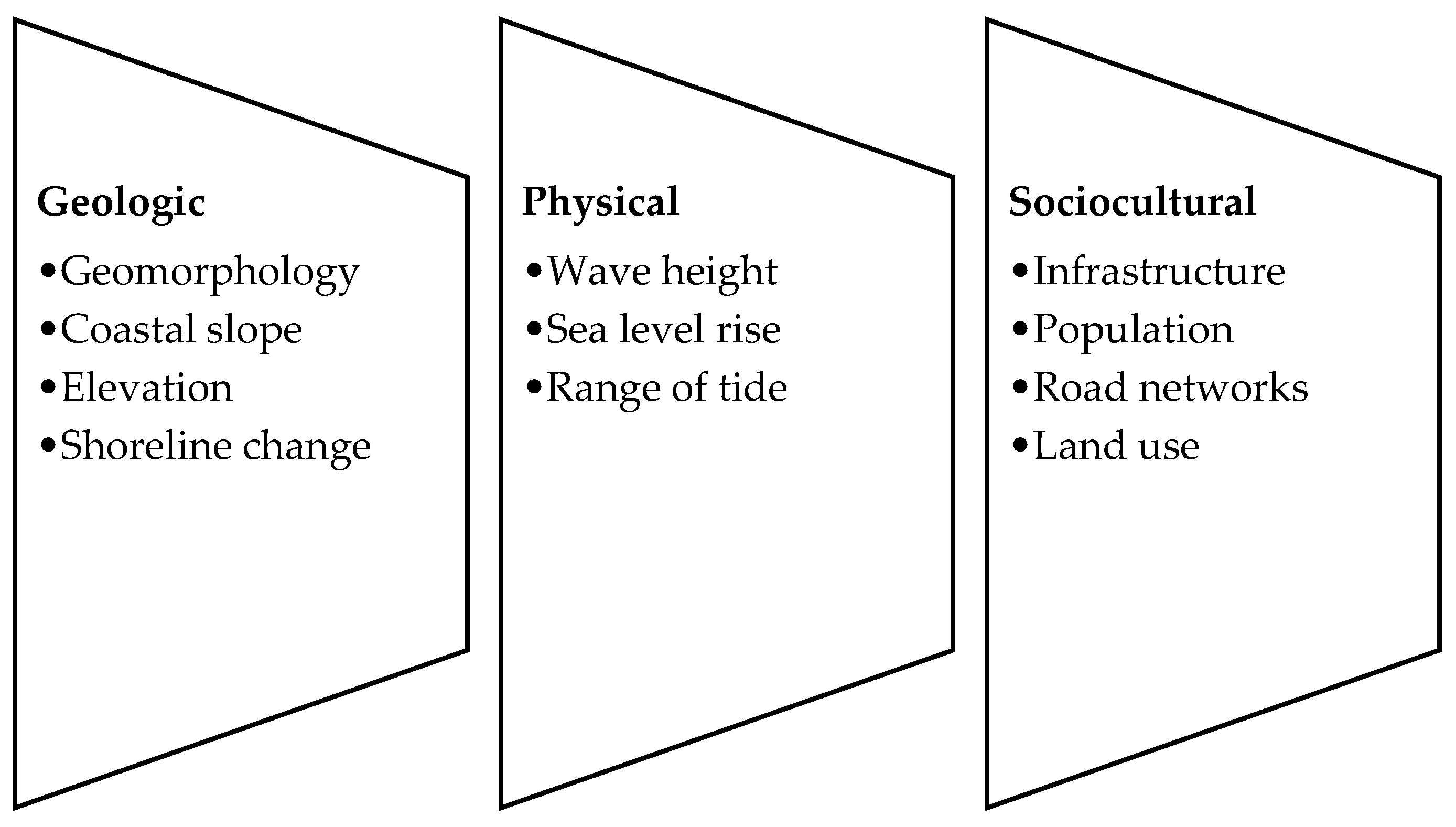
3. Factors Affecting Vulnerability

Naturally occurring changes in coastal shorelines of Southeast Asia are caused by a variety of coastal phenomena, including geologic, physical, and sociocultural as summarized in Figure 3. This factor creates a connection between shoreline changes and erosion, as well as vulnerability. Erosion-prone coastlines are considered more susceptible due to the loss of land, facilities, and coastal ecosystems. Additionally, erosion shortens the distance between villagers and the sea, thus widening the risk of vulnerability in the community. As more land is formed (accreting deltas), coastlines are subjected to accretionary processes [37].
Among the geologic factors is geomorphology, which is the concept that examines landscapes plus the geological events that generated them and the identification of commonalities between them. Geomorphology determines the erodibility of various landform types, which is particularly important for coastal vulnerability [16]. Due to the high erosion caused by waves and storms, coastal landforms, such as intertidal flats, marshes, and dunes, will be redistributed due to erosion and rising sea levels. Coastal habitat and population/infrastructure vulnerability will alter as coastal geomorphic characteristics evolve. For example, coastal locations with stony shorelines are particularly less vulnerable. Coastlines with sandy or muddy structures, such as beaches or swamps, are most susceptible to erosion and rising sea levels [38]. The next geologic factor is a slope that measures the coast’s steepness or gradient [39]. The coast’s slope implies the possibility of floods and rapid shoreline retreat. Due to the slope’s link to the floods as a result of rising sea levels or storms, this is a relevant thing to keep in mind when assessing vulnerability. Reduced, gentler slopes have a higher risk of flooding and land loss, while higher, steeper slopes have a lower risk of flooding and land loss. The coastal elevation is relevant to use in assessing vulnerability because it could be used to (1) detect and measure the scope of land threatened by sea-level rise, (2) potentially predict land available for mangrove relocation, and (3) evaluate the effects of rising of sea level on community [39]. Since higher altitudes are more resistant to flooding caused by sea-level rise or storm, coastal regions with higher elevations are considered less vulnerable. As a result, lower-elevation coasts are particularly prone to flooding and erosion. Additionally, geology studies the rock types that make up the coastline as the substrate to erosion, determined by the relative hardness of the minerals that make up the rock type. Rocks, sediments, erosional sediments, and reefs are all forms of geology found in the coastal systems [40]. Coastlines with resilient geological formations are least susceptible to the storm’s eroded effects and rising sea level. In comparison, coastlines with loose sediments are more susceptible to erosion caused by storms and rising sea levels. Tides are highly predictable and are a product of the moon and sun’s gravitational pull. The tidal range is the vertical distance between the highest recorded tide and the lowest tide at a coastline. It is common to label beaches with an extensive range of tides as extremely vulnerable [41].
Another factor in considering coastal vulnerability is physical, which includes the rising sea levels. Due to the possibility of coastal land being inundated, coasts exposed to the rising sea level are considered highly vulnerable locations. Coasts with low rates of sea level rise are less susceptible to flooding. Rising sea levels influence coastal erosion, geomorphology, land utilization, and a supply of groundwater [42]. The term wave height refers to differences between mean and significant wave height. The trough’s height to crest in the highest waves in 12 h is defined as the wave height. The wind that creates the waves determines the height of the waves. An important component of coastal sediment transport, wave energy is proxied by significant wave height. Therefore, the mobilization and transport of coastal debris increases as wave energy increases. Coastlines with a greater magnitude of significant waves are more susceptible to those than a smaller magnitude of significant waves [43].
The population of a coastline lies under sociocultural factors. People are invested in protecting their property against erosion and floods; hence the population variable is sometimes seen as an economic indicator too. Furthermore, population growth may result in increasing erosion along the coastline [44]. Protecting houses, possessions, land, and infrastructure on a coastline with a bigger population will cost more money. A coastal zone with a smaller population, on the other hand, is less vulnerable to environmental degradation and has less infrastructure to protect [45]. Besides, the use of land can be classified according to various criteria, including economic, culture, and environment [43]. Most of the time, land usage is classified and evaluated based on its monetary value to humans. For example, industrial infrastructure with agricultural lands is considered very vulnerable. The advantages and services given by the coastline and the possible value for the land in the future are not considered in this land-use ranking approach.
However, although promised, the data were never forthcoming. Therefore, the rationale used for the economic ranking was based on a subjective assessment of which land-use types were more or less valuable to humans than, others Typically, land use is defined and valued according to its economic importance for humans. Land use for human value is considered more vulnerable than less valuable, human-valued land uses [46]. Furthermore, infrastructure is another element under sociocultural factors. It is a broad term that encompasses residential and commercial structures. Among them are wastewater treatment plants, electric generating plants, schools, and hospitals, which are all considered in economic analyses. Coastlines with infrastructure are more vulnerable than the coastline with no infrastructure [47]. Coastline locations with a high density of roadways, such as highways or expressways, are highly susceptible, whereas coastlines without roadways are significantly less susceptible.

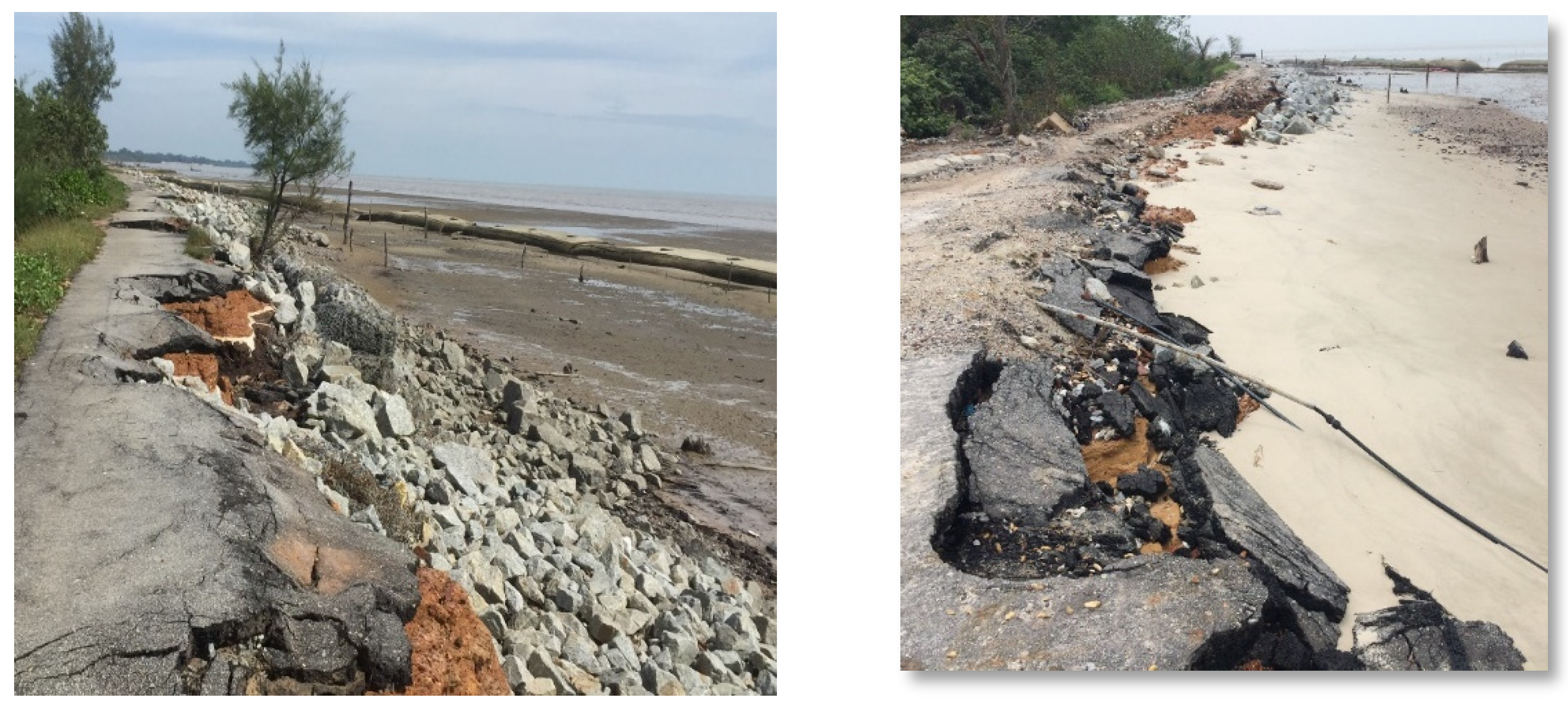
4. Vulnerabilities Associated with Southeast Asian Coast

Several different formulas (Table 2) were used to construct and estimate coastal vulnerability assessments, though they were mostly based on formulas developed by Holling and Pimm [3,4]. The sum of products and product means of the square root product were used to generate the coastal vulnerability assessments. The product means were applied in two coastal vulnerability index calculations [48]. The square root of the product means was applied the most, 19 times in total. The total of products was utilized three times to evaluate coastal vulnerability assessments. Two alternative techniques, the sum of products and the square root of the product mean, were used to calculate the coastal vulnerability index in two different assessments [49].
Table 2. A summary of location, parameters, and calculation of CVI in Southeast Asia for the past five years.
LocationParametersCVI CalculationReference
Thanh Hóa, VietnamFlood, Typhoon, Storm(X1 + X2 + X3 + … Xn)/nHens et al. [37]
Central VietnamFlood, storm,
landslide
(X1 + X2 + X3 + … Xn)/nHoang et al. [22]
Phetchaburi,
Thailand
Erosion(X1 + X2 + X3 + … Xn)/nRitphring et al. [39]
Prachuap Khiri Khan, ThailandSea Level Risesqrt ((X1 × X2 × X3 × … Xn)/n)Nidhinarangkoon et al. [50]
Riau, IndonesiaErosionsqrt ((X1 × X2 × X3 × … Xn)/n)Sandhyavitri et al. [40]
Aceh Besar, IndonesiaErosionsqrt ((X1 × X2 × X3 × … Xn)/n)Irham et al. [41]
Davao del Norte, PhilippinesCyclone, Rainfall, Erosion, Flood(X1 + X2 + X3 + … Xn)/nJocsonand Magallon [42]
Marinduque Island, PhilippinesFlood(X1 + X2 + X3 + … Xn)/nPrasetyo et al. [43]
Pahang’s Coast, MalaysiaSea Level Rise(X1 × X2 × X3 × … Xn)/nMohd et al. [44]
Cherating, MalaysiaSea Level Risesqrt ((X1 × X2 × X3 × … Xn)/n)Mohd et al. [44]
Kelantan and Terengganu’s Coast, MalaysiaSea Level RiseCVI = sqrt ((X1 × X2 × X3 × … Xn)/n)Ariffin et al. [45]
Tutong River basin, BruneiFloodsqrt ((X1 × X2 × X3 × … Xn)/n)Jha et al. [46]
Coastal of CambodiaLandslidesqrt ((X1 × X2 × X3 × … Xn)/n)Horlings and Marschke [47]
Ayeyarwady Delta coast, MyanmarCyclonesqrt ((X1 × X2 × X3 × … Xn)/n)Hirano [48]
Southern Myanmar coastStormsqrt ((X1 × X2 × X3 × … Xn)/n)Mandle et al. [49]
Sqrt: square root; n is the number of associated parameters; X is a parameter.
In addition, a novel tool for evaluating coastal vulnerability, such as the use of scaling or weighting factors, geometric means, and normalizing variables, was created. Five coastal vulnerability assessments used a scaling or weight factor for each variable, whereas three used the normalization technique [50]. In an evaluation, the geometric mean of all the ranked variables was applied. It was also used in two freely available coastal vulnerability assessment visualization platforms. The most vulnerable areas include the Philippines’ regions, Vietnam’s Mekong River Delta region, virtually all around Cambodia, North and East Laos, Bangkok of Thailand, and west and south Sumatra of Indonesia. From most of the Southeast Asian countries, the Philippines is vulnerable not only to tropical cyclones, particularly in the north and east, but also to a variety of other climate-related hazards, such as flooding (Southern Mindanao and central Luzon), landslides (owing to the state’s landscape), and droughts [31]. The National Capital Region is the Philippines’ most vulnerable area. The densely populated National Capital Region of the Philippines is particularly sensitive to a variety of climate hazards (flood and cyclone). These findings support prevailing perceptions that Southeast Asia’s most vulnerable areas comprise the Mekong River Delta, Vietnam [11] as well as Bangkok, both of which are sensitive to rising sea levels [33]. Apart from areas bordering the Mekong River Delta, Vietnam (prone to flood and rising sea level), nearly every province in Cambodia is vulnerable due to its weak adaptation capacity. On the other hand, Kelantan and Terengganu are the most vulnerable (due to flooding) states in Malaysia [23].
Furthermore, considering the regional norm, western and eastern Java places are also vulnerable. Central Jakarta ranks top in the total vulnerability evaluation despite having the best adaptation capacity score according to the ASEAN State of Climate Change Report [36]. This is because, except for tropical cyclones, this district sits at the intersection of all climate-changed dangers. This area is regularly flooded, but it is highly vulnerable because it is one of Southeast Asia’s most densely populated areas. Western Java is also particularly vulnerable due to many dangers (including floods and landslides) and high population density.
The collection of data is essential for assessing the risk because there are many compelling parameters. Two types of data are collected in order to assess the risk. The first is conventional data, and the second is spatial data. The first is based on ground and aerial surveillance inspections in the field, whereas the second is based on spatial sensors [51]. Table 3 lists the many datasets that are accessible for the study; some are freeware, while others are for commercial use. The majority type of data collected were conventional data, which are labelled as in situ data or point level observations collected all throughout the year. Aerial photogrammetry images and topographic maps have conventionally been utilized to measure shoreline erosion and sea level rise [52]. This technique must be conducted in the course of appropriate tidal datum, i.e., mean high tide. The sea level rate was calculated from the in situ measurement of the tide gauge.
The combination of geographical (satellite pictures, regional maps) and non-spatial (statistics records, socioeconomic factors) data is another sort of data. The spatial data are used to specify where the features appear, thereby supplying geographical references for the non-spatial data, which document what the features indicate using a variety of characteristics [53]. All of this spatial data can be divided into two categories: primary (those gained through field and laboratory activity) and secondary (those obtained through scientific literature, databases). The visual and digital interpretation and analysis of cartography and remote sensing products yielded some data (LANDSAT and airborne RADAR band X). Fieldwork between 2000 and 2015 enabled georeferencing of natural and man-made components, identification of morphological features and processes, confirmation of remote sensing image analysis results, and, lastly, design of coastal vulnerability [54].

5. Gap in Coastal Vulnerability Assessment

The review looked at coastal vulnerability assessments in Southeast Asia, examining different components of vulnerability and applying a number of variables and calculations. The range of coastal vulnerability assessments evaluated reflects the influence of various factors, the most important of which is the scope and objective of the assessment [53]. Although tropical cyclones and coastal flooding were considered, the aim of constructing coastal vulnerability assessments was strongly linked to erosion or rising sea level. In coastal vulnerability assessments, geological and physical process factors have been most frequently identified, particularly in Indonesia and Thailand.
Shoreline changes, geology, and geomorphology were the geological variables most commonly considered when assessing coastal vulnerability. These variables indicate coastal processes that influence coastal erodibility. Geology and geomorphology are included as one variable in Vietnam [55], since landform and landform rock type are frequently included in geomorphology. The physical variables most typically examined when measuring coastal vulnerability were mean wave height, sea level rise, significant wave height, and mean tidal range. These variables mostly represent the possibility of coastal flooding [56]. Both significant and mean wave heights are used as indicators for wave energy, and one or the other was frequently used in the assessments. Researchers developed extensive coastal vulnerability assessments along the coasts of Thailand and Vietnam that focused on geological and physical vulnerabilities [33,57]. These pioneering coastal vulnerability assessment efforts in Southeast Asia continue to affect the coastal vulnerability study. Therefore, many coastal vulnerability assessments applied similar variables.
Coastal vulnerability in Southeast Asia was calculated in a variety of ways, including utilizing the square root of product mean, product mean, sum of products, square root of the product mean, or weighted variables of the variable of interest. The square root of the product mean was the most commonly used formula. Though coastal vulnerability can be evaluated using the sum or product of the variables, the product has the advantage of a wider range of values [58]. It has been discovered that weighted variable calculations are more responsive to variances in environmental conditions. The relative relevance of the individual variables determines the weight of the variables [59]. Weighting assignments, on the other hand, are generally based on the best scientific judgement. Furthermore, different ways of assessing vulnerability can yield substantially different outcomes, which has important consequences for decision making.
In general, visualization platforms have just recentely been introduced into coastal vulnerability assessments in Southeast Asia. There are various advantages of incorporating coastal vulnerability assessments into ArcGIS. Recognizing patterns, merging numerous vulnerability impacts (geological and physical vulnerabilities), and visualizing these combined factors along coasts are only a few of the advantages [28]. Coastal vulnerability assessments are improving, with more regular evaluation of the impact of various vulnerabilities and platforms that facilitate the visualization of coastal vulnerability, but there are still substantial problems in producing and enhancing coastal vulnerability assessments. Identifying the factors to include in the collection of data, even including socioeconomic vulnerabilities, are all challenges [60,61]. As a result, the following criteria should be considered when choosing such variables: Is the variable measuring the targeted vulnerability driver? Were there any proven causative links between the measured variable and the process illustrated? Is the combination of many variables indicated in the assessment’s outcome? Is the value of other response variables affected by the combination of multiple variables?
Additional gaps associated with Southeast Asian coastal vulnerability assessments are the use of variables that vary over time, location, and magnitude, which are comparable [62]. The variety of variables addressed in the reviewed assessments reflects these challenges. Coastal environments, as well as coastal communities and infrastructure, are all affected by sea level rise and coastal erosion. Direct loss of economic, cultural, livelihood, and environmental factors due to loss of land, infrastructure, and coastal habitats, increased flood risk to coastal populations, land, and infrastructure, as well as other impacts such as saltwater intrusion, disruption of biological activities, and water are three potential socioeconomic impacts [63].
Moreover, despite the significance of adding socioeconomic vulnerability in assessments and recognition of the socioeconomic vulnerability of coastal regions, socioeconomic variables are commonly ignored from Southeast Asian coastal vulnerability assessments. The removal of socioeconomic elements from the assessment of vulnerable coastal systems can affect the assessment of vulnerable coastal systems [40]. As a result, further assessments that include socioeconomic vulnerability are being constructed. However, integrating socioeconomic vulnerabilities in coastal vulnerability assessments poses significant challenges. Variables, such as human wellbeing and relative as well as perceived human vulnerability, for example, must be constructed [62]. Population increase or decrease, changes in human perceptions, and the installation of new infrastructure are all challenges. Future coastal vulnerability is frequently underestimated due to the dynamic nature of coastal and social dynamics. Furthermore, coastal vulnerability is frequently assessed in order to determine at-risk coastal areas for coastal zone management and to focus restoration activities [56]. Despite this, there are few strategies for connecting vulnerable coastal areas with proper restoration approaches. Future research should look into ways to combine coastal risk assessments with specific mechanisms that can be resolved through coastal protection.

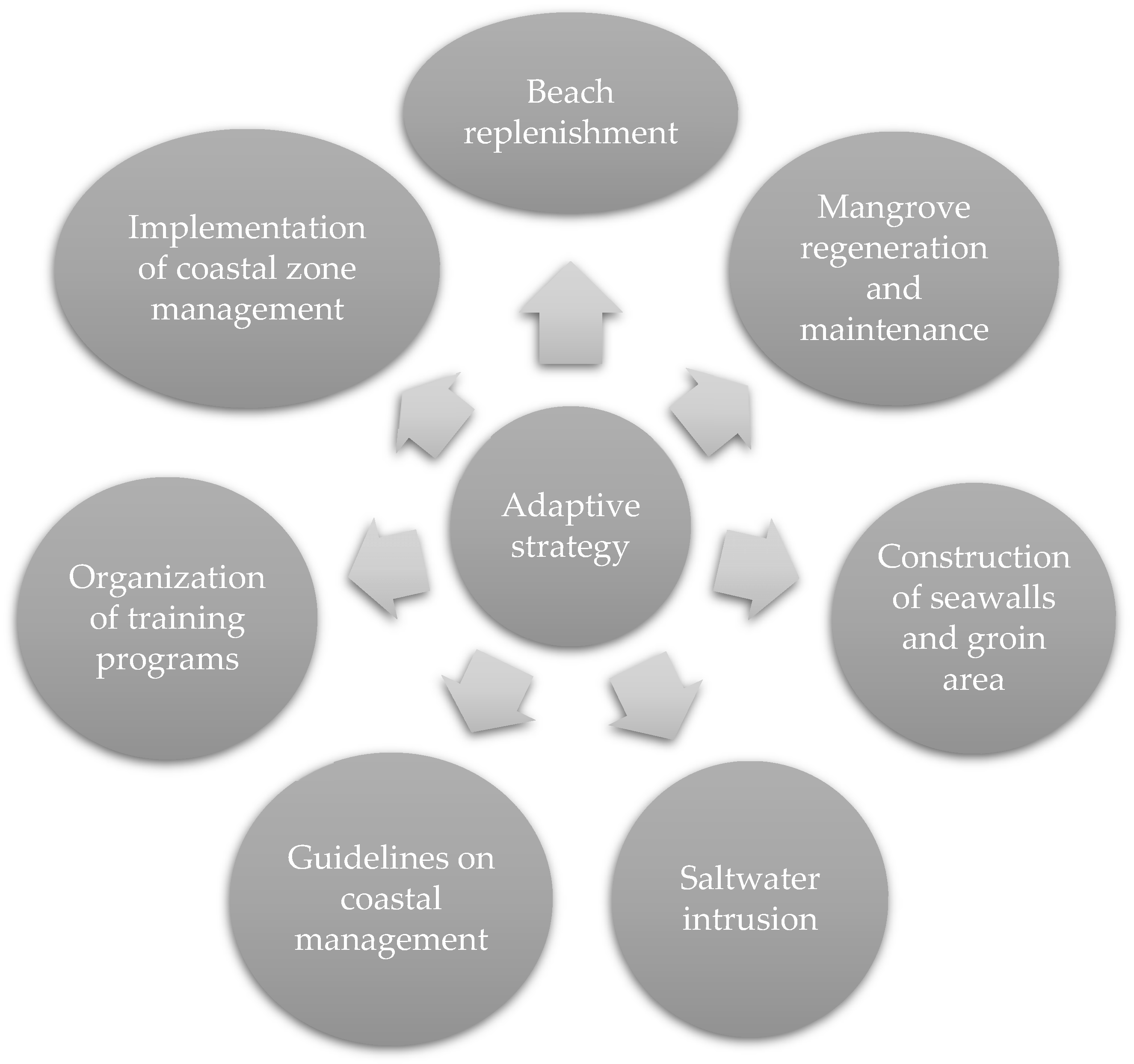
6. Way Forward in Adaptation

The coastline study is problematic since variations may occur pertaining to days or decades. It is critical to monitor, develop, and deploy adaption measures before a hazard occurs in perspective with the latest IPCC report [6]. Unless adapting solutions are implemented, the vulnerabilities will negatively influence Southeast Asia’s livelihoods and socioeconomic situation [63]. A structure at the regional level with detailed specifics, rather than national- and global-level frameworks, will offer a fundamental awareness of the nation’s risk. Coastal vulnerability studies rely on remote sensing and GIS technologies [64]. The most practical strategy for this research is to combine spatial data with traditional data. Remote sensing technology is the most effective method for studying the coasts on a regular basis, as they are continually changing.
In Malaysia, for example, The National Coastal Zone Physical Plan (NPP-CZ) document plays an essential role in the application of the planning framework for coastal zone areas [64]. It should be used to establish a strategic spatial framework for the coastal zone that incorporates the multiple values and synergies between the natural, physical, and socioeconomic systems that interact in this dynamic environment. Nevertheless, the level of use of this document for reference purposes is mainly for development activity in coastal areas and is still at a relatively low level. Thus, the government can oblige all the developers to follow NPP-CZ in order to maintain a productive, safe, and biologically diverse coastal zone for the sake of present and future generations. The existence of this document in Malaysia is often overshadowed by the existence of other documents, such as the National Physical Plan, State Structure Plan, and District Local Plan for planning purposes, other than technical documents mainly produced by the Department of Irrigation and Drainage (DID), such as Integrated Shoreline Management Plan (ISMP). It is suggested that the content of policies and comprehensive strategies contained in the plan document should be optimized for its functions and uses. In general, ISMP and DID are integrated assessments of coastal areas to reduce risks resulting from the process beaches and development activities. Among the objectives of the ISMP is the reassessment of coastal erosion status coastal, studying coastal erosion control methods along with the expected effects after the methods are implemented. The application of ISMP and IRBM strategies needs to be done in the RFZPPN-2 document to ensure uniformity in the aspirations and direction of development for coastal areas. Goals and strategies of the physical plan (for planning documents at the state and national levels) should be backed up by the justification of the need for conservation of the area or development in the area of the coastal zone. Other government plans can be used to help build an understanding of policy formulation as well as development requirements in coastal areas.
Furthermore, organizing ongoing training programs as well as filling of posts related to the field of beach management are important to ensure that the relevant agency tasked with planning and managing the coastal zone is always in a state of readiness. This initiative should be implemented in the regions of Southeast Asia, as it has been conducted in the Philippines as well [43]. The training can be achieved through the following steps: train and provide continuous exposure to agencies (especially the local government) involved in managing and planning of coastal areas, provide assets as well as facilities that match the description as well as the scope of the administrative task agency (boat and equipment related to operations in the sea area), and fill a vacancy or create a new management-related position (professional posts) with a focus area in coastal engineering (example—coastal engineering beaches, geology, fisheries, marine ecology, and other related disciplines). The focus of training should also be on the technical aspects related to management and coastal planning, such as marine hydraulics as well as risk mitigation and disaster management. The training should be ongoing to ensure that the agency tasked with planning and managing the coastal zone is always in state of readiness. Government agencies, private companies, or non-bodies of the government should provide incentives and training to the community to encourage them.
In addition, coastal zone management in each region in Southeast Asia must be implemented by a government agency and private companies to create diverse development without compromising the environment and preparedness for any disasters. The zone management has been implemented in Vietnam, Thailand, Sri Lanka, Indonesia, Malaysia, Myanmar, and Timor Leste [65,66,67,68,69,70,71]; however, it still needs some improvements in preparation for disasters. Therefore, the guidelines are written statements that serve as a reference in proceeding with development. These guidelines shall detail the planning recommendations accordingly along with the physical characteristics of the coast and disaster risk factors, including a planning guide based on disaster risk (tsunamis, coastal erosion, sea-level rise and floods), a planning guide based on physical factors of the beach (sandy beach, grassy beach, rocky beach, etc.), and a planning guide for marine swamp forests and peatland beaches. The purpose is to apply the latest aspects of coastal displacement in detailing the aspects of disaster risk and controlling development so that it is uniform, comfortable, and safe in land-use activities [72]. Every proposed development needs to adhere to the guidelines that have been set.
Figure 4 shows some strategic solutions for adapting coastal vulnerability. Future research will need to look at how coastal risk evaluations incorporate specific mechanisms addressed by coast restoring and defending.

7. Conclusions

Southeast Asia’s economic income is based upon the efficient management of coastal ecosystems over the long term. The growing number of natural hazards throughout the nation’s coasts emphasizes the critical demand for accurate and rapid methods of coastal vulnerability assessment. The world’s coastal zone is becoming increasingly stressed due to increased industrialization tourist activity, the resulting expanding population of humans, and declining water quality. Reservoir, sand mining, beach replenishment, excavation, port development, retaining walls, jetty, and other human activities contribute significantly to coastal vulnerability. Due to human activity, the coastal system becomes more vulnerable with every natural disaster; an example is the decrease in coastal slope due to increased population density. Although coastline erosion has naturally occurred, it is becoming more vulnerable due to human interventions, such as coastal infrastructures. In some ways, one could argue that natural processes are becoming risks as development activities along the coast increase the area’s social and economic worth. Human activity is rapidly increasing and becoming the major source of hazards, making coastal management crucially important. Southeast Asia is essential for its multi-culture, economic, and environmental factors. As a result, the risk of human activity with its land type is important to define vulnerability. The location with the most erosion is that with constructed buildings, and interventions should be taken.
Coastlines in Southeast Asia are highly susceptible to climate change, particularly ocean warming. As a result, for instance, rainfall pattern change, frequency of storms, and rising sea level were observed recently. The fundamental causes of this increased pressure are population expansion, rising urbanization, industry, and tourism in coastal areas. Coastal environments are dynamic systems influenced by both natural and human-made activities. Coastal vulnerability evaluations determine the degree to which different regions are vulnerable. These assessments include geological, physical, and, more typically, socioeconomic factors to identify susceptible coastal locations correctly. The goal, research location, variables evaluated, and coastal vulnerability calculation should be examined in determining Southeast Asia’s coastal vulnerability assessment. Considering the difficulties associated with data collection, socioeconomic vulnerabilities have been acknowledged as an essential component of assessment and are increasingly incorporated in coastal vulnerability assessments. It is suggested that the usage of visual tools improves the relationship of the combined impacts of coastal vulnerability in a centralized repository. The assessment of coastal vulnerability can potentially clarify susceptible coastlines for coastal zone management. However, there is a gap in how to link endangered coastal areas to acceptable restoration strategies, and thus more research is needed to fill in the gap, particularly in Southeast Asia’s coastal zone.

Author Contributions

Conceptualization: N.M.N.; writing—original draft preparation, N.M.N. and K.N.A.M.; writing—review and editing. All authors have read and agreed to the published version of the manuscript.

Funding

This research was funded by UKM YSD Chair of Sustainability, UKM-YSD-2021-003.

Institutional Review Board Statement

Not applicable.

Informed Consent Statement

Not applicable.

Data Availability Statement

Not applicable.

Acknowledgments

We thank the anonymous reviewers for their careful reading of our manuscript and their insightful comments and suggestions. We gratefully acknowledge the staff of the Earth Observation Centre, Institute of Climate Change, UKM.

Conflicts of Interest

The authors declare no conflict of interest.

References

  1. Ummenhofer, C.C.; Meehl, G.A. Extreme weather and climate events with ecological relevance: A review. Philos. Trans. R. Soc. B Biol. Sci. 2017, 372, 20160135. [Google Scholar] [CrossRef] [PubMed]
  2. Rubinato, M.; Heyworth, J.; Hart, J. Protecting Coastlines from Flooding in a Changing Climate: A Preliminary Experimental Study to Investigate a Sustainable Approach. Water 2020, 12, 2471. [Google Scholar] [CrossRef]
  3. Holling, C.S. Resilience and Stability of Ecological Systems. Annu. Rev. Ecol. Syst. 1973, 4, 1–23. [Google Scholar] [CrossRef] [Green Version]
  4. Pimm, S.L. The complexity and stability of ecosystems. Nature 1984, 307, 321–326. [Google Scholar] [CrossRef]
  5. Guillard-Gonçalves, C.; Zêzere, J.L. Combining Social Vulnerability and Physical Vulnerability to Analyse Landslide Risk at the Municipal Scale. Geosciences 2018, 8, 294. [Google Scholar] [CrossRef] [Green Version]
  6. Masson-Delmotte, V.; Zhai, A.; Pirani, S.L.; Connors, C.; Péan, S.; Berger, N.; Caud, Y.; Chen, L.; Goldfarb, M.I.; Gomis, M.; et al. Contribution of Working Group II to the Sixth Assessment Report of the Intergovernmental Panel on Climate Change. In Climate Change 2022: Impacts, Adaptation, and Vulnerability; Cambridge University Press: Cambridge, UK, 2022; in press. [Google Scholar]
  7. Masselink, G.; Lazarus, E.D. Defining Coastal Resilience. Water 2019, 11, 2587. [Google Scholar] [CrossRef] [Green Version]
  8. Richards, D.R.; Passy, P.; Oh, R.R. Impacts of population density and wealth on the quantity and structure of urban green space in tropical Southeast Asia. Landsc. Urban Plan. 2017, 157, 553–560. [Google Scholar] [CrossRef]
  9. Nitivattananon, V.; Srinonil, S. Enhancing coastal areas governance for sustainable tourism in the context of urbanization and climate change in eastern Thailand. Adv. Clim. Change Res. 2019, 10, 47–58. [Google Scholar] [CrossRef]
  10. Rocha, I.C.N.; Ramos, K.G.; Crispino, K.T. Food and Waterborne Disease Outbreaks after a Super Typhoon Hit the South-ern Philippines during the COVID-19 Pandemic: A Triple Public Health Emergency. Prehospital Disaster Med. 2022, 37, 1–2. [Google Scholar] [CrossRef]
  11. Luu, C.; Bui, Q.D.; von Meding, J. Mapping direct flood impacts from a 2020 extreme flood event in Central Vietnam using spatial analysis techniques. Int. J. Disaster Resil. Built Environ. 2021, 7, 110–115. [Google Scholar] [CrossRef]
  12. Khadami, F.; Purnaningtyas, D.W. Ocean Response to Tropical Cyclone Seroja at East Nusa Tenggara Waters. IOP Conf. Ser. Earth Environ. Sci. 2021, 925, 012045. [Google Scholar] [CrossRef]
  13. Jipanin, S.J.; Shaleh, S.R.M.; Lim, P.T.; Leaw, C.P.; Mustapha, S. The Monitoring of Harmful Algae Blooms in Sabah, Malaysia. J. Phys. Conf. Ser. 2019, 1358, 012014. [Google Scholar] [CrossRef] [Green Version]
  14. Keawsang-In, K.; Ratjiranukool, S.; Ratjiranukool, P. Sensitivity of different physics schemes using WRF model in Typhoon Damrey (2017) over the Indochina region. J. Phys. Conf. Ser. 2021, 2145, 012046. [Google Scholar] [CrossRef]
  15. Elmhirst, R.; Middleton, C.; Resurrección, B.P. Migration and floods in Southeast Asia: A mobile political ecology of vulnerability, resilience and social justice. In Living with Floods in a Mobile Southeast Asia; Routledge: London, UK, 2017; pp. 1–21. [Google Scholar]
  16. Anfuso, G.; Postacchini, M.; Di Luccio, D.; Benassai, G. Coastal Sensitivity/Vulnerability Characterization and Adaptation Strategies: A Review. J. Mar. Sci. Eng. 2021, 9, 72. [Google Scholar] [CrossRef]
  17. Mohd, F.A.; Maulud, K.N.A.; Karim, O.A.; Begum, R.A.; Khan, F.; Jaafar, W.S.W.M.; Abdullah, S.M.S.; Toriman, M.E.; Kamarudin, M.K.A.; Gasim, M.B.; et al. An Assessment of Coastal Vulnerability of Pahang’s Coast Due to Sea Level Rise. Int. J. Eng. Technol. 2018, 7, 176–180. [Google Scholar] [CrossRef]
  18. Hoque, M.A.-A.; Phinn, S.; Roelfsema, C.; Childs, I. Assessing tropical cyclone risks using geospatial techniques. Appl. Geogr. 2018, 98, 22–33. [Google Scholar] [CrossRef]
  19. Ahmad, H.; Maulud, K.N.A.; Karim, O.A.; Mohd, F.A. Assessment of erosion and hazard in the coastal areas of Selangor. Geogr. Malays. J. Soc. Space 2021, 17, 14–30. [Google Scholar] [CrossRef]
  20. Ghosh, S.; Mistri, B. Assessing coastal vulnerability to environmental hazards of Indian Sundarban delta using multi-criteria decision-making approaches. Ocean Coast. Manag. 2021, 209, 105641. [Google Scholar] [CrossRef]
  21. Gornitz, V. Vulnerability of the East Coast, USA to future sea level rise. J. Coast. Res. 1990, 9, 201–237. [Google Scholar]
  22. Hoang, H.D.; Momtaz, S.; Schreider, M. Assessing the vulnerability of small-scale fishery communities in the estuarine areas of Central Vietnam in the context of increasing climate risks. Ocean Coast. Manag. 2020, 196, 105302. [Google Scholar] [CrossRef]
  23. Ghazali, N.H.M.; Awang, N.A.; Mahmud, M.; Mokhtar, A. Impact of Sea Level Rise and Tsunami on Coastal Areas of North-West Peninsular Malaysia. Irrig. Drain. 2018, 67, 119–129. [Google Scholar] [CrossRef]
  24. Huu, T.N.; Thanh, T.H. Adaptation to salinity intrusion for rice farming household in the Vietnamese Mekong Delta. In ASEAN/Asian Academic Society International Conference Proceeding Series; Indonesian Student Association in Thailand, Chulalongkorn University: Bangkok, Thailand, 2018; pp. 673–680. [Google Scholar]
  25. Selamat, S.N.; Maulud, K.N.A.; Mohd, F.A.; Rahman, A.A.A.; Zainal, M.K.; Wahid, M.A.A.; Awang, N.A. Multi method analysis for identifying the shoreline erosion during northeast monsoon season. J. Sustain. Sci. Manag. 2019, 14, 43–54. [Google Scholar]
  26. Akester, M.J. Productivity and coastal fisheries biomass yields of the northeast coastal waters of the Bay of Bengal Large Ma-rine Ecosystem. Deep. Sea Res. Part II Top. Stud. Oceanogr. 2019, 163, 46–56. [Google Scholar] [CrossRef]
  27. Kamarudin, M.K.A.; Nalado, A.M.; Toriman, M.E.; Juahir, H.; Umar, R.; Ismail, A.; Wahab, N.A.; Saad, M.H.M.; Maulud, K.N.; Hanafiah, M.M.; et al. Evolution of river geomorphology to water quality impact using remote sensing and GIS technique. Desalination Water Treat. 2019, 149, 258–273. [Google Scholar] [CrossRef] [Green Version]
  28. Chakraborty, S. Remote Sensing and GIS in Environmental Management. In Environmental Management: Issues and Concerns in Developing Countries; Springer: Heidelberg, Germany, 2021; pp. 185–220. [Google Scholar]
  29. Ghoussein, Y.; Mhawej, M.; Jaffal, A.; Fadel, A.; El Hourany, R.; Faour, G. Vulnerability assessment of the South-Lebanese coast: A GIS-based approach. Ocean Coast. Manag. 2018, 158, 56–63. [Google Scholar] [CrossRef]
  30. Win, S.; Towprayoon, S.; Chidthisong, A. Mangrove status, its ecosystem, and climate change in Myanmar: A study in Ayeyarwaddy Delta Coastal Zone. IOP Conf. Ser. Earth Environ. Sci. 2020, 496, 012007. [Google Scholar] [CrossRef]
  31. Menendez, P.; Losada, I.J.; Beck, M.W.; Torres-Ortega, S.; Espejo, A.; Narayan, S.; Lange, G.M. Valuing the protection ser-vices of mangroves at national scale: The Philippines. Ecosyst. Serv. 2018, 34, 24–36. [Google Scholar] [CrossRef]
  32. Tran, D.D.; Cao, H.V.; Dinh, Q.M.; Tran, L.X. An assessment of fisheries resources in the coastal water of the Mekong Delta, Vietnam. Aquac. Aquar. Conserv. Legis. 2020, 13, 3683–3693. [Google Scholar]
  33. Thanvisitthpon, N.; Shrestha, S.; Pal, I. Urban flooding and climate change: A case study of Bangkok, Thailand. Environ. Urban. ASIA 2018, 9, 86–100. [Google Scholar] [CrossRef]
  34. Bagheri, M.; Ibrahim, Z.Z.; Akhir, M.F.; Oryani, B.; Rezania, S.; Wolf, I.D.; Talaat, W.I.A.W. Impacts of Future Sea-Level Rise under Global Warming Assessed from Tide Gauge Records: A Case Study of the East Coast Economic Region of Peninsular Malaysia. Land 2021, 10, 1382. [Google Scholar] [CrossRef]
  35. Slamet, N.S.; Dargusch, P.; Aziz, A.A.; Wadley, D. Mangrove vulnerability and potential carbon stock loss from land reclamation in Jakarta Bay, Indonesia. Ocean. Coast. Manag. 2020, 195, 105283. [Google Scholar] [CrossRef]
  36. ASEAN State of Climate Change Report. Available online: https://asean.org/wp-content/uploads/2021/10/ASCCR-e-publication-Final-12-Oct-2021 (accessed on 10 April 2022).
  37. Hens, L.; Thinh, N.A.; Hanh, T.H.; Cuong, N.S.; Lan, T.D.; Van Thanh, N.; Le, D.T. Sea-level rise and resilience in Vietnam and the Asia-Pacific: A synthesis. Vietnam. J. Earth Sci. 2018, 40, 126–152. [Google Scholar] [CrossRef] [Green Version]
  38. Kantamaneni, K.; Rani, N.S.; Rice, L.; Sur, K.; Thayaparan, M.; Kulatunga, U.; Rege, R.; Yenneti, K.; Campos, L.C. A Systematic Review of Coastal Vulnerability Assessment Studies along Andhra Pradesh, India: A Critical Evaluation of Data Gathering, Risk Levels and Mitigation Strategies. Water 2019, 11, 393. [Google Scholar] [CrossRef] [Green Version]
  39. Ritphring, S.; Nidhinarangkoon, P.; Udo, K.; Shirakawa, H. The Comparative Study of Adaptation Measure to Sea Level Rise in Thailand. J. Mar. Sci. Eng. 2021, 9, 588. [Google Scholar] [CrossRef]
  40. Sandhyavitri, A.; Fatnanta, F.; Husaini, R.R.; Suprayogi, I. Combination of a Coastal Vulnerability Index (CVI) and social economic approaches in prioritizing the development of Riau Coastlines, Indonesia. MATEC Web Conf. 2019, 276, 02006. [Google Scholar] [CrossRef] [Green Version]
  41. Irham, M.; Rusydi, I.; Haridhi, H.; Setiawan, I.; Ilhamsyah, Y.; Deli, A.; Rusdi, M.; Siregar, A. Coastal Vulnerability of the West Coast of Aceh Besar: A Coastal Morphology Assessment. J. Mar. Sci. Eng. 2021, 9, 815. [Google Scholar] [CrossRef]
  42. Jocson, M.D.; Magallon, S.V., Jr. Coastal vulnerability assessment: The case of Davao del Norte, Philippines. Mindanao J. Sci. Technol. 2018, 16, 61–80. [Google Scholar]
  43. Prasetyo, Y.T.; Senoro, D.B.; German, J.D.; Robielos, R.A.C.; Ney, F.P. Confirmatory factor analysis of vulnerability to natural hazards: A household Vulnerability Assessment in Marinduque Island, Philippines. Int. J. Disaster Risk Reduct. 2020, 50, 101831. [Google Scholar] [CrossRef]
  44. Mohd, F.A.; Maulud KN, A.; Karim, O.A.; Begum, R.A.; Awang, N.A.; Ahmad, A.; Mohtar WH, M.W. Comprehensive coastal vulnerability assessment and adaptation for Cherating-Pekan coast, Pahang, Malaysia. Ocean. Coast. Manag. 2019, 182, 104948. [Google Scholar] [CrossRef]
  45. Ariffin, E.H.; Terengganu, U.M.; Zulfakar, M.S.Z.; Redzuan, N.S.; Mathew, M.J.; Akhir, M.F.; Baharim, N.B.; Awang, N.A.; Mokhtar, N.A. Evaluating the effects of beach nourishment on littoral morphodynamics at kuala nerus, terengganu (malaysia). J. Sustain. Sci. Manag. 2020, 15, 29–42. [Google Scholar] [CrossRef]
  46. Jha, D.K.; Bhattacharyya, R.K.; Shyam, S.; Ratnayke, U.R. Indicator based assessment of integrated flood vulnerability index for Brunei Darussalam. Int. J. Disaster Risk Manag. 2020, 2, 47–70. [Google Scholar] [CrossRef]
  47. Horlings, J.; Marschke, M. Fishing, farming and factories: Adaptive development in coastal Cambodia. Clim. Dev. 2019, 12, 521–531. [Google Scholar] [CrossRef]
  48. Hirano, A. Effects of climate change on spatiotemporal patterns of tropical cyclone tracks and their implications for coastal agriculture in Myanmar. Paddy Water Environ. 2021, 19, 261–269. [Google Scholar] [CrossRef]
  49. Mandle, L.; Wolny, S.; Bhagabati, N.; Helsingen, H.; Hamel, P.; Bartlett, R.; Su Mon, M. Assessing ecosystem service provision under climate change to support conservation and development planning in Myanmar. PLoS ONE 2017, 12, e0184951. [Google Scholar] [CrossRef] [PubMed] [Green Version]
  50. Nidhinarangkoon, P.; Ritphring, S. Assessment of coastal vulnerability to sea level rise: A case study of Prachuap Khiri Khan, Thailand. IOP Conf. Ser. Earth Environ. Sci. 2019, 326, 012005. [Google Scholar] [CrossRef]
  51. Rimba, A.B.; Osawa, T.; Parwata IN, S.; As-syakur, A.R.; Kasim, F.; Astarini, I.A. Physical assessment of coastal vulnerability under enhanced land subsidence in Semarang, Indonesia, using multi-sensor satellite data. Adv. Space Res. 2018, 61, 2159–2179. [Google Scholar]
  52. Lumban-Gaol, J.; Tambunan, E.; Osawa, T.; Pasaribu, B.; Nurjaya, I.W. Sea level rise impact on eastern coast of North Sumatra, Indonesia. In Proceedings of the 2nd international forum on sustainable future in Asia, 2nd NIES international forum, Bali, Indonesia, 26–28 January 2017. [Google Scholar]
  53. Bera, R.; Maiti, R. An assessment of coastal vulnerability using geospatial techniques. Environ. Earth Sci. 2021, 80, 1–18. [Google Scholar] [CrossRef]
  54. Zhang, Y.; Hou, X. Characteristics of Coastline Changes on Southeast Asia Islands from 2000 to 2015. Remote Sens. 2020, 12, 519. [Google Scholar] [CrossRef] [Green Version]
  55. Chen, D.; Li, X.; Saito, Y.; Liu, J.P.; Duan, Y.; Zhang, L. Recent evolution of the Irrawaddy (Ayeyarwady) Delta and the impacts of anthropogenic activities: A review and remote sensing survey. Geomorphology 2020, 365, 107231. [Google Scholar] [CrossRef]
  56. Fitri, A.; Hashim, R.; Abolfathi, S.; Maulud, K.N.A. Dynamics of Sediment Transport and Erosion-Deposition Patterns in the Locality of a Detached Low-Crested Breakwater on a Cohesive Coast. Water 2019, 11, 1721. [Google Scholar] [CrossRef] [Green Version]
  57. Minderhoud, P.S.J.; Coumou, L.; Erkens, G.; Middelkoop, H.; Stouthamer, E. Mekong delta much lower than previously assumed in sea-level rise impact assessments. Nat. Commun. 2019, 10, 1–13. [Google Scholar] [CrossRef]
  58. Koroglu, A.; Ranasinghe, R.; Jiménez, J.A.; Dastgheib, A. Comparison of coastal vulnerability index applications for Barcelona Province. Ocean. Coast. Manag. 2019, 178, 104799. [Google Scholar] [CrossRef]
  59. Brown, J.M.; Morrissey, K.; Knight, P.; Prime, T.D.; Almeida, L.P.; Masselink, G.; Plater, A.J. A coastal vulnerability assessment for planning climate resilient infrastructure. Ocean. Coast. Manag. 2018, 163, 101–112. [Google Scholar] [CrossRef]
  60. Schmitt, R.; Rubin, Z.; Kondolf, G. Losing ground—scenarios of land loss as consequence of shifting sediment budgets in the Mekong Delta. Geomorphology 2017, 294, 58–69. [Google Scholar] [CrossRef]
  61. Ehsan, S.; Begum, R.A.; Maulud, K.N.A. Household external vulnerability due to climate change in Selangor coast of Malaysia. Clim. Risk Manag. 2022, 35, 100408. [Google Scholar] [CrossRef]
  62. Arkema, K.K.; Griffin, R.; Maldonado, S.; Silver, J.; Suckale, J.; Guerry, A.D. Linking social, ecological, and physical science to advance natural and nature-based protection for coastal communities. Ann. N. Y. Acad. Sci. 2017, 1399, 5–26. [Google Scholar] [CrossRef] [PubMed]
  63. Pires, A.; Morato, J.; Peixoto, H.; Botero, V.; Zuluaga, L.; Figueroa, A. Sustainability Assessment of indicators for integrated water resources management. Sci. Total Environ. 2017, 578, 139–147. [Google Scholar] [CrossRef]
  64. Rashidi, A.M.; Jamal, M.; Hassan, M.; Sendek, S.M.; Sopie, S.M.; Hamid, M.A. Coastal Structures as Beach Erosion Control and Sea Level Rise Adaptation in Malaysia: A Review. Water 2021, 13, 1741. [Google Scholar] [CrossRef]
  65. Wang, W.; Zhang, J.; Su, F. An index-based spatial evaluation model of exploitative intensity: A case study of coastal zone in Vietnam. J. Geogr. Sci. 2018, 28, 291–305. [Google Scholar] [CrossRef] [Green Version]
  66. Vann, S.; Puttiwongrak, A.; Suteerasak, T.; Koedsin, W. Delineation of Seawater Intrusion Using Geo-Electrical Survey in a Coastal Aquifer of Kamala Beach, Phuket, Thailand. Water 2020, 12, 506. [Google Scholar] [CrossRef] [Green Version]
  67. Balasuriya, A. Coastal area management: Biodiversity and ecological sustainability in Sri Lankan perspective. In Biodiversity and Climate Change Adaptation in Tropical Islands; Academic Press: New York, NY, USA, 2018; pp. 701–724. [Google Scholar]
  68. Gumbira, G.; Harsanto, B. Decision support system for an eco-friendly integrated coastal zone management (ICZM) in Indo-nesia. Int. J. Adv. Sci. Eng. Inf. Technol. 2019, 9, 1177–1182. [Google Scholar] [CrossRef] [Green Version]
  69. Albotoush, R.; Shau-Hwai, A.T. Evaluating Integrated Coastal Zone Management efforts in penang Malaysia. Ocean Coast. Manag. 2019, 181, 104899. [Google Scholar] [CrossRef]
  70. Zain, M.K.; Otsuyama, M.S.; Shaw, R. Climate Change Adaptation in Myanmar. In Climate Change Adaptation in South-East Asia; Springer: Singapore, 2022; pp. 117–127. [Google Scholar]
  71. Voyer, M.; Farmery, A.K.; Kajlich, L.; Vachette, A.; Quirk, G. Assessing policy coherence and coordination in the sustainable development of a Blue Economy. A case study from Timor Leste. Ocean Coast. Manag. 2020, 192, 105187. [Google Scholar] [CrossRef]
  72. Narcise, C.I.; Padayao, D. Harnessing the Power of an Informed Public for Coastal Management. In Local Contributions to Global Sustainable Agenda: Case Studies in Integrated Coastal Management in the East Asian Seas Region; Partnerships in Environmental Management for the Seas of East Asia (PEMSEA) and Coastal Management Center (CMC): Quezon City, Philippines, 2018; pp. 111–120. [Google Scholar]
Figure 1. Example of coastal hazard showing erosion in Kelanang Beach, Selangor, Malaysia.
Jmse 10 00595 g001
Figure 2. List of countries (circled in red) reviewed for coastal vulnerability assessment within Southeast Asia.
Jmse 10 00595 g002
Figure 3. The most essential geologic, physical, and sociocultural factors that are used to determine coastal vulnerability.
Jmse 10 00595 g003
Figure 4. Suggestion of adaptive strategies in coastal vulnerability.
Jmse 10 00595 g004
Table 1. Number of people killed or affected by coastal disasters in Southeast Asian countries between 2015 and 2020.
CountryNumber of Reported Killed PeopleNumber of Affected People
Indonesia36000.8 million
Malaysia6000.1 million
Philippines14,18030 million
Sri Lanka45002.9 million
Thailand52006.8 million
Vietnam47008.3 million
Total World 200,1401.4 billion
% Southeast Asia country from Total World1635
Approximate data analyzed by data from Centre for Research on the Epidemiology of Disasters—CRED.
Table 3. Common types of data and their availability for assessing coastal vulnerability in Southeast Asia.
Type of DataData
Availability
PurposeReference
ConventionalSea level riseTo understand the changes in sea levelKantamaneni et al. [38]
Spatial,
conventional
RADAR band X,
cyclone
To gather data on landfalling storm and cycloneRimba et al. [51]
ConventionalTide and waveTo collect in situ data on water level and wave parameter Lumban-Gaol et al. [52]
ConventionalToposheetTo collect data on shoreline changes, geomorphic parameters, and base mapBera and Maiti [53]
SpatialLand used satellite (LANDSAT)To prepare map, geomorphology, and shoreline changesZhang and Hou [54]
Publisher’s Note: MDPI stays neutral with regard to jurisdictional claims in published maps and institutional affiliations.

