Review

Recent Technological and Methodological Advances for the Investigation of Submarine Landslides

1
POWERCHINA Huadong Engineering Corporation Limited, Hangzhou 310014, China
2
Zhejiang Engineering Research Center of Marine Geotechnical Investigation Technology and Equipment, Zhejiang Huadong Construction Engineering Corporation Limited, Hangzhou 311122, China
3
Institute of Mountain Hazards and Environment, Chinese Academy of Sciences, Chengdu 610299, China
4
College of Civil Engineering and Architecture, Zhejiang University, Hangzhou 310058, China
5
Department of Civil, Environmental, Geomatic Engineering, University College London, London WC1E 6BT, UK
*
Authors to whom correspondence should be addressed.
J. Mar. Sci. Eng. 2022, 10(11), 1728; https://doi.org/10.3390/jmse10111728
Submission received: 15 October 2022 / Revised: 3 November 2022 / Accepted: 9 November 2022 / Published: 11 November 2022
(This article belongs to the Special Issue Advances in Marine Engineering: Geological Environment and Hazards)

Abstract

:
Submarine landslides have attracted widespread attention, with the continuous development of ocean engineering. Due to the recent developments of in-situ investigation and modelling techniques of submarine landslides, significant improvements were achieved in the evolution studies on submarine landslides. The general characteristics of typical submarine landslides in the world are analyzed. Based on this, three stages of submarine landslide disaster evolution are proposed, namely, the submarine slope instability evolution stage, the large deformation landslide movement stage, and the stage of submarine landslide deposition. Given these three stages, the evolution process of submarine landslide disaster is revealed from the perspectives of in-situ investigation techniques, physical simulation, and numerical simulation methods, respectively. For long-term investigation of submarine landslides, an in-situ monitoring system with long-term service and multi-parameter collaborative observation deserves to be developed. The mechanism of submarine landslide evolution and the early warning factors need to be further studied by physical modelling experiments. The whole process of the numerical simulation of submarine landslides, from seabed instability to large deformation sliding to the impact on marine structures, and economizing the computational costs of models by advanced techniques such as parallel processing and GPU-accelerators, are the key development directions in numerical simulation. The current research deficiencies and future development directions in the subject of submarine landslides are proposed to provide a useful reference for the prediction and early warning of submarine landslide disasters.

1. Introduction

Submarine landslides are gravity-driven mass movements that occur in a variety of underwater slope environments around the world [1]. Thousands of cubic kilometers of sediment can be involved in submarine landslides, many times larger than land-based landslides [1,2]. A submarine landslide and its sediment density flow are thus important process for moving sediment from the continental slope to the deep ocean. Submarine landslides can damage important marine infrastructure such as telecommunication cables and gas and oil production equipment, and generate destructive tsunamis, with great harm to people’s safety and economic development [3]. In 1929, for example, the Grand Banks submarine landslide in Canada reached a maximum velocity of 20 m/s and slipped for approximately 850 km, damaging 12 submarine pipelines between North America and Europe [4]. In 2006, 2009, and 2010, submarine landslides destroyed the underwater cables in the Luzon Strait multiple times, disrupting communications between Southeast Asian countries and China for up to 12 h [5]. In 2004, a tsunami induced by a submarine landslide and earthquake occurred in Sumatra, Indonesia, which killed more than 200,000 people [6].
As coastal populations and development continue to grow, and as subsea energy and communication transfer become more common, submarine landslides have become an increasingly important research subject over the past decades. At present, many scholars have summarized the research on submarine landslides, which are listed in Table 1. Locat and Lee [7] summarized the causes, classification, characterization, geotechnical investigation methods, and mechanics of submarine landslides. Harbitz et al. [8] discussed the effect of submarine landslide volume, initial acceleration, maximum velocity, and possible retrogressive behavior on the characteristics of the tsunamis induced by submarine landslides. De Mol et al. [9] reviewed the relationship between cold-water coral bank development and submarine landslides. Zhu et al. [10] summarized the classification of submarine landslide types. Yavari-Ramshe and Ataie-Ashtiani [11] reviewed numerical studies on submarine landslide-generated waves and proposed further attention aspects for numerical methods. Jia et al. [12] introduced the characteristics and triggering mechanism of submarine landslides, and briefly described the typical cases of the in-situ investigation of submarine landslides and the progress of in-situ observation methods, and analyzed the advantages and limitations of various methods. Huhn et al. [13] provided a short review of submarine landslide studies, with some emphasis on the emerging needs in future landslide research, including the geohazard potential and long-term monitoring of submarine landslides. Nian et al. [14] summarized the current research deficiencies and future development directions of the chain disasters of submarine landslides and emphasized the importance of numerical simulation in the study of the evolution mechanism of submarine landslides.
In recent years, the studies of submarine landslides have become a hot spot with the continuous development of ocean engineering, such as safe the exploitation of offshore oil and gas resources and safe construction of offshore wind power projects. However, there is a lack of systematic reviews of in-situ investigation techniques, physical simulation, and numerical simulation methods of submarine landslides. The present review of submarine landslides mainly focuses on analyzing the trigger factors, characteristics, and mechanisms of submarine landslides from field investigations. However, there are few reviews on the comprehensive analysis of submarine landslide evolution from the perspective of research methodology. In view of this, we present the technological and methodological advances that have occurred in submarine landslide research in recent years. On the basis of previous studies, this paper summarizes the research status of the evolution process of submarine landslides and its disaster effect from three different perspectives: in-situ investigation methods, physical experiment methods, and numerical simulation methods. Meanwhile, the current research deficiencies and future development directions on the subject of submarine landslides are proposed to provide a useful reference for the prediction and early warning of submarine landslide disasters.

2. Characteristics of Submarine Landslides

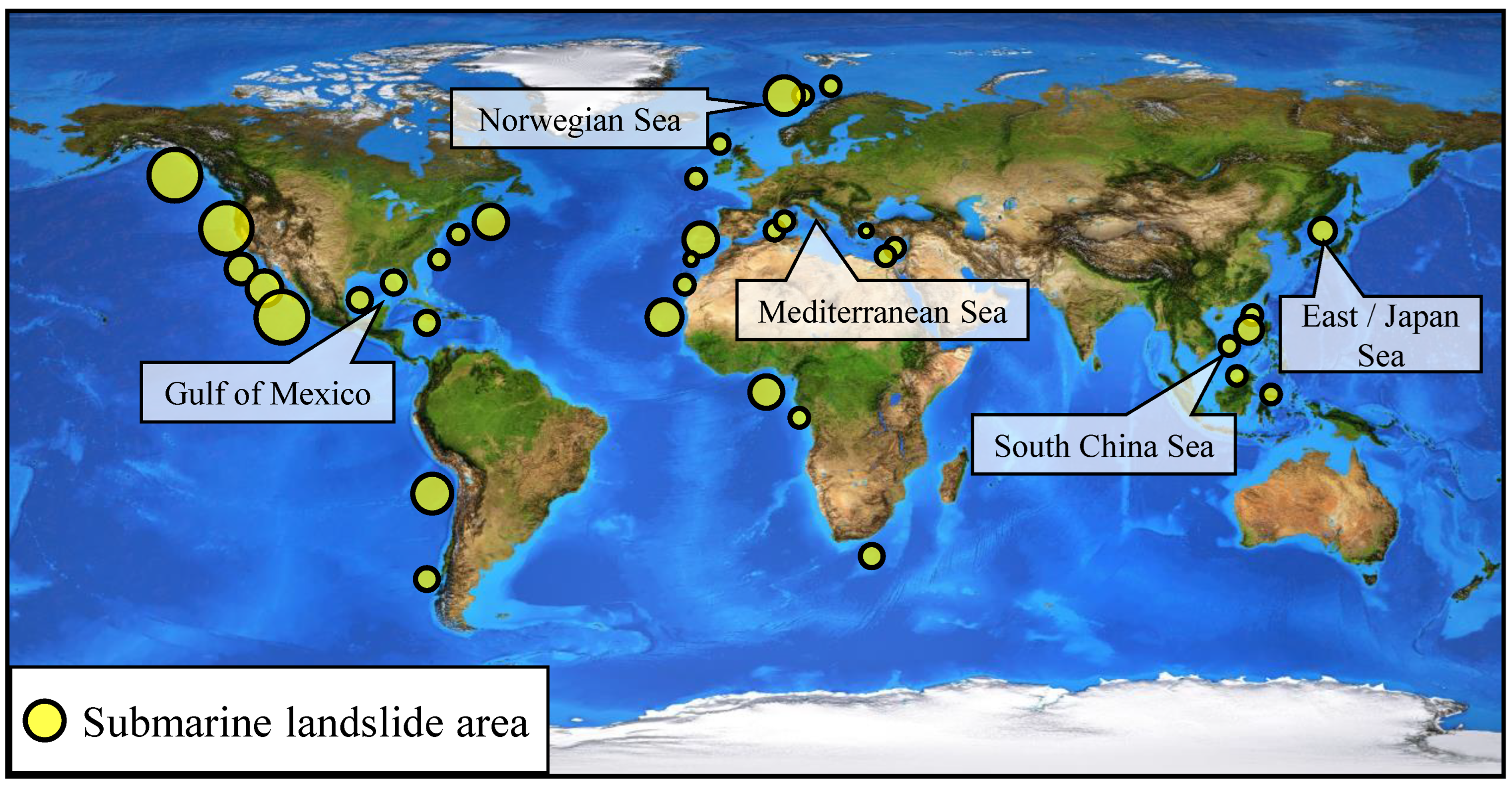
2.1. General Characteristics

There are submarine landslides on virtually all ocean slopes throughout the world [15], such as the Norwegian sea, the Mediterranean sea, the Gulf sea, the Japan sea, and the South China sea. There is a wide variety of locations where submarine landslides can occur, from passive to active continental margins, river-fed pro-deltas, submarine fans, on volcanic island flanks, and glaciated areas and sediment-starved margins (as shown in Figure 1). Submarine landslides may cover more than 10,000 km2 of seafloor and involve more than 1 million cubic meters of sediment. Examples of extremely large and well-known slides include the Storegga Slide [16], the Trænadjupet Slide [17], the Hinlopen Slide [18], and the Sahara Slide Complex [19].
Turbidity currents derived from submarine landslides can travel even further distances, and their deposits can cover large areas within ocean basins. Consequently, submarine landslides are capable of moving hundreds of kilometers downslope. Even more curiously, submarine landslides may occur on slopes as low as 1°, which on land are almost always stable [13]. The U.S. Atlantic continental slope shows examples of submarine landslides with increasing slope angles; as shown in Figure 2a, more than 50% of submarine landslides have slope angles of less than 4°.
According to the statistics and inducing mechanism analysis of 1065 submarine landslide cases worldwide, the trigger factors of submarine landslides can be classified into 15 factors (as shown in Figure 2b). The trigger factors include anthropic (AN), differential compaction (DC), diapirism (DI), earthquake (EQ), erosion (ER), fluid flow (FF), gas (GA), gas hydrates (GH), high sedimentation rates (HS), pore pressure (PP), steepening (ST), sea level (SL), tectonic steepening (TS), volcano development (VD), volcano uplift (VU). Among the above trigger factors, EQ, HS, and DI are the most common triggers for submarine landslides, accounting for 33.5%, 17.6%, and 12.1%, of the total, respectively.

2.2. Submarine Landslide Classification

Submarine landslides have been classified by many researchers, with many fruitful achievements. The various types of submarine landslides that can be involved are summarized by Locat and Lee [7]. They [7] classified the submarine landslides into five categories, including slides, topples, spreads, falls, and flows. Weimert et al. [20] used mass transport complexes (MTCs) to describe the deep-water sediment transport mechanism. Moscardelli and Wood [21] classified MTCs into plate transport complex and turbidity current, and further divided MTCs into slip, slump, and debris flow. Generally, submarine landslides evolve in three stages, as shown in Figure 3. In the initial stages of a submarine landslide (Phase 1), the submarine slope is unstable, the seabed collapses, and the landslide slumps and slides. In the middle stage of a submarine landslide (Phase 2), due to complex water–soil exchanges and long-distance migration, landslides gradually evolve into homogeneous debris flows. In the later stage of a submarine landslide (Phase 3), the water content of the landslide continues to increase. Debris flows and mudflows become turbidity currents and, eventually, heavy water flows as a result of the increased water content.

3. Recent Advances in Submarine Landslide In-Situ Investigations

Compared with conventional land engineering monitoring, marine engineering geological environment monitoring has its unique features, mainly in that the seabed is covered by seawater, which cannot be directly observed, and that it can only be conducted through indirect technical means, which increases the difficulty of research. The dynamic action of seawater is continuous and strong, and the strong action of waves, currents, tides and storm surges brings about various engineering geological problems. The weak sediment makes sampling and observation difficult. Therefore, the offshore engineering geological survey is highly dependent on marine geophysical exploration methods, especially the combination of multiple detection techniques. The submarine landslide in-situ investigation methods include geotechnical monitoring, repeated seafloor surveys, water column imaging, acoustic doppler current profilers (ADCP), mobile sensors, sub-surface timelapse, seismological networks, cabled systems, etc. (as shown in Figure 4).
The deformation monitoring of the sloping seabed is the most direct indicator to reflect the seabed instability. On the one hand, it can provide a reliable basis for the study of the early instability process of landslides (such as sliding velocity, sliding mode, sliding distance, etc.). On the other hand, it can provide an effective early warning for seabed instability caused by offshore oil and gas exploitation. Therefore, geotechnical engineering monitoring of offshore sites is becoming more and more common, such as using in-situ pressure gauges and inclinometers to understand in-situ-specific slope stability issues [23]. In addition, multi-session seafloor surveys using high-resolution multibeam systems reveal the magnitude and frequency of seafloor landslides in multiple systems around the world, such as in deep-water (200–300 m) submarine canyons [23,24,25,26], at active pro-deltas [27,28], in areas with shallow water, and in large displacement conditions [29].
In addition to using the above-mentioned equipment to measure changes in seabed topography, instruments such as ocean bottom seismometers (OBS) can also be used for monitoring, providing information on the timing and nature of slope failure. Mayotte Island, north of the Mozambique Channel, and the Indian Ocean, OBS, were used to monitor the submarine earthquakes [30]. The attenuation of the light waves and electromagnetic waves is serious, and the propagation distance is very limited. Therefore, it is difficult to meet the needs of ocean exploration. In contrast, the propagation performance of sound waves in water is much higher. The acoustic detection equipment developed based on marine acoustic technology has become the “ear” of human beings to detect the underwater world and has become the mainstream of marine detection equipment. For example, multiple moored hydrophones were tried to monitor earthquakes, volcanic activities, various types of tremors, signals related to lava extrusion, and landslides on the seafloor [31]. Shore-based monitoring can provide insight into submarine landslide activity as well. For example, Lin et al. [32] used terrestrial broadband seismic networks to detect offshore landslides in the Kaoping Canyon, offshore Taiwan.
Other major recent advances have been made by the direct measurement of turbidity currents [33,34]. However, monitoring turbidity flows remains somewhat challenging to date because of the logistical challenges of deploying instruments on the deep seafloor, the fact that flows may occur infrequently, and the powerful nature of flows that can damage instruments used for measurements. These challenges mean that turbidity currents have only been measured in a few relatively shallow waters (<2 km) in the world.
Designing a stable monitoring platform and improving the anti-interference ability of sensors will be the problems to solve in the next step of the turbidity flow monitoring of deeper sea areas [35]. However, monitoring large submarine landslides can be more challenging than monitoring turbidity currents because it is not clear where the next landslide will occur, and some landslides have recurrence intervals (>100–1000 s years) [23], which are difficult for most study projects (<5 years). Therefore, even though submarine landslide investigations still face many problems, such as environments and remote settings, positioning accuracy, data resolution, communications, frequency and accuracy of measurement equipment, and measurement equipment recyclability, the most difficult problem to solve is knowing where the next submarine landslide will occur.

4. Recent Advances in Physical Simulation Methods of Submarine Landslides

Submarine landslides occur in complex geological environments. It is almost impossible to capture the whole process of slope failure, slide, slump, debris flow, turbidity current, and the accompanying redeposition of the turbidity current through in-situ investigation. Therefore, laboratory-scale physical simulation experiments are used to discover characteristic physical phenomena and provide valuable experimental data for numerical simulations [36,37].
Flume experiments were conducted to determine the force exerted by a clay-rich submarine landslide on two pipelines by Zakeri et al. [38]. Their experimental results led them to propose a method to estimate drag forces normally directed at a pipeline axis. In order to investigate mudflow flow-front structures, Haza et al. [39] prepared mud models derived from mixtures of 10–35% kaolin and water. Yamada et al. [40] performed a series of sandbox experiments to investigate the mechanical processes involved in the development of submarine landslides. Two types of submarine landslide failure modes were classified in their study, namely, small but frequent slides, and large but less frequent failures of the entire slope. Wang et al. [41] developed a system for simulating a submarine landslide and the relative motion between the submarine landslide and undersea cable. The main part of the test device is a ring water tank made of iron and steel material. The outer diameter of the water tank is 0.9 m, the inner diameter is 0.6 m, and the width is 0.4 m. The impact of the mixture of sediment and water on the cable during the rotation of the tank can be observed through the front transparent plexiglass. Based on the rotating flume test, Deng et al. [42] reproduced the low friction angle motion of underwater debris flow and further analysis revealed that the hydrodynamic pressure generated by the submarine sliding mass impacting the seabed may be the reason for the low friction angle motion of the submarine sliding mass. Based on physical simulations, Liu et al. [43] evaluated the stability of a hydrated seabed and discussed how different geological conditions affect it. By applying pressurized gas to the low-permeability silt layer, they simulated the excess pore pressure caused by the decomposition of hydrate and the physical appearance process of the overlying seabed damage. A study by Wang et al. [44] investigates the impact of submarine telecommunications cables shifting on the seabed. To investigate submarine slope failure caused by overpressure fluid due to gas hydrate dissociation, Nian et al. [45] designed a laboratory-scale device, as shown in Figure 5a. The influences of the thickness of the clay layer and sand layer, undrained strength of clay and injection rate on the submarine landslide failure models are discussed in their study. Based on this, the method of calculating the safety factor of submarine slopes under hydrate decomposition conditions was established, as shown in Figure 5b. Fan et al. [46] designed a flume testing system to simulate the mass transfer process at soil–water interfaces during submarine landslide motions at different velocities. The results show that soil–water interface mass transfer is primarily dependent on soil properties (shear strength, apparent viscosity) and velocity. The influence of sand/clay content on the depositional mechanism of submarine debris flows was investigated by Liu et al. [47] using a submersed flume model. According to the results, swirled-wedge front heads generate high-viscosity slurry flows with greater aspect ratios and rotation radii.
The above experiments were carried out under conventional gravity conditions. The model is often a reduced-scale version of the prototype; as a result, the experimental model has some scaling effects and cannot reflect the real stress environment of the research object [48,49]. As centrifuge models and prototypes have equal stresses, centrifuge modeling is useful for gravitational effects and large-scale modeling in geotechnical materials [50,51]. Boylan et al. [52] carried out geotechnical centrifuge experiments to investigate submarine landslide runout. For observing submarine landslide movement in geotechnical centrifuge model experiments, Gaudin et al. [53] developed a wireless high-speed data-acquisition system. Zakeri et al. [54] investigated the impact forces of submarine landslides on pipelines with uniform velocities by carrying out centrifuge experiments with a centrifugal force of 30 times the Earth’s gravity. Zhang et al. [55] conducted a series of centrifuge experiments to study the evolution of submarine landslides induced by hydrate dissociation. Through their centrifuge experiments, the expansion of cracks, settling zone and the slippage between the over layer and hydrate layer were observed, and the mechanism of submarine landslides induced by hydrate dissociation was revealed. Zhang et al. [56] analyzed the triggering mechanism of submarine landslides using centrifuge modeling experiments. They proposed two mechanisms: accumulation of high pore pressure and associated tensile failure and fracturing in clay and associated shear failure. Zhang et al. [57] developed a newly static liquefaction-triggering actuator to be used in enhanced gravity conditions in a geotechnical centrifuge, investigating the tilting rate effects on submarine landslide processes at various slope steepening rates. They found that as a result of local shear deformations, pore pressure builds up, causing submarine slope instabilities to occur. Among the most important issues in submarine landslide investigation is scaling for the centrifuge modeling of static liquefaction initiation and propagation. Zhang et al. [58] discussed this issue and suggested that an N0.5-fluid should be applied for simulating the onset of static liquefaction of underwater slopes triggered by monotonic loads and that a pore fluid, with a viscosity N times that of water, is required to simulate flow-slide dynamic behavior in a centrifuge, where N is the geometrical scaling factor in centrifuge modelling. Takahashi et al. [59] examined the submarine landslide of sand and silty sand induced by earthquake and liquefaction. They concluded that the debris induced by submarine landslides flowed not with a simple shear but as a clod of soil similar to a fluid, which encouraged high-speed flow.
There has been no model experiment able to simulate and clarify the conditions required for submarine landslides, their gravity flow transition, and sedimentation. Further large-scale flume experiments or drum centrifugal model experiments for simulating submarine landslides are very necessary.

5. Recent Advances in Numerical Simulation Methods of Submarine Landslides

In recent years, numerical simulation methods of submarine landslides have made many advances in the stability analysis of submarine slopes, based on random-field, large-deformation finite-element modelling techniques in submarine landslides, fluid–solid coupling analysis, and marine disaster analysis induced by submarine landslides. Figure 6 shows the current numerical simulation methods for the investigation of the submarine landslide disaster chain.
The uncertainty in input values, such as seismic parameters, soil properties, and hydraulic conditions, may make traditional deterministic methods unreliable for assessing submarine slope stability. Therefore, the enhanced Newmark method [60], Gaussian process regression [61], the Monte Carlo simulation [62] were used to analyze the submarine slope stability. According to Zhu et al. [63], a 3D stochastic finite element model was developed to study the random wave-induced response in a spatially heterogeneous seabed. Based on linear wave theory and Biot’s theory, Zhu et al. [64] analyzed the response of the poroelastic sloping seabed by considering changes in wave length and height when propagated from relatively shallower to deep sea conditions. The above research is mainly aimed at analyzing the stability of submarine slope rather than the evolution process after instability. Dey et al. [65] presented a large-deformation finite-element (LDFE) modelling technique, which incorporated a strain-softening model for the undrained shear strength of marine clay, to model submarine landslides. This technique simulates the development of plastic shear bands and their propagation with displacements of soil mass. Zhang et al. [66] simulated the complete evolution of a submarine landslide from shear band initiation, propagation, and slab failure, and the arrest of shear band propagation is observed through LDFE modelling. To overcome the large computational costs of the LDFE modelling technique, Buss et al. [67] established the energy-balance kinematic method of plasticity theory.
Although the LDFE modelling technique can simulate the large deformation of a submarine landslide, it cannot reflect the motion-evolution process of a submarine landslide [68]. Some numerical studies have focused mainly on replicating run-out characteristics, such as travel distance and velocity. For example, Gauer et al. [69] used the Bingham model to reproduce one of the world’s largest well-known submarine landslides, the Storegga slide. Dong et al. [70] investigated a real case history of a submarine landslide, reproducing the runout of the slides from steep slopes to moderate bases, by using the material point method (MPM). Dong et al. [71] enhanced the conventional depth-averaged method (DAM) algorithm, which is specialized for no-slip bases, to reproduce the phenomenon of block sliding on frictional bases. They assessed the feasibility of the DAM for slides with different sliding modes in terms of runout distances and morphologies. Zhang and Randolph [72] simulated submarine landslides using the smoothed-particle hydrodynamics (SPH) method. Jiang et al. [73] simulated a submarine landslide induced by seismic loading in a methane hydrate-rich zone using coupled computational fluid dynamics (CFD) and the discrete element method (DEM). However, the study only simulated the trigger initiation phase of the submarine landslide. However, almost all the above numerical methods need input information regarding the initial velocity and volume of the failed submarine landslide mass. To overcome this problem, Zhang and Puzrin [74] established a numerical scheme in consideration of the drag force from the ambient water for time-efficient modelling of the entire submarine landslide evolution, covering the pre-failure shear band propagation, slab failure, and post-failure dynamics.
As one of the most destructive marine geological disasters, a submarine landslide often causes the destruction of underwater infrastructures and even catastrophic tsunamis. In recent years, the numerical simulation of submarine landslide impact on underwater pipe and cable systems has achieved rich research results. Dong et al. [75] employed the material point method (MPM) with an enhanced contact algorithm to simulate the submarine landslide impact of a fixed partially embedded pipeline for the first time. Zhang et al. [76] investigated the impact forces exerted by a submarine landslide on laid-on or suspended pipelines at various impact angles θ, based on the Herschel–Bulkley model, using the CFD approach. Nian et al. [77] considered the effect of the low-temperature environment of the seabed on the behavior of marine clay and then investigated the impact of the marine clay on suspended pipelines. According to their findings, 26.0% and 70.3% more force is applied to pipelines at 0.5 °C than at 22 °C when a mudflow impacts them. Li et al. [78] analyzed the interaction between monopile and submarine landslides at different flow heights using a three-dimensional biphasic numerical model. Two modes of interactional forces acting on the monopile (namely, interaction) force with peak value and interaction force without peak value were proposed by their study. Fan et al. [79] designed pipelines with a streamlined contour and investigated the interaction between submarine landslides and streamlined pipelines. Compared with a conventional circular pipeline, streamlined pipelines can reduce the lift and drag force of landslide–pipeline interaction with a maximum lessening percentage of 40% and 66%, respectively. Dutta and Hawlader [80] simulated the lateral penetration of a pipe in a clay block by a CFD approach by incorporating strain-rate and strain-softening dependent models for the undrained shear strength of clay sediment. Guo et al. systematically studied the impact of submarine landslides on pipelines, including the effect of opening and wall boundaries on CFD modeling [81], the effect of pipeline surface roughness on the interaction between pipelines and submarine mudflows [82,83,84], the instantaneous impact of submarine slumps with the shear rate effect on fixed suspended pipelines [85], and the influence of pipeline suspension height on the impact force of submarine landslides on pipelines [86,87]. Tsunamis induced by submarine landslides are also among the marine hazards that have stimulated the attention and concern of researchers during the past decades. However, related research mainly focuses on the evolution of tsunamis, and the simulation of submarine landslides is often simplified. More than 85% of numerical models apply depth-averaged equations to predict the submarine flow behavior through its motion [11]. The influence of more submarine landslide models on surges deserves further study.

6. Discussions on Future Research Directions

The evolution process of submarine landslides has achieved many results. From the perspectives of in-situ investigation techniques, physical simulation, and numerical simulation methods, future research directions of submarine landslides are proposed. Figure 7 summarizes the main points, and the details are discussed in this section.
Due to the uncertainty of the occurrence time of submarine landslides and the high cost of underwater monitoring, the current research on the movement process of submarine landslide is still focused on the tracking of the movement traces and accumulation characteristics after submarine landslides using geophysical exploration technology, while the real-time monitoring of the movement evolution process of submarine landslides is still blank. Therefore, it is urgent to develop an in-situ monitoring system for submarine landslides with long-term service and multi-parameter collaborative observation, so as to realize the long-term observation of various indicators of seabed sediments. In particular, the technique of space-sky-earth-sea can be used to establish a regional network for submarine landslide monitoring and early warning [88]. In addition, advanced methods such as machine learning and big data fusion technology can be fully utilized to conduct an in-depth analysis of the acquired multi-source heterogeneous data [89], which provides technical support for monitoring the kinematic and morphological characteristics of submarine landslides as well as accurate prediction and early warning. As the results obtained by geophysical methods are often multi-solution, while using various acoustic detection methods to identify the geological hazards, the methods of high-quality geological sampling and drilling should be combined to achieve the purpose of correctly identifying the submarine landslide hazards. The comprehensive analysis of geophysical survey data and soil drilling data can greatly enhance the accuracy of engineering geological evaluation. Under ideal conditions, geophysical survey data can provide the extension and thickness of the sedimentary layer, and borehole sampling can provide the physical and mechanical properties of the sediment.
The small-scale flume test is a common method to simulate the evolution of submarine landslides. Although it can simulate the motion of submarine landslides, it is limited by the test situation and cannot reproduce long-distance motion-evolution scenarios, which is far from the real submarine landslide motion. Compared with the flume test, the drum centrifugal test and the rotating water tank test can eliminate the limitations of the test situation and can be used as an important means to study the evolution process of large-scale submarine landslides [90]. However, the water–soil coupling mechanism in the evolution of submarine landslide movement is extremely complex and changeable [91], and the current test method has not quantified the deformation and rupture behavior of the landslide mass caused by the intrusion of environmental water. It is suggested to develop soil–water interface monitoring technology to achieve a quantitative analysis of material exchange and front-end hydroplaning at the water–soil interface during the evolution of submarine landslides. In addition, in view of the lack of in-situ monitoring technology for submarine landslides, it is recommended to reveal the early warning factors of disasters in the evolution of submarine landslides through experiments, such as vibration response, soil pore pressure, and ocean water turbidity.
In terms of numerical simulation methods, the computational fluid dynamics method can be used to simulate large-scale submarine landslide motions. However, this method regards the landslide motion as a single fluid state motion, and it is difficult to consider the microscopic evolution in the process of submarine landslide motion [14,92]. Compared with the CFD method, LDFE, MPM, SPH, and other methods that consider the soil mechanical properties of a submarine landslide, can reproduce the evolution process of a submarine slope from instability to progressive sliding failure [93]. However, the methods are mainly used in the early instability deformation simulation of small-scale submarine landslides due to their high calculation cost. It is worth noting that the above numerical methods are mainly employed in the motion simulation of submarine landslides at the macro level, and they ignore the deformation characteristics of particles inside a submarine landslide mass at the micro level. Therefore, in future numerical simulation research, the macro–micro interconnection effect in the evolution process of submarine landslide motion should be considered, and multi-scale coupled numerical calculation methods, such as CFD-DEM, should be developed to realize the fine simulation of the evolution process of submarine landslide motion. Meanwhile, in order to improve the computational efficiency of multi-scale coupling algorithms, parallel computing architecture or GPU acceleration techniques can be employed to solve this large-scale computational problem [94].

7. Conclusions

We present the technological and methodological advances that have occurred in submarine landslide research in recent years. The following conclusions could be drawn from this study:
According to the in-situ investigation, more than 50% of submarine landslides have slope angles of less than 4°. Earthquakes, high sedimentation rates, and diapirism are the most common triggers for submarine landslides, accounting for 33.5%, 17.6%, and 12.1%, of the total, respectively.
It is urgent to develop an in-situ monitoring system and integrated space-sky-earth-sea technique for submarine landslides, with long-term service and multi-parameter collaborative observation, so as to realize the long-term observation of various indicators of seabed sediments. High-quality geological sampling and drilling should be developed to achieve the purpose of correctly identifying the submarine landslide hazards.
The mechanism of submarine landslide evolution, especially in the water–soil coupling mechanism, needs to be further studied by physical modelling experiments. We recommend revealing the early warning factors of disasters in the evolution of submarine landslides, such as vibration response, soil pore pressure, and ocean water turbidity, through experiments.
Multi-scale coupled numerical calculation methods should be integrated with parallel computing architecture or GPU acceleration techniques to realize the fine simulation of the whole evolution process of a submarine landslide motion.

Author Contributions

Conceptualization, Z.S.; formal analysis, W.N. and X.G.; investigation, M.S., Y.L., A.L., W.X. and X.Z.; writing—original draft preparation, H.W.; writing—review and editing, Z.S., K.W. and L.Z.; project administration, Z.S.; funding acquisition, H.W., K.W. and L.Z. All authors have read and agreed to the published version of the manuscript.

Funding

This research was supported by the National Natural Science Foundation of China under Grant 42207228, 42102313, and 52108356; the Zhejiang Provincial Natural Science Foundation of China under Grant LQ20E090001 and LQ22E090008; the Sichuan Science and Technology Program under Grant 2022NSFSC1060.

Institutional Review Board Statement

Not applicable.

Informed Consent Statement

Not applicable.

Data Availability Statement

Not applicable.

Acknowledgments

The authors gratefully acknowledge the support from the funding listed above. We also appreciate anonymous reviewers who gave comments to revise the paper.

Conflicts of Interest

The authors declare that they have no known competing financial interests with POWERCHINA Huadong Engineering Corporation Limited and Zhejiang Huadong Construction Engineering Corporation Limited, and no known competing financial interests or personal relationships that could have appeared to influence the work reported in this paper.

References

  1. Hampton, M.A.; Lee, H.J.; Locat, J. Submarine landslides. Rev. Geophys. 1996, 34, 33–59. [Google Scholar] [CrossRef]
  2. Masson, D.; Harbitz, C.; Wynn, R.; Pedersen, G.; Løvholt, F. Submarine landslides: Processes, triggers and hazard prediction. Philos. Trans. R. Soc. A 2006, 364, 2009–2039. [Google Scholar] [CrossRef] [PubMed]
  3. Vanneste, M.; Sultan, N.; Garziglia, S.; Forsberg, C.F.; L’Heureux, J.S. Seafloor instabilities and sediment deformation processes: The need for integrated, multi-disciplinary investigations. Mar. Geol. 2014, 352, 183–214. [Google Scholar] [CrossRef] [Green Version]
  4. Hance, J.J. Submarine Slope Stability. Master’s Thesis, The University of Texas at Austin, Austin, TX, USA, 2003. [Google Scholar]
  5. Hsu, S.K.; Kuo, J.; Chung-Liang, L.; Ching-Hui, T.; Doo, W.B.; Ku, C.Y.; Sibuet, J.C. Turbidity currents, submarine landslides and the 2006 Pingtung earthquake off SW Taiwan. TAO Terr. Atmos. Ocean. Sci. 2008, 19, 7. [Google Scholar] [CrossRef] [Green Version]
  6. Brune, S.; Ladage, S.; Babeyko, A.Y.; Müller, C.; Kopp, H.; Sobolev, S.V. Submarine landslides at the eastern Sunda margin: Observations and tsunami impact assessment. Nat. Hazards 2010, 54, 547–562. [Google Scholar] [CrossRef] [Green Version]
  7. Locat, J.; Lee, H. Submarine landslides: Advances and challenges. Can. Geotech. J. 2002, 39, 193–212. [Google Scholar] [CrossRef]
  8. Harbitz, C.B.; Løvholt, F.; Pedersen, G.; Masson, D.G. Mechanisms of tsunami generation by submarine landslides: A short review. Norw. J. Geol. 2006, 86, 255–264. [Google Scholar]
  9. De Mol, B.; Huvenne, V.; Canals, M. Cold-water coral banks and submarine landslides: A review. Int. J. Earth Sci. 2009, 98, 885–899. [Google Scholar] [CrossRef]
  10. Zhu, C.Q.; Jia, Y.G.; Liu, X.L.; Zhang, H.; Wen, Z.M.; Huang, M.; Shan, H.X. Classification and genetic mechanism of submarine landslide: A review. Mar. Geol. Quat. Geol. 2015, 35, 153–163. (In Chinese) [Google Scholar]
  11. Yavari-Ramshe, S.; Ataie-Ashtiani, B. Numerical modeling of subaerial and submarine landslide-generated tsunami waves—Recent advances and future challenges. Landslides 2016, 13, 1325–1368. [Google Scholar] [CrossRef]
  12. Jia, Y.G.; Wang, Z.H.; Liu, X.L.; Yang, Z.N.; Zhu, C.Q.; Wang, X.L.; Shan, H.X. The research progress of field investigation and in-situ observation methods for submarine landslide. Period. Ocean. Univ. China 2017, 10, 61–72. (In Chinese) [Google Scholar]
  13. Huhn, K.; Arroyo, M.; Cattaneo, A.; Clare, M.A.; Gràcia, E.; Harbitz, C.B.; Krastel, S.; Kopf, A.; Løvholt, F.; Rovere, M.; et al. Modern submarine landslide complexes: A short review. In Submarine Landslides: Subaqueous Mass Transport Deposits from Outcrops to Seismic Profiles, Geophysical Monograph, 1st ed.; Kei, O., Andrea, F., Gian, A.P., Eds.; John Wiley & Sons, Inc.: Hoboken, NJ, USA, 2019; pp. 181–200. [Google Scholar]
  14. Nian, T.K.; Shen, Y.Q.; Zheng, D.F.; Lei, D.Y. Research advances on the chain disasters of submarine landslides (in Chinese). J. Eng. Geol. 2021, 29, 1657–1675. [Google Scholar]
  15. Zhu, B.; Pei, H.; Yang, Q. Probability analysis of submarine landslides based on the Response Surface Method: A case study from the South China Sea. Appl. Ocean Res. 2018, 78, 167–179. [Google Scholar] [CrossRef]
  16. Bryn, P.; Berg, K.; Forsberg, C.F.; Solheim, A.; Kvalstad, T.J. Explaining the Storegga slide. Mar. Pet. Geol. 2005, 22, 11–19. [Google Scholar] [CrossRef]
  17. Laberg, J.; Vorren, T. The Trænadjupet Slide, offshore Norway—Morphology, evacuation and triggering mechanisms. Mar. Geol. 2000, 171, 95–114. [Google Scholar] [CrossRef]
  18. Vanneste, M.; Mienert, J.; Bünz, S.J.E. The Hinlopen Slide: A giant, submarine slope failure on the northern Svalbard margin, Arctic Ocean. Earth Planet. Sci. Lett. 2006, 245, 373–388. [Google Scholar] [CrossRef]
  19. Li, W.; Alves, T.M.; Urlaub, M.; Georgiopoulou, A.; Klaucke, I.; Wynn, R.B.; Gross, F.; Meyer, M.; Repschläger, J.; Berndt, C.; et al. Morphology, age and sediment dynamics of the upper headwall of the Sahara Slide Complex, Northwest Africa: Evidence for a large Late Holocene failure. Mar. Geol. 2017, 393, 109–123. [Google Scholar] [CrossRef]
  20. Weimer, P.; Slatt, R.M.; Bouroullec, R. Introduction to the Petroleum Geology of Deepwater Setting; AAPG/Datapages: Tulsa, OK, USA, 2007. [Google Scholar]
  21. Moscardelli, L.; Wood, L. New classification system for mass transport complexes in offshore Trinidad. Basin Res. 2008, 20, 73–98. [Google Scholar] [CrossRef]
  22. Guo, X.S.; Nian, T.K.; Gu, Z.D.; Li, D.Y.; Fan, N.; Zheng, D.F. Evaluation Methodology of Laminar-Turbulent Flow State for Fluidized Material with Special Reference to Submarine Landslide. J. Waterw. Port Coast. Ocean Eng. 2021, 147, 04020048. [Google Scholar] [CrossRef]
  23. Clare, M.A.; Vardy, M.E.; Cartigny, M.J.; Talling, P.J.; Himsworth, M.D.; Dix, J.K.; Harris, J.M.; Whitehouse, R.J.; Belal, M. Direct monitoring of active geohazards: Emerging geophysical tools for deep-water assessments. Near Surf. Geophys. 2017, 15, 427–444. [Google Scholar] [CrossRef] [Green Version]
  24. Hughes Clarke, J.E. First wide-angle view of channelized turbidity currents links migrating cyclic steps to flow characteristics. Nat. Commun. 2016, 7, 11896. [Google Scholar] [CrossRef] [PubMed] [Green Version]
  25. Kelner, M.; Migeon, S.; Tric, E.; Couboulex, F.; Dano, A.; Lebourg, T.; Taboada, A. Frequency and triggering of small-scale submarine landslides on decadal timescales: Analysis of 4D bathymetric data from the continental slope offshore Nice (France). Mar. Geol. 2016, 379, 281–297. [Google Scholar] [CrossRef]
  26. Mountjoy, J.J.; Howarth, J.D.; Orpin, A.R.; Barnes, P.M.; Bowden, D.A.; Rowden, A.A.; Schimel, A.C.; Holden, C.; Horgan, H.J.; Nodder, S.D. Earthquakes drive large-scale submarine canyon development and sediment supply to deep-ocean basins. Sci. Adv. 2018, 4, 3748. [Google Scholar] [CrossRef] [PubMed] [Green Version]
  27. Obelcz, J.; Xu, K.; Georgiou, I.Y.; Maloney, J.; Bentley, S.J.; Miner, M.D. Sub-decadal submarine landslides are important drivers of deltaic sediment flux: Insights from the Mississippi River Delta Front. Geology 2017, 45, 703–706. [Google Scholar] [CrossRef]
  28. Maloney, J.M.; Bentley, S.J.; Xu, K.; Obelcz, J.; Georgiou, I.Y.; Miner, M.D. Mississippi River subaqueous delta is entering a stage of retrogradation. Mar. Geol. 2018, 400, 12–23. [Google Scholar] [CrossRef]
  29. Syahnur, Y.; Jaya, K.A.; Ariseputra, I.P. Geomatics best practices in Saka Indonesia Pangkah Limited (Case Study: Ujung Pangkah Pipeline Integrity). In Proceedings of the 2015 Indonesian Petroleum Association Convention, Jakarta, Indonesia, 16–17 May 2015. [Google Scholar]
  30. Saurel, J.-M.; Jacques, E.; Aiken, C.; Lemoine, A.; Retailleau, L.; Lavayssière, A.; Foix, O.; Dofal, A.; Laurent, A.; Mercury, N.; et al. Mayotte seismic crisis: Building knowledge in near real-time by combining land and ocean-bottom seismometers, first results. Geophys. J. Int. 2022, 228, 1281–1293. [Google Scholar] [CrossRef]
  31. Tepp, G.; Dziak, R.P. The Seismo-Acoustics of Submarine Volcanic Eruptions. J. Geophys. Res. Solid Earth 2021, 126, 2020JB020912. [Google Scholar] [CrossRef]
  32. Lin, C.; Kumagai, H.; Ando, M.; Shin, T. Detection of landslides and submarine slumps using broadband seismic networks. Geophys. Res. Lett. 2010, 37, L22309. [Google Scholar] [CrossRef]
  33. Simmons, S.M.; Azpiroz-Zabala, M.; Cartigny, M.J.B.; Clare, M.A.; Cooper, C.; Parsons, D.R.; Pope, E.L.; Sumner, E.J.; Talling, P.J. Novel Acoustic Method Provides First Detailed Measurements of Sediment Concentration Structure Within Submarine Turbidity Currents. J. Geophys. Res. Oceans 2020, 125, e2019JC015904. [Google Scholar] [CrossRef]
  34. Maier, K.L.; Gales, J.A.; Paull, C.K.; Rosenberger, K.; Talling, P.J.; Simmons, S.M.; Gwiazda, R.; McGann, M.; Cartigny, M.J.; Lundsten, E. Linking direct measurements of turbidity currents to submarine canyon-floor deposits. Front. Earth Sci. 2019, 7, 144. [Google Scholar] [CrossRef] [Green Version]
  35. Clare, M.; Lintern, D.G.; Rosenberger, K.; Hughes Clarke, J.E.; Paull, C.; Gwiazda, R.; Cartigny, M.J.; Talling, P.J.; Perara, D.; Xu, J. Lessons learned from the monitoring of turbidity currents and guidance for future platform designs. Geol. Soc. 2020, 500, 605–634. [Google Scholar] [CrossRef] [Green Version]
  36. Wu, H.; Zheng, D.F.; Zhang, Y.J.; Li, D.Y.; Nian, T.K. A photogrammetric method for laboratory-scale investigation on 3D landslide dam topography. Bull. Eng. Geol. Environ. 2020, 79, 4717–4732. [Google Scholar] [CrossRef]
  37. Nian, T.K.; Wu, H.; Li, D.Y.; Zhao, W.; Takara, K.; Zheng, D.F. Experimental investigation on the formation process of landslide dams and a criterion of river blockage. Landslides 2020, 17, 2547–2562. [Google Scholar] [CrossRef]
  38. Zakeri, A.; Høeg, K.; Nadim, F. Submarine debris flow impact on pipelines—Part I: Experimental investigation. Coast. Eng. 2008, 55, 1209–1218. [Google Scholar] [CrossRef]
  39. Haza, Z.F.; Harahap, I.S.H.; Dakssa, L.M. Experimental studies of the flow-front and drag forces exerted by subaqueous mudflow on inclined base. Nat. Hazards 2013, 68, 587–611. [Google Scholar] [CrossRef]
  40. Yamada, Y.; Yamashita, Y.; Yamamoto, Y. Submarine landslides at subduction margins: Insights from physical models. Tectonophysics 2010, 484, 156–167. [Google Scholar] [CrossRef] [Green Version]
  41. Wang, F.; Dai, Z.; Nakahara, Y.; Sonoyama, T. Experimental study on impact behavior of submarine landslides on undersea communication cables. Ocean Eng. 2018, 148, 530–537. [Google Scholar] [CrossRef]
  42. Deng, J.; Zhang, X.; Shen, S.; Koseki, J. Low friction coefficient (approximately tan1°) of subaqueous debris flow in rotating flume tests and its mechanism. Bull. Eng. Geol. Environ. 2018, 77, 931–939. [Google Scholar] [CrossRef]
  43. Liu, T.; Lu, Y.; Zhou, L.; Yang, X.; Guo, L. Experiment and Analysis of Submarine Landslide Model Caused by Elevated Pore Pressure. J. Mar. Sci. Eng. 2019, 7, 146. [Google Scholar] [CrossRef] [Green Version]
  44. Wang, Y.; Fu, C.; Qin, X. Numerical and physical modeling of submarine telecommunication cables subjected to abrupt lateral seabed movements. Mar. Georesour. Geotechnol. 2021, 39, 1307–1319. [Google Scholar] [CrossRef]
  45. Nian, T.K.; Song, X.L.; Nian, T.K.; Zhao, W.; Jiao, H.B.; Guo, X.S. Submarine slope failure due to overpressure fluid associated with gas hydrate dissociation. Environ. Geotech. J. 2020, 9, 108–123. [Google Scholar] [CrossRef]
  46. Fan, N.; Nian, T.K.; Jiao, H.B.; Guo, X.S.; Zheng, D.F. Evaluation of the mass transfer flux at interfaces between submarine sliding soils and ambient water. Ocean Eng. 2020, 216, 108069. [Google Scholar] [CrossRef]
  47. Liu, D.; Cui, Y.; Guo, J.; Yu, Z.; Chan, D.; Lei, M. Investigating the effects of clay/sand content on depositional mechanisms of submarine debris flows through physical and numerical modeling. Landslides 2020, 17, 1863–1880. [Google Scholar] [CrossRef]
  48. Wu, H.; Nian, T.K.; Chen, G.Q.; Zhao, W.; Li, D.Y. Laboratory-scale investigation of the 3-D geometry of landslide dams in a U-shaped valley. Eng. Geol. 2020, 265, 105428. [Google Scholar] [CrossRef]
  49. Guo, X.S.; Nian, T.K.; Wang, D.; Gu, Z.D. Evaluation of undrained shear strength of surficial marine clays using ball penetration-based CFD modelling. Acta Geotech. 2022, 17, 1627–1643. [Google Scholar] [CrossRef]
  50. Wu, H.; Zhao, W.; Nian, T.K.; Song, H.B.; Zhang, Y.J. Study on the anti-dip layered rock slope topping failure based on centrifuge model test. Shuili Xuebao 2018, 49, 223–231. (In Chinese) [Google Scholar]
  51. Guo, X.S.; Nian, T.K.; Zhao, W.; Gu, Z.D.; Liu, C.P.; Liu, X.L.; Jia, Y.G. Centrifuge experiment on the penetration test for evaluating undrained strength of deep-sea surface soils. Int. J. Min. Sci. Technol. 2022, 32, 363–373. [Google Scholar] [CrossRef]
  52. Boylan, N.; Gaudin, C.; White, D.; Randolph, M.; Schneider, J. Geotechnical centrifuge modelling techniques for submarine slides. In Proceedings of the ASME 28th International Conference on Offshore Mechanics and Arctic Engineering, Honolulu, HI, USA, 31 May–5 June 2009. [Google Scholar]
  53. Gaudin, C.; White, D.J.; Boylan, N.; Breen, J.; Brown, T.; De Catania, S.; Hortin, P. A wireless high-speed data acquisition system for geotechnical centrifuge model testing. Meas. Sci. Technol. 2009, 20, 095709. [Google Scholar] [CrossRef]
  54. Zakeri, A.; Hawlader, B.; Chi, K. Drag forces caused by submarine glide block or out-runner block impact on suspended (free-span) pipelines. Ocean Eng. 2012, 47, 50–57. [Google Scholar] [CrossRef]
  55. Zhang, X.H.; Lu, X.B.; Shi, Y.H.; Xia, Z.; Liu, W.T. Centrifuge experimental study on instability of seabed stratum caused by gas hydrate dissociation. Ocean Eng. 2015, 105, 1–9. [Google Scholar] [CrossRef] [Green Version]
  56. Zhang, J.H.; Lin, H.L.; Wang, K.Z. Centrifuge modeling and analysis of submarine landslides triggered by elevated pore pressure. Ocean Eng. 2015, 109, 419–429. [Google Scholar] [CrossRef]
  57. Zhang, W.; Askarinejad, A. Centrifuge modelling of submarine landslides due to static liquefaction. Landslides 2019, 16, 1921–1938. [Google Scholar] [CrossRef] [Green Version]
  58. Zhang, W.; Askarinejad, A. Centrifuge modelling of static liquefaction in submarine slopes: Scaling law dilemma. Can. Geotech. J. 2021, 58, 200–209. [Google Scholar] [CrossRef]
  59. Takahashi, H.; Fujii, N.; Sassa, S. Centrifuge model tests of earthquake-induced submarine landslide. Int. J. Phys. Model. Geotech. 2020, 20, 254–266. [Google Scholar] [CrossRef]
  60. Yang, Q.; Zhu, B.; Hiraishi, T. Probabilistic evaluation of the seismic stability of infinite submarine slopes integrating the enhanced Newmark method and random field. Bull. Eng. Geol. Environ. 2021, 80, 2025–2043. [Google Scholar] [CrossRef]
  61. Zhu, B.; Pei, H.; Yang, Q. An intelligent response surface method for analyzing slope reliability based on Gaussian process regression. Int. J. Numer. Anal. Methods Geomech. 2019, 43, 2431–2448. [Google Scholar] [CrossRef]
  62. Zhu, B.; Hiraishi, T.; Pei, H.; Yang, Q. Efficient reliability analysis of slopes integrating the random field method and a Gaussian process regression-based surrogate model. Int. J. Numer. Anal. Methods Geomech. 2021, 45, 478–501. [Google Scholar] [CrossRef]
  63. Zhu, B.; Hiraishi, T.; Mase, H.; Baba, Y.; Pei, H.; Yang, Q. A 3-D numerical study of the random wave-induced response in a spatially heterogenous seabed. Comput. Geotech. 2021, 135, 104159. [Google Scholar] [CrossRef]
  64. Zhu, B.; Hiraishi, T.; Mase, H.; Pei, H.; Yang, Q. Probabilistic analysis of wave-induced dynamic response in a poroelastic sloping seabed using random finite element method. Ocean Eng. 2022, 252, 111231. [Google Scholar] [CrossRef]
  65. Dey, R.; Hawlader, B.C.; Phillips, R.; Soga, K. Numerical modelling of submarine landslides with sensitive clay layers. Geotechnique 2016, 66, 454–468. [Google Scholar] [CrossRef]
  66. Zhang, W.; Randolph, M.F.; Puzrin, A.M.; Wang, D. Transition from shear band propagation to global slab failure in submarine landslides. Can. Geotech. J. 2019, 56, 554–569. [Google Scholar] [CrossRef]
  67. Buss, C.; Friedli, B.; Puzrin, A.M. Kinematic energy balance approach to submarine landslide evolution. Can. Geotech. J. 2019, 56, 1351–1365. [Google Scholar] [CrossRef]
  68. Guo, X.S.; Stoesser, T.; Zheng, D.F.; Luo, Q.; Liu, X.; Nian, T.K. A methodology to predict the run-out distance of submarine landslides. Comput. Geotech. 2023, 153, 105073. [Google Scholar] [CrossRef]
  69. Gauer, P.; Kvalstad, T.J.; Forsberg, C.F.; Bryn, P.; Berg, K. The last phase of the Storegga Slide: Simulation of retrogressive slide dynamics and comparison with slide-scar morphology. Mar. Pet. Geol. 2005, 22, 171–178. [Google Scholar] [CrossRef]
  70. Dong, Y.; Wang, D.; Randolph, M.F. Runout of submarine landslide simulated with material point method. J. Hydrodyn. 2017, 29, 438–444. [Google Scholar] [CrossRef]
  71. Dong, Y.; Wang, D.; Cui, L. Assessment of depth-averaged method in analysing runout of submarine landslide. Landslides 2020, 17, 543–555. [Google Scholar] [CrossRef]
  72. Zhang, W.; Randolph, M.F. A smoothed particle hydrodynamics modelling of soil–water mixing and resulting changes in average strength. Int. J. Numer. Anal. Methods Geomech. 2020, 44, 1548–1569. [Google Scholar] [CrossRef]
  73. Jiang, M.; Shen, Z.; Wu, D. CFD-DEM simulation of submarine landslide triggered by seismic loading in methane hydrate rich zone. Landslides 2018, 15, 2227–2241. [Google Scholar] [CrossRef]
  74. Zhang, W.; Puzrin, A.M. Depth integrated modelling of submarine landslide evolution. Landslides 2021, 18, 3063–3084. [Google Scholar] [CrossRef]
  75. Dong, Y.; Wang, D.; Randolph, M.F. Investigation of impact forces on pipeline by submarine landslide using material point method. Ocean Eng. 2017, 146, 21–28. [Google Scholar] [CrossRef]
  76. Zhang, Y.; Wang, Z.; Yang, Q.; Wang, H. Numerical analysis of the impact forces exerted by submarine landslides on pipelines. Appl. Ocean Res. 2019, 92, 101936. [Google Scholar] [CrossRef]
  77. Nian, T.K.; Guo, X.S.; Fan, N.; Jiao, H.B.; Li, D.Y. Impact forces of submarine landslides on suspended pipelines considering the low-temperature environment. Appl. Ocean Res. 2018, 81, 116–125. [Google Scholar] [CrossRef]
  78. Li, R.Y.; Chen, J.J.; Liao, C.C. Numerical Study on Interaction between Submarine Landslides and a Monopile Using CFD Techniques. J. Mar. Sci. Eng. 2021, 9, 736. [Google Scholar] [CrossRef]
  79. Fan, N.; Nian, T.K.; Jiao, H.B.; Jia, Y.G. Interaction between submarine landslides and suspended pipelines with a streamlined contour. Mar. Georesour. Geotechnol. 2018, 36, 652–662. [Google Scholar] [CrossRef]
  80. Dutta, S.; Hawlader, B. Pipeline–soil–water interaction modelling for submarine landslide impact on suspended offshore pipelines. Geotechnique 2019, 69, 29–41. [Google Scholar] [CrossRef]
  81. Guo, X.; Stoesser, T.; Zhang, C.; Fu, C.; Nian, T. Effect of opening and wall boundaries on CFD modeling for submarine landslide-ambient water-pipeline interaction. Appl. Ocean Res. 2022, 126, 103266. [Google Scholar] [CrossRef]
  82. Guo, X.; Stoesser, T.; Nian, T.; Jia, Y.; Liu, X. Effect of pipeline surface roughness on peak impact forces caused by hydrodynamic submarine mudflow. Ocean Eng. 2022, 243, 110184. [Google Scholar] [CrossRef]
  83. Guo, X.; Nian, T.; Stoesser, T. Using dimpled-pipe surface to reduce submarine landslide impact forces on pipelines at different span heights. Ocean Eng. 2022, 244, 110343. [Google Scholar] [CrossRef]
  84. Guo, X.S.; Nian, T.K.; Fan, N.; Jia, Y.G. Optimization design of a honeycomb-hole submarine pipeline under a hydrodynamic landslide impact. Mar. Georesour. Geotechnol. 2021, 39, 1055–1070. [Google Scholar] [CrossRef]
  85. Guo, X.; Liu, X.; Zhang, H.; Li, M.; Luo, Q. Evaluation of instantaneous impact forces on fixed pipelines from submarine slumps. Landslides 2022, 19, 2889–2903. [Google Scholar] [CrossRef]
  86. Guo, X.S.; Zheng, D.F.; Zhao, L.; Fu, C.W.; Nian, T.K. Quantitative composition of drag forces on suspended pipelines from submarine landslides. J. Waterw. Port Coast. Ocean Eng. 2022, 148, 04021050. [Google Scholar] [CrossRef]
  87. Guo, X.S.; Zheng, D.F.; Nian, T.K.; Yin, P. Effect of different span heights on the pipeline impact forces induced by deep-sea landslides. Appl. Ocean Res. 2019, 87, 38–46. [Google Scholar] [CrossRef]
  88. Wang, Z.; Jia, Y.; Liu, X.; Wang, D.; Shan, H.; Guo, L.; Wei, W. In situ observation of storm-wave-induced seabed deformation with a submarine landslide monitoring system. Bull. Eng. Geol. Environ. 2018, 77, 1091–1102. [Google Scholar] [CrossRef]
  89. Lizama, E.; Morales, B.; Somos-Valenzuela, M.; Chen, N.; Liu, M. Understanding landslide susceptibility in Northern Chilean Patagonia: A basin-scale study using machine learning and field data. Remote Sens. 2022, 14, 907. [Google Scholar] [CrossRef]
  90. Hotta, M.M.; Almeida, M.S.S.; Pelissaro, D.T.; de Oliveira, J.R.M.D.S.; Tibana, S.; Borges, R.G. Centrifuge tests for evaluation of submarine-mudflow hydroplaning and turbidity currents. Int. J. Phys. Model. Geotech. 2020, 20, 239–253. [Google Scholar] [CrossRef]
  91. Shi, C.; An, Y.; Wu, Q.; Liu, Q.; Cao, Z. Numerical simulation of landslide-generated waves using a soil–water coupling smoothed particle hydrodynamics model. Adv. Water Resour. 2016, 92, 130–141. [Google Scholar] [CrossRef] [Green Version]
  92. Nian, T.K.; Wu, H.; Takara, K.; Li, D.Y.; Zhang, Y.J. Numerical investigation on the evolution of landslide-induced river blocking using coupled DEM-CFD. Comput. Geotech. 2021, 134, 104101. [Google Scholar] [CrossRef]
  93. Zhang, W.; Puzrin, A.M. How small slip surfaces evolve into large submarine landslides—Insight from 3D numerical modeling. J. Geophys. Res. Earth Surf. 2022, 127, e2022JF006640. [Google Scholar] [CrossRef]
  94. Dong, Y.; Grabe, J. Large scale parallelisation of the material point method with multiple GPUs. Comput. Geotech. 2018, 101, 149–158. [Google Scholar] [CrossRef]
Figure 1. Regional distribution of main areas for submarine landslides. Modified from [15].
Jmse 10 01728 g001
Figure 2. Characteristics of submarine landslides. (a) Slope angles of submarine landslides; (b) Trigger factors of submarine landslides.
Jmse 10 01728 g002
Figure 3. Overview of the stages in the evolution of a submarine landslide. Modified from [13,22].
Jmse 10 01728 g003
Figure 4. Conventional and emerging geophysical tools for submarine landslide in-situ investigations. Modified from [23].
Jmse 10 01728 g004
Figure 5. Investigation of submarine landslide induced by hydrate dissociation. (a) Schematic diagram of the experimental device; (b) Mode of submarine landslide induced by hydrate dissociation. Modified from [45].
Jmse 10 01728 g005
Figure 6. Current numerical simulation methods for investigation of submarine landslide disaster chain.
Jmse 10 01728 g006
Figure 7. Future research directions of submarine landslides.
Jmse 10 01728 g007
Table 1. Summary of existing reviews regarding submarine landslides in recent years.
ReferencesResearch ContentKey ConclusionsHighlights of the Review
Locat and Lee [7]Summarized the causes, classification, characterization, geotechnical investigation methods, and mechanics of submarine landslides.A major challenge is the integration of submarine landslide movement mechanics in an appropriate evaluation of the hazard.A comprehensive review of submarine landslides.
Harbitz et al. [8]Analyzed the mechanisms of tsunami generation by submarine landslides.Submarine landslide volume, initial acceleration, maximum velocity, and possible retrogressive behavior are important to the characteristics of the resulting tsunami.The focus is on tsunamis induced by submarine landslides.
De Mol et al. [9]Analyzed the relation between cold-water coral bank development and submarine landslides.No general and direct relationship exists between submarine landslides and cold-water coral banksThis paper focuses on the trigger factors of submarine landslides.
Zhu et al. [10]Summarized the classification of submarine landslide typesThe classifications of submarine landslides are becoming more and more deep, detailed, and generalized.This paper focuses on the classification of submarine landslide types.
Yavari-Ramshe and Ataie-Ashtiani [11]Reviewed numerical studies on submarine landslide-generated waves.The conceptual, mathematical, and numerical structures of submarine landslide-generated waves are comprehensive analyses.The focus is on the numerical methods for simulation the tsunamis induced by submarine landslides.
Jia et al. [12]Reviewed the in-situ observation methods of submarine landslides.The research on in-situ testing method of submarine landslide is still in its early stage and needs to be further studied.This paper focuses on field investigation and in-situ observation methods for submarine landslides.
Huhn et al. [13]Reviewed triggering mechanisms, monitoring methods, and hazards and risks of submarine landslides.In-depth study of submarine landslides requires more interdisciplinary approaches.This paper’s emphasis is on the emerging needs in future landslide research.
Nian et al. [14]Reviewed the advances in the chain disasters of submarine landslides.The physical and numerical simulation techniques of submarine landslide movement evolution still need further study.This paper focuses on the simulation methods of chain disasters of submarine landslides.
Publisher’s Note: MDPI stays neutral with regard to jurisdictional claims in published maps and institutional affiliations.

