Article

Diversity of Cropping Patterns and Factors Affecting Homegarden Cultivation in Kiboguwa on the Eastern Slopes of the Uluguru Mountains in Tanzania

International Corporation Center for Agricultural Education, Nagoya University, Nagoya-shi, Chikusa-ku, Furocho 464-8601, Japan
*
Author to whom correspondence should be addressed.
Agriculture 2018, 8(9), 141; https://doi.org/10.3390/agriculture8090141
Submission received: 4 June 2018 / Revised: 29 August 2018 / Accepted: 29 August 2018 / Published: 13 September 2018
(This article belongs to the Special Issue Biodiversity of Vegetable Crops, A Living Heritage)

Abstract

:
This study investigated what kind of diversities of cropping patterns observed in home gardens distributed on the eastern slopes of the Uluguru Mountains in central Tanzania, and how the diversity come into occurred. The major focus included the differences in ecological environment due to elevation, the impacts of the Ujamaa policy, and the characteristics of household members. Participatory observation with a one year stay in the study village was conducted to collect comprehensive information and to detect specific factors about formation of diversity cropping patterns of homegardens. The features of cropping patterns of the homegardens were assessed in an area distributed at altitudes of 650–1200 m. Many of the tree crops in this village originated from outside regions around the period of Tanzanian independence, and their cultivation spread throughout the village after the implementation of the Ujamaa policy. At present, village districts with many distributed homegardens with numerous tree crops are those that were confiscated from clans by the village government at the time of the Ujamaa policy and then redistributed to individuals. Cultivation of trees crops was very few at altitude of 900 m or more, because of cultivation characteristics of tree crops in this village were suitable for low altitude. In addition, since homegardens are considered to be abandoned for one generation only, their cropping patterns tended to easily reflect the ages and preferences of the members of the households living on them. The cropping patterns of the homegardens differed remarkably even between neighboring households owing to the cumulative effects of these multiple factors. Analysis using an inductive method—considering the background against which the phenomenon becomes evident after collecting the information from the target area in this manner—is thought to lead to an essential understanding.

1. Introduction

Homegardens have a complex and diverse cropping pattern similar to the agroforestry where trees and herbaceous crops grow together. Homegarden agroforestry systems in the tropics are known for their structural complexity and diversity in crop and other plant species [1]. Studies focused on variations in the diversity of homegardens have revealed that the diversity is often not static, but changes in response to socio-economic dynamics [1,2,3]. Homegardens are a time-tested local strategy that are widely adopted and practiced in various circumstances by local communities with limited resources [4]. Consequently, homegardens should not be interpreted as a generic agro-forestry system with uniform diversity characteristics, but rather as involving different types of features with respect to species diversity [1,3]. Therefore, a prerequisite for obtaining a precise understanding of the relation between species diversity and homegarden sustainability is that a better insight is obtained into the different dimensions of homegarden diversity at spatial and temporal scales and at the level of both species and functional groups “[5]”).
The current stance adopted by developing countries on agricultural development research employs a deductive approach to provide the necessary supports based on modern agricultural sciences, which in the phenomena such as cropping pattern are generally analyzed from the environmental or economic viewpoint [6,7]. Agricultural technical supports that conducted in developing countries attempt to disseminate agrarian technologies or new varieties, which were developed based on the modern agricultural science [7]. Population in developing countries has predicted to increase, especially, Africa’s growth rate is said to be the highest. Therefore, from the viewpoint of food security, the devising methods, and methods appropriate for African agriculture are indispensable. However, it appears that the modern agricultural technologies are not widely accepted by the rural people in Africa, as they are not adapted to unique agriculture [8]. It is essential to consider the methods of rural development or agricultural technology support to be accepted [8]. In this regard, it is vital to provide necessary support based on the actual situation of the target area. However, at present, there is a little information to understand the essence of agriculture in rural areas in developing countries, especially in Africa.
Cultivation of the homegardens in Africa were focused from multiple point of view such as food condition [9], economical [10], environmental [11], and as a place to preserve diversity of crops [12].
This study aimed to provide information about a time-tested local strategy of homegardens that is obtained from different spatial and temporal dimensions and diversity to provide information to deepen the understanding of Africa’s homegarden. Most previous studies on homegardens in eastern Africa have commonalities in their crops combination; most of them cultivate Musaceae crops such as banana (Musa spp.) or Ethiopian banana (Ensete ventricosum (Welw.) Cheesman) and coffee (Coffea arabica/robusta L.) [5,13]. Ethiopian banana and banana are cultivated as their staple food crops and coffee is cultivated as a commercial crop in each area. Even when they mention the diversity in cropping patterns of their homegardens, these combinations of crops are observed commonly within an area [14,15,16,17,18]. However, extreme differences were observed in cropping patterns in homegardens in Kiboguwa Vill.age located on the eastern slopes of the Uluguru Mountains in central Tanzania. In some homegardens, many kinds of tree crops—for example, African breadfruit (Treculia Africana Decne.), coco palm (Cocos nucifera L.), jackfruit (Artocarpus heterophyllus Lam.), cinnamon (Cinnamomum zeylanicum J.Presl), etc.—are cultivated together. On the other hand, in another homegarden, herbaceous crops such as maize or common bean or banana dominate. Sometimes, the types of crops which are observed in homegardens are quite different even among adjacent homegardens.
This paper focuses on the diversity of the cropping pattern observed in the homegardens in the target village. After clarifying how the cropping pattern is diverse, the factors behind the diversity in cropping patterns in homegardens in the target village are comprehensively considered and described; such factors include ecological difference due to the elevation of the mountain, the historical land tenure policy and differences in household members, etc. The method of participatory observation accompanied with long term stay is a powerful method as a method for collecting information unique to the targeted area, and in this research, various information of the target area is collected based on field work and various information tried to explain why planting is seen from multiple backgrounds peculiar to the area.

2. Materials and Methods
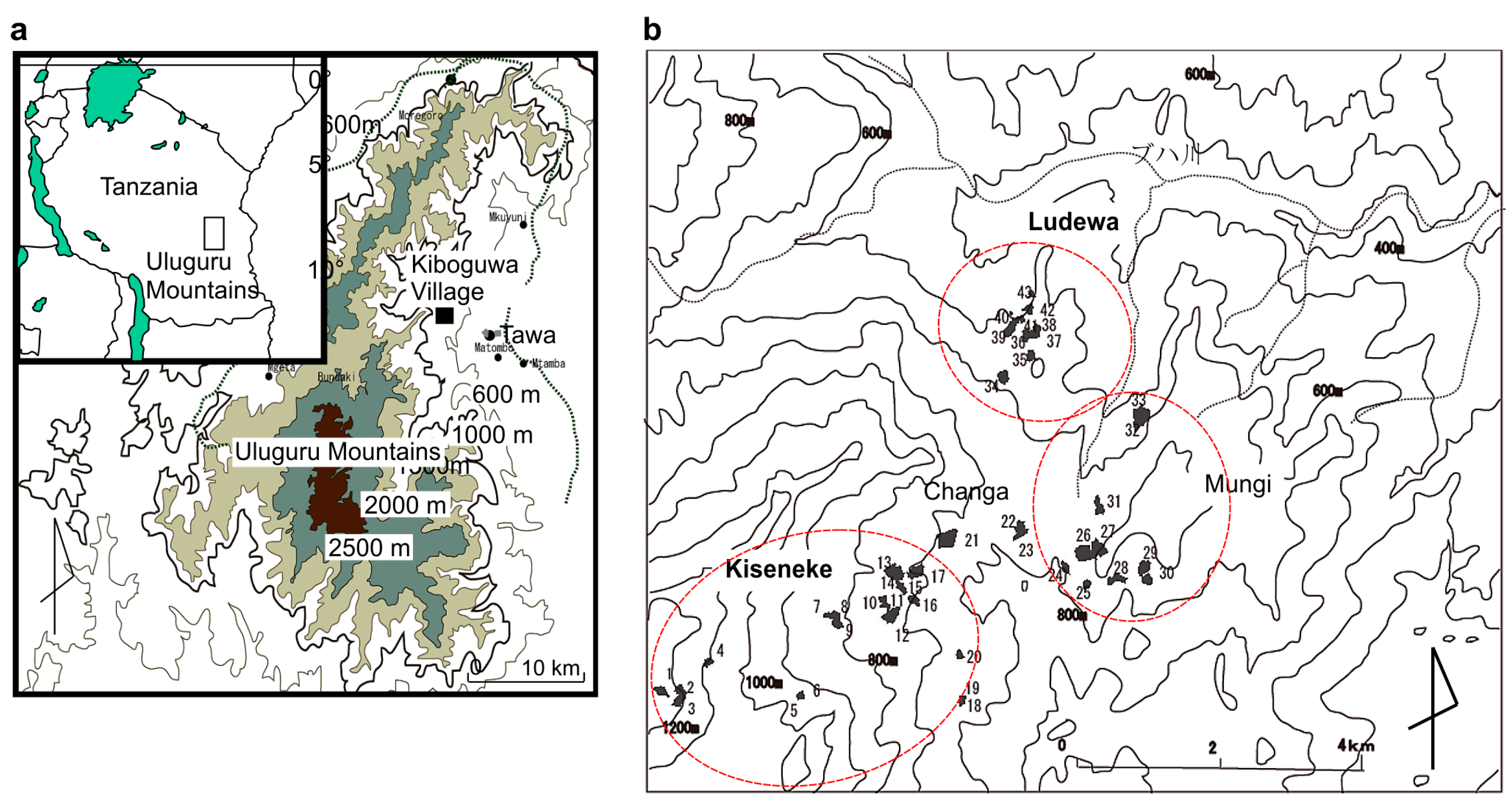
2.1. Study Area

Kiboguwa Village (E: 37°40′50–37°42′20, S: 6°59–7°00′35), located in central Tanzania in the Uluguru Mountains (Figure 1a,b), extends over approximately 55 km north to south and 30 km east to west. The eastern slopes of the mountains where the study was conducted receive abundant rainfall; hence, many tree crops and commercial crops such as banana are commonly cultivated in the villages located on these slopes [19]. The elevation of Kiboguwa Village is approximately 800 m (Figure 1b), suggesting that it is also central regarding the elevations of villages found around the eastern slopes (between 300 m and 1500 m). The villagers’ homes and fields are located at elevations from 600 m to 1200 m; practically all of the land, including the slopes, is used for cultivation.
Two types of land use patterns were observed in Kiboguwa village, namely cultivated lands (primarily) and homegardens. The cultivated lands (Kumugunda, in the Luguru language) are used for the cultivation of staple food crops, such as maize (Zea mays L.), rice (Oryza sativa L.), and cassava (Manihot esculenta Crantz) [20]. Homegardens are called Ditzulala by the local people in Kiboguwa village. According to the villagers, this corresponds to the word Jalala in Swahili. However, Jalala refers only to a place where refuse from a house is discarded, whereas Ditzulala is used to refer to a homegarden. Currently, in a Ditzulala, spice crops such as cinnamon, pepper (Piper nigrum L.), and cardamom (Elettaria cardamomum (L.) Maton) grow together with tree crops such as African breadfruit, coconut, and coffee densely distributed around houses, creating a thick forest landscape. The villagers also plant herbaceous crops, including banana, maize, and common bean (Phaseolus vulgaris L.). Another land use pattern is the cultivated lands (Kumugunda, in the Luguru language) which are used for the cultivation of staple food crops—such as maize, rice, and cassava—which are distributed outside the homegardens.
In the Uluguru Mountains, the present social structure is centered on the Matrilineal clans of the Luguru people who live throughout the mountain range and greatly influence the land tenure in the region. According to the customary land tenure system of these people, male and female clan members have equal usufructuary rights from birth to death to cultivate the clan’s land [21]. However, individuals are not recognized as owners of the land, and they do not have the property rights. Conversely, the ownership rights for perennial crops that last for many years, such as tree crops, belong to the person who planted them. This scenario creates the possibility of inheritance of the perennial crops as the property of children who are not members of the land’s clan. Therefore, people with usufructuary rights for the land owned by their clan may differ from the owners of tree crops planted on that land. Thus, under the original land tenure system, tree crops and other perennial crops are recognized as difficult crops to plant on the clan’s land due to the need to first obtain the consent of the clan members [21]. Nonetheless, at present, many tree crops that form a thick forest landscape are noted in the homegardens from the study region, but growing tree crops—i.e., perennial crops—are difficult to find on clan land [22]. In the Kiboguwa village, tree crops or perennial crops (including banana) are rare on the Kumugunda. On the other hand, the cultivation of perennial crop and tree crops has been observed in most homegardens of the village [20].
Recent studies of the Kiboguwa village already mention the role of the homegardens in the food security of the staple food crops [20] and the diversity of cropping patterns that was focused on the commercial crops [23]. There were many crops of secular life in commodity crops. Spice crops such as cinnamon and cardamom had a limited harvesting period, so they were used as a product crop to earn extra money. On the other hand, since bananas are obtained throughout the year, they were used as a stable income source. Bananas at the residence site were sometimes consumed boiled, but the earnings obtained from banana sales also played an important role in complementing self-sufficient crops [20]. This was caused by the low and insufficient productivity of the two main types of cereals, maize and rice, which were produced on the slopes outside the homegardens. Many households have been sold bananas grown in homegardens to compensate for cereal food shortages. Therefore, as a commercial crop, it was found that bananas play a vital role in achieving food security for the villagers [20].
According to the 2002 census, the population of Kiboguwa Village was 1402 (225,857 people in the Morogoro Region according to the 1988 census; in 2002, it reached 263,012 people; and in 2012, 286,248 people). The annual rate of population increasing from 1988 to 2002 was 1.17%, whereas from 2002 to 2012 it reached 0.88%, indicating that the population hardly increased. Therefore, a dramatic increase in the number of village households due to the population increase might not have occurred during the survey period (2004 to 2007) until 2013 (Data source: http://www.nbs.go.tz/). The survey includes seven village districts that cover the slopes of the ridge running through the center of the village at elevations of 800 m to 1400 m as well as the valleys. The difference in elevation is the largest in the Kiseneke village district. Between the Changa village district and the Buha River, Nbure, Ludewa, and Mungi village districts are located on the north side. The Mungi village district occupies an extensive range along the boundary with the tower of a neighboring village situated to the south.

2.2. Participatory Survey

A survey of participant observations accompanied by a long-term stay in the study area was carried out. The participant observation method was employed for the data analysis in this empirical research. This method is commonly used in anthropological studies [24]. The author lived with the farmers at their houses to obtain first-hand information and to understand actual situations on such factors as their lifestyle, food consumption, agricultural practices, etc. The author (Yamane) resided in Kuboguwa village for a total of one year as follows: three months from July to October 2004; four months from June to September 2005; one month in December 2005; two months from December 2006 to January 2007; and two months from June to July 2008. The cropping patterns of the study area and the factors—such as the history of homegardens, geography, climate, land use policies, and cultural behavior on the land use of this area—which were thought to affect the diversity of cropping patterns in the homegardens were studied. In this study, we conducted questionnaire surveys to collect quantitative data. The questionnaire was structured which corresponds to the information on the actual condition of the target area based on the qualitative information obtained from the participant observation. The causal relationship between the phenomena such as cropping pattern of the homegardens and the factors influencing on it were discussed. The author revisited the study village in December 2017, and it was confirmed that the agricultural landscape had not changed drastically.

2.3. Measurement of Cropping Patterns

A total of 254 households were identified among the four village divisions, via images captured by the QuickBird satellite sensor on 4 October 2005. A survey questionnaire was carried out in September 2005 among 43 randomly selected households in the four divisions of Kiboguwa village, to gather information about the homegarden. The number of households surveyed in the village divisions was 23 in Kiseneke, 3 in Changa, 10 in Mungi, and 10 in Ludewa. From December 2006 to January 2007, the same survey questionnaire was applied for a total of 84 households. The village council members in four districts were questioned regarding how they obtained the land for home gardening.
The location, size, and elevations of the homegardens were measured using a geographical information system (GPS; eTrex Legend; Germin Ltd. (Olathe, KS, USA)) in July 2005. A total of 43 households distributed within four village districts—20 households from Kiseneke village district, 10 households from each of Mungi and Ludewa village districts, and 3 households from Changa village district—were surveyed and the varieties of crops and the number of each crop were recorded separately. At the same time, a schematic diagram of the homegardens for these 43 households was developed (Figure 2). The cropping patterns were reproduced by using computer software, ArcView3.1 (ESRI, Redlands, CA, USA) to measure the exact size of the area of each crop variety. The heights of conventional tree crops were measured using a gauge.
The quantity of each crop variety was determined by using the schematic diagram that reflected the number of individual plants for herbaceous crops and the area size covered by each tree. The number of different plants such as maize and cassava could not be counted individually due to the high density of plants. In this regard, the quantity of the plants grown was expressed morphologically. The vine-like plants, such as sweet potato, were estimated by the ratios of the areas occupied by those plants. The sizes of the planted area of the crops mentioned above were obtained using the GPS data. The complexity of cropping patterns was expressed using Simpson’s diversity index [25] and the value of the exponent (D = (Σsin/N) 2) of Simpson were calculated.
In one home garden, there are many cases where a nuclear family, that is, a family mainly consisting of a couple and unmarried children live. The heads of the household of the four village districts were interviewed to obtain personal information such as age, place of birth, marital status, and the way in which they came to own the homegardens. In the case of the heads not knowing such information, other family members were interviewed. Therefore, in this paper, the husband of the nuclear family was regarded as ‘household head’. In the cases where the male head of household was not present, the head woman of the household was the eldest female. Thus, the data were collected covering all households distributed in the four village districts.

2.4. Measurements of Temperature at Different Elevations

In September 2005, humidity and the temperature at elevations of 1050, 750, and 650 m in Kiboguwa Village were measured using metrological equipment (HOBO Pro RH, Klima Tech Co., Ltd., Tokyo, Japan).

2.5. Collection of Historical Information of Homegarden Crops

Some of the village elders were interviewed from July to October in 2004 to gather information such as the transition in agriculture, crop varieties, and the history of the introduction of tree crops in particular. Interviewed people consisted of 12 clan heads, and they were between 60–80 years old. The elders were interviewed to confirm, to support, and to understand further detailed information of the previous surveys.

2.6. Questionnaire Survey

From December 2006 to January 2007, the same questionnaire survey was conducted for total 84 households; 21, 23, 18, and 22 households in the village divisions of Kiseneke, Changa, Mungi, and Ludewa, respectively. In the questionnaire of 2006 and 2007, some questions were included to obtain information about family member of the households and methods to get cultivated land and homegardens.
A total of 254 households were detected in the four village divisions when it was counted via the satellite image of Quick bird, which was taken on 4 October 2005. Our sample size was 84 households. Therefore, in this survey, approximately 33% households in four village divisions were targeted.

3. Results

3.1. Diversity of the Cropping Patterns in the Village Homegardens

The homegardens of Kiboguwa village presented extremely diverse cropping patterns. We classified the cropping patterns using five elements: (1) homegarden area; (2) ratio of crop cultivated area; (3) the varieties of crops planted in the cultivated area; (4) heights of the tree and herbaceous crop varieties; and (5) the diversity index which shows the crop diversity.
The homegarden area and the ratio of cultivated area: The area of homegardens belonging to the 43 households surveyed varied largely. The widest and narrowest homegarden areas ranged between 1.84 and 0.15 acres respectively, with an average of 0.66 acres. However, many households had sufficiently wide homegardens for cultivation (Table 1).
The range of the cultivated area ratios for four households (numbers 5, 18, 19, and 43) with a cultivated area of around 0.2 acres ranged from 39.9% to 82.9%. A household (number 38) with a homegarden smaller than the average (0.32 acre) planted crops on only 20% of its total area; in another household (number 27) with a large homegarden of 1.4 acres, the crops occupied nearly 80% of its total area. Thus, the ratios of cultivated area were thought to be not necessarily influenced by the size of the homegarden area. Therefore, the cropping pattern consisted of a characteristic of the relative use of the space of homegardens, and varied according to four factors: (i) ratio of crop cultivated area in homegardens; (ii) the varieties of crops planted in the crop cultivated area; (iii) heights of the tree and herbaceous crops varieties; and (iv) the diversity index. Based on those characteristics, we classified the cropping patterns in the homegardens of the 43 households.
First, according to the plant’s growth habit, we divided the crops planted in the homegardens as tree crops and herbaceous crops, as shown in Table 1. Then, we evaluated the ratios of the areas occupied by the respective crops. Next, the rates of cultivated area occupied by the crops (3a), and (3b) in each household’s homegarden were plotted (Table 1). The ratios of (3a) and (3b) differed remarkably depending on the household (Table 1). Moreover, we divided the cropping patterns of tree crops (3a) into four types according to the area of the homegardens occupied by the crops: high (type-I, ≥70%), medium (type-II, 40–69%), low (type-III, 10–39%), and very low (type-IV, <10%).

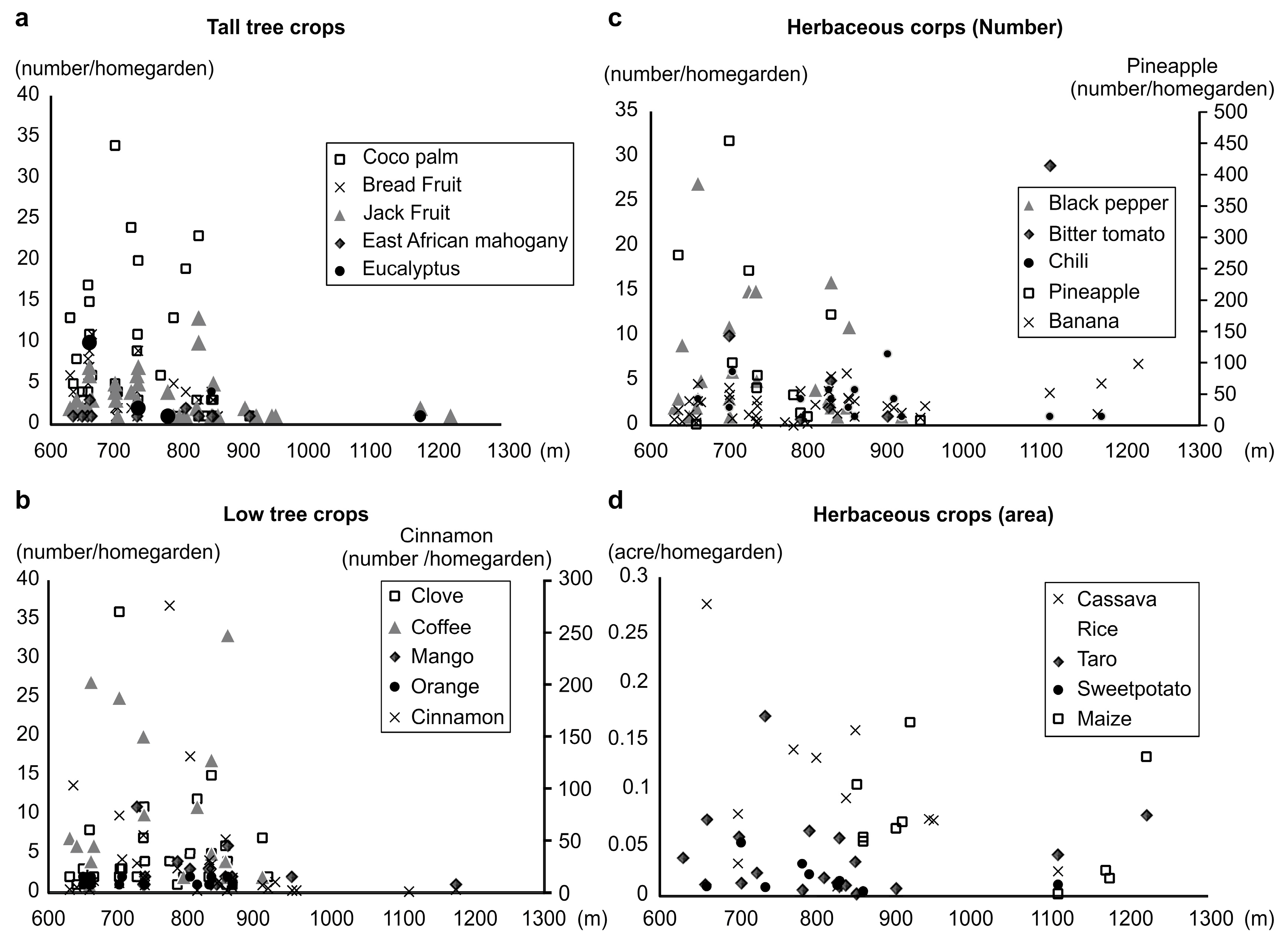
3.2. Crop Grouping Based on Their Heights

Since the heights of tree crops differ remarkably depending on the variety and individual tree type, we divided the 23 varieties of tree crops into two groups: tall and short. The tall trees are 10 m or above and the short trees are less than 10 m (Table 2). Since herbaceous crops do not generally differ considerably in height by individual plant or variety, they were classified according to the average height of each crop. Herbaceous crops with a height of 5 m or more were classified as tall herbaceous crops (Table 3).
We report homegardens dominated by tree crops (type I and II). The ratios of the areas occupied by the five crop groups for each household classified according to height are shown in Table 1, Table 2 and Table 3. In cropping type I, tree crops covered 70% or more of the cultivated area within the homegarden; many households mainly planted tall trees such as coconut and jackfruit. An exception was the homegarden of household number 29, which primarily cultivated small trees, including clove and cinnamon. In cropping type II, tree crops covered 40% to 69% of the cultivated area; many households mostly cultivated tall trees, except household numbers 42 and 17, which cultivated more small trees. Homegardens classified as type III and IV were characterized by the dominance of herbaceous crops. Here, the households preferred more herbaceous crops than tree crops, and the heights of crops varied (Table 1). Banana crops (a tall herbaceous crop) dominated four homegardens (household numbers 13, 34, 2, and 12), whereas the other seven homegardens (household numbers 36, 40, 15, 11, 8, 9, and 1) presented a dominance of medium herbaceous crops such as maize, cassava, and taro. Common bean and rice plants dominated four homegardens (household numbers 2, 9, 7, and 4). Many households presented diversity index values higher than 0.7; others only reached values below 0.5. Therefore, we classified the homegardens with a diversity index below 0.5 as type V. Five households (numbers 25, 5, 6, 3, and 18) belonged to that category, with an average number of 7.4 crop species per household, remarkably smaller than the other households. In the homegardens of this type, which were characterized by a low level of diversity, we observed a shared tendency among households of cropping specific crops in a manner similar to a monoculture (Table 1). Household number 25 cultivated cinnamon; household numbers 5 and 6, cassava; and household number 18, pineapple (Ananas comosus (L.) Merr.) in the form of a monoculture.

3.3. Distribution of Households According to Cropping Patterns

The cropping pattern changes with the elevation of households. Many homegardens of type I located at low elevations, mostly cultivated tree crops (Table 1). The relationship between elevation and the quantity of each crop was investigated, and the results are shown in Figure 3a–d. Type IV households located at high elevations (>850 m) hardly cultivated any tree crops, except household number 18. Type I homegardens were located in Ludewa and Mungi village districts, whereas type IV homegardens occurred only in the Kiseneke village district. Type II and III homegardens were distributed at elevations within the interval between types I and IV.

3.4. Differences in Temperature at Each Elevation

The annual rainfall in the investigated village ranged between 1800–2000 mm [26]. On the eastern slopes, rainfall rarely limited crop growth even at comparatively low elevations; hence, differences in rainfall, but not in temperature, due to elevation strongly affected the variability of cultivated crops.
From September 2004 to January 2007, we registered average temperatures of 23.3, 22.2, and 21.1 °C at the elevations 650, 750, and 1000 m in Kiboguwa Village, respectively. At these three elevations, the temperature increased by 1.1 °C with decreasing elevation with no major differences observed across the years. Rice plant cultivation began in June and July when the lowest temperatures are recorded. The average lowest temperatures during this period were 15.5 °C at 1000 m; 15.8 °C at 750 m; and 17.3 °C at 650 m. Temperatures close to 15 °C damage rice plants, which we observed at an elevation of 1000 m. The average temperatures increase during the period from December to February, with the highest daily temperature of 33.1 °C, which is not considered high enough to potentially damage crops.

3.5. Characteristics of the Crops at Different Elevations

The temperature at low elevations is suitable for growing tree crops, except coffee. When we compared satellite images obtained in 2013 (Figure 4c) with those obtained in 2005 (Figure 4b), we did not observe any significant changes in the forest landscape at the site regarding its location, size, or condition. Additionally, we did not observe any major changes in the uses of land outside the homegardens. These findings suggested that, from 2005 onward, no climate changes occurred that could impact the cropping patterns within this region, and the phenomenon described in this study might continue to be observed even at present.
Considering the quantity cropped for each elevation (Figure 3a,b), although some households have nearly 70% of their cropping area occupied by cinnamon and coconut, the ratios of these cropping areas remarkably drop when the elevation approaches 800 m. Coconut is not cultivated at elevations of 900 m and above (Figure 3a). The cultivation of cinnamon extends to elevations of 1000 m and above (Figure 3b), but at a smaller proportion; the cropping quantity further decreases at low elevations. The same tendency occurred for clove, coffee, breadfruit, jackfruit, and East African mahogany (Khaya anthotheca) as shown in Figure 3a,b.
Regarding the cultivation of herbaceous crops at different elevations, we observed the cultivation of maize limited to homegardens located at elevations equal to or higher than 850 m (Figure 3d). Common bean is cropped as a monoculture in sloping fields, and people from Kiboguwa often planted it at elevations of 900 m to 1000 m. Legumes cultivated in this village are better adapted to the environment [27]. Maize and common bean grow together in the homegardens distributed at elevations of 800 m and above. Conversely, cassava and rice plants are cropped at an elevation belt different from that of maize and common bean (Figure 3d). They are frequently cultivated together on sloping fields.
Since the cultivation characteristics of maize, rice, and cassava differ remarkably depending on the variety of each crop, the order of elevation belts in which they are cultivated also relies on the combination of varieties selected. However, in the mountain regions where both maize and rice plants can be cropped together, rice plants are generally cultivated at a lower elevation belt.

3.6. Variations in the Cropping Patterns of Households Distributed at Elevations of 900 m and Below

In addition to the differences in cropping patterns according to elevation, major differences existed in homegarden cropping patterns between adjacent households distributed at low elevations of 600–900 m. Hence, temperature differences due to elevation alone did not explain these differences. The households from number 10 onward are located at elevations of 900 m and below (Figure 1b).

3.7. Other Cropping Patterns

Some households such as number 34 and 35 presented a unique cropping pattern that did not depend on elevation. Household numbers 34 and 35 are located in the Ludewa village district at low elevations of 701 m and 658 m with homegarden areas of 0.79 and 0.37 acres, respectively. Unlike others, household 34 is dominated by rice, with many banana trees in front of the house (Figure 3a). Moreover, distributed within the rice fields, we observed large trees such as coconut (>20 m), clove, and jackfruit (about 10 m). Conversely, household number 35 (Figure 3b), located 50 m to the north of household number 34, possessed many tall tree crops (>20 m) and breadfruit trees within a small plot that forms a forest landscape.

3.8. Historical Changes of the Homegarden Crops: Introduction and Spread of Tree Crops

The results of the interviews conducted suggested that, before the introduction of spices, they were brought by an Arab who had settled in a town called Matombo, approximately 30 km from Kiboguwa. However, no descriptions were found to support this. The growing of various tree crops gradually and recently introduced in homegardens spread to create a forest landscape at low elevations in this region.
Around a century ago, practically no tree crops currently found in Kiboguwa existed. Before the German colonial period, the only perennial crops in this region were mango and banana. The slave trade by Arabs at Zanzibar Island under the rule of Omani occurred in both directions on the north and south sides of the Uluguru Mountains [28], which led to the belief that Arabs brought mangoes to this region. Even in an aerial photograph obtained in 1964, large mango trees can be found on the sloping fields.

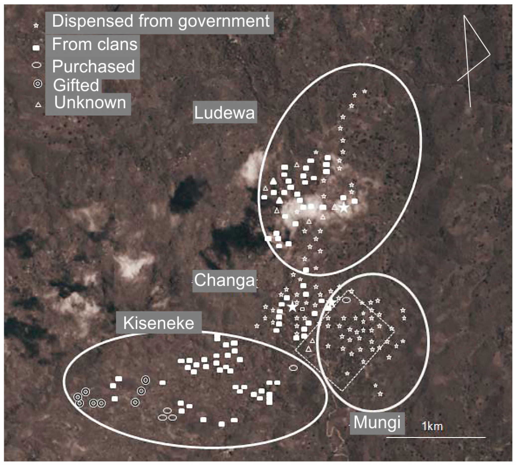
3.9. Effect of Ujaama on the Expansion of Tree Crops in Homegardens

We compared satellite photographs immediately after the Ujaama policy introduction (Figure 4a), and 30 years later (Figure 4b) to see the forest landscape changes in the study area. We found that Mungi and Changa village districts developed a forest landscape within the surveyed Kuboguwa village. Such a forest landscape did not exist in the 1978 photograph when the forced migration began, caused by the Ujamaa policy (Figure 4a and Figure 5). The photograph from 1978 confirmed the growth of tree crops around the homegardens in the settlements of Ludewa, but, with a lower number of trees than those found at present. This suggests that, in this period, most of the forest landscape developed in the village, present in more recent pictures, was very small and did not appear in the aerial view. There were no tree crops, except banana, in the region until around five decades ago when the tree crops were introduced from Zanzibar Island. Therefore, 50 years ago, the landscape of homegardens differed completely from that indicated at present.
Figure 5 shows plots of the households in the four village districts and how they obtained their homegardens. The results reveal households which were forced to migrate, received their homegarden parcel from the village government, and continue to live on that land at present. Even within the same village, forced migration through the Ujamma policy affected some districts. Some of the migrated people stayed in the lower part, and some of them returned to their original lands in the upper part. Although some villagers were forced to relocate to the lower part of the district, they kept their original property in the upper part of the Kiseneke district. Consequently, the Ujamaa policy hardly affected the Kiseneke village district (Figure 5). Conversely, in the other three districts—Ludewa, Mungi, and Changa—many people who lived along the ridge running through the center of the village were forced to migrate to locations with no previous settlement and continued to live in these places. Therefore, these village districts became places with a better-developed forest landscape and the Ujamaa policy played a vital role in this regard.

3.10. Effects of the Ujamaa Policy on the Land Outside the Homegardens

According to the survey results of 80 households in 2007, 37 of 80 households (46.3%) obtained their homegarden land through inheritance, either paternal or maternal. The next most frequent source was distribution from the government (32 households, 40.0%). The Socialist policy was implemented in Tanzania from the 1960s to the first half of the 1970s. As part of that policy, in the construction and promotion of Ujjama village, people living in a dispersed way increased agricultural productivity (Hyden, 1980). From 1971 onwards, a semi-compulsive migration strategy (Operation Vijijini) was initiated nationwide. In Kibogwa village, in 1974, the land of a specific clan (exactly Lineage) was confiscated by the Tanzanian government and the residence was redistributed including households not belonging to the clan. In 2007, 32 households, about 40% of the surveyed 80 households, lived on land granted by or inherited from the government. Most of the clan’s land that was confiscated by the government is residential, and most of the cultivated land preserved the customary land holding, as established from the interviews with the elderly. In addition, it seems that the collection was carried out in units of village districts; the residence seems to have not moved beyond the scope of the village; the original villagers use the cultivated land of the village to settle. This did not change before or after.
Many households divide these fields into parcels and cultivate three parcels per year. Many households cultivated rice in the fields on the slopes of the ridge away from the high concentration of homegardens. According to the survey results of 80 households in 2007, households cultivated 268 land parcels. Among them, 197 parcels (73.5%) were obtained via the clan by the present cultivators. The 44 parcels (16.4%) were cultivated in different ways: 26 parcels were leased for cash, 17 were purchased, and only 1 parcel was a sloping field allocated by the government. Information on how the remaining 27 parcels were obtained was unknown. Accordingly, the Ujamaa policy does not have any practical effect on how sloping fields are used at present. Of the 268 parcels, 65 (24.25%) contained maize; 94 (35.1%), rice; and 78 (29.1%), cassava, together representing 88.45% of the total cropping. Sloping fields used as fallow or for the cultivation of other crops constituted only three parcels (1.12%), but they did not cultivate perennial crops. The region’s matrilineal clan plays a substantial role in the distribution of sloping fields and their methods of use. Consequently, the cultivation of perennial crops such as tree crops and banana remains limited in the sloping areas.
Following the land tenure system in the study area, it is thought to be difficult to plant perennial crops such as banana or tree crops in the fields on the slopes. Therefore, on sloping fields that extend outside the homegardens, hardly any tree crops are planted [20]. The sloping fields have been used for the cultivation of short cycle crops of staple food such as maize, rice, or cassava, under the influence of traditional land tenure systems possessed by Matrilineal clans [20]. From these results, it was determined that on the lands which were distributed by the village government, the influence of the traditional land tenure system was removed and people started to cultivate perennial crops on their own land.
However, some homegardens might cultivate just one of the staple food crops, as in the case of household number 34, which planted rice crops in the entire homegarden. Maize is cultivated at a comparatively high elevation within the village; in many cases, it is cultivated at an elevation of 800 m or above on the large ridge in the Kiseneke village district that divides the village in half. Rice plants and cassava are frequently cultivated at elevations of 800 m and below. In particular, rice plants are often cultivated on the sloping fields to the south of the area where the homegardens are concentrated in the Mungi village district (Figure 5). On such sloping fields, the land-use pattern for the cultivation of staple food crops reveals similarities between the households in this village: fixed location and growing season. In addition to the land tenure system centered on matrilineal clans, there is a cropping system based on the forms of regional meals that also defines the crop varieties planted in the sloping fields. Therefore, the cropping patterns in homegardens differ from the sloping fields.

3.11. Changes of the Tree Crop Cultivation

By comparing the satellite images of December 2013 with those in 2005, we traced the direction of the Kiboguwa Village forest landscape development (Figure 4b,c). We identified more abundant vegetation with newly constructed houses in the 2013 image. However, many of the houses visible in the image of 2005 still exist after eight years, and the forest landscape also covered practically the same range (Figure 4b,c). In 2005 and 2013, the upper region in the image mainly showed the cultivation of rice with hardly any trees occurring in this place. In Kiboguwa Village, some of the homegardens are abandoned due to the death or migration of the head of the household. In Kiseneke, there was a relatively frequent migration tendency, and the places used as homegardens frequently became unmanned and fell into an abandoned state. These aforementioned abandoned states are known as Biamo.
Of the 55 households in Kiseneke surveyed in 2005, five established homegardens at separate locations or moved to a different household to start living at this new location in 2006. Of these five households, in two households, the wife returned to her original home due to divorce. In another household, an elderly lady lived alone and, to live with her son, she established a homegarden in a more central part of the village and moved there. Therefore, the location of a previous homegarden returned to its original characteristics. In the remaining two households, one household had poor relations with the neighbors and moved to another village and, in the other household, a sister with a deteriorated relationship with her brother established a new home in the field of her husband. Therefore, although the locations of the homegardens changed, the land use in the village remained likely the same over the eight years.

3.12. Characteristics of the Household Structures on Cropping Patterns

The households with homegardens distributed at elevations of 900 m and below are arranged according to the ages of their oldest member (Table S1). In the study area, households presented a strong tendency to have a nuclear family. Household numbers 14, 35, and 40 were occupied by widows, their mothers, and children (Table S1).
Except for household numbers 14, 35, and 40, the cropping patterns shift following each change of generation. Married couples established new homegardens in fields inherited from either the parents of the wife or the husband. However, because only annual crops are planted in the inherited fields, the couples plant new crops according to their preference. Therefore, the cropping pattern in homegardens reflected the preferences and necessities of the married couples. We considered this as one of the leading factors to the generation of diversity in the homegarden cropping patterns among households.
When evaluated the homegardens according to the age of the eldest member, who we considered as the head of the household; we observed that the method of obtaining homegardens differed by age group. The heads of eight households were in their seventies or older. Six households obtained their homegarden during the forced migration in 1974, in their 60s. The head of household number 35 was in her 50s or younger, and the heads of household numbers 24 and 28, answered that they migrated to the land allocated to them by the government.
Under the Ujamaa policy, immigrants supposedly received fixed and equally distributed areas of land. However, the head of household number 20 obtained a narrower homegarden in comparison to those of the other households. The head of this household had four wives, of whom three lived at an adjacent homegarden. Furthermore, his sons lived together with these three wives at household numbers 18 and 19 and had established homegardens close to that of their father. All of these lands formerly belonged to the head of household number 20.
In summary, age group explains how homegardens differed in terms of how they were acquired and their size. This suggested that the older age group tended to receive a bigger homegarden. The ratio of the cropping area for tree crops tended to be higher among the older age groups.

4. Discussion

We identified the cropping patterns of the homegardens in Kiboguwa village, located in the mountainous area of central Tanzania, through a survey of participant observations accompanied by a long-term stay. This allowed us to evaluate the critical factors related to the cropping patterns such as geography, climate, history, land use policies, and the cultural behavior on land use, particularly the Ujamaa policy.
The crops cultivated in the homegardens in the research area changed over time. Previous reports suggest that Bananas were introduced in the distant past, and an English explorer from the 19th century described how the Luguru people wore the leaves of banana plants instead of clothes [21]. Coffee also arrived there a long time ago, with records of a German who began cultivating coffee in the 1890s on the western slopes of Mgeta [29]. However, the route by which coffee was introduced into the village studied (Kiboguwa) remains unknown. A remarkable increase in the number of tree crops in this region likely occurred around the time of Tanzania’s independence, 60 years ago. In the same period, spice crops such as cinnamon and clove, which are cultivated as staple food crops, were also introduced into this region. This introduction likely resulted from the poll tax imposed by British colonial rule. Many people wanted to escape the poll tax and, at that time, the country was still divided and conquered by the Arabs and British [30]. Hence, people headed for the Arab Zanzibar Island which was not within the scope of the poll tax. On Zanzibar Island, they became seasonal workers on the clove plantations established by the Arabs, and the Luguru people visited the island together with the Sukuma and Nyamwezi people who lived in the northern part of Tanzania [28]. Before independence, the people who went to Zanzibar Island subsequently returned to the region studied in this research and brought with them many crops, which might explain the sudden increase in the number of trees crops. When coconuts were introduced also remains unclear. Since slaves on Zanzibar Island used coconut plantations [28], the introduction of coconut might have occurred similarly as that of clove; they arrived in this region around the time of independence.
At present, many homegardens have created an expansive forest landscape centered on the Changa, Mungi, and Ludewa village districts that developed on land excluded from the allocation of land to clans during the implementation of the Ujamaa policy. Following the land tenure system in the study area, it is thought to be difficult to plant perennial crops such as banana or tree crops in the fields on the slopes. Therefore, on sloping fields that extend outside the homegardens, hardly any tree crops are planted there [20]. Land distributed by the village government under the Ujamaa policy removes the influence of traditional land tenure, and people started to cultivate perennial crops including banana in their homegardens. About 60 years ago, at the time of the immigration under the Ujamaa policy, the cropping pattern of the homegardens, less than 900m above sea level, suitable for many tree crops, became diverse.
In addition, ecological differences which are observed at different altitudes of the slopes increase the diversity of the cropping patterns of the homegardens in the village. Commercial crops such as cinnamon, clove, coffee, and coconut were the most cultivated, many of which require a damp environment with a high temperature for growth. The suitable conditions for growing cinnamon are an average temperature of between 20 °C and 30 °C; annual rainfall of 1250–2500 mm, and an elevation of 300–350 m. The suitable conditions for growing clove are a temperature between 24 °C and 33 °C with annual rainfall of 2000–3000 mm, and an elevation range of 300–600 m [31]. Moreover, the suitable conditions for growing coconut are an average temperature of 27 °C to 28 °C, but not below 20 °C, similar to cinnamon. The monthly rainfall should be an average of 130 mm (around 50 mm in the dry season); therefore, in Eastern Africa, these crops can be grown at elevations of 1100 m and below (Weis, E.A. 2002). Many of the tree crops cultivated in this village were suitable for cultivation at low altitude in the village. The cultivation of herbaceous crops was also observed at altitudes suitable for their cultivation characteristics.
Furthermore, the family structure and custom homegarden land use of the village also contributed to the diversity of the homegarden cropping patterns. Households in this village are often composed of nuclear families, with one homegarden per household. Typically, after abandonment, a homegarden becomes indistinguishable from a normal field. However, the cropping patterns of an abandoned homegarden for only one generation still reflected the ideas of the people living there, their ages, and household structure. This likely increased the diversity of homegarden cropping patterns within the study area. In some regions of the islands of Southeast Asia, people manage crops in their homegardens over many generations. In these regions, homegardens become places where culture flows from one generation to another [32]. The cropping patterns noted in the Southeast Asia homegardens, which mainly grow banana and coffee, differed from those indicated in our study: their cropping patterns are less likely to reflect factors such as the ages, preferences, and health conditions of the family members. Additionally, the tendency to pass down homegarden cropping patterns through generations can be noted in the Kilimanjaro and Usambara Mountains [33].

5. Conclusions

The diversity of the cropping patterns observed in the homegardens in this study village was influenced by factors related to regional characteristics such as the regional history and the customs and policies. The introduction of tree crops began with people returning from Zanzibar island, before and after the colonial era, who brought back various crops to this area. Furthermore, the customs concerning the ownership of lands possessed by maternity clans and the ownership of trees has been partly broken by the Ujama policy and tree crop cultivations started to spread in homegardens in the village. In addition, households are often composed of nuclear families, and the land of homegardens tends to be abandoned by one generation. Such factors contribute to the diversity of cropping patterns. In addition, ecological diversity distributed on the slopes of the Mountains from around 650 m to around 1200 m, also makes the cropping pattern diverse. In homegardens distributed above 900 m, only a few tree crops were observed. Instead of tree crops, herbaceous crops such as maize or common bean or banana were cultivated. Because bananas are not a main staple food crop for the people of Kiboguwa village, there are some homegardens in which only few bananas were cultivated. This point is not the same as the homegardens of people in the northern part of Tanzania who are called banana eaters. Therefore, it can be said that cultural differences in terms of staple food crop affected the diversity of cropping patterns in both areas. The contents or methods of agricultural and rural development projects or the purpose of research on tropical agriculture must be relevant to actual situations [34]. In agricultural technological supports, the agriculture of the target area of the projects is analyzed mainly from economical or agro-ecological point of view [35]. Factors influencing cropping patterns are assumed to be different in the region, and the contents of agricultural technical supports targeting the hormegardens must be different among these regions. Without knowing suitable and specific points of view for each area, the nature or real background of the phenomenon could not be understood. Analysis using an inductive method—considering the background against which the phenomenon becomes evident after collecting the information from the target area in this manner—is thought to lead to an essential understanding. By investigating the cropping patterns of homegardens, we provided information to support future developments that improve the agricultural development in such rich Tanzanian homegardens. In this study, we tried to understand the relationship between the phenomenon appearing as cropping patterns from the viewpoint of the investigator and the factors acting on it. However, information on how farmers’ own thinking and intention about cropping of the homegardens have not been collected. Such research is also considered to be necessary.

Supplementary Materials

The following are available online at https://www.mdpi.com/2077-0472/8/9/141/s1, Table S1: Information on household members who have lived together at a homegarden and characteristics of cropping patterns of each homegarden.

Author Contributions

J.K. and Y.Y. conceived and designed the experiments; K.I. performed the experiments; and Y.Y. analyzed the data; Y.Y. contributed reagents/materials/analysis tools; Y.Y. wrote the paper.

Funding

This study was funded by the Ministry of Education, Culture, Sports, Science and Technology Grant-in-aid for Scientific Research (grant number: 16101009; Representative: Kakeya Makoto) “Comprehensive research on African-type rural development based on regional research”. The findings reported in this study are part of this research.

Conflicts of Interest

The authors declare no conflict of interest.

References

  1. Nair, P.K.R.; Kumar, B.M. Introduction. In Tropical Homegardens: A Time-Tested Example of Sustainable Agroforestry; Kumar, B.M., Nair, P.K.R., Eds.; Springer: Dordrecht, The Netherlands, 2006; pp. 1–12. [Google Scholar]
  2. Peyre, A.; Guidal, A.; Wiersum, K.F.; Bongers, F. Dynamics of homegarden structure and functions in Kerala, India. Agrofor. Syst. 2006, 66, 101–115. [Google Scholar] [CrossRef]
  3. Wiersum, K.F. Diversity and change in homegarden cultivation in Indonesia. In Tropical Homegardens: A Time-Tested Example of Sustainable Agroforestry; Kumar, B.M., Nair, P.K.R., Eds.; Springer Science: Dordrecht, The Netherlands, 2006; Volume 3. [Google Scholar]
  4. Galhena, D.H.; Freed, R.; Maredia, K.M. Home gardens: A promising approach to enhance household food security and wellbeing. Agric. Food Secur. 2013, 2, 8. [Google Scholar] [CrossRef]
  5. Abebe, T.; Wiersum, K.F.; Bongers, F. Spatial and temporal variation in crop diversity in agroforestry homegardens of southern Ethiopia. Agrofor. Syst. 2010, 78, 309–322. [Google Scholar] [CrossRef]
  6. Soda, O. The History of Modern Agricultural Thought—For Agriculture in the 21st Century; Iwanami Shyoten: Tokyo, Japan, 2013; p. 236. (In Japanese) [Google Scholar]
  7. Suzuki, S. Agricultural Extension in Developing Countries and Its Evaluation; Tokyo Agricultural University Publishing Association: Tokyo, Japan, 2010; pp. 230–247. (In Japanese) [Google Scholar]
  8. Tsuruta, T. Historical consideration of agriculture/pastoral complexes in Western African semi arid areas; case examples of the Tanzania ground strip and its surroundings. Bull. Fac. Agric. Kinki Univ. 2011, 44, 97–114. (In Japanese) [Google Scholar]
  9. Zimpita, T.; Biggs, C.; Faber, M. Gardening Practices in a Rural Village in South Africa 10 Years after Completion of a Home Garden Project. Food Nutr. Bull. 2015, 36, 33–42. [Google Scholar] [CrossRef] [PubMed] [Green Version]
  10. Assefa, T.T.; Jha, M.K.; Reyes, M.R.; Schimmel, K.; Tilahun, S.A. Commercial Home Gardens under Conservation Agriculture and Drip Irrigation for Small Holder Farming in sub-Saharan Africa. In Proceedings of the ASABE Annual International Meeting, Spokane, WA, USA, 16–19 July 2017. [Google Scholar]
  11. Kim, D.G.; Terefe, B.; Girma, S.; Kedir, H.; Morkie, N.; Woldie, T.M. Conversion of home garden agroforestry to crop fields reduced soil carbon and nitrogen stocks in Southern Ethiopia. Agrofor. Syst. 2017, 90, 251–264. [Google Scholar] [CrossRef]
  12. Gbedomon, R.C.; Salako, V.K.; Fandohan, A.B.; Idohou, A.F.R.; Kakaї, R.G.; Assogbadjo, A.E. Functional diversity of home gardens and their agrobiodiversity conservation benefits in Benin, West Africa. J. Ethnobiol. Ethnomed. 2017, 13, 66. [Google Scholar] [CrossRef] [PubMed]
  13. Amberber, M.; Argaw, M.; Asfaw, Z. The role of homegardens for in situ conservation of plant biodiversity in Holeta Town, Oromia National Regional State, Ethiopia. Int. J. Biodivers. Conserv. 2014, 6, 8–16. [Google Scholar]
  14. Abebe, T. Diversity in Homegarden Agroforestry Systems of Southern Ethiopia. Ph.D. Thesis, Wageningen University, Wageningen, The Netherlands, 2005. [Google Scholar]
  15. Maruo, S. People who live with bananas: A case study of the village of the Haya in Western Tanzania. In African Farmer’s World—Transformation and Its Indigenous; Kakeya, M., Ed.; Kyoto University Press: Kyoto, Japan, 2002; pp. 51–90. (In Japanese) [Google Scholar]
  16. Reyes, T.; Quiroz, R.; Msikula, S. Socio-economic comparison between traditional and improved cultivation methods in Agroforestry systems, East Usambara Mountains, Tanzania. Environ. Manag. 2005, 36, 682–690. [Google Scholar] [CrossRef] [PubMed]
  17. Rugalema, G.H.; Okting’Ati, A.; Johnsen, F.H. The homegarden agroforestry system of Bukoba district, North-Western Tanzania. 1. Farming system analysis. Agrofor. Syst. 1994, 26, 53–64. [Google Scholar] [CrossRef]
  18. Soini, E. Land use change patterns and livelihood dynamics on the slopes of Mt. Kilimanjaro, Tanzania. Agrofor. Syst. 2005, 85, 306–323. [Google Scholar] [CrossRef]
  19. Masawe, J.L. Farming system and agricultural production among small farmers in the Uluguru Mountain area, Morogoro region, Tanzania. Afr. Study Monogr. 1992, 13, 171–183. [Google Scholar]
  20. Yamane, Y.; Kularatne, J.; Ito, K. Agricultural production and food consumption of mountain farmers in Tanzania: A case study of Kiboguwa village in Uruguru Mountains. Agric. Food Secur. 2018, 7, 54. [Google Scholar] [CrossRef]
  21. Young, R.; Fosbrooke, H. Land and Politics among the Luguru of Tanganyika; Routledge & Kegan Paul: London, UK, 1960. [Google Scholar]
  22. Beidelman, T.O. The Matrilineal Peoples of Eastern Tanzania; International African Institute: London, UK, 1967. [Google Scholar]
  23. Yamane, Y.; Higuchi, H. Subsistence strategy of small farmers observed in planting of commercial crops in the homestead of the mountains of rural Tanzania: A case study of Kiboguwa Village on the Eastern Slopes of Uluguru Mountain in Tanzania. J. Agric. Dev. Stud. 2016, 27, 1–12. (In Japanese) [Google Scholar]
  24. Maxwell, J. Qualitative Research Design: An Interactive Approach; Applied Social Research Methods; SAGE Publications: London, UK, 2005; pp. 87–121. [Google Scholar]
  25. Krebs, C.J. Ecological Methodology, 2nd ed.; Group Limited Wesley, Longman: Harlow, UK, 1998. [Google Scholar]
  26. Rwezimula, F.; Tanaka, U.; Ikeno, J. Agro-ecological characteristics and inherent roles of indigenous farming systems on the eastern slopes of northern Uluguru Mountains, Tanzania. J. Agric. Dev. Stud. 2010, 20, 65–71. [Google Scholar]
  27. Arcland, J.D. East African Crops; Longman Group Limited: Hong Kong, China, 1980. [Google Scholar]
  28. Odhiambo, E.S.A.; Ouso, T.I.; Williams, J.F.M. The Inter Years: Tanganika, Zanzibar and Rwanda-Urundi Pages: A History of East Africa; Longman Group Limited: Guangdong, China, 2006. [Google Scholar]
  29. Ponte, S. Trapped in decline? Reassessing agrarian change and economic diversification on the Uluguru Mountains, Tanzania. J. Mod. Afr. Stud. 2001, 39, 81–100. [Google Scholar] [CrossRef]
  30. Pretty, J. Agri-Culture-Reconnecting, People, Lands and Nature; Earthscan: London, UK, 2002. [Google Scholar]
  31. Ravindran, P.N.; Nirmal-Babu, K.; Shylaja, M. Cinnamon and Cassia ‘The Genus Cinnamomum’. In Medicinal and Aromatic Plants Industrial Profiles; CRC Press: Boca Raton, FL, USA, 2004. [Google Scholar]
  32. Galluzzi, G.; Eyzaguirre, P.; Negri, V. Home gardens: Neglected hotspots of agro-biodiversity and cultural diversity. Biodivers. Conserv. 2010, 19, 3635–3654. [Google Scholar] [CrossRef]
  33. Rao, M.R.; Rao, B.R.R. Medical plants in tropical homegardens. In Tropical Homegardens: A Time-Tested Example of Sustainable Agroforestry; Kumar, B.M., Nair, P.K.R., Eds.; Springer: Dordrecht, The Netherlands, 2006; pp. 205–232. [Google Scholar]
  34. Angelsen, A.; Kaimowitz, D. Rethinking the causes of deforestation: Lessons from economic models. World Bank Res Obs. 1999, 14, 73–98. [Google Scholar] [CrossRef] [PubMed]
  35. Nishimura, Y. Agriculture Rural development and technology development Technology transfer. In Introduction to International Development Studies: Interdisciplinary Construction of Development Studies; Otubo, S., Kimura, H., Ito, S., Eds.; Kusakasybo Limited: Saitama, Japan, 2009; pp. 334–343. [Google Scholar]
Figure 1. Location of Kiboguwa village in the Uluguru Mountains (a); and distribution of the 43 surveyed households in Kiboguwa village (b).
Agriculture 08 00141 g001
Figure 2. Schematic diagrams of the cropping patterns among neighboring homegardens (Ludewa).
Agriculture 08 00141 g002
Figure 3. Relationship between altitude of homegardens and cultivated number or area occupied by each crop in each homegarden. (a) Tall tree crops. (b) Short tree crops. (c) Herbaceous crops (number). (d) Herbaceous crops (area).
Agriculture 08 00141 g003
Figure 4. Effects of the Ujamaa policy on the development of forest-like landscape in the study village. Comparison of aerial photographs obtained in 1978 (National Information purchased from Office for Dar es Salaam) and satellite images obtained in 2005 and 2013 (purchased from Pasco Corporation; Quick bird pan-sharpened image). The dotted boxed portion indicates the satellite images and the aerial extent of the image shown in Figure 4.
Agriculture 08 00141 g004
Figure 5. Distributions of 258 households in the four village districts shown using different symbols according to the methods of how the lands were obtained. The symbol (☆) indicates the households which were forced to migrate, received their homegarden plot from the village government, and continue to live on that land. Quick bird image (2005).
Agriculture 08 00141 g005
Table 1. Information on the four types of cropping patterns.
Household No.Cropping PatternVillage DistrictAltitudeAreaPercentage of cropping AreaIndex of DIVERSITy *Number of Crop Species (3a) The Percentage of Area Occupied by Tree CropsTall Herbaceous CropMedium Herbaceous Crops(3b) The Percentage of Area Occupied by Herbaceous Crops
TotalTree CropsHerbaceous CropsTall TreeShort TreeTotalShort Herbaceous CropsTotal
(m)(Acre)(%) (Spieces)(Spieces)(Spieces)(%)(%)(%)(%)(%)(%)(%)
35Type ILudewa6580.3753.20.59136689.43.793.15.40.51.0 6.9
39Type ILudewa6581.0029.50.77139471.216.888.04.54.03.5 12.0
27Type IMungi7341.4579.50.941310364.022.686.69.34.10.0 13.4
26Type IMungi7361.3854.30.781310380.43.984.311.61.6 2.5 15.7
22Type IChanga8100.5873.70.80169766.714.881.513.25.3 0.0 18.5
43Type ILudewa6400.2439.90.7386273.38.181.418.60.0 0.0 18.6
28Type IMungi7000.8585.10.76137656.123.579.68.92.8 8.7 20.4
38Type ILudewa6300.3244.60.73117468.35.874.05.720.2 0.0 26.0
37Type ILudewa6640.9951.80.671210259.59.969.430.60.0 0.0 30.6
31Type IMungi6600.8070.30.911911866.13.069.123.05.3 2.5 30.9
29Type IMungi7710.9678.50.6894515.049.964.81.620.3 13.2 35.2
23Type IChanga7910.8058.00.69115660.11.161.225.09.5 4.4 38.8
Averadge7040.8159.90.7512.67.84.768.610.377.814.24.8 2.1 22.2
42Type IILudewa6350.4978.40.6485319.436.455.87.80.0 36.4 44.2
41Type IILudewa6490.3926.00.5885347.85.453.344.72.1 0.0 46.7
14Type IIKiseneke8530.5874.70.90149535.716.352.026.40.4 21.2 48.0
17Type IIKiseneke8501.1291.00.94159618.832.851.620.026.4 2.0 48.4
30Type IIMungi7000.5961.70.871310330.720.651.317.830.9 0.0 48.7
21Type IIChanga8301.8447.40.84116537.913.351.210.64.4 33.8 48.8
33Type IIMungi6601.1392.90.94179842.96.949.924.922.9 2.4 50.1
32Type IIMungi7040.7983.30.90167931.216.848.09.14.1 38.8 52.0
20Type IIKiseneke7250.3877.10.82136740.67.147.65.710.3 36.4 52.4
19Type IIKiseneke7350.1852.10.7095443.43.146.56.73.9 42.9 53.5
16Type IIKiseneke8270.5990.40.852391433.86.940.821.613.3 24.3 59.2
Averadge7430.7464.70.8213.47.36.134.815.064.917.710.8 21.7 35.1
36Type IIILudewa7350.5362.80.791810827.87.735.516.0 45.2 3.4 64.5
24Type IIIMungi7820.5267.90.69118316.316.132.40.0 2.5 65.1 67.6
10Type IIIKiseneke8600.3248.00.66138514.513.528.012.857.51.7 72.0
13Type IIIKiseneke8300.9589.90.9824111319.38.527.835.514.222.5 72.2
34Type IIILudewa7010.7989.80.7994524.01.725.835.417.121.7 74.2
40Type IIILudewa6490.7048.10.5895424.20.824.915.559.60.0 75.1
15Type IIIKiseneke8380.5383.60.851651118.53.221.78.168.41.8 78.3
11Type IIIKiseneke8600.3461.80.7212573.013.916.914.033.235.9 83.1
Averadge7820.5869.00.7614.07.07.018.87.026.619.642.212.4 73.4
8Type IVKiseneke9020.4375.60.84166105.98.714.616.435.133.9 85.4
2Type IVKiseneke11750.5488.10.5410469.30.910.343.83.742.3 89.7
9Type IVKiseneke9100.3893.20.6814687.41.79.114.637.039.3 90.9
1Type IVKiseneke12220.7080.30.737254.42.36.721.341.730.2 93.3
12Type IVKiseneke8521.2337.70.6513674.61.76.333.229.930.6 93.7
7Type IVKiseneke9200.5388.80.5810282.63.76.315.038.740.1 93.7
4Type IVKiseneke11090.4469.30.78141130.00.30.332.931.735.199.7
Averadge10130.676.10.6912.03.98.14.62.27.724.732.136.492.3
25Type VMungi8000.4484.60.4612664.261.966.10.931.91.133.9
5Type VKiseneke9500.2165.60.486247.30.57.820.863.38.192.2
6Type VKiseneke9440.1576.40.4810554.33.47.75.185.41.892.3
3Type VKiseneke11700.7471.70.406050.00.00.024.47.967.7100.0
18Type VKiseneke7360.1782.90.293030.00.00.07.513.978.6100.0
Average9050.5476.20.4211.54.66.87.926.316.33.030.832.083.7
* Shows the value of the exponent (D = (Σsin/N)2) of Simpson.
Table 2. Classification of the 23 tree crops observed in the homegardens of the 43 households according to their height.
Tree Form-Plant TypeSpecies NumberEnglishLocal NameSpeciesAverage HeightMaxNumber MeasuredPercentage MeasuredTotal Observed
(m)(m)(Number)(%)(Number)
Tall trees1Coco palmMinaziCocos nucifera L.14.1 25.0 9032.7 275
More than 15 m2Bread FruitMsherisheliTreculia africana Decne.13.6 19.0 6459.3 108
3Jack FruitFenesiArtocarpus heterophyllus Lam.11.8 20.0 7566.4 113
4-Mwembe ng’ong’oSclerocarya birrea (A. Rich.) Hochst.14.6 19.4 1688.9 18
5EucalyptusMaidiniEucalyptus sp.15.3 23.0 1688.9 18
6East African mahoganyMkanbaziKhaya anthotheca (Welw.) C.DC.13.2 25.0 2244.9 49
7KapokMsufiCeiba pentandra (L.) Gaertn.13.5 22.0 480.0 5
8DurianMdurianiDurio zibethinus L.20.0 20.0 1100.0 1
9JambolanMzambaraweSyzygium cuminii L.16.0 16.0 125.0 4
Short trees11African Oil PalmChikichiElaeis guineensis Jacq.8.0 8.0 150.0 2
Less than 10 m12AvocadoMfukadoPersea americana Mill.8.1 8.0 1536.6 41
13MangoMihembeMangifera indica L.5.0 23.0 2100.0 2
14CloveAmdarasiniSyzygium aromaticum (L.) Merrill & Perry5.6 12.0 4932.0 153
15CinnamonAmdarasiniCinnamomum zeylanicum J.Presl3.4 8.0 454.5 997
16CoffeeBuniCoffea arabica/robusta L.3.1 8.0 2312.0 192
17Tree cassavaChisamvuManihot sp.1.8 2.0 325.0 12
18BambooMlanziBambusoideae spp.3.0 3.0 7-
19OrangeMchenzaCitrus reticulata Blanco, 18372.9 8.0 1470.0 20
20PapayaPapaiCarica papaya L.2.0 2.0 637.5 16
21SoursopStafeliAnnona muricata L.4.0 5.0 375.0 4
22-Mkaranga mti Bombax rhodognaphalon A.Robyns2.3 3.0 250.0 4
23-KitupaTephrosia vogelii Hook.f.1.7 2.0 330.0 10
Table 3. Classification of the 24 herbaceous crops observed in the homegardens of the 43 households according to their height.
Tree Form-Plant TypeNumber of SpeciesEnglishLocal NameSpecies
Tall herbaceous crops More than 5 m1BananaMakowoMusa spp.
2Black pepperPilipili mtamaPiper nigrum L.
3Oyster nutsMkwemeTelfairia occidentalis Hook.f.
Medium herbaceous crops1–5 m4CardamomIlikiElettaria cardamomun (L.) Maton
5Coco yamGhimbiColocasia esculenta (L.) Schott/Xanthosoma sagittifolium
6CassavaGumuhogoManihot esculenta Crantz
7Castor oil plantMnyembaRicinus communis L
8Hyacinth beanFyifyiLablab niger (L.) Sweet
9Night shadeDideregaBasella alba L.
10MaizeDitamaZea mays L.
11OkraDibamiaAbelmoschus esculentus (L.) Moench
12Passion fruitsMatunda kwemePassiflora edulis Sims, 1818
13Pigeon peaZimangeCajanus cajan L.
14SisalMkongeAgave sisalana Perrine
15Scarlet runnerKikambaPhaseolus coccineus L.
16SugarcaneMguwaSaccharum officinarum L.
17YamVigonzoDioscorea alata L.
Short herbaceous cropsLess than 1 m18AmaranthsGumchichaAmaranthus spp.
19BasilNot sureOcimum basilicum L.
20Bitter tomatoZinungwiSolanum spp.
21ChiliPilipiliCapsicum frutescens L.
Capsicum chinense Jacq.
Capsicum annuum L.
22GingerMbwigaZingiber officinale Roscoe
23Kidney beansMaharagiPhaseolus vulgaris L.
24PineappleDinanasiAnanas comosus (L.) Merr.
25RiceUhungaOryza sativa L.
26RoselleDamudamuHibiscus subdariffa L.
27Sweet potatoTenbereIpomoea batatas (L.) Lam.
28TomatoNyanyaLycopersicon esculentum L.
29VanillaNot sureVanilla planifolia Jacks. ex Andrews

