1. Introduction
Soil moisture is a fundamental variable in hydrological and erosive processes, influencing water infiltration, runoff generation, and soil loss [
1,
2]. In semiarid regions, where precipitation is scarce and highly variable, the accurate monitoring of soil water content (SWC) is essential for effective land and water management [
3]. Conventional approaches for measuring SWC, such as gravimetric sampling and dielectric sensors, offer reliable point-scale information, but often fail to capture the spatial variability required to inform field and catchment scale processes. Due to their limited footprint, extensive and time-consuming sampling is needed to characterize this variability [
1,
3]. However, these approaches are highly valuable for precise localized measurements and for validating other techniques. Remote sensing, on the other hand, provides wider spatial coverage but typically captures surface moisture at low spatial or temporal resolution [
4]. These limitations result in a critical gap in reliable soil moisture monitoring at intermediate scales (defined as spatial dimensions ranging from tens to a few hundred metres), particularly relevant for applications in agriculture, hydrological modelling, and climate validation [
5].
In recent years, nuclear techniques such as cosmic ray neutron sensors (CRNS) and proximal gamma ray spectroscopy (PGRS) have emerged as promising solutions to overcome these challenges. CRNS provides non-invasive, continuous estimation of SWC by measuring ambient epithermal neutron fluxes above the soil surface, which are inversely related to the hydrogen content in the soil, primarily from the water [
6,
7,
8]. This method integrates SWC information over a circular area of 100–150 metres’ radius, with an effective depth penetration between 10 and 80 cm, depending on installation height and soil moisture conditions [
9]. Unlike conventional point-based methods, CRNS captures integrated soil moisture dynamics over larger areas, significantly reducing sampling effort and providing more representative data for hydrological models [
10,
11]. On the other hand, PGRS quantifies natural gamma radiation from radioactive isotopes within the soil, particularly potassium-40 (
40K), which decreases with increased soil moisture due to the attenuation of gamma rays [
12,
13].
The key advantage of PGRS compared to traditional point measurements (field sensors) is its ability to non-invasively provide spatial SWC information with intermediate footprints, typically ranging from decimetres to metres, depending on detector geometry and survey design [
12,
14]. The sensing footprint of PGRS is highly dependent on the size of the detector, as well as the installation height, and significantly smaller than the one provided by CRNS. The effective depth is generally limited to the top 30 cm of soil due to gamma ray attenuation by the soil. These proximal sensors (CRNS and PGRS) enable rapid spatial surveys, allowing effective identification of variations in SWC that would otherwise require extensive point-based sampling with conventional methods [
5,
13,
14].
The potential of these nuclear techniques [
15] for monitoring SWC variations and capturing temporal and spatial dynamics with notable precision is well-established, both for CRNS [
10,
16] and PGRS [
14]. However, in Spain, the implementation of CRNS [
11,
17,
18] and specially PGRS has been limited. Although the individual use of both techniques has been validated in diverse agroforestry systems, their combined use remains largely unexplored today.
The main objective of this study is to evaluate the response of cosmic ray neutron sensors (CRNS) and proximal gamma ray spectroscopy (PGRS) to soil moisture variations induced by a 16 mm rainfall event in an agricultural field. Additionally, the study aims to compare stationary and mobile gamma ray spectroscopy measurements to assess their effectiveness in detecting changes in soil water content (SWC). In this study, we combine together CRNS and PGRS, an integrated approach that remains unexplored, despite its significant potential. By using the complementary strengths of both techniques across differing spatial scales, our study aims to enhance soil moisture-monitoring capabilities and validate the use of nuclear methods for intermediate-scale SWC assessments. This synergy may be particularly valuable in precision agriculture and soil conservation, where both wide coverage and the spatial detail of SWC are needed for informed decision-making.
2. Materials and Methods
2.1. Study Area
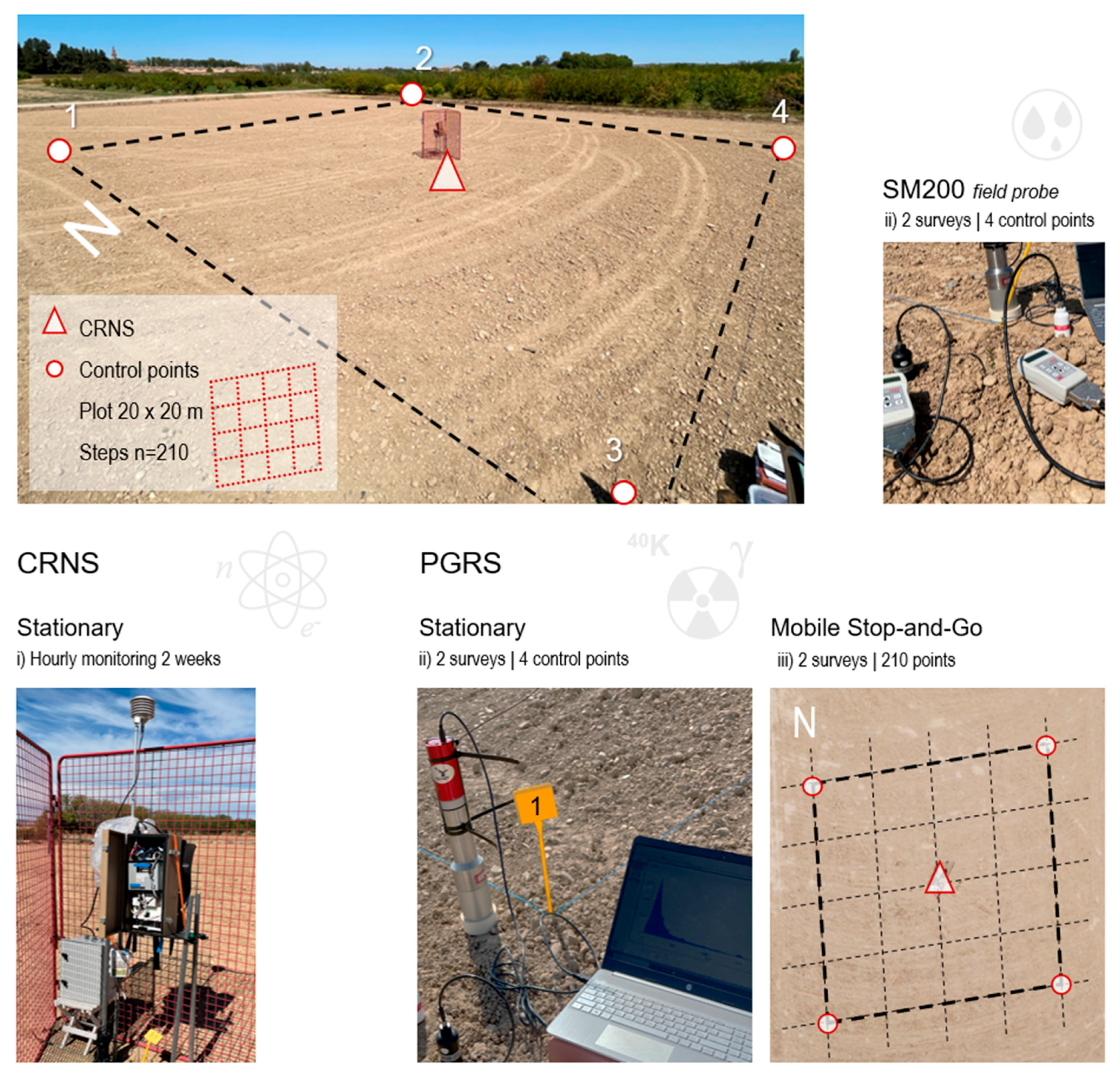
The experiment was conducted at the Estación Experimental de Aula Dei (EEAD-CSIC) in Zaragoza, Spain (41°43′37′′ N, 0°48′46′′ W). The study site is a flat, agricultural field, uncultivated during the study period, with a completely bare soil surface (
Figure 1). This absence of vegetation eliminated the need for biomass correction in the nuclear measurements. The soil is classified primarily as Fluvisol, with a loam texture, moderate carbonate content, alkaline pH, and a high proportion of stone content. The field conditions were representative of semiarid environments, with recorded air temperatures ranging from 12.9 to 36.7 °C during the study period. The absence of significant atmospheric variability reduced the potential for external interference in nuclear sensor measurements.
2.2. Experimental Setup
The experimental setup integrated two nuclear techniques for the field testing of the cosmic ray neutron sensor (CRNS) and the proximal gamma ray sensor (PGRS) to estimate soil water content (SWC). The study was designed to evaluate the response and sensitivity of both sensors to moisture changes induced by a typical summer rainfall event, which occur occasionally during the driest season of the year.
A cosmic ray neutron sensor (CRNS) was installed 2 m above ground level at the centre of the experimental field. This sensor continuously recorded neutron counts at hourly intervals over a two-week summer period, providing uninterrupted monitoring of temporal SWC variations before and after a 16 mm rainfall event that occurred on 1 September (
Figure 1).
The proximal gamma ray spectroscopy (PGRS) measurements were conducted on two different days, under two contrasting soil moisture conditions, before (dry conditions, 28 August) and after (wet conditions, 2 September) the rainfall event. The PGRS campaigns consisted of two approaches, including (i) stationary measurements at fixed points and (ii) mobile stop-and-go across a plot (
Figure 1).
Stationary PGRS surveys were conducted at four fixed control points located at the corners of a 20 × 20 m square plot centred on the CRNS sensor. At each point, gamma ray spectra were acquired over an hour, and spectra were saved every 15 min. This resulted in four spectra per point and per survey, corresponding to a cumulative acquisition time of 15, 30, 45, and 60 min, a total of 32 spectra for the dataset. The gamma detector was positioned 3 cm above the soil surface and measurements were recorded using Genie-2000 software.
Mobile PGRS stop-and-go surveys were also conducted on both days (dry and wet conditions). The survey consisted of five north–south and five east–west transects inside the 20 × 20 m plot, producing a grid of 210 measurement points spaced 1 metre apart. At each stop, the gamma sensor was held at approximately 50 cm above the soil and 40K count data were recorded over 10 s. This approach allowed detailed spatial interpolation of the gamma dataset using kriging techniques.
In addition to the CRNS and PGRS measurements, volumetric soil water content data for the top 5 cm of the soil were recorded at the control points during both the dry and wet surveys using the SM200 field sensor (Delta-T Devices, Cambridge, UK).
2.3. Sensor Data Processing and Analysis
Cosmic ray neutron sensor (CRNS) measurements were performed using a Hydroinnova backpack CRNS sensor (Hydroinnova LLC, Albuquerque, NM, USA). The neutron counts were converted into SWC values using established calibration methodologies and the modified equation proposed by [
19]. Neutrons were corrected for variations in air pressure, high-energy intensity, atmospheric water vapor, and scaled by geomagnetic latitude. The calibration function is as follows:
where
θp is gravimetric water content (g/g),
θLW is lattice water content (g/g),
θSOCeq is soil organic carbon water content equivalent (g/g),
N is the corrected neutron counts per hour (cph), and
N0 is an instrument-specific calibrated parameter that represents the count rate over dry silica soils (cph). The three constants were determined by [
19] from a semi-analytical solution of a neutron diffusion equation, while the CRNS sensor used in this study was calibrated at two sites in Austria, following the procedures and with ten gravimetric surveys [
20].
Proximal gamma ray sensor (PGRS) measurements were performed using a 0.3 L sodium iodide (NaI) scintillator detector (Scionix Holland B.V., Bunnik, The Netherlands) coupled to a high-voltage power supply (HVPS) and a fully integrated multichannel analyser (Osprey
® digital MCA; Mirion Technologies “Canberra”, San Diego, CA, USA) tube base that contains everything needed to support scintillation spectrometry (Mirion Technologies “Canberra”, San Diego, CA, USA). The gamma ray signal emitted by
40K at the energy peak of 1460 keV in the soil–air interface is inversely proportional to soil water content (SWC). As the water content increases, the higher electron density and atomic composition of water cause greater attenuation of gamma rays, reducing the detected signal. This means that with higher SWC, the intensity of the 1460 keV gamma signal decreases, allowing for the estimation of soil moisture levels based on gamma ray attenuation, following the relationship proposed by [
21],
where
SMt is the volumetric soil water content (cm
3/cm
3),
St 40K gamma signal at time t (counts per second, cps), Ʌ
t time-dependent biomass water-content correction factor (dimensionless),
p soil bulk density (g cm
−3),
SCal 40K gamma signal at calibration time (cps) an
wCal gravimetric soil water content (g/g).
2.4. Meteorological Data
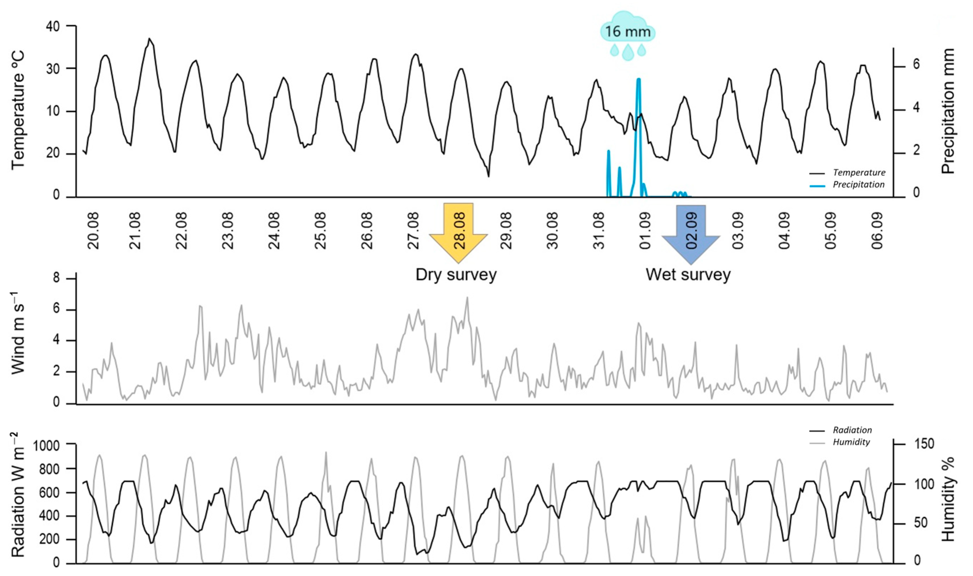
Meteorological data, including rainfall, air temperature, relative humidity, wind speed, and solar radiation, were continually recorded at hourly intervals throughout the study period by a weather station operated by the Spanish meteorological service (AEMET) located contiguous to the experimental field (
Figure 2).
Prior to the rainfall event, the site experienced consistently dry conditions characterised by the absence of precipitation and elevated temperatures. Air temperatures, recorded hourly, ranged from a minimum of 12.9 to a maximum of 36.7 °C, with an average of 23.7 °C. Relative humidity varied markedly, with hourly values fluctuating between 10% and 99%, and averaging approximately 69.6%. Wind speeds were moderate, averaging 2.1 m s−1, with a maximum hourly value recorded at 6.6 m s−1. Solar radiation measurements revealed daily fluctuations, with values reaching up to 901 W m−2, and an average radiation of 247 W m−2 during the entire monitoring period. The rainfall event recorded on September 1 provided a total rainfall input of 16 mm distributed in 24 h. This event significantly altered the previously stable dry conditions and marked a clear transition between dry and wet phases in the monitoring data.
3. Results
3.1. Cosmic Ray Neutron Sensor
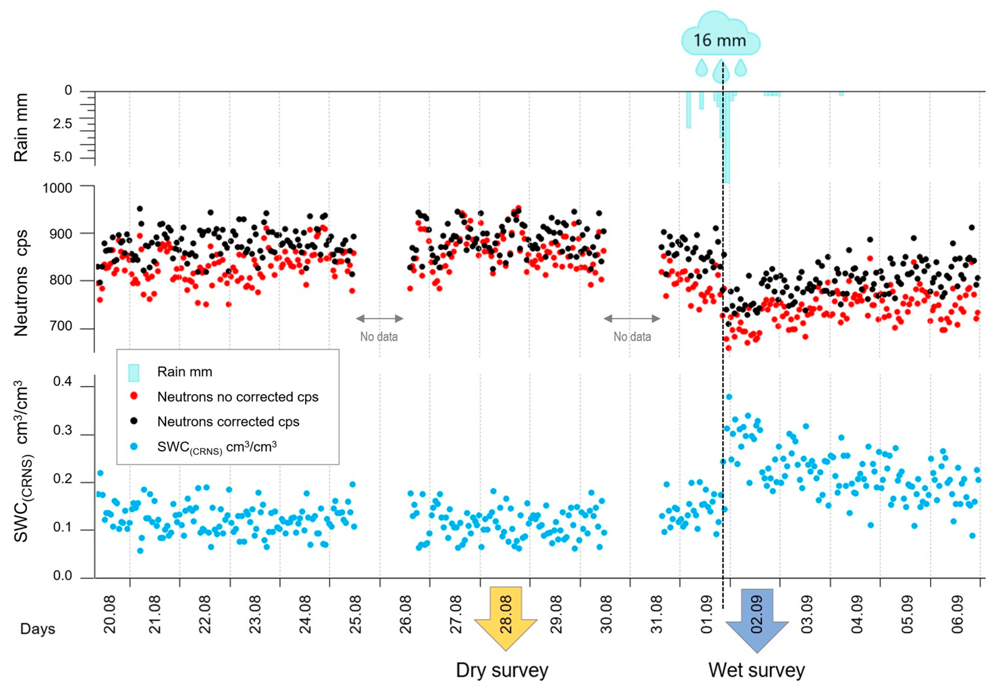
A continuous record of neutron counts, and inferred soil water content (SWC) values was obtained from hourly CRNS measurements throughout the study period (
Figure 3). Uncorrected neutron counts (shown in red) ranged between 651 and 944 counts per second (cps), showing minor fluctuations. Corrected neutron counts (black), adjusted for atmospheric pressure and environmental parameters, followed a similar temporal pattern but exhibited slightly reduced variability due to the applied correction procedures. A clear and abrupt decrease in neutron counts was observed immediately after the 16 mm rainfall event recorded on September 1, followed by a progressive recovery towards initial conditions in the subsequent days.
The values of soil water content (SWC) (blue) obtained from the corrected neutron counts ranged between approximately 0.04 and 0.22 cm3/cm3 before rainfall. The rainfall event triggered a significant increase in SWC, reaching peak values above 0.38 cm3/cm3, followed by a gradual decreasing trend by the end of the monitoring period.
Figure 4 shows the response of CRNS during the dry (28 August) and wet surveys (2 September), respectively. Neutron count rates decreased significantly under wet conditions, with mean values dropping from 826 (±34) to 777 (±30) cps. The mean of SWC
CRNS estimated increased accordingly, from 0.18 (±0.02) to 0.31 (±0.03) cm
3/cm
3. Differences are consistent with the sensitivity of CRNS to changes in soil moisture and confirm a significant response to the 16 mm rainfall event.
3.2. Proximal Gamma Ray Sensor
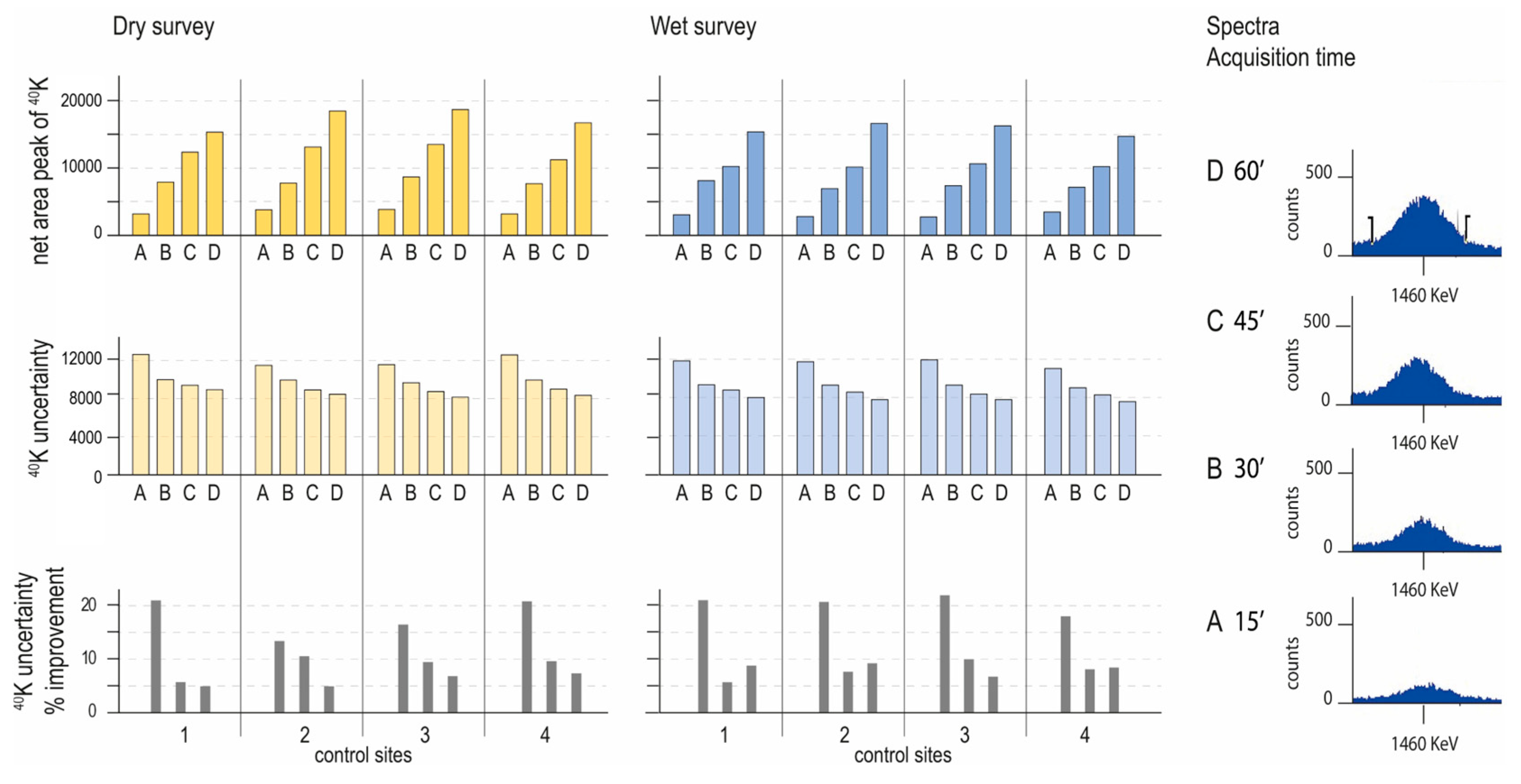
The results obtained from the stationary gamma ray spectroscopy (PGRS) during the dry and wet surveys, conducted before and after the rainfall event, respectively, showed clear and consistent differences in 40K gamma ray count rates and inferred soil water content (SWCPGRS) across all four sampling locations (1, 2, 3 and 4) within the 20 × 20 m plot. Under dry conditions, the 40K gamma ray count rates (cps) ranged between 3.5 and 5.2 cps across all points and acquisition times, while during the wet survey, they were markedly lower, with a range between 2.2 and 4.5 cps. This inverse relationship between gamma ray intensity and soil water content was reflected in the corresponding SWC values. While SWC during the dry survey remained below 0.30 cm3/cm3, the measurements taken after the rainfall event showed a pronounced increase, with values exceeding 0.5 cm3/cm3 in several cases.
Measurements at each of the four control points (
Table 1) indicated consistently higher
40K activity (Bq m
−2) under dry conditions compared to wet conditions. The uncertainty of the measurements, evaluated at intervals of 15, 30, 45, and 60 min, decreased progressively with increased acquisition time. The largest reductions in uncertainty occurred between 15 and 30 min, beyond which improvements in uncertainty became marginal. Specifically, average uncertainties decreased from around 21% at 15 min to approximately 9% after 60 min of measurement, indicating that a minimum measurement duration of 30–45 min provides the optimal accuracy–efficiency balance (
Figure 5).
Slight spatial differences between the four sampling points were observed. Under dry conditions, 3 and 4 exhibited the lowest SWC values, with an SWC around 0.07 cm3/cm3, while 1 showed comparatively higher values, reaching 0.51 cm3/cm3. However, the measurements taken at 15 min were associated with higher uncertainty, and more reliable estimates were obtained from acquisitions of 30 min or longer. Following the rainfall event, during the wet survey, control points 3 and 4 recorded the highest SWC values, exceeding 0.7 cm3/cm3, although these values gradually decreased with longer acquisition durations. These results reflected a slight spatial variability in soil moisture distribution across the plot.
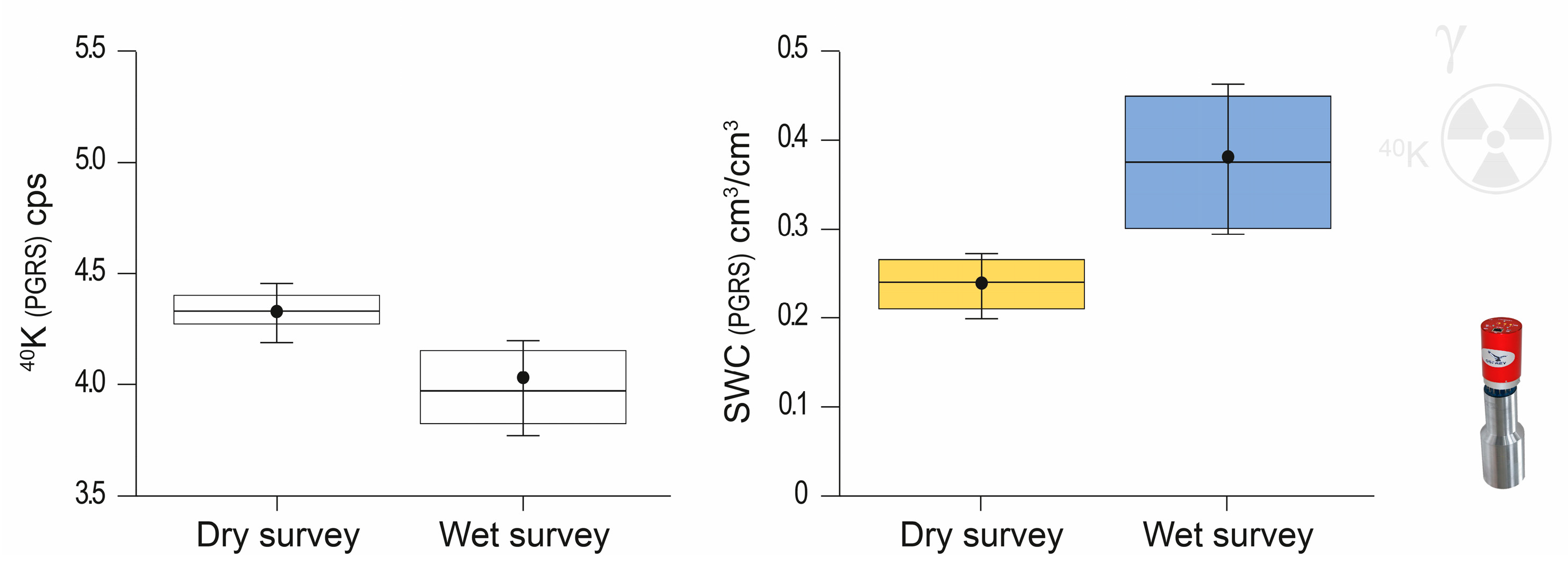
The mean
40K gamma ray count rates (cps) showed differences between dry (yellow) and wet (blue) conditions, with significantly lower cps values recorded during wet conditions (
Figure 6). The mean volumetric soil water content (SWC, cm
3/cm
3), derived from gamma counts, showed an inverse relationship with the cps data. The mean cps decreased from approximately 4.4 (±0.1) cps (dry) to 3.4 (±0.2) cps (wet), and the corresponding SWC increased notably from approximately 0.24 (±0.03) cm
3/cm
3 to 0.38 (±0.08) cm
3/cm
3. As expected, the lower
40K gamma ray count corresponded consistently to higher SWC values. The regression analysis confirmed the robust negative correlation between cps and SWC, further validating the effectiveness of gamma ray spectroscopy as a tool for soil moisture monitoring.
3.3. Field Probe SM200
The volumetric soil water content measurements obtained with the SM200 field probe (SWC
SM200) in the top 5 cm of the soil revealed significant differences between dry and wet conditions. As shown in
Figure 7, and
Table 2, the values recorded at the four control points (
n = 10) presented some variability during each survey, with greater dispersion observed under wet conditions. During the dry survey, SWC ranged from 3.8 to 10.4%, whereas during the wet survey, values substantially increased, ranging from 24.4 to 37.7%. The mean SWC
SM200 significantly rose from 6.3% to 30.1%, confirming a soil moisture increase after the rainfall event and aligning with the trends detected with both nuclear sensors, CRNS and PGRS, respectively.
3.4. Temporal and Spatial Variation in Water Content
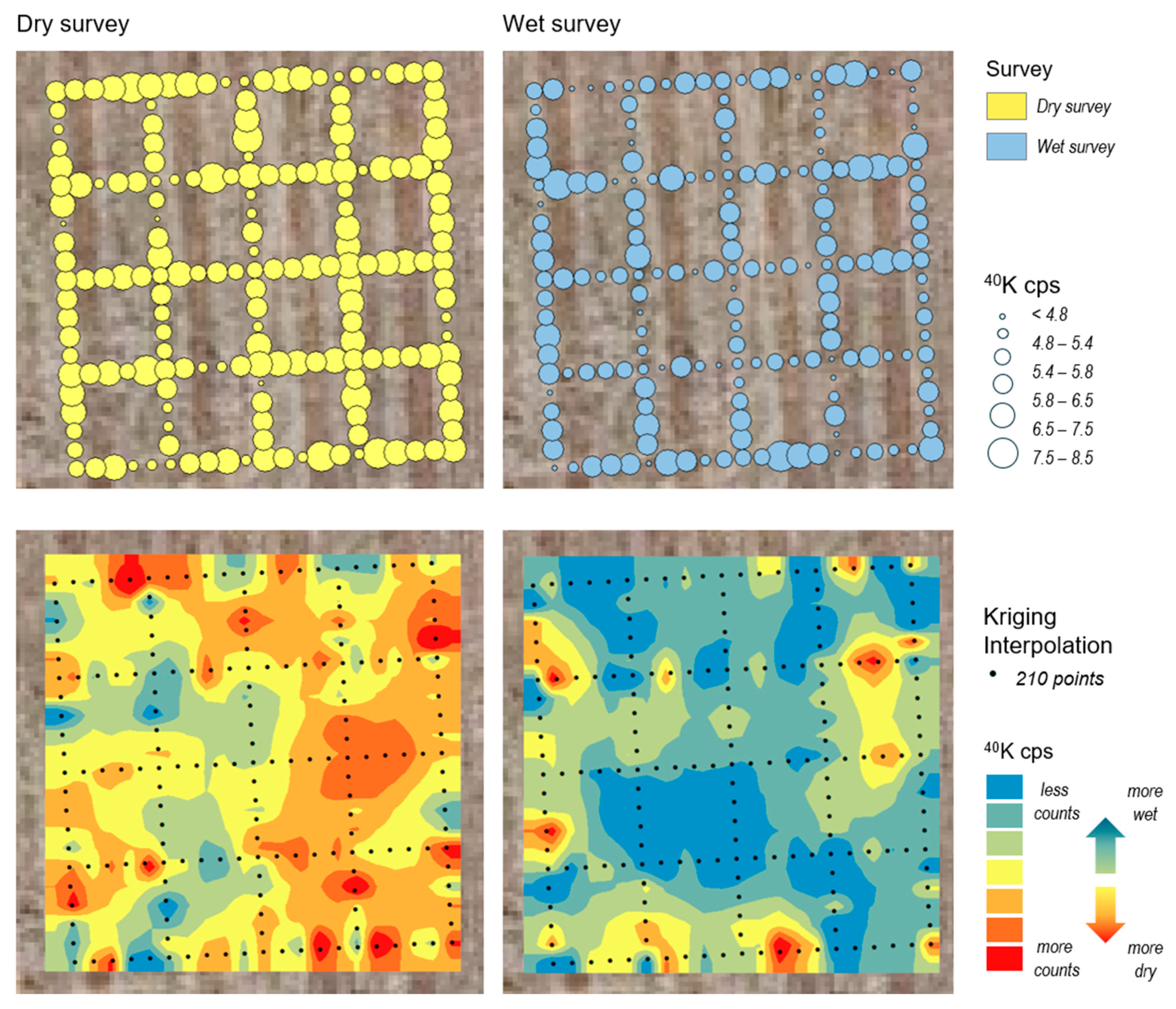
The mobile stop-and-go gamma survey, carried out across a 20 × 20 m plot with 1 m spatial resolution, produced a dense grid of
40K count rate (cps) measurements, enabling fine-scale mapping of the soil moisture variability. The results for both dry and wet surveys are presented in
Figure 8.
Distinct spatial and temporal patterns in 40K count rates were recorded between the two surveys. The dry survey recorded higher 40K count rates (mean 4.4 cps) compared to wet survey (mean 3.4 cps), consistent with dry soil conditions before the rainfall event and reflecting the inverse relationship between gamma ray intensity and soil moisture. The spatial analysis variability in 40K counts across the surveyed area identified localized differences in the soil moisture distribution before and after the rainfall event.
The observed spatial patterns suggest increased heterogeneity in soil moisture following precipitation. During the dry survey, 40K counts across the field were consistently high, mostly ranging between 4.6 and 5.5 cps (upper left map) indicating relatively uniform dry soil conditions. The central area and plot corners showed particularly homogeneous values, as reflected in the corresponding interpolation map (bottom left), where higher cps values dominate, especially in the centre and along the eastern and southeastern zones. These patterns are consistent with drier soil and align with previous static gamma measurements.
In contrast, the wet survey showed an overall reduction in 40K count rates compared to the dry survey, with a greater number of points falling within the lower rates (3.0 to 4.8 cps). The interpolated map (bottom right) revealed a widespread decline in gamma activity of 40K, particularly in the central and northern areas of the plot, where the lowest values were recorded. These zones correspond to areas of higher soil-moisture content and illustrate the sensitivity of the gamma sensor and its ability to detect spatial variations in soil moisture.
4. Discussion
The cosmic ray neutron sensor provided a reliable and temporally detailed characterization of the variation in soil moisture during the study period, effectively capturing the impact of a rainfall event on the soil moisture conditions. The results obtained from the cosmic ray neutron sensor (CRNS) demonstrate the suitability of this technique for continuous monitoring of soil moisture dynamics under semiarid field conditions. The hourly data series successfully captured the temporal evolution of soil moisture throughout the two-week period, including a clear response to the 16 mm rainfall event. Neutron count variations reflected the expected changes in soil moisture content, with a marked decrease in counts following the precipitation, in line with the inverse relationship between hydrogen presence in the soil and neutron flux, as reported in previous studies [
22,
23,
24].
The gamma ray sensor in stationary mode provided reliable
40K count rates under both dry and wet conditions. The evaluation of acquisition times shows that measurements conducted over a 30 min period offer an optimal balance between data reliability and operational efficiency, with a clear reduction in measurement uncertainty. The expected inverse relationship between gamma ray count rates and soil water content was clearly observed. Across the four control points, the
40K counts consistently decreased under wet conditions, while the corresponding SWC values increased. This response confirms the sensitivity of the PGRS to soil moisture variations, consistent with findings from other field scale studies [
10]. The slight differences observed between the four control locations also reflect small scale spatial heterogeneity in soil moisture distribution, effectively captured by the gamma ray sensor, which provided measurements at higher spatial resolution. In contrast, the CRNS offered an integrated signal representing the average conditions over the entire monitored area, incorporating small SWC variations. While the two sensors operate at different spatial scales, this distinction is not a limitation but rather highlights their complementarity. The use of both sensors in combination provides a more comprehensive understanding of soil moisture dynamics, as each offers distinct but complementary information at different scales.
The mobile stop-and-go gamma survey proved to be a very useful exploratory approach for assessing spatial variations in the gamma signal response under contrasting soil moisture conditions. Although soil water content (SWC) values were not derived from these measurements, the differences in
40K count rates between the dry and wet conditions suggest that the method is highly sensitive to changes in SWC, with a consistent response pattern observed in the interpolated spatial maps. Other studies employing vehicle-mounted systems with larger scintillation crystals, e.g., [
25], have demonstrated their effectiveness in capturing soil moisture variability at field scale, particularly in open and accessible terrains. These systems typically achieve smoother spatial coverage due to their continuous acquisition mode and extended detection capacity. However, detailed acquisition parameters such as integration time per unit distance or spatial resolution are often not reported, making direct comparisons with our stop-and-go approach difficult. In contrast, the stop-and-go method presented here, based on 10-s acquisitions at 1-m intervals, offers a portable and flexible alternative. This makes it especially suitable for areas with restricted access, such as terraced fields, hilly slopes or rugged terrain, where conventional vehicle-based on-the-go surveys may not be feasible. Our approach is particularly relevant for Mediterranean agroecosystems, where complex topography and fine-scale variability call for adaptable and high-resolution ground-based monitoring solutions.
Comparisons between mobile stop-and-go measurements and stationary PGRS showed consistent trends in 40K count rates, reinforcing the reliability and robustness of gamma ray spectroscopy to effectively capture spatial–temporal variations in soil moisture conditions. These findings strongly support the application of mobile proximal gamma ray spectroscopy (PGRS) for rapid and detailed field-scale assessments of soil moisture variability.
Proximal gamma ray sensors enable continuous, non-invasive SWC estimation at sub-field scale. These estimates are increasingly in demand for local-scale applications such as for high-resolution land surface models and decision-making in precision agriculture. However, despite the standardised methodology, challenges remain when applying it in field conditions. In our study, the equation proposed by [
21] was applied to estimate SWC; however, a more accurate estimation of SWC from gamma ray requires site-specific calibration [
26]. Other corrections, particularly regarding soil composition and biomass attenuation, could improve the accuracy of SWC measurements. Recent studies [
25] have shown that the commonly used mass attenuation coefficients and biomass correction factors may not fully capture the variability encountered in field environments, highlighting the need to refine current theoretical models [
21]. However, it has to be noted that this study was conducted on bare agricultural soil, with the absence of vegetation during the study period, and therefore biomass attenuation was not affecting PGRS measurements.
Our PGRS findings demonstrate the effectiveness of the gamma ray sensor in capturing both the temporal evolution and the spatial variability in the soil water content. The comparison between the dry and wet surveys confirms the sensitivity of the method to changes in soil moisture. Moreover, we found a good compromise for reliable measurements that made measurement acquisition affordable for a survey duration of a medium-scale for application in regular-sized agricultural plots, managed at the individual farm scale. These results support the use of PGRS as a robust and non-invasive technique for the field-scale estimation of SWC, particularly in contexts where spatial heterogeneity and temporal dynamics are critical, as in mountain agroforestry systems. The application of portable gamma ray systems, as demonstrated in this study, aligns with recent developments in lightweight spectrometry for precision field applications [
27]. While detector size and acquisition time influence sensitivity, the results obtained under the stop-and-go configuration confirm that reliable spatial patterns can be clearly identified. Similar portable detectors have been successfully used for high-resolution gamma surveys in environments where access by vehicle is restricted [
28]. These systems offer a valuable alternative for fieldwork in areas with limited accessibility, without compromising the ability to detect meaningful radiometric variations [
29].
While CRNS captures field scale dynamics, the portable gamma system allows detailed exploration of spatial heterogeneity. Together, they offer a complementary strategy and versatile application for monitoring soil moisture in heterogeneous agroecosystems. Our preliminary results from the stop-and-go surveys are promising and highlight the potential of this method for exploring the spatial patterns of soil moisture across agricultural plots. Together, both techniques offer a complementary and scalable strategy for soil moisture monitoring in heterogeneous and topographically complex environments.
Understanding the scale-dependent behaviour of soil moisture is critical for selecting appropriate monitoring methods for assessing SWC. Conventional techniques such as gravimetric sampling and capacitance sensors offer precise, localised measurements, but their limited spatial footprint and high labour demand restrict their ability to characterise soil moisture over larger or heterogeneous landscapes. In contrast, nuclear-based methods like cosmic ray neutron sensing (CRNS) and proximal gamma ray spectroscopy (PGRS) offer valuable alternatives with different but complementary capabilities. CRNS provides spatially integrated measurements that capture soil water content dynamics at the field scale, although with reduced sensitivity to local variation. PGRS provides higher spatial resolution at the metre scale, allowing for the identification of soil moisture variability driven by soil texture, topographic features and surface conditions. While CRNS is well suited for large agricultural fields managed uniformly, its footprint may be less suitable in areas with small, fragmented plots, such as those found in Mediterranean landscapes, where farming practices and soil conditions can vary significantly over short distances. In these contexts, sensors with smaller footprints, such as PGRS, become essential to accurately capture local variability. This strategy also aligns with the idea that local variability becomes increasingly smoothed at broader observation scales, underscoring the importance of combining large-footprint sensors with finer-scale methods to capture both dominant patterns and underlying spatial patterns. Integrating these methods helps address challenges related to spatial variability and anisotropy, as highlighted by [
30,
31], who emphasise that soil moisture often varies directionally due to natural heterogeneity and underline the importance of considering observation scale in measurement interpretation. Moreover, measurements obtained at the point scale often fail to represent broader landscape conditions. In this context, integrating CRNS and PGRS provides a valuable framework for characterising soil moisture patterns across multiple spatial scales. This approach supports the concept of scale representativeness and contributes to a more robust interpretation of spatial heterogeneity in semiarid agricultural environments.
Overall, both techniques demonstrated high sensitivity to soil moisture changes. The CRNS effectively captured temporal variability at the field scale, providing continuous and integrated SWC data across a larger footprint, while PGRS provided detailed spatial information, highlighting local variations in SWC within a smaller sensing footprint. Although inherent differences in detection depth and spatial footprint between these methods prevent direct numerical comparisons, our aim was to assess how each technique individually contributes to understanding soil moisture dynamics. By integrating the complementary strengths of CRNS and PGRS, we demonstrate the value of a combined approach, offering practical insights for precision agriculture, hydrological studies, and sustainable land management, especially in semiarid environments where capturing moisture variability at multiple scales is essential.
5. Conclusions
This study presents an integrated field assessment of two nuclear sensing techniques, cosmic ray neutron sensing (CRNS) and proximal gamma ray spectroscopy (PGRS), for monitoring soil moisture under contrasting conditions in a Mediterranean agricultural setting. The combined analysis under dry and wet conditions provided key insights into the sensitivity and complementary strengths of both approaches.
CRNS proved effective in capturing the temporal dynamics of soil water content at the field scale, offering continuous, non-invasive monitoring over the study period. PGRS, particularly in stationary mode with acquisition times of at least 30 min, delivered reliable 40K count rates with low associated uncertainty, allowing for accurate characterisation of soil moisture under variable conditions. Preliminary results from the mobile stop-and-go gamma surveys further indicate the potential of portable detectors for fine-scale mapping of soil moisture patterns. Although sensitivity may be influenced by short acquisition times, this method presents a flexible solution, relying on the ability to operate in complex or inaccessible environments, such as sloped fields or mountainous areas.
A key methodological perspective emerging from this study is the potential for integrating PGRS and CRNS observations. Our preliminary results showed that both techniques responded consistently to soil moisture changes under dry and wet conditions. This supports the idea that combining sensors with different spatial sensitivities may help to better capture soil moisture variability across scales, particularly in heterogeneous agricultural areas and in landscapes characterised by fragmented plots and diverse management practices.
Overall, the integration of CRNS and PGRS provides a robust and scalable framework for soil moisture monitoring. While CRNS integrates a 150–200 m signal, the PGRS enables detailed spatial exploration. Together, they offer a complementary strategy for understanding soil moisture variability across scales, with promising implications for precision agriculture, hydrological studies and land management in heterogeneous environments.


