Article

Settlement Characteristics and Control Methods for Highway Widening Using Weak Expansive Soil

1
State Key Laboratory for Tunnel Engineering, School of Qilu Transportation, Shandong University, Jinan 250012, China
2
Shandong Hi-Speed Group, Jinan 250101, China
*
Authors to whom correspondence should be addressed.
Appl. Sci. 2026, 16(6), 2977; https://doi.org/10.3390/app16062977
Submission received: 13 February 2026 / Revised: 13 March 2026 / Accepted: 18 March 2026 / Published: 19 March 2026
(This article belongs to the Special Issue Geotechnical Engineering and Infrastructure Construction, 2nd Edition)

Abstract

In highway widening projects, the wet–dry cycling effect of weakly expansive soil fill under seasonal groundwater fluctuations exacerbates differential settlement. This study establishes a three-dimensional numerical model for a widened road with weakly expansive soil, based on a redeveloped numerical method and actual engineering projects. Through multi-scenario numerical simulations, the influence patterns and weighting factors of widening methods, road height, and water level on differential settlement were clarified. Three safety levels for differential settlement were defined using 6 cm and 12 cm as thresholds. A prediction model based on support vector machines was established to determine the combined threshold limits of key parameters under different differential settlement boundaries. The control effectiveness of sand replacement, water-blocking layers, and wicking geotextiles was comparatively evaluated: sand replacement reduces differential settlement by approximately 70% on average and is applicable to all scenarios; water-blocking layers reduce settlement by about 50% and are more suitable for bilateral widening or unilateral widening of low embankments; wicking geotextiles are unsuitable for controlling differential settlement in high-water-level areas. Selection principles for control methods under different conditions were proposed based on engineering requirements, and field tests validated the effectiveness of the proposed solutions.

1. Introduction

With the continuous growth in traffic volume and the constant increase in vehicle loads, the capacity and load-bearing capabilities of some expressways have become inadequate to meet the demands of economic and social development [1]. Therefore, widening and upgrading existing expressways has become a key approach to enhancing road network efficiency and ensuring traffic safety [2,3]. The differential settlement between new and existing roadbeds in highway widening projects is a critical factor affecting pavement structural performance and long-term service safety [4,5]. Expansive soil is a special soil type commonly encountered in engineering projects, distributed widely across the globe. Due to its engineering properties of swelling when wet and shrinking when dry, it may pose significant risks to construction projects [6,7,8,9]. Highway widening projects are predominantly located in economically developed densely populated areas. In certain regions, high-quality fill materials may include weakly expansive soils (with free expansion rates ranging from 40% to 65%) for embankment construction [10]. When the subgrade fill material for road widening sections consists of weakly expansive soil sensitive to moisture changes, and seasonal fluctuations in the groundwater table occur, the wet–dry cycling effect will exacerbate the cumulative deformation and deterioration of the fill material’s mechanical properties, thereby complicating the formation mechanisms and the control of differential settlement [11]. Research on the long-term performance of weakly expansive soil fill materials under fluctuating groundwater conditions, particularly regarding the primary factors governing differential settlement in widened roadbeds, remains limited.
Due to the strong correlation between the engineering properties of expansive soil and its moisture content, and under the influence of natural environmental factors such as groundwater level fluctuations and rainfall, moisture changes in the subgrade are unavoidable [12,13]. To ensure the stability and safety of expansive soil subgrades, scholars have conducted extensive research in two areas: soil modification and subgrade moisture control [14,15]. Expansive soil modification encompasses physical, chemical, and biological modification methods. By incorporating other materials, the gradation, structure, and mineral composition of expansive soil are altered, thereby reducing its expansion and contraction characteristics. Primary materials include cement, lime, basalt fiber, and glass fiber [16,17]. In recent years, fly ash, rubber, and waste marble powder—all based on ecological conservation and solid waste utilization concepts—have also been successfully applied in expanding soil improvement [18,19,20,21,22]. Regarding subgrade moisture control, Chu Xuanxuan et al. examined moisture variation in subgrades under different operating conditions. They summarized the effectiveness and influencing factors of drainage methods such as permeable base courses, isolation drainage layers, and geosynthetic drainage layers [13]. Zhang Yaguo et al. investigated the effect of capillary barrier layers—composed of an upper fine-grained soil layer and a lower coarse-grained soil layer—on subgrade moisture content under dry and wet climatic conditions. The former layer exhibits a low permeability coefficient, while the latter effectively blocks capillary water pathways. The study demonstrated that subgrades incorporating capillary barrier layers exhibit a more stable moisture distribution field [23]. The aforementioned research provides theoretical foundations and key control technologies for highway widening projects. However, systematic findings remain lacking regarding quantitative safety evaluation methods for differential settlement and cost-effective control measures for widened subgrades constructed with weakly expansive soils and subject to groundwater fluctuation.
Furthermore, existing standards and practices lack a differential settlement analysis framework for road widening projects that accounts for the combined effects of soil moisture cycling and hydrological conditions. Therefore, identifying the primary factors controlling differential settlement in widened roads with weak expansive soils and proposing targeted cost-effective settlement control measures hold significant theoretical and engineering value for ensuring the quality and durability of high-grade highway widening projects. To address this, this study focuses on differential settlement issues in widened subgrades with weak expansive soils under seasonal groundwater level fluctuations. Through a redeveloped numerical method, long-term subgrade deformation under multiple operating conditions is simulated to reveal differential settlement patterns and quantify factor weights. Based on this, safety limits for differential settlement are defined, and the corresponding key parameter thresholds for different settlement limits are back-calculated. The effectiveness and applicability conditions of control techniques such as replacement fill and water-blocking layers are compared and analyzed. Finally, through engineering case validation, a comprehensive technical pathway is established—from mechanism analysis to control implementation—aiming to provide a theoretical basis and practical guidance for similar projects.

2. Materials and Methods

2.1. Project Background

This study is based on the expansion and renovation project of the Weihai to Yantai section of Rongwu Expressway. The local climate is temperate monsoon, with rainfall concentrated between June and August, accounting for 53% of annual precipitation. Groundwater levels are relatively high; according to geological survey data along the road route, the groundwater depth at multiple monitoring points is less than 0.5 m, generally ranging between 0.5 and 5 m. Furthermore, statistical data on groundwater depths in Weihai and Yantai cities indicate that in 2022, the average minimum water levels across different regions of the two cities were 3.23 m and 6.05 m, respectively, while the average maximum water levels were 1.73 m and 3.38 m. The average seasonal fluctuation in water levels was 1.5 m and 2.59 m, respectively. Driven by strong capillary action and temperature gradients, groundwater may infiltrate the fill embankment. Under the dry–wet cycles induced by seasonal water level fluctuations, this can cause fill material degradation, leading to localized damage and pavement cracking. This section has undergone multiple repairs. Following the initiation of reconstruction and expansion in 2022, differential settlement control has become a critical challenge. Therefore, targeted research is needed to provide theoretical guidance for settlement control and performance enhancement.

2.2. Numerical Model

To investigate the mechanisms of subgrade settlement and control effectiveness, a practical model was developed to address real-world engineering challenges. First, assuming the pore gas pressure remains constant, the constitutive model in this study utilizes data from triaxial shear tests. Substituting d ε x = d ε y = 0 into the unsaturated soil stress–strain constitutive equation yields
d ε z = 1 μ 2 μ 2 E 1 μ d σ z u a + 1 + μ H 1 μ d u a u w
In the equation, ε i represents the normal strain in the i -direction ( i = x ,   y ,   z ), μ is Poisson’s ratio, E and H denote the elastic moduli of the soil structure for net stress and suction stress, respectively, u a is the pore gas pressure, and u w is the pore water pressure.
Without considering the influence of wet–dry cycles on the water-holding characteristics of soil and using saturation ( S ) as the state variable rather than suction when calculating wet expansion and dry shrinkage deformation, the expansion coefficient β can be calculated.
β = ε z w 1 μ Δ S 1 + μ
Here, Δ S represents the change in water content.
To simulate soil deformation under coupled wet–dry cycles via different hydraulic pathways, E and β are functions of the wet–dry cycle amplitude ( A ), stress ( σ z ), cycle frequency (   N ), and saturation ( S ):
E = f s σ z ,   A ,   N
β = f w σ z ,   A ,   N ,   S
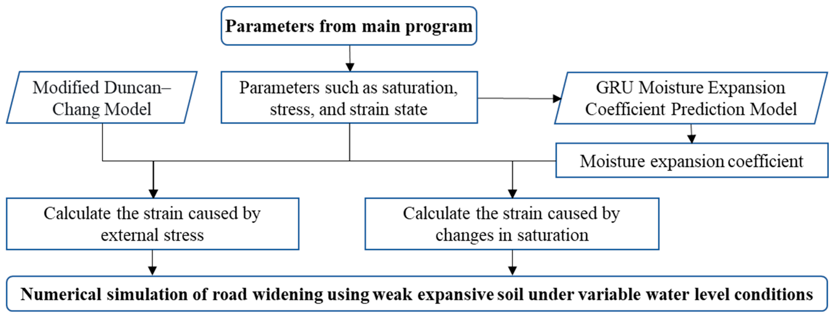
The constitutive framework described above was implemented using ABAQUS 2020. The modified Duncan Zhang model, previously established by the research group, was employed to calculate E . Detailed information regarding the theoretical model can be obtained from the published literature [24]. It was also compiled into a UMAT subroutine. The UEXPAND subroutine was utilized to simulate the swelling and shrinkage deformation of weak expansive soil. A machine learning prediction model for β was developed based on the GRU method from the research group’s prior work. Data used for β calculation and detailed information on the machine learning model can be found in the literature [10]. The UEXTERNALDB subroutine interacts with the GRU machine learning prediction model to update the expansion coefficient within ABAQUS during the calculation process. It is noteworthy that, during indoor wet–dry cycling tests, the lateral boundary conditions of the expansive soil vary during expansion and contraction cycles (e.g., during the first humidification expansion, it is in a laterally constrained state, whereas after multiple wet–dry cycles, the interaction between the soil’s wet expansion/dry contraction and lateral forces gradually weakens). To minimize errors, two calculation methods are employed for β : Formula (2) is used during the initial humidification phase, while Formula (5) is applied in other stages:
β = ε z w Δ S
The specific implementation process of the numerical method is shown in Figure 1.
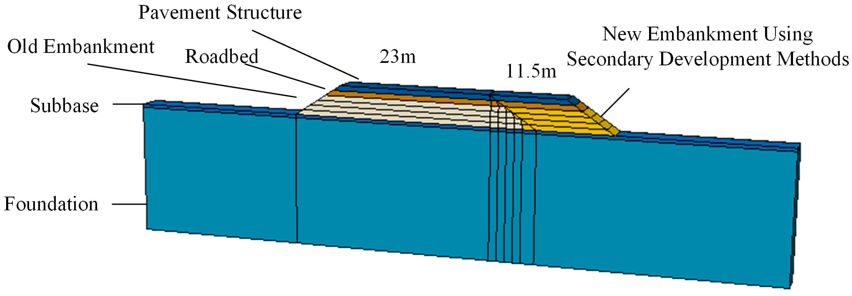
Based on the Rongwu Expressway design documentation, widening methods were categorized as unilateral and bilateral widening, with widening widths of 11.5 m and 5.75 m, respectively. The geometric model for the single-side widened road with a 4.8 m high is shown in Figure 2. From top to bottom, it comprises the pavement structure, roadbed, embankment, subbase, and foundation layers. Both the pavement and roadbed sections adhere to the Rongwu Expressway design standards, each with a thickness of 0.8 m. The embankment section comprises both new and existing embankments. After step excavation, the new embankment is constructed in layers. The embankment slope ratio is 1:1.5. During terrace excavation, the slope ratio for the old embankment terrace is 1:0.2. To fully reveal the long-term deformation characteristics of the widened road, the foundation section extends horizontally and vertically by 50 m and 20 m, respectively, comprising a 0.5 m subbase layer and 19.5 m of foundation soil. The depth along the road direction is set to 4 m. Water levels are defined through pore water pressure boundary conditions. The element type is an eight-node hexahedral element (C3D8P).
Typical fill materials involved in the project include silty clay and sandy soil. The basic physical and mechanical parameters for both materials obtained from laboratory tests are shown in Table 1, with the test methods following the standard T/CECS 1337-2023 [25]. Both the permeability coefficient and dry density were measured when the soil reached the actual engineering compaction degree (95%). According to the Technical Specifications for Building Construction in Expansive Soil Areas (GB 50112-2013) [26], soils with a free expansion rate between 40% and 65% are defined as weakly expansive soils.
Among these, the pavement structure, subgrade, base course, and foundation were simplified based on the design data and geological survey information. The key parameter values are shown in Table 2 and Table 3. To simulate foundation drainage consolidation settlement, the modified Cambridge model was applied to the foundation. In Table 3, λ , κ , and M are all clay plasticity parameters.

2.3. Test Condition Design

Based on the design documentation for the widening project of the Weinan–Yantai section of the Rongwu Expressway, this study considered the following factors influencing road settlement during widening: the widening method, road height, and groundwater level. The groundwater level encompasses both the maximum and minimum water levels, with the depth of the water level being used to represent its height. The experimental variable values for different factors are shown in Table 4.
Based on the design data, the widened road height is generally less than 4 m. Considering the excavation depth of the second and subsequent terraces, the pavement structure, and the subbase, each layer was simplified to 0.8 m. Therefore, the maximum road height was set at 4.8 m, which is higher than most embankments, and decreased by 0.8 m per layer, with the minimum value at 2.4 m. The maximum and minimum water levels were determined based on road survey data and Yantai City’s water level statistics.

2.4. Experimental Design for Subgrade Deterioration Control Methods

To quantify the effectiveness of different control methods in suppressing the differential settlement of a widened road with weak expansive soils, this study selected three typical measures for comparative analysis: replacement with sandy soil, installation of a water-blocking layer, and the use of wicking geotextiles. The primary reasons for selecting these three measures are as follows. Given that the foundation has been properly addressed, the root cause of settlement lies in the expansion and contraction characteristics of the fill material coupled with humidity fluctuations. Therefore, the measures must focus on optimizing the fill material and controlling humidity. Simultaneously, practical engineering considerations were taken into account: soil replacement and waterproofing layers, as proven technologies, ensure reliability, while wicking geotextiles, as a novel material, explore the potential for active humidity regulation. Furthermore, considering the abundance of surrounding farmland and factors such as the environmental impact and construction complexity, soil improvement was not included in the considerations.
Based on the differing mechanisms of action for each method, data on their impact on key roadbed performance parameters or moisture distribution fields were obtained through laboratory testing and numerical simulation, thereby evaluating their settlement control efficacy.
The replacement method: Dry–wet cycling tests were primarily employed to investigate the deformation characteristics and mechanical parameter degradation patterns of high-quality sandy fill material under cyclic moisture conditions, thereby evaluating its stability advantages over weak expansive soil. To meet the requirements for road widening embankments, the soil was compacted to 95% compaction at its optimum moisture content (12.5%). The soil samples measured 39.1 mm in diameter and 80 mm in height. Specimens were placed in confined molds, with filter paper and permeable stones added sequentially to the upper and lower sections, followed by wet–dry cycling. During testing, the vertical specimen height was measured using a gauge to analyze the deformation.
The water-blocking layer method: Capillary water rise comparison tests were designed using lime-stabilized soil, cement-stabilized soil, sand layers, and gravel layers. Changes in the soil moisture content above different layer materials were monitored to evaluate their humidity control capabilities.
Wicking geotextiles: A soil-geotextile interaction numerical model was established using COMSOL Multiphysics 6.3. The model accounted for the geotextile’s capillary suction and drainage processes. By varying the geotextile burial width and its distance from the groundwater table, the model simulated and analyzed its regulatory effect on the moisture field of the subgrade soil, thereby evaluating the applicability and limitations of this method. The upper boundary of the soil column was defined as a Dirichlet boundary condition, with its saturation maintained as constant at the residual moisture content to simulate a constant evaporation boundary. The sides of the soil column were set as zero-flux boundaries for water, while the bottom was defined as a groundwater boundary. The horizontal and vertical permeability coefficients of the geotextile were 1 × 10⁻⁴ and 9.6 × 10⁻⁶, respectively. The conditions are shown in Table 5.

3. Results

3.1. Analysis of Factors Affecting Differential Settlement in Road Widening Projects

3.1.1. Impact of Widening Methods

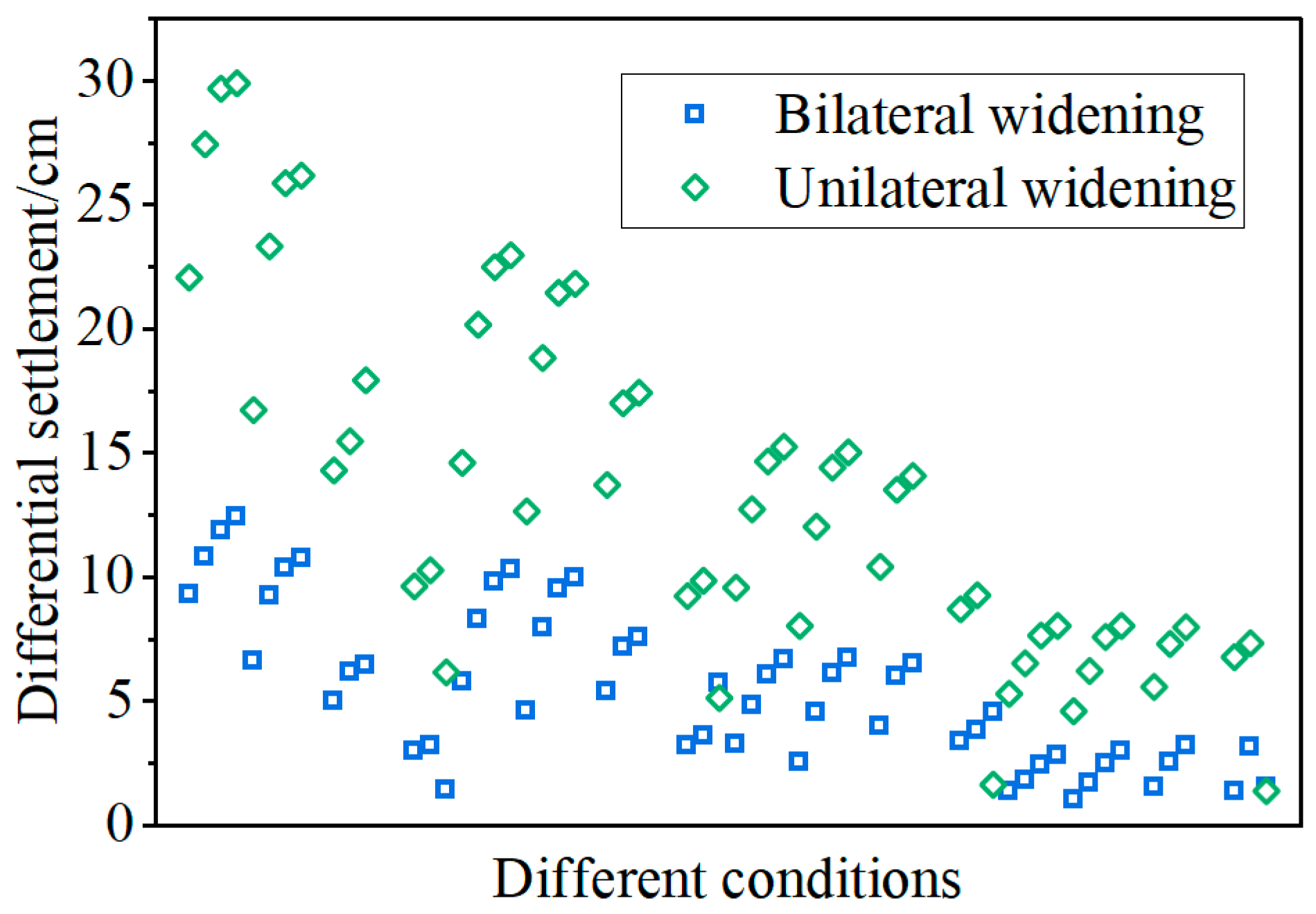
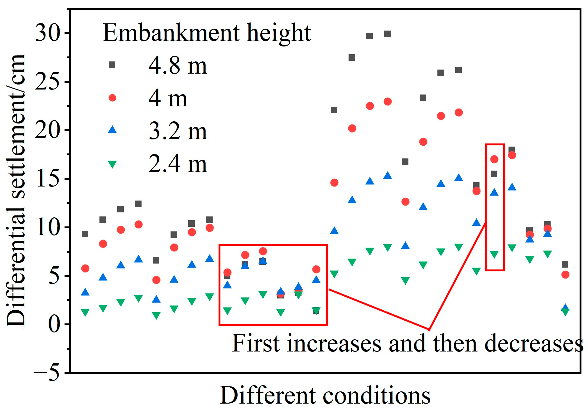
The widening method significantly affects the differential settlement. As shown in Figure 3, unilateral widening produces higher differential settlement, mostly ranging from 5 to 30 cm. In contrast, bilateral widening significantly reduces the differential settlement, with most values below 10 cm. When the road height is 4.8 m, and the groundwater level is between 0 and 4 m, the settlement difference between unilateral widening and bilateral widening reaches its maximum, at 17.8 cm. On the Rongwu Expressway, the new pavement width for bilateral widening is 5.75 m, while unilateral widening requires an 11.5 m pavement width. Bilateral widening distributes additional loads symmetrically across both sides of the existing subgrade, reducing the stress concentration and effectively mitigating the differential settlement.

3.1.2. Impact of Road Height

As shown in Figure 4, overall, the higher the road elevation, the higher the differential settlement. However, under bilateral widening conditions, when the road height increases from 2.4 m to 4.8 m, the differential settlement in some scenarios first increases and then decreases. This occurs because the load distribution range of a higher roadbed is broader, reducing the stress concentration. In contrast, during unilateral widening, a smaller proportion of the load is transferred to the existing roadbed, and the increasing road height typically directly causes larger settlement deformation.

3.1.3. Impact of Groundwater Level

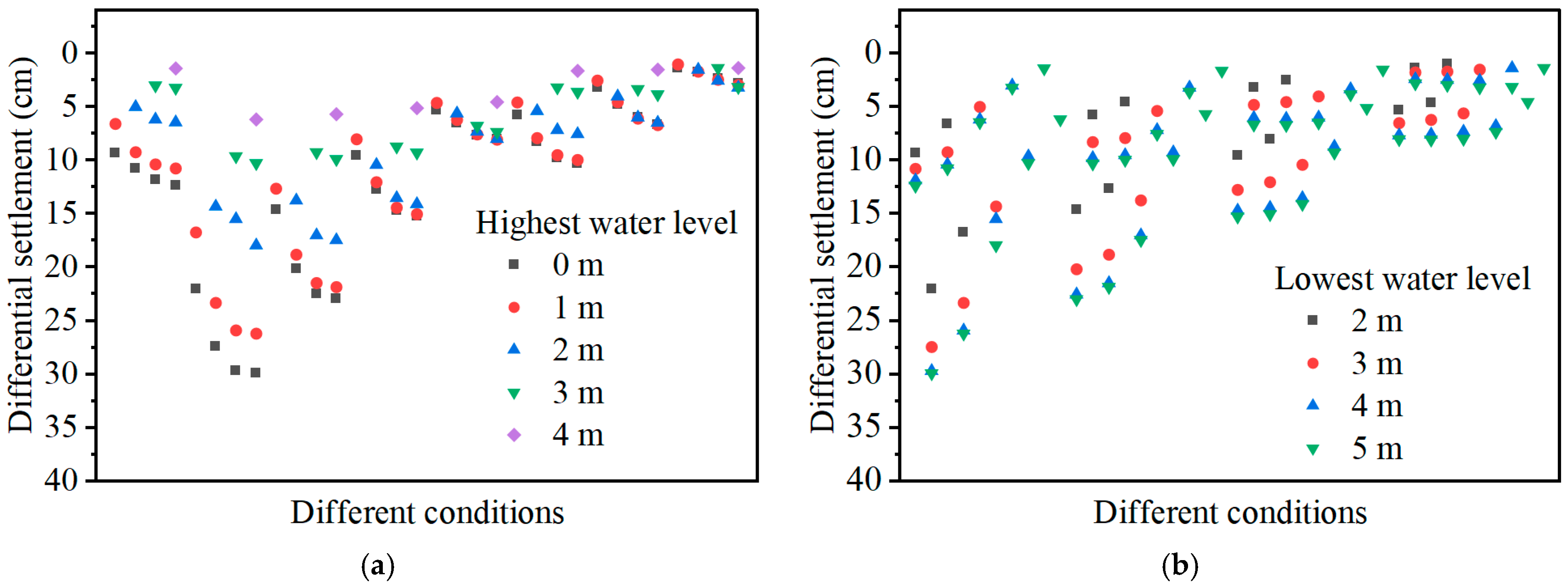
Figure 5 illustrates the effect of the groundwater level on the differential settlement during road widening, encompassing the influence of the highest and lowest water levels. As shown in Figure 5, the differential settlement increases as the burial depth of both the highest and lowest water levels decrease (i.e., water levels rise). When the highest water level reaches 0 m (water level at the base of the roadbed), the differential settlement can exceed 30 cm; while at a highest water level depth of 4 m, the differential settlement decreases to approximately 5 cm. Comparing Figure 5a and Figure 5b, the impact of the maximum water level variation on the settlement is significantly larger than that of the minimum water level. Furthermore, the variability and fluctuation range of the differential settlement also increase. Higher groundwater levels increase the moisture content of fill mate-rials and amplify the wet–dry cycling of weakly expansive soils, leading to higher cumulative deformation.

3.1.4. Multifactorial Comprehensive Analysis

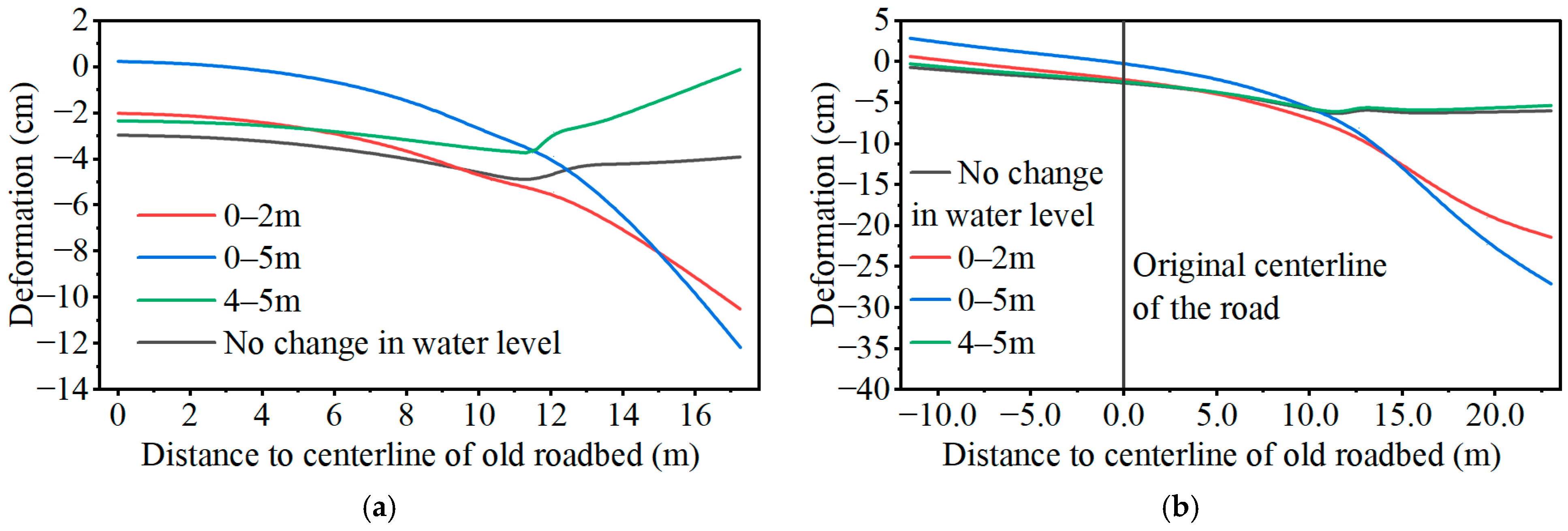
Figure 6 shows the settlement curves of the pavement under different operating conditions. The figure indicates that without water level changes—i.e., disregarding the effects of weakly expansive soil and groundwater—differential settlement still occurs between the new and old subgrades, with the maximum settlement occurring at the joint between them. However, when groundwater levels fluctuate between 0 and 2 m or 0 and 5 m, the mechanism of differential settlement between the new and old subgrades changes. The maximum settlement shifts from the joint to the shoulder of the new subgrade. Furthermore, due to the degradation and cumulative deformation of weak expansive soil under repeated wetting and drying cycles, the differential settlement between the new and old subgrades ultimately increases. Notably, when the water level fluctuates between 4 and 5 m, the pavement settlement deformation pattern resembles that without water level changes. At this point, groundwater has a minor impact on changes in subgrade moisture content and does not fundamentally alter the differential settlement mechanism. However, as shown in Figure 6a, compared to no water level variation, the shoulder of the new subgrade bulges upward under 4–5 m water level fluctuations, whereas the road center (i.e., the old subgrade) gradually bulges upward under 0–5 m variations. This occurs because weak expansive soil undergoes cyclic stresses during repeated expansion and contraction, inducing irreversible cumulative plastic deformation in the foundation.
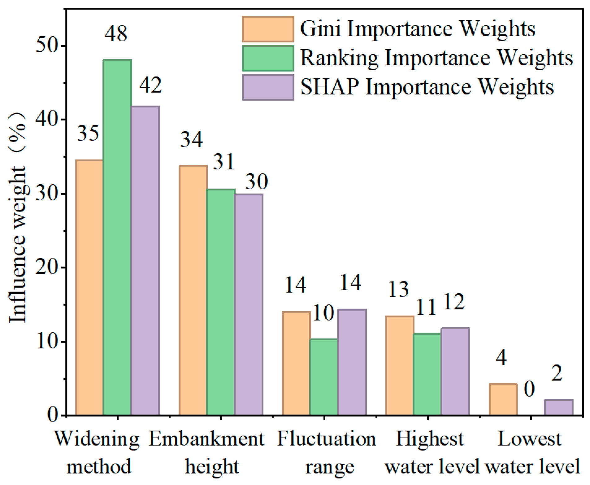
Feature importance analysis was conducted using a random forest regression model and the SHAP interpretability method. The arithmetic mean of the Gini weights, permutation weights, and SHAP weights obtained from both methods was calculated to derive the comprehensive weights for different influencing factors. Among these, the water level was considered as an influencing factor not only based on the highest and lowest water levels but also on the water level fluctuation range. The relative weights of different influencing factors are shown in Figure 7. The figure indicates that the influence of factors, from highest to lowest, is the widening method, road height, water level fluctuation range, highest water level, and lowest water level. Their composite weights are 41.5%, 31.4%, 12.9%, 12.1%, and 2.1%, respectively. In the study by Xu et al. (2025), the differential settlement of unilateral widening under the most unfavorable conditions was six times that of bilateral widening [4]. In the present study, the maximum differential settlement of unilateral widening reached five times that of bilateral widening. The widening method is one of the primary factors influencing the differential settlement.
The widening method and road elevation exert the largest influence on the differential settlement in weak expansive soil subgrades. Thus, when widening significantly or elevating the road, the use of weak expansive soil fill should be avoided whenever possible, or appropriate control measures should be implemented. The maximum water level exerts a significantly larger influence than the minimum water level. Furthermore, when the minimum water level falls below a certain threshold, its variation has a negligible effect on the differential settlement. Therefore, in practical engineering applications, more emphasis should be placed on the maximum water level, treating it as the primary controlling factor, while considering the minimum water level as a supplementary parameter to the maximum water level or the water level variation amplitude.

3.2. Safety Grade Classification and Engineering Parameter Inversion

3.2.1. Safety Grade Classification for Differential Settlement in Road Widening Projects

This study adopts differential settlement as the control criterion to evaluate the safety grade of roads constructed on weakly expansive soils under varying water level conditions. In recent years, scholars have analyzed the impact of various factors on differential settlement control standards by considering the pavement structure and functionality through finite element methods and model tests. Under different conditions, relatively safe differential settlement standards of approximately 6 cm and cross-slope control standards of around 0.4% have been obtained [27,28,29]. According to the design documentation for the Rongwu Expressway, the widened subgrade crown width is 34.5 m. Calculated based on a 0.4% cross-slope gradient, the differential settlement amounts to 13.8 cm—significantly higher than the 6 cm differential settlement value. Considering its status as a high-grade highway, the standard is further elevated to control the differential settlement using a 0.35% slope ratio, corresponding to a 12 cm differential settlement. Ultimately, this paper adopts 6 cm and 12 cm as the lower and upper limits for differential settlement control standards, corresponding to slope ratios of 0.17% and 0.35%, respectively. Differential settlement is thus categorized into three grades, as shown in Table 6. When the differential settlement is classified as Level I, the subgrade structure is considered sound and unlikely to fail structurally. No intervention or only minor treatment is required. For Level II differential settlement, appropriate measures must be taken to reduce the settlement until the post-construction settlement reaches the safety threshold. Level III differential settlement warrants serious attention, necessitating the combination of multiple treatment methods.

3.2.2. Inversion of Engineering Parameters Based on Machine Learning Models

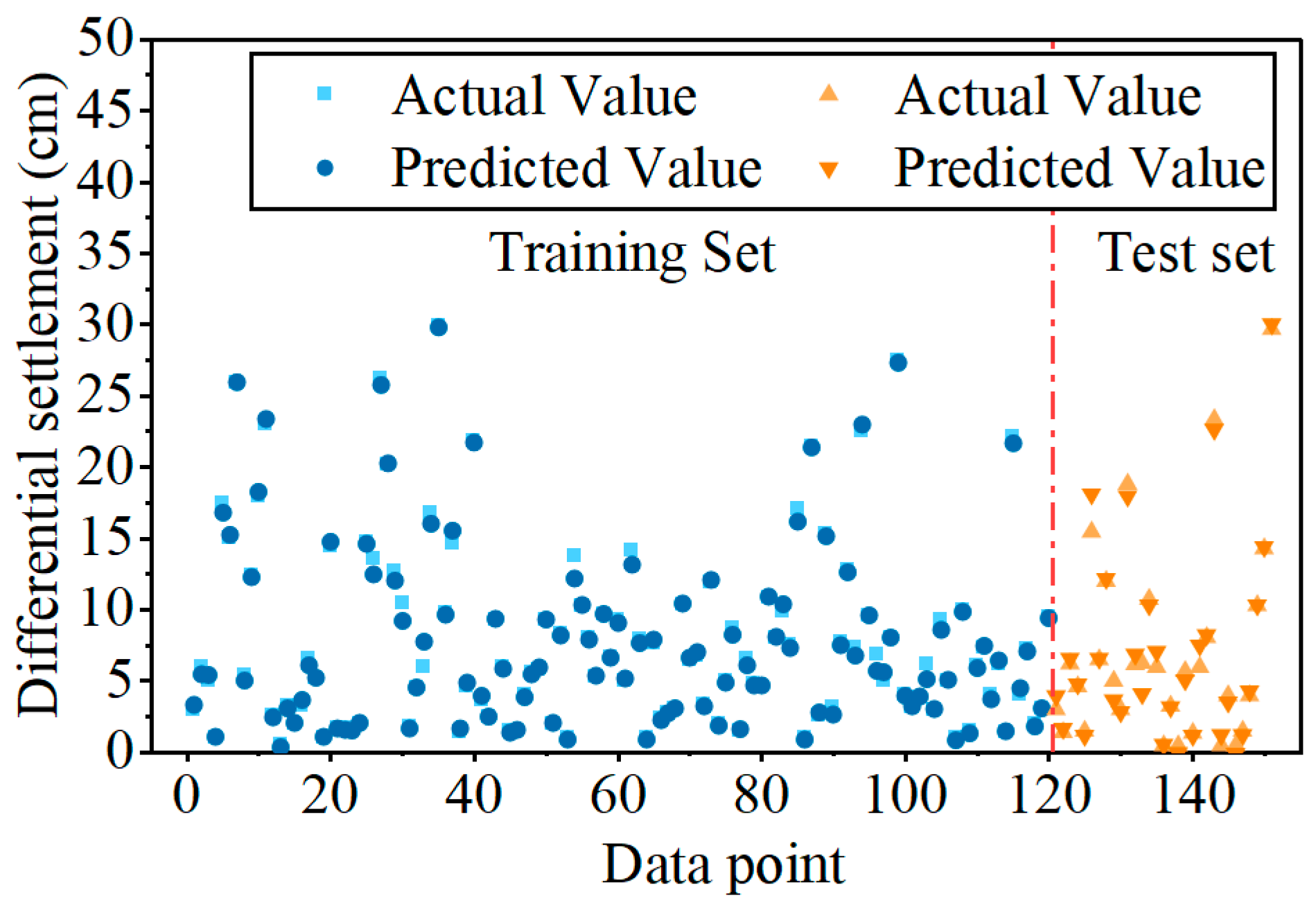
This study proposes an inversion analysis framework integrating data-driven approaches with intelligent search. Machine learning models establish mappings between various influencing factors and differential settlement values. Using 6 cm and 12 cm differential settlements as thresholds, the framework then infers the optimal values for different influencing factors under various operational conditions. The machine learning model employs the support vector machine (SVM) algorithm, with training results shown in Figure 8. The figure demonstrates the model’s strong performance on both training and test datasets, achieving R2 values of 0.99 and 0.98 respectively.
Considering that the widening method is fixed in actual engineering projects, the inversion process was conducted for four scenarios: unilateral widening and bilateral widening, combined with differential settlement thresholds of 6 cm and 12 cm. Physical constraints were applied to the minimum water level (0–6 m), maximum water level (0–5 m), and road height (0–4.8 m) based on the actual conditions.
By integrating Bootstrap models to optimize the inversion process, we first performed random sampling with replacement from the training set to generate 50 equally sized subsamples. An SVM regression model was trained on each subsample, yielding 50 independent SVM models that constituted the Bootstrap model ensemble. Next, predictions were made for different operating conditions. The model ensemble provided 50 predicted values, with the final prediction being the mean. The prediction standard deviation served as a measure of uncertainty. The 90% prediction interval was defined by the 5th and 95th percentiles. During engineering parameter inversion, the absolute error between the predicted mean and the target settlement (6 cm or 12 cm) must not exceed 0.1 cm. Additionally, the predicted standard deviation must be ≤0.5 cm to ensure the selected operating condition possesses high prediction confidence.
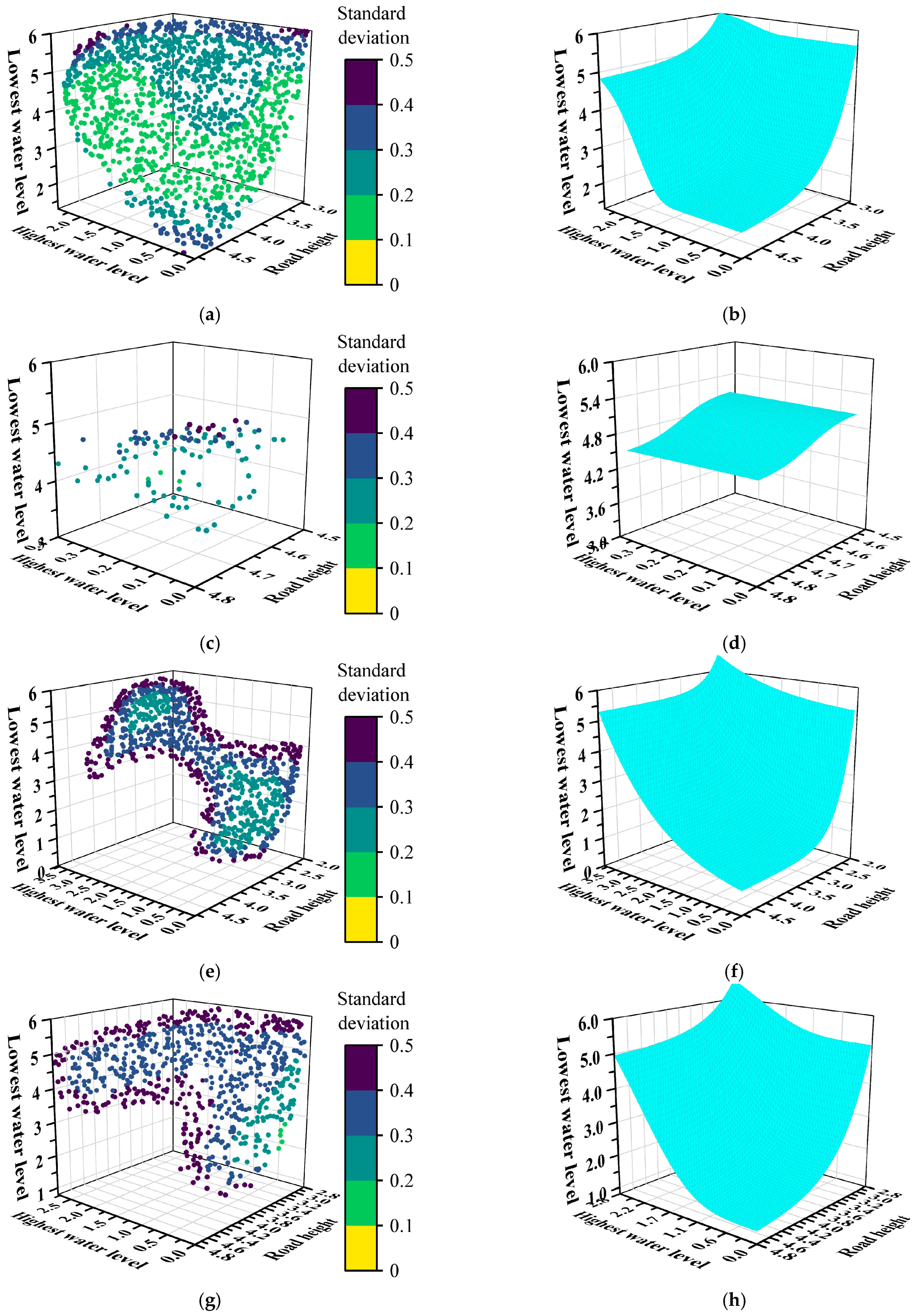
Figure 9 shows the combination of influencing factors for differential settlement boundaries and the fitted surfaces derived from the inversion results and a road height from 0 to 4.8 m. Based on the inversion results, the combinations of factors influencing differential settlement limits and the fitted surfaces are shown in Figure 9. Figure 9a,b present the inversion data and fitted surfaces under bilateral widening conditions with a differential settlement limit of 6 cm. For the fitted surface, when other factors are constant, the differential settlement exceeds the limit if any of the following conditions occur: the road elevation exceeds the fitted surface, the burial depth at the highest water level is less than the surface, or the burial depth at the lowest water level is higher than the surface.

3.3. Methods for Controlling Subgrade Deterioration and Analysis of Settlement Control Effects

3.3.1. Study on Settlement Control Effects of Different Measures

(1)
Replacement method
According to the research team’s preliminary findings, under wet–dry cycling conditions, the deterioration in strength and cohesion of sandy soils is relatively minor [30]. Additionally, soil volume monitoring revealed that during wet–dry cycles, the deformation (vertical height change) of sandy soil remained below 2% at different moisture contents, indicating minimal cumulative deformation. After multiple cycles, when the moisture content of sandy soil matched its initial value, the cumulative deformation was less than 1%. This makes it an excellent alternative fill material with outstanding stability.
(2)
Water-barrier layer
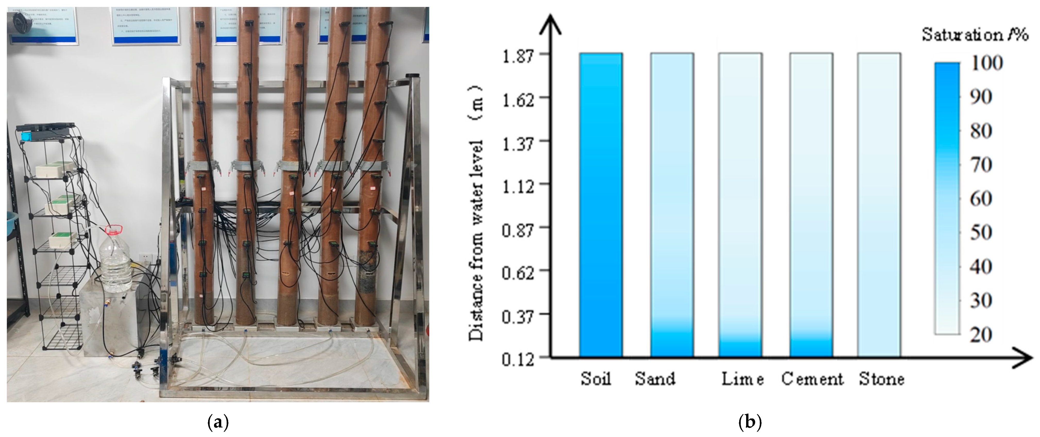
The experimental process and results are shown in Figure 10. From left to right within the different acrylic tubes are native soil, sand layer, lime-stabilized soil layer, cement-stabilized soil layer, and a crushed stone layer.
Based on observations and sensor monitoring data, the sand subgrade effectively blocks capillary water. However, after 60 days of observation, the capillary water level had risen to 22 cm above the subgrade, and the moisture content of the soil above the sand subgrade showed a slight increase. In the cement- and lime-stabilized soil subgrades, the capillary water rose slowly. After 60 days, the capillary water had not exceeded the subgrade level but continued to rise. The final capillary water rise height in the gravel cushion layer was approximately 10 cm. Therefore, cement and lime-stabilized soil cushions can delay capillary water rise, while sand and gravel cushions can block it. When the sand cushion layer is insufficiently thick, capillary water may rise above it. These findings are consistent with those reported by Huo et al. (2022) [31]. It is worth noting that, in the study by Huo et al. (2022), the control effectiveness of lime-amended soil was significantly influenced by soil compaction; when the soil compaction reached 92% or 94%, the moisture content of the overlying soil increased significantly [31]. In this study, with the soil compaction set at 95%, the lime-amended soil demonstrated superior control effectiveness.
Notably, as shown in Figure 10b, the moisture content decreased in some soil layers above the subgrade compared to the initial state. This was due to evaporation at the top of the soil column and near the sensors. Subbases primarily address rising groundwater capillary action but cannot prevent moisture migration from rainfall or between old and new subgrades. Consequently, the soil still undergoes some degree of wet–dry cycles. The subsequent studies assume that even after subbase installation, weakly expansive soils still experience limited wet–dry cycles.
(3)
Moisture control effectiveness of wicking geotextiles
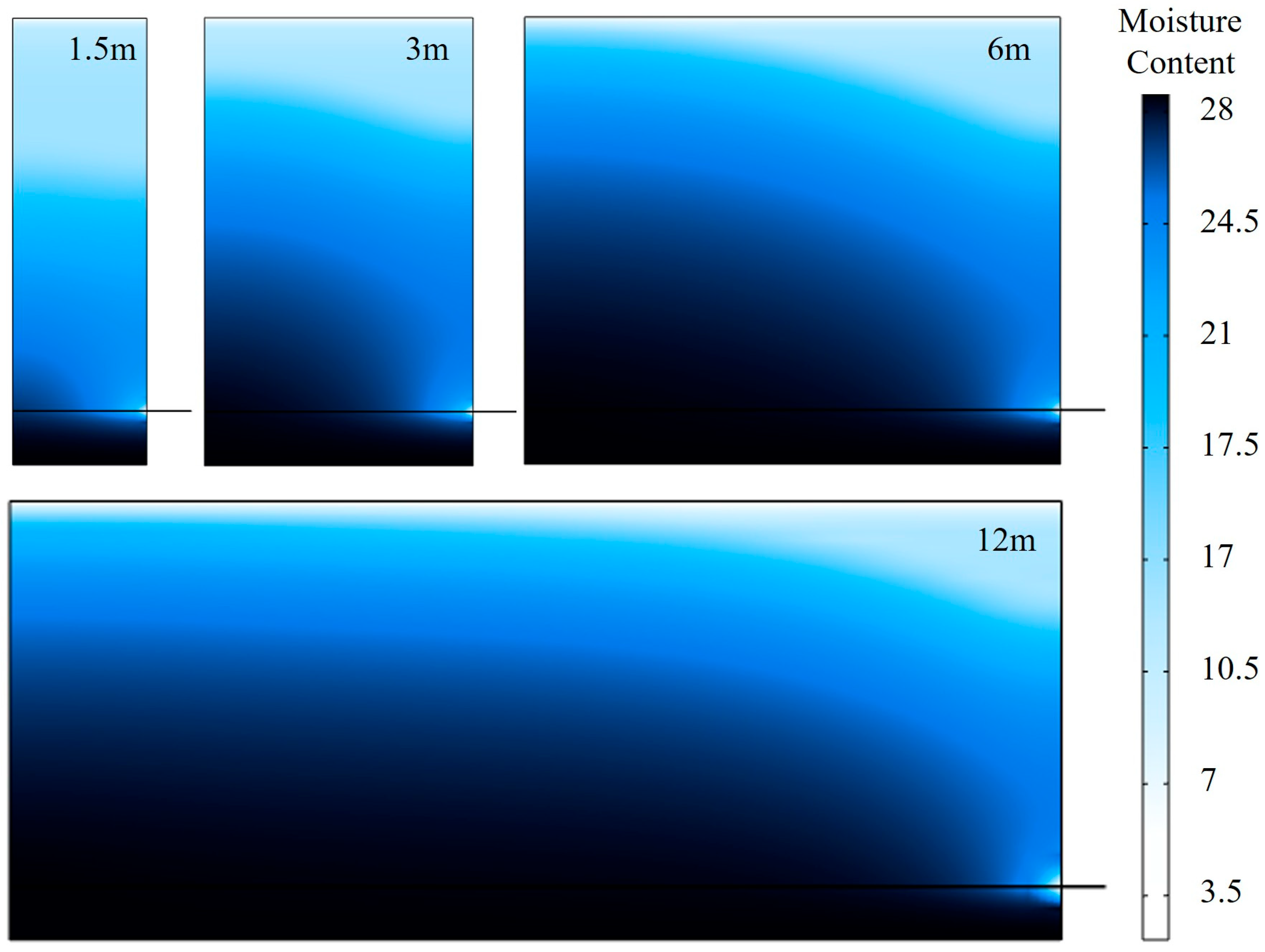
Figure 11 illustrates the influence of the fabric burial depth and width on the soil moisture field. When the fabric width is 6 m and 12 m, it approximates the soil widths for bilateral widening and unilateral widening, respectively. As the width increases, the lateral distribution range of the capillary water zone expands significantly, forming an arc-shaped wet zone extending from the bottom toward the middle. The overall moisture content gradient becomes more gradual. A larger soil width correlates with a higher overall moisture content, particularly in the interior soil (further from the fabric’s drainage boundary). This occurs because the fabric’s drainage capacity is constrained by the evaporation rate of its exposed portion and the horizontal permeability coefficient. As the fabric’s burial width increases, the contact area between soil and fabric grows, allowing more water to migrate from the soil to the fabric. However, the fabric’s drainage capacity has an upper limit. Moreover, moisture near the drainage boundary is more readily discharged, while moisture in the interior soil requires a longer migration path to exit. Consequently, the soil near the fabric drainage boundary exhibits a significantly reduced moisture content, whereas the moisture content of the deeper soil is less affected.
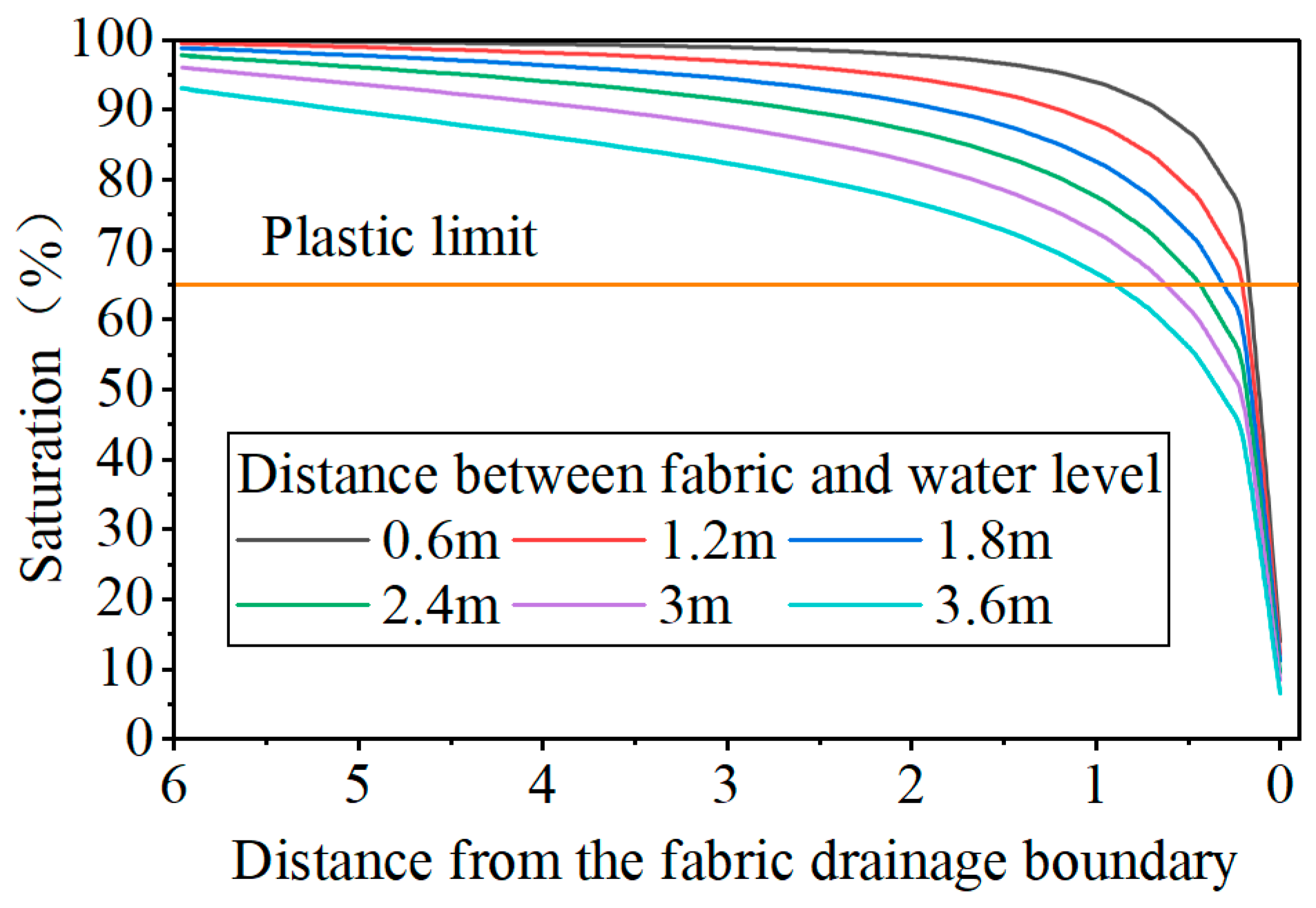
Figure 12 shows the effect of the distance between the geotextile and the groundwater level on the soil moisture field. The curves represent the relationship between the moisture content of the soil 5 cm above the geotextile and the distance from the drainage boundary of the geotextile. The figure indicates that when the geotextile is located 0.6 to 3.6 m above the groundwater level, it cannot directly control the moisture content of the overlying soil below the plastic limit. However, based on the inversion results in Section 3.2.2, when the water table is below 3.5 m in the subgrade, the differential settlement in weakly expansive soil subgrades is minimal and meets the safety requirements. Therefore, in subsequent studies of this paper, the capillary water control effect of wicking geotextiles in high-water-table areas will not be considered.

3.3.2. Prediction of Differential Settlement in Road Widening After Control Measures

Based on the effects of the aforementioned measures on the performance or moisture field of the new fill embankment, further simulations of differential settlement in the widened embankment considering control measures were conducted. The simulation conditions were selected from representative scenarios in Figure 9, representing different differential settlement control standards. These included combinations of boundary conditions corresponding to maximum or minimum values for the road height and the maximum/minimum water level burial depth when the differential settlement reached 6 cm or 12 cm, the projected average center point of the fitted surface, and the most unfavorable scenario. During numerical simulation, sandy soil in the replacement method was modeled using an elastic–plastic constitutive relationship, disregarding its dry–wet cycle deterioration effect. When a cushion layer is applied, the dry–wet cycle amplitude for weakly expansive soils is set to 3% (twice the difference between optimum moisture content and equilibrium moisture content). This accounts for factors affecting the moisture field, such as moisture migration between new and old subgrades and atmospheric rainfall. The moisture content of the new subgrade fill fluctuates around the optimum moisture content and tends toward equilibrium moisture content, disregarding direct capillary water effects from groundwater.
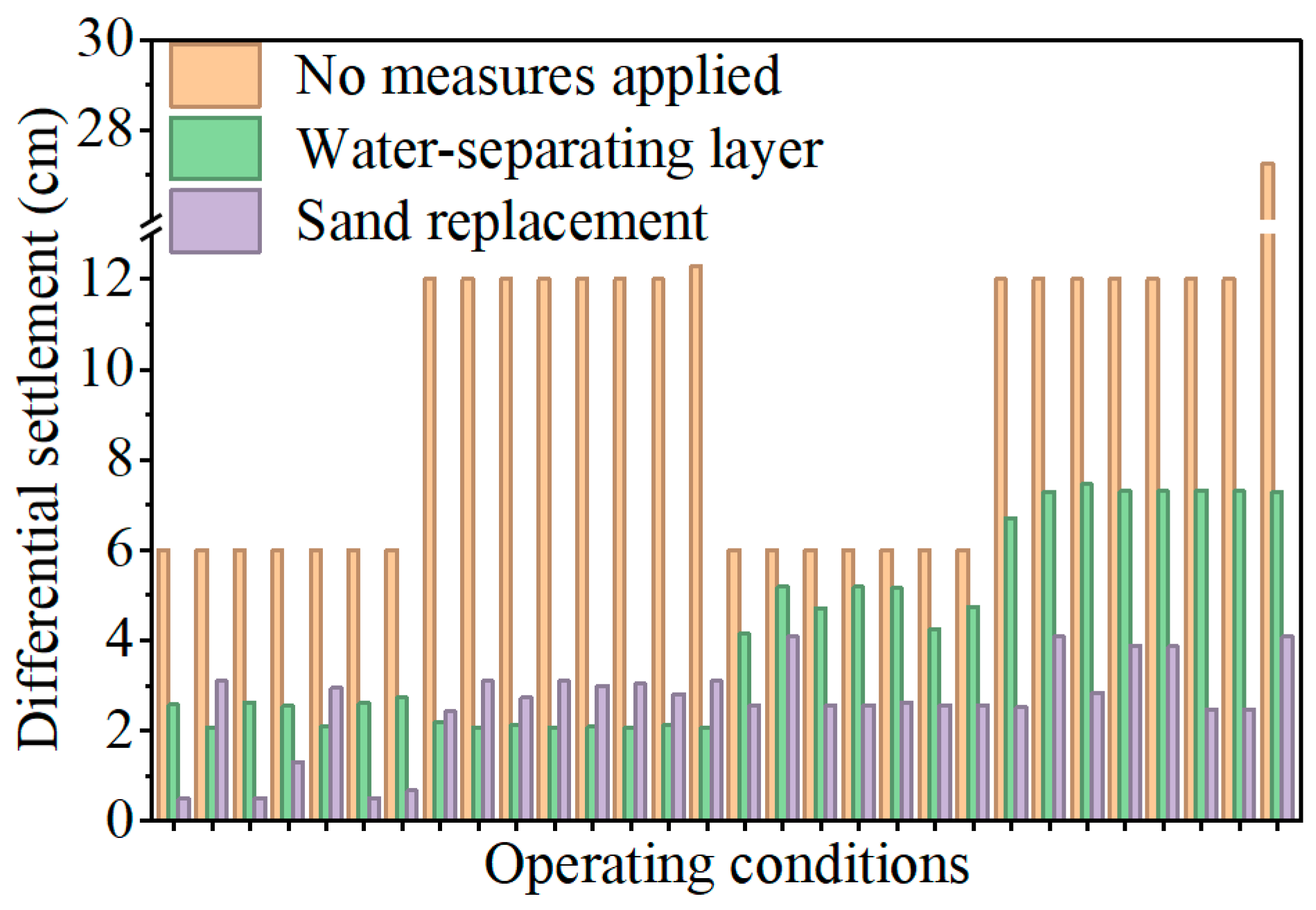
The effects of different control measures on the differential settlement in widened roads are shown in Figure 13. The figure indicates that applying control measures significantly reduces the differential settlement in widened roads. Replacing the soil with sandy soil proves more effective than using a water-blocking layer, with both methods reducing the differential settlement by an average of 50% and 70%, respectively, under different operating conditions. Notably, when bilateral widening was implemented, both methods reduced the differential settlement to below 6 cm. For unilateral widening, replacing with sandy soil reduced differential settlement below 6 cm, while adding a water-blocking layer only partially reduced the settlement below 6 cm for road sections with lower elevations. For combinations operating at the upper limit of differential settlement (12 cm), the settlement remained between 6 and 12 cm even with the water-blocking layer. This occurs because, although the water-blocking layer effectively inhibits capillary action, factors like moisture migration between old and new subgrades and atmospheric precipitation influence the moisture field. Consequently, weak expansive soil subgrades undergo cumulative deformation during long-term service, particularly pronounced in wider widening sections and higher road elevations.

3.3.3. Engineering Application

An engineering application was conducted on the bilateral widening section at K121+400 of the Rongwu Expressway Weiyan Section. This section features a 4.5 m road height, with a groundwater level burial depth of 1.71 m during the survey period and a water level fluctuation range of approximately 3 m. Based on the research in Section 3.1 and Section 3.2, the differential settlement was predicted to be 8.3 cm, exceeding the 6 cm settlement control standard. Following the control scheme in Section 3.3.2, a gravel cushion was added to isolate the capillary water effects. Given the soft soil foundation, CFG piles were employed for treatment, ultimately installing a 40 cm thick gravel cushion.
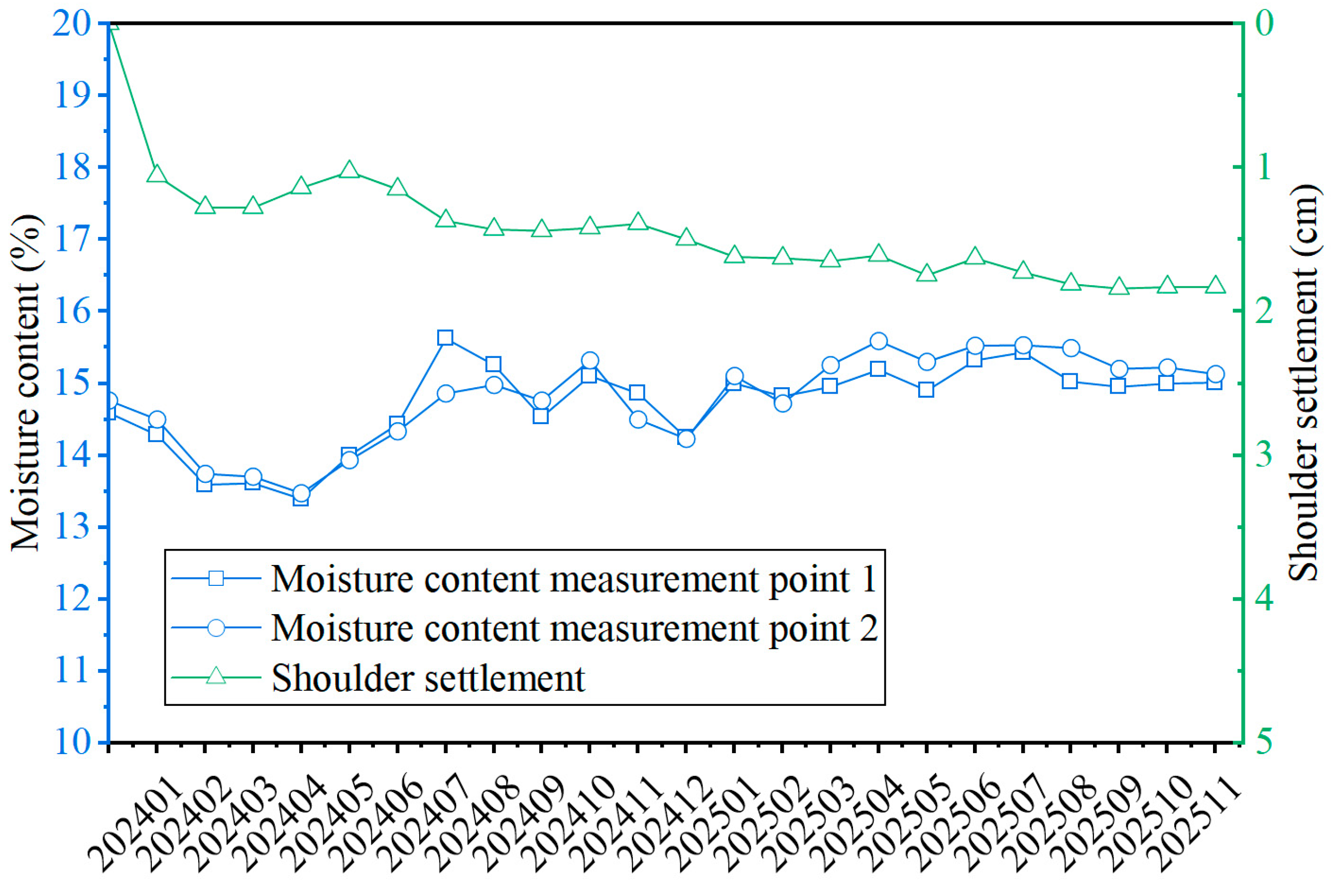
Post-construction monitoring of the moisture content in the new roadbed and settlement at the shoulders was conducted after implementing the control measures. Moisture monitoring points were located 13 m from the road centerline, at depths of 2.5 m and 3 m below the pavement surface. The field monitoring results are shown in Figure 14. The figure indicates well-controlled post-construction settlement, with the shoulder settlement measuring approximately 1.83 cm. The moisture content of the new roadbed first decreased and then increased, with the long-term moisture content slightly higher than that during filling. Furthermore, it was not subject to strong capillary water effects caused by groundwater. After implementing control measures, the shoulder settlement at K121+400 was minimal and did not exhibit significant fluctuations with water level changes. This verifies the effectiveness of the control methods in managing moisture, settlement, and differential settlement in the widened roadbed made of weakly expansive soil.

4. Discussion

4.1. Selection of Different Control Measures

Forward calculations and combinations based on limited case studies struggle to systematically and comprehensively provide specific engineering parameter combinations under different differential settlement limits. The inversion method proposed in this paper better captures the boundary conditions for different engineering parameter combinations under differential settlement limits. This provides a more effective reference for engineering design. By quantifying the control effectiveness of weak expansive soil treatment measures, it achieves differential settlement control for road widening projects involving weak expansive soil. Figure 9 clearly illustrates the combinations of different influencing factors under differential settlement limits of 6 cm and 12 cm. Since the minimum water level has a relatively minor impact, most scenarios still exhibit a differential settlement exceeding the limit even when the minimum water level burial depth reaches 6 m. For each differential settlement limit, corresponding thresholds exist for both the maximum water level burial depth and road elevation. When either the depth or elevation falls below these thresholds, the differential settlement also remains below the limit value. In most scenarios, these thresholds correspond to the minimum values within the coordinate range. As shown in Figure 9a,b, for bilateral widening, the thresholds for the maximum water level burial depth and road elevation are 2.5 m and 3 m, respectively.
The widening method, specifically the widening width, has the most significant impact on the differential settlement of roads widened with weak expansive soil. Therefore, bilateral widening should be selected whenever possible. The higher the road elevation and groundwater level and the higher the fluctuation range of the water level, the more attention should be paid to differential settlement issues in embankments widened with weakly expansive soil. When using weakly expansive soil for filling, the initial moisture content of the fill material can be controlled around 16% during compaction to reduce post-construction deformation. The selection of settlement control methods under different conditions is as follows.
For bilateral widening, use weak expansive soil fill without additional treatment when the maximum groundwater level depth exceeds 2.5 m or the road height is less than 3 m. For all other conditions, employ water-blocking layers or sand replacement treatment.
For unilateral widening, when the maximum groundwater level depth is less than 3.5 m or the road height is less than 2 m, weakly expansive soil fill may be used without additional treatment. For other conditions, sand replacement should be prioritized. A water-blocking layer may be selected for sections with lower subgrade elevation and larger groundwater depth, specifically conditions where the maximum groundwater level depth exceeds or the road height is less than the fitted surface; the fitted surface is shown in Figure 9f.
Additionally, based on site data, the price of crushed stone waterproofing layers is approximately $12 per square meter (40 cm), with relatively stable costs. The price of embankment fill material is highly dependent on factors such as the soil source location, and its cost is closely tied to transportation expenses. Using soil from a nearby source costs about $3 per cubic meter, while soil from a distant source may exceed $6 per cubic meter. This makes replacing fill soil with sandy soil more costly than using a waterproofing layer when fill volumes are large and embankment heights are high. In actual construction, one should first evaluate whether the control methods can meet the differential settlement control standards for different conditions. When multiple methods satisfy requirements, construction costs should then be considered in conjunction with specific circumstances.

4.2. Applicability and Limitations of the Method

The overall methodology presented in this paper can be applied to other related projects. However, further analysis of the method’s applicability and limitations is required. The numerical approach employed herein incorporates a soil constitutive model; therefore, for other projects, representative soil samples should be retested, and the constitutive model parameters should be updated. Furthermore, this study addresses groundwater level variations in high-water-table regions without considering factors such as rainfall or atmospheric conditions. This constitutes a simplified simulation of the moisture field. While this assumption is acceptable for predicting long-term deformation in road widening projects, it requires reconsideration for other applications. For instance, in stability and deformation analysis of expansive soil slopes, rainfall infiltration should be prioritized over groundwater as a critical factor.
Additionally, this paper analyzes differential settlement in widened roadbeds made of weakly expansive soil under varying water levels. The magnitude of the permeability coefficient influences the extent of the wet–dry cycles experienced by weakly expansive soil. When the soil’s permeability coefficient increases, capillary water can rise more rapidly. Conversely, when the permeability coefficient falls below a certain threshold, capillary water is blocked, affecting soil distant from the capillary water. This phenomenon also explains why lime- or cement-treated soil layers effectively block capillary water.

5. Conclusions

This study systematically investigates differential settlement in roads widened over weak expansive soils, covering factor analysis, safety evaluation methodology, control method validation, and engineering applications. The key conclusions are as follows:
(1) The embankment widening method and height are more critical controlling factors than the groundwater level. Among these, the differential settlement caused by unilateral widening is significantly larger than that from bilateral widening. Increasing the embankment height generally amplifies the settlement, but in bilateral widening, a phenomenon of settlement first increasing then decreasing may occur due to broader load distribution. Within groundwater levels, the maximum water level burial depth has a far larger impact on the differential settlement than the minimum water level.
(2) A safety classification system and parameter thresholds based on differential settlement were established: using 6 cm and 12 cm as thresholds, safety levels were classified into Classes I, II, and III. Through inversion analysis, threshold values for key control parameters under different conditions were obtained. The inversion results based on support vector machines indicate that, for bilateral widening, if the embankment height is <3 m, or the depth of the highest water table is >2.5 m, and the differential settlement is less than 6 cm, weakly expansive soil can be used directly for embankment construction; for unilateral widening, the differential settlement must be less than 6 cm, and the embankment height must be <2 m, or the depth of the highest water table must be >3.5 m.
(3) The engineering effectiveness of different control measures has been quantified, and their applicable conditions have been clarified. Replacing the soil with sandy soil can reduce the differential settlement by approximately 70% on average and is suitable for all conditions; adding a water-blocking layer can reduce the differential settlement by approximately 50% on average and is more suitable for conditions involving bilateral widening or unilateral widening with a lower embankment height. However, the effectiveness of wicking geotextiles in controlling capillary water in areas with high water levels is limited.
(4) Principles for selecting control methods were proposed. In bilateral widening projects, if the depth of the highest water table is >2.5 m, or the embankment height is <3 m, weakly expansive soil may be used directly; otherwise, a water-blocking layer or replacement should be adopted. In unilateral widening projects, replacement is generally the preferred option, and a water-blocking layer may be considered only for certain low-embankment conditions. On a bilateral widening section of the Rongwu Expressway (road height = 4.5 m, water table depth 1.71 m), a crushed stone water-retarding layer was selected for treatment based on the research findings. Post-construction settlement and moisture levels were effectively controlled, validating the effectiveness of the solution.

Author Contributions

S.W.: Data curation, Formal analysis, Writing—original draft, Writing—review and editing. C.W.: Conceptualization, Methodology, Data curation. W.Y.: Investigation, Data Curation, Formal analysis. C.M.: Project administration, Data Curation. M.W.: Supervision, Writing—review and editing. X.M.: Conceptualization, Methodology. J.G.: Investigation, Formal analysis. All authors have read and agreed to the published version of the manuscript.

Funding

This research was funded by the National Natural Science Foundation of China, grant number 42302318.

Institutional Review Board Statement

Not applicable.

Informed Consent Statement

Not applicable.

Data Availability Statement

The original contributions presented in this study are included in the article. Further inquiries can be directed to the corresponding authors.

Conflicts of Interest

Authors Chuan Wang, Chuanyi Ma and Xianglong Meng were employed by the company Shandong Hi-speed Group. The remaining authors declare that the research was conducted in the absence of any commercial or financial relationships that could be construed as a potential conflict of interest.

References

  1. Li, H.J.; Hu, T.; Ma, X.Y.; Cheng, B.D. The impact of transportation infrastructure on the regional economic integration in China:A CGE analysis. Int. Rev. Econ. Financ. 2025, 99, 104045. [Google Scholar] [CrossRef] [Scilit]
  2. Ossokina, I.V.; van Ommeren, J.; van Mourik, H. Do highway widenings reduce congestion? J. Econ. Geogr. 2022, 23, 871–900. [Google Scholar] [CrossRef] [Scilit]
  3. Abbasi, S.J.; Weng, X.L.; Iqbal, M.J. Numerical analysis of differential settlement in road due to widening considering different reinforcement techniques. Appl. Sci. 2024, 14, 1740. [Google Scholar] [CrossRef] [Scilit]
  4. Xu, J.; Wang, H.; Yang, B.; Zheng, M.; Li, W.; Ji, R. Differential settlement mitigation in highway widening projects: A long−life pavement perspective. Innov. Infrastruct. Solut. 2025, 10, 308. [Google Scholar] [CrossRef] [Scilit]
  5. Lin, Q.Q.; Zhang, Y.H.; Yang, C.J.; Wang, X.H.; Lei, T.; Ju, C.W.; Yao, Z.Y.; Yao, K. Evaluation of Differential Settlement of Subgrade for Highway-Widening Projects. Sustainability 2023, 15, 2950. [Google Scholar] [CrossRef] [Scilit]
  6. Tanyıldızı, M.; Uz, V.E.; Gökalp, İ. Utilization of waste materials in the stabilization of expansive pavement subgrade: An extensive review. Constr. Build. Mater. 2023, 398, 132435. [Google Scholar] [CrossRef] [Scilit]
  7. Laporte, S.; Eichhorn, G.; Kingswood, J.; Siemens, G.; Beddoe, R. Physical modelling of climate-soil-infrastructure interactions of paved roadways constructed in expansive soil. Transp. Geotech. 2023, 43, 101126. [Google Scholar] [CrossRef] [Scilit]
  8. Hairulla; Harianto, T.; Djamaluddin, A.R.; Arsyad, A. The performance of geosynthetic reinforcement road pavement over expansive soil subgrade. Civ. Eng. J. 2024, 10, 4117–4131. [Google Scholar] [CrossRef] [Scilit]
  9. Turrakheil, K.S.; Shah, S.; Naveed, M. A comparison of cement and guar gum stabilisation of oxford clay under controlled wetting and drying cycles. Appl. Sci. 2025, 15, 6913. [Google Scholar] [CrossRef] [Scilit]
  10. Yang, W.; Wang, S.; Ma, C.; Wang, M.; Wang, C.; Sun, H.; Meng, X.; Ma, X. Swelling–shrinking behavior and deformation prediction of weakly expansive soils under wetting–drying cycles with different hydraulic coupling paths. Int. J. Geomech. 2026, 26, 04026024. [Google Scholar] [CrossRef] [Scilit]
  11. Tang, C.S.; Cheng, Q.; Gong, X.P.; Shi, B.; Inyang, H.I. Investigation on microstructure evolution of clayey soils: A review focusing on wetting/drying process. J. Rock Mech. Geotech. Eng. 2023, 15, 269–284. [Google Scholar] [CrossRef] [Scilit]
  12. Chu, X.; Dawson, A.; Thom, N.; Chen, H.; Qin, L. Permanent deformation characteristics of unsaturated subgrade soils under cyclic loading. Case Stud. Constr. Mater. 2024, 20, E03099. [Google Scholar] [CrossRef] [Scilit]
  13. Chu, X.; Campos-Guereta, I.; Dawson, A.; Thom, N. Sustainable pavement drainage systems: Subgrade moisture, subsurface drainage methods and drainage effectiveness. Constr. Build. Mater. 2023, 364, 129950. [Google Scholar] [CrossRef] [Scilit]
  14. Sanniyah, S.S.; Sihombing, A.V.R.; Mase, L.Z.; Susanto, A.; Somantri, A.K.; Krisologus, Y.P. Experimental evaluation of nano-material and biopolymer additives on expansive subgrade soil for pavement applications. Transp. Infrastruct. Geotechnol. 2024, 11, 3753–3782. [Google Scholar] [CrossRef] [Scilit]
  15. Soundara, B.; Selvakumar, S.; Kulanthaivel, P.; Raj, N. Cyclic swell-shrink behaviour of an expansive soil with recycled geofoam granules column inclusion. Int. J. Pavement Res. Technol. 2024, 18, 1608–1622. [Google Scholar] [CrossRef] [Scilit]
  16. Salih, S.R.; Mohammed Shafiqu, Q.S. Effect of treating expansive soil with lime. Al-Nahrain J. Eng. Sci. 2024, 27, 226–233. [Google Scholar] [CrossRef] [Scilit]
  17. Chen, J.; Mu, J.; Chen, A.; Long, Y.; Zhang, Y.; Zou, J. Experimental study on the properties of basalt fiber–cement-stabilized expansive soil. Sustainability 2024, 16, 7579. [Google Scholar] [CrossRef] [Scilit]
  18. Chandru, S.; Jayalekshmi, S. Effective utilization of waste marble powder by chemical conversion for stabilization of expansive soil: An alternative to conventional methods. Int. J. Geosynth. Ground Eng. 2024, 10, 81. [Google Scholar] [CrossRef] [Scilit]
  19. Liu, C.; Lu, K.; Wu, Z.; Liu, X.; Garg, A.; Qin, Y.; Mei, G.; Lv, C. Expansive soil improvement using industrial bagasse and low-alkali ecological cement. Constr. Build. Mater. 2024, 423, 135806. [Google Scholar] [CrossRef] [Scilit]
  20. Zulfiqar, S.; Mujtaba, H.; Shah, M.M.; Farooq, K. Sustainable use of fly ash and used face masks for the improvement of engineering characteristics of expansive clays. Arab. J. Sci. Eng. 2024, 50, 1633–1647. [Google Scholar] [CrossRef] [Scilit]
  21. Manaviparast, H.R.; Cristelo, N.; Pereira, E.; Miranda, T. A comprehensive review on clay soil stabilization using rice husk ash and lime sludge. Appl. Sci. 2025, 15, 2376. [Google Scholar] [CrossRef] [Scilit]
  22. Macías-Párraga, M.; Echarri, F.; Alonso-Pandavenes, O.; Garzón-Roca, J. Improvement of expansive soils: A review focused on applying innovative and sustainable techniques in the ecuadorian coastal soils. Appl. Sci. 2025, 15, 8184. [Google Scholar] [CrossRef] [Scilit]
  23. Zhang, Y.; Wang, Y.; Shah, K.F.; Li, T. Moisture stabilization of embankment subgrade with capillary barrier cover under dry and rainy weathers. Transp. Geotech. 2023, 42, 101057. [Google Scholar] [CrossRef] [Scilit]
  24. Wang, S.W.; Yang, W.M.; Wang, M.X.; Ma, S.J.; Bai, Y.F.; Tian, C.; Liu, L. Constitutive modeling and mechanical response of weak expansive soils under loaded wetting-drying cycles. Geotech. Geol. Eng. 2025, 43, 513. [Google Scholar] [CrossRef] [Scilit]
  25. T/CECS 1337-2023; Standard Test Methods for Unsaturated Soils. Architecture & Building Press: Beijing, China, 2023.
  26. GB 50112-2013; Technical Specifications for Construction in Expansive Soil Areas. Architecture & Building Press: Beijing, China, 2013.
  27. Weng, X.; Wang, W. Influence of differential settlement on pavement structure of widened roads based on large-scale model test. J. Rock Mech. Geotech. Eng. 2011, 3, 90–96. [Google Scholar] [CrossRef] [Scilit]
  28. Gu, H.Y.; Jiang, X.; Fu, Y.G.; Qiu, Y.J. Integrated analysis and design of part-fill and part-cut subgrades and pavements: A review and prospect. Int. J. Pavement Res. Technol. 2025, 1–21. [Google Scholar] [CrossRef] [Scilit]
  29. Shen, Q.J.; Lu, Y.; Yang, Y.H.; Long, G.X. Research on mechanical response of pavement structure to differential settlement of subgrade on highway widening. Adv. Mater. Sci. Eng. 2021, 2021, 4445185. [Google Scholar] [CrossRef] [Scilit]
  30. Wang, C.; Yang, W.M.; Zhang, N.; Wang, S.W.; Ma, C.Y.; Wang, M.X.; Zhang, Z.Y. Effect of moisture content and wet-dry cycles on the strength properties of unsaturated clayey sand. Buildings 2024, 14, 1375. [Google Scholar] [CrossRef] [Scilit]
  31. Huo, W.W.; Zhu, Z.D.; Hao, J.X.; Zhang, W.C.; Peng, Y.Y. Experimental study and numerical simulation on effectiveness of different capillary barriers in silt low subgrade. Bull. Eng. Geol. Environ. 2022, 81, 246. [Google Scholar] [CrossRef] [Scilit]
Figure 1. Implementation flowchart of numerical methods.
Applsci 16 02977 g001
Figure 2. Unilateral widening geometric model.
Applsci 16 02977 g002
Figure 3. Effect of widening methods on differential settlement of a widened road.
Applsci 16 02977 g003
Figure 4. The effect of road height on differential settlement.
Applsci 16 02977 g004
Figure 5. The effect of groundwater level on differential settlement: (a) effect of maximum water level; (b) effect of minimum water level.
Applsci 16 02977 g005
Figure 6. Road settlement curves under different operating conditions: (a) settlement curves for bilateral widening embankments; (b) settlement curves for unilateral widening.
Applsci 16 02977 g006
Figure 7. Weighting of different influencing factors.
Applsci 16 02977 g007
Figure 8. Comparison of actual values and predicted values.
Applsci 16 02977 g008
Figure 9. Inverse results of differential settlement boundaries and fitted surface: (a) bilateral, 6 cm boundary points; (b) bilateral, 6 cm boundary fitted surfaces; (c) bilateral, 12 cm boundary points; (d) bilateral, 12 cm boundary fitted surfaces; (e) unilateral, 6 cm boundary points; (f) unilateral, 6 cm boundary fitted surfaces; (g) unilateral, 12 cm boundary points; (h) unilateral, 12 cm boundary fitted surfaces.
Applsci 16 02977 g009
Figure 10. Capillary rise tests and results: (a) test procedure; (b) test results.
Applsci 16 02977 g010
Figure 11. Effect of fabric embedment width on soil moisture field.
Applsci 16 02977 g011
Figure 12. The effect of fabric distance from groundwater on soil moisture distribution.
Applsci 16 02977 g012
Figure 13. The effect of control measures on differential settlement in road widening projects.
Applsci 16 02977 g013
Figure 14. New roadbed moisture content and shoulder settlement of K121+400.
Applsci 16 02977 g014
Table 1. Typical packing parameters.
FillerPermeability Coefficient (m/s)Density (kg·m−3)Poisson’s RatioFree Expansion Rate (%)
Silty clay4.6 × 10−718300.3152
Sandy soil3.2 × 10−519100.3/
Table 2. Structural layer parameters.
Structural LayerModulus of Elasticity
(kPa)
Poisson’s RatioDensity
(kg·m−3)
Permeability Coefficient
(m/s)
Pavement structure34,500,0000.322400/
Roadbed100,0000.318306.94 × 10−8
Subbase50,0000.320001.16 × 10−5
Table 3. Foundation parameters.
Pore RatioDensity
(kg·m−3)
Permeability Coefficient (m/s)Poisson’s Ratio λ κ M
0.7819204.98 × 10−80.310.060.0231.2
Table 4. Key influencing factors and their values in widening road.
Influencing FactorsExperimental Variable Values
Widening methodUnilateral widening, bilateral widening
Road height4.8, 4, 3.2, 2.4
Highest water level0, 1, 2, 3, 4
Lowest water level2, 3, 4, 5
Table 5. Key influencing factors and their values.
Research ContentSoil Column WidthDistance Between Wicking Geotextile and Groundwater
Effect of fabric burial width1.5, 3, 6, 120.6
Effect of fabric–groundwater distance60.6, 0.9, 1.2, 1.5, 1.8, 2.1, 2.4
Table 6. Differential sedimentation grading.
Differential Settling
Assessment Grade
Maximum Allowable
Differential Settling (cm)
Maximum Allowable
Slope Change Rate (%)
I<6<0.17
II6~120.17~0.35
III>12>0.35
Disclaimer/Publisher’s Note: The statements, opinions and data contained in all publications are solely those of the individual author(s) and contributor(s) and not of MDPI and/or the editor(s). MDPI and/or the editor(s) disclaim responsibility for any injury to people or property resulting from any ideas, methods, instructions or products referred to in the content.