Erosion Assessment at Earthen Archeological Sites by Morphometric Analysis of Digital Surface Models: The Case of Huaca Fortaleza (Pampa Grande, Peru, 600–750 AD)

 , , , and
Abstract
1. Introduction
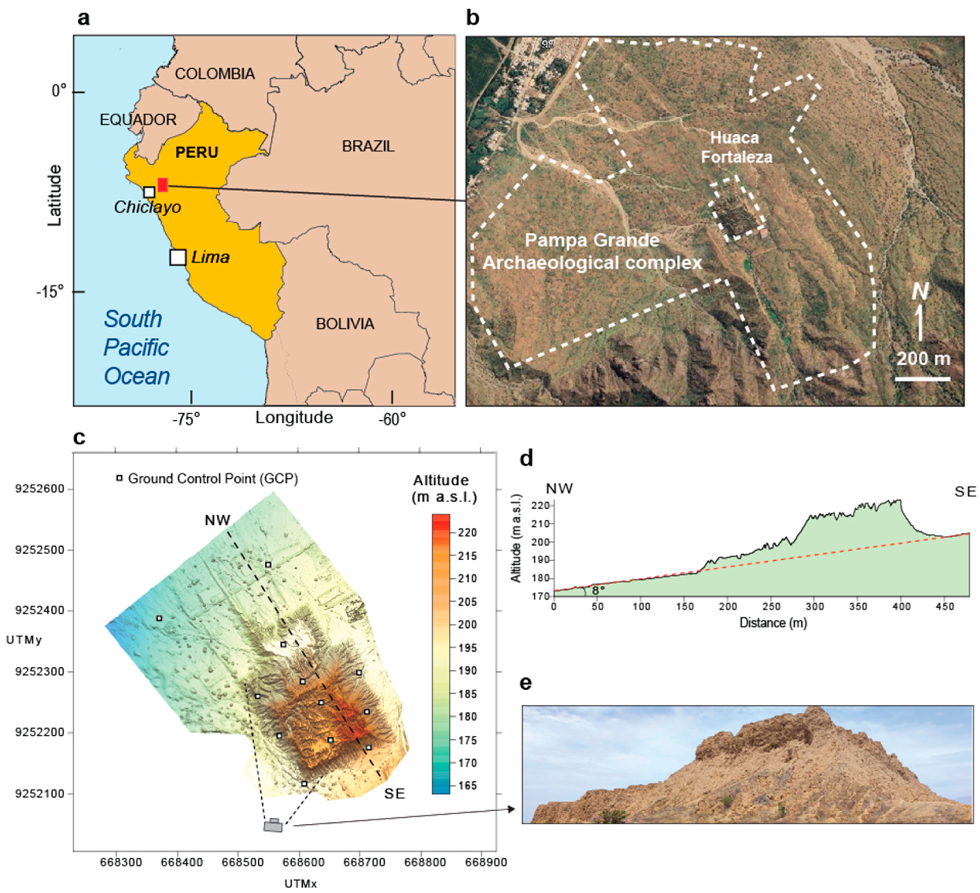
2. Archeological Setting of Pampa Grande Site and Huaca Fortaleza
3. Methods
3.1. Photogrammetric Survey and Digital Surface Model (DSM)
3.2. Morphometric Parameters
- -
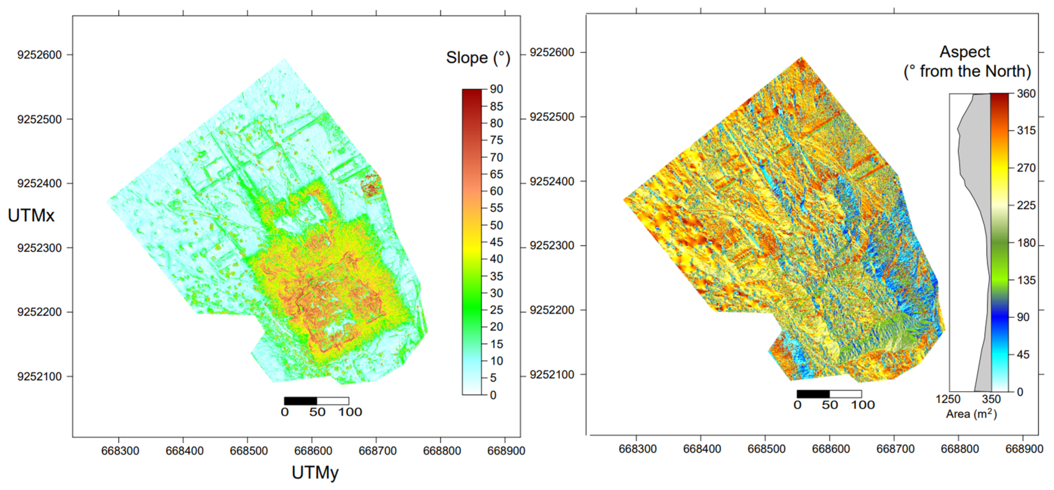
- Slope is measured in degrees and calculated according to [55]:
- -
- Aspect is the azimuth that a terrain surface faces. Aspect is measured in degrees from the north in a clockwise trend following [55]:
- -
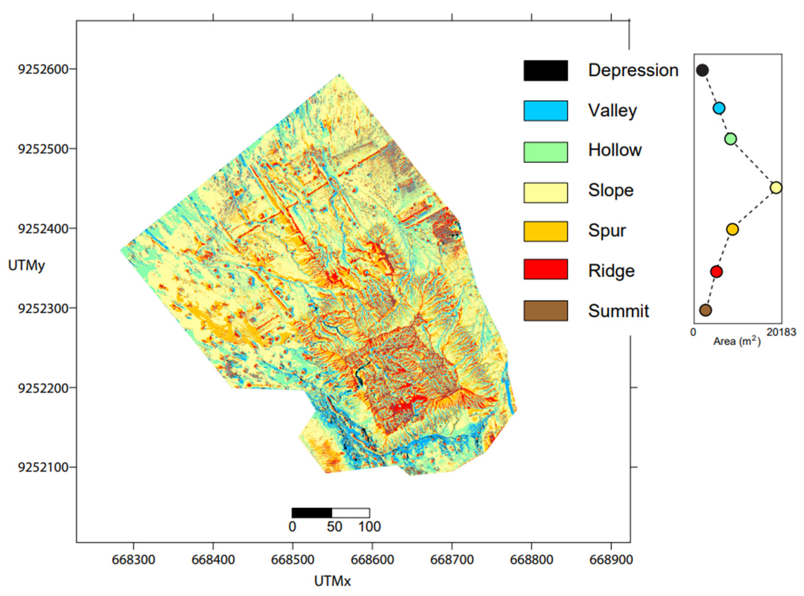
- Geomorphons. This parameter reflects a land-surface classification method identifying terrain forms by analyzing the spatial pattern of relative elevation differences around each point in a DSM [56]. Geomorphons are computed using a ternary pattern of line-of-sight comparisons between a central cell and a set of surrounding cells distributed along eight cardinal and intercardinal directions. For each direction, the relationship between the central cell and the outer cell is encoded as one of three states (higher, lower, or equal) producing a ternary pattern that is then matched to one of the following fundamental landform types: depression, summit, ridge, spur, slope, hollow, and valley.
- -
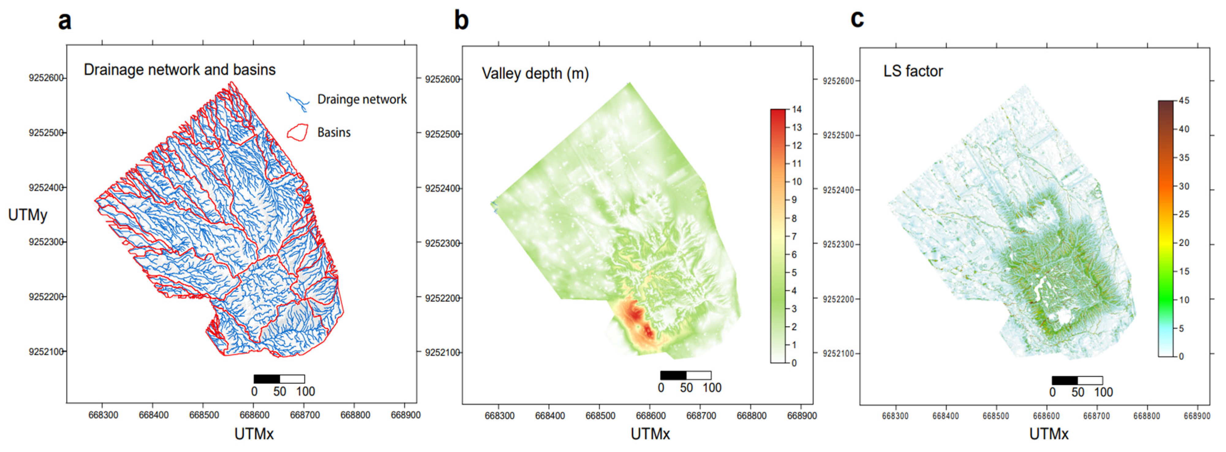
- Drainage network and watershed basins. The map of the stream network and watershed basins has been determined with the Deterministic 8 Neighbor algorithm [57,58,59] (https://saga-gis.sourceforge.io/en/index.html, (accessed on 20 March 2026)). The algorithm requires the DSM and the threshold for the Strahler order as data input. The threshold of Strahler is required to initiate the channel network and delimit the basins. We select a Strahler order of 5 and delete the streams with length < 10 m to obtain a sufficiently detailed network of the main streams by avoiding minor incisions.
- -
- Valley depth. This parameter is determined following [59] as specified at https://saga-gis.sourceforge.io/saga_tool_doc/6.1.0/ta_channels_7.html (accessed on 15 January 2026). Valley depth is determined as difference between the altitude and an interpolated ridge level. Ridge level interpolation uses an algorithm performing the following steps: (a) outlining ridges using Strahler order on an inverted DSM, (b) interpolation of the ridge levels, and subtraction of the original elevations from the ridge levels.
- -
- LS factor combines the following two components: the L factor, which represents the effect of slope length (i.e., the horizontal distance from the point of origin of overland flow to the point where either deposition begins or runoff enters a defined channel), and the S factor, which expresses the influence of slope gradient. Together, these two components capture the potential erosive power of water moving downslope. The underlying physical rationale of the LS factor is that longer and steeper slopes generate higher flow velocities and greater shear stress at the soil surface, thereby increasing the transport capacity of overland flow.
- -
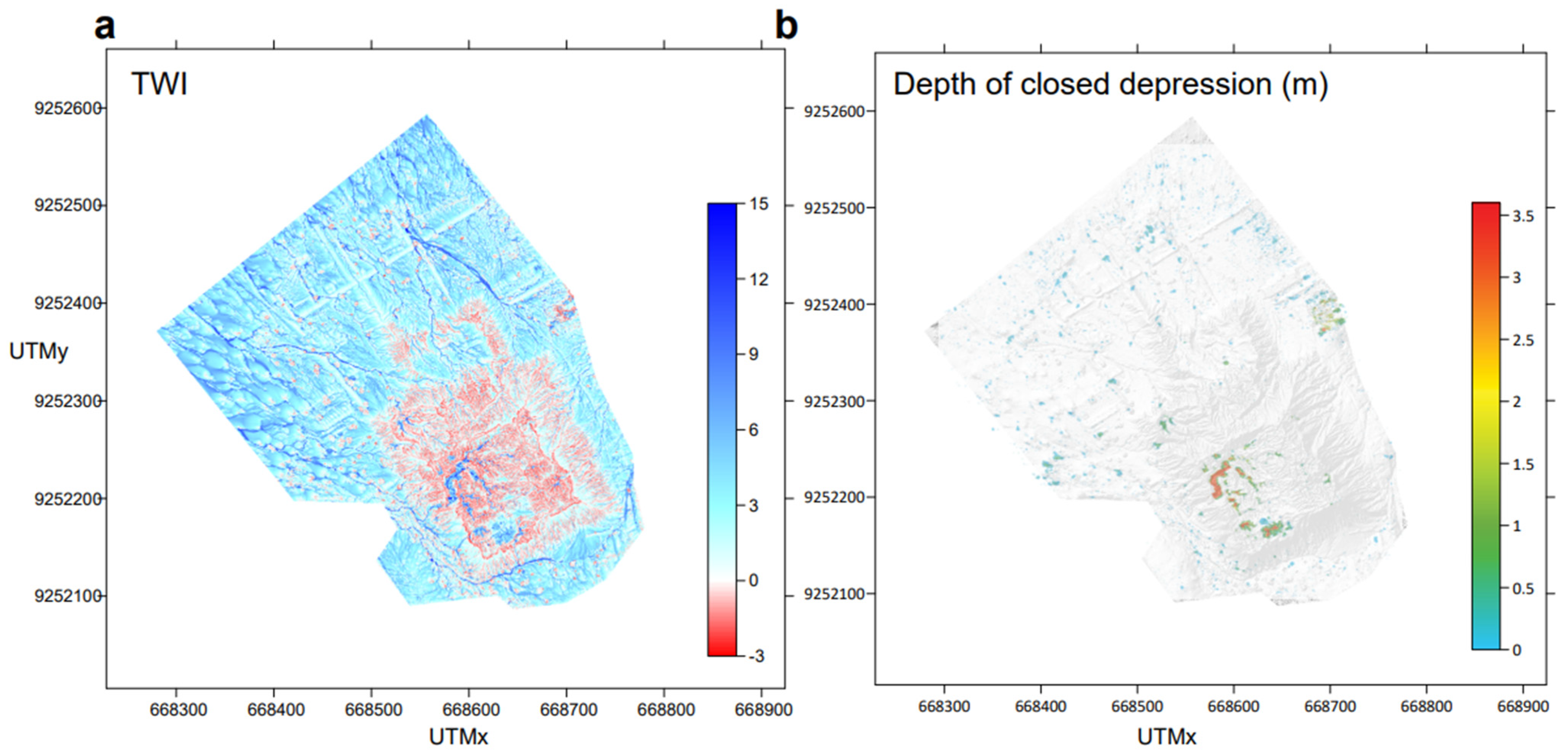
- Topographic Wetness Index (TWI) defines the areas characterized by water flow or stagnation during rain episodes [63]. TWI is a dimensionless parameter defining the balance of catchment water supply and local drainage. TWI calculation requires the following two input parameters [64]: the local upslope area draining through a certain point per unit contour length A, and the local slope S in radians. The analytical expression is:
- -
- Closed depressions define the zones where the water may stagnate, i.e., the zones surrounded by higher terrains in all directions. We use the algorithm by [57], which has been validated by [65]. The digital map of the depth of then closed depressions is obtained by subtracting the depression-free DSM from the original DSM.
- -
4. Results
5. Discussion
6. Conclusions
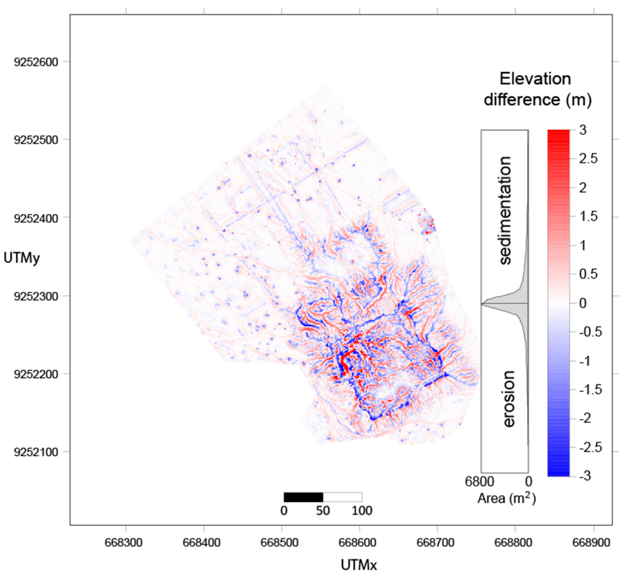
- Erosion is the dominant geomorphic process affecting HF, with the structure exhibiting significantly higher erosion intensity than the surrounding plain, as indicated by the geomorphological features, elevated LS factor and predominantly negative TWI values across the HF flanks and top.
- The flanks are dissected by a well-developed network of parallel rills and gullies, with incision depths reaching up to 8 m demonstrating that erosion has penetrated deeply into the adobe fabric of truncated pyramid. Rills are attributed to low-intensity diffusive rainfall processes, whereas gullies formed during high-intensity ENSO precipitation events occurring seasonally between February and May. Asymmetric morphological degradation among the HF flanks is partly explained by wind-controlled rainfall directionality associated with ENSO.
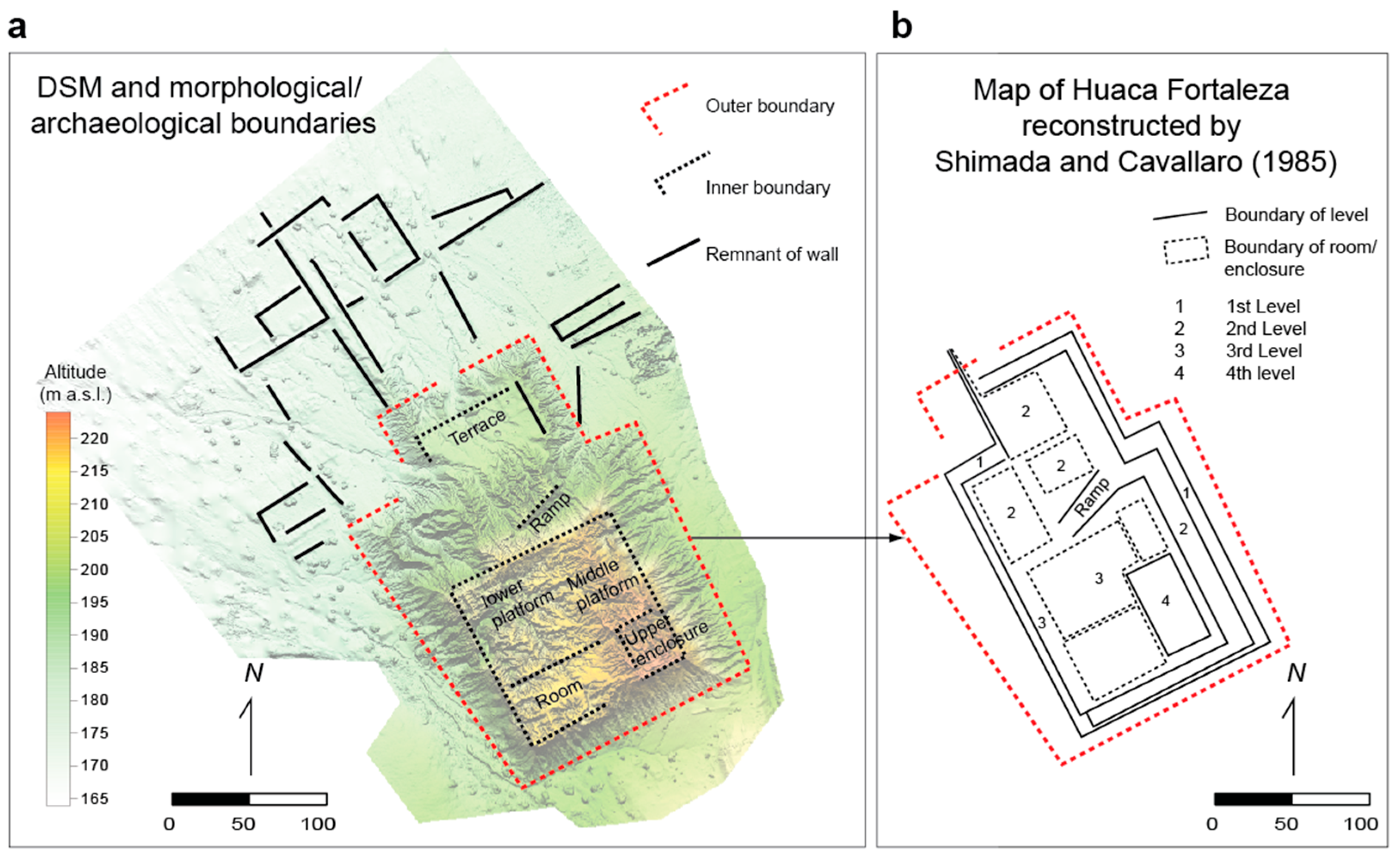
- Architectural discontinuities such as wall boundaries and former access ramps act as preferential pathways for concentrated flow, accelerating localized erosion. The SW-facing flank represents the most critical sector of the HF building, where deep incision is compounded by gravitational instability. Localized water ponding within closed depressions on the upper platform poses an additional long-term risk through downward infiltration and internal dissolution of adobe materials. The cumulative effect of erosion processes has caused extensive architectural loss, with the platforms of levels 1 and 2 now entirely obliterated and only portions of the upper levels remaining recognizable.
- Average vertical erosion rates are estimated at 0.28–0.38 m/century, comparable to fluvial incision rates documented in natural river systems over similar timescales. Erosion due to diffusion processes is roughly estimated in 0.015 m/century. The net volumetric balance between erosion and deposition indicates internal mass redistribution rather than net export. Diffusion processes are expected to progressively smooth the surface and remove architectural detail.
Supplementary Materials
Author Contributions
Funding
Institutional Review Board Statement
Informed Consent Statement
Data Availability Statement
Acknowledgments
Conflicts of Interest
References
- Agapiou, A.; Lysandrou, V.; Hadjimitsis, D.G. A European-scale investigation of soil erosion threat to subsurface archaeological remains. Remote Sens. 2020, 12, 675. [Google Scholar] [CrossRef]
- Borrelli, P.; Robinson, D.A.; Panagos, P.; Lugato, E.; Yang, J.E.; Alewell, C.; Wuepper, D.; Montanarella, L.; Ballabio, C. Land use and climate change impacts on global soil erosion by water (2015–2070). Proc. Natl. Acad. Sci. USA 2020, 117, 21994–22001. [Google Scholar] [CrossRef] [PubMed]
- Emberson, R.A. Dynamic rainfall erosivity estimates derived from IMERG data. Hydrol. Earth Syst. Sci. 2023, 27, 3547–3563. [Google Scholar] [CrossRef]
- Panagos, P.; Borrelli, P.; Meusburger, K.; Yu, B.; Klik, A.; Jae Lim, K.; Yang, J.E.; Ni, J.; Miao, C.; Chattopadhyay, N.; et al. Global rainfall erosivity assessment based on high-temporal resolution rainfall records. Sci. Rep. 2017, 7, 4175. [Google Scholar] [CrossRef] [PubMed]
- Adeyeri, O.E.; Folorunsho, A.H.; Adeliyi, T.E.; Ayegbusi, K.I.; Akinsanola, A.A.; Ndehedehe, C.E.; Ahmed, N.; Babalola, T.E. Climate change is intensifying rainfall erosivity and soil erosion in West Africa. Sci. Total Environ. 2024, 955, 177174. [Google Scholar] [CrossRef] [PubMed]
- Harkin, D.; Davies, M.; Hyslop, E.; Fluck, H.; Wiggins, M.; Merritt, O.; Barker, L.; Deery, M.; McNeary, R.; Westley, K. Impacts of climate change on cultural heritage. MCCIP Sci. Rev. 2020, 16, 24–39. [Google Scholar]
- Sesana, E.; Gagnon, A.S.; Ciantelli, C.; Cassar, J.; Hughes, J.J. Climate change impacts on cultural heritage: A literature review. WIREs Clim. Change 2021, 12, e710. [Google Scholar] [CrossRef]
- Orr, S.A.; Young, M.; Stelfox, D.; Curran, J.; Viles, H. Wind-driven rain and future risk to built heritage in the United Kingdom: Novel metrics for characterising rain spells. Sci. Total Environ. 2018, 640, 1098–1111. [Google Scholar] [CrossRef] [PubMed]
- Daly, C.; Purcell, C.E.; Donnelly, J.; Chan, C.; MacDonagh, M.; Cox, P. Climate change adaptation planning for cultural heritage, a national scale methodology. J. Cult. Herit. Manag. Sustain. Dev. 2021, 11, 313–329. [Google Scholar]
- Kapsomenakis, J.; Douvis, C.; Poupkou, A.; Zerefos, S.; Solomos, S.; Stavraka, T.; Melis, N.S.; Kyriakidis, E.; Kremlis, G.; Zerefos, C. Climate change threats to cultural and natural heritage UNESCO sites in the Mediterranean. Environ. Dev. Sustain. 2022, 25, 14519–14544. [Google Scholar] [CrossRef]
- Vandemeulebroucke, I.; Kotova, L.; Caluwaerts, S.; van Den Bossche, N. Degradation of brick masonry walls in Europe and the Mediterranean: Advantages of a response-based analysis to study climate change. Build. Environ. 2023, 230, 109963. [Google Scholar]
- Gandreau, D.; Delboy, L. World Heritage: Inventory of Earthen Architecture; CRATerre-ENSAG: Grenoble, France, 2012; pp. 1–284. [Google Scholar]
- Jiménez Rios, A.; Ruiz-Capel, S.; Plevris, V.; Nogal, M. Computational methods applied to earthen historical structures. Front. Built Environ. 2023, 9, 1219108. [Google Scholar] [CrossRef]
- Sharma, V.; Marwaha, B.M.; Vinayak, H.K. Enhancing durability of adobe by natural reinforcement for propagating sustainable mud housing. Int. J. Sustain. Built Environ. 2016, 5, 141–155. [Google Scholar] [CrossRef]
- Cieza de León, P. Crónica del Perú; Sevilla, 1553. Available online: https://fuenteshistoricasdelperu.com/2023/04/07/cronica-del-peru-por-pedro-cieza-de-leon-sevilla-1553/ (accessed on 30 June 2025).
- Donnan, C. En busca de Naylamp: Chotuna, Chornancap y el valle de Lambayeque. In Lambayeque; De Lavalle, J.A., Ed.; Banco de Crédito del Perú: Lima, Peru, 1989; pp. 105–136. [Google Scholar]
- Ortloff, C.R.; Kolata, A.L. El Niño and the ancient civilizations of Peru. Geoarchaeology 1993, 8, 415–428. [Google Scholar]
- Yeh, S.-W.; Kug, J.-S.; Dewitte, B.; Kwon, M.-O.; Kirtman, B.P.; Jin, F.-F. El Niño in a changing climate. Nature 2009, 461, 511–514. [Google Scholar] [CrossRef] [PubMed]
- Magnini, L.; Pozzi-Escot, D.; Oshiro, J.; Angeles, R.; Pannaccione Apa, M.I.; Ventura, G. Effects of the architectural layout of the Sanctuary of Pachacamac (2nd–16th century CE, Peru) on the exposure to rain, wind, and solar radiation from the morphometric analysis of digital surface models. Remote Sens. 2024, 16, 1848. [Google Scholar] [CrossRef]
- Sandweiss, D.H.; Maasch, K.A.; Richardson, J.B.; Rollins, H.B.; Clement, A. Variation in Holocene El Niño frequencies: Climate records and cultural consequences in ancient Peru. Geology 2001, 29, 603–606. [Google Scholar] [CrossRef]
- Moseley, M.E. El Niño and the collapse of the Moche civilization. In El Niño and the Southern Oscillation: Multiscale Variability and Global and Regional Impacts; Diaz, H.F., Markgraf, V., Eds.; Cambridge University Press: Cambridge, UK, 2001; pp. 461–481. [Google Scholar]
- Kanner, L.C.; Burns, S.J.; Cheng, H.; Edwards, R.L.; Vuille, M. High-resolution variability of the South American summer monsoon over the last seven millennia: Insights from a speleothem record from the central Peruvian Andes. Quat. Sci. Rev. 2013, 75, 1–10. [Google Scholar] [CrossRef]
- Romero, R.; Takahashi, K.; Espinoza, J.C.; Lavado-Casimiro, W.; Sulca, J.; Carbajal, L. Flood hazards and impacts in the Peruvian coastal region during El Niño episodes. Nat. Hazards Earth Syst. Sci. 2009, 9, 81–94. [Google Scholar]
- García, A.; Takahashi, K.; Espinoza, J.C.; Lavado-Casimiro, W.; Sulca, J.; Carbajal, L. Socioeconomic impacts of El Niño in northern Peru: Historical and modern perspectives. J. Lat. Am. Geogr. 2012, 11, 123–144. [Google Scholar]
- Peng, Q.; Xie, S.-P.; Passalacqua, G.A.; Miyamoto, A.; Deseret, C. The 2023 extreme coastal El Niño: Atmospheric and air-sea coupling mechanisms. Sci. Adv. 2024, 10, eadk8646. [Google Scholar] [CrossRef] [PubMed]
- Vieira, M.T.; Vieira, A.V.; García, C.M.V. Vulnerability index elaboration for climate change adaptation in Peru. Eur. J. Sustain. Dev. 2019, 8, 102–114. [Google Scholar] [CrossRef]
- L’Heureux, M.L.; Tippett, M.K.; Takahashi, K.; Barnston, A.G.; Becker, E.J.; Bell, G.D.; Di Liberto, T.E.; Gottschalck, J.; Halpert, M.S.; Hu, Z.-Z.; et al. Strength outlooks for the El Niño-Southern Oscillation. Weather Forecast. 2019, 34, 165–175. [Google Scholar] [CrossRef]
- Alexopoulos, M.J.; Iliopoulou, T.; Modé, P.; Istrati, D.; Spyrakos, C.C.; Soile, S.; Verykokou, S.; Ioannidis, C.; Koutsoyiannis, D. A novel and scalable flood risk assessment framework for cultural heritage based on unmanned aerial vehicle photogrammetry and multi-scale rain-on-grid hydraulic modeling. Sci. Total Environ. 2025, 998, 180256. [Google Scholar] [CrossRef] [PubMed]
- Shimada, I. Pampa Grande and the Mochica Culture; University of Texas Press: Austin, TX, USA, 1994. [Google Scholar]
- Selby, M.J. Hillslope Materials and Processes, 2nd ed.; Oxford University Press: New York, NY, USA, 1993; 446p. [Google Scholar]
- Pelletier, J.D. Quantitative Modeling of Earth Surface Processes; Cambridge University Press: Cambridge, UK, 2008; 295p. [Google Scholar]
- Bui, Q.B.; Morel, J.C.; Reddy, B.V.V.; Ghayad, W. Durability of rammed earth walls exposed for 20 years to natural weathering. Build. Environ. 2009, 44, 912–919. [Google Scholar] [CrossRef]
- Wang, X.D.; Zhang, H.Y.; Yan, G.S.; Pei, Q.Q. Durability of ancient earthen architecture under wind erosion in the Milan ancient city along the Silk Road of China. Adv. Mater. Res. 2011, 163–167, 3230–3236. [Google Scholar]
- Campiani, A.; Lingle, A.; Lercari, N. Spatial analysis and heritage conservation: Leveraging 3-D data and GIS for monitoring earthen architecture. J. Cult. Herit. 2019, 39, 166–176. [Google Scholar] [CrossRef]
- Richards, J.; Zhao, G.; Zhang, H.; Vile, H. A controlled field experiment to investigate the deterioration of earthen heritage by wind and rain. Herit. Sci. 2019, 7, 51. [Google Scholar] [CrossRef]
- UNESCO. Climate Change and World Heritage; UNESCO World Heritage Centre: Paris, France, 2007. [Google Scholar]
- Sabbioni, C.; Brimblecombe, P.; Cassar, M. The Atlas of Climate Change Impact on European Cultural Heritage: Scientific Analysis and Management Strategies; Anthem Press: London, UK, 2010. [Google Scholar]
- Xiao, W.; Mills, J.; Guidi, G.; Rodríguez-Gonzálvez, P.; Gonizzi Barsanti, S.; González-Aguilera, D. Geoinformatics for the conservation and promotion of cultural heritage in support of the UN sustainable development goals. ISPRS J. Photogramm. Remote Sens. 2018, 142, 389–406. [Google Scholar] [CrossRef]
- Shimada, I. Cultura Sicán: Dios, Riqueza y Poder en la Costa Norte del Perú; Fundación del Banco Continental para el Fomento de la Educación y la Cultura: Lima, Peru, 1995; pp. 1–226. [Google Scholar]
- Sandweiss, D.H.; Maasch, K.A. Climatic and Cultural Transitions in Lambayeque, Peru, 600 to 1540 AD: Medieval Warm Period to the Spanish Conquest. Geosciences 2022, 12, 238. [Google Scholar] [CrossRef]
- Shimada, I.; Schaaf, C.B.; Thompson, L.G.; Mosley-Thompson, E. Cultural impacts of severe droughts in the prehistoric Andes. World Archaeol. 1991, 22, 247–270. [Google Scholar] [CrossRef]
- Bawden, G. The structural paradox: Moche culture as political ideology. Lat. Am. Antiq. 1996, 6, 255–273. [Google Scholar]
- Moseley, M.E. The Incas and Their Ancestors; Thames and Hudson: London, UK, 1992. [Google Scholar]
- Wilson, D. Early State Formation on the Peruvian North Coast: A Critique of the ‘City-State’. In The Archaeology of City-States (Smithsonian Series on Archaeological Inquiry); Smithsonian Institution Press: Washington, DC, USA, 1997. [Google Scholar]
- Chapdelaine, C. (Moche and Wari during the Middle Horizon on the north coast of Peru. In Beyond Wari Walls: Exploring the Nature of Middle Horizon Peru away from Wari Centers; University of New Mexico Press: Albuquerque, NM, USA, 2010. [Google Scholar]
- Chapdelaine, C. Recent advances in Moche archaeology. J. Archaeol. Res. 2011, 18, 191–227. [Google Scholar]
- Shimada, I.; Cavallaro, R. Monumental adobe architecture of the late prehispanic northern north coast of Peru. J. Soc. Am. 1985, 71, 41–78. [Google Scholar] [CrossRef]
- Castillo, L.J.; Donnan, C.B. Los Mochicas del Norte y los Mochicas del Sur. In Vicús; Banco de Crédito del Perú: Lima, Peru, 1994; pp. 143–181. [Google Scholar]
- Magnini, L.; Pannaccione Apa, M.I.; Gutierrez, R.F.; Manayalle, M.-F.; Wester La Torre, C.E.; Ventura, G. Effects of rain and sediment-laden winds on earthen archaeological sites from morphometry: A case study from Huaca Chotuna (8th–16th century AD), Lambayeque, Peru. Remote Sens. 2025, 17, 3103. [Google Scholar] [CrossRef]
- Pannaccione Apa, M.I.; La Torre, C.W.; Gutierrez Cachay, R.F.; Magnini, L.; Murga, J.C.; Ranera, F.; Ventura, G. Quantitative estimate of the damages from human activities at the Apurlec monumental archaeological complex (seventh–fourteenth century AD, Peru) from multitemporal photogrammetry. Archaeol. Anthropol. Sci. 2023, 15, 110. [Google Scholar] [CrossRef]
- Adamopoulos, E.; Rinaudo, F. UAS-based archaeological remote sensing: Review, meta-analysis and state-of-the-art. Drones 2020, 4, 46. [Google Scholar] [CrossRef]
- Hengl, T.; Reuter, H.I. Geomorphometry: Concepts, Software, Applications; Elsevier Science: Amsterdam, The Netherlands, 2009; pp. 1–765. [Google Scholar]
- Fernandes, N.F.; Dietrich, W.E. Hillslope evolution by diffusive processes: The timescale for equilibrium adjustments. Water Resour. Res. 1997, 33, 1307–1318. [Google Scholar] [CrossRef]
- Martin, Y. Modelling hillslope evolution: Linear and nonlinear transport relations. Geomorphology 2000, 34, 1–21. [Google Scholar] [CrossRef]
- Moore, I.D.; Lewis, A.; Gallant, J.C. Terrain properties: Estimation methods and scale effects. In Modeling Change in Environmental Systems; Jakeman, A.J., Ed.; John Wiley & Sons: New York, NY, USA, 1993. [Google Scholar]
- Jasiewicz, J.; Stepinski, T.F. Geomorphons—A pattern recognition approach to classification and mapping of landforms. Geomorphology 2013, 182, 147–156. [Google Scholar] [CrossRef]
- Wang, L.; Liu, H. An efficient method for identifying and filling surface depressions in digital elevation models for hydrologic analysis and modelling. Int. J. Geogr. Inf. Sci. 2006, 20, 193–213. [Google Scholar] [CrossRef]
- Zhao, G.J.; Gao, J.F.; Tian, P.; Tian, K. Comparison of two different methods for determining flow direction in catchment hydrological modeling. Water Sci. Eng. 2009, 2, 1–15. [Google Scholar]
- Conrad, O.; Bechtel, B.; Bock, M.; Dietrich, H.; Fischer, E.; Gerlitz, L.; Wehberg, J.; Wichmann, V.; Böhner, J. System for automated geoscientific analyses (SAGA) v. 2.1.4. Geosci. Model Dev. 2015, 8, 1991–2007. [Google Scholar] [CrossRef]
- Moore, I.D.; Burch, G.J. Physical basis of the length-slope factor in the Universal Soil Loss Equation. Soil Sci. Soc. Am. J. 1986, 50, 1294–1298. [Google Scholar] [CrossRef]
- Desmet, P.J.J.; Govers, G. A GIS procedure for automatically calculating the USLE LS factor on topographically complex landscape units. J. Soil Water Conserv. 1996, 51, 427–433. [Google Scholar] [CrossRef]
- Howland, M.D.; Jones, I.W.N.; Najjar, M.; Levy, T.E. Quantifying the effects of erosion on archaeological sites with low-altitude aerial photography, structure from motion, and GIS: A case study from southern Jordan. J. Archaeol. Sci. 2018, 90, 62–70. [Google Scholar] [CrossRef]
- Beven, K.J.; Kirkby, M.J. A physically based, variable contributing area model of basin hydrology. Hydrol. Sci. Bull. 1979, 24, 43–69. [Google Scholar] [CrossRef]
- Kopecký, M.; Macek, M.; Wild, J. Topographic wetness index calculation guidelines based on measured soil moisture and plant species composition. Sci. Total Environ. 2021, 757, 143785. [Google Scholar] [CrossRef] [PubMed]
- Pardo-Igúzquiza, E.; Dowd, P.A. The mapping of closed depressions and its contribution to the geodiversity inventory. Int. J. Geoherit. Parks 2021, 9, 480–495. [Google Scholar] [CrossRef]
- McKean, J.A.; Dietrich, W.E.; Finkel, R.C.; Southon, J.R.; Caffee, M.W. Quantification of soil production and downslope creep rates from cosmogenic 10Be accumulations on a hillslope profile. Geology 1993, 21, 343–346. [Google Scholar] [CrossRef]
- Shi, H.; Xiao, H.; Liu, G.; Abd Elbasit, M.A.; Zheng, F.; Zhang, Q.; Zhang, Y.; Guo, Z. Identifying interrill, rill, and ephemeral gully erosion evolution by using rare earth elements as tracers. J. Hydrol. 2022, 612, 128271. [Google Scholar] [CrossRef]
- Nativ, R.; Turowski, J.M. Site dependence of fluvial incision rate scaling with timescale. J. Geophys. Res. Earth Surf. 2020, 125, e2020JF005808. [Google Scholar] [CrossRef]




Disclaimer/Publisher’s Note: The statements, opinions and data contained in all publications are solely those of the individual author(s) and contributor(s) and not of MDPI and/or the editor(s). MDPI and/or the editor(s) disclaim responsibility for any injury to people or property resulting from any ideas, methods, instructions or products referred to in the content. |
© 2026 by the authors. Licensee MDPI, Basel, Switzerland. This article is an open access article distributed under the terms and conditions of the Creative Commons Attribution (CC BY) license.
Share and Cite
Magnini, L.; Apa, M.I.P.; Gutiérrez Cachay, R.F.; Del Gaudio, P.; La Torre, C.E.W.; Ventura, G. Erosion Assessment at Earthen Archeological Sites by Morphometric Analysis of Digital Surface Models: The Case of Huaca Fortaleza (Pampa Grande, Peru, 600–750 AD). Appl. Sci. 2026, 16, 6610. https://doi.org/10.3390/app16136610
Magnini L, Apa MIP, Gutiérrez Cachay RF, Del Gaudio P, La Torre CEW, Ventura G. Erosion Assessment at Earthen Archeological Sites by Morphometric Analysis of Digital Surface Models: The Case of Huaca Fortaleza (Pampa Grande, Peru, 600–750 AD). Applied Sciences. 2026; 16(13):6610. https://doi.org/10.3390/app16136610
Chicago/Turabian StyleMagnini, Luigi, Maria Ilaria Pannaccione Apa, Robert F. Gutiérrez Cachay, Pierdomenico Del Gaudio, Carlos Eduardo Wester La Torre, and Guido Ventura. 2026. "Erosion Assessment at Earthen Archeological Sites by Morphometric Analysis of Digital Surface Models: The Case of Huaca Fortaleza (Pampa Grande, Peru, 600–750 AD)" Applied Sciences 16, no. 13: 6610. https://doi.org/10.3390/app16136610
APA StyleMagnini, L., Apa, M. I. P., Gutiérrez Cachay, R. F., Del Gaudio, P., La Torre, C. E. W., & Ventura, G. (2026). Erosion Assessment at Earthen Archeological Sites by Morphometric Analysis of Digital Surface Models: The Case of Huaca Fortaleza (Pampa Grande, Peru, 600–750 AD). Applied Sciences, 16(13), 6610. https://doi.org/10.3390/app16136610