1. Introduction
Unmanned Aerial Vehicles (UAVs) have been widely deployed in tasks such as mapping, remote sensing, inspection, emergency search and rescue, and low-altitude autonomous navigation [
1] because of their high maneuverability and low deployment costs [
2]. In UAV applications, acquiring accurate depth information is of paramount importance. Recently, with the advancement of deep learning, depth estimation methods that extract depth information from UAV imagery have shown great advantages over traditional depth sensor solutions in lightweight applications. However, these techniques struggle significantly when adapted to oblique viewpoints in UAV imagery. First, such approaches rely heavily on large-scale, high-quality depth-labeled data [
3]. In UAV scenarios, obtaining precise ground-truth depth at scale is nearly impractical due to high acquisition costs, hardware constraints, and environmental complexity. Furthermore, the domain discrepancy between terrestrial training samples and aerial UAV perspectives often hinders performance. This is particularly evident when the camera tilt exceeds 45 degrees, where severe perspective warping and featureless regions typically trigger major depth estimation inaccuracies in vital areas. These restrictions make it difficult to apply these methods to large real-world scenarios that lack dense annotations.
Self-supervised monocular depth estimation has gained considerable traction recently, offering a promising solution to reduce the heavy dependency on densely annotated depth data [
4]. This approach reformulates depth learning as a view-synthesis problem. By jointly training a DepthNet and a PoseNet [
5], it utilizes predicted depth and camera ego-motion to reproject adjacent frames onto a target frame, and optimizes the network by minimizing the photometric reprojection error. In the field of autonomous driving, Zhou et al. [
6] first utilized view-synthesis loss for self-supervision. A minimum reprojection loss and an automatic masking scheme were proposed by Godard et al. [
7] to mitigate the adverse effects of moving objects and occluded regions. Subsequently, Godard et al. [
7] established itself as a key baseline by significantly improving robustness through a multi-scale, full-resolution sampling strategy. By integrating Convolutional Neural Networks with Transformers, Lite-Mono [
8] drastically reduced model parameters by 80% through a lightweight design. Meanwhile, MonoViT [
9] embedded Vision Transformers into its pipeline to better capture both global contexts and local fine-grained details.
While these architectures perform exceptionally well in ground-based autonomous navigation, applying them straightforwardly to UAV imagery is still highly problematic. UAV viewpoints typically involve large pitch and roll variations, which are accompanied by rapid altitude changes, intense perspective distortions, and significant scale fluctuations. Furthermore, aerial images often contain expansive weakly textured regions such as rooftops, water surfaces, and vegetation. These images also suffer from photometric inconsistencies caused by lighting changes, reflections, and atmospheric scattering. Under these conditions, self-supervised constraints based on photometric consistency become unstable, leading to issues such as depth blurring, indistinct boundaries, and structural distortion.
In response to these issues, recent studies have begun exploring depth estimation methods specifically tailored for UAV scenarios. Hermann et al. [
10] constructed a new architecture for UAV scenes based on Monodepth2. To capture the temporal dynamics inherent in drone footage, Madhuanand et al. [
11] presented a self-supervised pipeline featuring a dual-encoder setup alongside a 3D CNN decoder. Yu et al. [
12] proposed a depth optimization method combining multi-scale feature fusion and edge constraints to address depth continuity in low-altitude scenes. These studies demonstrate that incorporating UAV-specific characteristics into model design is crucial for enhancing performance.
Based on the aforementioned analysis, this paper adopts Lite-Mono [
8] as the baseline and proposes a lightweight self-supervised monocular depth estimation (MDE) framework for UAV viewpoints. In this study, we aim to tackle the specific challenges of depth inference in oblique UAV images, thereby improving the overall accuracy of the predictions.
The main contributions of this work are as follows:
We integrate a custom-designed Dynamic Direction-Aware Module (DDaM) into the encoder stage of DepthNet. By learning global context to predict affine transformation parameters, the module dynamically adjusts the spatial sampling grid to perform geometric correction of low-level features.
We introduce a Coordinate Attention Mechanism [
13]. By decomposing spatial pooling into two one-dimensional direction-aware feature encodings along the horizontal and vertical axes, the network’s ability to represent spatial positional information is enhanced, which improves structural perception in weakly textured regions.
We conduct experiments on the MidAir synthetic dataset and the UAVid real-world dataset. The results demonstrate that our method achieves promising performance while maintaining a minimal parameter count. Furthermore, our experiments reveal that the synergy between the Dynamic Direction-Aware Module (DDaM) and the Coordinate Attention Mechanism further enhances the model’s prediction accuracy.
2. Related Work
Depth estimation plays a critical role in comprehending 3D spaces and enabling autonomous driving. Traditional depth sensing methods rely primarily on active sensors or multi-view geometry techniques such as LiDAR [
14], stereo matching [
15], and Structure from Motion (SfM) [
16]. Although these methods can recover accurate 3D scene structures, they are difficult to deploy on UAV platforms that are limited by weight and power consumption. By inferring dense depth maps directly from individual RGB frames, deep learning driven monocular approaches provide a highly efficient alternative for depth perception. Early supervised methods, such as the work by Eigen et al. [
17], showed that multi-scale convolutional networks can simultaneously capture global scene structures and local details. To mutually encode global and local spatial dependencies, Liu et al. [
18] integrated continuous Conditional Random Fields (CRFs) into the convolutional framework. Additionally, Fu et al. [
19] approached the task from a different perspective by casting depth prediction as an ordinal regression challenge, significantly improving accuracy through spacing-increasing discretization and ordinal regression. With the rise of Vision Transformers, AdaBins proposed by Bhat et al. [
20] and its derivative ZoeDepth [
21] reached new heights in the accuracy of supervised monocular metric depth estimation by combining relative depth with metric depth and introducing adaptive Bins.
2.1. Self-Supervised Monocular Depth Estimation
To eliminate the dependence on depth labels, self-supervised monocular depth estimation transforms the depth learning problem into a view reconstruction problem. Zhou et al. [
6] first formulated monocular depth estimation as a view-synthesis problem and enabled training on unlabeled monocular videos through the joint learning of depth and camera pose. Subsequently, Godard et al. [
22] further improved the accuracy and stability of unsupervised monocular depth estimation by utilizing stereo image pairs to introduce left-right consistency constraints. Mahjourian et al. [
23] introduced 3D geometric consistency constraints. Monodepth2 [
7] significantly improved the robustness of the model through minimum reprojection error and auto-masking, establishing itself as a benchmark in the field of monocular depth estimation. MonoViT [
9] successfully integrated Vision Transformers into the self-supervised framework, which greatly enhanced the global receptive field and the ability to capture fine details. Subsequently, DepthFormer [
24] utilized Transformers to reconstruct multi-frame feature matching and cost volume generation, thereby strengthening long-range dependencies.
2.2. Self-Supervised Monocular Depth Estimation for UAV Images
Compared to autonomous driving scenarios, UAV imagery features complex geometric and illumination characteristics, including oblique viewpoints, drastic variations in pitch and roll, and large areas of weakly textured regions. To handle the complex spatial structures of aerial perspectives, Miclea and Nedevschi [
25] modeled monocular depth estimation as classification and ordinal regression tasks to guide the network in learning pixel-level depth relationships. For this purpose, they trained their model on the MidAir [
26] synthetic dataset to obtain dense depth labels. Hermann et al. [
10] designed a self-supervised training strategy that utilizes shared encoder weights for both DepthNet and PoseNet. Madhuanand et al. [
11] employed twin 2D CNN encoders to extract features from adjacent frames, followed by a 3D CNN decoder to reconstruct the spatial depth information. Additionally, to refine the feature extraction process in low-altitude remote sensing data, Chang et al. [
27] designed a hybrid multi-scale network that enhances both local and global representations. Yu et al. [
12] proposed a scene-aware optimization network that addresses the issue of blurred depth predictions in weakly textured regions through multi-resolution feature fusion and edge enhancement modules. Their method achieved competitive results on the UAVid [
28] dataset. Existing studies have investigated the geometric adaptability of deep networks. Spatial Transformer Networks predict transformation parameters to improve robustness to spatial variations. Deformable Convolutional [
29] Networks further learn offsets for convolutional sampling locations, thereby enhancing the geometric modeling capability of CNNs. Kumar et al. [
30] modified the projection and back-projection functions for unrectified monocular videos. These methods show the effectiveness of adaptive spatial sampling for handling geometric changes.
Motivated by these observations, we focus on correcting geometric distortions in early-stage input features through scene-aware optimization. We design a Dynamic Direction-Aware Module (DDaM) and integrate it into the encoder of DepthNet. Specifically, the module uses two learnable directional parameters along the horizontal and vertical axes to strengthen direction-related cues, while rotation and shear parameters compensate for viewpoint-induced distortions in oblique aerial images. Before depth prediction, the transformed features are reprojected back to the coordinate space aligned with the original image, ensuring geometric consistency for self-supervised photometric reprojection. We further introduce Coordinate Attention at the end of the encoder to enhance long-range dependency modeling along the horizontal and vertical directions.
3. Methods
In this section, we propose a self-supervised depth estimation method optimized for oblique UAV imagery. The method consists of four subparts: the overall architecture, DepthNet, PoseNet, and the loss functions.
3.1. Overall Architecture
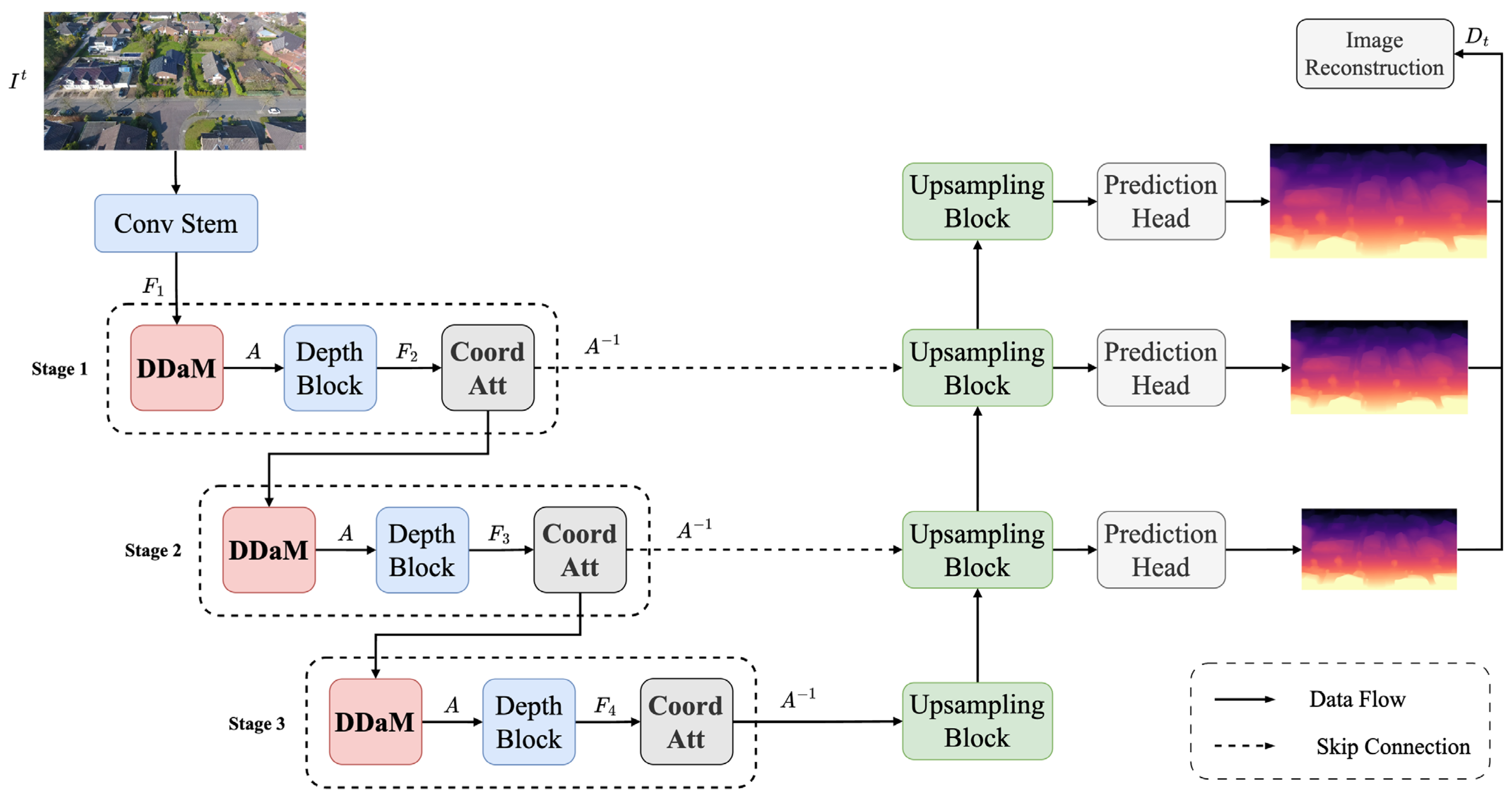
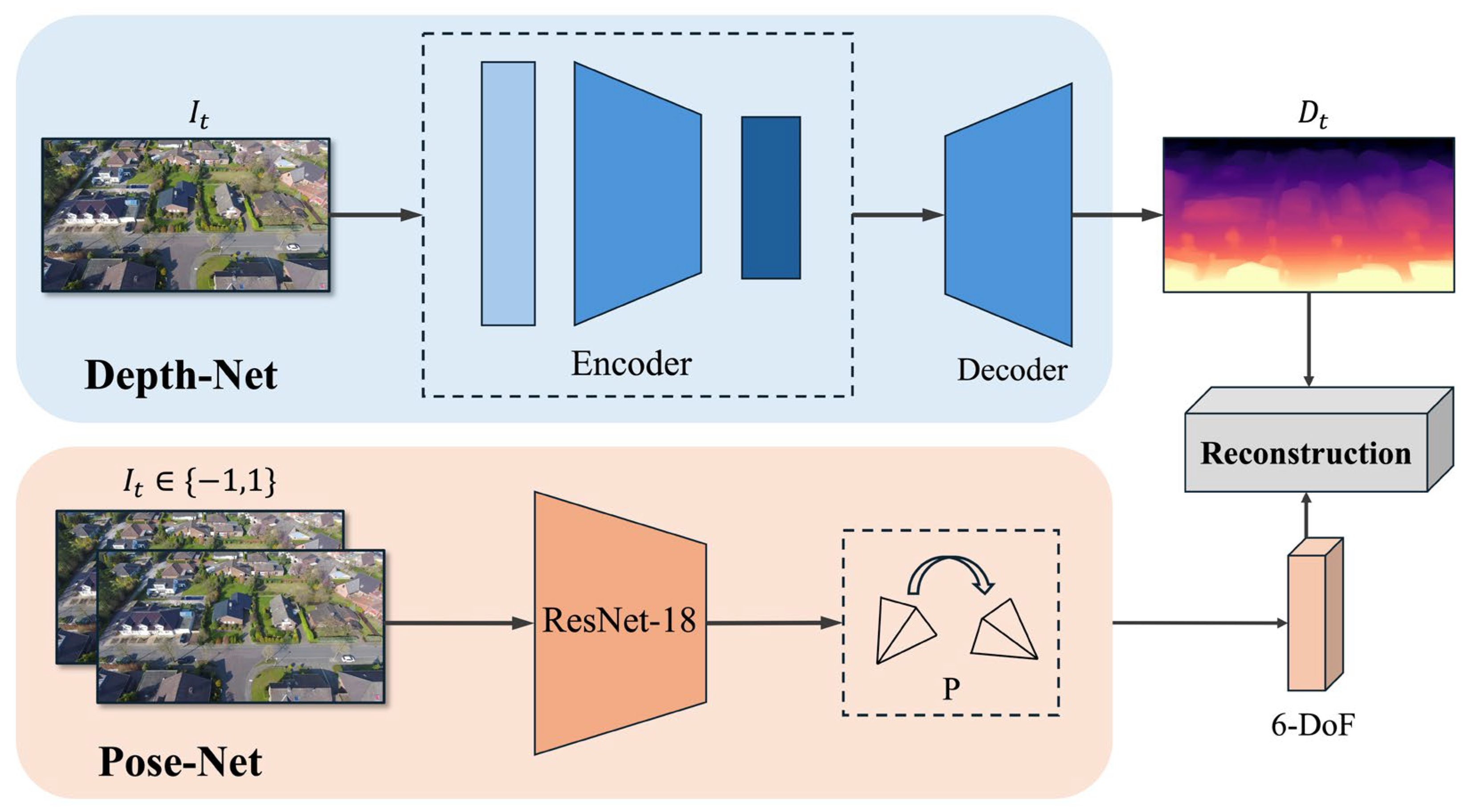
Our proposed framework is primarily composed of two fundamental modules: a DepthNet and a PoseNet. DepthNet computes multi-scale inverse depth maps from the input images, while PoseNet calculates the camera motion between adjacent frames. Both networks are jointly trained in a self-supervised manner. DepthNet employs an encoder–decoder structure. Within the encoder, the DepthBlock extracts rich hierarchical features by stacking the lightweight CDC blocks and the LGFI modules adopted from Lite-Mono. The proposed DDaM dynamically adjusts the receptive field of the convolution kernels to adaptively calibrate distorted features into a normalized canonical space. Coordinate Attention is integrated into the encoder, which decomposes spatial pooling into two direction-aware feature encodings along the horizontal and vertical axes. This process enhances the representation of spatial positional information within high-level semantic features. The decoder utilizes bilinear upsampling to output the depth map . This is formulated as , where represents the target frame. PoseNet takes the target frame and source frames as input to output camera motion between two adjacent frames that represent translation and rotation. This transformation is expressed by the formula , where . Subsequently, a synthesized target view is produced to formulate the objective loss for network optimization.
3.2. DepthNet
We adopt the same encoder–decoder architecture as the work in [
6,
7]. As illustrated in
Figure 1, the encoder is designed with four stages for feature extraction. The network first receives a single target frame
as input to extract shallow features. Specifically, the image is downsampled using a
convolution and is subsequently processed by two
convolutions with a
to generate a feature map of size
. In stage 1, features pass through the DDaM module, which utilizes a predicted affine transformation matrix for geometric correction to produce a feature map with a more uniform vertical distribution. Following this, a DepthBlock with a
convolution with a
outputs a feature map of size
. Stages 2 and 3 employ the same methodology to extract deep features, resulting in feature maps of size
and
. Furthermore, the outputs from Stage 1 and Stage 2 are fed into the decoder upsampling layers via skip connections to compensate for the spatial information that is typically lost during the upsampling process. Coordinate Attention is applied to encode positional information along two orthogonal directions before the upsampling stage, and back projection is performed to map the features back into the original coordinate space.
3.2.1. Dynamic Direction-Aware Module
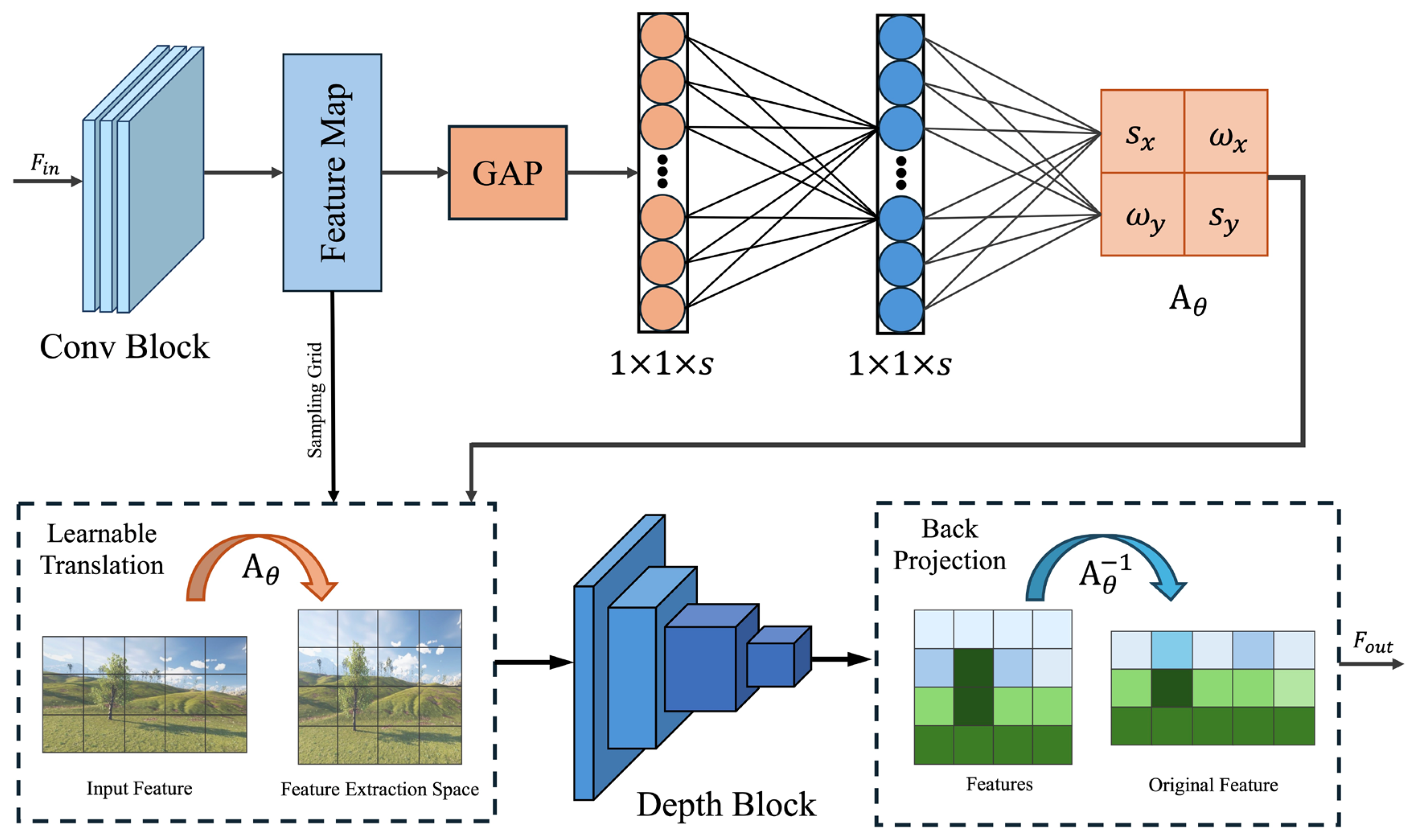
From a geometric perspective, the y-axis of oblique aerial images encodes highly compressed non-linear depth gradients, while the x-axis encodes contextual consistency among adjacent objects on the same focal plane. Standard CNNs employ a uniform receptive field across all spatial dimensions. This characteristic leads to blurred structural boundaries and severe geometric discontinuities. To overcome this problem, we propose the Dynamic Direction-Aware Module (DDaM), as shown in
Figure 2, which dynamically predicts an affine transformation
A based on the input. It balances sampling density and the receptive field by considering both local details and global dependencies. Furthermore, to ensure that the reprojection loss in self-supervised monocular depth estimation produces a dense depth map, the final output features undergo back-projection to the original space via
. This process can be expressed as Equation (1):
where
I represents the input features,
denotes the convolutional feature extraction block. In the proposed encoder, this operation is applied in a stage-wise manner. Specifically, DDaM is placed at the front end of the first three encoder stages, and each stage learns an independent affine transformation matrix.
In the initial stage, a preceding convolutional block generates a shallow feature map
F from the image. The DDaM first performs Global Average Pooling (GAP) across the 2D spatial dimensions of size
to produce a global feature
z. For the
c-th channel of
z, the operation is expressed in Equation (2) as:
Meanwhile, we utilize a Multi-Layer Perceptron (MLP) to compute the optimal affine transformation parameters under the current feature distribution. Specifically, the input layer of the MLP receives the vector
z with a feature dimension of
c. The MLP then outputs a vector containing learnable parameters, which is subsequently reshaped into the affine matrix
. These steps are expressed by Equations (3) and (4) as:
where
and
are the learnable weight matrices,
denotes the ReLU activation, and
r is the channel reduction ratio. With matrix
, rotation and shear are treated as two trainable parameters
and
, to compensate for the oblique perspective caused by UAV roll and pitch. Additionally, the scaling ratios are represented by two trainable parameters
and
, which dynamically adjust the sampling density and the receptive field. We apply sigmoid and tanh functions to provide constraints for
and
, respectively.
In the next stage, the predicted affine matrix
is applied to the original shallow feature map
to generate the geometrically rectified feature map
. For each pixel coordinate
in the target output feature map, its corresponding source coordinate
in the input feature map as Equation (5):
Finally, considering that the feature extraction space is not fully aligned with the original input space, we apply a backward projection transformation based on the inverse matrix before the output of each encoder stage is fed into the decoder, thereby projecting the feature maps back to the original space.
3.2.2. Coordinate Attention Mechanism
Coordinate Attention encodes long-range context separately along both the horizontal and vertical directions, embedding positional information into channel attention. This enables position-sensitive feature enhancement with low computational overhead. Traditional attention mechanisms utilize global average pooling to compress the spatial dimensions of feature maps into simple channel weights, which compromises the spatial positional information of the features. For UAV monocular depth estimation, Coordinate Attention is more suitable for addressing depth blurring issues caused by low-texture regions and rapid scale variations, both of which are common in low-altitude oblique scenarios. Specifically, we incorporate Coordinate Attention into the encoder. Given an intermediate deep feature map
, Coordinate Attention utilizes two one-dimensional average pooling kernels of sizes
and
to encode the vertical and horizontal spatial coordinates, as expressed in Equations (6) and (7):
where
h and
w denote the spatial height and width of the feature maps, respectively. The Coordinate Attention Mechanism decomposes the 2D spatial domain into two orthogonal 1D feature maps, capturing long-range dependencies along both the horizontal and vertical directions.
3.3. PoseNet
Following Monodepth2 [
7] and prior works,
Figure 3 shows our Pose-Net employs a lightweight ResNet-18 encoder to estimate 6-DoF relative motion. The network takes concatenated image pairs
as input, where
denotes the target frame and
represents an adjacent source frame with
. It then predicts the relative transformation
between the two frames. This pose estimate is subsequently used together with the predicted depth map for view synthesis in the self-supervised training process.
3.4. Loss Functions
Self-supervised frameworks differ fundamentally from supervised training frameworks that rely on true depth labels. Building upon the baseline architecture, we frame the depth prediction task as a view synthesis problem, relying entirely on photometric consistency rather than ground-truth annotations. Specifically, given two images
and
captured from distinct camera poses, we translate the images
based on predicted depth
, relative position
and intrinsic
K values to generate pseudo target images
where
represents the relative camera motion estimated by the Pose-Net. Then, the disparity
between the pseudo image
and the original target image
is used to measure the accuracy of the depth
:
The discrepancy is evaluated using two complementary similarity terms: an L1 reconstruction loss and a structural similarity (
) loss. The hyperparameter
α balances the contributions of these two terms. In addition, an edge-aware smoothness regularization term is introduced in Equation (10) to encourage smooth disparity variations within object regions:
where
denotes the mean-normalized inverse depth,
and
denote spatial gradients. The final loss of our method is defined as Equation (11):
where
λ represents the weighting factor for the edge-aware smoothness regularization term and determines the extent to which this constraint influences the final loss.
4. Experiments
In this section, we evaluate the performance of our proposed lightweight monocular depth estimation network. We first introduce the datasets, implementation details, and evaluation metrics. Then, we compare our method with existing baseline approaches quantitatively and qualitatively. Finally, we conduct ablation studies to validate the effectiveness of the proposed Dynamic Direction-aware Module (DDaM) and Coordinate Attention Mechanism.
4.1. Dataset
To comprehensively evaluate the performance of the proposed monocular depth estimation framework in UAV scenarios, we utilize two distinct aerial datasets, the MidAir [
26] dataset and the UAVid [
28] dataset. As a synthetic virtual dataset, MidAir [
26] contains multiple scenes with varying degrees of oblique aerial images and ground truth depth values. Meanwhile, the real-world UAVid [
28] dataset effectively reflects the robustness of our model in practical scenarios.
4.1.1. MidAir Dataset
MidAir [
26] is a synthetic dataset specifically designed for low-altitude UAV flight tasks in unstructured environments. Generated using the AirSim [
31] simulator (based on Unreal Engine), it comprises 54 flight trajectories with over 420,000 synchronized image frames and approximately 79 min of flight time. The images have a resolution of 1024 × 1024 at a frame rate of 25 Hz.
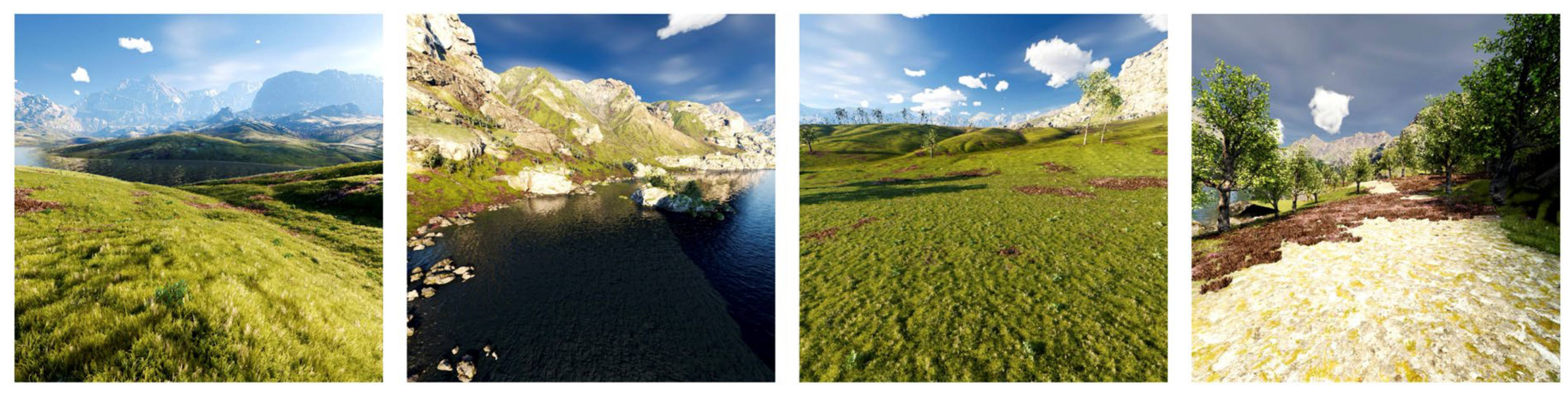
Figure 4 provides several visual examples randomly sampled from the utilized dataset. The setup includes forward-looking stereo RGB cameras and a downward-looking camera. Flight altitudes are randomly distributed at low levels, featuring diverse trajectories that incorporate various attitude changes, including pitch, roll, and yaw. The dataset covers two typical unstructured environments, namely Kite and PLE, and renders the same trajectories under seven different weather conditions. Since our method focuses on optimizing depth estimation for UAV oblique imagery, we selected 15 trajectories from two weather scenarios for training, 5 trajectories for validation, and 5 trajectories for testing. These trajectories are mutually disjoint, resulting in 6000 training images, 1500 validation images, and 1500 test images. To improve computational efficiency, we resized the original images to 512 × 512 pixels. We also sampled one frame every five frames to meet the requirements of self-supervised monocular depth estimation. For evaluation, since the dataset provides ground truth depth, we adopted median scale alignment and set the depth range to 1–150 m.
4.1.2. UAVID Dataset
The original UAVid [
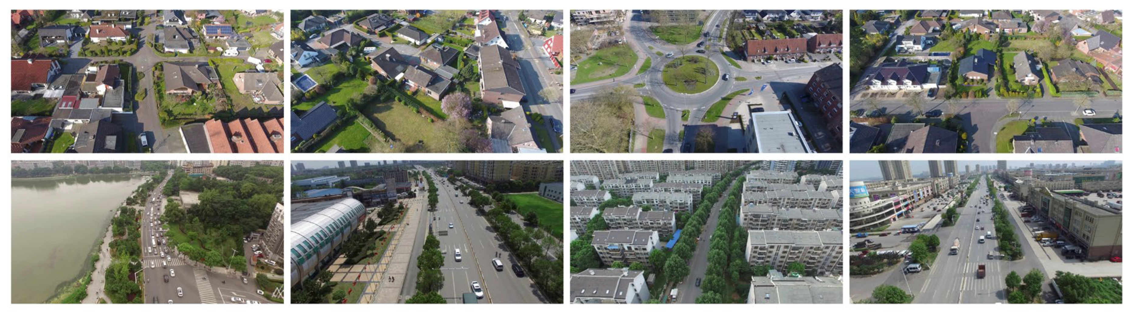
28] is a low-altitude UAV oblique imagery dataset specifically designed for complex urban scenarios, collected from two distinct regions: Wuhan, China, and Gronau, Germany. Some of the samples are shown in
Figure 5. During data acquisition, the UAV maintained an altitude of 50–100 m and a flight speed of 10 m/s, with the camera tilt angle fixed at 45°. The captured images feature high resolutions of either 4096 × 2160 or 3840 × 2160, encompassing a diverse range of common object categories typical of urban street views. During training, we followed the split protocol of UAVid-Depth, a derived dataset proposed by Madhuanand et al. [
11]. The Germany subset contains seven sequences sampled at 5 fps, while the China subset contains 30 sequences sampled at 1 fps. To improve the efficiency of model training, the two subsets were jointly used for training. The input images were resized to 640 × 320. As a result, the training set contained 5762 images, the validation set contained 493 images, and the test set contained 179 images. For evaluation, since UAVid itself does not provide ground-truth depth, the dataset uses the COLMAP structure-from-motion (SfM) [
16] algorithm to reconstruct reference depth maps for model evaluation. In the quantitative evaluation, we adopted a median scaling strategy. Following [
11], the value ranges of both the estimated depth and the reference depth are restricted to the 5% to 95% interval of the overall depth distribution. The ratio between the medians of the two maps was then computed as the scaling factor and multiplied by the estimated depth map for scale alignment. The evaluation was performed sequentially on individual images.
4.2. Implementation Details
All experiments were implemented using PyTorch 1.13.1 and run on a single NVIDIA RTX 3090 GPU. The AdamW optimizer is adopted to train the network. We set the total training epochs to 50 and fix the batch size at 12. For the learning rate schedule, we apply
during the initial 20% of the epochs, and then drop it to
for the rest of the training phase. To achieve faster convergence and robust initial features, the weights of both the depth and pose encoders are initialized from ImageNet [
32]. Furthermore, common data augmentation strategies, such as random horizontal flips and color jittering (brightness, contrast, and saturation), are utilized during the training process.
4.3. Evaluation Metrics
To quantitatively assess the performance of our proposed depth estimation framework, we adopt the standard evaluation proposed in [
7,
8,
11,
12,
33]. Our comprehensive evaluation relies on seven established metrics, encompassing four error-based indicators and three threshold-based accuracy criteria. The formulations are defined as follows:
Absolute Relative error (). This metric scales the estimation error by dividing the absolute depth difference from the true depth value, reducing the effect of the error with increasing distance, as shown in Equation (12).
Squared Relative error (). This metric uses a squared term to penalize larger depth errors, as shown in Equation (13).
Root Mean Squared Error (). This metric computes the standard deviation of the prediction errors. Since the discrepancies are squared before averaging, this metric is highly sensitive to large localized errors, providing a rigorous reflection of the overall measurement precision, as shown in Equation (14).
Root Mean Squared logarithmic error (). This metric compresses the dynamic range by transforming both the predicted and true depth values into a logarithmic space before calculating their discrepancy. It balances the influence of close-range objects and distant backgrounds, as shown in Equation (15).
Accuracy with threshold (
). This metric computes the percentage of valid pixels whose predicted-to-true depth ratio falls within a specified error margin. Following standard conventions, we measure the inlier ratios under three progressively relaxed strictness levels:
,
,
, as shown in Equation (16).
In these equations, and correspond to the predicted depth and the actual ground-truth depth at pixel i. T represents the aggregate count of valid pixels across the evaluated frame. Furthermore, to maintain a fair comparison in our comparative analysis, all models involved in the comparison were trained and evaluated under the same split scheme and sampling protocol, with consistent scale-alignment rules and evaluation metrics.
4.4. Quantitative Results
We evaluate our approach against several typical self-supervised depth prediction baselines.
Table 1 shows that the proposed network obtains the top results on the MidAir [
26] dataset. It surpasses earlier models, especially on the
and
metrics. This confirms that our design has a strong capability to process long range dependencies. Conversely, standard CNN models like Monodepth2 [
7] and MRFEDepth [
12] perform poorly in this scenario due to their static receptive fields. This underperformance is likely attributed to the prevalence of low-altitude flight, rapid pose changes, intense illumination variations, repetitive textures, and unstructured terrain, which cause traditional methods to be highly susceptible to depth blurring. While MonoViT [
9] achieves strong results by leveraging the global receptive field of a heavy Vision Transformer [
34], it comes at the cost of a massive parameter count (27.9 M). Compared with MonoViT, our model achieves promising results with significantly fewer parameters (approx. 3.1 M), indicating that correcting perspective distortion via DDaM may be a more efficient strategy for processing high-dynamic aerial imagery than simply stacking Transformer blocks.
Table 2 presents the evaluation results on the UAVid [
28] dataset, where all models are compared directly against the baseline. The results indicate that the integration of DDaM and Coordinate Attention Mechanism significantly boosts performance over the baseline, with the average
decreasing from 9.790 to 8.893. This demonstrates that our method can effectively calibrate oblique and perspective distortions in real-world aerial imagery, exhibiting high utility for practical applications.
Furthermore, we observed that the quantitative error metrics on the MidAir [
26] virtual dataset are numerically higher than those on the UAVid [
28] real-world dataset. The underlying reason is that the pseudo-ground-truth depth maps in the UAVid dataset were reconstructed using COLMAP’s Structure-from-Motion (SfM) pipeline, which cannot reconstruct sparse and weakly textured regions. Consequently, only the most predictable textured pixels are involved in the model evaluation. In contrast, MidAir [
26] provides fully dense absolute depth covering every challenging pixel across an expansive depth range. Therefore, the metrics on MidAir [
26] reflect a more comprehensive and authentic assessment of the model’s capability to handle extreme geometric ambiguities in aerial scenarios.
4.5. Qualitative Results
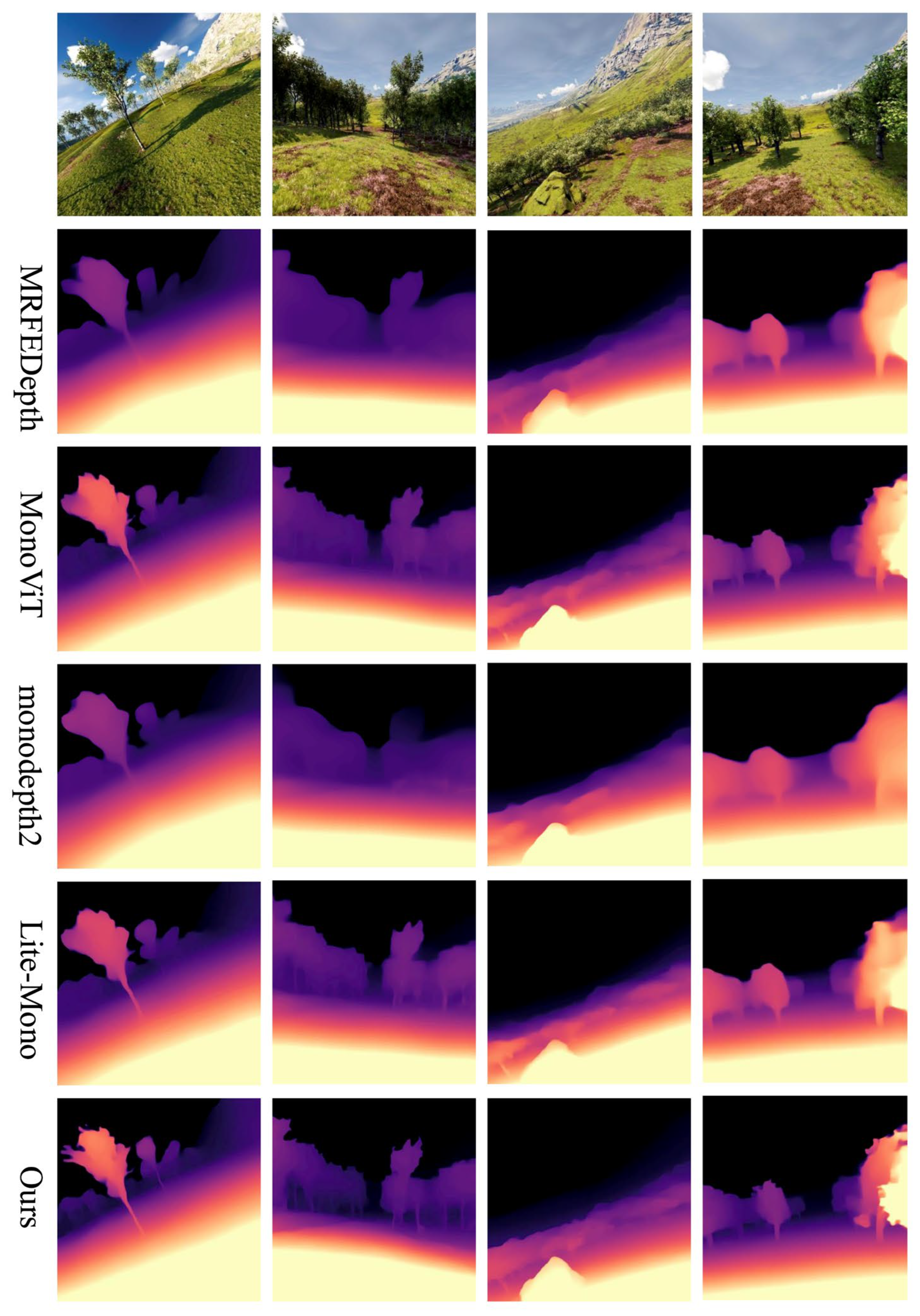
We conduct qualitative experiments on the MidAir [
26] dataset, with the visual comparisons presented in
Figure 6. Oblique aerial perspectives disrupt the epipolar constraints and geometric consistency between consecutive frames, which often causes the photometric error computation of conventional models to fail. To validate the effectiveness of DDaM and Coordinate Attention Mechanism, we select three oblique UAV scene images and one regular horizontal-view image. We train three conventional Monocular Depth Estimation (MDE) models (MonoViT [
9], Monodepth2 [
7], and Lite-Mono [
8]) and one UAV-specific MDE model (MRFEDepth [
12]). Our method achieves the best visual results in both oblique and horizontal images. In oblique scenarios, benefiting from the precise spatial coordinate anchoring provided by Coordinate Attention Mechanism, our method preserves more structural details and sharper edges for tree outlines. The static receptive fields of traditional CNN models are highly susceptible to mismatch caused by camera roll; consequently, models like Monodepth2 [
7] and MRFEDepth [
12] completely blend the trees with the background behind them. In contrast, by relying on DDaM to dynamically adjust the network’s feature extraction capability across different directions, our method accurately recognizes the foreground stone scene information while precisely delineating the outlines of the objects behind it. In the fourth image, other methods suffer from spatial information loss in dense forest areas due to consecutive downsampling operations, resulting in varying degrees of depth ambiguity. Meanwhile, our method clearly preserves the leaf details on the right edge and maintains crisp structural outlines even in the dense central regions. Experimental results indicate that our method excels in depth estimation for oblique aerial imagery while continuing to predict highly accurate results in regular horizontal-view scenarios.
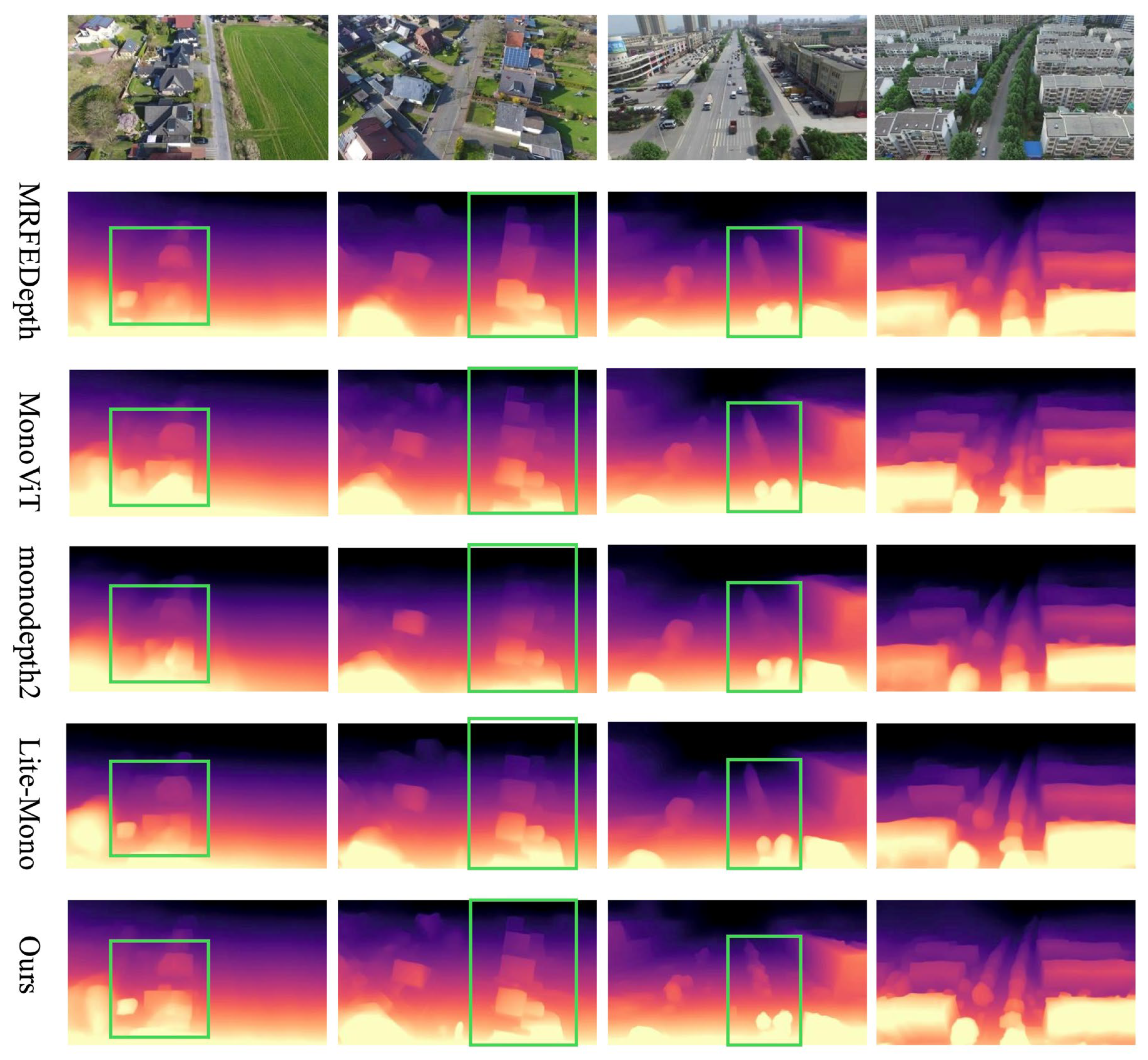
We also conduct qualitative experiments on the UAVid [
28] dataset, with the visual comparisons presented in
Figure 7. Unlike the synthetic MidAir [
26] dataset, the real-world UAVid [
28] dataset more closely reflects practical application scenarios. Furthermore, real-world challenges such as complex scenes, overexposure, shadows, and lens flare disrupt local pixel gradients, thereby exacerbating the difficulty of feature matching in self-supervised learning. We select four images representing different scenarios, including one with a large pitch angle, one oblique image with a large roll angle, and two regular-view images. When confronted with large and textureless rooftops, conventional methods struggle to establish effective smoothness constraints, leading to blurred depth predictions. Conversely, by leveraging the long-range directional dependencies captured by Coordinate Attention Mechanism, our method predicts highly smooth surfaces with crisp boundaries for these rooftops. In the third image, the horizontal obliqueness introduces perspective distortion. By compensating for the geometric distortion with DDaM and increasing the sampling density along the vertical direction, our method produces sharper contour details for the roadside trees and building edges. Although MonoViT [
9] also achieves competitive depth estimation results, our model demonstrates superior performance in handling complex scenes and weakly textured regions. Moreover, its parameter count (27 M) is significantly larger than those of other models, particularly ours (only 3.1 M). This indicates that our method achieves superior performance with lower model complexity.
4.6. Ablation Study
We also conducted several ablation experiments to validate the performance improvements brought by our model, using Lite-Mono [
8] as the baseline. The results are summarized in
Table 3. Our analysis shows that incorporating DDaM into the encoder of the depth network effectively corrects the geometric distortions caused by UAV motion, providing a more stable feature space for subsequent encoding stages. Simultaneously, integrating the Coordinate Attention Mechanism into the deeper layers of the encoder leads to a significant reduction in RMSE and Sq Rel metrics. This demonstrates its ability to capture long-range spatial dependencies along both horizontal and vertical directions, thereby reducing depth uncertainty in low-texture regions.
Furthermore, we observed that integrating only the Coordinate Attention module into the encoder did not yield significant performance gains; in fact, some metrics even exhibited slight degradation. We hypothesize that this is because applying the Coordinate Attention module directly to uncalibrated or distorted feature maps further exacerbates the erroneous relative spatial relationships within the features. To verify this hypothesis, we designed a set of quantitative experiments by evaluating the performance of the baseline model integrated with various attention modules on the UAVid [
28] dataset, as shown in
Table 4.
We introduced various attention modules into both the baseline and the DDaM-integrated model, respectively. The results in
Table 4 show that in the UAVid dataset, all isolated attention mechanisms struggle to improve the performance of the baseline. Compared with other attention methods, Coordinate Attention focuses more on precise positional relationships, while DDaM rectifies the feature space into a normalized standard perspective, providing a geometric prerequisite for the network. Consequently, all performance metrics improved to varying degrees. Furthermore, Coordinate Attention enhances the dynamic multi-scale perception of DDaM. This synergistic mechanism ensures that the model effectively captures long-range dependencies while maintaining structural consistency, enabling the depth estimation network to reconstruct clearer boundaries and richer local details.
5. Conclusions
This paper proposes a lightweight self-supervised monocular depth estimation method for oblique UAV imagery, aiming to improve the accuracy of depth prediction in UAV scenarios. We integrate a Dynamic Direction-Aware Module (DDaM) into the encoder of DepthNet, which learns affine transformation parameters from global contextual information and dynamically adjusts the spatial sampling grid to rectify distorted geometric features. In addition, we introduce Coordinate Attention into DepthNet by decomposing spatial pooling into two one-dimensional direction-aware feature encodings along the horizontal and vertical axes, thereby enhancing the model’s ability to represent spatial positional information and further improving the accuracy of depth prediction.
Experiments on the MidAir synthetic dataset and the UAVid real-world dataset demonstrate that the proposed method outperforms the compared baseline methods and significantly improves depth prediction accuracy in UAV scenarios while maintaining an extremely low parameter count. In future work, we plan to deploy the proposed lightweight model on embedded UAV platforms to support real-time autonomous navigation and obstacle avoidance in complex outdoor environments.