Article

The History of a Pinus Stand on a Bog Degraded by Post-War Drainage and Exploitation in Southern Poland

by
Anna Cedro
1,*,
Bernard Cedro
1,
Katarzyna Piotrowicz
2,
Anna Hrynowiecka
3,
Tomasz Mirosław Karasiewicz
4 and
Michał Mirgos
5
1
Institute of Marine and Environmental Sciences, University of Szczecin, 16 Mickiewicza Str., 70-383 Szczecin, Poland
2
Institute of Geography and Spatial Management, Jagiellonian University in Kraków, 7 Gronostajowa Str., 30-387 Kraków, Poland
3
Polish Geological Institute-National Research Institute, Marine Geology Branch, 5 Kościerska Str., 80-328 Gdańsk, Poland
4
Institute of Earth and Environmental Sciences, Faculty of Earth Sciences and Spatial Management, Nicolaus Copernicus University in Toruń, 1 Lwowska Str., 87-100 Toruń, Poland
5
Nadleśnictwo Nowy Targ, 70 Kowaniec Str., 34-400 Nowy Targ, Poland
*
Author to whom correspondence should be addressed.
Appl. Sci. 2025, 15(9), 5172; https://doi.org/10.3390/app15095172
Submission received: 25 March 2025 / Revised: 29 April 2025 / Accepted: 30 April 2025 / Published: 6 May 2025

Abstract

:
A dendrochronological study was conducted on a submontane raised bog, Bór na Czerwonem, in the Orava–Nowy Targ Basin in Southern Poland. In the past, the bog was drained to enable peat extraction. In recent years, a number of measures considered as active protection were undertaken, including the construction of ridges and locks, filling of the drainage trenches, and clearance of most of the tree stand on the bog dome. Pinus sylvestris, P. × rhaetica, and P. mugo were the focuses of the study, which aimed to determine the age of the genus stand and its age structure and to identify the factors influencing tree ring width. The age of the trees indicates a post-war succession induced by large-scale drainage in 1942, although single trees were present on the bog dome as early as the late 19th century, and probably earlier. High values of pith eccentricity at ground level testify to substratum instability and the impact of strong winds on tree ring formation. The growth–climate relationships change with the progressive climate change: the significance of insolation increases, while the significance of the absolute air temperature decreases. The thermal and pluvial conditions of the summer in the previous growth season, however, make the strongest impact on the tree ring width in the following growth season. The health of the trees left growing on the bog, due to the constantly rising water level, will likely deteriorate, and a decreasing number of seedlings will be observed. A full assessment of the conducted restoration efforts, however, will be possible after years of monitoring of the bog environment.

1. Introduction

Over the last several hundred years, due to human activity, wetlands and peatlands have been exposed to enormous pressure, predominantly by drainage and transformation for human hand use. This trend has intensified over the last 150–200 years, with a consequent, often irreversible loss of valuable natural habitats. Wetlands, including peatlands, provide many essential—and, until recently, undervalued—ecosystem services: they retain water in the environment (especially significant during periods of increasingly severe and prolonged droughts); maintain a high level of groundwater (during the period of their intensive use for irrigation and both industrial and domestic needs); prevent/restrict fires; are habitats for numerous plant and animal taxa (often very rare and protected), thus contributing to maintaining high biodiversity; and absorb and sequester carbon (CO2), increasing the resistance of ecosystems to climatic changes [1,2,3,4,5,6]. Such areas may also be valuable eco-tourist destinations.
A remarkably positive trend in the last several decades has been the restoration of wetlands, which is increasingly supported by science and society. It is a response to the frequent failures of the traditional passive protection of such areas, to progressive habitat and biodiversity loss, and to strong habitat fragmentation. More attention is given to wetlands and peatlands, they are targeted by more numerous studies (most frequently interdisciplinary), and funding for the restoration of previously degraded habitats is increasing [4,5,7,8,9,10].
Raised bogs in montane and submontane areas of Poland have most frequently been subjected to drainage and/or peat extraction. These have resulted in a considerable lowering of the water level within the bogs, the frequent cessation of peat-forming processes, a transformation of the upper layers of peat into muck, peatland fires, floral turnovers, and most of all, the expansion of forests into previously unforested areas [11,12]. The Bór na Czerwonem Reserve is an example of a raised bog that initially, despite protection, was exposed to intense human impact but underwent restoration in recent years. The results presented here concern dendrochronological analyses performed on a partly cleared tree stand comprising Pinus sylvestris and P. mugo, and partly on trees remaining on the bog dome (P. sylvestris and P. × rhaetica). The numerous interdisciplinary studies performed as part of the ongoing restoration efforts will be presented in future publications.
The aim of the present study was to (i) determine the age of the trees growing in a stand on the Bór na Czerwonem bog and elaborate its age structure, and to (ii) identify the anthropic and climatic factors shaping tree ring growth in the studied trees.

2. Materials and Methods
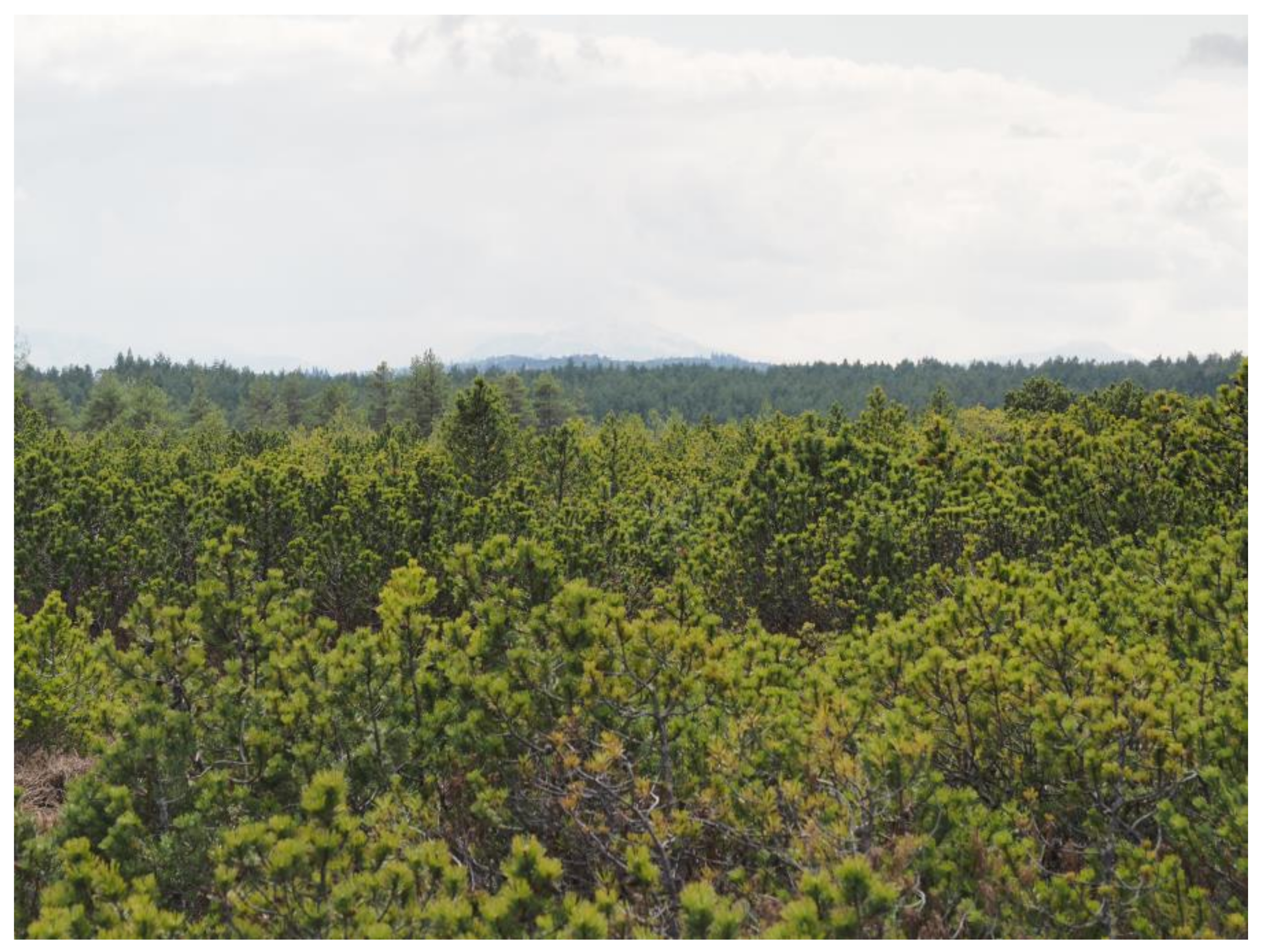
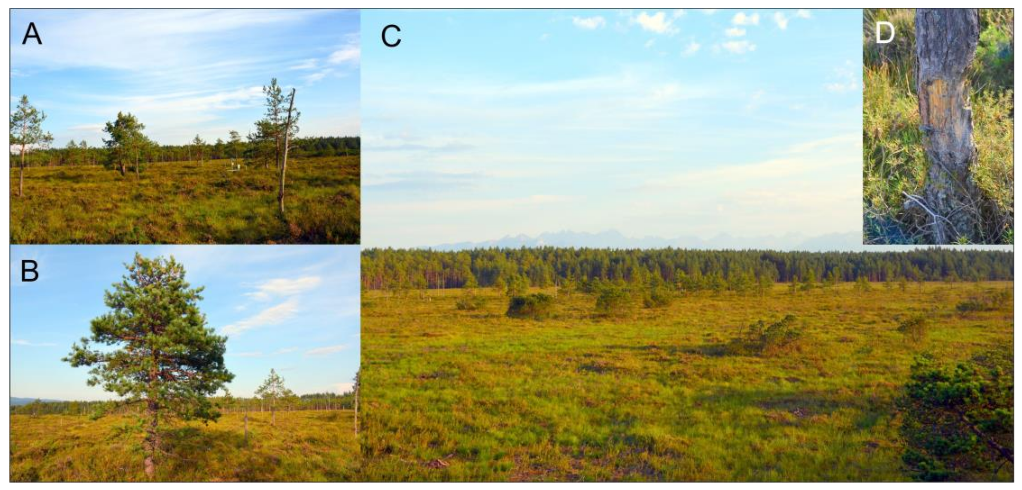
2.1. Study Area

The Bór na Czerwonem bog is located in Southern Poland in the Lesser Poland Voivodeship within the Nowy Targ commune. The nature reserve at this site was established in 1925, mostly owing to the efforts and determination of Prof. Władysław Szafer. Initially, the reserve covered 5 ha of the bog [13]. Since 1948, the entire bog area has been owned by the state, and at present, it is managed by the Nowy Targ Forest Inspectorate. It belongs to the so-called Orava–Nowy Targ Peatlands, located within the Orava–Podhale Depression macroregion, in the Orava–Nowy Targ Basin mesoregion [14,15] which is located in the immediate vicinity of the city of Nowy Targ and the montane river Biały Dunajec. The location of the bog is marked by the geographic coordinates 49°27′31.91″ N and 20°02′29.14″ E. The studied bog represents a domed raised bog. At its highest point, it reaches an elevation of 617.3 m a.s.l., and the elevation of its surroundings is lower by about 2.2 m. It is about 1000 m long and 500 m wide (Figure 1). The central part of the reserve comprises the bog dome, occupying an area of about 36 ha. At present, the entire reserve area is about 114.66 ha, and its buffer zone is 68.4 ha [16].
According to Łajczak [17,18], the bog arose on a Last Glacial river terrace (Würm, Weichselian, MIS 2–4), at the foot of a scarp of a Mindel-aged terrace (Elsterian, MIS 12–16). The origin ages of the peatlands of the Orava–Nowy Targ Basin vary. The research by Obidowicz [19] indicates they are no older than 10,000 years. There are exceptions, however, for instance, the Grel mire, whose base was dated at the Oldest Dryas [20], or Puścizna Rękowiańska (Wielka), with a record extending back to the Younger Dryas [21]. Due to the exploitation of the bog, as well as its drainage and climate changes, the bog area has shrunk significantly: from 0 to 35% in one part and by 35–70% in the other part [17,18]. The bog developed on clayey covers, and the age of its base is estimated at ca. 7000 years (6930 ± 240 BP) [22]. Studies on adjacent sites indicate that peatlands within the Orava–Nowy Targ Basin, including Bór na Czerwonem, are underlain by gravels and clays of the Czarny Dunajec fan, formed during the Last Glacial [23]. The peat deposit was formed within a linear depression, and the bog evolved from an initial mesotrophic mire to a raised, typical ombrogenous bog. The bottom layer was produced by a SphagnoPiceetum assemblage, as evidenced by numerous trunks [24], probably of Picea abies and/or Pinus sylvestris, occurring in this layer. The peat-forming process was initiated in aquatic conditions, under ombro-soligenous supply during the Atlantic period of the Holocene. The peat comprised within the dome is, according to Wójcikiewicz [22], of the transitional type. Our own observations indicate a raised type for the bog, with a clearly delimited dome and lagg, mostly fed by precipitation and partly by shallow groundwater [17].

2.2. History of the Flora

The history of this part of the Orava–Nowy Targ Basin has been reconstructed based on palynological analysis of the Bór na Czerwonem sediments [19,24] and—due to hiatuses present in the record from this site—also other mires located within this belt: Puścizna Rękowiańska [19,21] and Grel [20,25]. The withdrawal of the Tatra Mountain glaciers at the end of the Weichselian brought about an absolute dominance of sparse pine and pine–birch assemblages in this area during the oldest period of the Holocene—the Preboreal. Further climate warming during the Boreal period caused the dominance of Pinus assemblages with Picea and Corylus assemblages. During the warmest and most humid-Atlantic period, the dominant tree genus was Picea, and an important part in the landscape was played by deciduous forests with Quercus, Tilia, and Corylus and by riparian forests with Alnus, Ulmus, and Fraxinus in river valleys. The Subboreal and Subatlantic periods were characterized by the dominance of AbiesFagus assemblages with abundant spruce. In the final phase, changes occurred in the taxonomic composition of the tree stands caused by the expansive human economy; i.e., the PiceaAbiesFagus assemblages were superseded by Pinus [21,23,25]. The water relations within the bog were disrupted as a consequence of intensive drainage of the bog dome in the 20th century and the extraction of the peat deposit in its northern part. Due to the lowered water level, P. sylvestris and P. mugo colonized the bog dome in numbers previously unrecorded in the bog’s history. Pinus sylvestris and Pinus mugo have grown within the Bór na Czerwonem bog throughout its Holocene history in variable proportions [24]. Never before, however, have they formed such thick cover, as indicated by small quantities of the Pinus sylvestris pollen type recorded in sediments from the studied bogs from the Atlantic to the latest Subatlantic period. These species were always present in low abundance, basically as single trees and/or shrubs [21,24].

2.3. Flora on the Bog Dome

Within the dome of the Bór na Czerwonem bog, the undergrowth layer is abundantly represented by various species of Sphagnum and other bryophytes. Wild rosemary (Ledum palustre), bog bilberry (Vaccinium uliginosum), lingonberry (Vaccinium vitis-idea), and hare’s-tail cottongrass (Eriophorum vaginatum) occur in patches. As a result of prolonged human impact via draining ditches and peat mining, the bog dome has been drained to an extent that has enabled the occurrence of tree species: the Scots pine (Pinus sylvestris L.), the mountain pine or the dwarf mountain pine (P. mugo), and their natural hybrid Pinus × rhaetica (Figure 2). The dome lagg area also became colonized by trees. A coniferous swamp habitat developed here. Until the 1950s, the bog dome was intensely mined, despite the existence of the nature reserve. According to the data included in the provisions of the Bór na Czerwonem Reserve management plan for the 1970s–1980s, the age of the P. mugo trees growing in patches on the bog dome was estimated at 10–20 years. If this was the case, in 2024, when most of the trees growing on the dome were cleared, the trees should have been 64–74 years old. The age of the tree stand surrounding the dome is estimated at 80–130 years, based on publications of the Bureau for Forest Management and Geodesy [26,27].

2.4. Active Protection in the Bór Na Czerwonem Reserve

Since 2010, the Forest Inspectorate at Nowy Targ has been undertaking a number of measures aiming at active nature protection. Since 2021, the project “Carpathians Unite—Conservation of Orawa–Nowy Targ Peatlands” has been carried out by the Nature and Human Foundation within the reserve confines. What distinguishes that project from other projects carried out in parallel in other peatlands in the Orava–Nowy Targ Basin is that it secured long-term funding for research, both at a preparatory stage preceding protective measures and after their completion, to enable observation its outcomes. Such long-term monitoring enables an accurate assessment of the efficiency of the protective measures, which ensures the protective measures bring a positive environmental effect. The research is carried out by a group of experts comprising approximately 20 members. To date, the following measures have been undertaken as part of active protection:
(1) The construction of locks to slow down surface runoff and enhance water retention in the peat bog dome, which is designed to limit the process of forest succession and restore the drainage-less character of the area; (2) the clearance of 85–90% of trees from the bog dome in order to restore the typical, unforested form of the bog, and to prevent the overdrying of the surface peat layers due to transpiration; (3) girdling of the largest pine trees by the removal of bark and phloem along the trunk circumference (Figure 3D); (4) the construction of an 80 m long dike in the northern part of the dome, where peat was still being mined as late as the 1950s, in order to limit the drainage of water from the peat bog, increase retention, and promote habitat restoration in the former mining part; (5) filling part of the ditches draining the bog dome. These restorative measures and their effects will be extensively reported on in future publications.
As part of the measures undertaken in the reserve, an educational path was constructed, comprising a wooden pier and an observation deck, and intensive educational activity is being carried out.

2.5. History of the Bog’s Exploitation
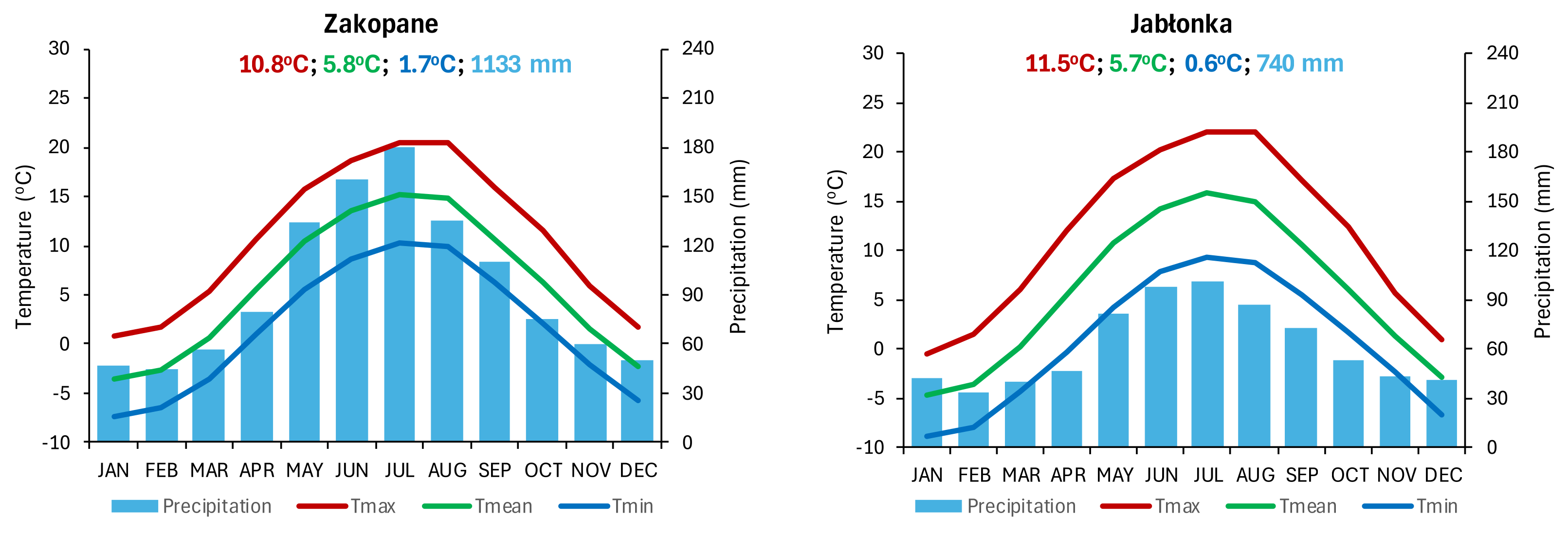
The bog area has been exploited since at least the late 19th century, but also in the early 20th century, when its northern part was destroyed during the construction of a military airfield, which was transformed into a civilian facility following the Second World War. The next phase of exploitation took place during the Second World War, when Jewish forced workers—initially 30 (June 1942) then, later, 300 (August 1942), divided into five groups—were forced to extract peat. The first group removed the surface peat layer (about 1 m thick), to be used as fertilizer. The second team excavated peat down to a depth of about 3 m. The third team used carriages to transport the peat to a storage site, the fourth group formed the peat into bricks and dried it, and the last group, following 2–3 weeks of drying, stacked the peat into large pyramids [28]. Gazeta Żydowska [Jewish Journal] from 14 August 1942 reports [28] that daily peat production equaled about 150 m of the peat bog surface, i.e., about 230 carriages loaded with peat lumps. The peat was to be used as fuel for the coming winter. The description of peat extraction mentions preparatory work prior to mining by making the bog area suitable for exploitation. The memoirs of the forced workers describe being taken over a long distance to work on the bog, the cruelty of guards and gestapo, 12 h long days of exhausting work, and being forced to perform other jobs, e.g., digging mass graves for Jews in the Nowy Targ cemetery [28]. One of the preparatory tasks must have been digging ditches and draining excess water from the exploited area, which was previously—according to a description—exploited to a small extent, and even that modest exploitation followed no specific plan (Gazeta Żydowska, 14.08.1942 r. no. 96, p. 5, citations following [28]). Despite the establishment of the nature reserve, peat extraction from the dome was carried out until the 1950s.

2.6. Climate

According to climatic regionalizations, the study area is located in the Carpathian region, montane and submontane, within the intramontane valley subdivision [29,30,31], and in a temperate climatic zone with a mean annual air temperature from 4 to 6 °C [32]. As in the vicinity of the reserve there are no weather stations with long time series of meteorological measurements available, for the present study, we used data from Zakopane (49°17′ N, 19°57′ E, 855 m a.s.l.) and Jabłonka (49°28′ N, 19°42′ E, 617 m a.s.l.). The data span is 1971–2020. Both weather stations belong to the Institute of Meteorology and Water Management—National Research Institute [33]. They are located about 20 km S and 25 km W, respectively, from the study area.
In Zakopane, the mean air temperature (Tmean) throughout the period of 1971–2020 equaled 5.8 °C and ranged from −2.7 °C in January to 15.1 °C in July (Figure 4). The Tmean in Jabłonka was just 0.1 °C lower (5.7 °C), but it varied over a broader range compared to Zakopane (from −4.8 °C to 15.8 °C; Figure 4). The annual variability in the Tmax indicates that in Zakopane, even in winter (December–February), the Tmax was above 0 °C. Jabłonka and the Bór na Czerwonem Reserve are located in a basin, in which thermal inversions occur frequently, with temperature drops below 0 °C. This is why the lowest Tmax values in January of each year were below that value, on average −0.5 °C (Figure 4). The monthly mean Tmin values for Zakopane ranged from −7.4 °C in January to 10.3 °C in July, and for Jabłonka for the same months, they ranged from −9.0 °C to 9.3 °C. Whereas for Zakopane, the period with mean Tmin values below 0 °C lasted from November (−2.0 °C) to March (−3.6 °C), it was longer for Jabłonka: from November (−2.4 °C) to April (−0.3 °C) (Figure 4). In individual years of the study period, ground frost, i.e., days with both Tmax > 0 °C and Tmin < 0 °C, also occurred at both stations in the summer months (June–August). For this reason, the period of potential ground frost occurrence is all year long. Nonetheless, considering the frequency of ground frost occurrence, the reserve is more exposed to ground frost than Zakopane, which is located higher above sea level. Multi-year air temperature variability (Tmax, Tmin, Tmean) in the studied 50-year period displays a statistically significant increasing trend at both weather stations, equal to 0.3–0.5 °C/10 years. Notably, this trend was the strongest for the summer months (June–August).
Zakopane belongs to a region with rather high atmospheric total precipitation. Through the period of 1971–2020, the mean annual total of precipitation equaled 1133 mm (Figure 4). Most of the rainfall occurred in summer (June–August), with a maximum in July (180 mm). Precipitation was the lowest during winter (December–February; about 45–50 mm) (Figure 4). The total precipitation for Jabłonka was lower, equal to 740 mm, ranging from 34 mm in February to 101 mm in July. The multi-year total of precipitation shows no statistically significant trend.
The annual variability in the number of days with snow cover—on average, 120 days a year in Zakopane and 91 days in Jabłonka—also testifies to the specific climate of the study region. Snow cover may potentially occur from October to May/June. The latest last day with snow cover recorded in Zakopane was 1 June 1977 (1 cm). In Jabłonka, the latest date on which snow cover was observed was 14 May 2019. Notably, however, on 1 May 1985, the thickness of snow cover in Jabłonka was up to 20 cm.
In Zakopane and in Jabłonka, the mean wind speed is relatively low, about 1.5 m·s−1. In the cool half-year, however, the study area is often under the influence of a very strong foehn-type wind, locally called “halny”, whose velocity may exceed even 15–20 m·s−1.

2.7. Methods

Cores (two per tree) were collected from trees using Pressler borers at 1.3–1.5 m above ground level during the vegetation season of 2024; hence, the last full increment in the chronology is the year 2023. Wood discs in cross-section were taken by the employees of the Nature and Human Foundation from the ground surface in December 2024, from trees previously cleared during the bog restoration in winter 2023/2024. In total, we collected cores from 23 trees and discs from 45 trees (Table 1). In the laboratory, samples were glued onto boards, dried, and sliced with a knife in order to obtain a clear view of the tree rings. In order to enhance tree ring boundaries, the sample surfaces were smeared with chalk. Tree ring width (TRW) was measured under a stereoscopic microscope down to 0.01 mm using LBD_Measure software(version 1.0) [34]. A total of 140 measuring radii and 7285 tree rings were measured.
Due to the high pith eccentricity, the large number of rings with compression wood, the large number of missing rings, and the low statistical and graphical agreement for the measurements from discs, we decided to base the chronology only on core samples. The samples from discs were the basis for the analysis of the age structure of the stand and pith eccentricity. In order to equalize the age obtained from the discs and cores, 10 years were added to the age of the trees obtained from the cores. During sampling, the cardinal directions were not determined. Local chronology was subsequently compiled using classic cross-dating methods. Based on the high visual similarity between dendrochronological curves and the high values of statistical indices (Student’s t-test and correlation coefficient), dendrochronological sequences were selected for inclusion in the chronology. Sequences that were the least visually and statistically correlated were rejected. Chronology robustness was tested using COFECHA, part of the DPL software package [35,36,37]. The expressed population signal (EPS) coefficient was also computed [38]. Age trend and autocorrelation were subsequently removed from the dendrochronological sequences selected for the chronology by means of an indexing process (a two-phase detrending technique that comprises fitting either a modified negative exponential curve or a regression line with a negative or zero slope) [35,36,39,40].
To study the growth–climate relationship, correlation and response function analysis was used. The average monthly air temperature (T), absolute monthly minimum temperature (TM), monthly total precipitation (P), and monthly insolation (IN) from June of the year preceding growth (pVI) to September of the growth year (IX) from the weather station in Zakopane were used for correlation and response function analysis. The analysis was performed separately for average temperature, absolute monthly minimum temperature, precipitation, and insolation, yielding r2 values (regression coefficients of determination) for each climate parameter [36,41,42]. Correlation and response function analysis was performed for two 21-year-long periods: 1982–2002 and 2003–2023. The following data from the station in Zakopane were used: T, TM, P, and IN. The selection of these two subperiods, 1982–2002 and 2003–2023, were based on observed shifts in global and regional climate systems, as well as the need to compare time intervals of equal duration. The year 2003 is widely recognized as the beginning of a new phase of accelerated global warming, characterized by a distinct rise in mean air temperature relative to the preceding period (1982–2002). Notably, 20 of the 21 warmest years on record occurred between 2003 and 2023 [43]. Since the extreme European heatwave of 2003, there has been a documented increase in the frequency and severity of heatwaves, including the occurrence of tropical nights, as well as episodes of intense precipitation and prolonged droughts. These trends have contributed to a rise in weather-related mortality and economic losses associated with extreme weather events [44]. Furthermore, since 2003, the behaviour of the El Niño–Southern Oscillation (ENSO) phenomenon has exhibited altered dynamics, with implications for global temperature and precipitation distributions. Cunningham et al. [45] report that, globally, both the frequency and intensity of extreme wildfires have more than doubled since 2003. In Poland, the mean temperature anomaly for the 2003–2023 period reached +1.3 °C relative to the climatological norm, compared to approximately 0.0 °C for the 1982–2002 interval [46] (2025). An additional justification for this temporal division lies in standard climatological methodology, which typically utilizes 30-year reference periods (e.g., 1961–1990, 1991–2020). The chosen 21-year intervals (1982–2002 and 2003–2023) provide a consistent basis for comparative analysis, facilitating the identification of trend changes and offering insights into the transition toward a climate regime increasingly influenced by anthropogenic forcing.
Pith eccentricity (POC—pith offset from the centre) is an offset of the pith relative to the centre of a cross-section of circular wood (e.g., stem/discs or a branch). POC is accompanied by an uneven width of tree rings in different parts of the section and a heterogenous wood structure. Pith eccentricity is often associated with stem eccentricity. POC in the trunk may be caused by the leaning of the tree, slope processes (in this case, within the bog), avalanches, or strong winds. Pith eccentricity occurs in trees growing on slopes and scarps. It is expressed using the POC index, ranging from 0 to 1, where 0 indicates no eccentricity, and increasing values signify an increasing proximity of the pith location to the bark. POC was calculated using the following formula [47,48]:
POC = r a v g r s h o r t r a v g ,   where   ravg = r s h o r t r l o n g 2
where ravg—average radius, rshort—shortest radius, rlong—longest radius.

3. Results

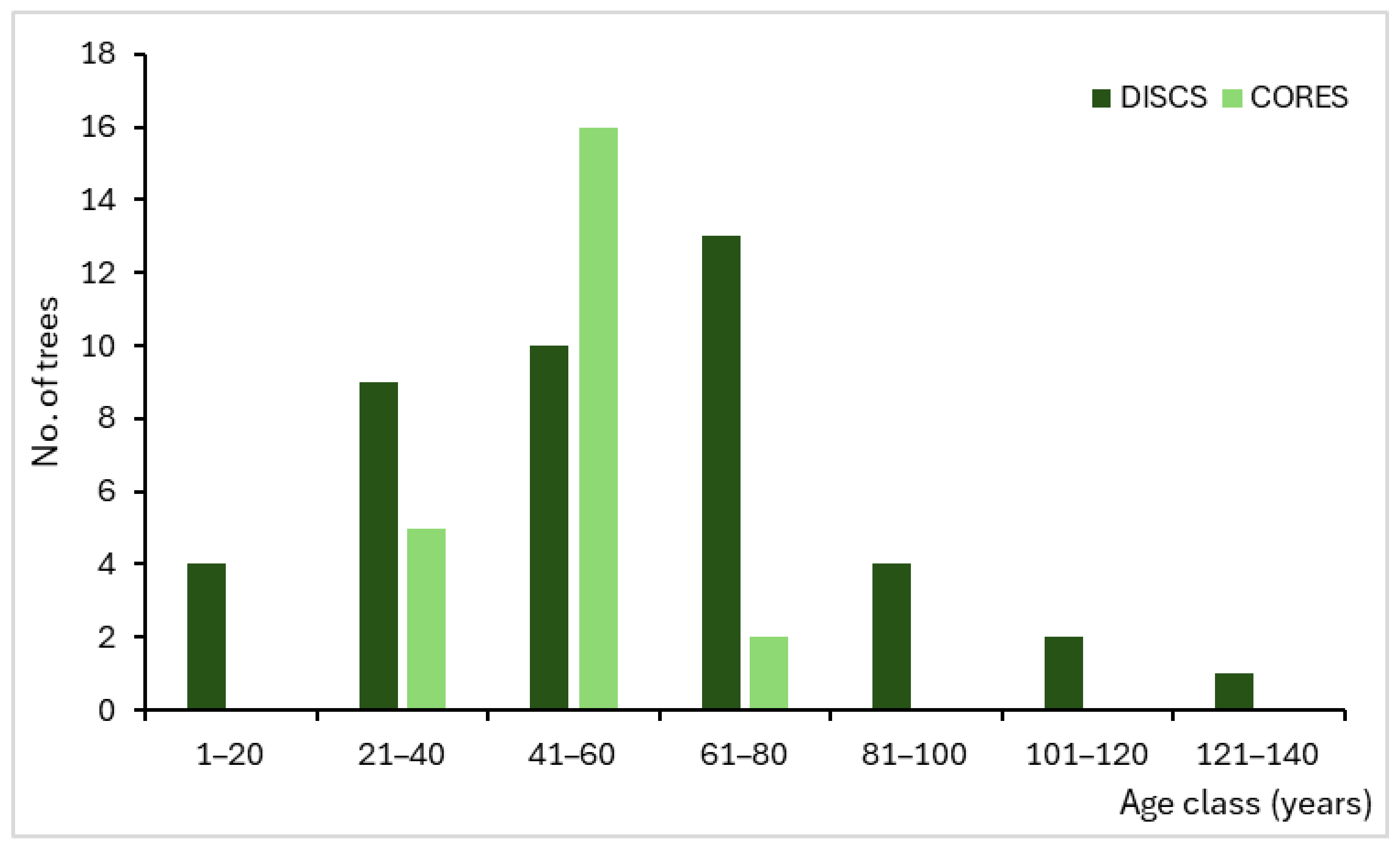
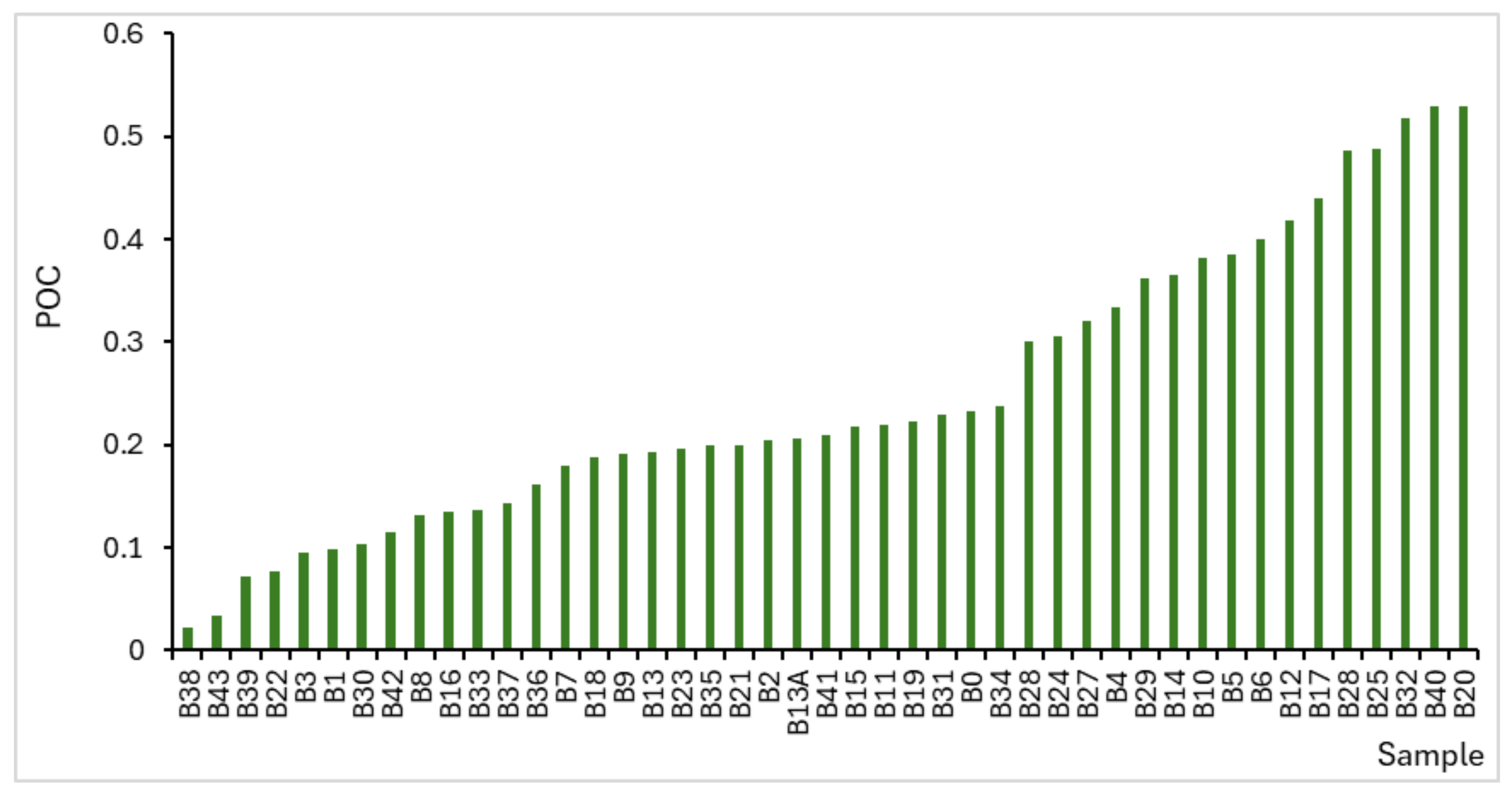
3.1. Age Structure of the Stand

The age structure of the tree stand growing in the Bór na Czerwonem bog was analyzed based on 45 discs and drillings from 23 trees. The lowest numbers of tree rings counted in discs were 16 (sample B39) and 17 (samples B36 and B34). The highest number of tree rings counted was 140 (sample B29). Only three trees were older than 100 years (101—B13, 103—B16, and 140—B29). A total of 56% of samples represented age intervals of 41–60 and 61–80 years, which corresponds to the years 1945–1965 (Figure 5). On average, samples from the discs were 58 years old, with a median equal to 60 years. The number of tree rings counted in the drillings was lower: the youngest trees were 35 years old (BC4, BC12, BC21), and the oldest were 69 years old (BC14). The average tree age was 49 years old, with a median equal to 50 years. Over 78% of the trees fell within the 41–60 years age class (i.e., 1965–1984). An analysis of the age structure of the studied tree stand indicates that most trees originated from after the Second World War. Only single individuals come from before this war. The variability in tree age does not support a planned afforestation of the peat bog area.

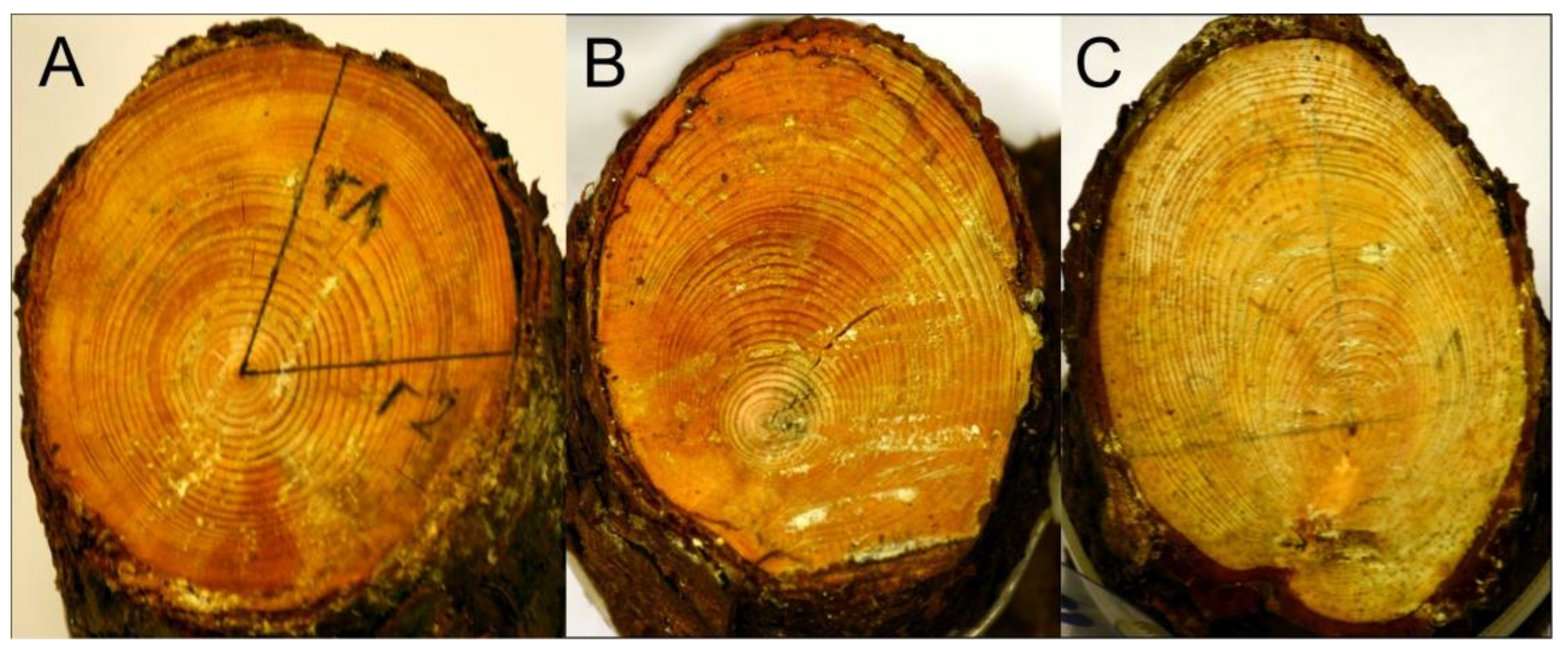
3.2. Pith Eccentricity

Pith eccentricity analysis was based on measurements performed on 45 discs. On average, the POC index equals 0.25 (Figure 6). The maximum POC value is reached in sample B20—0.53 (Figure 7C), and the minimum POC value is 0.02. The average POC value is the highest for the classes 81–100 years old (0.38) and 121–140 years old (0.36), and it was the lowest for the youngest trees aged 1–20 years (0.15) (Table 2). In addition to pith eccentricity, discs are characterized by a high number of tree rings with compression wood and a considerable number of missing rings.

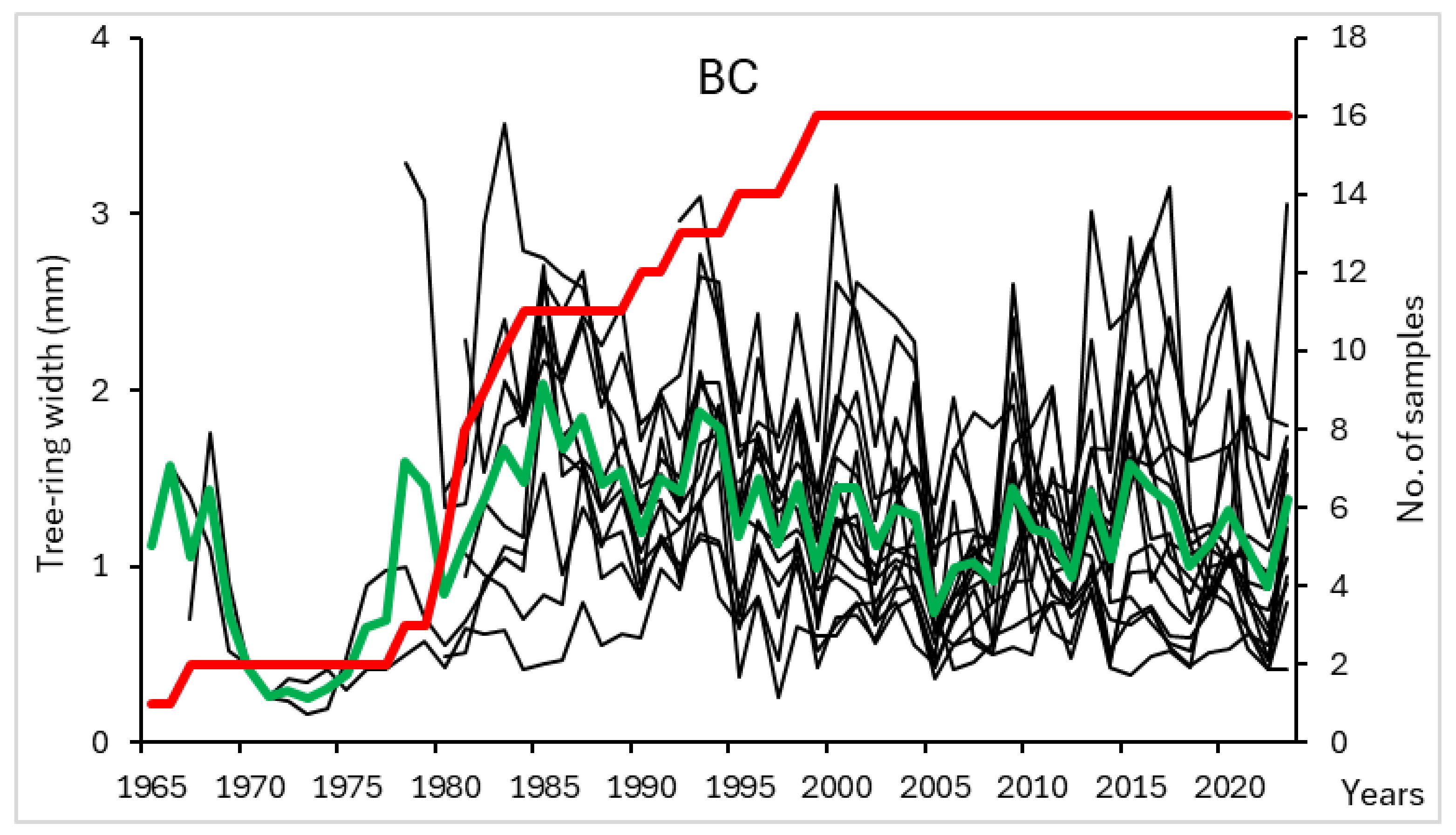
3.3. Tree Ring Chronology

The BC chronology, based on cores taken from P. sylvestris and P. × rhaetica growing in the Bór na Czerwonem bog, was compiled from 16 individual growth curves and spans 59 years from 1965 to 2023. For a period of 42 years (1982–2023), the EPS values exceed 0.85. The sequences included in the chronology are characterized by a high visual (Figure 8) and statistical (mean correlation: 0.587) convergence. The average tree ring width among the studied trees equals 1.2 mm/year, ranging from 0.8 (BC14) to 1.6 mm/year (BC15). The standard deviation (STD) for the tree ring chronology equals 0.546 mm and 0.332 mm for the indexed chronology. Autocorrelation order 1 (AC1) equals 0.613 and 0.539, respectively, and mean sensitivity equals 0.283 and 0.245, respectively. The chronology displays a slight decreasing TRW trend over the period of 1986–2005, and after 2006, the TRWs range from 0.9 to 1.6 mm/year (2008). The assembled chronology served as the basis for dendroclimatic analyses: correlation and response function analysis.

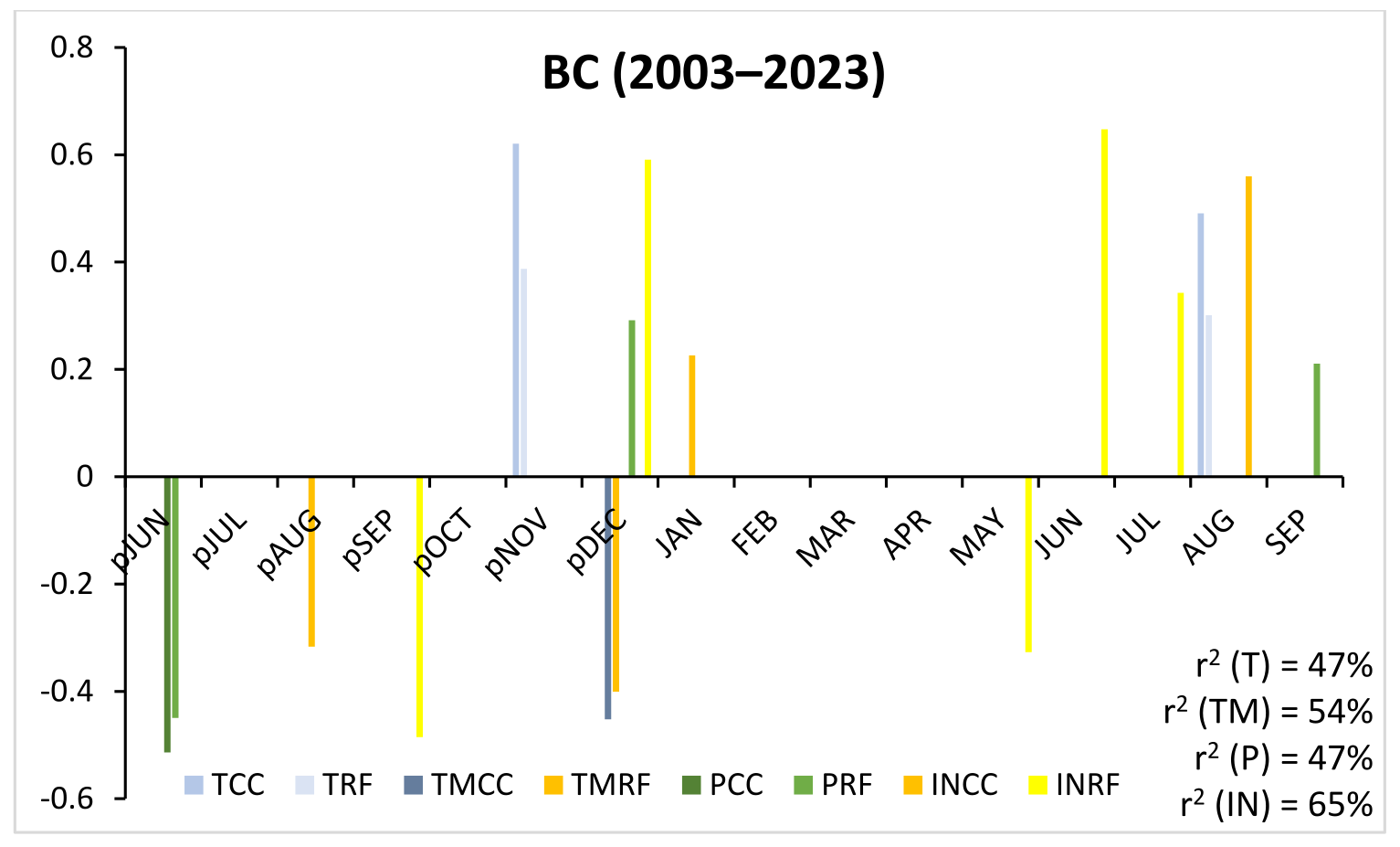
3.4. Dendroclimatology

The absolute minimum temperature (TM) made the strongest impact on tree ring widths over the period of 1982–2002. The determination coefficient for this parameter (r2) reached the highest value among the analyzed climatic factors, equal to 68%. Negative correlation coefficient values for TM were noted in pJUN and pJUL, and FEB and AUG. Positive values were noted only in pDEC and APR (Figure 9). For sunshine duration (IN), r2 reaches a value of 59%, with correlation coefficients showing positive values in pNOV, FEB, APR, and SEP, and negative values only for pDEC and MAY. For the relationships between growth and temperature and between growth and rainfall, r2 equals 50%. For temperature (T), negative correlation and regression values were noted for JAN, FEB, and JUN, and a positive value was noted for APR. For precipitation (P), negative values occur in pJUN, and positive values occur in JAN, MAR, and AUG.
A change in r2, strength, and periods of correlation for the analyzed parameters was observed for the period 2003–2023. The highest r2, equal to 65%, was noted for IN (a 6% increase compared to the earlier period) (Figure 9). Positive correlation values occurred in pDEC, JUN, JUL, and AUG, and negative values occurred in pSEP and MAY. r2 for TM reached 54% (a 14% drop relative to the earlier period). Negative correlation coefficient values for TM occurred in pAUG and pDEC, and a positive value occurred in JAN. Similar to the earlier period, r2 for T and P remained at a comparable level (47%, i.e., only a 3% drop relative to the earlier period). Only positive correlation and regression values were noted for T: pNOV and AUG. A negative value for P occurred in pJUN, and positive values occurred in pDEC and SEP.
A comparison of the growth–climate relationships for both analyzed periods indicates stable relationships in the summer of the previous growth season: negative coefficient values for TM and P. In the remaining seasons/months, the strength of the relationship changed. For instance, pDEC values shifted from positive to negative for TM and from negative to positive for IN. Relationships for late winter and early spring disappeared in the period of 2003–2023 (FEB, MAR, and APR), while—in the same period—in the vegetation season, the relationship strength increased for IN and decreased for P.

4. Discussion

The Bór na Czerwonem bog is one of the few remaining raised bogs in the Orava–Nowy Targ Basin. Although strongly desiccated and degraded, despite legal protection established 100 years ago, it remains in a good condition when compared to the remaining peatlands (17 domes no longer exist) [13]. Historical notes indicate that as late as the turn of the 19th century, the bog was virtually untouched. A document titled “Report on the establishment of a silviculture in the forests of the Nowy Targ city 1888” includes a description of the bog as an entirely inaccessible spot that can only be entered during severe frost [13]. Also, the description included in Gazeta Żydowska [Jewish Journal] from 1942 describes the bog as a place not suitable for mining (the area had to be made accessible for this purpose) and the very small extent of peat extraction up to that time [28]. In the local dialect of the inhabitants of the Tatra Mountains and Podhale, these areas are referred to as “puścizna”, which can be translated as an empty place, devoid of trees, indicating that the domes of the bogs were unforested. Also, the original name of the bog (“Na Czerwonem”) [24] compared to the name functioning after the Second World War (“Bór na Czerwonem”—“Bór” translates to “Woods”) confirms that the tree stand did not exist in the early history of the reserve. The first documented drainage works took place in the late 19th century (the construction of an ammunition depot) [49,50], as well as in the early 20th century during the construction of the military airfield in Nowy Targ. The airfield was later transformed into a civilian facility and is located immediately to the north of the bog. The extensive drainage associated with peat extraction since 1942 led to severe desiccation, a lowering of the water level, and bog degradation, as well as rapid forest succession. This is corroborated by the results of dating performed on the discs and cores obtained from various pine species growing on the bog dome. Single trees were already present at the bog in the late 19th century (the oldest dated tree is 140 years old (1884–2023)). The cohort of trees that colonized this habitat after 1945 was the most numerous, representing 90% of the analyzed samples. At the same time, however, the calculated age of the trees does not support planned afforestation. The large proportion of very young trees (not subjected to dendrochronological analysis) and seedlings (field observations) testifies to conditions favourable for contemporary colonization of the study area by trees. Numerous authors point to the forest succession caused by the drainage of raised bog domes [3,51,52]. Afforestation is also a common practice following drainage [49]. The age of the trees and the tree stand, and the phase in the tree ring width variability, may be used to reconstruct the environmental changes in these areas [7,53,54,55,56,57].
The surface of a desiccated bog is not a stable substratum for trees. Due to the periodically high groundwater level (e.g., in spring), the trees develop shallow root systems. At the same time, during dry periods, peat subsides, cracks, and moves. The unstable substratum in conjunction with the strong foehn winds occurring in Podhale causes pith eccentricity. It is higher at ground level (reaching 0.53, with an average of 0.25) than at breast height, where the cores were taken from the trees (maximum 0.23, on average 0.10). The high number of tree rings with compression wood (mostly at ground level) corroborates substratum instability and the impact of strong winds on shaping tree rings in trees growing on the bog [56].
Three species of pines occurred on the bog dome: Pinus sylvestris, P. mugo, and P. × rhaetica. As part of the restoration efforts, most pines were cleared. Due to legal protection, only the specimens with features indicative of P. × rhaetica and few P. sylvestris (which served as the basis for the chronology assembled here) were left. The tree ring width in the studied trees is rather low, on average 1.2 mm/year (ranging from 0.8 to 1.6 mm/year). In the first years of the lives of the trees, they display a typical age trend, with wide tree rings even reaching 3 mm/year. TRW decreases in subsequent years and stabilizes in the last 20 years at about 1 mm/year. Pinus × rhaetica is very rarely targeted by dendrochronological studies due to its scarcity, the difficulty in distinguishing it from P. sylvestris, and because it is a protected species in Poland. A chronology that includes P. × rhaetica from the Bystrzyckie Hills (the Sudetes, Southern Poland) is described in Obidziński et al.’s study [55]. The oldest trees analyzed in [55] are 165 years old, and the youngest ones are 59 years old. The tree ring width for the studied trees ranged from 0.3 to 1.5 mm/year (on average 0.61 mm/year) [55]. Four periods were distinguished based on chronologies for the two species Picea abies and P. × rhaetica: (1) from 1818 to 1860, the colonization of the peat bog by trees, an age trend typical for young trees (with the TRW decreasing with increasing age); (2) from 1860 to the earliest part of the 20th century, the stabilization of TRW at a low level (0.5/year); (3) from the early 20th century to the 1950s, the TRW increases to about 1.0 mm/year; and (4) the second half of the 20th century, with a very low TRW (0.2–1.0 mm/year), pointing to the transformation of the trees into starvation forms, with many individuals dying or already dead. Among the analyzed species was Betula pubescens, which displayed an increase in TRW with increasing age (especially in the most recent decades). The phases distinguished in the chronologies were linked to changes in mire moisture induced by human activity [55].
The growth–climate relationships for P. sylvestris and P. × rhaetica growing at Bór na Czerwonem change according to contemporary climate change (the analysis was conducted for two 21-year-long periods: 1982–2002 and 2003–2023). Throughout this period, weather conditions from the previous growth season (in particular, thermal and pluvial conditions in pJUN and pJUL) and conditions in JUN, JUL, and AUG of the current growth season are especially significant. Variations in the strength of the relationship and the relationship periods occur for pDEC, FEB, and MAR. Trees growing on a raised bog should not, however, be used for climatic reconstructions because, at such sites, the growth–climate relationships are not typical for a given species and region. TRWs in trees growing on bogs are influenced mostly by changes in the bog hydrology, which most frequently result from human activity. Further, superimposed on these impacts are variable weather conditions and climate change, which is why interpreting the relationships is challenging.
No descriptions of growth–climate relationships for the species P. × rhaetica were found. For this reason, included below are several examples derived from P. sylvestris growing on raised bogs in this climatic zone. Pinus sylvestris growing on the transformed bog Białe Ługi (the Holy Cross Mountains region) reaches an age of 151 years, with an average TRW equal to 1.3 mm and with missing rings present. Growth–climate relationships were analyzed for a 51-year period (1948–1998), with an r2 value equal to 25% for T and P, statistically significant values for T in FEB and JUN, and a negative value for MAY being obtained. For P, positive values for FEB and MAR and a negative value for JUN were obtained [58]. The Pinus sylvestris trees from a raised bog located in the Kashubian Lakeland (near the Baltic Sea) reach an age of over 140 years and a TRW equal to 0.87 mm/year. The performed dendroclimatic analyses indicate neither a dominant relationship period nor a weather index that would influence TRW. Based on the variability in the chronology, however, changes in the bog hydrology were reconstructed [54]. The Pinus sylvestris trees growing on three peatlands in Lithuania also cannot be used for climatic reconstructions. They do have, however, potential for the reconstruction of multi-annual-to-decadal hydrological fluctuations. These pine trees are characterized by mean TRW values in the order of 0.48, 0.54, and 0.79 mm/year [59]. Also, TRW values from pine trees growing in four peatlands in Southern Sweden are low, equaling, on average, 0.52 to 1.85 mm/year. Tree ring widths were found to have a relationship with precipitation or with the discharge of a nearby river, thus reconstructing the degree of peatland hydration [60]. A notable application of pine in environmental reconstruction is the study by Gunnarson [61], focusing on a mire in Southern Sweden. Here, trees were used to determine the age of the peatland’s origin, to describe the first years of its existence, and to determine the period of climate humidification. Similar questions regarding Lower Saxony (NW Germany) are addressed by Eckstein et al. [56].
Passive nature protection often fails in raised bogs. Progressive habitat degradation, increased desiccation, and forest succession onto previously unforested land are observed in such areas. The measures that are undertaken the most frequently in order to retain/improve the habitat state include construction of locks, thresholds, dikes, or culverts designed to increase the level of groundwater [3,8,11,62,63,64].
The restoration process shown here, involving the construction of ridges, dams, locks, and dikes, filling drainage trenches dug by people, and clearing most of the tree stand, is an example of active nature protection. The aim of all these measures is to retain water within the bog and a resumption/intensification of peat-forming processes. Such drastic steps taken within a nature reserve may cause public outcry, which is why continued educational efforts are being undertaken, involving the construction of a learning trail ending in an observation deck, as well as conducting classes and field lessons. A successful conclusion to such active protective efforts will not only be the restoration of natural peat-forming processes within the reserve but also the acceptance of these efforts in the public eye.

5. Conclusions

The tree stand growing in the Bór na Czerwonem bog is a consequence of large-scale drainage initiated in 1942, and is associated with the wartime peat extraction for fuel. Before that, only single trees occurred in the bog, among which only three are older than 100 years. The lowering of the water level in the bog enabled this area to be colonized by various species of pine (Pinus sylvestris, P. mugo, P. × rhaetica) and the tree stand to expand in subsequent decades. The continued outflow of water through drainage ditches and changing climatic conditions favoured the further growth of trees and the colonization of the bog by an increasing number of trees. Substratum instability, in conjunction with strong winds, is an unfavourable factor for trees. In most individuals, it leads to the occurrence of pith eccentricity, the presence of numerous tree rings with compression wood, and missing rings.
The growth–climate relationships for P. sylvestris and P. × rhaetica at Bór na Czerwonem are changing along with contemporary climate change (analysis was performed for two 21-year-long periods: 1982–2002 and 2003–2023). The weather conditions in the previous growth season—the thermal and pluvial conditions in pJUN and pJUL—and conditions in the summer months of the current growth season were significant throughout the analyzed period. Changes in relationship strength and relationship periods occurred for December, February, and March. Importantly, however, trees growing on a raised bog are not suitable for climatic reconstructions due to the occurrence of tree rings that are not typical for a given species and region, which are caused by specific conditions prevailing at the bog. The TRWs of trees growing on bogs are influenced mostly by changes in the bog hydrology, most frequently resulting from human activity.
The efforts described here are an attempt to restore the pre-war hydrologic conditions (the construction of dams, locks, and dikes; the filling of drainage ditches). This, together with the clearance of over 85% of trees on the bog dome, is the beginning of the restoration of the natural conditions of this habitat. The P. sylvestris and P. × rhaetica left growing at the bog will probably display deteriorating health and will be forming progressively narrower tree rings. The number of seedlings on the bog dome will also probably decrease. Observations and studies undertaken in the coming years will enable an evaluation of the steps taken to date and the possibility of copying/imitating these actions in other peatlands degraded by human activity. Such peatlands are numerous both in the immediate vicinity (the Orava–Nowy Targ Basin) and in the entire submontane and montane zone of Southern Poland.

Author Contributions

Conceptualization, A.C. and B.C.; methodology, A.C., B.C., K.P., A.H., T.M.K. and M.M.; software, A.C., B.C., K.P., A.H. and T.M.K.; formal analysis, A.C., B.C., K.P., A.H., T.M.K. and M.M.; investigation, A.C., B.C., K.P., A.H., T.M.K. and M.M.; writing—original draft preparation and review and editing, A.C., B.C., K.P., A.H., T.M.K. and M.M.; visualization, A.C., B.C., K.P. and T.M.K. All authors have read and agreed to the published version of the manuscript.

Funding

This study was co-financed by the Minister of Science under the “Regional Excellence Initiative” Program for 2024–2027 (RID/SP/0045/2024/01).

Institutional Review Board Statement

Not applicable.

Informed Consent Statement

Not applicable.

Data Availability Statement

The data presented in this study are openly available in a publicly accessible repository, RepOD, at https://doi.org/10.18150/ZXIZWH.

Acknowledgments

The material for dendrochronological analyses (discs from P. sylvestris and P. mugo) was obtained thanks to the efforts put into the restoration of the natural conditions of the Bór na Czerwonem bog by the employees of the Nature and Human Foundation.

Conflicts of Interest

The authors declare no conflicts of interest.

References

  1. Pęczuła, W. The condition and importance of peatlands in Poland. Rocz. Filoz. Filoz. Przyr. I Ochr. Sr. 1996, 44, 177–191. [Google Scholar]
  2. Orr, H.G.; Wilby, R.L.; McKenzie Hedger, M.; Brown, I. Climate change in the uplands: A UK perspective on safeguarding regulatory ecosystem services. Clim. Res. 2008, 37, 77–98. [Google Scholar] [CrossRef]
  3. Glińska-Lewczuk, K.; Burandt, P.; Łaźniewska, I.; Łaźniewski, J.; Menderski, S.; Pisarek, W. Protection and renaturation of raised bogs in the Gązwa, Zielony Mechacz and Sołtysek reserves in north-eastern Poland. Wydaw. Pol. Tow. Ochr. Ptaków Białowieża 2014, 129. [Google Scholar]
  4. Papas, P.; Hale, R.; Amtstaetter, F.; Clunie, P.; Rogers, D.; Brown, G.; Brooks, J.; Cornell, G.; Stamation, K.; Downe, J.; et al. Wetland Monitoring and Assessment Program for Environmental Water: Stage 3 Final Report; Arthur Rylah Institute for Environmental Research Technical Report Series, 322; Department of Environment, Land, Water and Planning: Heidelberg, Australia, 2021.
  5. Howson, T.; Chapman, P.J.; Shah, N.; Anderson, R.; Holden, J. The effect of forest-to-bog restoration on the hydrological functioning of raised and blanket bogs. Ecohydrology 2021, 14, e2334. [Google Scholar] [CrossRef]
  6. Poczta, P.; Harenda, K.M.; Chojnicki, B.H. Climate change and greenhouse gases in peatlands. In How to Protect Peatlands in Forests? Lamentowicz, M., Konczal, S., Eds.; ArchaeGraph Wydawnictwo Naukowe Łódź: Łódź, Poland, 2024; pp. 109–122. ISBN 978-83-67959-37-7. [Google Scholar]
  7. Klempířová, B.; Dragoun, L.; Marušák, R. Impact of soil drainage to the radial stem growth of Norway spruce (Picea abies L. Karst.) in peatland forests. Lesn. časopis - For. J. 2013, 59, 240–247. [Google Scholar] [CrossRef]
  8. Lamentowicz, M.; Słowińska, S.; Słowiński, M.; Marcisz, K.; Buttler, A.; Chojnicki, B.H.; Jassey, V.; Juszczak, R.; Kajukało, K.; Kołaczek, P.; et al. Significance of the interdisciplinary studies for the understanding of peatlands disturbances in forested areas. Stud. I Mater. CEPL W Rogowie 2017, 19, 77–92. [Google Scholar]
  9. Howson, T.; Chapman, P.J.; Shah, N.; Anderson, R.; Holden, J. A comparison of porewater chemistry between intact, afforested and restored raised and blanket bogs. Sci. Total Environ. 2021, 766, 144496. [Google Scholar] [CrossRef]
  10. Konczal, S. Peat bog restoration as exemplified by the Woziwoda Forest District. In How to Protect Peatlands in Forests? Lamentowicz, M., Konczal, S., Eds.; ArchaeGraph Wydawnictwo Naukowe Łódź: Łódź, Poland, 2024; pp. 142–160. ISBN 978-83-67959-37-7. [Google Scholar]
  11. Zielony, R.; Kędziora, W. Marshy habitats status and diversity of their stands. Stud. I Mater. CEPL W Rogowie 2017, 19, 30–39. [Google Scholar]
  12. Malec, M.; Ryczek, M.; Klatka, S.; Kruk, E. The peat-forming process of degraded raised peat-bog Baligówka. Acta Sci. Pol. Form. Circumiectus 2016, 15, 91–100. [Google Scholar] [CrossRef]
  13. Przybyła, K. Bór na Czerwonem—90 years of active protection. Successes and failures. Stud. I Mater. CEPL W Rogowie 2017, 51, 230–238. [Google Scholar]
  14. Solon, J.; Borzyszkowski, J.; Bidłasik, M.; Richling, A.; Badora, K.; Balon, J.; Brzezińska-Wójcik, T.; Chabudziński, Ł.; Dobrowolski, R.; Grzegorczyk, I.; et al. Physico-geographical mesoregions of Poland: Verification and adjustment of boundaries on the basis of contemporary spatial data. Geogr. Polon. 2018, 91, 143–170. [Google Scholar] [CrossRef]
  15. Rychling, A.; Solon, J.; Macias, A.; Balon, J.; Borzyszkowski, J.; Kistowski, M. (Eds.) Regional Physical Geography of Poland; Bogucki Wydawnictwo Naukowe: Poznań, Poland, 2021; pp. 1–608. [Google Scholar]
  16. Serwis GDOŚ. Available online: https://geoserwis.gdos.gov.pl/ (accessed on 10 February 2025).
  17. Łajczak, A. Development conditions and distribution of peat bogs in the Orava-Nowy Targ Basin. Przegląd Geol. 2009, 57, 694–702. [Google Scholar]
  18. Łajczak, A. The role of the substrate in the development of peat bogs in the Polish Carpathians. Stud. Limnol. Et Telmatologica 2014, 8, 19–36. [Google Scholar]
  19. Obidowicz, A. A pollen analytical and peatland study on the vegetation history of the Podhale region (Western Carpathians). Acta Palaeobot. 1990, 30, 147–219. [Google Scholar]
  20. Margielewski, W.; Obidowicz, A.; Zernitskaya, V.; Korzeń, K. Late Glacial and Holocene palaeoenvironmental changes recorded in landslide fens deposits in the Polish Outer Western Carpathians (Southern Poland). Quat. Int. 2022, 616, 67–86. [Google Scholar] [CrossRef]
  21. Obidowicz, A. A Late Glacial—Holocene history of the formation of vegetation belts in the Tatra Mts. Acta Palaeobot. 1996, 36, 159–206. [Google Scholar]
  22. Wójcikiewicz, M. Stratigraphy of the Bór na Czerwonem peat bog, including subfossil associations and the distribution and diversity of contemporary plant communities. Zesz. Nauk. Akad. Rol. im. H. Kołłątaja W Krakowie 1979, 153, 133–192. [Google Scholar]
  23. Hrynowiecka, A.; Żarski, M.; Chmielowska, D.; Pawłowska, K.; Okupny, D.; Michczyński, M.; Kukulak, K. Reconstruction of 26 kyrs palaeoenvironmental history of the Czarny Dunajec Fan-A multiproxy study of the Długopole gravel pit deposits (Western Carpathians, S Poland). Catena 2022, 211, 105940. [Google Scholar] [CrossRef]
  24. Dyakowska, J. The history of the “Na Czerwonem” peat bog near Nowy Targ in the light of pollen analysis. Spraw. Kom. Fizjogr. PAU 1928, 63, 129–150. [Google Scholar]
  25. Hrynowiecka-Czmielewska, A. Overview of palaeobotanical investigations on the Quaternary in the Tatra Mts., Pieniny Mts. and Podhale region. Przegląd Geol. 2009, 57, 714–718. [Google Scholar]
  26. Forest Management Plan for the Nowy Targ Forest District for the Years 2020–2029. Status as of 1 January 2020. Krameko, Kraków 2020. Available online: https://www.gov.pl/web/nadlesnictwo-nowy-targ/plan-urzadzenia-lasu (accessed on 24 February 2024).
  27. Forest Management Plan, Nowy Targ Forest District. Status as of 1 January 2020. Valuation Descriptions. Krameko, Kraków, 2020. Available online: https://www.gov.pl/web/nadlesnictwo-nowy-targ/plan-urzadzenia-lasu (accessed on 24 February 2024).
  28. Panz, K. The Holocaust of the Jewish Inhabitants of Nowy Targ. Voices, Images, Zooms in and Out. Stowarzyszenie Centrum Badań nad Zagładą Żydów: Warszawa, Polska, 2025; in press. [Google Scholar]
  29. Romer, E. Climatic regions of Poland. Pr. Wrocławskiego Tow. Nauk. 1949, 20, 1–26. [Google Scholar]
  30. Woś, A. Climate of Poland; Wydawnictwo Naukowe PWN: Warszawa, Poland, 1999; pp. 1–302. [Google Scholar]
  31. Martyn, D. Climates of the Globe; Wydawnictwo Naukowe PWN: Warszawa, Poland, 2000; pp. 1–360. [Google Scholar]
  32. Hess, M. Climatic zones in the Polish Western Carpathians. Pr. Geogr. 1965, 11, 1–267. [Google Scholar]
  33. IMWM-PIB Database. Available online: https://danepubliczne.imgw.pl/ (accessed on 8 February 2024).
  34. LBD_Measure; ver. 1.0.; Laboratorium Datowań Bezwzględnych: Kraków, Poland, 2020.
  35. Holmes, R.J. Computer-assisted quality control in tree-ring dating and measurement. Tree-Ring Bull. 1983, 43, 69–78. [Google Scholar]
  36. Holmes, R.J. Dendrochronology Program Library; User’s Manual; University of Arizona: Tucson, AZ, USA, 1994; Available online: https://www.ltrr.arizona.edu/software.html (accessed on 20 May 2021).
  37. Grissino−Mayer, H.D. Evaluating crossdating accuracy: A manual and tutorial for the computer program COFECHA. Tree-Ring Res. 2001, 57, 205–221. [Google Scholar]
  38. Wigley, T.M.L.; Briffa, K.R.; Jones, P.D. On the average value of correlated time series, with applications in dendroclimatology and hydrometeorology. J. Clim. Appl. Meteorol. 1984, 23, 201–213. [Google Scholar] [CrossRef]
  39. Cook, E.R.; Holmes, R.L. Guide for computer program ARSTAN. In The International Tree-Ring Data Bank Program Library, 2nd ed.; Grissino-Mayer, H.D., Holmes, R.L., Fritts, H.C., Eds.; Laboratory of Tree-Ring Research: Tuscon, AZ, USA, 1996; pp. 75–87. [Google Scholar]
  40. Garcia-Suarez, A.M.; Butler, C.J.; Baillie, M.G.L. Climate signal in tree-ring chronologies in a temperate climate: A multi-species approach. Dendrochronologia 2009, 27, 183–198. [Google Scholar] [CrossRef]
  41. Cook, E.R.; Kairiukstis, A. Methods of Dendrochronology; Kluwer Academic Publishers: New York, NY, USA, 1992; p. 394. [Google Scholar]
  42. Selvamuthu, D.; Das, D. Analysis of correlation and regression. In Introduction to Statistical Methods, Design of Experiments and Statistical Quality Control; Springer: Singapore, 2018. [Google Scholar]
  43. Climate Bulletins, ECMWF as Part of The Copernicus Programme. 2025. Available online: https://climate.copernicus.eu/climate-bulletins (accessed on 24 April 2025).
  44. Cunningham, C.X.; Williamson, G.J.; Bowman, D.M.J.S. Increasing frequency and intensity of the most extreme wildfires on Earth. Nat. Ecol. Evol. 2024, 8, 1420–1425. [Google Scholar] [CrossRef]
  45. Germanwatch, Climate Risk Index 2025. 2025. Available online: https://www.germanwatch.org/sites/default/files/2025-02/Climate%20Risk%20Index%202025.pdf (accessed on 24 April 2025).
  46. IMGW-PIB, Biuletyn Klimatu Polski. 2025. Available online: https://klimat.imgw.pl/ (accessed on 24 April 2025).
  47. Singleton, R.; DeBell, D.S.; Marshall, D.D.; Gartner, B.L. Eccentricity and fluting in young-growth western hemlock in Oregon. West. J. Appl. For. 2003, 18, 221–228. [Google Scholar] [CrossRef]
  48. Rossi, C.; Messier, J. Effects of stem and pith eccentricity on the accuracy of basal area increment estimations. Preprint 2024. [Google Scholar] [CrossRef]
  49. Staszic, S. On the origin of the Carpathians and other mountains and plains of Poland. In The Second Dissertation on the Beskid Mountains and on Kriváň in the Tatras; Jagiellonian Digital Library: Kraków, Poland, 1815; Available online: https://jbc.bj.uj.edu.pl/dlibra/doccontent?id=267 (accessed on 3 March 2025).
  50. Sieczka, M. Imperial-Royal Fortress Artillery Training Ground in Nowy Targ. Alm. Nowotarski Rocz. Społeczno-Kult. 2015, 19, 23–42. [Google Scholar]
  51. Chojnacki, T. Vegetation changes in the drained forest peat bog Wilcze Bagno in the Augustów Forest in the years 1972–1999. Pr. Inst. Badaw. Leśnictwa Ser. A 2003, 4, 31–54. [Google Scholar]
  52. Matowicka, B.; Drzymulska, D. The process of formation of subboreal bog birch forests (Thelypterido-Betuletum pubescentis Czerwiński 1972) in selected peat bogs of the North Podlasie Lowland. Woda-Sr. -Obsz. Wiej. 2009, 9, 177–185. [Google Scholar]
  53. Cedro, A.; Sotek, Z. Natural and anthropogenic transformations of a baltic raised bog (Bagno Kusowo, north west Poland) in the light of dendrochronological analysis of Pinus sylvestris L. Forests 2016, 7, 202. [Google Scholar] [CrossRef]
  54. Cedro, A.; Lamentowicz, M. The Last Hundred Years’ Dendroecology of Scots Pine (Pinus sylvestris) on a Baltic Bog in Northern Poland: Human Impact and Hydrological Changes. Balt. For. 2008, 14, 26–33. [Google Scholar]
  55. Obidziński, A.; Kloss, M.; Cedro, A. Is spontaneous restoration of raised mires vegetation possible? A case study of the “Czarne Bagno” mire in Bystrzyckie Hills (South Poland). Holocene 2009, 19, 229–239. [Google Scholar] [CrossRef]
  56. Eckstein, J.; Leuschner, H.H.; Bauerochse, A.; Sass-Klaassen, U. Subfossil bog-pine horizons document climate and ecosystem changes during the Mid-Holocene. Dendrochronologia 2009, 27, 129–146. [Google Scholar] [CrossRef]
  57. Margielewski, W.; Krąpiec, M.; Buczek, K.; Korzeń, K.; Szychowska-Krąpiec, E.; Pociecha, A.; Pilch, J.; Obidowicz, A.; Sala, D.; Klimek, A. Bog pine and deciduous trees chronologies related to peat sequences stratigraphy of the Podemszczyzna Peatland (Sandomierz Basin, Southeastern Poland). Radiocarbon 2022, 64, 1557–1575. [Google Scholar] [CrossRef]
  58. Cedro, A. Dendrochronology analysis of Scots pine (Pinus sylvestris L.) growing on “Białe Ługi” peatbog. In Torfowiska Gór i Wyżyn; Zurek, S., Ed.; Wydawnictwo Uniwersytetu Humanistyczno-Przyrodniczego Jana Kochanowskiego: Kielce, Poland, 2008; pp. 17–27. [Google Scholar]
  59. Edvardsson, J.; Hansson, A. Multiannual hydrological responses in Scots pine radial growth within raised bogs in southern Sweden. Silva Fenn. 2015, 49, 1354. [Google Scholar] [CrossRef]
  60. Edvardsson, J.; Rimkus, E.; Corona, C.; Šimanauskienė, R.; Kažys, J.; Stoffel, M. Exploring the impact of regional climate and local hydrology on Pinus sylvestris L. growth variability—A comparison Between pine populations growing on peat soils and mineral soils in Lithuania. Plant Soil 2015, 392, 345–356. [Google Scholar] [CrossRef]
  61. Gunnarson, B.E. A 200-year tree-ring chronology of pine from a raised bog in Sweden: Implication for climate change? Geogr. Ann. 1999, 81, 421–430. [Google Scholar] [CrossRef]
  62. Áskelsdóttir, S.; Pawlaczyk, P. Hands-on Manual on Re-Wetting; OTOP BirdLife: Warsaw, Poland, 2024; p. 67. [Google Scholar]
  63. Konczal, S.; Lamentowicz, M.; Bąk, M.; Czerwiński, S.; Kołaczek, P.; Wochal, D.; Marcisz, K.; Chojnicki, B.H.; Harenda, K.; Poczta, P.; et al. Recommendations for the protection of wetlands in forests. In How to Protect Peatlands in Forests? Lamentowicz, M., Konczal, S., Eds.; ArchaeGraph Wydawnictwo Naukowe Łódź: Łódź, Poland, 2024; pp. 161–165. ISBN 978-83-67959-37-7. [Google Scholar]
  64. Łajczak, A. Geomorphological and hydrological evaluation of the Orava-Podhale peat bogs and a proposal to improve their irrigation. Probl. Zagospod. Ziem Górskich 2001, 47, 75–91. [Google Scholar]
Figure 1. The location of the study area.
Applsci 15 05172 g001
Figure 2. Trees growing in the Bór na Czerwonem bog prior to the restoration works (July 2023), with the Tatra Mountains visible in the background. Photo: T. Karasiewicz.
Applsci 15 05172 g002
Figure 3. Bór na Czerwonem bog in October 2024, following the clearance of over 85% of the trees. (A) P. sylvestris and P. × rhaetica specimens remaining on the bog (weather stations are visible in the distance); (B) one of the trees that the BC chronology is based on; (C) general view of the bog (the Tatra Mountains are visible in the background); (D) trunk girdling (performed using a saw) of the trees left growing on the bog. Photo: B. Cedro.
Applsci 15 05172 g003
Figure 4. Mean monthly air temperature (Tmean), maximum monthly temperature (Tmax), minimum monthly temperature (Tmin), and monthly precipitation at the weather stations in Zakopane and Jabłonka in the period of 1971–2020.
Applsci 15 05172 g004
Figure 5. Number of trees (discs and cores) per age class: 1–20, 21–40, 41–60, 61–80, 81–100, 101–120, and 121–140.
Applsci 15 05172 g005
Figure 6. Pith eccentricity (POC) for disc samples.
Applsci 15 05172 g006
Figure 7. Pith eccentricity (POC) for the discs (A) B19 (POC 0.22), (B) B32 (POC 0.52), and (C) B20 (POC 0.53); tree ring widths (TRWs) were measured along the lines drawn on the cross sections. Photo: B. Cedro.
Applsci 15 05172 g007
Figure 8. Individual sequences of tree ring width (thin black lines) making up the local pine BC chronology (thick green line), and number of samples (thick red line).
Applsci 15 05172 g008
Figure 9. Results of correlation (CC) and response function (RF) for pine BC chronology relationships with air temperature (T), absolute monthly minimum temperature (TM), precipitation (P), and insolation (IN). Only significant values are shown (α = 0.05); p—previous year; r2—regression coefficient of determination.
Applsci 15 05172 g009aApplsci 15 05172 g009b
Table 1. Basic information of the studied trees.
Lab.
Code
NameSpeciesNo. of
Trees
No. of
Samples
No. of
Tree Rings
Height
(m)
DBH Mean (cm) (Min.–Max.)
BCBór na
Czerwonem
Pinus sylvestris
Pinus × rhaetica
Cores 23
Discs 45
Cores 46
Discs 94
Cores 1879
Discs 5406
2–515
(12–18)
Table 2. POC (pith eccentricity) values in particular tree age classes. POCaverage—average value, POCmin—minimum value, POCmax—maximum value, SD—standard deviation.
Age Class1–2021–4041–6061–8081–100101–120121–140
No. of trees4101013431
POCaverage0.150.260.220.260.380.180.36
POCmin0.070.110.020.080.310.130.36
POCmax0.240.520.530.530.420.210.36
SD0.070.140.180.140.050.040.00
Disclaimer/Publisher’s Note: The statements, opinions and data contained in all publications are solely those of the individual author(s) and contributor(s) and not of MDPI and/or the editor(s). MDPI and/or the editor(s) disclaim responsibility for any injury to people or property resulting from any ideas, methods, instructions or products referred to in the content.

