Article

Integrating Digital Photogrammetry and 3D Laser Scanning into Service-Learning: The PATCULT 3D Project for Accessible Cultural Heritage

by
Miguel Ángel Maté-González
1,*,
Enrique González González
1,
Cristina Sáez Blázquez
1,
Fernando Peral Fernández
1,
Paula Andrés-Anaya
1,
Silvia Díaz-de la Fuente
1,
Benjamín Arias-Pérez
1,
Serafín López-Cuervo Medina
2 and
Jesús Rodríguez-Hernández
3
1
Cartographic and Land Engineering Department, Higher Polytechnic School of Avila, Universidad de Salamanca, Hornos Caleros 50, 05003 Ávila, Spain
2
Departamento de Ingeniería Cartográfica, Geodésica y Fotogrametría, Escuela Técnica Superior de Ingenieros en Topografía, Geodesia y Cartografía, Universidad Politécnica de Madrid, C/Mercator 2, 28031 Madrid, Spain
3
Department of History, Universidad de Castilla–La Mancha, Plaza de Padilla, 4, 45071 Toledo, Spain
*
Author to whom correspondence should be addressed.
Appl. Sci. 2025, 15(23), 12425; https://doi.org/10.3390/app152312425 (registering DOI)
Submission received: 6 November 2025 / Revised: 14 November 2025 / Accepted: 19 November 2025 / Published: 23 November 2025

Abstract

The PATCULT 3D project was developed during the 2024–2025 academic year as part of the Degree in Geoinformation and Geomatics at the University of Salamanca (Spain) as a service-learning initiative designed to integrate technical training with social commitment. The main objective was to provide students with practical experience in photogrammetry, 3D laser scanning, and additive manufacturing applied to the documentation and reproduction of cultural heritage. A particular feature of the project was its collaboration with the Spanish National Organization of the Blind (ONCE), placing accessibility for people with visual impairments as a central methodological tenet. Students developed tactile replicas of heritage assets from the province of Ávila, applying universal design principles and implementing Braille-based information systems to ensure fully inclusive modes of cultural engagement. In addition to the digital preservation of heritage, the activity reinforced students’ technical skills (covering data acquisition, 3D modeling, mesh refinement, and digital fabrication workflows) while fostering transversal competences such as teamwork, communication, critical reflection, and social awareness. The evaluation instruments demonstrated high levels of motivation and satisfaction, as well as a growing sensitivity to the social responsibilities of geomatics. The project is explicitly aligned with Sustainable Development Goals 4, 9, 10, and 11, thereby contributing to quality education, technological innovation, the reduction in structural inequalities, and the fostering of inclusive and sustainable communities. Overall, the experience illustrates how the integration of digital technologies with service-learning can strengthen academic training and, at the same time, generate measurable social value by making cultural heritage more accessible.

1. Introduction

Cultural heritage represents a fundamental component of collective identity, embodying the historical memory, traditions, and values of societies. Beyond its artistic or architectural significance, heritage possesses a profound socio-cultural value, as it fosters a sense of belonging, continuity, and shared responsibility within communities. Safeguarding and disseminating this legacy constitutes not only a technical conservation endeavor but also a fundamental mechanism for reinforcing social cohesion and promoting long-term cultural sustainability [1,2,3,4,5]. For heritage to optimally fulfill its socio-cultural role, the involvement of the entire society is essential. Nevertheless, certain groups remain excluded from cultural assets for different reasons, such as geographical isolation, economic constraints, lack of awareness, or physical and sensory barriers [6,7]. Among these, people with disabilities often face significant challenges that limit their opportunities to access and experience heritage on equal terms. Guaranteeing universal access to cultural resources is therefore a required condition for building more inclusive societies, in line with international frameworks such as the United Nations Sustainable Development Goals (SDGs) and the Convention on the Rights of Persons with Disabilities [8,9]. To achieve this, innovative strategies are needed to overcome both physical and perceptual obstacles, ensuring that heritage can be preserved, interpreted, and enjoyed by all.
Another group that exhibits reduced engagement with cultural heritage is the younger generation. Rapid social and technological changes, coupled with the perception of heritage as something static or disconnected from daily life, may reduce their interest and sense of attachment to the past [10,11,12]. Therefore, fostering the active participation of students in the study, documentation, and reinterpretation of cultural heritage is essential. Such engagement provides students with essential technical and academic competencies while simultaneously cultivating an enhanced sense of identity, collective belonging, and responsibility toward historical heritage. When young people participate directly in heritage-related initiatives, they are more likely to recognize cultural assets as living resources and to appreciate their relevance for the future.
To address these and other social challenges, different initiatives are required to promote collaboration among different social actors (including policymakers, universities, cultural institutions, local communities, and social organizations) in order to create frameworks that maximize both educational and social impact. Such collaborative approaches enable the alignment of educational objectives with broader societal needs, ensuring that knowledge and skills are developed while simultaneously contributing to inclusion, awareness, and civic engagement [13,14]. In this perspective, education institutions play a crucial role, as they are not only responsible for providing technical and scientific training but also for fostering social commitment among future professionals. Within this context, initiatives such as Service-Learning (SL) projects have proven to be particularly valuable. These approaches combine academic training with actions that directly address community needs, generating a dual benefit: they enrich students’ learning processes while simultaneously producing tangible improvements for society [15]. This dual impact has been substantiated across diverse disciplinary and institutional contexts, underscoring the capacity of service-learning to reinforce academic achievement while simultaneously enhancing civic and social engagement [16,17,18,19,20,21].
One of the fundamental tasks for safeguarding cultural heritage lies in its valorization and conservation. Nowadays, heritage assets are increasingly exposed to risks derived from environmental changes, natural disasters, human neglect, and even armed conflicts, all of which may threaten their integrity and long-term preservation [22,23,24]. In this scenario, documentation and recording are not only preventive measures but also essential steps toward sustainable management and awareness-raising. Among the strategies available for preservation, digital technologies have become particularly prominent. The digitization of cultural heritage is now a key tool for its conservation, study, dissemination, and valorization. Digital methodologies support the generation of high-fidelity three-dimensional representations that function simultaneously as preventive digital surrogates and as analytical resources for conservation planning, while also enabling broad public accessibility via virtual platforms, interactive tools, and tactile 3D-printed reproductions [25,26,27,28,29]. In addition, the integration of digital photogrammetry and 3D laser scanning provides robust and non-invasive approaches to document heritage assets of varying scales, materials, and conservation states. These technologies are progressively integrated into professional practice and higher education, serving the dual function of advancing research and training while simultaneously contributing to the protection, analysis, and dissemination of cultural heritage [30,31,32,33].
Recent research has shown the potential of photogrammetry, structured-light 3D scanning, and additive manufacturing for the documentation and dissemination of cultural heritage [34,35,36,37,38]. However, most contributions treat these methods separately, either emphasizing technical optimization, metric accuracy, or the production of isolated tactile models for outreach and accessibility. Only a limited number of studies attempt to integrate multi-sensor data acquisition with accessibility-oriented 3D modeling and fabrication workflows, and even fewer do so within an explicit service-learning or pedagogical framework. In this context, the PATCULT 3D project constitutes a singular methodological contribution, characterized by the systematic integration of a comprehensive acquisition–processing–fabrication pipeline with an accessibility-oriented editing workflow embedded within a co-designed service-learning framework developed in collaboration with ONCE. This integrated approach fills a gap in existing literature by linking advanced geomatics procedures with socially relevant educational outcomes.
In this research, the PATCULT 3D project, a service-learning initiative developed during the 2024–2025 academic year at the Higher Polytechnic School of Ávila (University of Salamanca, Spain), is presented. The project combines the use of digital photogrammetry, 3D laser scanning, and 3D printing with an educational methodology focused on accessibility and social commitment. Its objectives are twofold: on the one hand, to encourage students of the Degree in Geoinformation and Geomatics to document and digitally preserve cultural heritage as a strategy for conservation; and on the other, to promote social inclusion by creating tactile replicas of heritage assets for people with visual impairments. By integrating advanced geomatic technologies with service-learning, PATCULT 3D not only fosters the acquisition of technical competences but also encourages civic responsibility, empathy, and awareness among students, aligning the initiative with several SDGs, specifically SDG 4 (Quality Education), SDG 9 (Industry, Innovation and Infrastructure), SDG 10 (Reduced Inequalities), and SDG 11 (Sustainable Cities and Communities).
The work is structured as follows: Section 2 describes the materials and methods used, including the educational framework, the selection of cultural heritage elements, and the technical workflow of photogrammetry, laser scanning, and 3D printing. Section 3 presents the main results of the project, focusing on the outcomes of the digital documentation process, the production of tactile replicas, and the educational impact on students. Section 4 discusses these results in light of previous research, emphasizing the contribution of service-learning to both academic training and social inclusion. Finally, Section 5 outlines the conclusions and future perspectives of the described initiative.

2. Materials and Methods

2.1. Overview of the Methodological Framework

To clarify the methodological logic of the project, the PATCULT 3D initiative follows a dual and integrated framework combining (i) a reusable multimethod workflow for cultural heritage digitization and accessibility-oriented 3D modeling, and (ii) an SL educational design explicitly aimed at linking advanced geomatic competences with social impact. Figure 1 summarizes the complete workflow.
The technical component consists of a structured acquisition–processing–adaptation pipeline that integrates terrestrial and aerial photogrammetry, micro-photogrammetry, and structured-light 3D scanning. These methods converge in a unified editing phase in Blender v.4.2., where accessibility guidelines are applied to generate tactile-ready models. This constitutes a reproducible, multi-sensor methodology tailored to the creation of inclusive heritage replicas.
In parallel, the pedagogical component embeds the workflow within an SL framework across multiple courses of the Degree in Geoinformation and Geomatics. Students engage progressively in tasks of ascending complexity, ranging from primary data acquisition to accessibility-oriented model adaptation and end-user validation. This dual integration (technical and educational) constitutes the core methodological contribution of the project.
The integration of these two dimensions yields an innovative model that effectively bridges geomatics education, digital heritage preservation, and accessibility-driven dissemination through tactile 3D replicas co-designed with visually impaired stakeholders.

2.2. Methodology

The PATCULT 3D project is situated within the SL educational approach, which combines curricular training with actions that respond to real community needs. In this sense, the initiative connects the teaching of advanced geomatic techniques with the dual challenge of preserving cultural heritage through digital documentation and improving its accessibility for people with visual impairments.
The methodological design is based on three complementary pillars:
  • Educational integration. The project is embedded transversally across several courses of the Degree in Geoinformation and Geomatics, ensuring that activities are aligned with the official learning outcomes of each subject. Students participate according to their academic level, from introductory topographic practices to advanced applications in drones, 3D modeling, and Final Degree Projects.
  • Collaborative framework. The initiative is coordinated by a multidisciplinary teaching team, involving specialists in surveying, photogrammetry, 3D modeling, accessibility, and cultural heritage documentation. Additionally, the close collaboration with the ONCE (the Spanish National Organization of the Blind, Ávila office) ensures that the products meet accessibility standards and that the project maintains a direct social impact.
  • Technical workflow. The project follows a structured workflow that begins with the selection of cultural heritage elements, considering their cultural relevance, technical feasibility, and potential accessibility for visually impaired users. Once selected, the assets are documented through data acquisition campaigns that combine terrestrial and aerial photogrammetry with high-resolution 3D laser scanning in the case of small artifacts. The digital data are subsequently processed, edited, and adapted in Blender v.4.2., ensuring that the resulting models meet tactile accessibility requirements by simplifying unnecessary details while preserving essential geometric features. To guide this adaptation, the teaching team worked with the recommendations provided by ONCE Ávila, which supplied the document “Technical Accessibility Criteria for Cultural and Natural Heritage for People with Visual Impairments” [39]. This reference served as a methodological framework throughout the project, offering practical guidelines on aspects such as the simplification of geometry, the use of textures to represent different materials, the appropriate scale for tactile exploration, and the inclusion of braille labels. These models are then materialized through 3D printing technologies, producing physical replicas designed for haptic exploration. The final outputs were subjected to a structured validation process involving visually impaired users in workshops coordinated with ONCE Ávila, thereby enabling the systematic collection of user-centered feedback on functional usability and accessibility performance. In parallel, the project also incorporates an educational evaluation phase: surveys are administered to the participating students and analyzed to assess both the acquisition of technical competences (photogrammetry, 3D modeling, and digital fabrication) and the development of transversal skills such as teamwork, empathy, and social responsibility.
This methodological framework ensures a holistic pedagogical approach in which students engage with the full cultural–heritage digitization cycle, extending from field data acquisition to the social validation of final deliverables. At the same time, the project encourages the development of both technical competences (surveying, photogrammetry, 3D modeling, additive manufacturing) and transversal skills (teamwork, critical thinking, empathy, and communication with social stakeholders).

2.3. Educational Framework and Participants

The PATCULT 3D project is embedded in the Degree in Geoinformation and Geomatics at the Higher Polytechnic School of Ávila (University of Salamanca, Spain), where it serves as a cross-cutting educational experience. The initiative is integrated across different courses of the curriculum, ensuring that the activities are aligned with official learning outcomes while progressively adapting to the students’ level of knowledge.
At the introductory level, students actively participate through basic surveying and topography practices, where they acquire their first competences in field data collection and photogrammetry. In intermediate courses, the focus shifts to the application of geomatic technologies such as Unmanned Aerial Vehicles (UAV)-based photogrammetry, terrestrial laser scanning, and 3D modeling, allowing students to document and process heritage assets with increasing technical autonomy. Finally, at the advanced stage, including elective subjects and Final Degree Projects, students consolidate their technical skills and contribute to the most complex phases of the project, such as mesh optimization, model adaptation for accessibility, and the management of digital fabrication workflows.
The project involves a multidisciplinary teaching team composed of university professors specializing in surveying, photogrammetry, 3D modeling, cultural heritage, and accessibility. Their role is to guide students in the technical aspects of geomatics while also framing the activities within a broader social and ethical perspective. Collaboration with ONCE Ávila also ensures that the replicas meet real accessibility requirements and that the project maintains a direct link with its social beneficiaries.
In total, twelve students have participated in the project during the 2024–2025 academic year, distributed across different courses and project phases. This diversity of participants ensures that the initiative is not limited to a single subject but rather embedded as a transversal educational experience throughout the degree.

2.4. Selection of Cultural Heritage Elements

The selection of cultural heritage elements was a crucial step in the design of the PATCULT 3D project, as it determined both the technical feasibility of the documentation process and the potential social impact of the outcomes. The criteria applied combined three main dimensions:
  • Cultural relevance. Priority was given to elements representative of the cultural identity of the region of Ávila, encompassing both monumental architecture and movable heritage of historical and artistic value. The inclusion of a variety of typologies (sculptures, architectural elements and archeological remains) aimed to reflect the richness and diversity of the local heritage.
  • Technical feasibility. The assets were selected according to their size, material, state of conservation, and accessibility for data acquisition. Elements suitable for terrestrial and aerial photogrammetry were combined with smaller objects that could be documented through high-resolution 3D scanning, ensuring that students were exposed to a wide range of geomatic techniques.
  • Accessibility potential. Special consideration was given to the suitability of the assets for tactile interpretation by visually impaired users. This required choosing elements with well-defined shapes, reliefs, or symbolic value that could be effectively reproduced in 3D-printed replicas without losing their legibility through touch.
The process of selection was conducted in collaboration between the teaching team and representatives from ONCE Ávila, who provided guidance on which types of objects would be most meaningful and usable for blind and visually impaired people. This participatory strategy ensured that project outputs achieved both technical rigor and demonstrable social relevance.
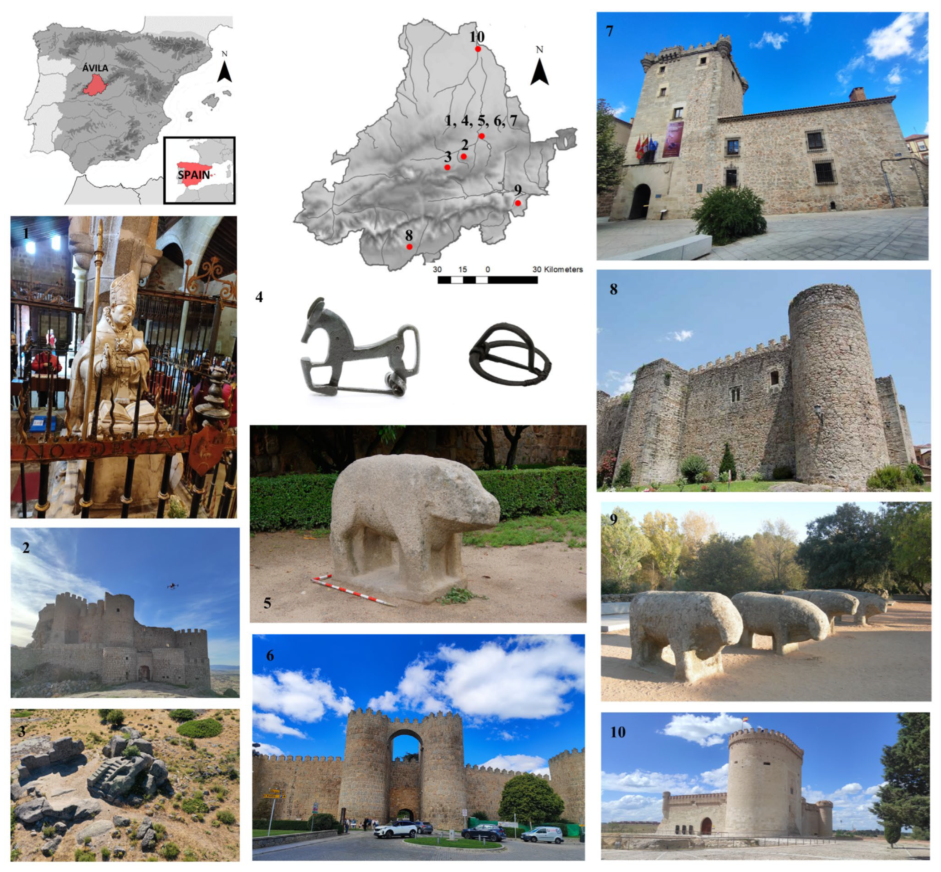
As a result, a diverse set of heritage elements from the province of Ávila was documented, including sculptures, architectural elements, and archeological remains from different scales and periods. The selection included (Figure 2):
-
Figure 2(1): Statue of San Segundo (Hermitage of San Segundo, Ávila). A devotional sculpture located in the Hermitage of San Segundo, dedicated to the patron saint of Ávila. It is one of the most important cult images in the city and a key symbol of local identity (the data was collected on site) [40].
-
Figure 2(2): Aunqueospese Castle (Mironcillo). A 15th-century fortress and one of the best-preserved examples of late medieval military architecture in Ávila. Its keep, walls, and barbican illustrate defensive strategies of the time, and its prominent location makes it a landmark in the provincial landscape (the data was collected on site) [41].
-
Figure 2(3): Ritual Sauna and Rock Sanctuary, Ulaca oppidum (Solosancho). One of the most relevant archeological sites of the Iberian Peninsula during pre-Roman times. The sauna, carved into the rock, is interpreted as a ritual space, while the sanctuary may have been used for sacrifices (the data was collected on site) [42,43].
-
Figure 2(4): Archeological Artifacts from the Museum of Ávila (Ávila). A set of pre-Roman objects, including fibulae, an askos, and ceramic vessels, which are highly valuable for understanding daily life and ritual practices of the Iron Age communities (the data was collected on site) [44,45].
-
Figure 2(5): Verraco from Las Cogotas oppidum (Ávila). A pre-Roman zoomorphic sculpture most likely representing a boar. It has become one of the most recognizable symbols of cultural heritage of the region (the data was collected on site) [46].
-
Figure 2(6): San Vicente Gate, Ávila City Walls (Ávila). One of the main access points to the UNESCO World Heritage-listed city walls. It exemplifies medieval defensive architecture and is among the most iconic landmarks of Ávila (the data collection was carried out on a replica) [47].
-
Figure 2(7): Torreón de los Guzmanes Palace (Ávila). A Renaissance palace that currently houses the Provincial Council of Ávila. Its tower and façade reflect the power and influence of Ávila’s nobility during the 16th century (the data collection was carried out on a replica) [48].
-
Figure 2(8): Arenas de San Pedro Castle (Arenas de San Pedro). Also known as the Castle of Don Álvaro de Luna, this 15th-century fortress preserves cylindrical towers and a strong walled enclosure, making it a fine example of late Gothic military architecture (the data collection was carried out on a replica) [49].
-
Figure 2(9): Guisando Bulls (El Tiemblo). A group of Iron Age zoomorphic sculptures with great historical and symbolic value. The site is also famous as the location of the 1468 Pact of Guisando, a turning point in Castilian history (the data collection was carried out on a replica) [50].
-
Figure 2(10): Arévalo Castle (Arévalo). A medieval fortress later rebuilt under the Catholic Monarchs, notable for its Mudejar brickwork. Today, it houses the Cereal Museum and is one of the most emblematic castles in northern Ávila (the data collection was carried out on a replica) [51].

2.5. Data Acquisition and Processing

The documentation of the selected cultural heritage assets was conducted through a multimethod approach combining terrestrial and aerial photogrammetry, close-range/micro-photogrammetry, and high-resolution structured-light 3D scanning. This strategy ensured adequate coverage of the heterogeneous set of heritage elements involved in the project (from large-scale architectural structures to small archeological artifacts) while exposing students to diverse professional geomatic workflows.
Because one of the core objectives of the project is the production of tactile models for visually impaired users, accessibility considerations directly shaped both the acquisition strategy and the subsequent modeling workflow. Fine-detail artifacts required high-resolution capture (Artec Spider (Artec 3D, Senninger-berg, Luxembourg), micro-photogrammetry) to preserve edges, engravings, and volumetric transitions essential for tactile interpretation. In contrast, large architectural elements were documented prioritizing global geometry and homogeneous surface coverage through UAV photogrammetry. During the 3D editing phase, visually relevant but tactually insignificant micro-details were intentionally removed, while structural transitions were emphasized to improve tactile legibility. This integration of metric documentation with accessibility-oriented simplification constitutes a key methodological contribution of the project. The main instruments and their technical specifications are summarized in Table 1.
Unlike the photogrammetric datasets, which share a common and unified processing workflow, structured-light scanning requires presenting acquisition and processing together because both stages are inherently integrated in the Artec system.

2.5.1. Terrestrial Photogrammetry

For medium-sized objects close-range photogrammetry was employed using DSLR cameras, specifically a Nikon D5600 with an AF-P 18–55 mm lens (Nikon Corporation, Tokyo, Japan), in addition to fixed-focal-length equipment. The Nikon D5600, with its 24.2 MP APS-C sensor and high optical sharpness, provided an optimal balance between portability, resolution, and cost-effectiveness, making it particularly suitable for fieldwork with students.
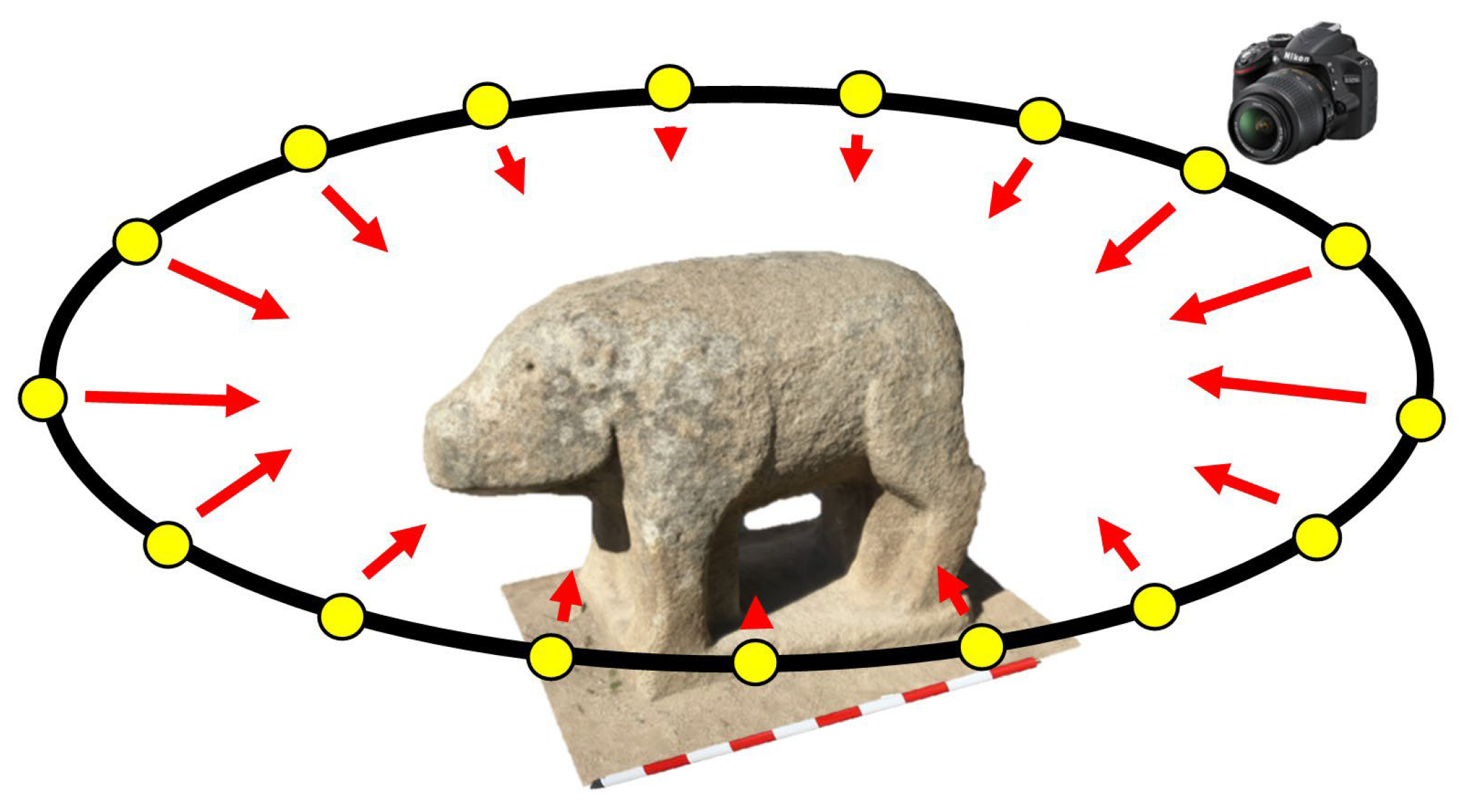
The image acquisition followed structured protocols to ensure data consistency and model accuracy (Figure 3). Shooting sequences were designed in circular and convergent patterns around the object, guaranteeing high overlap between images (80–90%). In addition, all photographs were taken at a consistent distance from the object and, when zoom lenses were used, maintaining the same focal length throughout the sequence. These precautions enhanced the reconstruction of fine details and reduced potential distortions or mismatches in the generated 3D models. These parameters were optimized to produce consistent models with centimeter-level Ground Sampling Distance (GSD), adequate for both research and dissemination purposes [29].
Particular attention was devoted to optimizing illumination conditions during field campaigns to minimize radiometric inconsistencies and artifacts. Whenever possible, stable and diffuse illumination was used to minimize the presence of harsh shadows or overexposed areas, which could negatively affect photogrammetric alignment and texture mapping.
Finally, scale bars, coded targets, and reference markers were placed strategically around the objects. These control points ensured metric reliability, facilitated camera alignment during processing, and allowed the resulting models to be scaled with precision.

2.5.2. Aerial Photogrammetry with UAVs

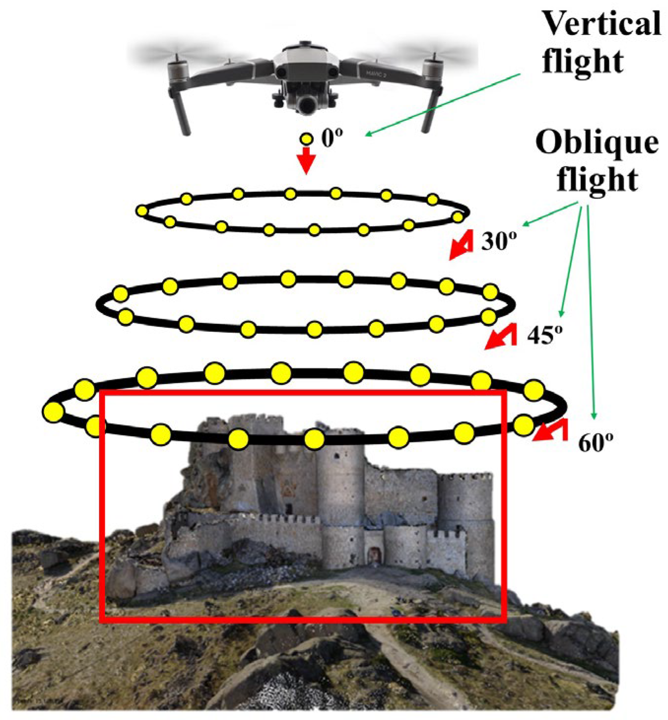
Large heritage elements, such as the castle of Aunqueospese or the ritual sauna and sanctuary of Ulaca, required the use of UAVs equipped with high-resolution RGB sensors for image capture (Figure 4). Specifically, a DJI Mavic 2 Pro (20 MP 1″ CMOS Hasselblad sensor, mechanical shutter) and a DJI Matrice 350 RTK equipped with a Zenmuse P1 camera (20 MP full-frame sensor, RTK positioning accuracy ±0.1 m vertical/±0.3 m horizontal) were used (SZ DJI Technology Co., Ltd., Shenzhen, China). These systems ensured consistent image quality, precise georeferencing, and reliable reconstruction of large architectural structures.
Autonomous flight missions were carefully planned to guarantee systematic coverage of the study areas. Two complementary perspectives were adopted: nadiral flights, providing vertical imagery suitable for orthophoto generation and surface models, and oblique flights, performed at angles of 30°, 45°, and 60° to capture façades, vertical surfaces, and architectural details that would otherwise be poorly represented. The integration of both trajectories allowed for a double-grid acquisition strategy, guaranteeing redundancy and completeness in the dataset.
The photographic acquisition was implemented with high overlaps (80% forward overlap and 70% side overlap) to minimize gaps and guarantee robust photogrammetric reconstruction. These parameters were optimized to produce consistent models with centimeter-level GSD, adequate for both research and dissemination purposes [29].
To improve the quality of the image datasets, data acquisition was scheduled at times when the sun was close to its zenith, thus minimizing the projection of elongated shadows that could interfere with the photogrammetric reconstruction and the quality of the textures. Additionally, a topographic support network was established using both Global Navigation Satellite System (GNSS) receivers and total stations, depending on the conditions of each site. These Ground Control Points (GCPs) were accurately measured and subsequently incorporated into the photogrammetric workflow, ensuring the correct scaling, georeferencing, and overall metric reliability of the generated 3D models.

2.5.3. Micro-Photogrammetry

In the case of very small artifacts where the interpretive value lies in fine reliefs, engravings, or surface textures, micro-photogrammetry was applied. This approach adapts conventional close-range photogrammetry to achieve millimetric or sub-millimetric resolution, enabling the precise capture of delicate morphological details that would otherwise be lost with standard protocols. For this purpose, a Canon EOS 700D equipped with a Canon EF-S 60 mm f/2.8 Macro lens (18 MP APS-C sensor, maximum resolution 5184 × 3456 px) was used (Canon Inc., Ōta-ku, Tokyo, Japan), providing high sharpness and stable close-range performance essential for capturing fine tactile features.
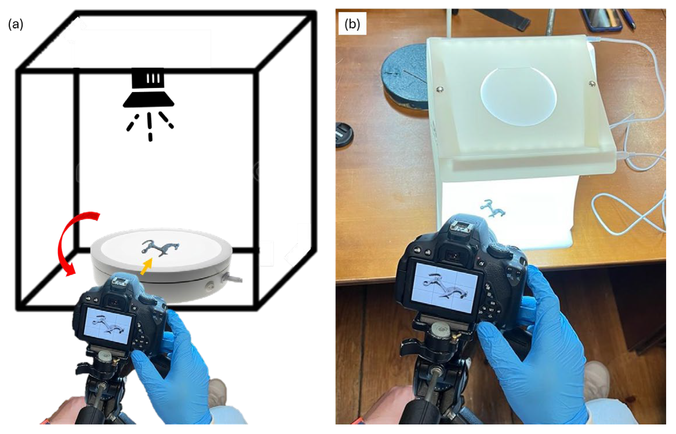
The acquisition setup was carefully designed to ensure stability and control (Figure 5). The camera was mounted on a fixed tripod, maintaining a constant position and focal length throughout the entire sequence. The artifacts were placed on a white rotating turntable, which was itself located inside a white light box that provided diffuse and uniform illumination. This configuration minimized shadows and glare, enhanced image sharpness, and produced homogeneous backgrounds that facilitated the application of digital masks during processing, ensuring that only the artifact was reconstructed while extraneous elements were automatically excluded.
Image capture followed a systematic multi-angle sequence, achieved by rotating the turntable at controlled angular increments to obtain the necessary overlap between images (85–90%). For artifacts with concavities or complex geometries, the object was tilted at different angles, reproducing convergent acquisition strategies to guarantee complete coverage of the surface. The resulting images, characterized by high clarity and contrast, allowed for the generation of dense point clouds and highly detailed 3D models suitable for both analysis and tactile reproduction [44].

2.5.4. Image Processing Workflow with Photogrammetric Software

The images acquired through terrestrial, aerial, and micro-photogrammetric campaigns were subsequently processed using inteGRAted PHOtogrammetric Suite v.2.0.0.beta.8 (GRAPHOS) [52,53], an open-source photogrammetric software developed by the TIDOP (developer of graphos) Research Group (University of Salamanca). GRAPHOS v.2.0.0.beta.8 provides a structured workflow interface that integrates all processing stages (image import, feature extraction and matching, camera calibration and orientation, dense reconstruction, meshing, texturing, scaling, and generation of derivative products) within a single environment. This integrated approach ensured that the reconstruction process was reproducible, transparent, and suitable for both research and dissemination purposes.
The workflow began with image pre-processing and quality control. All datasets were visually inspected to discard blurred, overexposed, or redundant photographs. When required, exposure and color balance were homogenized across the image set to improve subsequent radiometric coherence. For museum artifacts and small-format objects, digital masks were applied to remove the background before processing, effectively isolating the object of interest and preventing the reconstruction of turntables, light-box walls, or other unwanted elements. During this phase, the GRAPHOS v.2.0.0.beta.8 Console was systematically monitored to verify that processes were running correctly and to detect potential warnings, while the Properties panel was used to examine image metadata such as focal length, aperture, and resolution prior to calibration.
The next stage involved feature extraction and robust matching. GRAPHOS v.2.0.0.beta.8 employs a SIFT-based algorithm to detect scale- and rotation-invariant key points, followed by a matching procedure that includes ratio tests, cross-check validation, and geometric filtering through RANSAC applied to the fundamental, homography, and essential matrices. When UAV imagery contained GNSS metadata, the Spatial Matching function was activated to restrict pairwise matching to spatially adjacent images, thereby reducing computation time and improving the reliability of the matches.
Following feature detection and matching, the Structure-from-Motion (SfM) process was applied. SfM is a computer vision technique that simultaneously solves for the intrinsic camera parameters and the external orientation of each image while reconstructing a sparse three-dimensional representation of the scene. This step resulted in the estimation of camera positions and orientations in a common reference frame and the generation of a sparse point cloud. The sparse reconstruction was visually inspected to ensure proper coverage and geometric consistency before advancing to dense reconstruction.
The dense point cloud was then generated using Multi-View Stereo (MVS) algorithms, with alternative implementations such as CMVS/PMVS or SMVS employed when required by the geometry or scale of the object. Reconstruction parameters (including quality level, number of contributing images, and minimum number of views for depth-map fusion) were optimized to balance geometric precision with computational efficiency. From this point cloud, a triangular mesh was computed using surface reconstruction techniques, providing a continuous geometric representation of the object. Mesh optimization operations were applied conservatively to avoid compromising morphological fidelity, particularly in heritage elements with archeological or sculptural relevance.
High-resolution texture mapping was subsequently performed by projecting the original photographs onto the mesh. Radiometric corrections, including histogram equalization and color balancing, were applied to enhance visual uniformity and to highlight fine surface details. This was particularly relevant for engraved or decorated artifacts, where surface texture contributes to their interpretive value.
Once obtained the complete and visually coherent model, it was scaled and georeferenced using GCPs or reference distances measured during fieldwork. GRAPHOS v.2.0.0.beta.8 enables absolute orientation through the definition of a Cartesian reference system, converting the relative model into a metric reconstruction suitable for quantitative analysis, comparison with other datasets, and integration into Geographic Information Systems (GIS). Residual errors were systematically analyzed to verify that the resulting models achieved centimeter-level accuracy for architectural structures and sub-millimetric accuracy for small artifacts.
Finally, the validated models and associated products were exported in standard formats (e.g., OBJ, PLY, STL), preserving both geometric and radiometric information. These outputs were then integrated into interactive platforms, used for immersive visualization, and, where appropriate, prepared for 3D printing to enable tactile dissemination and physical reproduction of the documented heritage elements.

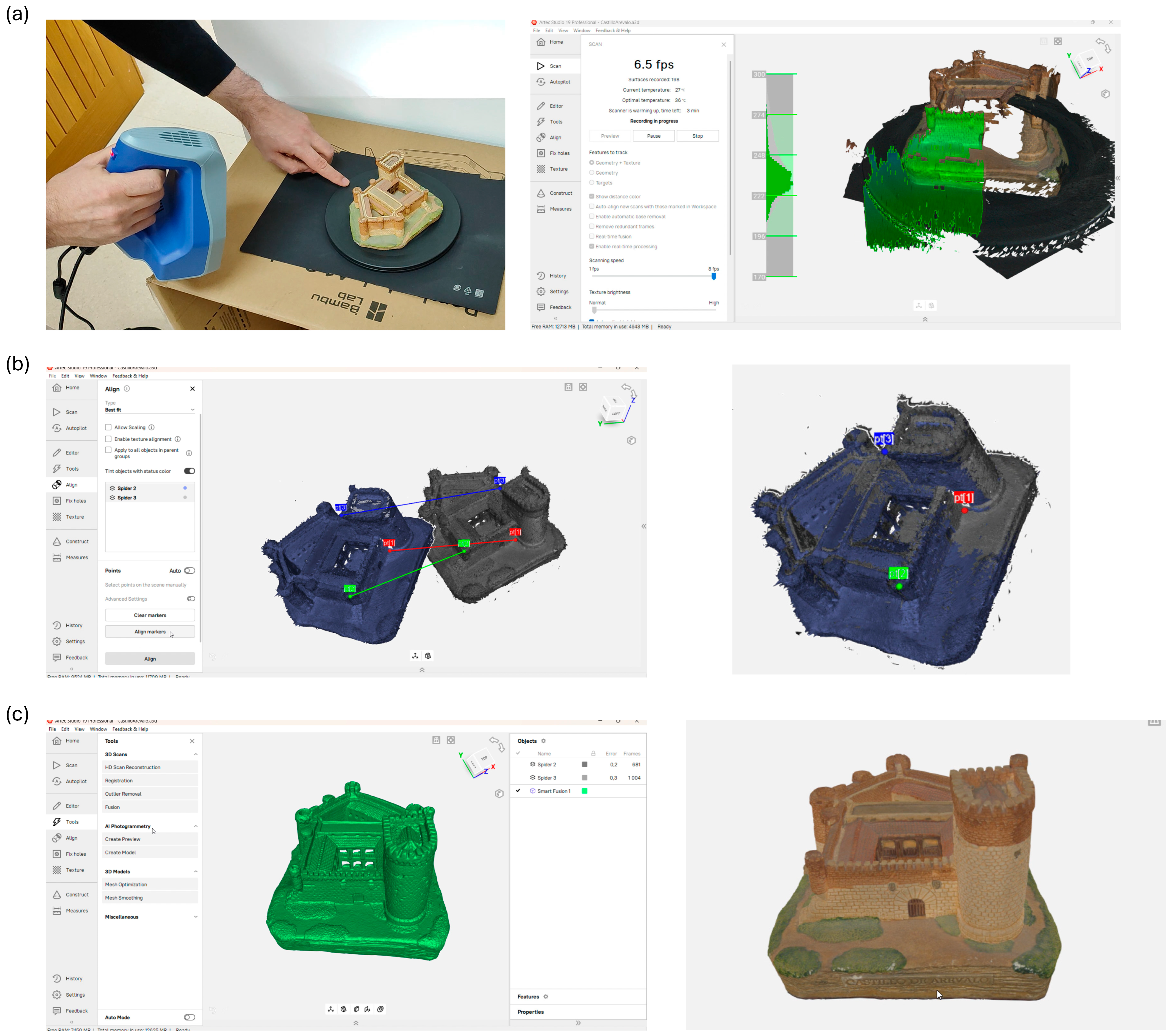
2.5.5. High-Resolution 3D Scanning

High-resolution 3D scanning was performed using two complementary structured-light devices: the Artec Eva scanner (Artec 3D, Senningerberg, Luxembourg), optimized for medium-sized objects such as sculptural elements or architectural fragments, and the Artec Spider scanner (Artec 3D, Senningerberg, Luxembourg), designed for small artifacts where high-resolution detail and sharp edge preservation were essential. The use of both scanners provided a flexible solution capable of adapting to the wide range of object scales and morphological complexities documented during the project.
The scanning workflow began with the preparation of the object and scanning environment (Figure 6). Artifacts were positioned on neutral, non-reflective supports and surrounded by a controlled workspace with minimal background interference. Diffuse and stable lighting conditions were maintained to avoid specular highlights that could degrade the quality of the captured frames.
During data acquisition, the scanner was moved smoothly around each object, maintaining a constant distance to ensure optimal focus and uniform surface resolution. Whenever possible, a rotating turntable was used to simplify the process: the object was rotated incrementally while the scanner remained fixed, ensuring uniform coverage and minimizing operator-induced variability. The Artec Eva (Artec 3D, Senningerberg, Luxembourg) was employed primarily for larger elements, leveraging its wide field of view and high capture speed to efficiently document objects up to approximately one meter in size. The Artec Spider (Artec 3D, Senningerberg, Luxembourg), with its higher resolution and smaller field of view, was used for intricate artifacts, engraved surfaces, and fine decorative details. Throughout the process, the real-time feedback interface of Artec Studio v.19.2.4.8 was continuously monitored to guarantee complete surface coverage, and multiple acquisition passes from different angles were performed to eliminate occlusions and capture undercuts or concave geometries.
Post-processing was conducted in Artec Studio v.19.2.4.8, following a reproducible sequence of steps. Global Registration was first applied to align all the individual frames and passes into a unified reference system using a robust Iterative Closest Point (ICP) algorithm. This step guaranteed precise overlap between datasets acquired from different angles. When reference distances or calibrated scale bars were available, they were incorporated at this stage to ensure rigorous metric consistency across the reconstructed models.
The registered data were then merged using Sharp Fusion, an algorithm that produces a watertight mesh while preserving edge definition and fine geometric features—an essential requirement for archeological and sculptural heritage objects. Mesh cleaning was implemented to remove noise and outliers, while mesh decimation was applied only where necessary to reduce file size for dissemination without compromising morphological fidelity.
When surface color was relevant, texture mapping was performed using the color frames captured during scanning. Artec Studio’s UV mapping tools projected the radiometric information onto the polygonal mesh, generating high-quality, photorealistic textures. Color equalization was applied across different passes to maintain uniformity and avoid visible seams. In cases where the primary objective was metric analysis, non-textured meshes were preferred to emphasize geometry over appearance.
Once processed, the resulting models were exported in standard formats (OBJ, PLY, STL) directly from Artec Studio v.19.2.4.8. These models, already scaled by the scanner’s internal calibration, were ready for seamless integration with photogrammetric datasets, digital archiving, visualization in virtual museum platforms, and preparation for 3D printing to create tactile replicas for educational, dissemination, and conservation purposes.

2.5.6. Accessibility Guidelines

Accessibility was a guiding principle throughout the project, with the aim of ensuring that the resulting models could be meaningfully explored by people with visual impairments. The work followed the recommendations of the reference document “Technical Accessibility Criteria for Cultural and Natural Heritage for People with Visual Impairments” [39], which establishes best practices for tactile interpretation of cultural and natural heritage. This manual provided criteria for the selection of heritage assets suitable for tactile reproduction, geometric simplification principles without loss of cultural meaning, differentiated texturing to represent distinct materials, ergonomic scaling to allow comfortable manual exploration, and the systematic incorporation of Braille labeling to enable autonomous interaction.
Once the 3D models were generated through photogrammetry or structured-light scanning, they were imported into Blender v.4.2. for a detailed accessibility-oriented editing workflow. Operations included geometry simplification to remove elements too small or fragile to be meaningfully perceived through touch, rounding of sharp edges to avoid injury during tactile exploration, and layer separation and extrusion to make roofs, entrances, or functional zones more distinguishable.
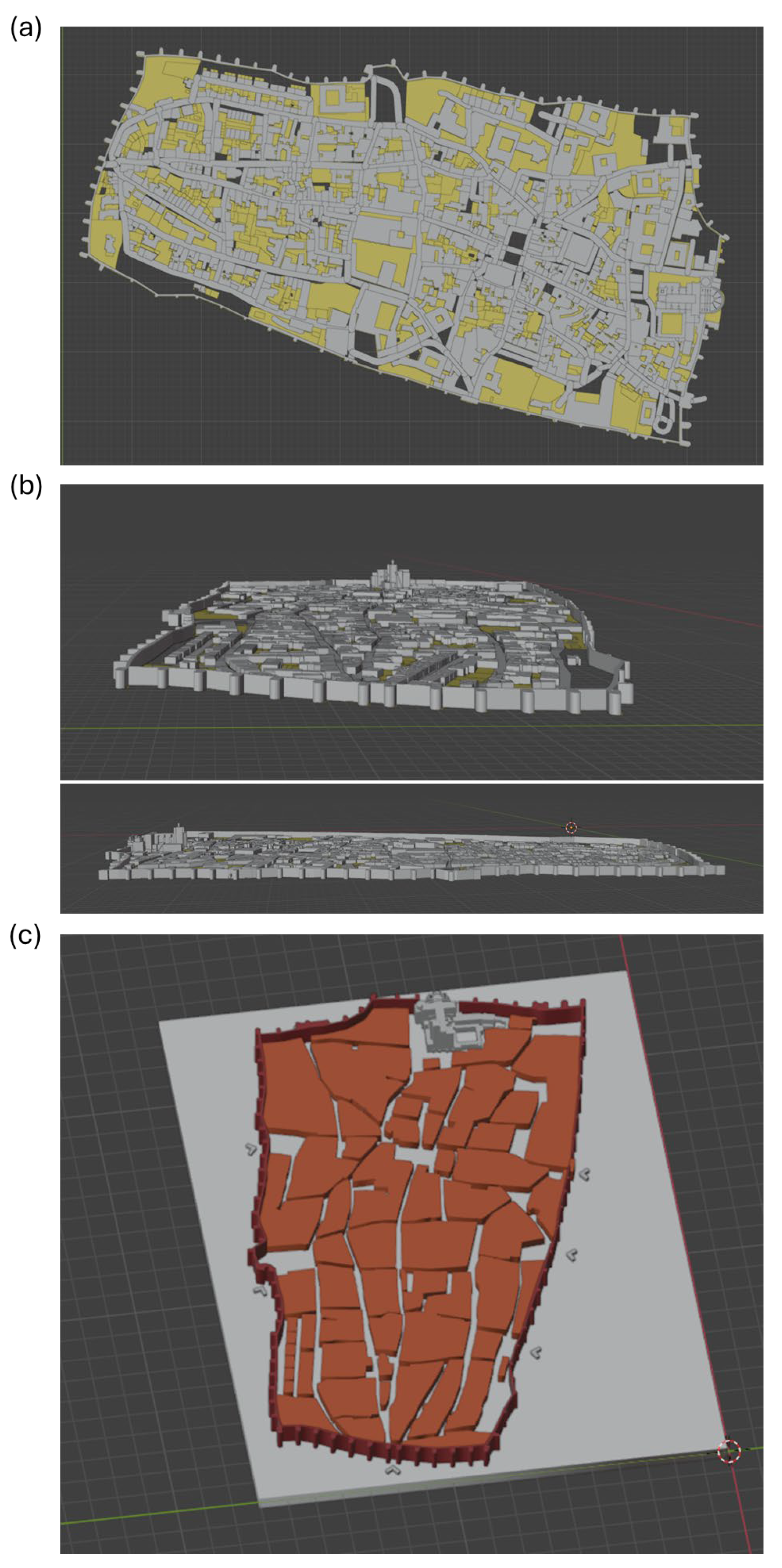
In addition to the 3D models of the documented cultural heritage assets, a 3D tactile map of the historic city of Ávila was created (Figure 7). This model was developed in Blender v.4.2. as an accessibility resource, allowing users to understand the spatial organization of the walled city before interacting with the individual artifacts. The process involved acquiring cadastral vector data, importing and aligning it in Blender v.4.2., and integrating it with simplified 3D building models derived from OpenStreetMap. The models were then extruded at differentiated heights to establish a clear hierarchy between monumental buildings, residential structures, and public spaces. Additional tactile cues (such as raised arrows) were added to indicate the location and orientation of the main gates of the medieval walls, enhancing spatial comprehension and navigation for users.
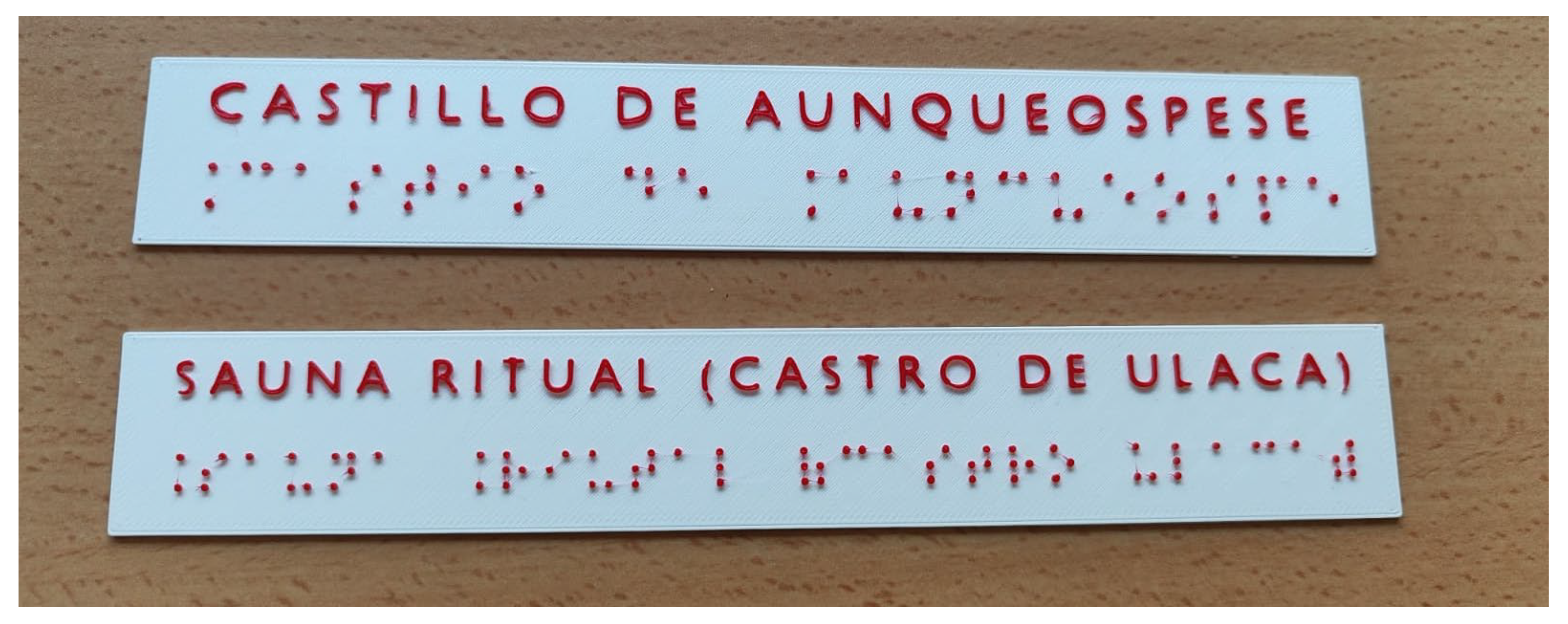
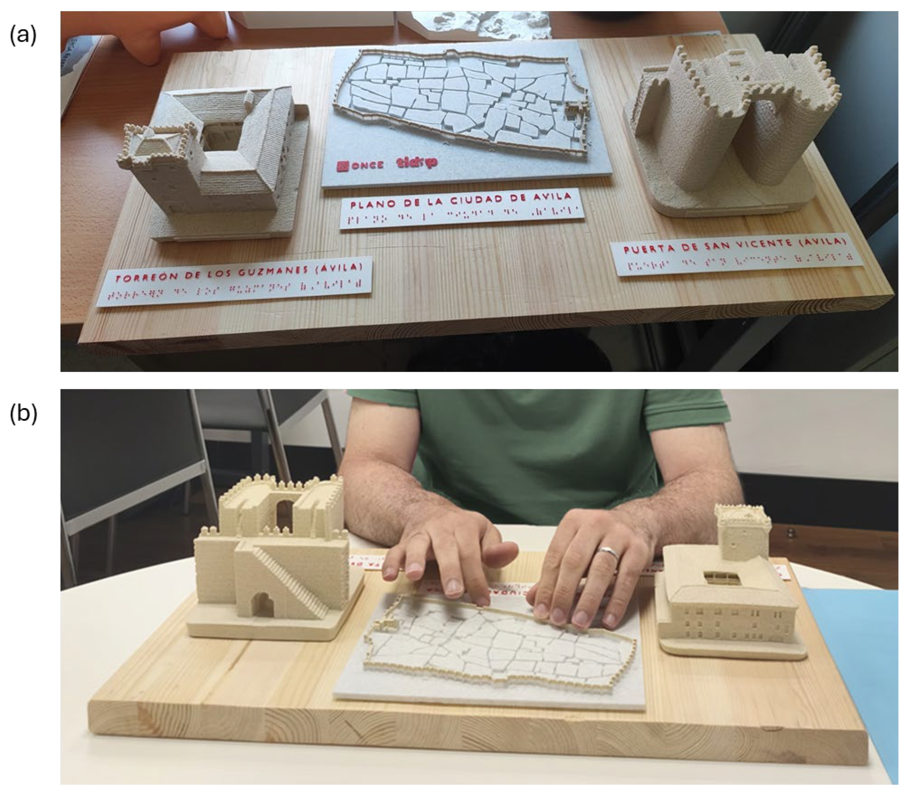
In parallel, Braille information plaques were designed in Blender v.4.2., combining raised text with its Braille transcription (Figure 8). These plaques were printed in two contrasting colors (red text on a white background) to improve legibility for users with partial sight. This solution allowed an inclusive experience, supporting both tactile and visual recognition. All models and plaques were mounted on wooden bases, improving stability and offering a coherent, thematic presentation (Figure 9a).
The models were subsequently fabricated using additive manufacturing techniques and evaluated in validation workshops conducted in collaboration with ONCE Ávila (Figure 9b). During these sessions, participants with visual impairments explored the replicas and provided feedback regarding spatial comprehension, tactile comfort, and Braille readability. This input was incorporated into iterative refinements, including adjusting scales, simplifying overly complex geometries, and adding additional tactile reference points.
The combination of tactile models, Braille signage, urban maps, and accessible textures demonstrates a commitment to universal design principles, offering an inclusive way to access cultural heritage. Beyond its technical contribution, the project served an educational and social function, raising awareness among students about the importance of accessibility in heritage interpretation and empowering users with visual disabilities to interact autonomously with their cultural environment.

2.5.7. Student Survey

To systematically assess the educational dimension of the project, a paper-based student survey was designed and administered at the conclusion of the activity. The aim was to gather structured and quantifiable feedback regarding students’ perceptions of the methodology and the learning experience. The questionnaire consisted exclusively of closed-ended questions formulated on a five-point Likert scale (1 = strongly disagree, 5 = strongly agree), allowing for objective statistical treatment of the responses.
The survey was organized into four sections. The first section, Technical Skills, focused on evaluating students’ self-perceived improvement in operating DSLR cameras, planning UAV photogrammetric flights, using 3D scanning equipment (Artec Eva and Artec Spider (Artec 3D, Senningerberg, Luxembourg)), and processing data with GRAPHOS v.2.0.0.beta.8, Artec Studio v.19.2.4.8, and Blender v.4.2. The second section, Learning Experience, assessed the clarity of instructions, the organization and scheduling of fieldwork and laboratory sessions, and the perceived level of difficulty of the tasks. The third section, Heritage Awareness, explored students’ understanding of cultural heritage documentation, its relevance for conservation, and the importance of accessibility measures such as tactile models and Braille signage. Finally, the fourth section, General Satisfaction, measured overall impressions of the activity and the students’ willingness to recommend it for future cohorts.
This structured and standardized approach provided a robust methodological framework for collecting comparable data, enabling a reliable evaluation of the project’s educational effectiveness and its contribution to students’ professional training.
The complete questionnaire used in this survey, including all closed-ended questions and the response scale, is provided as Supplementary Materials File to allow replication of the methodology and facilitate comparison with future educational initiatives.

3. Results

In addition to the educational outcomes presented below, the technical results of the 3D documentation process confirm that the expected accuracy levels were successfully achieved. Aerial and terrestrial photogrammetry produced models with centimetric precision, while micro-photogrammetry and structured-light 3D scanning yielded sub-millimetric accuracy. All reconstructed meshes show high geometric fidelity, with well-defined surfaces, sharp edges, and complete coverage of both small artifacts and large architectural structures. Once the technical performance of the workflow was validated, the analysis then focused on the educational impact of the project. Twelve students completed the questionnaire, yielding a global average of 4.2/5, which indicates a consistently satisfactory appraisal of the PATCULT 3D experience across its technical, pedagogical, and social dimensions.
The following Table 2 presents a condensed subset of the Likert-scale items used in the student survey conducted as part of the PATCULT 3D evaluation. This selection summarizes the most representative indicators of technical learning, workflow comprehension, accessibility awareness, and overall satisfaction. The complete questionnaire (including all individual items, grouped dimensions, and full response distributions) is provided in the Supplementary Materials File to ensure methodological transparency and allow replication in future educational studies. The purpose of including this subset here is to illustrate the structure and thematic scope of the survey instrument, while the full dataset remains available in the Supplementary Materials File.
Each item corresponds to one of the main evaluation dimensions (technical skills, workflow comprehension, accessibility awareness, or general satisfaction). Mean and standard deviation (SD) values are displayed. Full questionnaire and all response distributions are provided in the Supplementary Materials File.
An internal consistency analysis showed good reliability for the survey instrument (Cronbach’s α = 0.82), supporting the coherence and robustness of the Likert-scale responses across the different evaluation dimensions.
In relation to the technical growth, students reported robust competence gains along the full acquisition–processing–publication chain. For DSLR handling and structured image acquisition protocols for photogrammetry, 83.3% selected 4–5 (33.3% “agree”, 50.0% “strongly agree”). Confidence in planning UAV missions and understanding regulations/protocols also scored highly, with 75.0% at 4–5. Photogrammetric data processing reached 83.3% at 4–5, and operation of structured-light scanners (Artec Eva and Artec Spider (Artec 3D, Senningerberg, Luxembourg)) reached 75.0% at 4–5. Work with point clouds and 3D models was similarly strong (83.3% at 4–5), and Blender-based optimization/editing achieved 91.7% at 4–5. These results align with field and lab observations: students progressed from protocolized image capture (nadir/oblique UAV flights, circular convergent terrestrial captures, and micro-photogrammetry setups) and controlled 3D scanning sessions to high-fidelity reconstructions and mesh refinement suitable for dissemination and fabrication.
Perceptions of the learning experience were equally satisfactory. 91.7% agreed that instructions in fieldwork and lab sessions were clear and easy to follow, and 83.3% found the difficulty level appropriate and stimulating. The integration of photogrammetry with 3D scanning was widely considered engaging and innovative (83.3% at 4–5). Time management was well rated, with 83.3% agreeing that the allocation per task allowed successful completion. Moreover, 75% of the students indicated that applying the knowledge acquired to practical cases helped them consolidate and deepen their understanding, highlighting the effectiveness of the hands-on approach in reinforcing learning outcomes. Two aspects highlight the authenticity of the training context: the use of professional tools that closely simulated a real working environment (91.7% rated 4–5), and teamwork dynamics that promoted idea exchange and collaborative learning (83.3% rated 4–5). Moreover, 91.7% of participants reported that the activity helped them identify new areas of interest for further skill development, suggesting that the project not only strengthened existing competences but also opened meaningful avenues for specialization (e.g., UAV planning, mesh decimation for fabrication, accessible model design).
In terms of heritage awareness, the project significantly improved understanding of documentation as both a conservation strategy and a vehicle for social dissemination. 75.0% agreed that the activity increased awareness of cultural heritage documentation; 91.7% better understood the importance of 3D documentation for preservation. Accessibility-focused items (central to PATCULT 3D) also scored high: 83.4% agreed that attention to Braille signage and tactile models enhanced appreciation of the social value of heritage. Items concerning digitization as a preventive conservation tool and the role of documentation and virtual reconstruction in intergenerational transmission showed more variability (with 25.0% selecting 5 in each case and a meaningful share at 4) but still maintained a satisfactory majority at 4–5, which is coherent with students’ prior exposure and the conceptual complexity of these topics. Moreover, 83.3% of the students indicated that the experience enhanced their awareness of the need to protect and share heritage from an inclusive perspective, underscoring the project’s social and educational impact on fostering inclusive cultural values. Importantly, 75.0% recognized the relevance of combining technological innovation with respect for the historical and cultural value of heritage assets, reinforcing the ethical frame within which the technical work was conducted.
General satisfaction was very high. 91.7% agreed they were satisfied overall, 83.3% would recommend the activity to future students, and 75.0% valued the application of knowledge in real-world contexts. Additionally, 83.3% of the students reported that the activity met their expectations and learning objectives, indicating a robust alignment between the project’s pedagogical design and the participants’ academic development goals. Motivation and engagement remained strong throughout the workflow (75.0%), and the combination of theory and practice received 91.7% satisfactory ratings. Furthermore, 91.7% of the students indicated that the experience helped them acquire skills useful both academically and professionally, confirming the project’s high effectiveness in fostering transferable and career-relevant competencies. Willingness to repeat similar activities was also high (91.7% at 4–5), underscoring the perceived relevance of the experience for both academic progress and employability.
A salient outcome of PATCULT 3D was the design, fabrication, and validation of tactile models that operationalize accessibility principles. Students produced high-readability 3D prints of selected heritage assets (architectural elements, sculptures, and small archeological artifacts), integrating Braille plaques and adopting universal design criteria (geometry simplification without loss of meaning, edge rounding for safe haptics, differentiated textures for material legibility, ergonomic scaling, and clear orientation cues). These models (together with a tactile map of the historic city of Ávila) were presented in validation workshops organized in collaboration with ONCE Ávila. Feedback from ONCE specialists and visually impaired participants confirmed the functional validity of the replicas and their effectiveness as tools for tactile exploration and inclusive interpretative engagement. The sessions yielded concrete refinements: adjusting model scales to improve hand coverage, emphasizing thresholds and salient reliefs, clarifying roof–wall transitions, and optimizing the placement and contrast of Braille labels. This external validation closes the loop between academic production and social applicability; it demonstrates that students not only mastered advanced geomatic workflows but also delivered functionally accessible outputs that meet real user needs.
During the validation workshops, nine visually impaired participants and two ONCE technicians provided substantive and methodologically oriented feedback on the tactile replicas. Most users requested small scale adjustments to enhance object handling and interpretation, and several participants highlighted the need to accentuate certain relief transitions so that key architectural forms could be distinguished more easily through touch. A few users also suggested incorporating additional tactile reference points to improve spatial orientation across the models. Braille readability was consistently well received, and all participants confirmed that the labels were clear and easy to interpret. These observations complement the qualitative feedback gathered during the sessions and confirm the functional accessibility of the tactile replicas.

4. Discussion

The results of the PATCULT 3D project confirm that combining advanced geomatic techniques with a service-learning (SL) framework can achieve a twofold impact: enhancing students’ technical competences while simultaneously generating social value through accessible cultural heritage resources [20]. The consistently high ratings across the survey (global average 4.2/5) demonstrate that students not only acquired solid technical skills but also internalized the broader social responsibility associated with cultural heritage documentation. This dual benefit resonates with previous studies on SL in higher education, which underline its capacity to align disciplinary training with civic engagement and community impact [15].
From the technical perspective, the survey data illustrate a clear trajectory of learning: students progressed from DSLR-based photogrammetry and UAV mission planning to structured-light scanning, dense reconstruction, and Blender-based optimization for fabrication. The high percentage of responses in the 4–5 range (typically above 80%) in items related to these skills, indicates that participants perceived substantial competence gains. These outcomes suggest that the integration of authentic workflows (mirroring professional practices in photogrammetry, 3D scanning, and additive manufacturing) provides students with learning opportunities that are both relevant and transferable to professional contexts [21]. The validation of this perception is further reinforced by the tangible outputs of the project: accurate digital models and physical replicas that required mastering the entire acquisition-to-fabrication pipeline.
Also important is the project’s contribution to students’ awareness of heritage and accessibility. While technical mastery was an explicit goal, the incorporation of accessibility principles (Braille signage, tactile maps, and tactile models) provided a unique framework through which students could reflect on the societal implications of their work [54]. The survey results confirm that this dimension was recognized and valued: the majority of students agreed that accessibility considerations enhanced their appreciation of the social role of heritage documentation. Interestingly, the items related to digitization as a preventive conservation tool and as a means of intergenerational transmission showed more variability, with a larger share of neutral responses. This may reflect the abstract nature of these concepts compared to the more tangible experience of producing and testing tactile replicas. Nonetheless, even in these more complex items, the prevailing trend remained satisfactory, suggesting that the project successfully planted the seeds for deeper critical reflection.
In addition, the validation of the tactile models by ONCE Ávila represents one of the most significant achievements of the project. External assessment by professionals and visually impaired users confirmed that the replicas were not only technically accurate but also functionally accessible, meeting the criteria for haptic exploration and inclusive interpretation [55]. This validation process elevated the project from an academic exercise to a socially meaningful contribution, demonstrating the potential of higher education institutions to co-create resources with community stakeholders. Moreover, the iterative refinement of models based on user feedback exposed students to the realities of participatory design, where technical decisions must be balanced with ergonomic, perceptual, and cultural considerations. This experience exemplifies how SL can embed empathy, critical thinking, and communication skills within technical curricula, complementing purely cognitive learning outcomes.
The broader implications of PATCULT 3D also extend to debates on the role of digital technologies in heritage conservation. While digitization has long been advocated as a preventive strategy against deterioration, neglect, or destruction, this project illustrates that its relevance goes beyond conservation: it becomes a vehicle for accessibility and inclusion [56]. By producing tactile replicas, students not only preserved heritage digitally but also enabled new audiences to interact with it physically, thereby broadening its social significance. This dual role of digital documentation (as both a protective and a democratizing tool) underscores its importance in contemporary heritage management, particularly when integrated with universal design principles.
Finally, the outcomes of PATCULT 3D can be included within the framework of the Sustainable Development Goals. By strengthening technical education (SDG 4), fostering innovation in digital workflows (SDG 9), reducing inequalities through accessible heritage products (SDG 10), and promoting sustainable and inclusive cultural communities (SDG 11), the project demonstrates how academic initiatives can contribute directly to global agendas. The alignment of student training with societal challenges represents a compelling model for higher education institutions seeking to balance academic excellence with civic relevance [57].
Despite these satisfactory outcomes, several limitations should be acknowledged. First, the sample size was modest (12 students), which, while sufficient to provide representative feedback in this context, limits the generalizability of the results. Second, the range of heritage assets documented, though diverse, was restricted to the province of Ávila and to objects with specific tactile suitability; future projects should expand to broader typologies, scales, and cultural contexts to test the robustness of the methodology. Third, the accessibility framework was largely limited to tactile models and Braille signage; while effective, this scope could be extended through integration with immersive technologies (e.g., virtual reality, augmented reality, or multimodal interfaces) to enrich accessibility for different user profiles. Finally, while validation with ONCE Ávila was a critical step, further longitudinal studies involving repeated use by visually impaired audiences would provide deeper insights into the durability, usability, and educational impact of the replicas.
The study design presents inherent limitations, particularly the absence of a pre/post assessment or comparison group. This was due to the small cohort (n = 12) and the heterogeneous academic levels of participants, which made the formation of equivalent groups unfeasible without disrupting curricular progression. Future editions of the project, with larger and more homogeneous groups, will incorporate pre/post evaluations and, when possible, quasi-experimental designs to strengthen the measurement of learning gains and accessibility awareness.
Although this pilot implementation provides valuable insights into the integration of geomatics training and accessibility-oriented service-learning, its conclusions must be interpreted within the limited scope of the project, characterized by a small and heterogeneous cohort (n = 12). Future iterations with larger samples and replication in other academic contexts will be essential to validate the generalizability of the educational model.
Compared with previous accessibility-oriented heritage education initiatives [58,59,60], the PATCULT 3D project introduces a distinct methodological contribution. Its novelty lies not in individual technologies but in their systematic integration within a service-learning framework that combines: (i) a complete acquisition–processing–fabrication pipeline embedded across a geomatics curriculum; (ii) a standardized accessibility-oriented 3D editing workflow in Blender v.4.2. based on official guidelines; (iii) formal co-design and validation with ONCE; and (iv) quantitative assessment of both educational and social impact. This methodological articulation distinguishes the project from previously documented case studies and provides a reproducible model for accessibility-driven digital heritage education.
Beyond the immediate educational and technical outcomes, the 3D models generated within the PATCULT 3D project will be further applied in two ongoing research initiatives that aim to revitalize territories affected by demographic decline through the valorization of their cultural heritage. These projects seek to integrate technological innovation, heritage conservation, and community participation as drivers of sustainable regional development. In this broader context, the present work demonstrates how academic initiatives can transcend the classroom to contribute directly to social innovation and territorial cohesion. Moreover, by engaging students in research processes (from data acquisition to practical application) it provides them with firsthand experience of how scientific inquiry operates within real-world challenges, reinforcing the link between education, research, and societal impact. This work has been funded by the Spanish Ministry of Science, Innovation and Universities (MCIN/AEI) through the “NextGenerationEU”/PRTR program of the European Union (CNS2023-144126), and by the Regional Government of Castile and León (Junta de Castilla y León) through project SA080P24, within the framework of the 2021–2027 ERDF Operational Programme.
Future lines of work should therefore focus on scaling up the initiative both quantitatively and qualitatively: involving larger student cohorts across multiple institutions, diversifying case studies to include intangible heritage and natural landscapes, and integrating cross-disciplinary collaborations (e.g., with education, psychology, and social sciences) to assess the holistic impact of accessibility-oriented digital heritage projects. Technological innovation could be expanded through the incorporation of IoT-based monitoring, AI-driven mesh optimization, and real-time interactive platforms to complement tactile exploration. At the same time, pedagogical strategies could further explore the transformative potential of service-learning by fostering stronger links between technical competences, civic responsibility, and community engagement.
In this regard, PATCULT 3D not only illustrates a successful integration of digital geomatics and social inclusion but also sets the stage for a broader research agenda where heritage documentation becomes an active catalyst for sustainable development, equity, and participatory cultural experiences.

5. Conclusions

The PATCULT 3D project demonstrates the potential of integrating advanced digital geomatic techniques with service-learning pedagogies to achieve a double impact: strengthening students’ technical training while simultaneously producing tangible social benefits. Through a multimethod documentation strategy (including terrestrial and aerial photogrammetry, micro-photogrammetry, structured-light 3D scanning, and digital model optimization) the project provided students with hands-on experience that closely mirrored professional practice. The consistently high levels of satisfaction expressed in the survey (global average 4.2/5) confirm that participants perceived the initiative as both academically rigorous and highly relevant to their future careers.
Beyond technical competence, the project contributed significantly to raising heritage awareness and social responsibility among students. By embedding accessibility as a core principle (through the design of tactile models, Braille signage, and a tactile map of Ávila) participants came to recognize cultural heritage not only as a technical or academic subject but also as a resource to be shared inclusively with society. The validation of the replicas by ONCE Ávila represents a decisive step in ensuring that these outputs are not merely academic prototypes but usable, socially valuable tools for the visually impaired community.
The experience also illustrates how higher education can contribute to the Sustainable Development Goals, particularly SDG 4 (Quality Education), SDG 9 (Industry, Innovation, and Infrastructure), SDG 10 (Reduced Inequalities), and SDG 11 (Sustainable Cities and Communities). By aligning student learning with real social challenges, PATCULT 3D shows that universities can act as drivers of innovation and inclusion, reinforcing the cultural and civic dimensions of education.
In conclusion, PATCULT 3Dexemplifies the effective convergence of digital heritage documentation, accessibility-driven design, and higher-education training within a unified and socially responsive framework. The project not only succeeded in equipping students with advanced technical competences but also instilled in them a sense of empathy, responsibility, and commitment to cultural sustainability. Future initiatives that build on this model (expanding to larger cohorts, more diverse case studies, and multimodal accessibility strategies) hold great promise for reinforcing the link between geomatics, heritage conservation, and inclusive education.

Supplementary Materials

The following supporting information can be downloaded at: https://www.mdpi.com/article/10.3390/app152312425/s1, Survey S1: Questionnaire used for data collection.

Author Contributions

Conceptualization, M.Á.M.-G., E.G.G. and J.R.-H.; methodology, M.Á.M.-G. and C.S.B.; software, M.Á.M.-G.; validation, M.Á.M.-G., E.G.G. and C.S.B.; formal analysis, M.Á.M.-G.; investigation, M.Á.M.-G., F.P.F., P.A.-A., S.D.-d.l.F. and B.A.-P.; resources, M.Á.M.-G.; data curation, M.Á.M.-G. and C.S.B.; writing—original draft preparation, M.Á.M.-G.; writing—review and editing, M.Á.M.-G., E.G.G., C.S.B. and J.R.-H.; visualization, M.Á.M.-G.; supervision, M.Á.M.-G. and S.L.-C.M.; project administration, M.Á.M.-G.; funding acquisition, M.Á.M.-G. and E.G.G. All authors have read and agreed to the published version of the manuscript.

Funding

This project was primarily supported by the II Call for Service-Learning Projects of the University of Salamanca (Project ID ApS2024/01), coordinated by the Servicio de Asuntos Sociales during the 2024–2025 academic year. Additional financial support was provided by the Spanish Ministry of Science, Innovation and Universities and the State Research Agency (Agencia Estatal de Investigación, AEI) through grants from the European Union “NextGenerationEU”/PRTR (RF.CNS2023-144126), and by the Junta Castilla y Léon (SA080P24).

Institutional Review Board Statement

Not applicable.

Informed Consent Statement

Informed consent was obtained from all subjects involved in the study.

Data Availability Statement

The original contributions presented in the study are included in the article/supplementary material, further inquiries can be directed to the corresponding author.

Acknowledgments

M.Á. Maté-González and C. Sáez Blázquez acknowledge grants RYC2021-034813-I and RYC2021-034720-I, respectively, funded by MCIN/AEI/10.13039/501100011033 and by the European Union “NextGenerationEU”/PRTR. We would like to thank the Museum of Ávila for providing access to the archeological artifacts. The authors would like to express their sincere gratitude to María Dolores Pascua Hernández, from the Servicio de Asuntos Sociales of the University of Salamanca, for coordinating the service-learning initiative PATCULT 3D—Cultural Heritage in 3D: Exploration, Preservation and Accessibility through Service-Learning in Geomatics, developed in collaboration with Fundación ONCE (Project ID ApS2024/01), and approved under the II Call for Service-Learning Projects for the 2024–2025 academic year. Special thanks are also extended to Josep Murgui Usach from the Organización Nacional de Ciegos Españoles (ONCE) de Ávila for his collaboration, guidance, and participation in the validation of tactile models. The authors further acknowledge the support of the Higher Polytechnic School of Ávila (University of Salamanca) for providing the facilities and resources that made this project possible.

Conflicts of Interest

The authors declare no conflict of interest.

References

  1. Li, H.; Ikebe, K.; Kinoshita, T.; Chen, J.; Su, D.; Xie, J. How heritage promotes social cohesion: An urban survey from Nara city, Japan. Cities 2024, 149, 104985. [Google Scholar] [CrossRef]
  2. Richardson, M.; Butler, C.W.; Alcock, I.; Tindley, A.; Sheffield, D.; White, P.C. Introducing heritage connectedness: Connections to people, nature and place across time are associated with wellbeing and environmentalism. Hist. Environ. Policy Pract. 2025, 16, 38–58. [Google Scholar] [CrossRef]
  3. Naheed, S.; Shooshtarian, S. The role of cultural heritage in promoting urban sustainability: A brief review. Land 2022, 11, 1508. [Google Scholar] [CrossRef]
  4. Maté-González, M.Á.; Sáez Blázquez, C.; Gutiérrez-Martín, N.; Lorenzo Canales, M. Evaluation of the Emotional Impacts of the Notre Dame Cathedral Fire and Restoration on a Population Sample. Heritage 2025, 8, 226. [Google Scholar] [CrossRef]
  5. Chen, W. Social cohesion from urban heritage. Nat. Cities 2024, 1, 496. [Google Scholar] [CrossRef]
  6. Mastrogiuseppe, M.; Span, S.; Bortolotti, E. Improving accessibility to cultural heritage for people with intellectual disabilities: A tool for observing the obstacles and facilitators for the access to knowledge. ALTER Eur. J. Disabil. Res. 2021, 15, 113–123. [Google Scholar] [CrossRef]
  7. Álvarez-Couto, M.; Sáez-Suanes, G.P.; Mena, M.S.; Díaz, C.P. Patrimonio cultural, accesibilidad cognitiva y discapacidad intelectual|Cultural heritage, cognitive accessibility and intellectual disabilities. Rev. Esp. Discapacidad 2025, 13, 159–172. [Google Scholar] [CrossRef]
  8. UNESCO. Accessibility and Inclusion are Key to Building a Fairer, More Sustainable World. Available online: https://www.unesco.org/en/articles/accessibility-and-inclusion-are-key-building-fairer-more-sustainable-world (accessed on 6 November 2025).
  9. del Bosque, A.; Fernández-Arias, P.; Castro-López, P.; Nieto-Sobrino, M.; Vergara, D. Universal Accessibility to Cultural Heritage in Spain: A Bibliometric Review. Buildings 2025, 15, 1563. [Google Scholar] [CrossRef]
  10. Zhang, Y.; Ikiz Kaya, D.; van Wesemael, P.; Colenbrander, B.J. Youth participation in cultural heritage management: A conceptual framework. Int. J. Herit. Stud. 2024, 30, 56–80. [Google Scholar] [CrossRef]
  11. Singh, A.; Singh, P.; Saraswat, V.; Pushparajesh, V.; Goyal, S.; Zaveri, B.; Reddy, B. Examining the Impact of Young People’s Involvement in Cultural Heritage Preservation and Promotion. Evol. Stud. Imaginative Cult. 2024. submitted. [Google Scholar]
  12. Kasemsarn, K.; Nickpour, F. Digital Storytelling in Cultural and Heritage Tourism: A Review of Social Media Integration and Youth Engagement Frameworks. Heritage 2025, 8, 200. [Google Scholar] [CrossRef]
  13. Perrotti, C.; Longo, N.V.; Plaut, J.L.; Bush, A. Learning through Collaboration: Reflections on Cultivating Cross-Institutional Capacity for Place-Based Community Engagement. Metrop. Univ. 2024, 35, 85–106. [Google Scholar] [CrossRef] [PubMed]
  14. Kaliappen, N. Applying Community-Engaged Service Learning to Enhance Students’ Knowledge, Civic Engagement and Social Responsibility. AIB Insights 2025, 25, 1–7. [Google Scholar] [CrossRef]
  15. Hooli, E.M.; Corral-Robles, S.; Ortega-Martín, J.L.; Baena-Extremera, A.; Ruiz-Montero, P.J. The impact of service learning on academic, professional and physical wellbeing competences of EFL teacher education students. Int. J. Environ. Res. Public Health 2023, 20, 4852. [Google Scholar] [CrossRef]
  16. Khiatani, P.V.; She, M.H.C.; Ho, O.Y.Y.; Liu, J.K.K. Service-learning under COVID-19: A scoping review of the challenges and opportunities for practicing service-learning in the ‘New Normal’. Int. J. Educ. Dev. 2023, 100, 102813. [Google Scholar] [CrossRef]
  17. Brand, B.D.; Brascia, K.; Sass, M. The community outreach model of service-learning: A case study of active learning and service-learning in a natural hazards, vulnerability, and risk class. High. Learn. Res. Commun. 2019, 9. [Google Scholar] [CrossRef]
  18. Pérez-Baena, M.J.; Cordero-Pérez, F.J.; Holgado-Madruga, M. Implementing the service-learning methodology in nursing education: A case study. Nurse Educ. Today 2025, 144, 106449. [Google Scholar] [CrossRef]
  19. Kistler, A. Learning Anthropology by Teaching Anthropology: A Case Study of Five Service-Learning Classes at Rollins College. J. Community Engagem. Scholarsh. 2022, 13, 88–98. [Google Scholar] [CrossRef]
  20. Álvarez-Vanegas, A.; Ramani, S.V.; Volante, L. Service-Learning as a niche innovation in higher education for sustainability. Front. Educ. 2024, 9, 1291669. [Google Scholar] [CrossRef]
  21. Mahmud, S.N.D.; Ismail, N.K. STEM service learning in higher education: A systematic literature review. Eurasia J. Math. Sci. Technol. Educ. 2024, 20, em2549. [Google Scholar] [CrossRef]
  22. Aktürk, G.; Hauser, S.J. Integrated understanding of climate change and disaster risk for building resilience of cultural heritage sites. Nat. Hazards 2025, 121, 4309–4334. [Google Scholar] [CrossRef]
  23. Blavier, C.L.S.; Huerto-Cardenas, H.E.; Aste, N.; Del Pero, C.; Leonforte, F.; Della Torre, S. Adaptive measures for preserving heritage buildings in the face of climate change: A review. Build. Environ. 2023, 245, 110832. [Google Scholar] [CrossRef]
  24. Dimabayao, J.J.; Lara, J.L.; Canoura, L.G.; Solheim, S. Integrating climate risk in cultural heritage: A critical review of assessment frameworks. Heritage 2025, 8, 312. [Google Scholar] [CrossRef]
  25. Roggio, D.S.; Shokrollahi, S.; Forte, A.; Bitelli, G. Exploring Historical Changes to Architectural Heritage Through Reality-Based 3D Modeling and Virtual Reality: A Case Study. ISPRS Int. J. Geo-Inf. 2025, 14, 353. [Google Scholar] [CrossRef]
  26. Rigamonti, M.; Augelli, F. Innovating Architectural Preservation and Adaptive Reuse Design Education in Hunan: The Digital Turn from hBIM Modelling to Digital Replicas. In Cultural Heritage Preservation for Vulnerable Territories: The Hunan Province in China; Springer Nature: Cham, Switzerland, 2024; pp. 303–318. [Google Scholar]
  27. Maté-González, M.Á.; Rodríguez-Hernández, J.; Sáez Blázquez, C.; Troitiño Torralba, L.; Sánchez-Aparicio, L.J.; Fernández Hernández, J.; Herrero Tejedor, T.R.; Fabián García, J.F.; Piras, M.; Díaz-Sánchez, C.; et al. Challenges and Possibilities of Archaeological Sites Virtual Tours: The Ulaca Oppidum (Central Spain) as a Case Study. Remote Sens. 2022, 14, 524. [Google Scholar] [CrossRef]
  28. Herrero-Tejedor, T.R.; Maté-González, M.Á.; Pérez-Martín, E.; López-Cuervo, S.; López de Herrera, J.; Sánchez-Aparicio, L.J.; Villanueva Llauradó, P. Documentation and Virtualisation of Vernacular Cultural Heritage: The Case of Underground Wine Cellars in Atauta (Soria). Heritage 2023, 6, 5130–5150. [Google Scholar] [CrossRef]
  29. Maté-González, M.Á.; Sáez Blázquez, C.; Rodríguez-Hernández, J.; Álvarez-Sanchís, J.R.; López-Cuervo Medina, S. Unveiling history: An innovative approach to the dissemination of archaeological heritage. Digit. Appl. Archaeol. Cult. Herit. 2025, 39, e00467. [Google Scholar] [CrossRef]
  30. Díaz-Navarro, S.; Sánchez De La Parra-Pérez, S. Human evolution in your hands. Inclusive education with 3D-printed typhological replicas. J. Biol. Educ. 2021, 57, 295–307. [Google Scholar] [CrossRef]
  31. Maté-González, M.Á.; Sáez Blázquez, C.; Rodríguez-Hernández, J.; Álvarez-Sanchís, J.R. A Proposal for Innovative Higher Education in Archaeology Through the Use of Virtual Tours. In Proceedings of the TEEM 2022: International Conference on Technological Ecosystems for Enhancing Multiculturality, Salamanca, Spain, 19–21 October 2022; García-Peñalvo, F.J., García-Holgado, A., Eds.; Springer: Singapore, 2023; pp. 1053–1061. [Google Scholar] [CrossRef]
  32. De-Miguel-Sánchez, M.; Gutiérrez-Pérez, N. A methodology to make cultural heritage more accessible to people with visual disabilities through 3D printing. DisegnareCon 2024, 17, 41–411. [Google Scholar] [CrossRef]
  33. Chapinal-Heras, D.; Díaz-Sánchez, C.; Gómez-García, N.; España-Chamorro, S.; Pagola-Sánchez, L.; Parada López de Corselas, M.; Elías Rey-Álvarez Zafiria, M. Photogrammetry, 3D modelling and printing: The creation of a collection of archaeological and epigraphical materials at the university. Digit. Appl. Archaeol. Cult. Herit. 2024, 33, e00341. [Google Scholar] [CrossRef]
  34. Remondino, F.; Spera, M.G.; Nocerino, E.; Menna, F.; Nex, F. State of the Art in High Density Image Matching. Photogramm. Rec. 2014, 29, 144–166. [Google Scholar] [CrossRef]
  35. Stylianidis, E.; Remondino, F. (Eds.) 3D Recording, Documentation and Management of Cultural Heritage; Whittles Publishing: Dunbeath, UK, 2016. [Google Scholar]
  36. Guidi, G.; Russo, M.; Angheleddu, D. 3D Survey and Virtual Reconstruction of Archaeological Sites. Digit. Appl. Archaeol. Cult. Herit. 2014, 1, 55–69. [Google Scholar]
  37. Barzaghi, S.; Bordignon, A.; Collina, F.; Fabbri, F.; Fanini, B.; Ferdani, D.; Sullini, M. A Reproducible Workflow for the Creation of Digital Twins in the Cultural Heritage Domain. Transformations 2025, 1, 1–62. [Google Scholar]
  38. Maté-González, M.Á.; Aramendi, J.; Sáez-Blázquez, C.; Arriaza, M.C.; Yravedra, J. Synergies Between Geomatics and Biological Sciences for the Creation of New Virtual Materials for Teaching Taphonomy. In Proceedings of the International Conference on Technological Ecosystems for Enhancing Multiculturality (TEEM 2022), Salamanca, Spain, 19–21 October 2022; Springer Nature Singapore: Singapore, 2022; pp. 1072–1081. [Google Scholar]
  39. Hermida Simil, G. Criterios Técnicos de Accesibilidad al Patrimonio Cultural y Natural Para Personas Con Discapacidad Visual. Available online: http://riberdis.cedid.es/handle/11181/6223 (accessed on 6 November 2025).
  40. Ferrer García, F.A. La Invención de la Iglesia de San Segundo. Cofrades y Frailes Abulenses en Los Siglos XVI y XVII, Excma; Diputación Provincial de Ávila–Institución “Gran Duque de Alba”: Ávila, Spain, 2006. [Google Scholar]
  41. Bernard Remón, J. Castillos de Segovia y Ávila; Ediciones Lancia: León, Spain, 1990. [Google Scholar]
  42. Álvarez-Sanchís, J.R. Oppida and Celtic society in western Spain. e-Keltoi 2005, 6, 255–285. [Google Scholar]
  43. Ruiz Zapatero, G. Castro de Ulaca. Solosancho, Ávila; Institución Gran Duque de Alba: Ávila, Spain, 2005. [Google Scholar]
  44. Maté-González, M.Á.; Yali, R.; Rodríguez-Hernández, J.; González-González, E.; Aguirre de Mata, J. Comparison of NeRF- and SfM-Based Methods for Point Cloud Reconstruction for Small-Sized Archaeological Artifacts. Remote Sens. 2025, 17, 2535. [Google Scholar] [CrossRef]
  45. Álvarez-Sanchís, J.R.; Rodríguez-Hernández, J.; Ruiz Zapatero, G. El askos de Ulaca (Solosancho, Ávila) y el simbolismo del toro entre los vettones. Trab. Prehist. 2021, 78, 356–365. [Google Scholar] [CrossRef]
  46. Álvarez-Sanchís, J.R. Zoomorphic Iron Age Sculpture in Western Iberia: Symbols of Social and Cultural Identity? Proc. Prehist. Soc. 1994, 60, 403–416. [Google Scholar] [CrossRef]
  47. Gutiérrez Robledo, J.L. Las Murallas de Ávila. Arquitectura e Historia; Diputación de Ávila–Institución Gran Duque de Alba: Ávila, Spain, 2009. [Google Scholar]
  48. Ríos Almarza, A. Apuntes de Ávila. Sugerencias Para Una Visita; Ayuntamiento de Ávila: Ávila, Spain, 2007. [Google Scholar]
  49. Tejero Robledo, E. El Castillo Del “Condestable Dávalos” de Arenas de San Pedro (Ávila): En la Ciudad del Valle del Tiétar; Crea Impresión 2000: Madrid, Spain, 2007. [Google Scholar]
  50. Fabián, J.F.; Gimeno, H.; Hernando, M.D.; Pires, H. The ‘Toros de Guisando’ in the Digital Age. In Epigraphy in the Digital Age: Opportunities and Challenges in the Recording, Analysis and Dissemination of Inscriptions; Velázquez, I., Espinosa, D., Eds.; Archaeopress: Oxford, UK, 2021; pp. 91–114. [Google Scholar]
  51. Cabo Alonso, Á.; Gutiérrez Robledo, J.L.; Martín Rodríguez, J.L.; Pérez Puigjané, M. El castillo de Arévalo; Lunwerg–Ministerio de Agricultura, Pesca y Alimentación: Madrid, Spain, 1988. [Google Scholar]
  52. González-Aguilera, D.; López-Fernández, L.; Rodríguez-González, P.; Guerrero-Sevilla, D.; Hernández-López, D.; Menna, F.; Nocerino, E.; Toschi, I.; Remondino, F.; Ballabeni, A.; et al. Development of an All-Purpose Free Photogrammetric Tool. Int. Arch. Photogramm. Remote Sens. Spatial Inf. Sci. 2016, 41, 31–38. [Google Scholar] [CrossRef]
  53. González-Aguilera, D.; López-Fernández, L.; Rodríguez-Gonzálvez, P.; Hernández-López, D.; Guerrero, D.; Remondino, F.; Menna, F.; Nocerino, E.; Toschi, I.; Ballabeni, A.; et al. GRAPHOS–Open-Source Software for Photogrammetric Applications. Photogramm. Rec. 2018, 33, 11–29. [Google Scholar]
  54. Timpson, C. Inclusive design and accessibility: A methodology of perpetual evolution and innovation. In The Museum Accessibility Spectrum; Routledge: London, UK, 2025; pp. 209–227. [Google Scholar]
  55. Metatla, O.; Bryan-Kinns, N.; Stockman, T.; Martin, F. Designing with and for people living with visual impairments: Audio-tactile mock-ups, audio diaries and participatory prototyping. CoDesign 2015, 11, 35–48. [Google Scholar]
  56. Lucchi, E. Digital twins, artificial intelligence and immersive technologies for heritage preservation and cultural tourism in smart cities. In Digital Twin, Blockchain, and Sensor Networks in the Healthy and Mobile City; Elsevier: Amsterdam, The Netherlands, 2025; pp. 507–520. [Google Scholar]
  57. Giliberto, F.; Labadi, S. Harnessing cultural heritage for sustainable development: An analysis of three internationally funded projects in MENA countries. Int. J. Herit. Stud. 2022, 28, 133–146. [Google Scholar] [CrossRef]
  58. Antón, D.; Amaro-Mellado, J.L.; Rico-Delgado, F.; Díaz-Cañete, P. Exploring the accessibility of deformed digital heritage models. Diagn. Herit. Build. By Non-Destr. Tech. 2024, 275–302. [Google Scholar]
  59. Rattanarungrot, S.; White, M.; Chairungsee, S. Enhancing Cultural Heritage Accessibility Through Three-Dimensional Artifact Visualization on Web-Based Open Frameworks. Informatics 2025, 12, 37. [Google Scholar] [CrossRef]
  60. Buragohain, D.; Meng, Y.; Deng, C.; Li, Q.; Chaudhary, S. Digitalizing cultural heritage through metaverse applications: Challenges, opportunities, and strategies. Herit. Sci. 2024, 12, 295. [Google Scholar] [CrossRef]
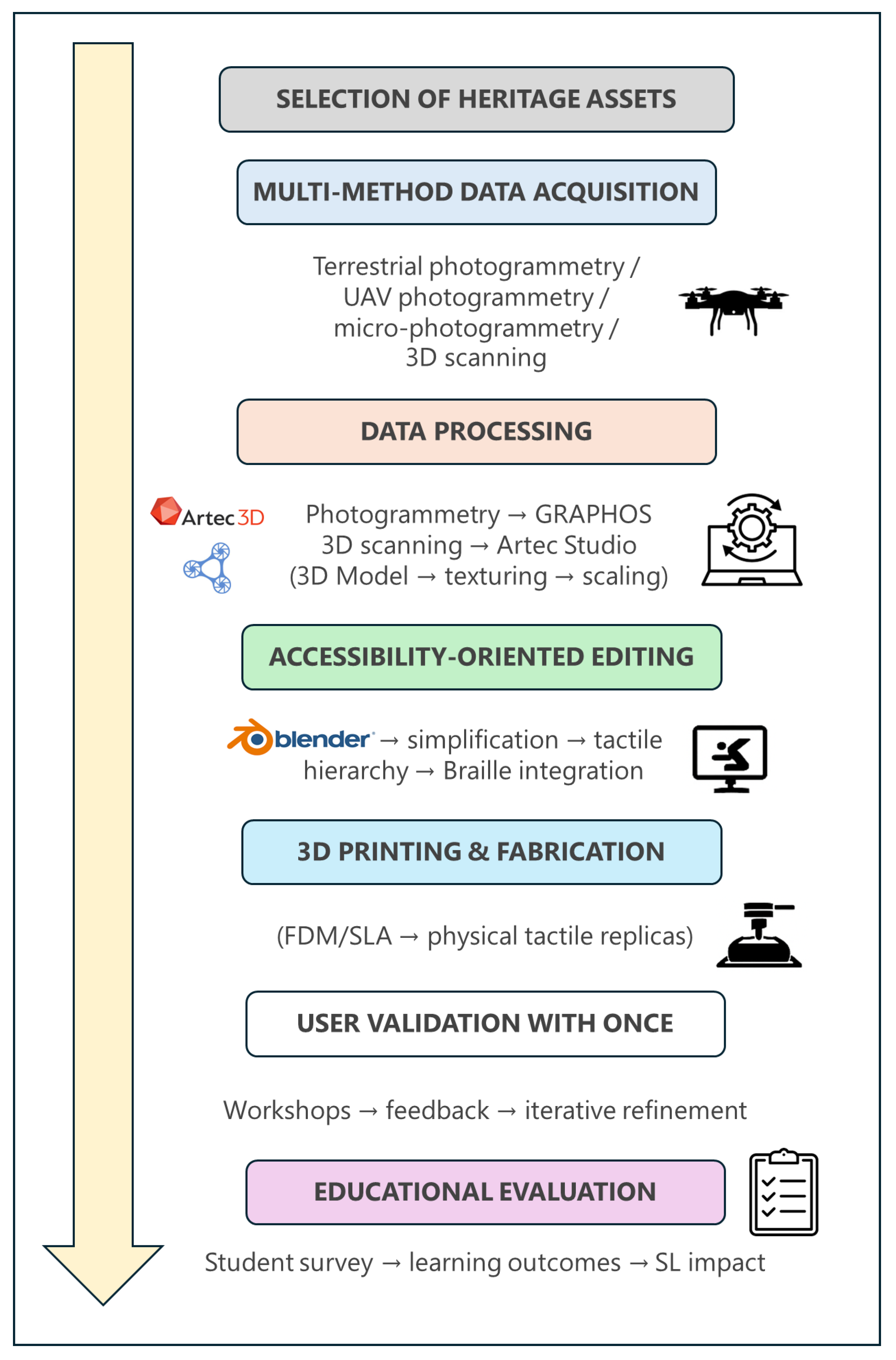
Figure 1. Overview of the PATCULT 3D methodological workflow, from data acquisition to accessible 3D model production and validation.
Applsci 15 12425 g001
Figure 2. Location and main heritage elements documented in the province of Ávila. (1) Statue of San Segundo (Ávila), (2) Aunqueospese Castle (Mironcillo), (3) Rock Sanctuary of Ulaca (Solosancho), (4) Fibulae from the Museum of Ávila, (5) Verraco from Las Cogotas oppidum (Ávila), (6) San Vicente Gate (Ávila), (7) Torreón de los Guzmanes Palace (Ávila), (8) Arenas de San Pedro Castle, (9) Guisando Bulls (El Tiemblo), and (10) Arévalo Castle. Each red dot shows the locations of each heritage element.
Applsci 15 12425 g002
Figure 3. Example of a close-range photogrammetry protocol applied to the verraco of Las Cogotas oppidum (Ávila). The acquisition scheme illustrates a circular and convergent shooting sequence with DSLR cameras, maintaining constant distance and focal length to ensure high image overlap and accurate 3D reconstruction. The yellow dots represent the camera positions (photos taken). The red arrows indicate the viewing direction of each photograph. The black line represents the circular path followed by the camera in an oblique-convergent acquisition protocol.
Applsci 15 12425 g003
Figure 4. Example of UAV-based photogrammetry flight planning over the Castle of Aunqueospese (Ávila). The acquisition strategy combined nadiral and oblique flights at different angles (30°, 45° and 60°), ensuring complete coverage of both horizontal and vertical surfaces. The yellow dots represent the camera positions (photos taken). The red arrows indicate the viewing direction of each photograph. The black line represents the circular path followed by the camera in an oblique-convergent acquisition protocol.
Applsci 15 12425 g004
Figure 5. Setup for micro-photogrammetry of small artifacts. (a) DSLR camera mounted on a fixed tripod facing a white rotating turntable on which the artifact is placed. (b) Integration of the turntable inside a white light box providing diffuse illumination and homogeneous background.
Applsci 15 12425 g005
Figure 6. High-resolution 3D scanning workflow using Artec Eva and Artec Spider scanners (Artec 3D, Senninger-berg, Luxembourg). (a) Left: data acquisition phase with the scanner and a rotating turntable for systematic coverage; Right: real-time frame capture in Artec Studio v.19.2.4.8 showing the alignment histogram; (b) Left: manual selection of key correspondences for global registration; Right: alignment result displaying the registered partial scans; (c) Left: generation of the fused and cleaned mesh after Sharp Fusion; Right: final textured 3D model ready for visualization, integration with photogrammetric data, and 3D printing.
Applsci 15 12425 g006
Figure 7. Workflow for the creation of the tactile 3D map of the historic city of Ávila in Blender v.4.2. (a) Import and alignment of cadastral vector data and street network; (b) extrusion of building footprints and city walls to create volumetric representation; side view of the model to verify relative heights and scale consistency; (c) simplified final version optimized for tactile readability, with hierarchical differentiation of blocks and streets.
Applsci 15 12425 g007
Figure 8. Examples of 3D-printed Braille information plaques accompanying the tactile models. The labels combine raised text and Braille transcription, using high-contrast colors to ensure readability for both visually impaired and partially sighted users.
Applsci 15 12425 g008
Figure 9. (a) Tactile models of Ávila’s heritage elements displayed on wooden bases with integrated Braille signage. (b) User testing session in collaboration with ONCE, where a participant with visual impairment explores the tactile map and models, validating their spatial readability and ergonomic design.
Applsci 15 12425 g009
Table 1. Main instruments and software used in the project, including their technical specifications and primary applications.
InstrumentModelKey SpecificationsUse
Digital Single Lens Reflex (DSLR) CameraCanon EOS 700D + Canon EF-S 60 mm f/2.8 Macro (Canon Inc., Ōta-ku, Tokyo, Japan)18 MP APS-C sensor; max. resolution 5184 × 3456 px; fixed focal macro lens; high sharpness for close-range workMicro-photogrammetry of small artifacts
DSLR CameraNikon D5600 + AF-P 18–55 mm (Nikon Corporation, Tokyo, Japan)24.2 MP APS-C sensor; max. resolution 6000 × 4000 px; variable focal length (used at fixed focal values); high portabilityTerrestrial photogrammetry of medium-scale elements
UAVDJI Mavic 2 Pro/DJI Matrice 350 RTK (SZ DJI Technology Co., Ltd., Shenzhen, China)20 MP 1” CMOS Hasselblad sensor; mechanical shutter; accuracy: ±0.1 m (vertical), ±0.3 m (horizontal)/20 MP RGB sensor (Zenmuse P1); RTK positioning accuracy ±0.1 m (vertical), ±0.3 m (horizontal); mechanical shutterAerial photogrammetry
3D ScannerArtec Eva (Artec 3D, Senningerberg, Luxembourg)Accuracy up to 0.1 mm; 3D resolution 0.5 mm; working distance 0.4–1.0 mMedium-size objects (sculptures, architectural fragments)
3D ScannerArtec Spider (Artec 3D, Senningerberg, Luxembourg)Accuracy up to 0.05 mm; 3D resolution 0.1 mm; working distance 0.17–0.35 mSmall objects with fine morphological detail
Photogrammetry SoftwareGRAPHOS v.2.0.0.beta.8Complete SfM–MVS pipeline; SIFT-based feature extraction; GNSS-assisted matching; dense cloud + mesh + texture generation; open-sourceProcessing of terrestrial, aerial, and micro-photogrammetry datasets
3D Scanning SoftwareArtec Studio v.19.2.4.8Real-time alignment; global registration (ICP); Sharp Fusion mesh creation; advanced texture mapping; scale and accuracy controlProcessing and fusion of structured-light scanning datasets
Table 2. Representative survey items used to assess key learning outcomes and student perceptions in the PATCULT 3D project.
CategoryItem (Shortened)MeanSD
Photogrammetry & Data Acquisition SkillsDSLR acquisition protocols4.50.5
UAV Mission Planning & Aerial WorkflowsUAV mission planning4.30.6
3D Scanning & Structured-Light ProcessingArtec Eva/Spider operation4.20.7
Accessibility-Oriented 3D Editing (Blender)Model optimization4.60.5
Learning Process & Instructional ClarityClarity of instructions4.70.4
Accessibility Awareness & Social Impact PerceptionValue of accessibility4.40.6
Overall Satisfaction with the PATCULT 3D ExperienceOverall satisfaction4.60.5
Disclaimer/Publisher’s Note: The statements, opinions and data contained in all publications are solely those of the individual author(s) and contributor(s) and not of MDPI and/or the editor(s). MDPI and/or the editor(s) disclaim responsibility for any injury to people or property resulting from any ideas, methods, instructions or products referred to in the content.