Abstract
This study examines the kinematic behavior of a large-scale colluvial landslide in a coastal low-elevation forest, where rainfall, geological formations, and hydrological conditions drive substantial slope displacement. The landslide comprises a colluvial layer overlying mudstone, with downslope movement toward the coastline induced by gravitational forces and infiltration. Using GPS surveys, inclinometers, soil moisture sensors, and numerical modeling, the temporal and spatial patterns of displacement were analyzed. Maximum horizontal displacements reach 8.1 cm/year, with deep-seated movements extending over 25 m into the mudstone. Key mechanisms include weakening of the colluvium–mudstone interface and creep within saturated mudstone, while a hydraulic barrier near the coastline restricts subsurface flow. Progressive upslope migration of the freshwater-bearing mudstone zone under annual rainfall further contributes to long-term deformation. These findings provide critical insights into the hydrologically controlled kinematics of coastal colluvial landslides.
1. Introduction
Slope failures are among the most prevalent natural hazards, particularly in regions subject to extreme weather conditions, such as high-intensity rainfall. Slope instability is influenced by a combination of environmental factors, including topography, geology, hydrology, and vegetation [1]. Among these, rainfall is widely recognized as the primary trigger of slope failures. Rainfall-induced infiltration elevates soil water content in the shallow subsurface, which in turn increases driving forces while reducing soil shear strength [2]. These processes substantially enhance the likelihood of slope instability and failure.
Numerous case studies across different regions have documented rainfall-induced landslides of varying scales [2,3,4,5,6]. For example, Jeong et al. [6] examined a colluvium-covered slope failure in the Umyeonsan region of Seoul, Korea, and demonstrated that the landslide was closely linked to rainfall infiltration, soil characteristics, slope geometry, and vegetation cover. Similarly, Shinohara et al. [7], through an extensive landslide inventory in Japan, revealed that the governing factors of slope failures vary depending on the landslide type, such as steep-slope failures, deep-seated landslides, and debris flows.
In recent years, climate change has further amplified the occurrence of such hazards. Intense and short-duration precipitation events have become increasingly frequent, leading to greater landslide activity worldwide. Recent studies indicate that the frequency, magnitude, and spatial extent of rainfall-induced slope failures have increased markedly under changing climatic conditions, particularly in response to extreme and prolonged rainfall events [8,9].
Slope failures constitute one of the most pressing environmental and geohazard challenges worldwide [7,10]. These events not only accelerate ecological degradation but also impose severe risks to infrastructure, residential communities, and public safety. Consequently, the prevention and mitigation of slope failures, particularly large-scale landslides, have emerged as central priorities in disaster risk reduction and sustainable land management.
Landslides are often governed by complex and site-specific interactions among geomorphological, geological, and hydrological processes [5,11,12,13,14]. Mudstone slopes, in particular, exhibit material-dependent behavior that renders them highly susceptible to instability [11,14]. Structural discontinuities, such as early-formed joints, can alter subsurface hydrology by creating preferential flow paths, thereby enhancing infiltration and promoting failure under rainfall [14]. Rainfall-induced soil–water interactions may trigger displacements to depths of 60–95 m in slopes dominated by tuff and breccia [13]. Anthropogenic factors, including reservoir drawdown, can further exacerbate instability; for example, a slow-moving landslide along a weak mudstone layer was primarily triggered by downstream reservoir drawdown [11]. These studies highlight the central role of material properties and structural heterogeneity in governing slope hydrology and failure mechanisms. Notably, landslide sites in atypical environmental settings may exhibit unique, poorly understood mechanisms, emphasizing the need to advance knowledge for improved landslide assessment, prediction, and long-term hazard management.
This study examines the kinematic mechanisms driving the long-term displacement of a coastal colluvial landslide situated within a low-elevation forest. Over the past three decades, a village located downslope of the site has experienced significant ground movement, raising persistent concerns about community safety. The proximity of the landslide’s lower boundary to the coastline further exacerbates its instability and amplifies the associated hazard potential.
To investigate the processes governing slope movement, a field instrumentation program was implemented to monitor in situ displacements and hydrological conditions during rainfall events. Complementary numerical modeling was then conducted to elucidate the interactions between hydrological processes within the geological formation and the resulting slope deformations. The findings of this study provide new insights into the long-term dynamics of coastal colluvial landslides and contribute to the development of more effective risk management strategies, addressing longstanding safety concerns expressed by local authorities.
2. Materials and Methods
2.1. The Landslide Site
The landslide site is situated within a low-elevation forest, with the mountain summit reaching E.L. +356 m, and is predominantly mantled by colluvium. An aerial view of the area, along with its geographical context, is shown in Figure 1. At the lower portion of the slope lies a village, Chai-san Village, which is surrounded by a largely undeveloped forest dominated by mixed woodland. The slope trends north–south and dips westward. The central area of the village within the study region is located at 22°38′38.0″ N, 120°15′12.2″ E. The forest area is characterized as a subtropical broadleaf forest, covered by diverse tree and shrub species. Dominant plant species include Camphora officinarum, Sapindus saponaria, Ficus microcarpa, Celtis nervosa, Lagerstroemia subcostata, Vitex negundo, Ficus septica, Broussonetia papyrifera, Macaranga tanarius, and Arenga engleri, among others. The vegetation is dense, with tree heights ranging from a few meters to approximately 20 m.
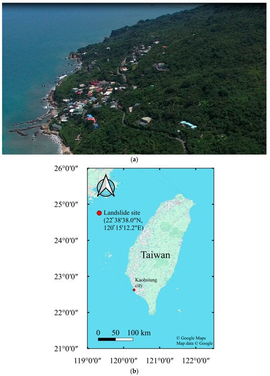
Figure 1.
Location of the landslide site: (a) aerial view (view from the south) and (b) geographical location.
For several decades, Chai-san Village has been affected by persistent slope displacement, with substantial deformations occurring at multiple locations [15]. Observable indicators of slope instability include road subsidence, surface tension cracks, and structural deformation of buildings. As shown in Figure 2a, a section of paved road has subsided by approximately 5–6 m. The road subsidence is based on long-term observations conducted at the site since 2005. However, systematic surveying was not implemented during the initial years; therefore, reliable measurements of road settlement from that period are not available. Figure 2b depicts a building that has undergone lateral displacement of 3–4 m from its original location adjacent to the road.
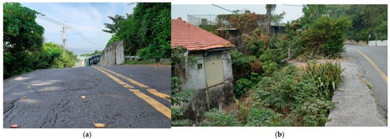
Figure 2.
Slope displacement at the landslide site: (a) significant subsidence on the paved road and (b) significant lateral movement and subsidence of a village house (away from the paved road).
The slope’s catchment area spans approximately 30 hectares [15], with the village positioned at the downslope region, near the coastline. This location makes Chai-san Village particularly vulnerable to the ongoing slope movements, increasing the risk to both infrastructure and residents.
2.2. Geology, Topography, and Hydrology at the Site
The landslide site features a slope covered by colluvium, resting atop a mudstone deposit. In this region, dark gray mudstones interspersed with sandstones and capped by hard limestone were deposited in a shallow marine environment approximately 1.25 million years ago [16]. Over time, the area has undergone compression, uplift, folding, and fracturing, shaping the geological landscape and contributing to the formation of Mt. Shou. Figure 3 illustrates the geological evolution of Mt. Shou. During the uplift and compression processes, faults developed within the mudstone deposit, leading to probable cracks and fractures in its upper layers. The overlying limestone gradually decomposed due to weathering and environmental factors, ultimately causing structural collapses. Subsequent geological periods saw multiple landslides, depositing colluvium layers ranging from several tens of meters to a few meters in thickness, extending from the upper slope of the mountain to the coastal area.
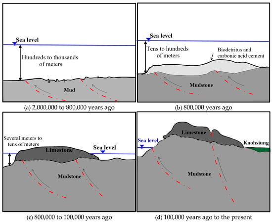
Figure 3.
Schematic diagram of the geological evolution of Mt. Shou (redrawn from [17]).
Between 2005 and 2014, geological exploration at the landslide site involved approximately 50 boreholes. The colluvium, primarily composed of decomposed limestone and soils of varying particle sizes, ranges in thickness from 3 m to 15 m in the downslope region [15]. The region experienced significant slope displacements. Thick mudstone layers underlie the colluvium. Laboratory tests on core samples in the area tens of meters from the coastline indicate that certain mudstone sections are highly saturated.
The topography of the site (Figure 4) is characterized by a westward-inclined slope with an average gradient of 15° to 25° [15].
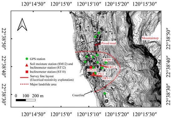
Figure 4.
Topography and instrumentation map at the site.
2.3. Instrumentations
An instrumentation system was installed and maintained at the site to monitor slope displacement and groundwater conditions. Over time, several inclinometers fractured at depths where significant displacements occurred, requiring multiple reinstallations over the past 15 years. As of 2018, eleven out of the nineteen inclinometers remained operational. Data from stations ST10 and ST12, located in areas experiencing pronounced slope movements, are presented to illustrate lateral displacement patterns with depth. The locations of inclinometer stations ST10 and ST12 are shown in Figure 4. The inclinometer data were collected using the Digital Inclinometer Spiral Sensors (RST Instruments Ltd., BC, Canada) by Geofield Engineering Consultant Ltd., Taiwan, specializing in geotechnical instrumentation and monitoring.
In addition to inclinometers, the site was equipped with twenty groundwater observation wells and twelve GPS stations to track ground surface displacements, with most of these instruments installed in and around the village. GPS surveys of horizontal ground displacements were conducted at intervals of approximately three years, except for two surveys carried out in 2016. The static relative positioning technique was employed for the GPS surveys. Data collection utilized a Trimble NetR9 reference receiver together with a TRM57971.00 antenna. GNSS observations employed both GPS and GLONASS satellites, using the Final Ephemerides provided by the International GNSS Service (IGS). GPS station positions were determined in the International Terrestrial Reference Frame (ITRF) using the two-degree zone Transverse Mercator projection with the Taiwan Datum 1997 (TWD97), from which east–north–up (ENU) coordinates were derived. Each observation lasted 180 min, with data recorded at 5 s intervals for satellites above a 15° elevation mask. GNSS positioning solutions were processed with Topcon MagNet Tools v8.1.2.
Furthermore, vertical ground displacements at the GPS stations were derived from leveling data acquired simultaneously with GPS measurements. The leveling was conducted using a Trimble DiNi03 electronic level with a Trimble LD13 invar rod, with a precision criterion requiring a closing error less than 8 mm√K (where K denotes the distance in kilometers). A stable control station was established beyond the landslide area.
Further enhancing monitoring efforts, nine soil moisture sensors were deployed at station SM12, next to the inclinometer station ST12, in 2017, positioned at varying depths (0.5 m to 8 m) within the village [15]. These sensors continuously recorded data through an autologging system.
Figure 4 provides an overview of the layout of GPS stations, soil moisture sensors, and major slope inclinometers, illustrating the comprehensive monitoring setup at the landslide site.
2.4. Electrical Resistivity
Electrical resistivity exploration was conducted at multiple cross-sections in the village area to assess soil moisture distribution on the slope during the dry season of 2012 by the Kaohsiung City Government [18]. The locations of the resistivity tests, ERT-1 in the village area and ERT-2 on the upper slope, are shown in Figure 4.
Electrical resistivity measurements offer valuable insights into the spatial distribution of moisture within geological deposits. Figure 5a illustrates the electrical resistivity distribution (ERT-1) along a vertical cross-section of the slope, where significant slope displacements have been observed. The electrical resistivity of geological materials is directly correlated with their moisture content. Along ERT-1, most mudstone deposits exhibited resistivity values below 20 ohm-meters. In particular, materials with resistivity values approximately between 5 and 20 ohm-meters are expected to have voids largely filled with moisture [19].
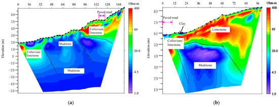
Figure 5.
Distribution of the electrical resistivity on the slopes: (a) profile ERT-1 and (b) profile ERT-2 (modified from [18]). Remarks: the digits at the top coordinates represent the distance along the survey line, with the distance “0” corresponding to the western end point of the survey line in Figure 4.
Additionally, geological exploration was conducted to a depth of 8 m at station SM12, near ERT-1. Analysis of mudstone samples collected from depths of G.L. −4 m to G.L. −8 m revealed saturation levels ranging from 75% to 90%, further confirming the high moisture content in the subsurface.
Additionally, Figure 5b presents the electrical resistivity data for the vertical cross-section at the upper elevation of the village area (ERT-2). In most of this area, extending to a depth of 10 m, resistivity values were relatively high (approximately 100 to 400 ohm-meters), indicating that the geological deposit primarily consists of colluvium, including decomposed limestone, and soils. This suggests minimal moisture content at shallow depths. However, within the mudstone deposit, the electrical resistivity was significantly lower, suggesting higher moisture content in the mudstone at the higher elevations of the slope.
2.5. Numerical Modeling
This study utilized a numerical modeling approach to examine the long-term deformation behavior of the slope in the region. Slope responses were simulated using the PLAXIS 2D finite element software (version 2018) [20], incorporating stratigraphic data along with relevant geotechnical and hydrological parameters. The analysis spanned the period from 2013 to 2024 and focused on subsurface displacements and hydrological variations under rainfall conditions. Particular attention was given to the deformation characteristics of saturated mudstone layers to elucidate the relationship between sustained slope deformation and the coupled hydro-mechanical behavior of these strata.
Figure 6 illustrates the finite element model of the slope, constructed using high-resolution topographic data. The model profile intersects the GPS station GPS10, as shown in Figure 4. The model extends 100 m below sea level and projects 100 m seaward, comprising 1137 finite elements and 9423 nodes. It incorporates the freshwater–seawater interface within the mudstone strata beneath sea level, as well as zones of high-moisture-content mudstone identified through field investigations. Monthly rainfall records from 2013 to 2024 were used as input for the numerical simulations, as presented in Figure 7.
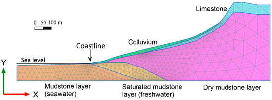
Figure 6.
The finite element mesh of the slope.
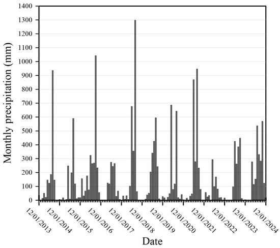
Figure 7.
The monthly precipitation at the site from 2013 to 2024.
To accurately capture the deformation behavior of the colluvial deposits and the highly saturated mudstone layers, the soft soil creep model was employed, whereas the hardening soil model [20] was applied to the remaining geological formations. The geotechnical and key parameters for determining the soil water characteristic curve (SWCC) used in the simulations are summarized in Table 1 and Table 2, respectively. The hydraulic response of the unsaturated layers was simulated using the van Genuchten (1980) [21] formulation, which is characterized by five key parameters listed in Table 2. Parameters for the limestone and mudstone layers were obtained from the literature, as reported in Table 1 and Table 2. Specifically, limestone strength parameters were taken from Hendron (1968) [22]; colluvium strength parameters were conservatively estimated, with SWCC parameters determined by pressure plate extractor tests; the Young’s modulus of dry mudstone was adopted from Lu et al. (2017) [23]; the saturated mudstone strength and SWCC parameters were based on Blake et al. (2023) [24] and Yang et al. (2023) [25]; saturated mudstone’s consolidation parameters were obtained from Hsiao and Hsieh (2022) [26] and Mesri and Castro (1987) [27].

Table 1.
Strength parameters for various geological layers.

Table 2.
Hydrological parameters for mudstone layers.
The numerical modeling aims to investigate the kinematic mechanism of deformation and hydraulic conditions within the slope. Direct comparison with monitored data is not undertaken, as several key factors cannot be obtained or quantified with sufficient reliability. These include detailed geological structure, mechanical and hydraulic properties of geological layers, site-specific hydrological conditions, high-resolution topography, and the historical record of slope deformation.
3. Results
3.1. Ground Displacements
Figure 8 illustrates the distribution of horizontal ground displacement in the village area during the period from 2013 to 2024, based on GPS data. GPS displacements at each ground-surface instrumentation station were calculated from coordinate differences between 2013 and 2024. The lateral ground displacement was predominantly directed westward toward the coastline. Data from station GPS09 have been unavailable since 2019 due to site damage. The precision of the calculated coordinates for each campaign ranged from 0.005 m to 0.008 m in the north direction and from 0.006 m to 0.010 m in the east direction.
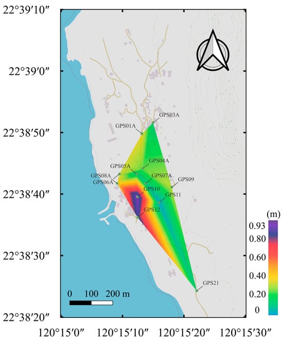
Figure 8.
Distribution of horizontal ground displacement based on GPS data in the village area from 2013 to 2024.
Significant horizontal displacements were observed in the village area, particularly at GPS10 (located in front of a small temple) and GPS12 (approximately 50 m south of GPS10). At GPS10, the horizontal displacement rate was approximately 8.1 cm/year over the period from 2013 to 2024. Similarly, GPS12 recorded a displacement rate of 7.3 cm/year during the same period.
Figure 9 illustrates the distribution of vertical ground displacement (settlement) in the village area during the period from 2013 to 2024. The greatest settlement occurred at GPS10, with a rate of 2.7 cm/year. Similarly, GPS12 recorded a settlement rate of 2.0 cm/year, respectively, over the same period.
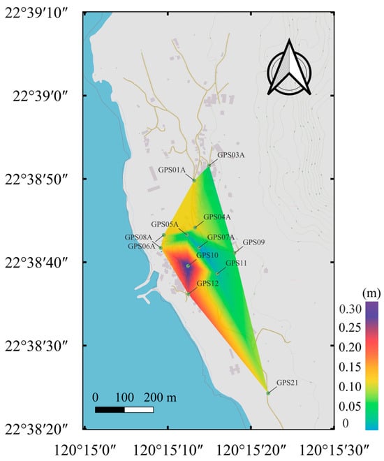
Figure 9.
Distribution of vertical ground displacement (settlement) based on leveling in the village area from 2013 to 2024.
Additionally, significant deep-seated displacement was observed at the landslide site, with two distinct displacement patterns occurring along the slope depth. Figure 10 presents the lateral displacement profiles at the inclinometer stations ST10 and ST12, where notable ground movements occurred between July 2012 and August 2021. At ST10, slope displacement revealed a distinct slip plane at a depth of 14 m, approximately 3 m below the colluvium–mudstone interface. However, inclinometer measurements ceased in September 2014 due to instrument failure at the slip plane. In contrast, station ST12 did not exhibit a clear slip plane, though substantial displacement was recorded within the mudstone layer. The inclinometers installed at ST12 reached only 25 m below ground level, with 22.5 m penetrating into the mudstone deposit. The displacement at ST12 indicated that the displacement likely extends beyond the inclinometer’s measurable depth.
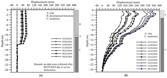
Figure 10.
Lateral displacement along the depth from inclinometer measurements. (a) Station ST10 and (b) Station ST12.
Figure 11 illustrates the distribution of lateral ground displacement derived from inclinometer measurements between 2013 and 2024. No data have been available for the inclinometers at stations ST1, ST6, ST8, ST9, ST10, ST13, ST19, and ST20 since 2018, as excessive slope displacement caused the sensors to seize at specific depths. Inclinometers installed to a depth of 25 m, with the base assumed to be fixed at G.L. –25 m, generally recorded ground displacements (Figure 10) that were substantially smaller than those obtained from GPS measurements (Figure 8). The difference is particularly evident at station ST10, located near GPS station GPS10, and at inclinometer station ST12, located near GPS station GPS12. For example, GPS data from 2013 to 2024 indicate a horizontal displacement of 0.80 m at GPS12, whereas the inclinometer at station ST12 recorded only 0.40 m at the ground surface. This discrepancy suggests that slope displacements extend beyond a 25 m depth within the mudstone deposits. The exact depth of this displacement remains undetermined, as the 25 m inclinometers could not capture movement beyond their installation depth.
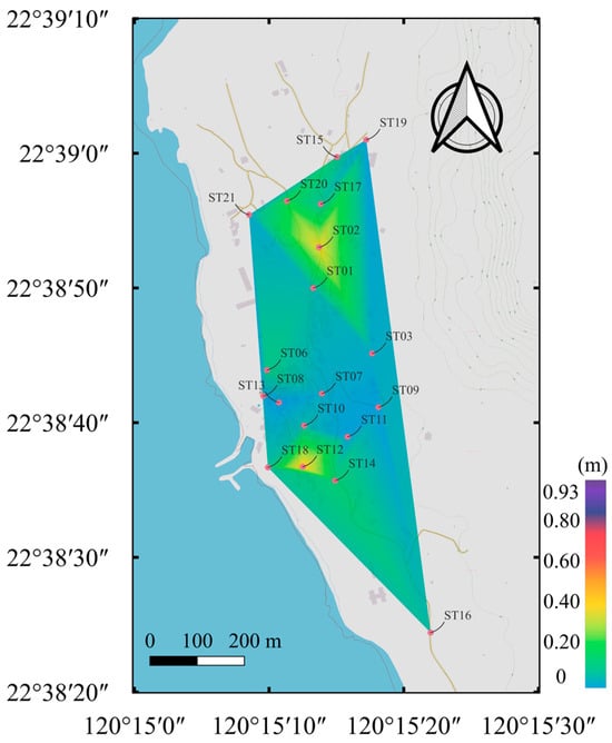
Figure 11.
Distribution of horizontal ground displacement based on the inclinometer data in the village area from 2013 to 2024.
Moreover, the village at the landslide site, established approximately 95 years ago, is located adjacent to the coastline (Figure 1) and is currently home to around 100 residents. The author of this manuscript conducted an interview with an 85-year-old resident who has lived in the same house for the past 50 years, offering valuable first-hand insights into long-term ground movements in the area. The resident provided the following observations:
- Houses near the coastline have gradually shifted downslope over several decades, with her home now significantly closer to the coast than 40 years ago.
- Localized subsidence within the village is ongoing and frequently observed, with ground cracks perpendicular to the sloping direction commonly forming as a result of small-scale surface collapses.
These long-term observations from local residents offer critical qualitative data that can enhance the understanding of the landslide site’s kinematic behavior, particularly when integrated with additional information, such as hydrological and geological data, instrumented monitoring records, and numerical analyses.
3.2. Hydrology at the Geological Deposits
Rainfall-induced infiltration reduces the shear strength of the slope, thereby contributing to instability. The soil water content at station SM12, located near stations GPS12 and ST12—where the most significant slope displacements have occurred over the past 20 years—is monitored and analyzed herein. Figure 12 shows the variation in soil water content at depths of 0.5 to 8 m at SM12 from 2017 to 2021. The data indicate that the mudstone deposit at depths of 7–8 m was highly saturated prior to September 2018. At shallower depths, soil water content exhibited a strong correlation with precipitation, with notable increases following rainfall events, particularly above the colluvium–mudstone interface. Conversely, soil moisture decreased a few days after rainfall ceased. The large catchment area contributed to substantial infiltration and subsurface runoff, exacerbating moisture accumulation in the landslide-prone zone. A marked decline in soil water content at most depths was observed at SM12 after September 2018, attributable to the installation of horizontal drainage pipes near the station in August 2018 [29].
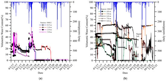
Figure 12.
Variation in soil water content along depth with time for station SM12 from April 2017 to February 2021. (a) depth = 0.5–3.0 m and (b) depth = 4–8 m. (Modified from [29]).
Groundwater monitoring data indicate that no groundwater was detected during the dry season. In contrast, rainfall events produced groundwater levels ranging from 1.0 to 2.5 m within the colluvium above the mudstone deposit in the village area. This accumulated groundwater typically dissipated within several days following heavy rainfall [15]. The elevated soil water content along the colluvium–mudstone interface, induced by rainfall, likely contributed to a reduction in shear resistance, potentially facilitating slope displacement. Laboratory tests further revealed high water content in the mudstone deposit below 4 m (G.L. −4m) [18]. This elevated moisture content is believed to have weakened the shear strength of the mudstone, promoting displacement within the mudstone layer and contributing to the observed slope movement, as illustrated in Figure 10b.
3.3. Hydro-Mechanical Behaviors of the Slope Investigated via Numerical Analysis
Figure 13 presents the displacement distribution within the strata over the 11-year period from 2013 to 2024. It is important to note that the numerical analysis primarily focuses on the deformation patterns within the landslide-prone area rather than the absolute magnitudes of slope displacement. The simulation results reveal that significant ground deformation occurred near the seaward area of the slope, with the affected zone extending to depths exceeding 50 m below ground level (G.L. –50 m). Notably, considerable displacements were observed at greater depths within the saturated mudstone layer in the coastal zone. In contrast, the upslope region, underlain by relatively dry mudstone, exhibited markedly smaller displacements than the saturated mudstone in the lower slope and coastal area.
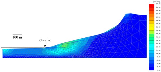
Figure 13.
The simulated displacement distribution pattern within the strata over an 11-year period from 2013 to 2024.
In addition, Figure 14 presents lateral displacement profiles with a depth at various locations along the slope. These results further confirm that the saturated mudstone layer in the lower slope undergoes more pronounced deformation with increasing depth compared to the relatively stable dry mudstone layer at higher elevations. Figure 15 complements these findings by providing time-series plots of displacement and shear strain at selected depths—specifically 7.5 m, 31.3 m, 57 m, and 74.51 m—at a lower slope location approximately 205 m from the coastline. These depths encompass both shallow strata and multiple levels within the saturated mudstone layer, as indicated in the inset figure.
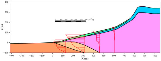
Figure 14.
The simulated lateral displacement distribution along the depth at different locations from the coastline over an 11-year period from 2013 to 2024.
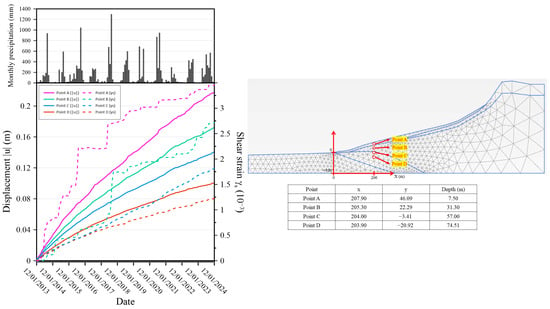
Figure 15.
The displacement distribution with time at different locations of the lower slope in the strata over an 11-year period from 2013 to 2024.
The results indicate a continuous increase in deformation and shear strain within the strata over an 11-year period, with significantly greater values observed at shallow depths than in deeper layers. Furthermore, the rate of deformation at shallow depths is markedly higher than that observed at deeper levels within the saturated mudstone. Notably, shear strain at shallow depths clearly correlates with rainfall events, a pattern not observed in the deeper saturated mudstone layer. These observations suggest the occurrence of long-term creep behavior within the saturated mudstone layer in the lower slope region.
Furthermore, Figure 16 illustrates the simulated hydraulic head distribution within the geological strata from 2013 to 2024. The results indicate that the coastal region maintains a higher hydraulic head than the upslope areas, with a gradual decline observed inland. This pattern reflects the presence of highly restricted subsurface flow within the saltwater-bearing mudstone deposits near the coastline. The findings suggest that groundwater within the freshwater-bearing strata does not readily infiltrate the saltwater-saturated mudstone zone, implying the existence of a hydraulic barrier that limits subsurface flow from the slope toward the coastal sea region. As a result, the effective aquifer within the freshwater mudstone appears to migrate upslope progressively over time. This upslope expansion of high-moisture zones in the mudstone induced by annual precipitation may promote the long-term development of creep-induced deformation within the slope strata, thereby contributing to the progressive destabilization of the slope.
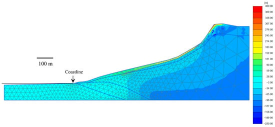
Figure 16.
The simulated distribution of hydraulic head within the strata over an 11-year period from 2013 to 2024.
4. Discussion
The data from the GPS and inclinometers installed on the slope showed that the slope has experienced significant displacements in the shallow colluvium region over the past 20 years. Additionally, the mudstone deposits at greater depths have also undergone noticeable displacements. Rainfall was identified as the primary trigger for slope displacement. Groundwater rose 2 to 3 m above the colluvium–mudstone interface during heavy rainfall. The mudstone deposit exhibited high saturation levels, with a water content ranging from 13.6% to 24.9%. Probable discontinuities or cracks in the mudstone deposit may facilitate subsurface runoff infiltration over a long period of time. Instrumentation data revealed two distinct displacement patterns:
- Shallow displacement along the colluvium–mudstone interface, triggered by rainfall-induced infiltration, which softened the interface and led to slope movement.
- Deeper displacement within the mudstone deposit, reaching greater than 25 m, is primarily driven by long-term saturation and weakened shear strength.
Moreover, the numerical simulation of long-term slope displacements under annual rainy season conditions conducted in this study clearly demonstrates that the geological and geomorphological characteristics of the site play a critical role in controlling slope deformation behavior. The simulated displacement patterns indicate that deformation primarily develops in the lower slope area of the landslide site and may extend to depths of approximately 60–100 m at different locations below the ground surface. Notably, this deformation reaches well beyond the 25 m installation depth of the site’s inclinometers. These findings provide important insights into the mechanisms driving long-term slope deformation in this landslide-prone area and offer a valuable foundation for developing future disaster prevention and risk mitigation strategies in the region.
Figure 17 illustrates the slope displacement kinematics at the coastal colluvium landslide site, which dips toward the coastline. Tension cracks likely developed at the top of the mudstone deposit during tectonic uplift of the regional mountains. Rainfall-induced subsurface runoff from the catchment area may infiltrate the mudstone through these probable cracks for a long period of time, accumulating in the lower slope near the coast. At the landslide site, a freshwater–saltwater interface within the mudstone deposits is likely to develop in the coastal area [15], as shown in Figure 17. The hydraulic head in the deposits near the coastline is noticeably higher than that at the middle and upper slopes, creating a barrier that impedes subsurface runoff from discharging directly into the ocean. Consequently, these hydrological conditions promote high saturation levels in the mudstone deposit, reducing shear resistance and increasing susceptibility to creep deformation, particularly under high saturation. Previous research [23,30] has demonstrated that high water saturation in mudstones leads to enhanced creep deformation and elevated strain rates, as evidenced by uniaxial compression and multistage creep tests.
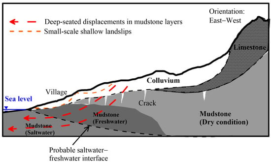
Figure 17.
Illustration of slope displacement kinematics at the coastal colluvial landslide site. Remarks: 1. Question marks denote the presumed surface. 2. The figure is not drawn to scale.
Based on field data, historical observations, and numerical modeling, we propose two primary kinematic behaviors driving slope displacement:
- Rainfall-induced localized slope displacements within the colluvium, where infiltration weakens the colluvium–mudstone interface.
- Creep deformation within the saturated mudstone deposit, which is exacerbated by long-term moisture accumulation, high water head in the coastal area, and the probable presence of a saltwater–freshwater interface near the coastline. The slope displacement may reach up to 100 m below the ground surface in the lower slope area close to the coastline based on the results of the numerical modeling.
Taiwan is located in a seismically active region, where seismic activity may significantly influence slope displacement. Future investigations at the landslide site should explicitly consider these seismic effects to enhance hazard assessment and guide effective mitigation strategies.
This study compiles and analyzes over a decade of field instrumentation records, including measurements of slope displacement at multiple depths, surface ground displacement, soil water distribution at various depths, etc., associated with numerical modeling. The western sector of Mt. Shou, which extends for approximately 5 km along the coastline, exhibits a relatively consistent geological evolutionary history that serves as a critical framework for interpreting the deformation patterns observed in the area. Within this setting, the hydrological regime—particularly the distribution of hydraulic head in the mudstone strata underlying the lower coastal slopes—emerges as a dominant factor controlling the spatial and temporal variability of slope displacement. Notably, variations in the geological and hydrological conditions may directly govern the hydraulic pressure within these layers, which in turn influence the magnitude and rate of slope movement, with measurable effects on annual displacement trends.
The outcomes of this investigation have significant implications for both regional and global perspectives. At the regional scale, the findings contribute to the refinement of site-specific landslide hazard assessments and the design of risk mitigation and management strategies. At a broader scale, the results offer transferable insights into the mechanisms governing long-term slope displacement in areas that exhibit comparable lithological, geomorphological, and hydrological characteristics worldwide. By integrating long-term monitoring data with an understanding of underlying geological processes, this research advances the scientific basis for predicting slope stability and managing landslide risk in coastal and other geologically sensitive environments.
5. Conclusions
This study investigates the kinematic mechanisms underlying long-term slope displacement at a coastal landslide site within a low-elevation forest. Inclinometer data indicate that horizontal displacements extend more than 25 m into the underlying mudstone, evidencing deep-seated instability, except for localized shallow movements within the colluvium primarily induced by rainfall infiltration.
High saturation within the mudstone at lower slope elevations, together with an elevated hydraulic head near the coastal margin, are the principal drivers of the observed displacements. Numerical simulations further reveal the presence of a hydraulic barrier that restricts subsurface flow from the slope toward the coast, causing the freshwater-bearing mudstone zone to progressively migrate upslope over time. This process induces creep deformation within the saturated mudstone, which is identified as the dominant mechanism of deep-seated displacement. Overall, the interplay between slope morphology, lithological composition, and hydrological processes exerts a critical control on slope movement and deformation patterns.
Slope displacement at the study site has long challenged local authorities. This study confirms deep and persistent movements in the lower-elevation areas near the coastal village. Conventional engineering measures, including rock anchors, retaining walls, and piles, may be inadequate for this site-specific landslide. These findings underscore the need for more appropriate strategies for landslide hazard management to ensure the village’s long-term safety.
Author Contributions
Conceptualization, C.-C.F.; methodology, C.-C.F.; validation, C.-C.F., T.-H.W. and C.-J.Y.; formal analysis, C.-C.F. and C.-J.Y.; investigation, C.-C.F. and T.-H.W.; resources, C.-C.F. and K.-W.H.; data curation, C.-C.F. and C.-J.Y.; writing—original draft preparation, C.-C.F.; writing—review and editing, C.-C.F. and T.-H.W.; visualization, C.-J.Y.; supervision, C.-C.F.; project administration, C.-C.F.; funding acquisition, C.-C.F. All authors have read and agreed to the published version of the manuscript.
Funding
This research was funded by the National Science and Technology Council, Taiwan, ROC, grant numbers MOST 106-2119-M-327-001 and MOST 107-2119-M-327-001.
Data Availability Statement
The data that support the findings in the research are available upon reasonable request.
Acknowledgments
The authors thank the Water Resources Bureau of the Kaohsiung City Government for providing the slope inclinometer, GPS, electrical resistivity, and groundwater data. Moreover, the authors also wish to thank Ruey-Zen Chang (Geofield Engineering Consultants Ltd., Taiwan), Wen-Guey Ke (Geofield Engineering Consultants Ltd., Taiwan), Jin-Zong Lu, Yu-Bin Lo, Shang-Zhi Lin, Hsin-Hong Chen, and Sheng-Fu Lin for their assistance during the fieldwork and drawing. The authors also express their sincere gratitude to Chung Hsing Surveying Co., Ltd., Taiwan, for their assistance with the survey work and for providing valuable technical information.
Conflicts of Interest
Author Tsung-Hsien Wang was employed by the company SINOTECH Engineering Consultants, Ltd. The remaining authors declare that the research was conducted in the absence of any commercial or financial relationships that could be construed as a potential conflict of interest.
References
- Iverson, R.M. landslide triggering by rain infiltration. Water Resour. Res. 2000, 36, 1897–1910. [Google Scholar] [CrossRef]
- Wayllace, A.; Thunder, B.; Lu, N.; Khan, A.; Godt, J.W. Hydrological Behavior of an Infiltration-Induced Landslide in Colorado, U.S.A. Geofluids 2019, 2019, 1659303. [Google Scholar] [CrossRef]
- Schuster, R.L.; Salcedo, D.A.; Valenzuela, L. Overview of catastrophic landslides of South America in the twentieth century. In Catastrophic Landslides Effects, Occurrence, and Mechanisms; Evans, S.G., DeGraff, J.V., Eds.; Reviews in Engineering Geology; Geological Society of America: Boulder, CO, USA, 2002; pp. 1–33. [Google Scholar]
- Lagmay, A.M.A.; Ong, J.B.T.; Fernandez, D.F.D.; Lapus, M.L.; Rodolfo, R.S.; Tengonciang, A.M.P.; Soria, J.L.A.; Baliatan, E.G.; Quimba, Z.L.; Uichanco, C.L.; et al. Scientists investigate recent Philippine Landslide. Eos Trans. Am. Geophys. Union 2006, 87, 121. [Google Scholar] [CrossRef]
- Xie, X.; Li, D.; Miao, F.; Yan, L.; Leo, C.; Sun, Y. The Kangjiapo landslide in Wanzhou district, Chongqing city: Reactivation of a deep-seated colluvial landslide in the Three Gorges Reservoir. Bull. Eng. Geol. Environ. 2023, 82, 386. [Google Scholar] [CrossRef]
- Jeong, S.; Lee, K.; Kim, J.; Kim, Y. Analysis of Rainfall-Induced Landslide on Unsaturated Soil Slopes. Sustainability 2017, 9, 1280. [Google Scholar] [CrossRef]
- Shinohara, Y.; Watanabe, Y. Differences in factors determining landslide hazards among three types of landslides in Japan. Nat Hazards 2023, 118, 1689–1705. [Google Scholar] [CrossRef]
- Jemec Auflič, M.; Bezak, N.; Šegina, E.; Frantar, P.; Gariano, S.L.; Medved, A.; Peternel, T. Climate change increases the number of landslides at the juncture of the Alpine, Pannonian and Mediterranean regions. Sci. Rep. 2023, 13, 23085. [Google Scholar] [CrossRef]
- Chen, C.; Tung, Y.; Liou, J.; Li, H.; Chen, C.; Chen, Y.; Oguchi, T. Assessing landslide characteristics in a changing climate in northern Taiwan. Catena 2019, 175, 263–277. [Google Scholar] [CrossRef]
- Saadatkhah, N.; Kassim, A.; Lee, L.M. Qualitative and quantitative landslide susceptibility assessments in Hulu Kelang area, Malaysia. EJGE 2014, 19, 545–563. [Google Scholar]
- Li, D.; Yan, L.; Wu, L.; Yin, K.; Leo, C. The Hejiapingzi landslide in Weining County, Guizhou Province, Southwest China: A recent slow-moving landslide triggered by reservoir drawdown. Landslides 2019, 16, 1353–1365. [Google Scholar] [CrossRef]
- Mebrahtu, T.K.; Hussien, B.; Banning, A.; Wohnlich, S. Predisposing and triggering factors of large-scale landslides in Debre Sina area, central Ethiopian highlands. Bull. Eng. Geol. Environ. 2021, 80, 365–383. [Google Scholar] [CrossRef]
- Kang, X.; Wang, S.; Wu, W.; Xu, G.; Zhao, J.; Liu, F. Soil–water interaction affecting a deep-seated landslide: From field monitoring to experimental analysis. Bull. Eng. Geol. Environ. 2022, 81, 82. [Google Scholar] [CrossRef]
- Li, K.; Sun, P.; Wang, H.; Ren, J. Insight into failure mechanisms of rainfall induced mudstone landslide controlled by structural planes: From laboratory experiments. Eng. Geol. 2024, 343, 107774. [Google Scholar] [CrossRef]
- Fan, C.; Luo, J.; Chang, R.; Huang, G. The mechanism of long-time displacement in a colluvium slope underlain by mudstone. In Proceedings of the 7th Asia-Pacific Conference on Unsaturated Soils, AP-UNSAT2019, Nagoya, Japan, 23–25 August 2019. [Google Scholar]
- Taiwan National Nature Park. Geological & Landscapes. Available online: https://www.nnp.gov.tw/en/cp.aspx?n=16402 (accessed on 25 May 2025).
- The Geography Society of Taiwan Located in Kaohsiung. Landscape Resource Survey and Surface Deformation Monitoring Planning Program for Shoushen National Nature Park; Research Report for Taiwan National Nature Park; The Geography Society of Taiwan Located in Kaohsiung: Kaohsiung, Taiwan, 2012; 99p. (In Chinese) [Google Scholar]
- Geofield Engineering Consultants, Ltd. Project for Monitoring and Remediating the Slopeland in Tao-Yuan Village in Kaohsiung; Report for Kaohsiung City Government; Geofield Engineering Consultants, Ltd.: Kaohsiung, Taiwan, 2014; 96p. (In Chinese) [Google Scholar]
- Samouelian, A.; Cousin, I.; Tabbagh, A.; Bruand, A.; Richard, G. Electrical resistivity survey in soil science: A review. Soil Tillage Res. 2005, 83, 173–193. [Google Scholar] [CrossRef]
- Bentley Systems Incorporated. PLAXIS 2D 2024.3 Reference Manual. 2024. Available online: https://bentleysystems.service-now.com/community?id=kb_article&sysparm_article=KB0107989 (accessed on 15 January 2025).
- Van Genuchten, M.T. A closed-form equation for predicting the hydraulic conductivity of unsaturated soil. Soil Sci. Soc. Am. J. 1980, 44, 892–898. [Google Scholar]
- Hendron, A.J. Mechanical properties of rock. In Rock Mechanics in Engineering Practice; Stagg, K.G., Zienkiewicz, O.C., Eds.; John Wiley: New York, NY, USA, 1968; pp. 21–53. [Google Scholar]
- Lu, Y.; Wang, L. Effect of water and temperature on short-term and creep mechanical behaviors of coal measures mudstone. Environ. Earth Sci. 2017, 76, 597. [Google Scholar] [CrossRef]
- Blake, O.O.; Ramsook, R.; Faulkner, D.R.; Iyare, U.C. The effect of effective pressure on the relationship between static and dynamic Young’s moduli and Poisson’s ratio of Naparima Hill Formation mudstones. Rock Mech. Rock Eng. 2020, 53, 3761–3778. [Google Scholar]
- Yang, G.; Chen, Y.; Liu, X.; Yang, R.; Zhang, Y.; Zhang, J. Stability analysis of a slope containing water-sensitive mudstone considering different rainfall conditions at an open-pit mine. Int. J. Coal Sci. Technol. 2023, 10, 64. [Google Scholar]
- Hsiao, D.; Hsieh, C. Improving Mudstone Materials in Badland in Southwestern Taiwan by Increasing Density and Low-Cement Amount. Appl. Sci. 2022, 12, 2290. [Google Scholar] [CrossRef]
- Mesri, G.; Castro, A. Cα/Cc concept and K0 during secondary compression. J. Geotech. Eng. 1987, 113, 230–247. [Google Scholar] [CrossRef]
- Sakai, K.; Takatori, N.; Ogura, D.; Wakiya, S.; Abuku, M. Investigation of the transport properties for saline water in porous materials: Modeling of the permeability coefficient for saline water. J. Phys. Conf. Ser. 2021, 2069, 012214. [Google Scholar] [CrossRef]
- Fan, C.-C.; Wang, T.-H.; Huang, K.-W. Performance of long perforated HDPE pipes in the underground drainage of a landslide site. In Proceedings of the GeoAsia7 Conference & IGS First Young Engineers Conference (GeoAsia7), Taipei, Taiwan, 31 October 2022. [Google Scholar]
- Li, J.; Gao, Y.; Yang, T.; Zhang, P.; Deng, W.; Liu, F. Effect of water on the rock strength and creep behavior of green mudstone. Geomech. Geophys. Geo-Energ. Geo-Resour. 2023, 9, 101. [Google Scholar] [CrossRef]
Disclaimer/Publisher’s Note: The statements, opinions and data contained in all publications are solely those of the individual author(s) and contributor(s) and not of MDPI and/or the editor(s). MDPI and/or the editor(s) disclaim responsibility for any injury to people or property resulting from any ideas, methods, instructions or products referred to in the content. |
© 2025 by the authors. Licensee MDPI, Basel, Switzerland. This article is an open access article distributed under the terms and conditions of the Creative Commons Attribution (CC BY) license (https://creativecommons.org/licenses/by/4.0/).