Abstract
This study aims to develop a multi-dimensional framework to systematically identify optimal adjustment zones for converting orchard land into cultivated land, thereby providing a reference for spatial optimization of cultivated land within the context of integrating diverse land occupation activities into the requisition–compensation balance system. The research incorporates land quality evaluation, land-use conversion cost assessment, ecological loss analysis, and scenario-based simulations. The study demonstrates that (1) compared to the common practice of directly converting orchard land to cultivated land by only considering the slope, our multi-scenario optimization model for cultivated land reduces both economic and ecological losses. (2) For cities prioritizing ecological or economic development, selecting strategies under corresponding priority scenarios can maximize the protection of local ecological environments or maintain economic levels, thereby providing reserve resources for cultivated land optimization and adjustment. (3) Under the MMEG (EG: Ecological priority scenario) and MMEM (EM: Economic priority scenario) scenarios (MM: conversion of medium-low-grade orchard land to medium-high-grade cultivated land), the area of cultivated land optimal adjustment zones is the largest. The method of comprehensively identifying cultivated land optimal adjustment zones through multi-dimensional scenario settings is more comprehensive than the conventional approach that only considers slope. This method enhances cultivated land quality more effectively and protects both the ecosystem and the economy.
1. Introduction
Food security is a critical cornerstone of national security. In 2022, China proposed the concept of “establishing a broad food security perspective and building a diversified food supply system,” expanding cultivated land protection to major agricultural lands with grain potential (e.g., orchards). This expansion of food security to encompass food safety further underscores China’s resolve and strategic arrangements to ensure food security. China’s long-standing fundamental national condition features a large population and relatively scarce land. This scarcity underpins the critical importance of protecting and utilizing the limited cultivated land resources effectively. Consequently, safeguarding these resources is not only fundamental to enhancing national food security, but also serves as a vital bulwark against diverse external risks.
Since the reform and opening-up in 1978, China’s economy and society have developed rapidly, with the acceleration of various construction projects. This has led to a large number of cases of illegal occupation of cultivated land, causing a sharp reduction in the area of cultivated land. To strengthen land management and effectively protect cultivated land, China initiated the policy of cultivated land requisition–compensation balance in 1997. In 2024, the Central Government further refined this policy framework in the Opinions of the Central Committee of the Communist Party of China and the State Council on Strengthening the Work of Cultivated Land Protection and Restoration and Improving the Balance between Cultivated Land Occupation and Reclamation, which explicitly proposed new requirements: “coordinating the protection of cultivated land with other agricultural lands such as forestland and grassland” and “integrating all types of cultivated land occupation for non-agricultural construction, afforestation, fruit/tea planting into the management of cultivated land requisition-compensation balance.” This document, issued in 2024, has been formally implemented nationwide, marking an upgraded institutional design for cultivated land regulation.
However, current agricultural land conversion practices continue to encounter several critical challenges, including an overreliance on slope thresholds for orchard conversion while disregarding variations in land quality, as well as the difficulty of reconciling ecological protection with economic development at the present stage. Against this backdrop, the central research question of this study is how to scientifically identify optimal adjustment areas suitable for conversion to cultivated land based on orchard and cultivated land quality evaluations, thereby addressing the prevailing problems of “blind conversion, low quality, and significant ecological and economic losses.” This study uses citrus orchards in Xinfeng County, Jiangxi Province, as a case study. By integrating orchard and cultivated land quality evaluation, calculation of land-use conversion costs and ecological losses, and multi-scenario simulation, the research seeks to bridge the methodological gap in identifying areas for converting low-quality orchards into high-quality cultivated land. The findings not only respond to the national food security strategy, but also provide a scientific framework for optimizing local land use, offering both theoretical innovation and practical guidance.
2. Literature Review
Conducting land quality evaluation is essential for optimizing cultivated land distribution and ensuring the effective implementation of the “requisition-compensation balance” policy. Many countries and international organizations worldwide have developed various theories and methods for land quality evaluation [1,2,3]. As the first country to systematically study land classification and conduct land evaluation, China has achieved notable research outcomes that have been widely applied in practice [4,5,6,7]. Currently, there is an abundance of research on land quality evaluation for cultivated land, while other types of agricultural land—particularly orchard land—remain comparatively underexplored. For a long time, the quality evaluation of orchard land has lagged behind that of cultivated land because holistic assessment is hindered by crop diversity and regional heterogeneity. Scholars have conducted individual evaluations for different orchard crops, most of which focus on citrus orchards. For example, Orhan proposed a GIS-based multi-criteria decision analysis (MCDA) to perform suitability analysis for citrus planting land and determine appropriate locations for agricultural products [8]; Panigrahi et al. investigated the impact of management measures on rainfall runoff protection at different slopes in citrus orchards and proposed optimal management strategies to maintain and improve yield and water productivity [9]; Rocío et al. developed a novel multi-index method based on the analytic hierarchy process (AHP) to propose a new comprehensive irrigation efficiency index (IEI) for evaluating irrigation water efficiency in citrus orchards [10]. Meanwhile, research has also been conducted on rubber orchards [11], kiwifruit orchards [12,13], oil palm plantations in Thailand [14], and pistachio orchards [15]. In terms of popularizing and applying it to the entire orchard system, Chen Guishen et al. elaborated in detail on the methodological approaches for constructing the regulations for grading orchards, laying the foundation for China’s orchard evaluation system [16]. In 2022, the promulgation of the Code of Practice for Gradation and Classification on Orchard and Perennial Plantations (TD/T 1071-2022) [17] in China established standardized procedures and methodological norms for orchard classification and grading, thereby filling the gap in technical standards for orchard land evaluation.
It is noteworthy that, following the proposal of the strategy of “moving orchards to mountains and cultivated land to lowlands”, the academic community has increasingly focused on the collaborative mechanisms ensuring food security and ecological restoration. Existing studies have shown that the transfer of orchards to mountains requires key attention to natural attributes including slope and soil erosion risk [18,19], while the concentration of cultivated land in plains depends on the optimal allocation of production factors such as soil quality and irrigation conditions [13,20]. Chen et al. reported that, since 1990, the conversion of cultivated land to orchards in China has reduced soil erosion intensity but increased the risk of nutrient loss, particularly the loss of available phosphorus [21]. By analyzing the driving mechanisms of orchard expansion in the ecologically fragile Loess Plateau, Hu et al. demonstrated that topographic slope and ecological sensitivity are primary factors limiting the “moving orchards to mountains”, while cultivated land quality grades show a significant positive correlation with the concentration degree in plain areas [22]. Using Longnan County, Jiangxi Province as a case study, Chen et al. analyzed the spatial characteristics and driving mechanisms of cultivated land abandonment in southern hilly areas, revealing that topographic factors dominate the abandonment pattern: the abandonment rate of cultivated land with an altitude above 300 m and a slope greater than 15° reaches 42.7%, markedly higher than that in plain areas (12.3%) [23], confirming the critical impact of topography on cultivated land suitability in the “moving cultivated land to lowlands” strategy. Zhang et al. analyzed the spatial patterns and driving factors of various types of “non-grain” cultivated land in hilly and mountainous areas of China, revealing that slope, altitude, and the intensity of cultivated land protection significantly influence the “non-grain” of cultivated land [24].
To further optimize the layout of cultivated land, this study conducted evaluations of cultivated land quality, orchard land quality, ecological conversion loss, and land-use conversion costs (based on economic losses and conversion difficulty), using economic indicators, land use, soil indicators, and meteorological indicators, etc. Thirteen typical scenarios in three categories, including general scenarios, economic priority, and ecological priority, are divided to identify the cultivated land optimization and adjustment zones. The results will be applied to the implementation of the food security strategy, effectively avoiding the blind occupation of orchards to supplement cultivated land and the poor quality of the supplemented cultivated land, so that agricultural land can truly be used efficiently and fulfill their respective functions, thereby curbing the trend of non-agricultural and non-grain use of cultivated land (Figure 1).
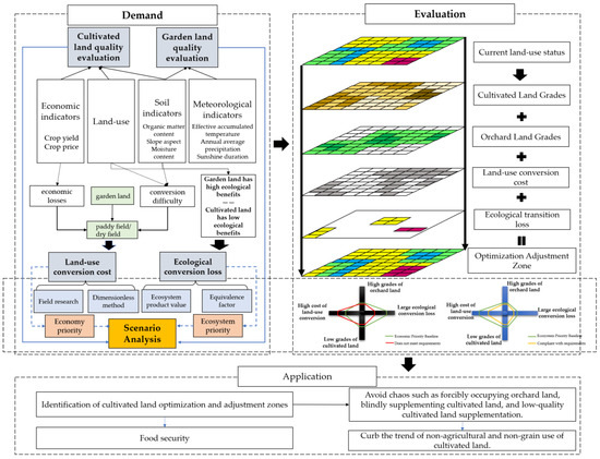
Figure 1.
Technology roadmap.
3. Research Area and Methods
This study links orchard land classification with cultivated land quality evaluation to support local governments in aligning orchard grading with cultivated land layout adjustment and the “requisition-compensation balance” policy. By comprehensively assessing economic and ecological losses during conversion, it balances economic development and ecological protection, proposing a scientific framework for identifying optimal cultivated land adjustment zones.
3.1. Study Area and Data Sources
The study area is located in Xinfeng County, Ganzhou City, Jiangxi Province, between 24°59′ N–25°33′ N and 114°34′ E–115°59′ E, a key town in southern Jiangxi adjacent to Guangdong Province. Its terrain features medium-low mountains in the east, south, and northwest, low hills in the southwest and north, and low hilly plains in the central region, sloping from south to north (Figure 2). Xinfeng County has a subtropical monsoon humid climate with a long frost-free period. It has diverse land structure types, with land use dominated by cultivated land and forest land. Orchard land has developed rapidly, primarily focused on fruit agriculture (navel oranges). As the birthplace of Gannan navel oranges, it has a 50-year history of navel orange cultivation.
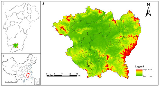
Figure 2.
Location of Xinfeng County.
All figures were produced on the basis of the Ministry of Natural Resources Standard Map Service System GS (2022) 1873 (http://bzdt.ch.mnr.gov.cn/ (accessed on 2 February 2024), with no modifications to the base map boundaries.
Data sources included the following:
Land-use data: Derived from a systematic field survey database conducted by local governments in 2020, this data has a high degree of consistency with the actual situation on the ground.
The DEM (Digital Elevation Model), NDVI (Normalized Difference Vegetation Index), and meteorological data were obtained from the Resource and Environmental Science and Data Center of the Chinese Academy of Sciences (http://www.resdc.cn/ (accessed on 2 February 2024), while the soil data was sourced from the Soil Science Data Center of the Nanjing Institute of Soil Sciences, Chinese Academy of Sciences (http://soil.geodata.cn (accessed on 2 February 2024), all with a resolution of 30 m.
Socioeconomic data: From China Statistical Yearbook 2023, National Compilation of Agricultural Product Cost and Benefit Data 2022, Jiangxi Province Soil and Water Conservation Bulletin, Jiangxi Statistical Yearbook, Xinfeng County Statistical Yearbook, Chronicle of Xinfeng Navel Oranges, Ganzhou City 2022 Statistical Bulletin on National Economic and Social Development, and China Fertilizer Network (http://www.fert.cn/11002/ (accessed on 2 February 2024).
Remote sensing images: Landsat 8 data (October–November 2020) from Google Earth Engine for water body identification.
3.2. Quality Evaluation of Orchard Land
The quality evaluation of orchard land serves as the foundation for the protection and rational utilization of orchard resources, and it is also a crucial measure to improve the classification, grading, and price evaluation system for natural resource assets. This study establishes an orchard land evaluation framework informed by the Code of practice for gradation and classification on orchard and perennial plantations (TD/T 1071-2022) [17] in China, with emphasis on natural quality of orchard land and adoption of a locally applicable classification scheme to enhance field applicability. Considering the need to integrate with actual conditions, this study selects the orchard plot data surveyed by the local government as the evaluation unit.
By collating previous achievements in orchard evaluation and the biochemical characteristics of citrus fruit trees, and in accordance with the Code of practice for gradation and classification on orchard and perennial plantations (TD/T 1071-2022), a total of 10 indicators were selected in conjunction with the opinions of ten experts and scholars from universities, local governments, and the China Land Survey and Planning Institute, to construct a quality evaluation index system for orchard land. This system aims to reflect the quality of citrus orchards from three dimensions: climate, soil, and topography. The analytic hierarchy process (AHP) [25,26] was used in combination with 72 farmer questionnaires to determine the index weights (Table 1).

Table 1.
Citrus orchard quality evaluation index system of Xinfeng County.
We obtain expert and farmer opinions through questionnaires, collecting factors that influence the quality of citrus orchards, to ensure that the indicator system reflects both scientific rigor and local practical experience. Using a stratified sampling approach, we first ranked townships by their orchard area proportion (township orchard area/total county orchard area). Townships with >5% orchard coverage contributed six sampling villages each, while those with <5% contributed three villages, yielding 72 candidate villages. To ensure spatial representativeness, grade inclusivity, and maximized orchard area coverage, village selection underwent optimization under the “Spatial distribution, Orchard grade, and Area ratio” (SGA) tri-criterion principle. This refined selection process resulted in 72 valid farmer questionnaires. By combining the reference indicators for garden land grading and evaluation in Jiangxi Province, the indicator system was determined.
We then constructed a hierarchical model including three criteria and ten sub-criteria. The weights of these three criteria and ten sub-criteria were determined through pairwise comparisons using the eigenvector method. We assessed the reliability of the AHP analysis by calculating the consistency ratio (CR). A CR value of 0 indicates complete consistency, while higher values reflect increasing inconsistency. If CR ≤ 0.10, the pairwise comparison matrix is considered to have acceptable consistency; otherwise, the matrix needs to be reconstructed. The criteria weights were obtained by normalizing the eigenvector. The final weights of the sub-criteria were calculated by multiplying the local weights of each sub-criterion by the global weight of its parent criterion. Ultimately, the weights of the indicators for evaluating the quality of citrus garden land in Xinfeng County were determined through a random consistency test (CR ≤ 0.021).
By referencing the index grading methods in relevant literature and incorporating the local characteristics of Xinfeng County, the indicators were classified into 3–5 grades, with scores of 100, 80, 60, 40, and 20 assigned from highest to lowest, forming the quality evaluation index system for orchard land in Xinfeng County. Using this framework, a weighted summation method was applied to compute the comprehensive quality scores for all evaluation units of orchard land in Xinfeng County. The natural breakpoint method was then applied to divide the comprehensive scores into six grades, resulting in the quality classification of citrus orchard land in Xinfeng County. Specifically, Grade 1 represents the highest quality orchard land, while Grade 6 denotes the lowest. The citrus orchard land in Xinfeng County is categorized into high-quality land (Grades 1–2), medium-quality land (Grades 3–4), and low-quality land (Grades 5–6).
3.3. Quality Evaluation of Cultivated Land
The classification of cultivated land quality grades is a rating system developed from the perspective of agricultural production. It evaluates the ability of cultivated land fertility, soil health status, and field infrastructure to sustain agricultural product output and quality safety through a comprehensive index method.
This study utilizes the Google Earth Engine (GEE) platform and Landsat 8 imagery data, and applies JavaScript to process the imagery through cloud removal, image fusion/mosaicking, and image clipping. A random forest classification algorithm was applied to identify the main rivers, lakes, reservoirs, and other water bodies in Xinfeng County in 2020. ArcGIS is then utilized to create 1 km and 0.5 km buffer zones for major rivers and small water bodies, respectively, designating these as areas suitable for paddy field conversion with abundant water resources. The result of overlaying these buffer zones with orchard patches is defined as the final paddy field potential development area, while other patches are designated as dryland potential development areas. The study finds that the paddy field potential development areas in Xinfeng County are mainly distributed in the central plain region, whereas the dryland potential development areas are primarily located in the surrounding mountainous areas.
The cultivated land quality evaluation work in Xinfeng County classifies cultivated land into two categories—paddy fields and dry land—to assess the quality level of cultivated land. The Delphi method was employed to determine the weights of evaluation indicators, and ultimately, the cultivated land quality evaluation indicators and weights for Xinfeng County were obtained (Table 2). The Delphi panel consisted of 23 experts and scholars from relevant fields, affiliated with institutions including China Agricultural University, China University of Geosciences (Beijing), Jiangxi Agricultural University, and Chinese Academy of Land Surveying and Planning. These experts conducted anonymous scoring on the weights of the selected indicators. The scores were then aggregated, summarized, and subjected to quantitative statistical analysis before being sent back to each expert, with each member receiving copies of the questionnaire results. This process was conducted over three rounds, ultimately determining the weights of evaluation indicators for cultivated land quality in Xinfeng County. The evaluation parameter system and indicator scoring rules were determined based on the cropping system issued by the national classification of cultivated land resource quality and the light-temperature production potential index and yield ratio coefficient adjusted according to the “Third National Land Survey” (Table 3). In the national standard farming system zoning, Jiangxi Province is divided into four standard farming system zones, among which Xinfeng County is located in the eastern hilly mountainous zone, which follows a double cropping system annually. The benchmark crop is early rice, and the designated crops are early rice, late rice, dry land rapeseed, and peanut.

Table 2.
Cropland quality evaluation indicators and weights.

Table 3.
Evaluation parameter system of Xinfeng County.
With reference to the Regulation for gradation on agriculture land quality, the adjusted evaluation parameters and indicator system were applied to calculate the cultivated land quality grades for orchard map patches in Xinfeng County. Among them, based on the local actual land use and economic development conditions, the land-use coefficients and land economic coefficients for different crops in Xinfeng County were calculated, and the land economic grade index was selected as the final cultivated land grade score. The cultivated land grades are divided with a grade difference of 200 economic grade indices. Nationally, cultivated land is classified into fifteen grades in total, where Grade 1 represents the highest quality cultivated land and Grade 15 represents the lowest quality. Nationwide, cultivated land is divided into superior land (Grades 1–4), high-quality land (Grades 5–8), medium-quality land (Grades 9–12), and low-quality land (Grades 13–15). The grades of potential cultivated land optimization and adjustment zones in Xinfeng County’s orchard land are concentrated between Grade 7 and Grade 13.
3.4. Land-Use Conversion Cost
When converting orchard land to cultivated land, the main crops are shifted from citrus to dryland crops such as rapeseed and peanuts, and paddy crops like rice, leading to an overall decline in economic benefits. Additionally, on steep slopes, the construction of terraces necessitates significant earthwork, resulting in high costs. Meanwhile, the area of cultivable land of the completed terraces is small. Terrace construction can also damage vegetation and even the original stable terrain, and is prone to causing soil erosion and triggering geological disasters such as landslides and debris flows, which can disrupt local biodiversity. On the other hand, regarding the difficulty of remediation from orchard to cultivated land, the attributes of “easily restorable” and “engineerably restorable” indicate low conversion difficulty and minimal damage to existing infrastructure and plough layers.
Therefore, the cost factors for land type conversion consist primarily of three components: slope, remediation attributes, and the corresponding crop output value loss, as expressed by the following formula:
Among them,
refers to the total loss per unit area when converting orchard land to cultivated land;
refers to the standardized result of economic loss per unit area when converting orchard land to cultivated land;
refers to the slope coefficient of land type conversion difficulty;
refers to the land remediation coefficient of land type conversion difficulty.
In the process of converting orchards to cultivated land, with reference to China’s national standard Technical regulation of the third nationwide land survey (TD/T 1055-2019) [27], the restoration attributes are classified into three categories based on the degree of damage to the plough layer and the difficulty of implementing engineering measures: “immediately restorable,” “engineerable restorable,” and others (serious damage to the plough layer, high engineering restoration costs). The remediation attribute coefficients are assigned values of 0.5, 0.8, and 1, respectively. According to the Technical specification for engineering construction of terrace on slope land (DB 13/T 2019-2014) [28], different slope coefficients are assigned to different slope ranges to indicate the degree of influence of slope factors in land type conversion. The economic loss of agricultural land conversion is mainly reflected in the change in output value after crop replacement. This study reflects the economic loss of agricultural land conversion by calculating the difference between the output value of citrus in orchard land and the total output value of standard cultivated crops in potential cultivated land.
Considering the different units and incomparable numerical values among different factors, this study standardizes the slope, remediation attributes, and corresponding crop output value loss of land type map patches [29,30]. A series of values ranging from 0 to 1 in the study area are finally obtained as the land type conversion cost, indicating the economic difficulty level of land type conversion.
3.5. Ecological Conversion Loss Model
Ecological environment damage refers to adverse changes in environmental elements such as the atmosphere, water, and soil, as well as biological elements such as animals and plants, caused by environmental pollution or ecological destruction, and refers to the degradation of ecosystem functions composed of the above elements. When orchards are converted to cropland, the ecological environment sustains substantial damage and the biological environment undergoes significant changes. Therefore, this paper employs the standardized difference between the gross ecosystem product (GEP) of orchards and croplands as the ecological conversion loss [31,32,33,34]. Additionally, although food production is one of the important service functions of ecosystems, the value of food production has already become a core component of the economic losses in land-use conversion costs, directly quantifying the economic trade-offs of crop outputs during the conversion process, which has been obtained through economic calculations. Therefore, to avoid the error of food production being counted repeatedly, it is not included in the calculations of this section.
3.5.1. Ecosystem Service Values of Orchards
According to the actual situation and characteristics of citrus orchards in Xinfeng County, and based on the ecosystem service classification method proposed by the Millennium Ecosystem Assessment Framework Working Group and the ecological product value accounting system proposed by Ouyang Zhiyun et al. [35,36,37], seven key regulating service functions supporting the formation of ecological products in citrus orchards were selected, including water conservation, water quality purification, carbon fixation and oxygen release, soil conservation, nutrient cycle maintenance, environmental purification, and climate regulation. A gross ecosystem product (GEP) accounting system for citrus orchards in Xinfeng County was constructed [38,39,40]. The gross ecosystem product of citrus orchards in Xinfeng County was calculated based on the area of each orchard patch and the corresponding unit ecosystem service value, with the formula as follows:
: The gross ecosystem product per unit area of citrus orchard land (yuan/hm2·a−1) [41,42,43];
: Value of water conservation per unit area of citrus orchard land (yuan/hm2·a−1);
: Value of hydrological regulation per unit area of citrus orchard land (yuan/hm2·a−1);
: Value of carbon fixation per unit area of citrus orchard land (yuan/hm2·a−1);
: Value of oxygen release per unit area of citrus orchard land (yuan/hm2·a−1);
: Value of soil retention per unit area of citrus orchard land (yuan/hm2·a−1);
: Value of nutrient cycle maintenance per unit area of citrus orchard land (yuan/hm2·a−1);
: Value of SO2 absorption per unit area of citrus orchard land (yuan/hm2·a−1);
: Value of dust retention per unit area of citrus orchard land (yuan/hm2·a−1);
: Value of temperature reduction in orchard land (yuan/hm2·a−1);
: Value of humidity increase in orchard land (yuan/hm2·a−1).
3.5.2. Ecosystem Service Values of Croplands
The ecosystem service values of cultivated land in this study are the average ecosystem service values calculated based on simulations of potential paddy fields and dry land. Using Xie Gaodi’s equivalent factor method [44], the equivalent values of various ecosystem services for different land types were determined, and the total equivalents of seven ecosystem services—water resource supply, gas regulation, climate regulation, environmental purification, hydrological regulation, soil conservation, and nutrient cycle maintenance—were obtained for three land types: dry land, paddy fields, and broad-leaved forests. Since citrus orchards belong to evergreen broad-leaved forests, this study uses the equivalent values of broad-leaved forests to replace those of orchard land. On this basis, considering potential differences in ecological benefits between plots, this study employs the equivalent ratio of orchard land to cultivated land as a conversion coefficient to estimate the ecosystem service values of plots after “orchard-to-cultivated land conversion” in different regions.
In the formula:
: The gross ecosystem product per unit area of dry land (yuan/hm2·a−1);
: Total equivalent of ecological service value for dry land (yuan/hm2·a−1);
: Total equivalent of ecological service value for orchard land (yuan/hm2·a−1);
: The gross ecosystem product per unit area of citrus orchard land (yuan/hm2·a−1);
: The gross ecosystem product per unit area of paddy field (yuan/hm2·a−1);
: Total equivalent of ecological service value for paddy field (yuan/hm2·a−1).
3.5.3. Ecological Conversion Loss
The ecological conversion loss is expressed as the difference between the gross ecosystem product of orchards and that of cultivated land, with the calculation formula as follows:
In the formula:
: The standardized result of ecological loss per unit area when converting orchard land to cultivated land;
: The maximum ecological loss per unit area when converting orchard land to cultivated land (yuan/hm2·a−1);
: The ecological loss per unit area when converting orchard land to cultivated land (yuan/hm2·a−1);
: The minimum ecological loss per unit area when converting orchard land to cultivated land (yuan/hm2·a−1).
4. Scenario Setting for Identification of Cultivated Land Optimization and Adjustment Zones
The primary distinction among scenarios in this study lies in the varying sizes of cultivated land optimization and adjustment zones, reflecting quantitative protection of cultivated land. Additionally, the selection of three evaluation dimensions—orchard land quality, cultivated land quality, and ecological benefits—integrates the dual protection objectives of quality and ecological conservation. From a “trinity” perspective integrating quantity, quality, and ecology, three scenarios are formulated by synthesizing economic interests to explore the identification of cultivated land optimization and adjustment zones under varying contextual conditions.
4.1. GS: General Scenario
Based on the current cultivated land subsidy policies in Xinfeng County, and referencing the published policies on converting forestland back to cultivated land in Miyun District, Beijing, and combining the per capita income differences between the two regions, the minimum subsidy standard for “converting orchard land to cultivated land” was determined to be CNY 112 per mu, and the maximum subsidy standard to be CNY 1737 per mu. In this study, based on the evaluation of orchard land and cultivated land, orchard areas with lower orchard evaluation grades and higher cultivated land evaluation grades were selected as target areas for the development of cultivated land optimization and adjustment zones aiming to maximize the efficient use of land.
In practice, due to the influence of slope, cultivated land with a steeper gradient is often unfavorable for cultivation. On the one hand, it is not conducive to the widespread application of mechanized farming, and on the other hand, it may exacerbate ecological issues such as soil erosion. Therefore, slope is often considered the primary condition by the government when developing and utilizing cultivated land. In the process of evaluating the quality of garden land and cultivated land, the “slope” indicator has been used. In the calculation of land-use conversion costs, different slope coefficients have also been assigned based on different slopes. Therefore, to highlight the advantages of contrasting the economic priority scenario and the ecological priority scenario, this study selects the slope as the primary reference factor under general conditions [21], to simply simulate the government’s tendency to choose cultivated land optimization and adjustment zones in typical situations. On this basis, according to the quality grades of orchard land and cultivated land, the scenarios are divided into four types: ① Conversion of medium and low-grade orchard land to medium and high-grade cultivated land, abbreviated as MM (medium-medium); ② Conversion of low-grade orchard land to high-grade cultivated land, abbreviated as LH (lower-high); ③ Conversion of low-grade orchard land to medium and high-grade cultivated land, abbreviated as LM (lower-medium); ④ Conversion of medium and low-grade orchard land to high-grade cultivated land, abbreviated as MH (medium-high).
4.2. EM: Economic Priority Scenario
In this scenario, ecological benefits are subordinated to economic benefits, without considering the magnitude of ecological conversion losses. Based on existing cultivated land subsidies, economic benefits are maximized. Therefore, the ecological conversion loss factor assumes values ranging from the minimum to the maximum (0–1). To reduce government expenditure and compensate farmers for appropriate economic losses, the land-use conversion cost factor assumes values ranging from the minimum to the ratio of the minimum subsidy standard for “orchard-to-cultivated land conversion” to the maximum economic loss (0–0.023).
4.3. EG: Ecological Priority Scenario
In this scenario, priority is given to minimizing the impact on ecological benefits, while considering the limitations of government subsidies; damage to economic benefits is required to be controlled within a certain range. Therefore, areas with ecological losses above the average are designated as non-development zones. These areas account for more than 80% of the orchard land area in Xinfeng County, and they typically exhibit higher natural connectivity and more significant ecological values, effectively ensuring that the ecological benefits of orchard land are maintained. Thus, the ecological conversion loss factor is assigned a range of 0–0.094. To minimize economic losses, the government subsidy value is maximized based on actual fiscal revenue and expenditure conditions. Therefore, the land-use conversion cost factor assumes values ranging from the minimum to the ratio of the maximum subsidy standard for “converting orchard land to cultivated land” to the maximum economic loss (0–0.357).
5. Results
5.1. Comparative Analysis of Cultivated Land and Orchard Land Quality Evaluation
The quality grades of orchard land in Xinfeng County range from Grade 1 to Grade 6, with an overall moderately high level, predominantly comprising Grade 3 and Grade 4 lands, exhibiting a normal distribution. Specifically, the area of Grade 3 orchard land is 2738.23 hectares, accounting for 22.99%; the area of Grade 4 orchard land is 3482.97 hectares, accounting for 29.24%, with the combined total representing approximately 52.23% of the total orchard land area in Xinfeng County. Grade 1 orchard land is primarily distributed in the northern low mountain and hilly areas and the central low mountain plains. Grade 2 orchard land is distributed throughout the entire region of Xinfeng County. Grade 3 orchard land has the largest distribution area in Xinfeng County, being primarily concentrated in the central low mountain plains. Grade 4 orchard land is relatively evenly distributed across Xinfeng County. Grade 5 orchard land is primarily concentrated in the northwestern and northeastern regions of Xinfeng County. Grade 6 orchard land is primarily concentrated in the southwestern and eastern regions of Xinfeng County (Figure 3).
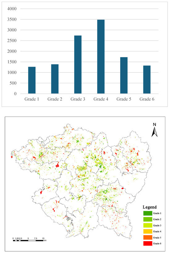
Figure 3.
Quantity and geographic distribution of orchard land quality evaluation.
The quality grades of all potential cultivated land in Xinfeng County range from Grade 7 to Grade 10 and from Grade 12 to Grade 13, with Grade 8 being the most prevalent. Dry land is entirely distributed in Grades 12 and 13, while paddy fields are exclusively located in Grades 7 to 10. The area of Grade 8 cultivated land is 8636.49 hm2, accounting for 72.5% of the total cultivated land area. High-grade cultivated land in Xinfeng County is primarily distributed in the central plain area, with a small portion of high-quality cultivated land scattered in the surrounding mountainous areas, most of which are classified as Grade 8. Low-grade cultivated land is mainly distributed in the mountainous areas of the southern and northeastern regions, with the majority of these lands classified as Grade 13 (Figure 4).
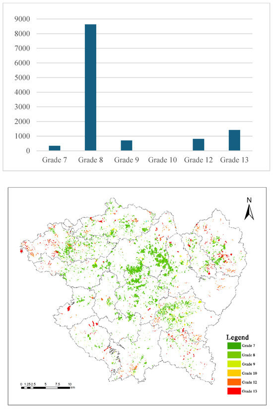
Figure 4.
Quantity and geographic distribution of potential cultivated land quality evaluation.
Without considering other factors, the existence of some map units where the quality of cultivated land is significantly higher than that of orchard land indicates considerable potential for converting orchard land to cultivated land based on natural background conditions. When all orchard land is converted to cultivated land, 4978.54 hm2 of land are converted from Grade 3 or 4 orchard land to Grade 8 cultivated land, accounting for 41.84% of the total area of orchard map units. This indicates that medium-quality orchard land can be converted into medium-quality cultivated land in substantial quantities, effectively compensating for cultivated land losses and contributing to food security through rational land-use conversion. In addition, 1719.95 hm2 of low-quality orchard land can be converted into medium-to-high-quality cultivated land, accounting for 14.46% of the total area of map units (Figure 5). The reclamation and development of this low-quality orchard land should form the core of cultivated land optimization and adjustment. This approach can not only safeguard the quantity of cultivated land and increase grain production but also prevent excessive harm to the interests of farmers and local governments, ensuring the concurrent development of food security and economic benefits. It provides a fundamental basis for the subsequent proposal of multi-dimensional evaluations to identify cultivated land optimization and adjustment zones.
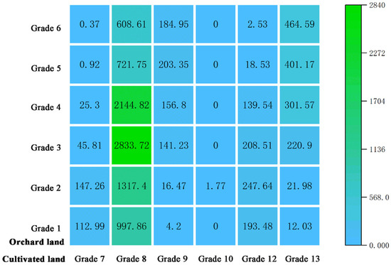
Figure 5.
Transfer matrix of the garden cultivated land quality levels.
The comprehensive scores of cultivated land quality are compared with those of orchard land quality. Areas with higher cultivated land quality are designated as potential cultivated land zones, while areas with higher orchard land quality are designated as potential orchard land zones (Figure 6). A total of 6652.21 hm2 of map units show changes within the range of ±10 points, indicating minor differences between the quality grades of orchard land and cultivated land. This suggests that through rational land-use conversion, the fundamental land quality can be maintained, providing a precondition for the identification of cultivated land optimization and adjustment zones. There are 7973.37 hm2 of map units where the grade of orchard land is higher than that of cultivated land, accounting for 67.01% of the total area of map units, indicating that most map units in Xinfeng County are more suitable for cultivating orchard crops such as citrus. Overall, only 748.46 hm2 of map units exhibit changes in the quality of cultivated land and orchard land by more than four grades, accounting for 6.29% of the total area of map units, suggesting that the quality evaluation criteria for orchard land and cultivated land are generally consistent, with few areas where cultivated land is of extremely high quality while orchard land is of extremely low quality, or vice versa.
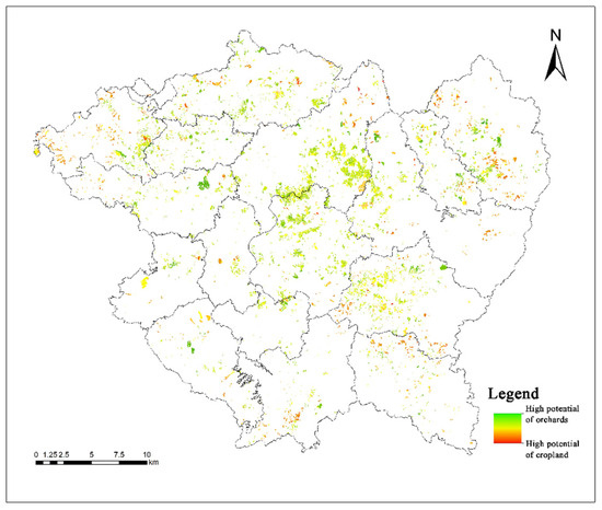
Figure 6.
Comparison of the quality potential of orchard land and cultivated land.
5.2. Comparative Analysis of Land-Use Conversion Cost and Ecological Conversion Loss
As shown in Figure 7, land-use conversion costs in the northern mountainous areas are generally low, which is consistent with the spatial distribution of orchard land output value. The higher the orchard land output value in a region, the higher the corresponding land-use conversion cost. Consequently, the land-use conversion costs in the eastern and southeastern regions are significantly higher than those in other areas. Meanwhile, land-use conversion costs in the central plain area are also relatively low, which may be attributed to topographic slope factors, as flatter areas incur lower conversion costs. In Xinfeng County, 83% of orchard land has a land-use conversion cost below 0.3, indicating that overall, most of the orchard land exhibits relatively low conversion costs. Under favorable economic conditions, large-scale conversion is feasible.
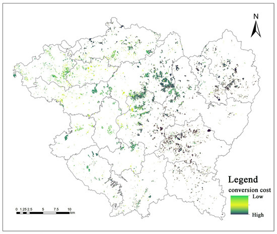
Figure 7.
Distribution of land-use conversion costs in Xinfeng County.
The GEP of citrus orchard land in Xinfeng County is estimated at CNY 270 million·a−1. Among these, soil conservation services contribute the most (32.52%), followed by carbon sequestration and oxygen release (28.81%), indicating that the primary ecological contributions of orchard trees stem from their functions in soil retention and carbon sequestration–oxygen release. Overall, the unit GEP of citrus orchards in Xinfeng County reflects topographical patterns, exhibiting higher values in peripheral areas and lower values in the central region, with a decreasing gradient from high to low altitudes. Significant spatial heterogeneity exists among individual GEPs of citrus orchards in Xinfeng County, with varying synergistic and trade-off relationships at the plot level, which are not always mutually reinforcing (Figure 8).
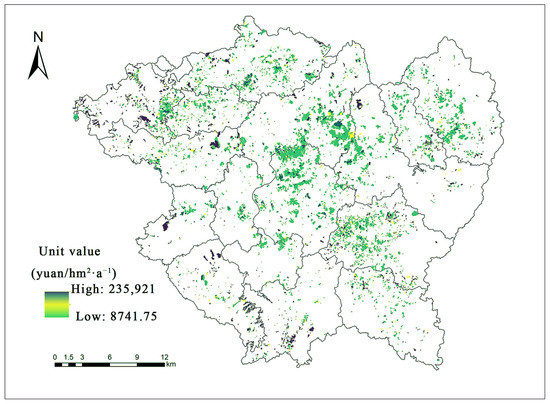
Figure 8.
Spatial distribution of gross ecosystem product of citrus orchards.
The ecological conversion loss in Xinfeng County shows a spatial pattern of higher values in peripheral areas and lower values in the central region (Figure 9). Overall, spatial differences across the county are relatively small. Farmland plots near mountainous areas experience higher ecological conversion losses, consistent with natural conditions. Meanwhile, some plots in the central plain area exhibit higher ecological conversion losses, possibly due to their high degree of land-use agglomeration. In Xinfeng County, 76% of orchard land has an ecological conversion loss below 0.1, while less than 1% exceeds 0.3. Overall, most of the orchard land in Xinfeng County incurs low ecological conversion losses. When necessary, retaining only orchard land with highly significant ecological conservation functions while converting the remainder into cultivated land would not result in irreparable ecological damage.
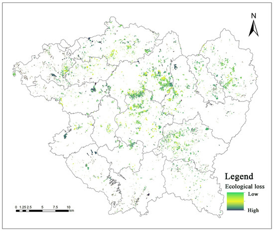
Figure 9.
Spatial distribution of ecological conversion losses.
In Xinfeng County, 70% of orchard land has a land-use conversion cost exceeding the ecological conversion loss, mainly concentrated in the central and eastern regions (Figure 10). This suggests that the impact on local economic benefits may be more pronounced when developing cultivated land optimization and adjustment zones.
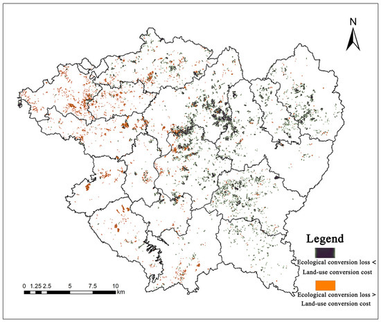
Figure 10.
Spatial comparison of economic and ecological benefits of gardening in Xinfeng County.
6. Identification Results of Cultivated Land Optimization and Adjustment Zones
6.1. Analysis of Results in Each Scenario
In the general scenario, the optimization and adjustment zone under the GS situation covers the largest area, measuring 1395.78 hm2, accounting for 11.7% of the total orchard land (Figure 11). It is primarily distributed in the northwestern region of Xinfeng County. Influenced by topographic slope factors, these plots are generally located near towns and concentrated in flat plain areas (Figure 12). This indicates that centralized development of optimization and adjustment zones in the northwestern region can both preserve high-quality orchard land and identify high-quality cultivated land by making full use of plain areas. Differences exist in total ecological and economic value losses across scenarios, decreasing in the order of GS, MMGS, MHGS, LMGS, and LHGS. In particular, both ecological and economic losses in the LHGS scenario are less than one-fifth of those in the GS scenario, representing a substantial difference.
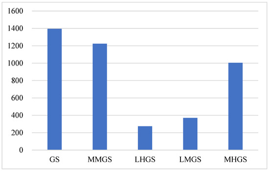
Figure 11.
Area of GS cropland optimization and adjustment zone.
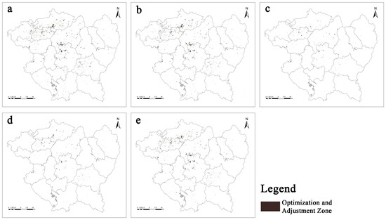
Figure 12.
Spatial distribution of GS cropland optimization and adjustment zones. Note: These maps represent the spatial distribution of cultivated land optimization and adjustment zones identified under five modes in the general scenario. (a) GS; (b) MMGS; (c) LHGS; (d) LMGS; (e) MHGS.
In the economic priority scenario, the optimization and adjustment zone under the MMEM situation covers the largest area, measuring 786.85 hm2, accounting for 6.6% of the total orchard land (Figure 13). It is mainly concentrated in the northwestern region of Xinfeng County (Figure 14). Therefore, centralized development of optimization and adjustment zones in the northwestern region can help minimize economic benefit losses. Total ecological and economic value losses also decrease in the order of MMEM, MHEM, LMEM, and LHEM. In particular, ecological loss in the LHEM scenario is less than one-fourth of that in the MMEM scenario, representing a substantial difference.
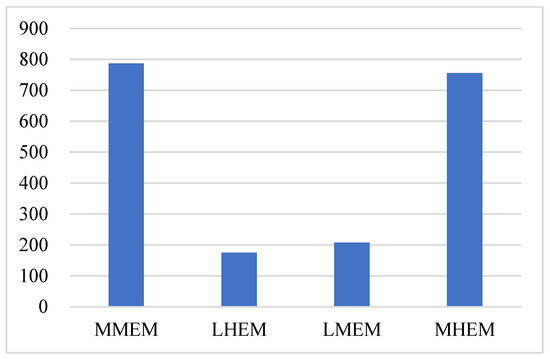
Figure 13.
Area of cropland optimization and adjustment zones in the economic priority scenario.
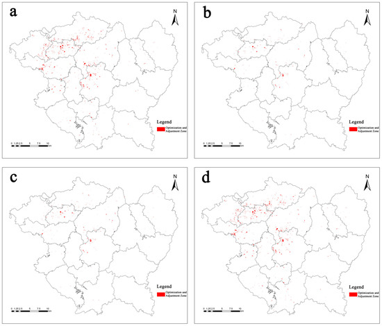
Figure 14.
Spatial distribution of cropland optimization and adjustment zones in the economic priority scenario. Note: These maps represent the spatial distribution of cultivated land optimization and adjustment zones identified under four modes in the economic priority scenario. (a) MMEM; (b) LHEM; (c) LMEM; (d) MHEM.
In the ecological priority scenario, the optimization and adjustment zone under the MMEG scenario covers the largest area, measuring 5139.26 hm2, accounting for 43.14% of the total orchard land (Figure 15). Centralized development of optimization and adjustment zones in the mid-northern region of Xinfeng County can substantially minimize ecological benefit losses (Figure 16). In the LHEG scenario, the optimization and adjustment zone is the smallest, covering only 766.79 hm2 (6.44% of the total orchard land), indicating that under the ecological priority strategy, the development direction has shifted to the mid-northern and northeastern regions. Compared with the LHEG scenario, the MMEG scenario demonstrates that differences in orchard land grades greatly influence the selection scope of cultivated land optimization and adjustment zones—the area difference is nearly seven-fold—but exert little impact on the overall distribution trend. Total ecological and economic value losses also decrease in the order of MMEG, MHEG, LMEG, and LHEG. In particular, ecological loss in the LHEG scenario is less than one-sixth of that in the MMEG scenario, representing a substantial difference.
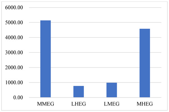
Figure 15.
Area of cropland optimization and adjustment zones for ecological priority scenarios.
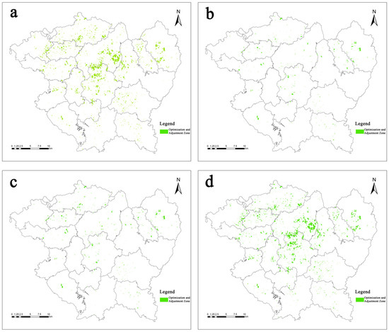
Figure 16.
Spatial distribution of cultivated land optimization and adjustment zones in the ecological priority scenario. Note: These maps represent the spatial distribution of cultivated land optimization and adjustment zones identified under four modes in the ecological priority scenario. (a) MMEG; (b) LHEG; (c) LMEG; (d) MHEG.
6.2. Comprehensive Analysis of Scenarios
In all scenarios, the optimization and adjustment zone under the MMEG scenario has the largest area, covering 5139.26 hm2 of orchard land available for conversion into cultivated land. In contrast, the zone under the LHEM scenario has the smallest area, with only 174.79 hm2 of orchard land suitable for conversion. The difference between the two is nearly thirty-fold, indicating a substantial disparity in usable land resources. Meanwhile, the optimization and adjustment zones identified under the ecological priority scenario are consistently larger than those under the economic priority scenario, suggesting that economic constraints, rather than the current ecological condition of orchard land, are the primary factors limiting land-use conversion.
In the LH and LM scenarios (i.e., LHGS, LHEM, LHEG, LMGS, LMEM, LMEG), the area of cultivated land optimization and adjustment zones is consistently below 1000 hm2, which is significantly lower than that in the MM and MH scenarios (MMGS, MMEM, MMEG, MHGS, MHEM, and MHEG) as well as in the GS scenario (Figure 17). This suggests that orchard land grade exerts a substantial influence on the identification of cultivated land optimization and adjustment zones. The predominance of medium-grade orchard land, typically associated with relatively low ecological value, may explain this outcome.
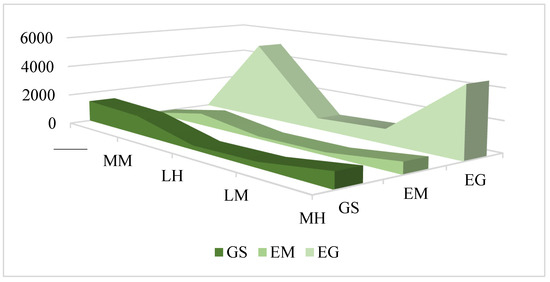
Figure 17.
Comparison of the area of optimized cropland adjustment zones in different scenarios.
In both the economic priority scenario and ecological priority scenario, all results outperform those in the general scenario, indicating that the model application facilitates more efficient identification of optimization and adjustment zones. Regarding ecological loss, the GS and MMGS scenarios exhibit the highest unit ecological loss, each measuring 0.069 (Figure 18). Unit ecological loss in the economic priority scenario is slightly lower than in the general scenario overall, yet 0.004–0.013 higher than in the ecological priority scenario, indicating significant differences. Concerning economic loss, the LHEG scenario presents the highest unit economic loss, reaching 0.153 (Figure 19). Unit economic loss in the ecological priority scenario is substantially higher than in other scenarios, averaging over ten times that in the economic priority scenario and seven times that in the general scenario, demonstrating highly significant differences.
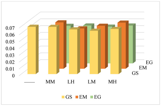
Figure 18.
Comparison of ecological losses per unit for different scenarios.
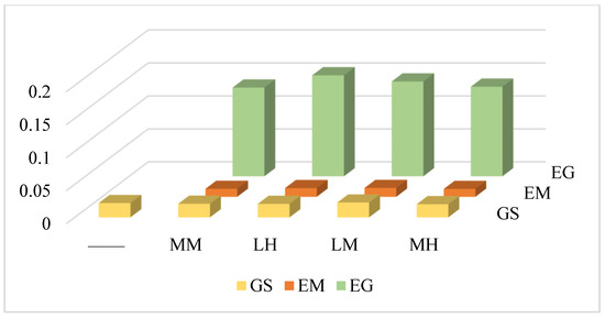
Figure 19.
Comparison of economic losses per unit for different scenarios.
7. Discussion and Conclusions
Theoretically, this study integrates the quality evaluation of orchard and cultivated land, constructing a multi-dimensional analytical framework that addresses the gap between “single-factor” approaches (e.g., considering only slope) and “comprehensive evaluation” in agricultural land conversion research. This framework further enriches the theoretical basis for land-use optimization by quantifying the trade-offs between economic and ecological benefits during land conversion.
Practically, this framework provides a tool for local governments to implement the strategy of “moving orchards to the mountains and cultivated land to the plains,” thereby reducing the gap between policy design and local implementation. The identified optimized adjustment zones, particularly under the MMEG and MMEM scenarios, ensure that the quality of converted cultivated land complies with standards while minimizing economic losses and ecological impacts, addressing practical concerns such as “blind conversion” and “low-quality supplementary cultivated land.”
Economically, the conversion of medium-low-grade orchard land to medium-high-grade cultivated land prevents the large-scale loss of high-grade orchards, which substantially contribute to local income. Medium-low-grade orchards, owing to their lower output value, can be converted into medium-high-grade cultivated land, thereby maintaining food production capacity. Conversion costs are significantly lower than those for high-grade orchards, which can mitigate economic fluctuations and ensure stable farmer incomes during the “fruit-to-grain” transition. Ecologically, medium-low-grade orchards possess substantially lower ecosystem service values compared with high-grade orchards, and their conversion exerts a relatively minor impact on the ecosystem. Additionally, medium-high-grade cultivated land is typically located on plains, where interventions such as irrigation and vegetation restoration can improve water retention and carbon sequestration, partially offsetting ecological losses and achieving a balance between land conversion and environmental protection.
7.1. Policy Recommendations
Priority should be given to the development of orchard land with high paddy field potential, particularly in regions with biophysical conditions similar to Xinfeng County (e.g., subtropical hilly areas with abundant water resources). Orchard land with high paddy field potential is generally located in plain areas close to water sources and with flat terrain. On the one hand, human activities are more frequent and intensive in plain areas, and the level of mechanized farming is higher, resulting in relatively low resource consumption during the conversion of orchard land to cultivated land. On the other hand, the output value of paddy fields is higher than that of dry land, with smaller losses in economic benefits, which also guarantees the comprehensive economic income of farmers. Through effective government guidance, farmers can more quickly accept policy adjustments. Developing orchard land with high paddy field potential is also a feasible path to implement the national strategy of “moving orchards to mountains and cultivated land to lowlands.” However, its applicability in arid, cold, or areas with significant terrain differences still needs further verification.
Cities with different development demands can select and adjust scenario models according to their needs. Cities dominated by ecological benefits, especially those in ecologically sensitive areas, need to prioritize the protection of soil conservation and nutrient cycling services during the identification of optimization and adjustment zones. Cities dominated by economic benefits, especially those with high agricultural intensification and well-developed irrigation facilities, should preferentially select flat orchard lands with remediation attributes of “recoverable” or “engineered recovery” as optimization and adjustment zones.
Application of the Optimization and Adjustment Zone Identification Model. As an ecosystem itself, land is formed by the coupling of the land ecological system and the land economic system through mutual interaction, penetration, and interweaving in a specific space. Especially for agricultural land, ecological and economic benefits must go hand in hand with natural attributes. In the implementation of the cultivated land requisition–compensation balance policy, the optimization and adjustment area identification model proposed in this paper can serve as a reference framework. However, its parameters (such as the ecosystem services) need to be locally calibrated based on regional biophysical differences (such as climate and soil) and socio-economic characteristics (such as crop prices and labor costs). Through localized adjustments, it is possible to enhance the quantity and quality of cultivated land while minimizing the gains and losses of other agricultural land, reinforcing the principle of “suitable for grain, then grain; suitable for cash crops, then cash crops.” This will better serve the strategic goal of “moving orchards to mountains and cultivated land to lowlands” in areas with conditions similar to Xinfeng County.
7.2. Limitations and Future Prospects
This study adopts 2020 as the base period data, which is the latest legally obtainable data at the time of the study. However, due to the confidentiality and acquisition difficulty of the land change data in Xinfeng County, we lack long-term monitoring data, and thus were unable to explore inter-annual changes, which poses certain limitations in the temporal aspect of the study data.
In addition, although long-term climate and market conditions may fluctuate, due to Xinfeng County being a typical hilly mountainous agricultural county, its land-use structure has been long constrained by natural factors such as topography (hilly basins and medium-low mountain high hills) and climate conditions (subtropical monsoon humid climate). These constraints have not fundamentally changed in the short term. As the core research subject, citrus orchards depend on stable factors such as soil texture, slope orientation, and climate, which remain largely stable over 3–5 years. In terms of socio-economic data, Xinfeng County’s navel orange industry primarily consists of perennial fruit trees with a planting cycle of 7–8 years, making it relatively stable in the short term. Therefore, this study aims to provide a reference framework for converting orchard land to cultivated land, rather than a fixed and precise conversion plan. The identified optimization adjustment zones are intended to provide a flexible range for local governments and stakeholders to adjust their decisions based on specific development goals (such as short-term economic benefits or long-term ecological protection) and real-time conditions. Consequently, the study results are intentionally kept general to adapt to the flexibility required in practical applications, thereby reducing the necessity for strict sensitivity testing, which introduces certain limitations.
Future research can apply the methodological framework proposed in this study to other types of gardens or similar ecological zones, by adjusting parameters, to validate its applicability in different crop types and climate zones, thereby forming a replicable framework for identifying cultivated land optimization and adjustment zones. It can also introduce long-term sequential data to analyze dynamic change patterns. By integrating data on crop yields, market prices, meteorological data (such as extreme precipitation and temperature fluctuations), and ecosystem service monitoring from Xinfeng County over the past 10 years, a dynamic evaluation model can be constructed to quantify the economic costs and ecological losses of converting orchards to cropland over different years, revealing the spatiotemporal evolution characteristics of the conversion zones, and providing more precise basis for long-term land-use planning.
7.3. Research Conclusions
This paper develops an identification model for cultivated land optimization and adjustment zones through analyses of four dimensions: orchard land classification evaluation, cultivated land classification evaluation, economic benefit analysis, and ecological benefit analysis. The study reached the following conclusions:
- Compared to the general scenario that only considers slope, using the identification model for cultivated land optimization and adjustment zones results in fewer economic and ecological losses. Meanwhile, it ensures that most adjusted plots have small slopes, which not only safeguards local ecological and economic benefits but also maximizes the suitable development of low-slope agricultural land, actively responding to the policy guidance of “relocating orchards to mountains and cultivated land to lowlands.”
- For cities prioritizing ecological environment development, adopting strategies under the ecological priority scenario can maximize the protection of the local ecological environment. The unit ecological loss is the lowest under the LMEG scenario, and cultivated land development following this scenario can maximize the protection of the local ecological environment from being damaged. Under the MMEG scenario, the area of cultivated land optimization and adjustment zones is the largest, which can provide a large amount of cultivated land resources and is conducive to the realization of the national food security strategy.
- For cities prioritizing economic development, adopting strategies under the economic priority scenario can maximize the smooth transition of local economic levels and achieve a dual balance between the economic benefits of orchard land and cultivated land demand. Under the LMEM scenario, the unit economic loss is the lowest. Cultivated land development following this scenario can maximize the protection of the local orchard economy from being seriously affected. Under the MMEM scenario, the area of cultivated land optimization and adjustment zones is the largest, which can meet the demand for cultivated land and fill the gap in cultivated land resources.
Author Contributions
Conceptualization, Z.F. and K.W.; Methodology, Z.F., Z.L., H.G., G.C., W.P. and K.W.; Formal analysis, Z.F.; Writing—original draft, Z.F., Z.L., H.G. and W.P.; Writing—review & editing, Z.F.; Visualization, Z.L. and H.G.; Supervision, G.C. All authors have read and agreed to the published version of the manuscript.
Funding
This research was funded by [National Key R&D Program of China] grant number [2024YFD1600700] And The APC was funded by [2024YFD1600700].
Institutional Review Board Statement
Not applicable.
Informed Consent Statement
Not applicable.
Data Availability Statement
The original contributions presented in this study are included in the article. Further inquiries can be directed to the corresponding author.
Acknowledgments
Thank you to everyone who contributed to this study.
Conflicts of Interest
The authors declare no conflict of interest.
References
- Huddleston, J.H. Development and Use of Soil Productivity Ratings in the United States. Geoderma 1984, 32, 297–317. [Google Scholar] [CrossRef]
- Guo, L.; Sun, Z.; Ouyang, Z.; Han, D.; Li, F. A Comparison of Soil Quality Evaluation Methods for Fluvisol along the Lower Yellow River. CATENA 2017, 152, 135–143. [Google Scholar] [CrossRef]
- Fan, Y.; Zhang, C.; Hu, W.; Khan, K.S.; Zhao, Y.; Huang, B. Development of Soil Quality Assessment Framework: A Comprehensive Review of Indicators, Functions, and Approaches. Ecol. Indic. 2025, 172, 113272. [Google Scholar] [CrossRef]
- Baoua, I.B.; Amadou, L.; Bakoye, O.; Baributsa, D.; Murdock, L.L. Triple Bagging Hermetic Technology for Post-Harvest Preservation of Paddy Rice Oryza Sativa, L. in the Sahel of West Africa. J. Stored Prod. Res. 2016, 68, 73–79. [Google Scholar] [CrossRef]
- Xiang, H. The Evolution and Driving Mechanism of Land Use Classification Systems in China. Sci. Rep. 2023, 13, 20644. [Google Scholar] [CrossRef]
- Chuai, X.; Huang, X.; Wu, C.; Li, J.; Lu, Q.; Qi, X.; Zhang, M.; Zuo, T.; Lu, J. Land Use and Ecosystems Services Value Changes and Ecological Land Management in Coastal Jiangsu, China. Habitat Int. 2016, 57, 164–174. [Google Scholar] [CrossRef]
- Chen, G.Q.; Han, M.Y. Virtual Land Use Change in China 2002–2010: Internal Transition and Trade Imbalance. Land Use Policy 2015, 47, 55–65. [Google Scholar] [CrossRef]
- Orhan, O. Land Suitability Determination for Citrus Cultivation Using a GIS-Based Multi-Criteria Analysis in Mersin, Turkey. Comput. Electron. Agric. 2021, 190, 106433. [Google Scholar] [CrossRef]
- Panigrahi, P.; Srivastava, A.K.; Pradhan, S. Runoff and Soil Conservation Effects in Nagpur Mandarin Orchard under a Sub-Humid Tropical Climate of Central India. Agric. Water Manag. 2021, 258, 107185. [Google Scholar] [CrossRef]
- Poveda-Bautista, R.; Roig-Merino, B.; Puerto, H.; Buitrago-Vera, J. Assessment of Irrigation Water Use Efficiency in Citrus Orchards Using AHP. Int. J. Environ. Res. Public Health 2021, 18, 5667. [Google Scholar] [CrossRef]
- Li, Y.; Zhao, Y.; Bao, X.; Xie, H.; Lü, X.; Fu, Y.; Tang, S.; Ge, C.; Liang, C. Soil Total and Available C:N:P Stoichiometry among Different Parent Material Soil Profiles in Rubber Plantations of Hainan Island, China. Geoderma Reg. 2024, 36, e00765. [Google Scholar] [CrossRef]
- Lu, Y.; Zhou, J.; Sun, L.; Gao, J.; Raza, S. Long-Term Land-Use Change from Cropland to Kiwifruit Orchard Increases Nitrogen Load to the Environment: A Substance Flow Analysis. Agric. Ecosyst. Environ. 2022, 335, 108013. [Google Scholar] [CrossRef]
- Carey, P.L.; Benge, J.R.; Haynes, R.J. Comparison of Soil Quality and Nutrient Budgets between Organic and Conventional Kiwifruit Orchards. Agric. Ecosyst. Environ. 2009, 132, 7–15. [Google Scholar] [CrossRef]
- Jaroenkietkajorn, U.; Gheewala, S.H. Land Suitability Assessment for Oil Palm Plantations in Thailand. Sustain. Prod. Consum. 2021, 28, 1104–1113. [Google Scholar] [CrossRef]
- Bodaghabadi, M.B.; Faskhodi, A.A.; Salehi, M.H.; Hosseinifard, S.J.; Heydari, M. Soil Suitability Analysis and Evaluation of Pistachio Orchard Farming, Using Canonical Multivariate Analysis. Sci. Hortic. 2019, 246, 528–534. [Google Scholar] [CrossRef]
- Chen, G.; Cheng, F.; Wu, K. Technical Standards for the Classification and Grading of Garden Land. China Land 2022, 33–35. [Google Scholar] [CrossRef]
- TD/T 1071-2022; Code of Practice for Gradation and Classification on Orchard and Perennial Plantations. Ministry of Natural Resources, People’s Republic of China: Beijing, China, 2022.
- Zuazo, V.H.D.; Ruiz, J.A.; Raya, A.M.; Tarifa, D.F. Impact of Erosion in the Taluses of Subtropical Orchard Terraces. Agric. Ecosyst. Environ. 2005, 107, 199–210. [Google Scholar] [CrossRef]
- Duan, J.; Liu, Y.-J.; Tang, C.-J.; Shi, Z.-H.; Yang, J. Efficacy of Orchard Terrace Measures to Minimize Water Erosion Caused by Extreme Rainfall in the Hilly Region of China: Long-Term Continuous in Situ Observations. J. Environ. Manag. 2021, 278, 111537. [Google Scholar] [CrossRef]
- Benbi, D.K. Carbon Footprint and Agricultural Sustainability Nexus in an Intensively Cultivated Region of Indo-Gangetic Plains. Sci. Total Environ. 2018, 644, 611–623. [Google Scholar] [CrossRef]
- Chen, Z.; Wang, L.; Wei, A.; Gao, J.; Lu, Y.; Zhou, J. Land-Use Change from Arable Lands to Orchards Reduced Soil Erosion and Increased Nutrient Loss in a Small Catchment. Sci. Total Environ. 2019, 648, 1097–1104. [Google Scholar] [CrossRef]
- Hu, Q.; Gao, X.; Wang, S.; Wang, Q.; Qin, Y.; Zhang, W.; Lun, F.; Li, Z. Exploring the Characteristics and Driving Forces of Orchard Expansion in Ecological Fragile Region: A Case Study of Three Typical Counties in the Loess Plateau. Front. Environ. Sci. 2023, 10, 1097236. [Google Scholar] [CrossRef]
- Chen, Z.; Chen, Y.; Li, C.; Lin, J.; Chen, P.; Sun, W.; Wan, Z. Characteristics and Driving Factors of Abandoned Cultivated Land in the Hilly Regions of Southern China: A Case Study in Longnan, Jiangxi Province. J. Mt. Sci. 2023, 20, 1483–1498. [Google Scholar] [CrossRef]
- Zhang, Z.; Zheng, L.; Yu, D. Non-Grain Production of Cultivated Land in Hilly and Mountainous Areas at the Village Scale: A Case Study in Le’an Country, China. Land 2023, 12, 1562. [Google Scholar] [CrossRef]
- Kayum, S.; Shimatani, Y.; Minagawa, T. Assessment of Coastal Vulnerability along Bangladesh Coast Using Analytical Hierarchical Process (AHP). Reg. Stud. Mar. Sci. 2025, 86, 104211. [Google Scholar] [CrossRef]
- Yadav, B.; Malav, L.C.; Jiménez-Ballesta, R.; Kumawat, C.; Patra, A.; Patel, A.; Jangir, A.; Nogiya, M.; Meena, R.L.; Moharana, P.C.; et al. Modeling and Assessment of Land Degradation Vulnerability in Arid Ecosystem of Rajasthan Using Analytical Hierarchy Process and Geospatial Techniques. Land 2023, 12, 106. [Google Scholar] [CrossRef]
- TD/T 1055-2019; Technical Regulation of the Third Nationwide Land Survey. Ministry of Natural Resources, People’s Republic of China: Beijing, China, 2019.
- DB 13/T 2019-2014; Technical Specification for Engineering Construction of Terrace on Slope Land. Hebei Provincial Administration of Quality and Technical Supervision: Shijiazhuang, China, 2014.
- Paul, C.; Kuhn, K.; Steinhoff-Knopp, B.; Weißhuhn, P.; Helming, K. Towards a Standardization of Soil-Related Ecosystem Service Assessments. Eur. J. Soil Sci. 2021, 72, 1543–1558. [Google Scholar] [CrossRef]
- De Groot, R.S.; Wilson, M.A.; Boumans, R.M.J. A Typology for the Classification, Description and Valuation of Ecosystem Functions, Goods and Services. Ecol. Econ. 2002, 41, 393–408. [Google Scholar] [CrossRef]
- Li, K.; Fan, H.; Ouyang, J.; Yao, P. Valuation of the 2020 Gross Ecosystem Product of China and Analysis of Driving Factors. J. Clean. Prod. 2025, 513, 145741. [Google Scholar] [CrossRef]
- Cheng, J.; Liu, S.; Huang, C.; Wang, L.; Liu, Z.; Peng, C. Impacts of Environmental and Socioeconomic Factors on Gross Ecosystem Product of the Three Gorges Reservoir Area, China. Land Degrad. Dev. 2024, 35, 2824–2839. [Google Scholar] [CrossRef]
- Wang, L.; Su, K.; Jiang, X.; Zhou, X.; Yu, Z.; Chen, Z.; Wei, C.; Zhang, Y.; Liao, Z. Measuring Gross Ecosystem Product (GEP) in Guangxi, China, from 2005 to 2020. Land 2022, 11, 1213. [Google Scholar] [CrossRef]
- Liu, L.; Zhang, H.; Zhang, Y.; Li, F.; Chen, X.; Wang, Y.; Wang, Y. Spatiotemporal Heterogeneity Correction in Land Ecosystem Services and Its Value Assessment: A Case Study of the Loess Plateau of China. Environ. Sci. Pollut. Res. 2023, 30, 47561–47579. [Google Scholar] [CrossRef]
- Ouyang, Z.; Zheng, H.; Xiao, Y.; Polasky, S.; Liu, J.; Xu, W.; Wang, Q.; Zhang, L.; Xiao, Y.; Rao, E.; et al. Improvements in Ecosystem Services from Investments in Natural Capital. Science 2016, 352, 1455–1459. [Google Scholar] [CrossRef]
- Ouyang, Z.; Song, C.; Zheng, H.; Polasky, S.; Xiao, Y.; Bateman, I.J.; Liu, J.; Ruckelshaus, M.; Shi, F.; Xiao, Y.; et al. Using Gross Ecosystem Product (GEP) to Value Nature in Decision Making. Proc. Natl. Acad. Sci. USA 2020, 117, 14593–14601. [Google Scholar] [CrossRef]
- Zheng, H.; Wu, T.; Ouyang, Z.; Polasky, S.; Ruckelshaus, M.; Wang, L.; Xiao, Y.; Gao, X.; Li, C.; Daily, G.C. Gross Ecosystem Product (GEP): Quantifying Nature for Environmental and Economic Policy Innovation. Ambio 2023, 52, 1952–1967. [Google Scholar] [CrossRef]
- Li, G.; Fang, C. Global Mapping and Estimation of Ecosystem Services Values and Gross Domestic Product: A Spatially Explicit Integration of National ‘Green GDP’ Accounting. Ecol. Indic. 2014, 46, 293–314. [Google Scholar] [CrossRef]
- Linbo, Z.; Chaozhi, H.; Yang, S.; Yiyao, W.; Wentao, Z.; Yuhua, H.; Tian, L. Basic Principles of Gross Ecosystem Product (GEP) Accounting. J. Resour. Ecol. 2022, 13, 501–510. [Google Scholar] [CrossRef]
- Ferrante, M.; Lamelas-Lopez, L.; Nunes, R.; Monjardino, P.; Lopes, D.J.; Soares, A.O.; Lövei, G.L.; Borges, P.A. A Simultaneous Assessment of Multiple Ecosystem Services and Disservices in Vineyards and Orchards on Terceira Island, Azores. Agric. Ecosyst. Environ. 2022, 330, 107909. [Google Scholar] [CrossRef]
- Xu, H.; Zhao, C.; Chen, S.; Shan, S.; Qi, X.; Chen, T.; Wang, X. Spatial Relationships among Regulating Ecosystem Services in Mountainous Regions: Nonlinear and Elevation-Dependent. J. Clean. Prod. 2022, 380, 135050. [Google Scholar] [CrossRef]
- Baude, M.; Meyer, B.C.; Schindewolf, M. Land Use Change in an Agricultural Landscape Causing Degradation of Soil Based Ecosystem Services. Sci. Total Environ. 2019, 659, 1526–1536. [Google Scholar] [CrossRef] [PubMed]
- Nayak, R.K.; Patel, N.R.; Dadhwal, V.K. Estimation and Analysis of Terrestrial Net Primary Productivity over India by Remote-Sensing-Driven Terrestrial Biosphere Model. Environ. Monit. Assess. 2010, 170, 195–213. [Google Scholar] [CrossRef]
- Xie, G.; Zhang, C.; Zhang, L.; Chen, W.; Li, S. Improvement of the Evaluation Method for Ecosystem Service Value Based on Per Unit Area. J. Nat. Resour. 2015, 30, 1243–1254. (In Chinese) [Google Scholar]
Disclaimer/Publisher’s Note: The statements, opinions and data contained in all publications are solely those of the individual author(s) and contributor(s) and not of MDPI and/or the editor(s). MDPI and/or the editor(s) disclaim responsibility for any injury to people or property resulting from any ideas, methods, instructions or products referred to in the content. |
© 2025 by the authors. Licensee MDPI, Basel, Switzerland. This article is an open access article distributed under the terms and conditions of the Creative Commons Attribution (CC BY) license (https://creativecommons.org/licenses/by/4.0/).