1. Introduction
With the development of the economy, the continuous advance of urbanization and the rapid agglomeration of urban population, current urban development is facing a severe test. A series of problems such as congestion of ground space, traffic jams, environmental pollution and ecological deterioration appear one after another. At present, the scale of cities cannot meet the demand of people. Under the constraint of total land supply, the development and utilization of urban underground space has become an indispensable part of urban construction and development in the 21st century. The development and utilization of underground space can effectively relieve the pressure of population and traffic on surface space, thus saving land resources, protecting urban green space, improving urban environment and improving the quality of urban life. In addition, due to its own structure, underground space has unique advantages in urban disaster prevention and reduction. However, the development and utilization of underground space is a complex system of engineering that is affected by many factors, and its reversibility is poor. Once destroyed, it is difficult to restore the original condition. Therefore, scientific and reasonable evaluation of the suitability of underground space development is an important basic condition for making full use of underground space resources, reasonably determining the development function and scale and compiling underground space planning [
1,
2].
The research on the suitability evaluation of underground space mainly focuses on the evaluation of underground space resources, engineering geology suitability evaluation, spatial planning evaluation and underground space vision evaluation. As for the evaluation of underground space resources, based on the geological conditions of sandstone as the main body in Minneapolis, Sterling and Nelson [
3] adopted the method of comprehensive superposition to give the distribution range and the appropriate space form of development and utilization of underground space resources in Minneapolis. Boivin [
4] employed the transparency superposition method and determined the spatial capacity, distribution range and development difficulty level of Quebec in Canada. Peng and Peng [
5,
6] proposed an improved UUS resource evaluation model, synthetically considering major factors and applying GIS, AHP, the most unfavorable grading method, and the exclusive method is applied to the UUS master planning of Chinese cities. Rienzo et al. [
7] introduced a 3D geological and underground structure model based on GIS, which can provide great help for the planning and management of underground space development. Zhu et al. [
8] used digital technology to handle problems existing in traditional evaluation tools, elaborated relevant concepts and main technologies of digitization and established an engineering geological intelligence system based on GIS. Regarding the visual evaluation of underground space, Zhou et al. [
9] proposed a measurable visual comfort evaluation method for underground space based on human perception and machine learning methods and applied it to the underground space of Pentagon Square in Shanghai, China.
As for the suitability evaluation of engineering geology, many scholars have carried out relevant studies and evaluated the suitability of engineering geology of underground space in many cities from the perspective of the analytic hierarchy process (AHP). Lu et al. [
10] presented a multilayer UUS exploitation engineering geological suitability evaluation framework, employed a fuzzy set analytic hierarchy process and TOPSIS for the basic layer evaluation and evaluated the geological suitability of multilayer underground space combining with the transferring coefficient matrix. Hou et al. [
11] presented a process for quality assessment of the underground space resources in Foshan City by introducing a coupled 3D geological model with borehole data. Chen et al. [
12] collected and normalized the data of 56 representative cities at different levels in China on the premise of summarizing the indicators affecting the suitability of underground space development and utilization. Youssef et al. [
13] established the suitability evaluation model of engineering geological conditions by using the analytic hierarchy process. Wang et al. [
14] used the structural equation model (SEM) to evaluate the suitability of urban underground space by taking Gulou District in Nanjing as an example. In addition, scholars at home and abroad have used the expert questionnaire survey method, entropy weight method and other methods to study the influencing factors of engineering geology suitability and achieved a lot of results. Based on the time sequential weighted average (TOWA) operator, Liu et al. [
15] combined the classical entropy weight method with the time dimension weight method and proposed an entropy time weighted mixed weight allocation model for UUSR evaluation. Duan et al. [
16] used the index scale analytic hierarchy process (AHP) to analyze the geological conditions and proposed an evaluation system suitable for Kunming, China. To sum up, the key points of UUS suitability evaluation mainly focus on three aspects [
17]: 1. the purpose of evaluation; 2. selection, quantification and weight determination of indicators; 3. evaluation model and method. This paper argues that the attributes of the suitability of UUS depend on three types of factors: basic geological conditions, adverse geological phenomena and restricted development zones. The better the basic geological conditions are, the less adverse geological phenomena are developed, the smaller the restrictive development zones are and the better the comprehensive engineering geological suitability is. However, at the present stage, the index weighting method of UUS engineering geological suitability evaluation is relatively simple, mostly using some fuzzy-based approaches, such as analytic hierarchy process and entropy method, and less involving other subjective and objective weighting methods, such as the correlation matrix method (Gulin method) [
14], sequential scoring method [
18], principal component analysis [
19], CRITIC method [
20], rough set theory [
21,
22], etc. So, there are many subjectivities and randomness, and the task is time-consuming.
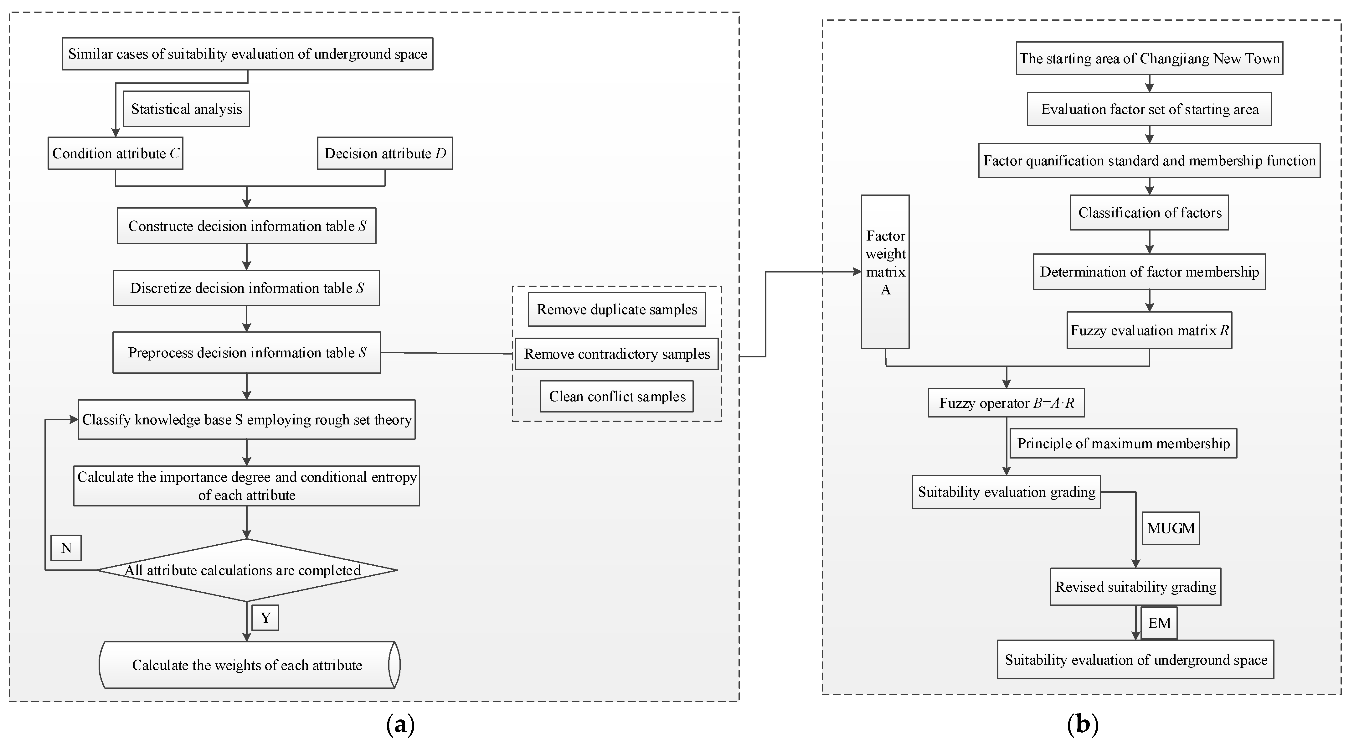
In this paper, based on the status quo of underground space development and utilization in the starting area of Wuhan Changjiang New Town and relevant data, a suitability evaluation model is developed. Rough set theory is used to construct a decision information table, preprocess sample data and classify the knowledge base. The concept of conditional entropy is introduced to calculate the attributes’ own and relative importance. Finally, the attribute weight of each classification index is obtained through standardization. On this basis, the fuzzy comprehensive evaluation method, the most unfavorable grade discrimination method and the exclusive method are used to evaluate the model, and the partition map of regional underground space development suitability is obtained.
2. Description of the Study Area
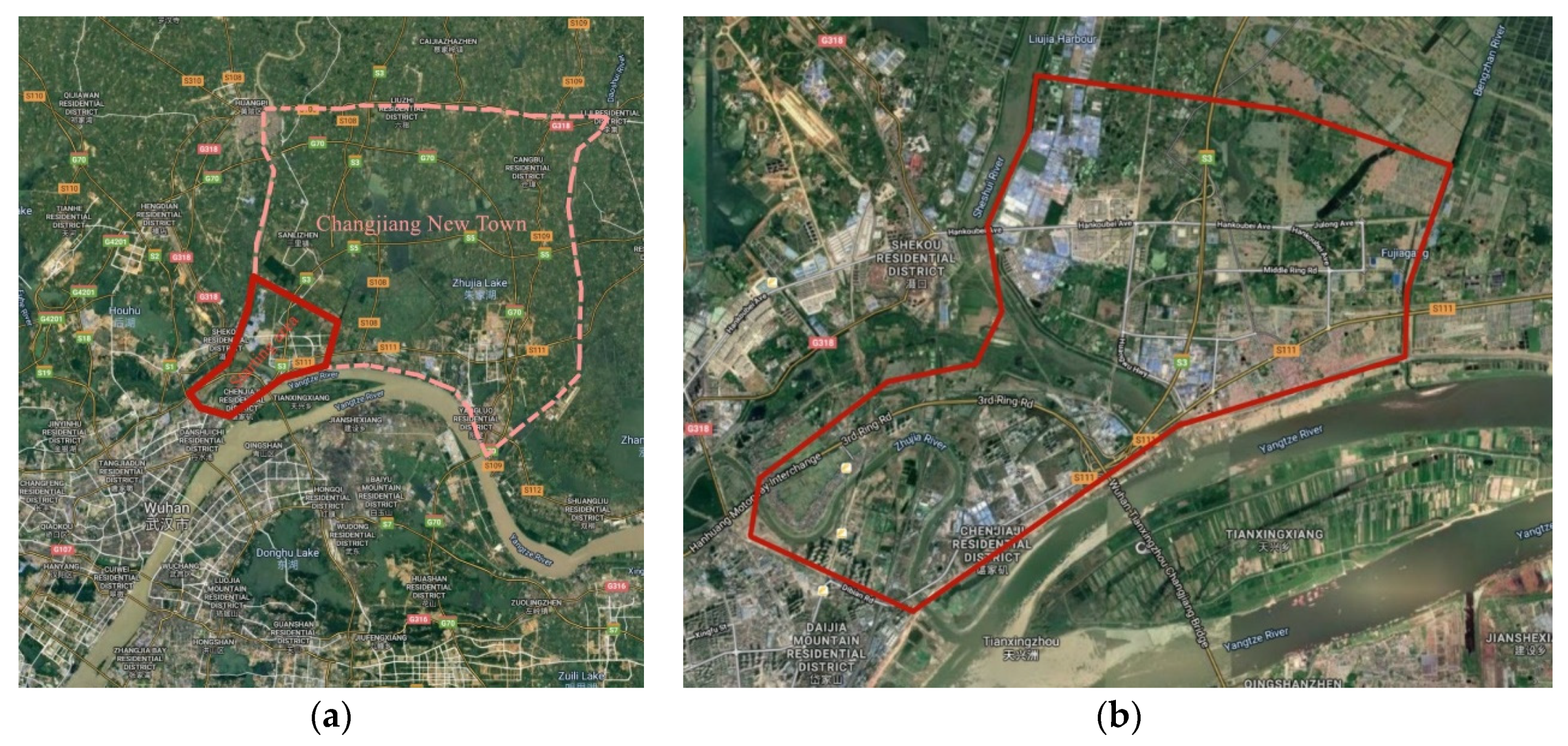
Wuhan is located in the middle of China, which is the transition zone from the southeast of Hubei and the eastern margin of Jianghan plain to the south of Dabie mountain. Wuhan is surrounded by the hills and ridges in the north and south portions, but in the middle portion the terrain is relatively low, which is the only mega-city in the six central provinces. With the rapid development of urban economy, urban population has further increased, and the accompanying traffic congestion, scarcity of land resources and other urban diseases have become further highlighted. It is an inevitable choice to fully develop and utilize underground space.
Changjiang New Town is situated in the northeast of Wuhan, with a planned construction area of about 560 km
2 (see
Figure 1a). The construction will be carried out in three phases, i.e., the starting area, the medium-term development area and the long-term construction area. The starting area of Changjiang New Town (see
Figure 1b) is mainly located in the Chenjiaji-Wuhu area, and it is about 70 km
2.
Due to its adjacence to the Yangtze River, Fuhe River, Sheshui River, Daoshui River and many other rivers and lakes, the water resources in the starting area are rich. The area is dominated by a plain landform, and the residual hills are separated from each other. The NW fault in the area is characterized by the Xiangguang fault, while the NE fault is marked by the Yangtze River fault. The limestone and dolomite in the area are developed with karst; thus, there is the possibility of a karst collapse geological disaster.
3. Study Methods and Evaluation Process
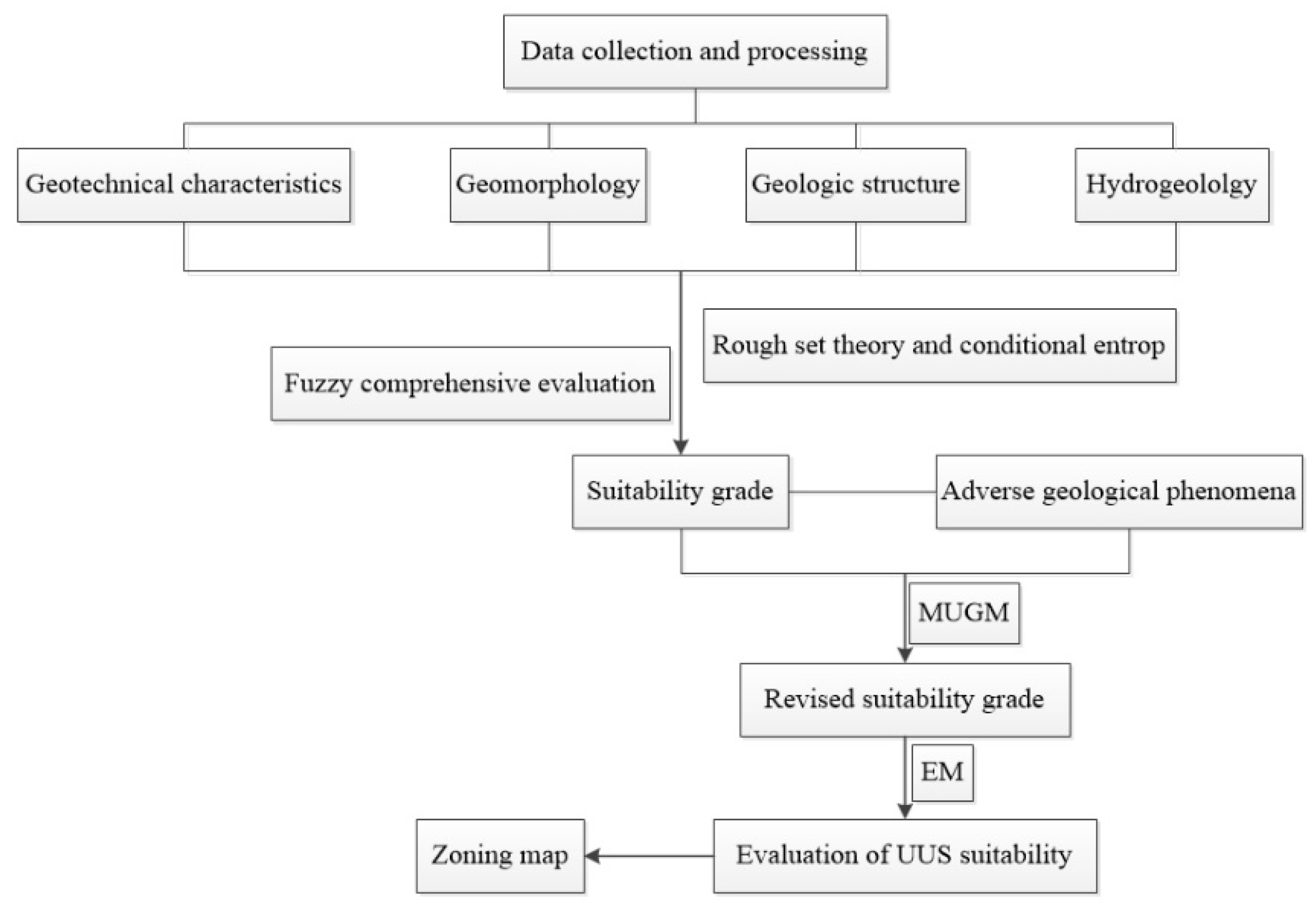
According to the data collected on the suitability of underground space development and utilization in five regions, combined with the engineering geological conditions of Wuhan [
23,
24], statistical analysis was carried out. This paper evaluates the suitability of underground space engineering geology in the starting area of Wuhan Changjiang New Town from six aspects: geotechnical characteristics, geomorphology, geological structure, hydrogeology, adverse geological phenomena and restricted development zone. The evaluation path is shown in
Figure 2.
3.1. Selection and Quantification of Indicators
There are many factors that affect the suitability of UUS. Firstly, the underground space takes the rock and soil mass as a carrier. The bearing capacity of rock and soil mass and the compressibility of soil mass determine the strength and stability of the layer of soil mass, which are related to the construction difficulty of underground space and the sensitivity to the influence of surface disturbance and deformation. Secondly, the study area is rich in water resources, which not only increases the difficulty of construction but also the long-term leakage problem that underground engineering still faces after construction completion. In addition, soft soil with different thickness and middle developed karst are distributed in the area, which will cause great harm to underground space development and ground construction. Finally, in ecological control areas, historical relics and monuments and underground water conservation areas, underground construction should meet the policy requirements and control the scale of development. According to the specific situation of the study area, the factors with strong correlation are selected, and the qualitative and quantitative indicators are evaluated by using the numerical method to divide them into five grades of excellent, good, medium, poor and very poor. The indicators are quantified by the following methods:
According to the membership function adopted in this paper, its quantitative score is selected from the interval of (0,100) by linear interpolation method;
For measurable indicators, the indicators are divided into five levels and quantified by referring to relevant literature and similar cases;
For the qualitative evaluation indexes that cannot be measured, expert evaluation is adopted to determine the membership degree of each grade.
Through the above methods, the quantitative and grading results of indicators are shown in
Table 1, and the membership degree of qualitative indicators is shown in
Table 2.
3.2. Determination of Index Weight
Different indexes have different influences on the evaluation results, that is, they are endowed with different weights in the calculation process. Accurate determination of the importance of each factor is an important premise for the evaluation results to conform to the reality. In previous studies, the analytic hierarchy process (AHP) and expert scoring method were mostly adopted. This method based on the decision makers’ subjective information to determine the weight of each factor relies too much on the level and ability of the decision makers, and the weight is not necessarily reasonable. So, the evaluation results may appear to have large differences. In this paper, the method of combining rough set and conditional entropy is adopted, which can fully reflect the objectivity of the data without providing any prior information outside the sample data set. Thus, the weight determination is more reasonable, and the evaluation results are more in line with the reality.
3.2.1. Rough Set Theory
Rough set (
Rs) theory is a theoretical method proposed by Pawlak et al. [
25] to study the expression, learning and generalization of incomplete and uncertain knowledge and data. It can mine potential and useful knowledge from a large amount of data and reduce the unnecessary workload of calculation and classification caused by redundant knowledge. In Rs theory, membership is no longer an initial concept but an objectively calculated one, which is only related to known knowledge, thus avoiding the influence of subjective factors [
26,
27,
28].
In rough set theory, an information table is a basic tool to express and process knowledge [
29]. The basic component of the information table knowledge expression system is the collection of research objects. The knowledge about these objects is described by specifying the attributes (characteristics) of objects and their attribute values. Generally, an information table knowledge expression system S can be expressed as:
where
is the set of objects, also known as the domain,
,
C is the set of conditional attributes and
D is the set of decision attributes.
is the set of attribute values,
is the range of values of the attribute
r and
.
is an information function, which specifies the properties of each object
X in
U. The decision table is a knowledge expression system with conditional attributes and decision attributes.
Knowledge in the knowledge base is not equally important, and some knowledge can be derived from other knowledge [
30]. For knowledge base
,
P and
Q belong to
R. If indiscernible relation
belongs to
, then knowledge
Q depends on knowledge
P. The dependence of knowledge
Q on
P is defined as:
where
card represents the cardinality of the set and
represents the positive region of the set
P in
and
where
Yn and
Et represent the basic sets of
and
, respectively.
In the decision table, when a certain attribute
in the attribute set
C is removed, the classification of the decision table changes greatly, indicating that the removed attribute is of high importance and vice versa. The concept of attribute importance is defined by the difference of attribute dependence:
The above equation shows how the positive domain of classification is affected when the attribute subset is removed from set C. When , the larger is, the more important is in the entire conditional attribute set. If , is a redundant attribute and can be reduced.
The importance of each attribute is normalized to obtain the weight
Wi of each attribute.
3.2.2. Method for Determining Attribute Weight Based on Rough Set and Conditional Entropy
In the process of using rough set theory to calculate the attribute weight, sometimes the attribute importance degree is zero, that is, the attribute weight is zero. The reason for this phenomenon is that the rough set theory only considers the importance of a single attribute to the entire attribute set, without considering the importance of the attribute itself, and ignores the practical significance of the attribute. To solve this problem, Bao and Liu [
31] introduced the concept of conditional entropy to improve the method. The calculation process is shown in
Figure 3.
In the decision information table
, the conditional entropy of the decision attribute set
relative to the conditional attribute set
is expressed as:
In the decision information table,
, and the importance degree of conditional attribute (index)
is expressed as:
where
indicates the importance of the conditional attribute
in the entire conditional attribute set, and
indicates the importance of the conditional attribute
Ci itself in the system.
Considering these two aspects comprehensively and carrying out standardization processing, the weight of each conditional attribute can be obtained:
However, when the value of conditional attribute
is less than three, the weight is always 1/2 according to the above method, which is too average. In this paper, it will be corrected and the importance degree of conditional attribute (index)
is expressed as:
where the conditional entropy and the normalized weight of
are still calculated according to Equations (6) and (8), respectively.
3.2.3. Examples of Index Weight Calculation
Fourteen partitions are selected as a sample set from the evaluation results of five regions. In terms of the criteria layer factors in this paper, the decision table is constructed where the geotechnical characteristics (
B1), geomorphology (
B2), geological structure (
B3) and hydrogeology (
B4) are considered as the conditional attributes, and the actual classification of underground space suitability is considered as the decision attribute (
D).
Table 3 shows the discretization results of the sample data.
The calculation process of index weight is as follows:
According to the process shown in
Figure 3a, the sample data are processed from three aspects.
- (1)
Removing duplicate samples: the fifth group and the tenth group are duplicate samples, thus the tenth group is removed;
- (2)
Removing contradictory samples: the level of each conditional attribute of the third group is two, one, two and two, respectively, which are all higher than the level three of decision attribute. It is not consistent with the reality, so let us dispose of the third group. Similarly, the seventh group is removed;
- (3)
Cleaning conflict samples: the sixth group and the first group have the same level of conditional attributes, but different levels of decision attributes are contradictory, so the sixth group is removed.
Through data pre-processing, sample data x1, x2, x4, x5, x8, x9, x11, x12, x13 and x14 are retained to form the decision table.
- 2.
Calculation according to rough set theory and conditional entropy,
Similarly, and can be calculated.
According to Equation (7), the importance of condition attribute
B1 is calculated as follows:
In the same way, the conditional entropy and importance of geomorphology (
B2), geological structure (
B3) and hydrogeology (
B4) are calculated, and the weight of each attribute is calculated according to Equation (8). The calculation results are shown in
Table 4.
- 3.
When the number of conditional attributes is less than three, fault (
C6) and seismic basic intensity (
C7) are taken as conditional attributes and geological structure (
B3) as the decision attribute according to index layer factors. After the above data pre-processing, the decision table is constructed (see in
Table 5).
According to the above calculation process, the conditional entropies of
C6 and
C7 are 0.12 and 0.18, respectively, and the importance degree is obtained according to Equation (9).
According to Equation (8), and are 0.535 and 0.465, respectively.
Based on the above decision table construction, sample data processing and the calculation process of attribute weight, the conditional entropy, importance degree and attribute weight of other factors in the index layer are calculated, respectively. The calculation results are shown in
Table 6.
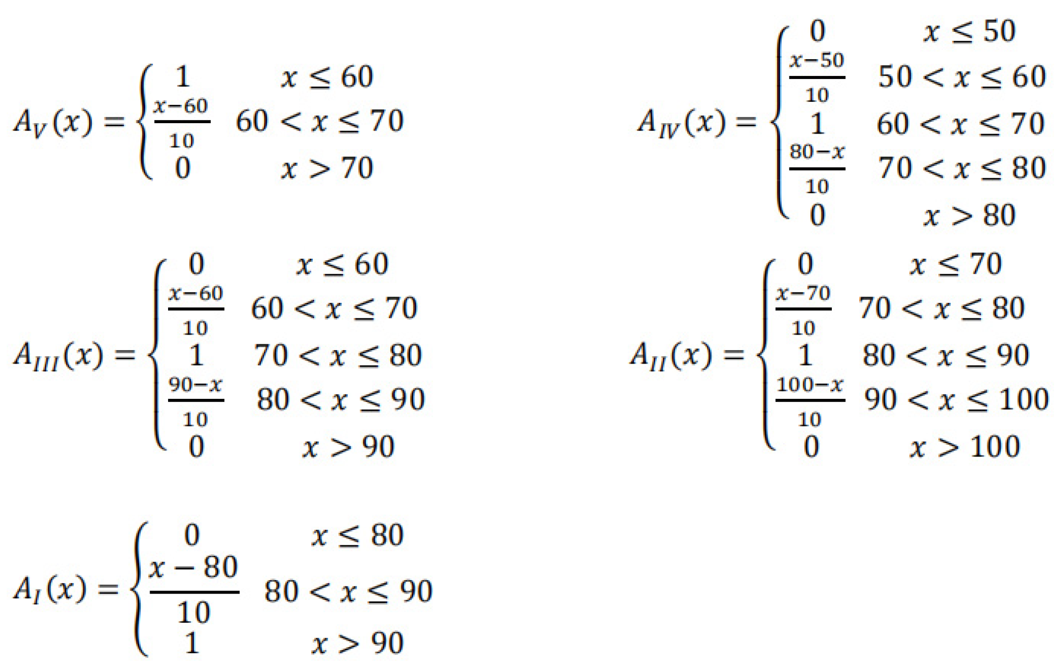
3.3. Fuzzy Comprehensive Evaluation
According to fuzzy comprehensive theory, the membership degree of each measurable single factor to each grade is determined by membership function. For ease of calculation, the membership function shown in
Figure 4 is adopted for all factors. At the same time, in order to give consideration to the evaluation of the overall factors, the weighted average type of synthesis operator is used to perform the fuzzy calculation. Finally, the grade is determined by the principle of maximum membership degree. The evaluation calculation process is shown in
Figure 3b.
3.4. The Most Unfavorable Grade Discrimination Method
According to the evaluation level of index factors, the lowest level is selected as the evaluation result. In the evaluation of adverse geological phenomena, if the superposition calculation is adopted for karst ground collapse and soft soil settlement, the scores of areas with adverse geological phenomena will be too average, which is different from the actual impact results. Therefore, the indexes of adverse geological phenomena are degraded by using the most unfavorable grade discrimination method.
4. Case Study
The Yangtze River is the highest river in the Changjiang New Town section. During the flood season, the water level of the Yangtze River is often higher than that of Wuhu Lake. When the Binjiang area in the Changjiang New Town is developed, attention should be paid to the protection of shoreline tidal wetlands. The ecological buffer zone should be set up within a certain range of river edge to avoid digging river sand, building artificial islands and large underground buildings, etc., because these will strongly change the hydraulic conditions and have a negative effect on the internal security of Changjiang New Town. Therefore, a restricted development zone should be set up within a certain range along the river.
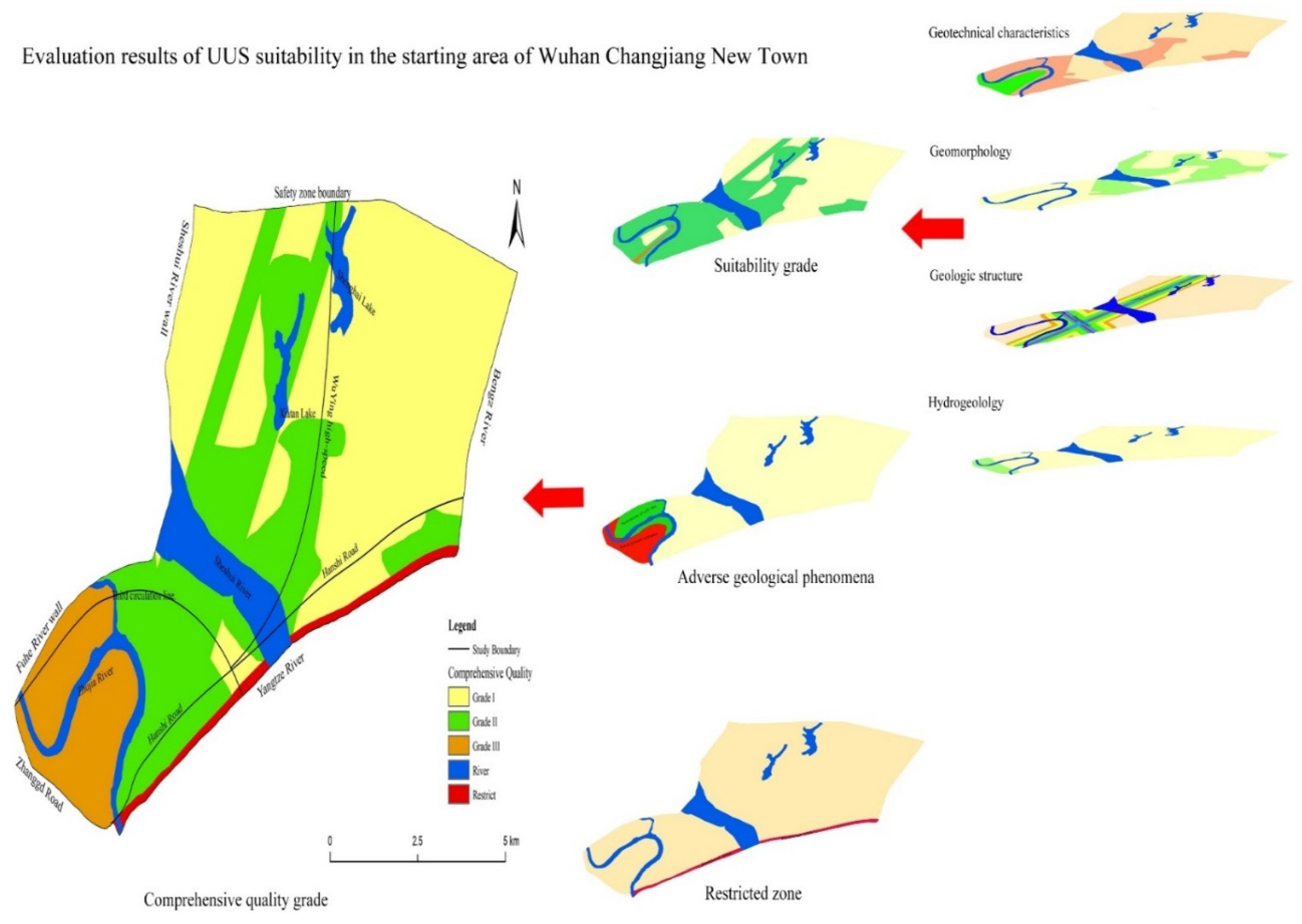
On the basis of collecting various data, this paper imports the screened and pre-processed data into the geographic database. According to the established index system and evaluation methods, the properties of each zoning unit are evaluated, classified, superimposed and calculated, and finally the evaluation results of the suitability zoning of underground space in the starting area of Wuhan Changjiang New Town are generated, as shown in
Figure 5. The summary table of the evaluation results is shown in
Table 7.
Combined with the suitability zoning map and the evaluation summary table, it can be known that:
- (1)
On the whole, the suitability of underground space development and utilization in the starting area of Wuhan Changjiang New Town is good. The evaluation results mainly include excellent suitability (class I) and good suitability (class II), and the proportion of medium suitability (class III) is small. According to the evaluation criteria and methods in this paper, there are no areas with poor suitability or very poor suitability in the starting area of Changjiang New Town.
- (2)
In the starting area, most of the areas north of the Sheshui River have better geotechnical conditions and geomorphological conditions, but the water content in this area is abundant, and single well yield can be up to 467.467–666.399 m3/d. Therefore, during the development and utilization of this area, the main restriction condition is groundwater.
- (3)
The areas with relatively poor suitability are mainly concentrated in the southwest side of the starting area. The hydrogeological conditions in this area are complex, and there is the phenomenon of soft soil surface subsidence and karst ground collapse medium development. The development and utilization of underground space is relatively unfavorable.


