Abstract
Because of its large area and complicated space utilization, in the event of a disaster, rescue efforts in specific areas of Taipei Main Station would be difficult. In addition, rescue efforts are also difficult to implement, because each area is managed by different units. In order to ensure emergency and safe evacuation of passengers and reduce the loss of related property during a disaster, a suitable disaster prevention system is required. This study conducted risk assessment based on the triggering factors of disaster types over the years. After synthesizing the results of the disaster risk assessment, a disaster preparedness contingency plan was designed. According to the Incident Command System (ICS), this study formulated the usual management measures and emergency response procedures for various levels of disasters. When an accident occurs, the system can automatically initiate various emergency disaster relief measures, monitor the development of the incident, transmit disaster information, and coordinate disaster emergency response procedures. This study established a building information modeling (BIM)-based cyber-physical system (CPS) and intelligent disaster prevention system integrated under the overall management of the Intelligent Joint Emergency Operation Center. The “Taipei Main Station Intelligent Disaster Prevention System” can manage the disaster prevention and relief information of various business entities in a unified way, and provide an intelligent disaster prevention function integrating BIM and virtual reality (VR). This system is functionally verified through exercises such as short-circuiting of wires in advertising boxes, firefighter disaster relief drills, indiscriminate violent attacks, and demolition of explosives. In this study, ICS was established through expert interviews, disaster-causing factors over the years, and a cloud-based electronic management system was established in combination with the BIM platform. The system provides emergency and safe evacuation of passengers in the event of a disaster, and reduces the loss of related properties.
1. Introduction
1.1. Background
Specific areas of Taipei Main Station are 46.31 hectares. Because of the wide area, complex spatial structure, large flow of people, numerous unidentified people entering and exiting, and wide range of uses, rescue in the event of a disaster is both difficult and dangerous. Each spatial block of the Taipei Main Station is operated by different units; rescue commands are thus difficult to unify in the event of disaster. In October 2019, the Taipei City Government established the Intelligent Joint Emergency Operation Center of Taipei Main Station to coordinate the overall management of specific areas of Taipei Main Station.
Management procedures included activation of various emergencies, integration of monitoring of incident conditions in specific areas of Taipei Main Station, dissemination of disaster information, and coordination of daily management and emergency response measures during disasters. According to different disaster types and risk analyses, the Center formulated emergency response guidelines for different disaster levels, integrated the disaster prevention and relief information of various units, and provided an intelligent disaster prevention system that integrates BIM and CPS to ensure the safe emergency evacuation of passengers during disasters.
1.2. Research Motivation
Over the past decade, CPSs have emerged as an attractive research topic [1,2,3,4]. Considerable advancements have been made in the research of its theoretical basis and application extension [5,6]. The National Science Foundation has listed CPS as a key research and funding project; and governments in Europe, South Korea, and Japan have also provided CPS-related research funding. At present, the government of Taiwan focuses on integrating CPS (e.g., network, manufacturing, and factories) in Industry 4.0. However, Industry 4.0 neglects the application of cloud computing and big data in architecture engineering construction [7] in conventional industries. Therefore, this study used relevant information technologies (such as software design, development and installation) and communications technologies (such as transmission access, network switching and private network communication) to develop a BIM-based CPS intelligent disaster prevention system, which integrated and promoted the disaster prevention management of related facilities such as the Artificial Intelligence of Things and fifth-generation cellular networks from the user end. The system developed in this study will provide relevant monitoring data on site in specific areas and disaster prevention and relief related information to the Intelligent Joint Emergency Operation Center in the form of two-dimensional/3D graphic display, shortening the response time of the Center and improving the efficiency of disaster relief in specific areas.
1.3. Research Objectives
This study summarized relevant information to construct a BIM-based CPS intelligent disaster prevention system for Taipei Main Station. The system integrated the disaster prevention and relief information of each user unit, provided a three-dimensional (3D) visual management platform, and improved maintenance efficiency, operational management, and disaster emergency response in specific areas of Taipei Main Station. The specific research objectives were as follows:
- A.
- To create a BIM floorplan for specific areas of Taipei Main Station;
- B.
- To analyze risk factors in the specific areas and formulate an emergency response plan according to emergency response standard operating procedures;
- C.
- To establish a management platform for the intelligent disaster prevention system of Taipei Main Station through use of a BIM-based CPS.
2. Literature Review
This paper divides the past research into three parts to sort out the relevant content of these literatures, namely: BIM-based CPS, Emergency Response Plan of the Incident Command System, and BIM-based Intelligent Disaster Prevention System.
2.1. BIM-Based CPS
CPS has emerged over the past decade and has become one of the most advanced research areas. CPS is a highly integrated system communication, computation and control strategy. Although CPS has been studied and applied in the fields of intelligent transportation, intelligent manufacturing, intelligent building, and smart cities [8], the research on the intelligent disaster prevention and mitigation structural system based on CPS is still lacking. Cyber-physical systems have emerged over the past decade and are an attractive research topic today [2,3]. As an important emerging research field, related academic seminars have been held in many developed countries in the world. In 2007, CPS was listed as one of the eight key information technologies in the US President’s Science and Technology Advisory Committee [8]. The Natural Science Foundation of the United States has continuously listed CPS as a key research area and a funded project topic. CPS-related studies have been conducted not only in the United States, but also in Europe, South Korea, and Japan. Lee [9] defines CPS as: “Integrations of computation and physical processes. Embedded computers and networks monitor and control the physical processes, usually with feedback loops where physical processes affect computations and vice versa”. Applying this concept combined with BIM technology to building disaster prevention is also the current research and development trend of smart buildings. CPS-based technology has been studied in many fields, and great achievements have been made in both theoretical basis and application expansion [5]. Lei et al. [8] used a BIM platform and the Internet of Things (IoT) to construct a CPS cloud architecture that can monitor, identify, control, and coordinate in depth in real time. In addition, Xing et al. [10] applied CPS data to identify, review, and exchange online and reusable components, which can improve life cycle management. Chen et al. [11] used information and communications technology to detect cross-domain cyberattacks and vulnerabilities in urban railway systems and presented valuable security analysis results. Moreover, Basile et al. [12] noted that in railway CPS, digital sensors and physical facilities can be used to adjust the surrounding environment to achieve energy saving. Monedero et al. [13] proposed a CPS that can collect and identify biological sound systems with IoT sensors. Deka et al. [14] introduced a transportation CPS and noted that the use of sensors, embedded computers, and network monitoring equipment can affect cyberspace in terms of reliability, availability, security, privacy, and performance indicators (e.g., bandwidth, network speed, and transmission data size), which assists the infrastructure with real-time data collection and data analysis. All of these conditions are necessary for real-time management.
Kepes et al. [15] applied a CPS in situation-aware updates. When users download the application while on the train, the system can automatically update advertising items. Cancila et al. [16] proposed a python deep learning CPS to explore students’ learning outcomes in relation to subject-specific teaching methods and suggested modifications to the teaching methods. Furthermore, Bonci et al. [17] applied a BIM-based CPS to automatically monitor various facilities of a building, calculate the performance of key indicators, and evaluate the efficiency of each subsystem and the overall efficiency of the building. The system can store facility operation records, assisting facility managers in relevant decision-making analysis. Kim et al. [2] stated that CPS control can integrate the underlying communication system of a distributed network, which has crucial implications for engineering design, transportation, energy, and medical systems. This study utilizes the characteristics of cyber-physical systems that can integrate information such as perception, computing, communication, and control, and applies these technologies in the smart disaster prevention system of this research.
2.2. Emergency Reesponse Plan of the Incident Command System
The ICS is a special method for composing and controlling the employment of many highly reliable temporary organizations and public safety professionals to manage various resources in an emergency. ICS is mandated by all responding organizations in the United States to respond to routine and large-scale hazard events [18,19]. The actual use details and usefulness of the system are not known. Ideally, research on these issues should be carried out within the norms of national information systems and their follow-up missions. Disaster related scholars have noted, however, that for some reason, since the 1970s, there has been little empirical support for the use of ICS to varying degrees by various organizations to classify international disasters. The organization and employment of all disaster response events across the country by ICS, regardless of their complexity, duration or size, is even less known [20,21]. Gregory et al. conducted an inductive study of ICS use by fire departments and identified three main factors: structuring mechanisms, constrained improvisation and cognition management methods. [18] This unique bureaucratic system enables a very flexible and reliable organization for complex and changing task environments. New ICS organizations can take advantage of bureaucracy’s control and efficiency advantages while avoiding or overcoming its bureaucratic habits. Bjelland et al. [22] noted that continual improvement in the design, planning, and operation stages is necessary to achieve the effective management and control of tunnel fires. Furthermore, emergency response plans must be adjusted according to risk assessment results, with their scope extending to detection, alarm, mobilization, disaster rescue, evacuation, and maintenance and management at normal times. Wang et al. [23] and Feng et al. [24] have stated that an effective ICS must thoroughly integrate organizations and emergency plans at all levels, and mobilize necessary emergency services and personnel. Moreover, Feng et al. [24], Gai et al. [25,26], Jiang et al. [27], and Zio [28] have recommended that safety management personnel develop emergency response plans and conduct risk assessments before an accident occurs. Chan et al. [29] provided incident command, resource management, and informatics support through internet-based intelligent devices in the chaotic environment of mass casualty incidents. In addition, Falakh et al. [30] used the matrix method to evaluate the probability, frequency, and severity of each factor hazard in hazard identification and risk assessment in a water treatment plant, with 22 potential hazard factors identified. Janzer [31] noted that in the past, most relevant government departments claimed that participating in emergency management training and education was unnecessary. Later, ICS training was verified in several cases to be an effective incident management method. The ICS requires personnel to command and coordinate with other units and act rapidly and correctly during an incident to ensure efficient management. Marion County Government [32] used operational orientation to integrate communications and warnings and clearly defined the responsibilities of counties, cities, volunteers, and other organizations through the planning of an incident management system and emergency support functions to facilitate rapid deployment, disaster relief resource distribution, evacuation and shelter operations, and post-disaster response and recovery activities. Based on the above discussion, this research summarizes the risk assessment of disaster factors over the years, integrates the relevant units of Taipei Main Station and their notification channels with their superiors, as well as the emergency disaster response management and control command for system development, so as to meet the disaster prevention needs of each relevant unit.
2.3. BIM-Based Intelligent Disaster Prevention System
Building Information Modeling was introduced in the 1970s. It simulates the real condition of the building based on all relevant information about the project. Now it has developed to BIM5.0: Smart City Cloud [8]. BIM5.0 is the construction of a smart city management platform based on BIM and GIS. It combines urban geographic information with 3D building information model to realize scientific, informational and visual operation management of smart cities. There are many kinds of natural disasters, and domestic and foreign scholars have made great progress in disaster prevention research. Relevant achievements include systems integrating geo-informatics, and cloud services to deal with snowmelt flood disasters [33], mathematical programming models for marine environmental pollution caused by marine liquid chemical spills, and regional climate change and its ecological effects [34]. The framework for the development of these disaster response management systems proposes a new type of information system based on the integration of multidisciplinary tools. Cheng et al. [35] reported that BIM, which has been widely used in the assessment and planning of fire safety, can be combined with wireless sensors and real-time dynamic fire information to effectively control and facilitate fire rescue. Cheung et al. [36] stated that a wireless sensor network is one of the key technologies in the development of the IoT, enabling components and sensors to be combined with equipment and BIM to provide a visual method integrating databases and geometry into digital models. Hosseini et al. [37] indicated that the use of a simulation engine integrating four dimensional-BIM modeling and social force modeling for the fire emergency evacuation of construction sites can provide immediate safety decision support through analyzing evacuation risks using models. Additionally, Bourhim et al. [38] applied the analytic hierarchy process to VR game simulation, which has aided evacuation research. Darko et al. [39] noted that VR and augmented reality can assist users in understanding modular integration. However, because of their inability to promote interoperability and collaboration among participants, open BIM and Industry Foundation Classes formats were used to solve the problem, and multiuser online use was performed through the BIM server application. Kasereka et al. [40] argued that in the case of fire, evacuees must make a quick decision to avoid obstacles and choose the nearest exit door. Thus, in this study, agent-based modeling and evacuation simulation were employed. Rüppel and Schatz [41] used a fire protection design for BIM and a game engine (e.g., fire and smoke) to simulate the predicted spread of fire and smoke and potential routes for safe evacuation and analyzed the overall safety performance of the building. [42] Omar et al. [8] have proposed a (3D) prototype visualization to provide accurate location of interior spaces and facilities help disaster relief. Suhyun et al. [8] have proposed a (3D) prototype visualization to provide accurate location of interior spaces and facilities help disaster relief. This paper uses the above technologies combined with BIM in disaster response emergency evacuation tasks. The “Taipei Main Station Intelligent Disaster Prevention System” developed in this research uses graphical communication to display disaster locations, escape routes, disaster relief routes, and resettlement areas for people with disabilities.
3. Materials and Methods
The intelligent disaster prevention system developed in this research includes the Taiwan Railway, High Speed Rail, Taipei MRT, Taoyuan Airport MRT, Taipei Underground Street, Eslite Underground Street, Zhanqian Underground Street, Zhongshan Underground Street and Breeze Square, as shown in Figure 1.
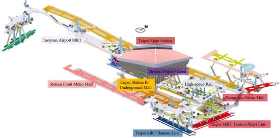
Figure 1.
Areas of Taipei main station. (Source: Taipei Main Station Intelligent Joint Disaster Prevention Center, 2020).
The planning of this system integrates the disaster situation that occurs on site in a specific area according to the emergency response mechanism activated by the disaster level. The content includes collecting and reporting disaster information, coordinating disaster reduction management in peacetime, and emergency response measures in the event of a disaster. Based on the analysis of different disaster categories, levels and risks, this study formulates emergency response guidance procedures for disasters of various categories and levels. This can ensure that a large number of passengers in a specific area can be evacuated smoothly to ensure the safety of passengers when a disaster occurs. The research team visited two major stations, Osaka and Kyoto, Japan at the beginning of the system planning period as design examples. The interviewees included Taipei Disaster Response Center, front-line units of fire protection, various business entities around the station, rolling work camp meetings, expert consultation, etc. These are important prerequisites for designing emergency response plans and systems. The research flow chart of this system is shown in Figure 2.
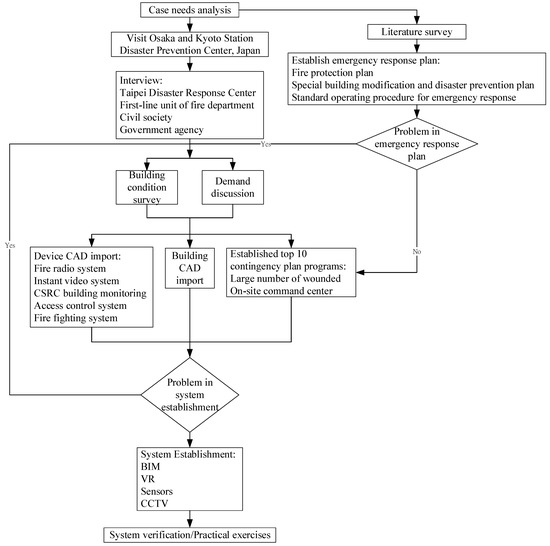
Figure 2.
System research flow chart (Source: Research Data).
3.1. Integrate Related Specification and Documentation
For the development of this smart disaster protection system, this study collected and compiled all relevant public and private internal documents. Based on these documents and plans, the “Taipei Main Station Intelligent Disaster Prevention System” can be deliberated. These documents include:
- A.
- “Ministry of Transportation Disaster Emergency Notification Operation Points” [43].
- B.
- “Standard Operating Procedure for Emergency Response of the Joint Emergency Operation Center of Specific Areas in Taipei Main Station” [44].
- C.
- “Liability for Guarantee of Fire Protection Plan of Site Utilization Cooperative in Station Front Metro Mall” [45].
- D.
- “Common Fire Protection Plan for Specific Areas of Taipei Main Station” [46].
- E.
- “2018 Annual Fire Protection Plan” [47].
- F.
- “Report on Special Building Modification and Disaster Prevention Plan of Taipei Main Station Building systems” [48].
- G.
- “Fire Protection Plan for Taipei Station, Taiwan High Speed Rail” [49].
- H.
- “2018 Breeze Fire Protection Plan” [50].
- I.
- “2018 Fire Protection Plan of Zhongshan Metro Mall of Taipei Rapid Transit Corporation” [51].
- J.
- “2017 Fire Protection Plan of Station Front Metro Mall” [52].
- K.
- “2019 Taiwan Railway Emergency Response Plan” [53].
3.2. Create 3D-BIM Drawing Data for Taipei Main Station
Taipei Main Station was originally established in 1891. The current station was completed in 1989 and began to provide services. Since the beginning of use, it has experienced expansion and decoration. In addition, it was difficult to preserve the project data in the early years. Some of the interior decorations were not demolished and on-site investigation was carried out to make up for the lack of information. Taipei Main Station is a building with seven floors above ground and three floors underground. The on-site investigation work includes photography, video recording and actual measurement to obtain more accurate information on the current situation. The database uses the COBie format to create table properties. In this study, Archibus software was used to transfer the required spatial data, as shown in Table 1. The names of the added fields and their meanings are shown in Table 1.

Table 1.
Spatial column data used in this study.
3.3. Develop Emergency Response Plan for Taipei Main Station
This study integrates various business entities to develop emergency response plans. The main principle is not to break the original disaster prevention and relief organization of each business entity. This study introduces the framework of Incident ICS to establish a joint disaster prevention and relief system. The interview targets include nine units, such as Taiwan Railway, High Speed Railway, Taipei MRT, Airport MRT, four Underground Streets and Breeze Plaza. According to the organization of the Joint Disaster Prevention Center, through the platform conference and consensus camp meeting, the SOP of emergency response plan is established after consensus is reached.
3.3.1. Hazard Factor Analysis
The specific area of Taipei Railway Station includes: four railways, four underground streets and Breeze Plaza, a total of nine areas. The types of disasters over the years include fire, earthquake, computer room accident, suspicious gas, accidental terrorist attack, typhoon, flood, traffic accident, weapon (explosive) attack, damage to system equipment, and abnormal power outages. According to the theory of disaster risk assessment, it is often expressed as the product of “occurrence probability” (P) and “influence degree” (S).
This study has distributed a Risk Assessment Form for Ten Hazards to be filled out by fire managers and self-defense firefighters in the area. After taking back the risk assessment sheet, the disaster risk assessment sheet for various disasters is sorted out. Finally, a comprehensive disaster risk assessment table for ten disasters is integrated. Resource management during the disaster events is regrouped in the comprehensive disaster risk assessment table. Table 2 is the explanation of the probability of fire disaster. Table 3 is the fire hazard severity statement table. Table 4 is the disaster resilience assessment instruction table. The above three forms are issued to the person filling out the fire risk assessment table (Table 5) as a reference. There are ten possible types of disasters investigated in this study. Table 6 is the final comprehensive disaster risk assessment table compiled in this study. The function of this table is used as reference in the development of “Taipei Main Station Intelligent Disaster Prevention System”. This allows the software to reduce or eliminate activities that are likely to occur during normal times; once an immediate hazard impact is identified, relevant preventive measures can be taken quickly.
Table 2.
Explanation table of the probability of fire disaster.
Table 3.
Fire hazard severity statement table.
Table 4.
Disaster resilience assessment instruction table.
Table 5.
Fire hazard risk assessment table.
Table 6.
Disaster risk assessment table.
3.3.2. Types of Disasters and Definitions of Disaster Levels
This study refers to the key points of disaster emergency notification operation regulations of the Ministry of Communications [34], and analyzes the disaster level when various types of accidents occur in a specific area of Taipei Main Station. In this paper, the scope of various disasters and the related fields near the disaster site are classified according to the scale of the disaster, the state of casualties and the importance of news. The disaster is divided into three levels: the third-level disaster (minor disaster) is the yellow-light warning; the second-level disaster (medium disaster) is the orange-light warning; and the first-level disaster (big disaster) is the red-light warning (as shown in Table 7). The system will automatically export disaster relief Standard operating procedures (SOP) according to various disaster levels.
Table 7.
Types of Disasters and Disaster Level Definitions in the Specific Areas of Taipei Main Station.
3.4. Develop “Taipei Main Station Intelligent Disaster Prevention System”
The system platform proposed in this study was integrated and developed on the basis of a central supervisory and remote control (CSRC) system, including dual-screen management, a data center, the Joint Emergency Operation Center, and a general disaster prevention center. The operating system was linked to the data center, as illustrated in Figure 3. In Figure 3, the system data interface includes Fire alarm, CCTV, CSRC, Graphic and Control. The system uses a dual-screen design to display Google Map and BIM/Facility management. The system platform includes:
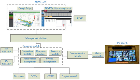
Figure 3.
System interface diagram. (Source: Taipei Main Station Intelligent Joint Disaster Prevention Center, 2022).
- A.
- Database system: Microsoft SQL Server was the database management system used in this study platform and was responsible for the connection of back-end data management and graphics integration;
- B.
- Graphics display system: Google Map and BIM (Revit) performed the front-end graphic display of related information, displaying coordinates and related action paths on the relevant webpage.
- C.
- Communication protocol architecture: The communication architecture integrated the underlying data of the system, connected the system in series and quickly switched for the data querying of pictures or texts (Figure 4).
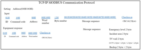 Figure 4. Communication protocol. (Source: Taipei Main Station Intelligent Joint Disaster Prevention Center, 2022).
The main content of developing this intelligent disaster prevention system was to integrate various fire protection tools, alert relevant personnel, and notify the fire department of relevant information when a fire occurs. Its functions are described as follows:
- A.
- MAP/BIM: Display disaster information and the regional map division management model, apply Google Maps as the construction platform, and use FORGE as the 3D graphic switching platform;
- B.
- Equipment information query: Provide disaster prevention and relief resources, equipment information, and equipment maintenance functions;
- C.
- Image file management: Upload and download files related to disaster prevention and relief resources;
- D.
- Disaster record management: Manage disaster prevention and responses to previous warnings;
- E.
- Emergency signal management: Provide four-level disaster signal display and notification, fire equipment status monitoring, and abnormal signal dispatch management;
- F.
- Dispatchment and maintenance management: Provide preventive maintenance, dispatch management, and inspection management required for the maintenance management system;
- G.
- Data analysis: Weakness analysis (excessive amount of abnormal equipment damage) and excessively high frequency reporting from the areas of disaster sites.
This intelligent disaster prevention system can be connected to a central data center through a web terminal, which grants access to the integrated management platform of disaster prevention and relief information to users. The system development environment was Apache Tomcat; the front-end was JSP and JavaScript; the back-end was Java; and the database used the Microsoft SQL Server.
4. Results
This intelligent disaster prevention system achieved self-sensing, automatic execution, and automated decision-making of fire information through an integrated management platform such as a series connection of a fire alarm, CSRC, and central monitoring system and disaster prevention and relief information, as depicted in Figure 5. To shorten the disaster relief time, the system adopted a one-click trigger method to shorten the response time of the Emergency Operation Center. The system can automatically provide an on-site equipment data map, suggest response actions, and integrate with the BIM disaster relief information of the Emergency Operation Center. This system can also replace conventional manual reporting with its transmission of disaster relief information, thereby reducing the possibility of disaster relief delay and providing disaster relief within the “golden time”.
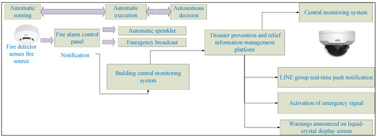
Figure 5.
System architecture of the automatic sensing and automated decision-making of equipment. (Source: Taipei Main Station Intelligent Joint Disaster Prevention Center, 2022).
4.1. Predisaster (Usual) Preparedness
This intelligent disaster prevention system promoted the performance of pre-disaster preparation work by relevant personnel at normal times. These pre-disaster preparations included self-inspecting disaster prevention procedures, establishing a list of fire protection organizations, formulating evacuation plans, training fire protection organizations, assisting in evacuation planning and drills, and strengthening the self-rescue and disaster prevention capabilities of various units and coordinated disaster relief. The content included the following:
- A.
- On-site situational training: Conduction of disaster prevention and relief education training using on-site 720-degree photos 1 as shown in Figure 6. The images in Figure 6 include:
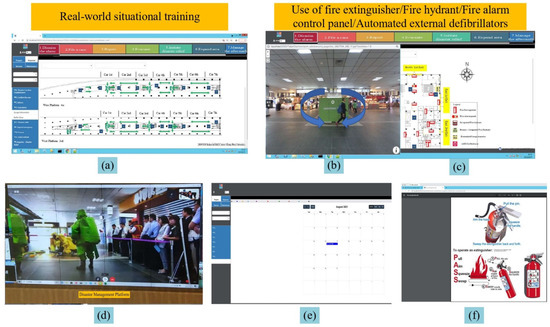 Figure 6. Pre-disaster (usual) preparedness: real-world situational training. (Source: Research Data). (a) Exit; (b) 360 degrees display screen; (c) Disaster relief equipment; (d) Drill simulation; (e) Drill time announcement; (f) Use of disaster relief equipment.
- (a)
- When the escape button in the left picture is touched, the system will show the escape route in the middle display screen.
- (b)
- This monitor can display 360-degree live photos through control. It can display the escape route map selected in Image (a).
- (c)
- This display shows the location of the relevant firefighting facilities. These firefighting facilities include fire extinguisher, fire hydrant, fire alarm control panel and automated external defibrillators. When a facility is selected, its usage method and steps will be shown in Image (f).
- (d)
- The drill simulation for National Disaster Prevention Day.
- (e)
- This display shows the monthly disaster prevention drill time notice for each organization.
- (f)
- This screen shows the operation method and steps for how to use the firefighting facilities selected from Image (b).
- B
- Regular inspection of equipment: Adoption of a flexible and free combination report method. Regular inspection of facilities can be followed by adjustment of inspected items according to equipment update schedules (Figure 7). The images in Figure 7 include:
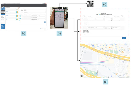 Figure 7. Pre-disaster (usual) preparedness: Equipment inspection. (Source: Research Data). (a) Inspection form; (b) APP; (c) QR Code; (d) Display equipment location.
- (a)
- Each unit can combine its own periodic checklist as needed.
- (b)
- Inspectors can use the app to perform on-site inspections.
- (c)
- Scan the QR Code to apply for repairs when the facility is found to be faulty during the inspection.
- (d)
- After the regular inspection records are archived, they can be automatically recorded to the back-end management platform. The system can display the inspection route and inspection time.
- C
- Reporting to the supervisory unit according to standard operating procedures. In Figure 8, the image on the left is all relevant higher-level organizations of the disaster prevention and control center; the picture on the upper right is the reporting matter; the picture on the lower right is the contact information of the higher-level unit. In this study, the disaster level is divided into three levels. In Table 8, the texts marked in yellow are the units that need to be notified when the Level-3 disaster occurs; the texts marked in orange are the units that need to be notified when the Level-2 disaster occurs; the texts marked in red are the units that need to be notified when the Level-1 disaster occurs.
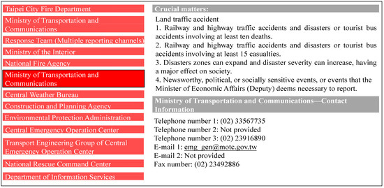 Figure 8. Television screen display of intelligent disaster prevention system in Taipei Main Station. (Source: Research Data).
Table 8. Report to the superior units at all levels according to SOP.
Figure 8. Television screen display of intelligent disaster prevention system in Taipei Main Station. (Source: Research Data).
Table 8. Report to the superior units at all levels according to SOP.
4.2. Disaster Management
This intelligent disaster prevention system can perform data collection, analysis, actuation, and display through the 3D BIM visual model during disasters. For example, a 3D model can be used to query the location of fire and disaster relief equipment in the building to ensure the consistency, continuity, and integrity of information transmission between various operating units in the building. Moreover, through centralized data management and functional modules in the operation platform, emergency management, inspection, and response within the organization can be coordinated among units, thereby achieving management effects such as response efficiency and resource utilization optimization. The content included the following:
- A
- Adoption of response-triggered standard operating procedures. The related operations include (a) dismiss the alarm, (b) file a case, (c) report, (d) evacuate, (e) initiate disaster relief, (f) expand area and (g) manage the aftermath (Figure 9). This standard handler avoids panic-stricken errors.
 Figure 9. Disaster management: Standard operating procedures for response trigger. (Source: Research Data).
 - B
- Use of graphics instead of text to explain relevant locations, telephone numbers, and disaster relief facilities. The images in Figure 10 include (a) the location of the exits, (b) the parking areas of the fire truck, (c) the location of fire hydrant, and (d) temporary injured placement.
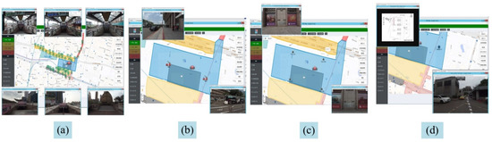 Figure 10. Disaster management: Graphical explanation of relevant geographical locations. (Source: Research Data). (a) Exit; (b) Fire truck parking areas; (c) Fire hydrant locations; (d) Casualty areas.
 - C
- Application of a one-click trigger to report relevant integrated information to the fire department and all co-construction units. The system used BIM to automatically display disaster relief information, including (a) fire locations, (b) smoke prevention, (c) fire protection, (d) control area, (e) buffer and (f) rescue waiting areas, as summarized in Figure 11.
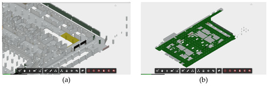
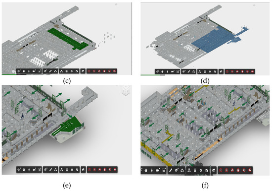 Figure 11. Disaster management: BIM automatic display of disaster relief information. (Source: Research Data). (a) Fire location; (b) Smoke prevention area; (c) Fire protection area; (d) Control area; (e) Buffer area; (f) Rescue waiting areas.
 - D
- The intelligent disaster prevention system developed in this research has the function of triggering all actions with one key, including: (a) One click action, (b) LINE report, (c) marquee information, (d) disaster location, (e) BIM escape, (f) Level-3 signal trigger, (g) CCTV, (h) nearest exit, and (i) nearest fire escape (Figure 12).
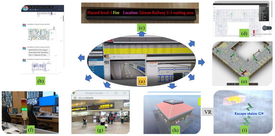 Figure 12. Disaster management: One-click integration to automatically trigger response and report to the fire department and co-construction units. (Source: Research Data). (a) One-click trigger; (b) LINE report; (c) Marquee information; (d) Disaster location; (e) BIM escape; (f) Level-3 signal trigger; (g) CCTV; (h) Nearest exit; (i) Nearest fire escape.
 - E
- Reporting follow-up information for expanded response measures: Integration of replies from designated units with current situation information, such as (a) review of the extended areas, (b) buffer areas, (c) examine extended areas and (d) disaster relief support inquiry (Figure 13). This process mainly comprised collecting, evaluating, processing, compiling, and reporting disaster situations.
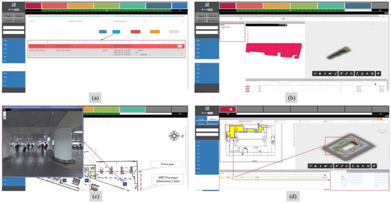 Figure 13. Disaster management: Expanded response procedures. (Source: Research Data). (a) Expanded response handling; (b) Examine extended areas; (c) Buffer area; (d) Disaster relief support inquiry.
4.3. Postdisaster Management
The post-disaster emergency assessment of this intelligent disaster prevention system constituted the requesting of relevant professional and technical personnel to make a preliminary emergency judgment on damage levels of affected buildings within a short period of time after a disaster occurs, and to establish a list of casualties and facilitate implementation of relevant disaster emergency response measures by the commander of the Emergency Operation Center. The content included the following (Figure 14):
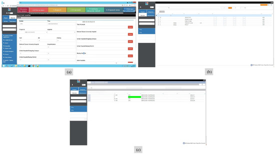
Figure 14.
Post management: Recovery of follow-up inquiry. (Source: Research Data). (a) Generate number of casualties; (b) Follow up with incident control center; (c) Recover follow-up inquiry.
- (a)
- Generation of casualty and medical information;
- (b)
- Archiving of relevant disaster record documents after the alarm is switched off;
- (c)
- Restoration of follow-up files for record processing.
5. Discussion
As mentioned in Section 2.3, Cheng [36] and Cheung et al. [35] have applied BIM and wireless sensor IoT in fire information management, but their studies lacked verification of the ICS disaster relief response. Bourhim et al. [38] and Kasereka et al. [40] have used VR to simulate evacuation, but they did not incorporate the IoT into the simulation models. In addition to the aforementioned research contributions, this study contributed in terms of the following novel methods and breakthroughs:
- A.
- This study established an E-management system of the ICS, which provided (A) equipment health inspection and evaluation; (B) equipment early warning services; (C) disaster prevention and early warning services; (D) disaster assistance and reporting services; (E) disaster assistance and relief services; and (F) immediate post-disaster damage assessment services (Figure 15);
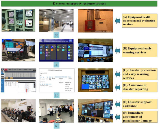 Figure 15. E-system emergency response process. (Source: Research Data). (a) Condition inspection and repair module; (b) Monitoring and remote transmission module; (c) Real-time monitoring and security analysis module; (d) Early warning reporting and disaster relief support module.
 - B.
- The intelligent disaster prevention system constructed in this study had complete system integration, including the fire-fighting radio dispatch system in the whole district, real-time multidirectional wireless calls, independent telephone lines, LINE and SMS push notifications, and real-time audiovisual internal and external disaster relief information reporting and contact. Furthermore, the system was fully integrated into the ICS;
- C.
- One-click trigger method for reporting to relevant units: The entire system can be triggered to rapidly notify relevant internal units and fire brigade through the issuing of a single command. The system can also collect equipment information at the disaster location and display the nearest exit and optimal rescue location for personnel at each location (Figure 16).
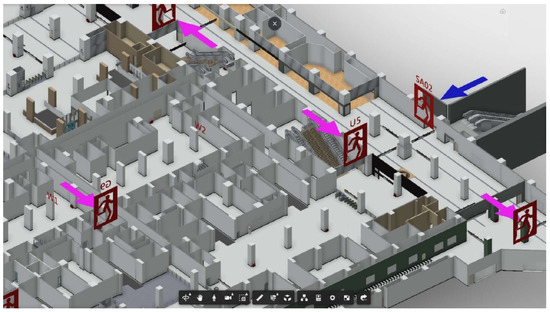 Figure 16. One-click trigger used to identify the nearest exit. (Source: Research Data).
 - D.
- A drill was conducted on National Disaster Prevention Day, simulating several emergency situations such as short circuits of billboard wires resulting from an earthquake, suppression of an indiscriminate violent attack by the military police, and disposal of an explosive by the Criminal Investigation Bureau. Figure 17 is the TV display during the drill simulation. Figure 18 shows the shows of some specific areas of drill on National Disaster Prevention Day in Taipei Main Station.
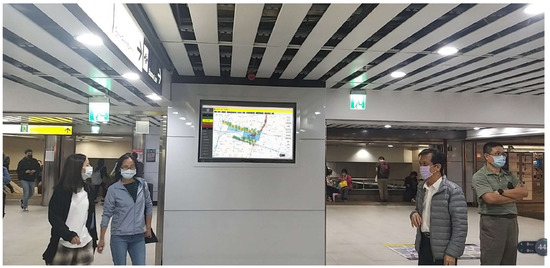 Figure 17. Television display at normal times. (Source: Taipei Main Station Intelligent Joint Disaster Prevention Center, 2021).
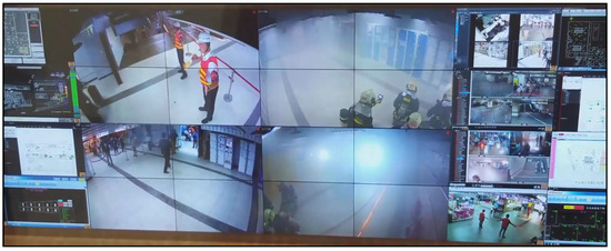 Figure 18. Drill on national disaster prevention day in specific areas of Taipei Main Station. (Source: Taipei Main Station Intelligent Joint Disaster Prevention Center, 2021).
This system has been conducted in a disaster prevention exercise on the National Disaster Prevention Day in 2020. The scene was (1) the fire in an advertising box caused by the earthquake caused a short circuit, and the firefighters carried out disaster relief drills; (2) the indiscriminate violent attack was subdued by the military police (on the (d) Drill simulation of Figure 6); (3) the explosives were dismantled by the Criminal Bureau’s blast squad. It has been verified that the system has excellent function through actual exercises. This “Taipei Main Station Intelligent Disaster Prevention System” has won the Smart Transportation Award in 2020 (Figure 19) [54].
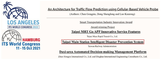
Figure 19.
Smart Transportation Award of “Taipei Main Station Intelligent Disaster Prevention System” (Source: Taipei Main Station Intelligent Joint Disaster Prevention Center, 2020).
6. Conclusions
In this study, a BIM model for Taipei Main Station has been established. The risk factors have been analyzed to formulate the SOP of the emergency response plan. The “Taipei Main Station Intelligent Disaster Prevention System” has been established through a BIM-based CPS. The system adopted Taipei Main Station as an example disaster location. The contributions of this study are as follows:
- A.
- Standardization of disaster prevention and relief reporting, inspection of equipment status, and implementation of a reporting flowchart;
- B.
- Integration and construction of an automated function for one-click trigger reporting;
- C.
- Combination of the ICS with BIM intelligent management.
The cloud management system in this study can currently only apply Taipei Main Station as an example and has already demonstrated the integration effect in this building. In the future, this system can be extended to other stations, such as those of Banqiao, Taichung, and Kaohsiung. The system is expected to expand to various stations for implementation of smart city and transportation integration functions. In the future, mixed reality can also be introduced into the system to guide exit at usual times as well as to assist the public in disaster relief.
Author Contributions
Conceptualization, C.-H.L. and M.-C.H.; methodology, P.-C.H.; software, P.-C.H.; validation, M.-C.H., P.-C.H. and M.-L.Y.; formal analysis, M.-L.Y.; investigation, P.-C.H.; resources, M.-C.H.; data curation, C.-H.L.; writing—original draft preparation, C.-H.L.; writing—review and editing, Y.-C.S.; visualization, C.-H.L.; supervision, Y.-C.S.; project administration, M.-L.Y.; funding acquisition, M.-L.Y. All authors have read and agreed to the published version of the manuscript.
Funding
This research received no external funding.
Institutional Review Board Statement
Not applicable.
Informed Consent Statement
Not applicable.
Data Availability Statement
The data presented in this study are available on request from the corresponding author.
Conflicts of Interest
The authors declare no conflict of interest.
References
- China Electronics Standardization Institute Chinese. Cyber-Physical Systems white Paper; China Electronics Standardization Institute Chinese: Taipei, Taiwan, 2017. [Google Scholar]
- Kim, K.-D.; Kumar, P.R. Cyber–Physical Systems: A perspective at the centennial. Proc. IEEE 2012, 100, 1287–1308. [Google Scholar] [CrossRef]
- Gürdür, D.; Asplund, F. A systematic review to merge discourses: Interoperability, integration and cyber-physical systems. J. Ind. Inf. Integr. 2018, 9, 14–23. [Google Scholar] [CrossRef]
- Hu, F.; Lu, Y.; Vasilakos, A.V.; Hao, Q.; Ma, R.; Patil, Y.; Zhang, T.; Lu, J.; Li, X.; Xiong, N.N. Robust Cyber–Physical Systems: Concept, models, and implementation. Future Gener. Comput. Syst. 2016, 56, 449–475. [Google Scholar] [CrossRef]
- Chen, H. Theoretical foundations for Cyber-Physical Systems: A literature review. J. Ind. Integr. Manag. 2017, 2, 1750013. [Google Scholar] [CrossRef]
- Chen, H. Applications of Cyber-Physical System: A literature review. J. Ind. Integr. Manag. 2017, 2, 1750012. [Google Scholar] [CrossRef]
- Jeng, T. Research on Pilot Applications of BIM Cloud Platform and Strategy Planning to Upgrade AEC Industry to Industry 4.0; National Cheng Kung University Research & Development Foundation, Architecture and Research Building Institute: Tainan, Taiwan, 2016. [Google Scholar]
- Lei, Y.; Rao, Y.; Wu, J.; Lin, C.-H. BIM based cyber-physical systems for intelligent disaster prevention. J. Ind. Inf. Integr. 2020, 20, 100171. [Google Scholar] [CrossRef]
- Cyber-Physical Systems-Are Computing Foundations Adequate? Available online: https://citeseerx.ist.psu.edu/viewdoc/download?doi=10.1.1.84.8011&rep=rep1&type=pdf (accessed on 5 October 2022).
- Xing, K.; Kim, K.P.; Ness, D. Cloud-BIM nnabled Cyber-Physical data and service platforms for building component reuse. Sustainability 2020, 12, 10329. [Google Scholar] [CrossRef]
- Chen, B.; Schmittner, C.; Ma, Z.; Temple, W.G.; Dong, X.; Jones, D.L.; Sanders, W.H. Security analysis of urban railway systems: The need for a Cyber-Physical perspective. In Proceedings of the Computer Safety, Reliability, and Security, Cham, Switzerland, 9 December 2015; pp. 277–290. [Google Scholar] [CrossRef]
- Basile, D.; Giandomenico, F.D.; Gnesi, S. Statistical model checking of an energy-saving cyber-physical system in the railway domain. In Proceedings of the Symposium on Applied Computing, Marrakech, Morocco, 3 April 2017; pp. 1356–1363. [Google Scholar] [CrossRef]
- Monedero, Í.; Barbancho, J.; Márquez, R.; Beltrán, J.F. Cyber-Physical System for environmental monitoring based on deep learning. Alessandro Gardi Roberto Sabatini Sens. 2021, 21, 3655. [Google Scholar] [CrossRef]
- Deka, L.; Khan, S.M.; Chowdhury, M.; Ayres, N. Transportation Cyber-Physical System and its importance for future mobility. Transp. Cyber-Phys. Syst. 2008, 1–20. [Google Scholar] [CrossRef]
- Képes, K.; Leymann, F.; Zimmermann, M. Situation-Aware updates for Cyber-Physical Systems. In Proceedings of the Service-Oriented Computing, Cham, Switzerland, 7 October 2020; pp. 12–32. [Google Scholar] [CrossRef]
- Cancila, D.; Zaatiti, H.; Passerone, R. Cyber-Physical System and Contract-Based Design: A Three Dimensional View. In Proceedings of the WESE’15: Workshop on Embedded and Cyber-Physical Systems Education, Amsterdam, The Netherlands, 4 October 2015. [Google Scholar] [CrossRef]
- Bonci, A.; Carbonari, A.; Cucchiarelli, A.; Messi, L.; Pirani, M.; Vaccarini, M. A cyber-physical system approach for building efficiency monitoring. Autom. Constr. 2019, 102, 68–85. [Google Scholar] [CrossRef]
- Bigley, G.A.; Roberts, K.H. The Incident Command System: High-Reliability Organizing for Complex and Volatile Task Environments. Acad. Manag. J. 2001, 44, 1281–1299. [Google Scholar] [CrossRef]
- Fang, K.; Lin, S. An Integrated Approach for Modeling Ontology-Based Task Knowledge on an Incident Command System. Sustainability 2019, 11, 3484. [Google Scholar] [CrossRef]
- Auf der Heide, E. Disaster Response: Principles of Preparation and Coordination. In Disaster Response: Principles of Preparation and Coordination; CV Mosby Company: Toronto, ON, Canada, 1989; Available online: http://bases.bireme.br/cgi-bin/wxislind.exe/iah/online/?IsisScript=iah/iah.xis&src=google&base=DESASTRES&lang=p&nextAction=lnk&exprSearch=13673&indexSearch=ID (accessed on 13 September 2020).
- Scholz, M.; Gordon, D.; Ramirez, L.; Sigg, S.; Dyrks, T.; Beigl, M. A Concept for Support of Firefighter Frontline Communication. Future Internet 2013, 5, 113–127. [Google Scholar] [CrossRef]
- Bjelland, H.; Njå, O.; Heskestad, A.W.; Braut, G.S. Emergency preparedness for tunnel fires—A systems-oriented approach. Saf. Sci. 2021, 143, 105408. [Google Scholar] [CrossRef]
- Wang, Q.; Ma, T.; Hanson, J.; Larranaga, M. Application of incident command system in emergency response. Process Saf. Prog. 2012, 31, 402–406. [Google Scholar] [CrossRef]
- Feng, J.R.; Gai, W.-M.; Yan, Y.-B. Emergency evacuation risk assessment and mitigation strategy for a toxic gas leak in an underground space: The case of a subway station in Guangzhou, China. Saf. Sci. 2021, 134, 105039. [Google Scholar] [CrossRef]
- Gai, W.-M.; Du, Y.; Deng, Y.-F. Evacuation risk assessment of regional evacuation for major accidents and its application in emergency planning: A case study. Saf. Sci. 2018, 106, 203–218. [Google Scholar] [CrossRef]
- Gai, W.-M.; Du, Y.; Deng, Y.-F. Regional evacuation modeling for toxic-cloud releases and its application in strategy assessment of evacuation warning. Saf. Sci. 2018, 109, 256–269. [Google Scholar] [CrossRef]
- Jiang, C.; Li, W.; Hu, C.; Xiong, Y.; Ding, H.; Chow, W.K. Emergency evacuation in places for public entertainment in Mainland China. Build. Environ. 2009, 44, 169–176. [Google Scholar] [CrossRef]
- Zio, E. The future of risk assessment. Reliab. Eng. Syst. Saf. 2018, 177, 176–190. [Google Scholar] [CrossRef]
- Chan, T.C.; Killeen, J.; Griswold, W.; Lenert, L. Information technology and emergency medical care during disasters. Acad. Emerg. Med. 2004, 11, 1229–1236. [Google Scholar] [CrossRef]
- Falakh, F.; Setiani, O. Hazard identification and risk sssessment in water treatment plant considering environmental health and safety practice. E3S Web Conf. 2018, 31, 06011. [Google Scholar] [CrossRef]
- Janzer, G. Law Enforcement and the Effective Use of the Incident Command System; University of Wisconsin Platteville: Prattville, WI, USA, 2021; Available online: http://digital.library.wisc.edu/1793/81846 (accessed on 13 September 2022).
- Marion County Kansas. Emergency Management. 2021. Available online: https://www.marioncoks.net/sites/g/files/vyhlif6456/f/uploads/marion_county_base_plan_sept_2021_-_with_wording_update_11_2021.pdf (accessed on 13 September 2022).
- Fang, S.; Xu, L.; Pei, H.; Liu, Y.; Liu, Z.; Zhu, Y.; Yan, J.; Zhang, H. An Integrated Approach to Snowmelt Flood Forecasting in Water Resource Management. IEEE Trans. Ind. Inform. 2014, 10, 548–558. [Google Scholar] [CrossRef]
- Li, L.; Wang, B.; Wang, A. An emergency resource allocation model for maritime chemical spill accidents. J. Manag. Anal. 2014, 1, 146–155. [Google Scholar] [CrossRef]
- Cheung, W.-F.; Lin, T.-H.; Lin, Y.-C. A Real-Time construction safety monitoring system for hazardous gas integrating wireless sensor network and building information modeling technologies. Sensors 2018, 18, 436. [Google Scholar] [CrossRef]
- Cheng, M.-Y.; Chiu, K.-C.; Hsieh, Y.-M.; Yang, I.T.; Chou, J.-S.; Wu, Y.-W. BIM integrated smart monitoring technique for building fire prevention and disaster relief. Autom. Constr. 2017, 84, 14–30. [Google Scholar] [CrossRef]
- Hosseini, O.; Maghrebi, M. Risk of fire emergency evacuation in complex construction sites: Integration of 4D-BIM, social force modeling, and fire quantitative risk assessment. Adv. Eng. Inf. 2021, 50, 101378. [Google Scholar] [CrossRef]
- Bourhim, E.L.M.; Cherkaoui, A. Efficacy of virtual reality for studying people’s pre-evacuation behavior under Fire. Int. J. Hum. Comput. Stud. 2020, 142, 102484. [Google Scholar] [CrossRef]
- Darko, A.; Chan, A.P.C.; Yang, Y.; Tetteh, M.O. Building information modeling (BIM)-based modular integrated construction risk management—Critical survey and future needs. Comput. Ind. 2020, 123, 103327. [Google Scholar] [CrossRef]
- Kasereka, S.; Kasoro, N.; Kyamakya, K.; Doungmo Goufo, E.-F.; Chokki, A.P.; Yengo, M.V. Agent-Based Modelling and Simulation for evacuation of people from a building in case of fire. Procedia Comput. Sci. 2018, 130, 10–17. [Google Scholar] [CrossRef]
- Rüppel, U.; Schatz, K. Designing a BIM-based serious game for fire safety evacuation simulations. Adv. Eng. Inf. 2011, 25, 600–611. [Google Scholar] [CrossRef]
- Wei, C.-C. The Research of the Disaster Prevention and Protection System of Taipei City-Take Earthquake Disaster as an Example; National Central University: Taoyuan, Taiwan, 2008; Available online: https://hdl.handle.net/11296/4qtmkt (accessed on 13 September 2022).
- Ministry of Transportation Disaster Emergency Notification Operation Points. Available online: https://motclaw.motc.gov.tw/webMotcLaw2018/Law/Info?LawID=C0199013&stop=0 (accessed on 13 September 2022).
- Joint Emergency Operation Center of Taipei Main Station. Standard Operating Procedure for Emergency Response of the Joint Emergency Operation Center of Specific Areas in Taipei Main Station; Joint Emergency Operation Center of Taipei Main Station, Ed.; Taipei Main Station: Taipei, Taiwan, 2016; Volume 10532196400. [Google Scholar]
- Station Front Metro Mall. Liability for Guarantee of Fire Protection Plan of Site Utilization Cooperative in Station Front Metro Mall. Available online: http://www.gis-bim.com/files/documents/b28f9f9f-4549-4c0f-9bde-176ac5b1675c.pdf (accessed on 13 September 2022). (In Chinese).
- Chen, H. Common Fire Protection Plan for Specific Areas of Taipei Main Station. Available online: http://www.gis-bim.com/files/documents/06549dd2-c8a5-44fd-9fde-d881b13446b3.pdf (accessed on 13 September 2022). (In Chinese).
- Eslite Spectrum Corporation. Annual Fire Protection Plan. 2018. Available online: http://www.gis-bim.com/files/documents/ccaf4f42-8867-4bf7-8d5b-f51864fc1e1c.pdf (accessed on 13 September 2022). (In Chinese).
- Taipei City Government. Report on Special Building Modification and Disaster Prevention Plan of Taipei Main Station Building. Available online: http://www.gis-bim.com/files/others/8594f518-91cf-40ff-9380-41b1fa5ed207.zip (accessed on 13 September 2022). (In Chinese).
- Taipei Station, Taiwan High-speed Rail. Fire Protection Plan for Taiwan High Speed Rail Taipei Station. Available online: http://www.gis-bim.com/files/documents/0b8503e6-2de8-4222-87a8-ca5420276504.pdf (accessed on 13 September 2022). (In Chinese).
- Breeze. Breeze Fire Protection Plan. 2018. Available online: http://www.gis-bim.com/files/documents/ead01e94-0103-4fe4-a621-5bc32b2fa462.pdf (accessed on 13 September 2022). (In Chinese).
- Taipei Rapid Transit Corporation Business Division Management Center. Fire Protection Plan of Zhongshan Metro Mall of Taipei Rapid Transit Corporation. 2018. Available online: http://www.gis-bim.com/files/documents/3b74a3bd-cda6-497d-8533-57d9313bd103.pdf (accessed on 13 September 2022). (In Chinese).
- Liability for Guarantee of Site Utilization Cooperative in Station Front Metro Mall. Fire Protection Plan of Station Front Metro Mall. 2017. Available online: http://www.gis-bim.com/files/documents/2d6047f8-7cc2-413b-b1e5-5a0667e31506.pdf (accessed on 13 September 2022). (In Chinese).
- Taiwan Railway Administration. Emergency Response Plan. 2019. Available online: http://www.gis-bim.com/files/documents/d76916b6-7155-4553-8827-5273effa2e78.pdf (accessed on 13 September 2022). (In Chinese).
- Intelligent Transportation Society of TAIWAN. Smart Transportation Awards 2020; Intelligent Transportation Society of TAIWAN, 2022. Available online: http://www.its-taiwan.org.tw/ch/e-1.asp?c_no=1345 (accessed on 13 September 2022). (In Chinese).


Publisher’s Note: MDPI stays neutral with regard to jurisdictional claims in published maps and institutional affiliations. |
© 2022 by the authors. Licensee MDPI, Basel, Switzerland. This article is an open access article distributed under the terms and conditions of the Creative Commons Attribution (CC BY) license (https://creativecommons.org/licenses/by/4.0/).