Article

Reconstruction of Ancient Lake after Peat Excavation—A Case Study about Water Quality

by
Ryszard Staniszewski
1,*,
Przemysław Frankowski
2,
Dariusz Kayzer
3,
Janina Zbierska
1 and
Krzysztof Achtenberg
1
1
Department of Ecology and Environmental Protection, Poznan University of Life Sciences, Piatkowska Str. 94C, 60-649 Poznan, Poland
2
AFIRMA Ltd., Wojnowo, 62-095 Murowana Goslina, Poland
3
Department of Mathematical and Statistical Methods, Poznan University of Life Sciences, Wojska Polskiego Str. 28, 60-637 Poznan, Poland
*
Author to whom correspondence should be addressed.
Appl. Sci. 2021, 11(9), 4213; https://doi.org/10.3390/app11094213
Submission received: 6 April 2021 / Revised: 26 April 2021 / Accepted: 4 May 2021 / Published: 6 May 2021

Abstract

:
According to regulations in some European countries, peat is treated as a fossil fuel or soil for mushroom horticulture and its management is subject to the law for mining activities. As a result of the exploitation of peat bogs, the cutaway or pit lakes remain, which when properly prepared can be local water resources. Such post-peat water bodies can be used for recreation and they can be particularly important in areas struggling with water deficiency in the rural landscape. Maintaining good water quality in such reservoirs requires a number of preparatory works, including the removal of the remaining organic matter that would rest at the bottom of the new pit lake, affecting the water quality. Studies of water quality and aquatic plant communities in the studied post-peat lake were carried out during the period 2012–2014 in order to determine the changes in water quality and the usefulness of water for cyprinids. Aquatic plant communities identified in the reservoir showed a simplified species composition, characteristic of initial communities, and they occupied small areas in the water and on the banks. It has been shown that water quality parameters of the studied water body were stable and corresponded to thresholds established for cyprinids.

1. Introduction

Saving water resources is a crucial issue in the twenty first century. Increasing water scarcity in different parts of the world has become an urgent political and economic problem. The measures proposed hitherto include the reduction in water consumption in all aspects of human life and increasing water retention, wherever possible [1]. Additionally, water shortage is often connected with poor water quality, which limits its use in agriculture or recreation [2].
Specific possibilities for water saving occur in areas with abandoned open pit mines, especially after the excavation of brown coal and peat bog. Post mining lakes are still more frequent in Europe (Germany, Poland, Ireland) and Australia due to the possibility of maintaining water resources in areas that formerly suffered water shortage related to mining activities. Studies on mining’s impact on the environment and its consequences after the cessation of excavation are perceived as more environmentally important with every decade. Among them, an interesting subject is the role of post-mining reservoirs and their subsequent impact on the environment [3,4,5,6]. Post-mining reservoirs have become frequent elements of the landscape in many countries [7,8,9]. Studies of the water quality of such reservoirs create some methodological problems, especially under acid mine drainage conditions and the maintenance of optimal water quality in such objects is very important for local communities [8].
Several authors have described the impact of climate changes on water cycle and water quality parameters [10,11,12,13,14]. Many regions of the world were affected by droughts in recent decades and the insecurity of water availability has stimulated the search for preventing measures [2]. In areas with water shortage, pit lakes can be important sources of water for agriculture and for recreation, provided that the water quality is satisfactory. Central Poland, especially the Wielkopolska region, is characterized with visible water shortage in agriculture, decreasing water levels in lakes, low precipitation (about 500 mm per year) and is inconvenient for farmers’ distribution of rainfalls. This situation is partly related to water management strategies in municipalities and in watersheds [15,16]. The rebuilding and recultivation of small water reservoirs in rural landscape and the creation of pit lakes can be the partial answer to meet the goals of the EU Water Framework Directive [17]. When a peat lake is planned in the place of former mining activities, it is possible to figure out the pit dimensions to facilitate technical works according to establishing close to natural environmental conditions (reservoir morphology, removal of organic matter). It is possible to limit the rate of disappearing water reservoirs in the rural landscape by means of rebuilding former water bodies and such projects are especially needed in areas with water shortage, like central Poland.
The scientific aims of undertaken studies were to assess the quality of water in the newly built post-peat reservoir and to determine its importance in shaping local biodiversity, as well as to identify the water and littoral plants dominating in the first years after establishing the reservoir. The practical aim was to check the sensibility of building a water reservoir in the place of a former eutrophic post-glacial lake and the possibility of maintaining its good water quality.

2. Materials and Methods
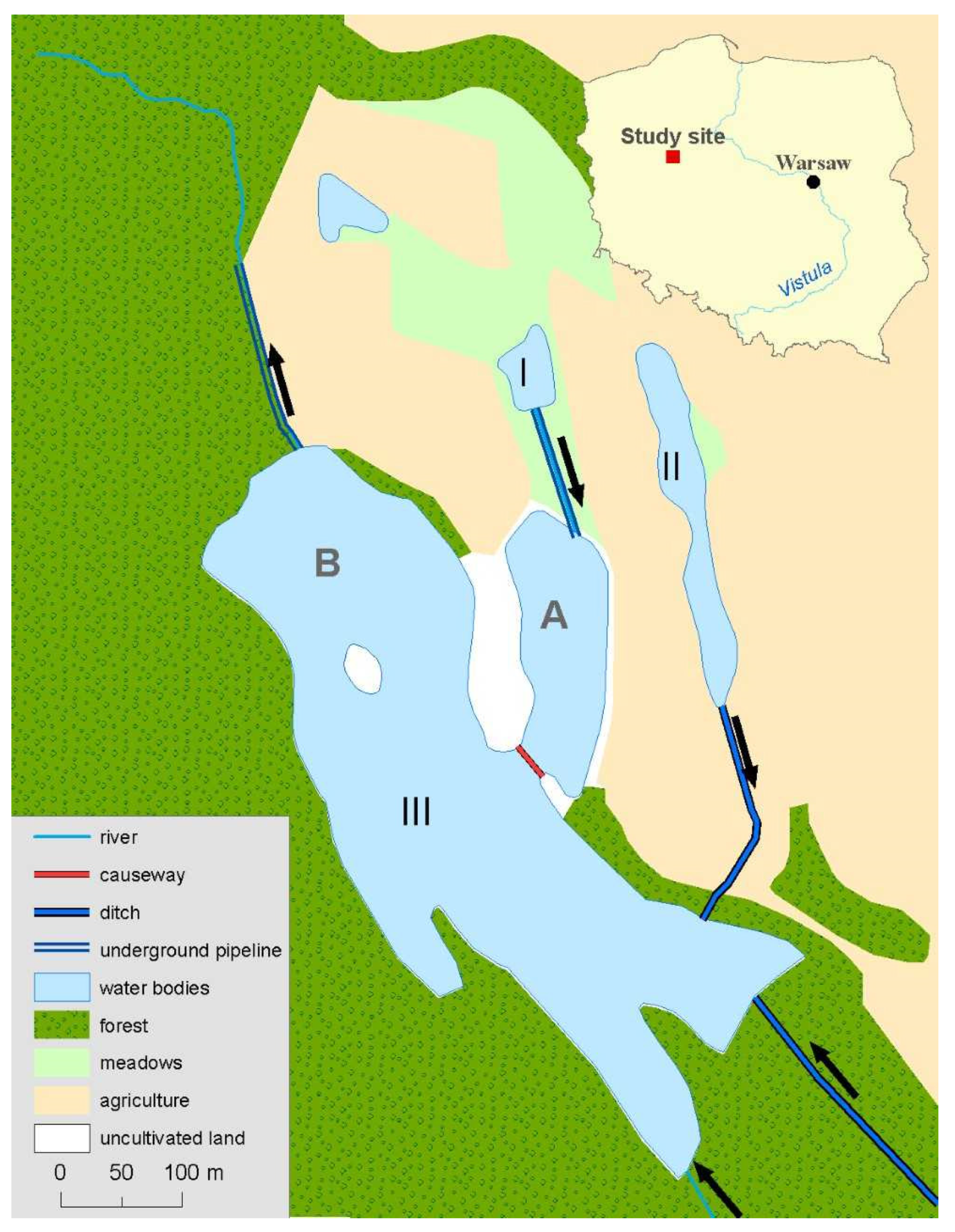
2.1. Study Site

Nienawiszcz is a village in the Wielkopolska (Greater Poland) region (Poland) with areas covered by forests, arable fields, meadows, waters and peat bogs. The peat-lake studied was localized at 52°40′31.6″ N, 16°59′05.0″ E southwest from the village and was constructed in consecutive steps. The geology of the watershed is the effect of Baltic ice deglaciation in the Holocene and in the site of an ancient lake, peat and gyttja developed. To the depth of about 120 m, there are tertiary and quaternary mineral deposits. The lowest are tertiary formations of silt and fine sands with lignite layers, which are the lowest parts of the Miocene deposit. Above them there is a layer of sands with a thickness of 10–20 m, locally overgrown with muddy sediments. These deposits are covered by a layer of clay and silt sediments with a coal layer of 10–30 m in thickness. Within it, there are local sandy layers—silty sands, sometimes sandstones. Another layer consists of Miocene and Pliocene clays with strongly differentiated thickness [18]. The subquaternary layer is strongly differentiated and is located at a height of approximately 30–70 m above sea level. The geology of study site is presented in Figure 1.
All works on the post-peat lake were carried out in three steps:
  • Identification of the soil and water conditions of the area, physicochemical analyses of peat;
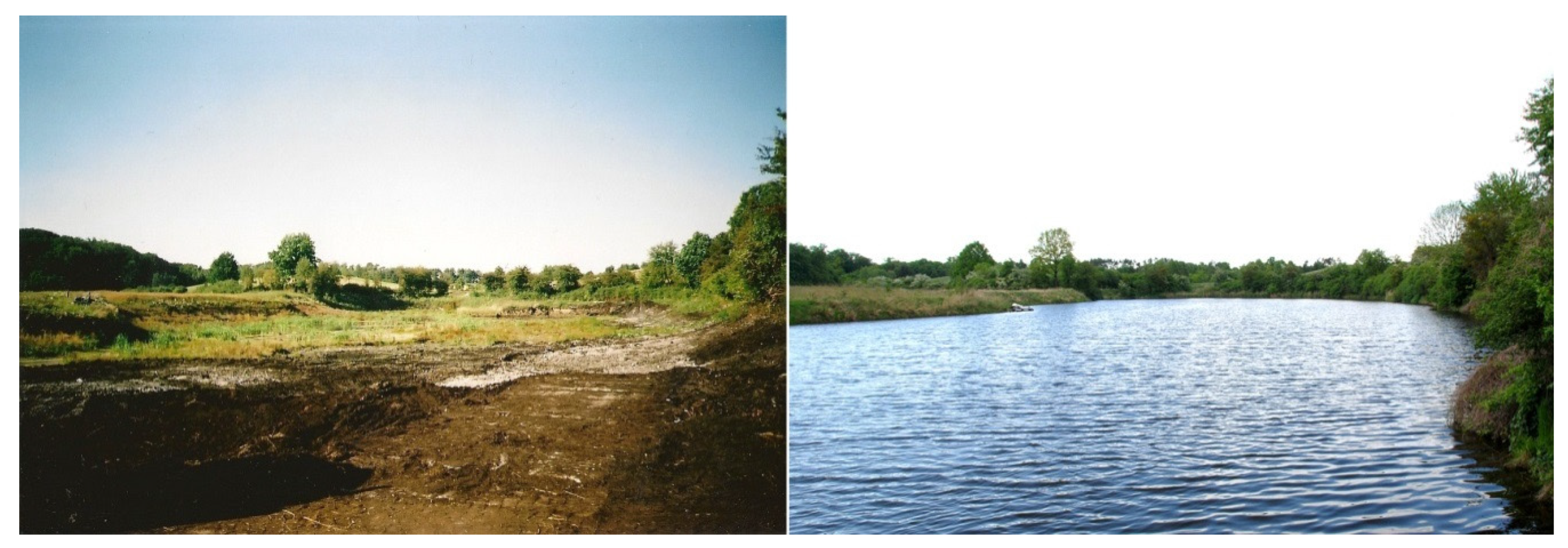
  • Exploitation of the peat and the simultaneous construction of the reservoir (the construction was carried out in two stages—during the period 2004–2007, when peat was exploited in the northeastern part of lake, which after being separated by a causeway in 2007 was flooded with water (A) (Figure 2); and the remaining part of the reservoir (B) (Figure 2) during the period 2007–2012 was drained by pumping out the water in order to exploit the dry peat),
  • From July 2012 to October 2015, parts A and B were connected by the removal of the causeway and filling the whole reservoir with water, further analysis of water quality and plants species structure.

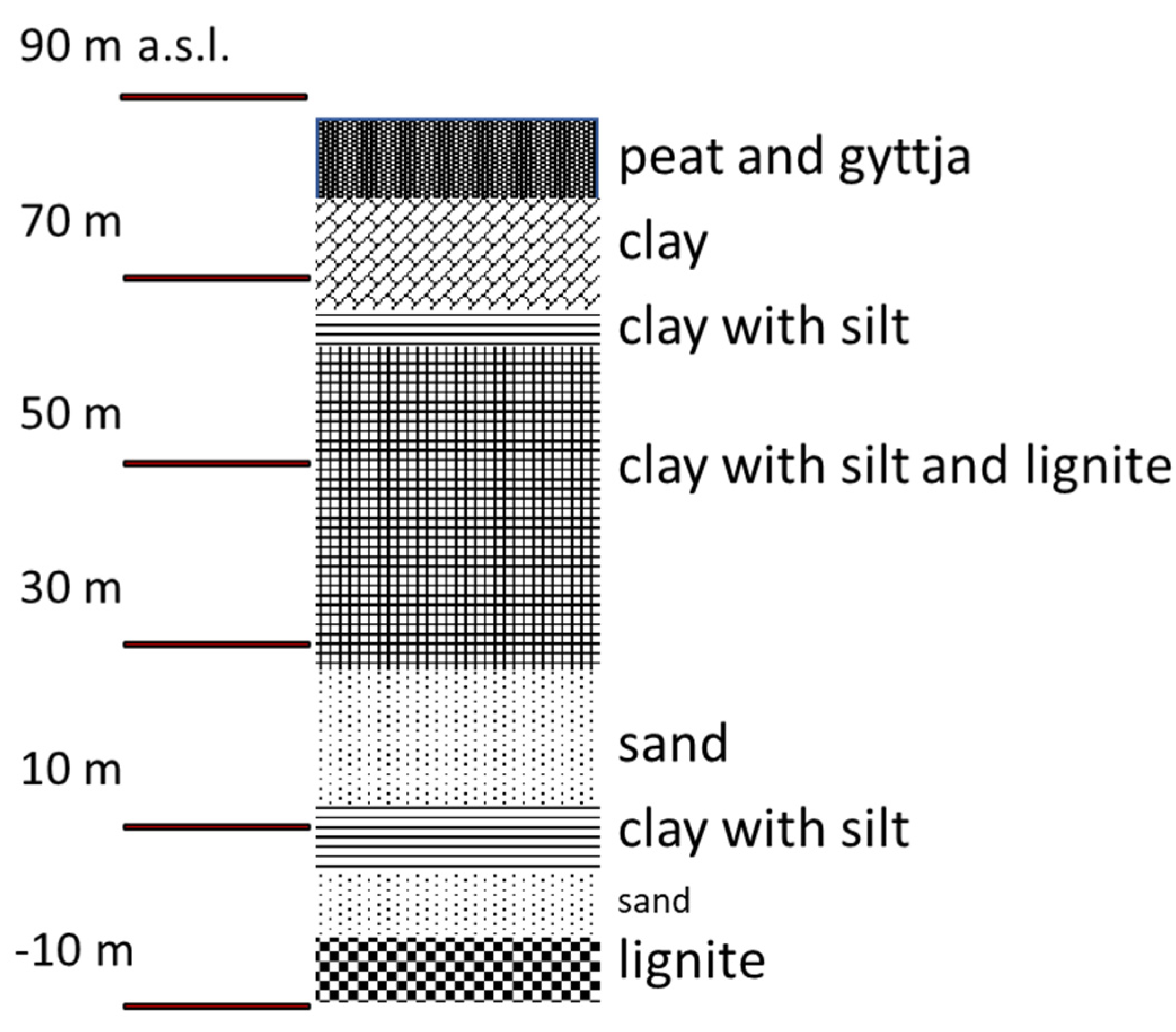
2.2. Peat Characteristics

The drilling works included 33 exploration holes in near-surface areas (depths from 1.0 to 4.0 m) made using an INSTORF auger drill, documenting the quantity and quality of the deposit. During drilling of the holes, peat samples were taken (at every 1 m) and tested in a credited laboratory of Aquanet Ltd. in Poznan.
Peat moisture in a large part of the Nienawiszcz deposit ranged from 79 to 84%, peat thickness varied from 0.4 to 3.4 m, water capacity was 420% on average, porosity was 8%, volumetric weight was 150 g/L, pH of 6.1–7.4, degree of decomposition was above 40%, and the ash content was significantly diverse, ranging from 11 to 39% (Table 1).
Peat was mined using the opencast method and extracted from anaerobic layers, free of pathogens and nematodes, then it was used directly for the production of casing soil for growing mushrooms. The turf, useful for plant rooting, was composted and then became a component of horticultural soils used for the cultivation of flowers and rolled grass lawn.
Below the Nienawiszcz peat layer, a calcareous gyttja was found, formed as a result of deposits of sediments in lake reservoirs. The gyttja consisted of three basic elements: organic mass of plant residues and plankton processed by benthic fauna, calcium carbonate precipitated from water or deposited biologically by plants and crustaceans and mineral deposit as a result of sedimentation. In the studied area, the level of CaO in calcareous gyttja was between 38 and 43%. Due to obtained environmental and mining permissions, gyttja was not removed after the excavation of peat.

2.3. Shaping of the Post-Peat Reservoir

The construction of the studied reservoir (III) was carried out in several stages and was preceded by the construction of two smaller post-peat reservoirs I and II (Figure 2). After peat exploitation in the northeastern part, both parts of the reservoir were separated by a causeway and part A was flooded with water. The remaining part (B) was then drained by pumping out water in order to exploit the dry peat. After the extraction of the peat deposit, the reclamation work began, including the appropriate shaping of the surrounding area and bottom, levelling the banks and softening the slopes of the planned water reservoir and then, filling it with water. The reservoir is filling out a depression formerly occupied by lake and its banks are not reinforced in any part. Since the excavated deposit was formed as a result of the eutrophication of the former glacial lake, the construction of the water reservoir in this place was in a sense the reconstruction of an old, natural reservoir of glacial origin and contributed to the regulation of water conditions in this area.
Prior to the peat deposit exploitation, the groundwater level was regulated by a system of drainage ditches, and the outflow of water went in the northwestern direction, through a 30 cm diameter pipeline with a culvert at the northern boundary of the area. Additionally, the watercourse Slomowo was periodically (during months with relatively high precipitation) supplying the reservoir with water, as shown in Figure 2. Precipitation in 2015 (446 mm) was lower than average (523 mm during the period 1981–2010).
The slopes of the reservoir were made of moraine clay and create an impermeable basin, limiting the water penetration into the surrounding land. The water level in the reservoir corresponds to the natural hydrological conditions, determined by the land characteristics. The available resources of the reservoir are positively influenced by numerous natural springs occurring around the lake.
As a result of the undertaken works, a unique water reservoir with natural lake slopes and a very extensive and picturesque coastline was formed. The post-mining land was naturally filled with water from local springs, through the existing system of drainage ditches and precipitation. There was no need for damming up the water in this case, as there is a constant inflow of groundwater in this area, supplemented by periodical surface inflow.
After the peat deposit was excavated, a post-mining water reservoir was created (Figure 3). The average depth of post-peat lake was equal to 1.64 m and the maximum depth was 3.99 m. The length of the coastline was equal to 2425 m. The volume of reservoir was about 175,322 m3 and the area equal to 11 ha (including island) (Table 2). The total area of the water surface was equal to 10.71 ha. The maximum water level was determined by the lowest edge of the culvert positioned at 87.09 m above sea level. The reservoir has a diversified shoreline, covered with forests, meadows, and arable lands; it also has an island, bays of different depths and four peninsulas covered with grass.

2.4. Watershed

The direct watershed (73.62 ha) (Table 3.) was dominated by forests, which covered 86.1% of the described area. The remaining areas were covered by arable lands (11.2%), grasslands (1.6%) and water bodies (1.1%). The highest elevation in this sub-basin was 120.5 m and the lowest point was 87.1 m above sea level. The total watershed area (317.19 ha) was also covered mostly by forests (82.9%), arable lands (14%), grasslands (1.7%), water bodies (1.2%) and urban areas (0.2%).

2.5. Water Quality Analyses

Water samples to be analyzed were collected four times per year from the surface layer of both, parts A (12 samples, 2012–2014) and B (8 samples, 2013–2014) of reservoir III (Figure 2). The following physico–chemical parameters of water were analyzed:
  • Dissolved oxygen, biochemical oxygen demand after 5 days—electrochemically;
  • Conductivity—electrometrically;
  • Nitrates, nitrites, ammonium, soluble reactive phosphates—spectrophotometrically;
  • Total nitrogen—by the Kjeldahl method;
  • Total phosphorus, copper, zinc—by inductively coupled plasma ionization mass spectrometry;
  • pH reaction—potentiometrically.
The samples were stored in an ice box and analyzed within 24 h from the time of collection. The analyses were made at the certified laboratory of the Aquanet Laboratorium Poznan. Evaluation of the water quality according to the needs of cyprinids species was based on the specifications given in the Journal of Laws 2002 (No. 176, item 1455). The parameters considered were pH reaction, BOD-5, concentrations of total phosphorus, ammonium, nitrites, dissolved copper, total zinc and dissolved oxygen.

2.6. Identification of Plant Species

Geobotanical studies started in the year 2011 and continued until 2014 using the Braun–Blanquet method [19] for the identification of plant associations present in terrestrial and aquatic ecosystems, which can be used for the evaluation of ecological conditions of biota. It was based on the cover–abundance scale, where plant cover was estimated using a 1–5 scale, supplemented by + if five or less specimens were present, r for 1 specimen in the surveyed area (very rare) [20]. Studies of aquatic plants were undertaken during summer seasons and the identification of particular plant species and communities was based on the key of Rich and Jermy [21].

2.7. Fish Population

The rebuilt reservoir was stocked by an investor with several species from the cyprinids group as carp (Cyprinus carpio), tench (Tinca tinca), crucian carp (Carassius carassius), grass carp (Ctenopharyngodon idella) and roach (Rutilus rutilus). Additionally, fish from other groups were stocked in the reservoir such as eel (Anguilla anguilla) and pike (Esox lucius) to obtain a population structure typical for the region. Species extinct in this area, sturgeon (Acipenser sturio), was also stocked in the lake water. The reservoir from the beginning was used for angling recreation with no-kill rules only. The presence of dominant fish species was checked in the years 2017–2018 using interviews with anglers.

2.8. Statistical Analyses

After data collection, the following analyses were made: statistical analyses of water quality parameters according to the stabilization of water parameters after the connection of both parts; the assessment of post-peat lake usefulness for fish existence; and the evaluation of water characteristics based on the presence of aquatic plants.
To compare parts A and B, canonical variate analysis (CVA) was performed using the results of water quality parameters. This method consists in the transformation of the analyzed matrix into a set of new variables, which carry similar information but are distributed in a multivariate Euclidean space [22,23,24].
Elements of the CVA matrices included differences between mean values of measured parameters in various experimental objects and means for all objects. In this case, the experimental object was defined as the average annual values of the studied parameters for parts A or B (localized in part A and B of the reservoir, respectively) in a particular year.

3. Results

3.1. Aquatic Plants and Plant Communities Identified in Reservoir

During studies, macrophytes were in their initial state of development, however, actual species composition and the first identified plant communities were the answer sought for water trophy in the reconstructed lake. Until the year 2014 in the post-peat lake Nienawiszcz, 30 plant species were recorded in the water and on the bankside. The most frequent taxa were reeds, sedges, horsetails, mints and in some places pond-lilies. Only 16 sites of small areas (a few square meters) with initially developed phytocenosis of aquatic plants were found in the reservoir with three poorly developed plant communities, from one class Phragmitetea. Dominant communities were Phragmitetum (11 areas), Caricetum ripariae (four areas) and Caricetum acutiformis (in one site), all characteristic of eutrophic waters. The most frequently identified plants in the reservoir were reeds (Phragmites australis), Carex riparia, Carex acutiformis, Typha latifolia, Polygonum amphibium and Equisetum palustre. They are tolerant both for low and high concentrations of trophic substances, but generally prefer eutrophic waters. Most of aquatic taxa covered narrow belts of water line dispersed around water body.

3.2. Water Level

Due to the impermeable substrate made of clay, even in years with low precipitation, the water level was stable. The water level was stable in 2013 and 2014 with the medium values of 86.62 and 86.91 m a.s.l., respectively. The water level amplitude during the period 2012–2015 was equal to 1.34 meters and the water table level varied from 85.75 m a.s.l. in August 2012 to 87.09 m a.s.l. in May 2014. The median for the whole time of observations was equal to 86.71 m a.s.l. and such a level was observed in July 2013. The water level elevation in the studied lake was similar to that of the time when the water level was below peat surface (ranged from 86.35 to 87.54 m a.s.l).

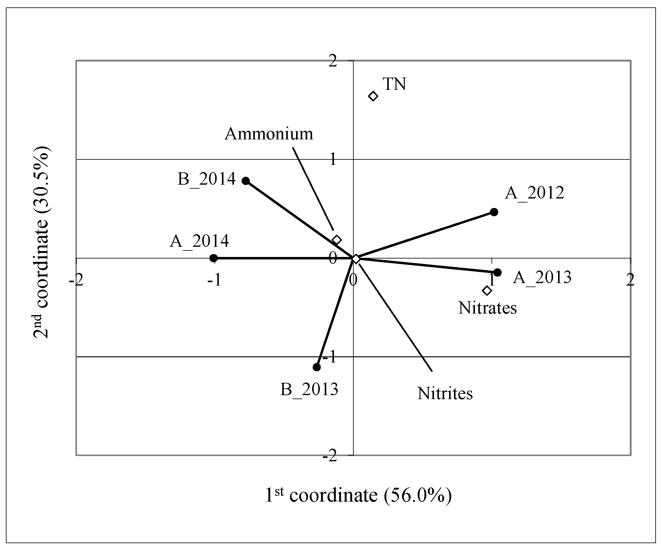
3.3. Water Quality and Fish Population

The results of physico–chemical analyses of water in parts A and B of the reservoir before and after their connection showed that the water quality was appropriate for the fish population, especially cyprinids (carp family). The pH level measured in the pit lake ranged from 7.7 to 8.5 in part A and from 7.8 to 8.4 in part B. The concentration of the total phosphorus ranged from 0.03 to 0.28 and from 0.03 to 0.24 mg P/L (parts A and B, respectively), with a mean value after the connection equal to 0.082 mg P/L (Table 4). Biochemical oxygen demand ranged from 2.3 to 9.0 in part A, and from 2.1 to 5.2 in part B. Conductivity was changeable, and in part A, reached a maximum of 0.880 mS/cm in 2012, then declined to a maximum equal to 0.694 mS/cm in 2014. The maximum value of conductivity in part B was observed in 2013 and was equal to 0.726 mS/cm. The average concentration of total nitrogen varied among years and parts of the reservoir with the maximum in part A (2012) equal to 3.2 mg N/L and the minimum also observed in part A (2013) and equal to 1.3 mg N/L. In 2014, in both parts, the average concentration was 2.6 mg N/L.
During the period 2017–2018, the following native fish species were observed: roach, perch, pike, bleak and non-native Gibel carp (Carassius gibelio).

4. Discussion

Due to the lack of similar post-peat reservoirs, it was impossible to compare the obtained results with other published data. The ponds in the pits left after the excavated peat had another origin and they were filled with groundwater, precipitation and occasionally surface runoff, without connection with local watercourses or surrounding water bodies. In some regions of Ireland and Poland, cutaway peatland lakes were studied by several authors [25,26]. Such water bodies were different from the Nienawiszcz post-peat reservoir because due to the excavation method applied, part of the peat was left, which affected the water quality parameters and the former lake was not restored. In cutaway lakes and in the Nienawiszcz reservoir, the susceptibility for trophic degradation is high and the presence of aquatic plants can stabilize the transparency of the water column. The analysis of the impact of the studied reservoir on landscape stability [9] has shown that the construction of water reservoirs and simultaneous afforestation can improve the diversification of the landscape and its functionality. Around the lake, forests occupied 86.1% of the area and despite the low water level in the surrounding water bodies, the reconstructed lake was filled with water during the period of the study; thus, it can be perceived as a water reserve for the surrounding areas. The studied reservoir was used for recreational purposes for local inhabitants and for the maintenance of biodiversity in the area. Similar aims for pit lakes were made after mining pit lakes in several countries and their role in obtaining a sustainable aquatic ecosystem using the ecological approach was emphasized [27]. Clerici and others [28] found that the presence of forests is helpful in the regulation of local climate conditions and this circumstance should be very helpful in the stabilization of the water level and quality parameters. Additionally, the pit lake morphology was reconstructed in the shape of a previous ancient reservoir, thus banks were not so steep as in the case of cutaway lakes, which can be dangerous for recreation [6].

4.1. Dominant Aquatic Plants and Communities

Communities observed in waters were Phragmitetum, Caricetum ripariae and Caricetum acutiformis. The common reed community (Phragmitetum) plays an important role in the overgrowing of reservoirs and have high phytomass production, which could be a problem for the reservoir if taxa will spread to the open water. It can be found in mineral and peat-bogged habitats with a wide range of water trophic statuses. The Caricetum ripariae is present in ditches, canals, moors, lakes, ponds and old riverbeds. It plays an average role in the overgrowth of water bodies and prefers eutrophic waters. Caricetum acutiformis is present in eutrophied lakes, ponds and in peat bogs, and plays a role in the final stage of water overgrowth [29]. The presence of macrophytes can additionally improve water transparency and oxygenation in the reservoir [30]. Additional surveys on aquatic plants were made in the year 2017 and differences were not observed in comparison to botanical data gathered in presented studies (for the year 2014). The increase in plant cover was low and this ratio was estimated for about 2 percent. The removal of all the peat deposit was necessary to maintain the good quality of lake water. In the typical procedure part of peat can remain and cutaway reservoirs can be covered by aquatic plants very quickly as in Przebedowo Lake (Wielkopolska region, Przebędowo, Poland), which was intensively covered by macrophytes in the year of putting into service.
It can be presumed, that decades after establishment of this lake, it initiated natural processes in the riparian zone which will result in the development of aquatic plant classes typical for peat lakes such as Phragimitetea, Lemnetea minoris, Potametea and mosses from the Sphagnopsida class [31,32].

4.2. Physico–Chemical Parameters of Water

The concentration of nitrites and the value of BOD-5 were high in the post-peat reservoir, however, they did not exceed the limits for carps (Table 4). In autumn 2012, in part A, an increase in BOD-5 was recorded (9 mg O2/L), which indicated a high load of organic matter. In the other periods, biochemical oxygen demand did not exceed 6 mg O2/L, which was admissible for inland waters being the habitat of fish population (especially cyprinids), even under natural conditions. Differences between the annual averages of the studied parameters were calculated and used in further analyses (Table 1). Figure 4 presents the results of canonical variate analysis presenting study objects (part A in years 2012–2014 and part B in years 2013–2014) in relation to the selected physico–chemical elements, characterizing the trophic state of water. Particular points represent the physicochemical characteristics of the objects studied; part A in 2012–2014 and part B in 2013–2014, expressed by the indices describing the trophic state of water. Points representing the water quality parameters show that the variability in this experiment was mainly related to conductivity, which was relatively high in parts A and B (2013), and part B in 2013. Among the water quality parameters studied, the greatest variation was observed for conductivity, which was relatively high in parts A and B in 2013, and only in part B in 2014. However, in 2014, the reservoir, and especially part B, was characterized by low conductivity relative to the other measurements. This means that after the connection of both parts during autumn 2014, the reservoir started to stabilize in terms of salinity, as conductivity was decreasing in both parts (Table 5). Based on the results of the analysis of canonical variables, it can be seen that oxygen, BOD-5 and pH reaction were characterized by a lack of variability between parts of the reservoir in years according to conductivity variability. After limiting the analysis of canonical variables by excluding conductivity (Figure 5), it can be noted that variability is also associated with BOD-5. Part A of the reservoir in 2012 was characterized by the highest values of BOD-5 during the whole research period and showed the lowest value in 2013. In 2013, the reservoir had the lowest BOD-5 values in both parts. Significant variability was also noted in the oxygen content in the water. The highest oxygen concentration was recorded in 2013 in part A, and the lowest in 2014 in both parts. Throughout the period of study, the pH value (about 8.05) of water in the reservoir was almost stable. It can be noted that, in 2002, the values of the parameters mentioned above were the most different from the other results. It was observed that the values of selected physico–chemical factors were most similar to each other for parts A and B of the reservoir in the year 2014. This means that reservoir stabilized as a whole.
Positions of points representing objects A_2014 and B_2014 (Figure 6.) indicate that, after the connection of both parts, the water quality was stabilizing with a tendency to reduce nitrates concentration. Comparing the concentration of nitrogen compounds between experimental objects during the study period, it was found that the contents of nitrates and ammonium were the most important factors influencing the position of points representing experimental objects and the water quality (i.e., determining the similarity between the objects). It was found that part A of the reservoir in 2012 and 2013 was characterized by relatively high concentrations of nitrates and low concentrations of ammonium. In 2014 (after the connection), the opposite trend was observed for both parts of the reservoir (after connection). Both parts of the post-peat lake in 2014 were characterized by similar contents of analyzed nitrogen compounds. Additionally, the concentration of total phosphorus was found to be very low in the year 2013. Both parts of post-peat lake in 2013 were characterized by the most similar values of examined nitrogen compounds. A comparable relationship between the parts of the reservoir was observed in 2014. This indicates that the variability of nitrates concentration in the water was much higher between the years than between the parts of the studied reservoir.
According to Elbanowska et al. [33], a simultaneous increase in the content of ammonia nitrogen and nitrates can indicate the presence of water pollution, but such a situation was not observed in the studied water body. The concentration of total nitrogen (TN) was also found to be a source of variability. It was observed that the reservoir water had a relatively high TN level in parts A and B in 2014 and low TN level in part B in 2012. It can be supposed that the removal of all gyttja deposit would be beneficial for the reservoir, because any layer of organic material could affect water quality parameters such as a slightly elevated pH reaction and water transparency. Gyttja is a mineral–organic material, and in sediments, is a source of carbonates and organic matter [34].

4.3. Fish Population

The water quality parameters presented in this paper were appropriate for cyprinids (carp, grass carp, crucian carp, roach, bleak) (Table 4) and this situation seems to be secure for the next year for a stable water level, good water quality and limited trophic pressure from watershed [9]. High quantities of roach and perch were observed during the period 2017–2018, which was typical of inland waters of central Poland. Thanks to the warmer winters in recent decades, the water bodies offer good life conditions for cyprinids, and carp (Cyprinus carpio) can have their spawning season.
The presence of Gibel carp (Carassius gibelio) was undesirable but its increasing rate in European freshwaters is known [35]. This species originates from Siberia but has widely spread in Europe since the 20th century and it could easily reach the reservoir from local ditches and channels. Offspring of Gibel carp was observed in the studied reservoir by anglers. This observation of carp offspring, which is unusual in central Europe because of cold waters, was very interesting. This species was introduced to Polish freshwater from Asia (close to the 13th century) and has been domesticated. Fish are very important consumers in water bodies and can significantly affect the food web and trophic status [36]. Recent studies on Carassius auratus, which is related to Gibel carp, have shown that the presence of crucian carp can affect water quality and the intensity of light penetration [37]. Control of crucian carp population in the studied lake may be helpful in the maintenance of long-term good water quality.

5. Conclusions

  • Pit lake Nienawiszcz is a unique water reservoir, which was successfully recreated in the place of a former lake and its shape is exactly as in ancient time with slopes safe for recreation.
  • Despite water shortage in the region, the water table of the studied lake was stable, indicating that such a water body can provide water to the local areas.
  • After the connection of both parts (A and B), the water quality started to stabilize immediately. The studied objects in 2014 showed more similar physico–chemical properties than in the other years, which can be explained by the process of unification of both parts into one functioning ecosystem. Future years, especially very dry ones, will provide data on how long this reservoir can be stable in terms of water quality parameters and free of the extensive growth of aquatic plants. This question is important, especially due to presence of tolerant plant species like reed, which can propagate very rapidly under favorable conditions.
  • Water quality parameters were appropriate for cyprinids fish species and the reservoir has been used for angling recreation. The information on the reservoir may be of use to anyone planning the reconstruction of ancient lakes or making reservoirs in the pits left after peat excavation.
  • In lakes in which peat excavation will be simultaneous with the reconstruction of an ancient lake, all processes of eutrophication, overgrowth and peat formation can start once again and such lakes can play a positive role in the sustainable management of water resources and in recreation.

Author Contributions

Conceptualization, R.S., P.F. and J.Z.; Data curation, J.Z.; Formal analysis, P.F. and D.K.; Funding acquisition, P.F.; Investigation, R.S., P.F. and D.K.; Methodology, R.S., P.F., D.K. and J.Z.; Project administration, J.Z.; Resources, P.F.; Software, D.K. and K.A.; Supervision, R.S.; Validation, R.S. and D.K.; Visualization, K.A.; Writing—original draft, R.S., P.F., J.Z. and K.A.; Writing—review & editing, R.S. and D.K. All authors have read and agreed to the published version of the manuscript.

Funding

Studies were financed by private investor Przemysław Frankowski, Ph.D.; The publication was co-financed within the framework of Ministry of Science and Higher Education programme as “Regional Initiative Excellence” in years 2019–2022, Project No. 005/RID/2018/19.

Institutional Review Board Statement

Not applicable.

Informed Consent Statement

Not applicable.

Data Availability Statement

Not applicable.

Conflicts of Interest

The authors declare no conflict of interest.

References

  1. Loucks, D.P.; van Beek, E. Water Resource Systems Planning and Management an Introduction to Methods, Models, and Applications; Springer: Cham, Switzerland, 2017. [Google Scholar]
  2. Kundzewicz, Z.; Krysanova, V.; Benestad, R.; Hov, Ø.; Piniewski, M.; Otto, I. Uncertainty in climate change impacts on water resources. Environ. Sci. Policy 2018, 79, 1–8. [Google Scholar] [CrossRef]
  3. Younger, P.L.; Wolkersdorfer, C. Mining impacts on the fresh water environment: Technical and managerial guidelines for catchment scale management. Mine Water Environ. 2004, 23, 2–80. [Google Scholar] [CrossRef]
  4. Hancock, S.; Wolkersdorfer, C. Renewed Demands for Mine Water Management. Mine Water Environ. 2012, 31, 147–158. [Google Scholar] [CrossRef]
  5. Skousen, J.; Zipper, C.E.; Rose, A.; Ziemkiewicz, P.F.; Nairn, R.; McDonald, L.M.; Kleinmann, R.L. Review of Passive Systems for Acid Mine Drainage Treatment. Mine Water Environ. 2017, 36, 133–153. [Google Scholar] [CrossRef] [Green Version]
  6. McCullough, C.D.; Schultze, M.; Vandenberg, J. Realizing Beneficial End Uses from Abandoned Pit Lakes. Miner 2020, 10, 133. [Google Scholar] [CrossRef] [Green Version]
  7. Fagiewicz, K. Post-mining landscape ecology–analysis of selected problems, the case of Adamów brown coal basin. Civ. Environ. Eng. Rep. 2013, 11, 55–66. [Google Scholar]
  8. Geller, W.; Schultze, M.; Kleinmann, R.; Wolkersdorfer, C. Acidic Pit Lakes–The Legacy of Coal and Metal Surface Mines; Springer: Berlin, Germany, 2013. [Google Scholar]
  9. Frankowski, P.; Zbierska, J.; Staniszewski, R.; Kayzer, D. Effect of Newly Created Water Reservoirs on Agricultural Landscape Stability. Pol. J. Environ. Stud. 2019, 28, 3173–3178. [Google Scholar] [CrossRef]
  10. Stocker, T.F.; Qin, D.; Plattner, G.-K.; Tignor, M.; Allen, S.K.; Boschumg, J.; Nauels, A.; Xia, Y.; Bex, V.; Midgley, P.M.; et al. Climate Change 2013: The Physical Science Basis, Contribution of Working Group I to the Fifth Assessment Report of the Intergovernmental Panel on Climate Change; Cambridge University Press: Cambridge, UK, 2013. [Google Scholar]
  11. Yang, F.; Kumar, A.; Schlesinger, M.E.; Wang, W. Intensity of Hydrological Cycles in Warmer Climates. J. Clim. 2003, 16, 2419–2423. [Google Scholar] [CrossRef]
  12. Sohoulande Djebou, D.C.; Djebou, S.; Singh, V.P. Impact of climate change on the hydrologic cycle and implications for society. Environ. Soc. Psychol. 2016, 1, 36–49. [Google Scholar] [CrossRef]
  13. Ptak, M.; Sojka, M.; Choiński, A.; Nowak, B. Effect of Environmental Conditions and Morphometric Parameters on Surface Water Temperature in Polish Lakes. Water 2018, 10, 580. [Google Scholar] [CrossRef] [Green Version]
  14. Soldatenko, S. Estimated Impacts of Climate Change on Eddy Meridional Moisture Transport in the Atmosphere. Appl. Sci. 2019, 9, 4992. [Google Scholar] [CrossRef] [Green Version]
  15. Cohen, I.S.; Ibarra, M.I.; Arriaga, G.E.; Paredes, J.C.; Valle, M.V.; Hurtado, P.B.; Bustamante, W.O. The impact of climatic patterns on runoff and irrigation water allocation in an arid watershed of northern Mexico. Meteorol. Hydrol. Water Manag. 2018, 6, 59–66. [Google Scholar] [CrossRef]
  16. Gamrat, R. Threat of small midfield ponds on Weltyn Plain. Int. Agrophys. 2006, 20, 97–100. [Google Scholar]
  17. DIRECTIVE 2000/60/EC of the European Parliament and of the Council of 23 October 2000 establishing a framework for Community action in the field of water policy. Off. J. Eur. Union 2000, 327, 1–73. Available online: https://eur-lex.europa.eu/legal-content/EN/TXT/?uri=celex%3A32000L0060 (accessed on 6 April 2021).
  18. Hall, A.; Van Boeckel, M. Origin of the Baltic Sea basin by Pleistocene glacial erosion. GFF 2020, 142, 237–252. [Google Scholar] [CrossRef]
  19. Proctor, M.C.F.; Braun-Blanquet, J. Pflanzensoziologie: Grundzuge der Vegetationskunde. J. Ecol. 1967, 55, 233. [Google Scholar] [CrossRef]
  20. Szoszkiewicz, K.; Kayzer, D.; Staniszewski, R.; Dawson, F.H. Measures of central tendency of aquatic habitat parameters: Application to river macrophyte communities. Pol. J. Ecol. 2010, 58, 693–706. [Google Scholar]
  21. Rich, T.C.G.; Jermy, A.C. Plant Crib; Botanical Society of The British Isles: London, UK, 1998. [Google Scholar]
  22. Lejeune, M.; Caliński, T. Canonical Analysis Applied to Multivariate Analysis of Variance. J. Multivar. Anal. 2000, 72, 100–119. [Google Scholar] [CrossRef] [Green Version]
  23. Kayzer, D.; Frankowski, P.; Zbierska, J.; Staniszewski, R. Evaluation of trophic parameters in newly built reservoir using canonical variates analysis. XLVIII Seminar of Applied Mathematics. ITM Web Conf. 2018, 23, 00019. [Google Scholar] [CrossRef] [Green Version]
  24. Kayzer, D. A note on testing hypotheses concerning interaction with special reference to a graphical presentation in the space of canonical variates. Biom. Lett. 2019, 56, 89–104. [Google Scholar] [CrossRef] [Green Version]
  25. Higgins, T. Returning to the Wild: Creating Lakes on Industrial Cutaway Peatlands in Ireland. SIL News 2006, 48, 1–4. [Google Scholar]
  26. Mroz, P.; Gabka, M. Charophytes (characeae, charophyta) of peatland habitats in the vicinity of Drawsko and Mialy (Notec forest, NW Poland). Bot. Steciana 2013, 17, 71–75. [Google Scholar]
  27. McCullough, C.D.; Lund, M.A. Opportunities for Sustainable Mining Pit Lakes in Australia. Mine Water Environ. 2006, 25, 220–226. [Google Scholar] [CrossRef]
  28. Clerici, N.; Paracchini, M.L.; Maes, J. Land-cover change dynamics and insights into ecosystem services in European stream riparian zones. Ecohydrol. Hydrobiol. 2014, 14, 107–120. [Google Scholar] [CrossRef]
  29. Gibson, D.J.; Rodwell, J.S. British Plant Communities, Volume 4: Aquatic Communities, Swamps and Tall-Herb Fens. Bull. Torrey Bot. Club 1995, 122, 321. [Google Scholar] [CrossRef]
  30. Albertoni, E.; Silva, C.; Trindade, C.; Furlanetto, L. Field evidence of the influence of aquatic macrophytes on water quality in a shallow eutrophic lake over a 13-year period. Acta Limnol. Bras. 2014, 26, 176–185. [Google Scholar] [CrossRef] [Green Version]
  31. Koprowski, J.; Lachacz, A. Small water bodies formed after peat digging in Dobrzyńskie Lakeland. J. Water Land Dev. 2013, 18, 37–47. [Google Scholar] [CrossRef]
  32. Lew, S.; Glińska-Lewczuk, K.; Ziembińska-Buczyńska, A. Prokaryotic Community Composition Affected by Seasonal Changes in Physicochemical Properties of Water in Peat Bog Lakes. Water 2018, 10, 485. [Google Scholar] [CrossRef] [Green Version]
  33. Elbanowska, H.; Zerbe, J.; Siepak, J. Physico-Chemical Analyses of Waters; Adam Mickiewicz University: Poznan, Poland, 1999. [Google Scholar]
  34. Malloy, S.; Price, J.S. Consolidation of gyttja in a rewetted fen peatland: Potential implications for restoration. Mires Peat. 2017, 19, 1–15. [Google Scholar]
  35. Kuczynski, T.; Pieckiel, P. Comparison of ichthyofauna composition in two estuarine lakes: Ptasi Raj and Mikoszewskie located in the Natura 2000 site “Ostoja w Ujsciu Wisly”. Bull. Marit. Inst. Gdansk 2018, 33, 119–127. [Google Scholar] [CrossRef]
  36. Vanni, M.J.; Arend, K.K.; Bremigan, M.T.; Bunnell, D.B.; Garvey, J.E.; González, M.J.; Renwick, W.H.; Soranno, P.A.; Stein, R.A. Linking Landscapes and Food Webs: Effects of Omnivorous Fish and Watersheds on Reservoir Ecosystems. BioScience 2005, 55, 155–167. [Google Scholar] [CrossRef]
  37. Huang, Y.; Mei, X.; Rudstam, L.G.; Taylor, W.D.; Urabe, J.; Jeppesen, E.; Liu, Z.; Zhang, X. Effects of Crucian Carp (Carassius auratus) on Water Quality in Aquatic Ecosystems: An Experimental Mesocosm Study. Water 2020, 12, 1444. [Google Scholar] [CrossRef]
Figure 1. Stratigraphic column of Nienawiszcz reservoir before peat excavation.
Applsci 11 04213 g001
Figure 2. Sketch map of studied post-peat reservoir Nienawiszcz (III) after connection of both parts (A,B) and small post-peat reservoirs I and II, finished in years 1999 and 2000, respectively.
Applsci 11 04213 g002
Figure 3. Part A of pit lake under construction (left) and one year after works (right).
Applsci 11 04213 g003
Figure 4. Position of experimental objects determined by conductivity, pH reaction, oxygen concentration and biochemical oxygen demand in the space of the first two canonical variates and the spacing of these parameters in the dual space.
Applsci 11 04213 g004
Figure 5. Position of experimental objects determined by pH reaction, oxygen concentration and biochemical oxygen demand in the space of the first two canonical variates and the spacing of these parameters in the dual space.
Applsci 11 04213 g005
Figure 6. Position of experimental objects determined by different forms of nitrogen (ammonium, nitrates, nitrites and total nitrogen) in the space of the first two canonical variates and the spacing of these parameters in the dual space.
Applsci 11 04213 g006
Table 1. Parameters of the peat deposit in Nienawiszcz.
Peat CharacteristicsUnitMinimumMaximumAverageStandard Dev.
Spoil thickness (m)0.10.20.180.04
Deposit thickness(m)0.43.42.00.7
Degree of decomposition(%)437959.18.7
Ash content(%)113924.27.9
pH reaction(–)6.17.47.0 *0.4
* Median.
Table 2. Characteristics of the studied post-peat reservoir.
ParameterUnitValue
Mean depthm1.64
Maximum depthm3.99
Maximum lengthm690
Maximum widthm300
Minimum widthm118
Water volumem3175,322
Reservoir areaha11
Water areaha10.71
Island areaha0.29
Reservoir perimeterm2425
Table 3. Watershed characteristics of Nienawiszcz reservoir.
ParameterUnitValue
Area of direct watershed ha73.62
The highest elevation in direct watershedm a.s.l.120.5
The lowest elevation in direct watershedm a.s.l.87.1
Average slope in direct watershed%5
Total watershed areaha317.19
Table 4. Water quality parameters (mean values) for the estimation of the usefulness of the reservoir for living cyprinids fish species during the period 2013–2014.
ParameterUnitPart APart BReservoir after Connection of Both Parts (2014)For Cyprinids
Total phosphorusmg P/L0.0860.0790.082Appropriate
pH reaction *-88.058Appropriate
Ammoniummg
NH4/L
0.220.250.24Appropriate
Nitritemg NO2/L0.0220.0230.023Appropriate
Copper, dissolvedmg Cu/L<0.003<0.003<0.003Appropriate
Zinc, totalmg Zn/L<0.005<0.005<0.005Appropriate
Dissolved oxygenmg O2/L9.28.78.9Appropriate
BOD-5mg O2/L3.43.63.5Appropriate
* Median.
Table 5. Differences between the distinguished experimental objects and the general mean values.
Experimental Objects ConductivityOxygenBOD-5pH ReactionAmmoniumNitritesNitratesTotal Nitrogen
mS/cmmg O2/Lmg O2/L-mg NH4/Lmg NO2/Lmg NO3/Lmg N/L
A_201235.700.0451.4250.0150.0200.0160.3050.714
A_201333.451.020−0.738−0.022−0.1110.0020.665−0.344
A_2014−4.05−0.505−0.1630.0030.080−0.011−0.416−0.122
B_201318.70−0.155−0.463−0.022−0.0830.006−0.026−0.802
B_2014−83.80−0.405−0.0620.0270.094−0.013−0.5280.554
General mean667.558.9553.8638.0480.2460.0270.7632.457
Publisher’s Note: MDPI stays neutral with regard to jurisdictional claims in published maps and institutional affiliations.

