Featured Application
This study evaluates the importance of adopting local climatic factors, social and cultural requirements as a basis for sustainability indicators in the urban fabric.
Abstract
One of the most important criteria for a city’s sustainability is climate adaptation. Simultaneously, traditional cities in West Asia have achieved harmony between architecture and the environment, depending on the experience and culture of the local community, indicating a fundamental stage of adaptation to the environment and climate. This research attempted to study and examine the traditional urban fabric, in order to diagnose its significance and ability to solve contemporary problems, such as the lack of comfortable and suitable urban housing environments in hot–dry climate areas, which cover most of West Asia. We used two research methods to create an integrated vision to investigate the indicators and their effect on urban form. Four case studies in the urban fabric and housing communities of West Asia’s hot–dry research areas were chosen for the analytical study. Furthermore, inductive analysis was carried out to determine the most critical sustainability parameters in the particular urban fabric. The climate response parameters of the study cities were evaluated using Ecotect simulation tools, and the determinants of sustainability indicators were quantitatively evaluated to assess each indicator’s impact on the sustainability of the urban fabric. Our findings have implications for assessing the relevance of climate adaptation in the sustainability of cities and their effectiveness in combating the impacts of climate change.
1. Introduction
Several researchers have opined that cities must rise to face climate change [1,2,3,4,5,6]. Climate change is a major concern for cities, due to its severe effects and inherent complexity [7], and has been associated with increased emissions, one of the causes of which is excessive consumption in cities and an increased demand for energy from the building sector [8]. As a result, cities are sites of excessive energy and resource use, waste and pollution production, crime, deprivation, and social and cultural instability [9]. Cities occupy approximately 2% of the Earth′s surface and represent 60–80% of the global energy consumption. The world′s urban population increased from 220 million to 2.8 billion in the twentieth century, and it is expected to rise to 6.9 billion by 2050 [10]. At present, more than half of the world’s population lives in urban areas, with cities emitting 75% of the global carbon dioxide due to energy use [11]. According to the United Nations Report on the International Strategy for Disaster Reduction (2015), 75% of those affected by disasters due to climate change over the last twenty years are in Asia [12]. Extreme weather events related to climate change are likely to lead to an alarming increase in the number and scope of disasters in the future. In order to be ready for these changes and the effects that they will have on natural systems and human societies, there is an urgent need for climate adaptation [13], and it has become necessary to take immediate action to avoid intergenerational effects. Due to the escalating population and high economic growth level, West Asian countries are experiencing rapid urban and infrastructure expansion, especially concerning residential districts. This has caused increasingly complex environmental problems and severe risks from climate change impacts, threatening ecosystems, economics [14], and infrastructure that depends on natural resources [4]. West Asia has a large geographical area and significant diversity in climate; however, arid climates prevail in this region. Furthermore, although the region has a rich historical culture and heritage, an abundance of natural energy, and rich oil and gas fields (representing approximately half of the world’s reserves), many countries in the region suffer from developmental problems, such as a significant deficit in the production of electricity [15,16,17].
These risks have led to an imperative need to study the concept of sustainability concerning the urban fabric. The idea of sustainability refers to environmental suitability, the rational use of resources, and the optimal utilization of natural energies to achieve environmental harmony through adaptation and mitigation strategies [18]. Sustainable planning promotes the transformation of cities into green environments and reduces the environmental problems caused by urban development [19], and traditional buildings in the past constitute outstanding evidence of their being responsive to the climate [20]. It has also been considered a product of the innate activities of humanity since ancient times, as it is inspired by nature and as the upbringing of humankind was linked to the environment and the nature around them, in order to be able to survive and adapt to different environmental conditions. Thus, it is believed that many traditional cities in West Asia were built in line with natural and climatic forces, respecting the rights of citizenship in society, and ensuring the right of generations to resources and preservation, according to Islamic legislation [21]. Traditional architecture has an immense amount to tell us about how to achieve sustainability. It uses energy far more efficiently and effectively, and can produce forms and techniques more benign than anything we have created in current architectural practice [10,20,22].
Moreover, traditional architecture is considered to more realistically depict environmental architecture, as it makes use of the practical advantages of the elements of the natural environment, as well as its local climate and local environment [20,23,24,25]. Furthermore, it is able to form unique characteristics and identities, preserving and developing them through the transfer and accumulation of experiences of different generations, then developing architectural elements to achieve climate adaptation and the exploitation of local environmental resources in building materials and construction methods as a reflection of the available resources and the community’s culture and traditions, in a way that suits the local climatic and environmental factors [26]. The dynamic adjustment feature with changing climate conditions is the intelligent key to achieving sustainability in traditional architecture. Therefore, these innovative formulas represent a record of the accumulated experiences, as effective results of long human experiences and reflecting the needs of humans when facing harsh climatic conditions [25]. Therefore, it becomes necessary to establish systems utilizing strategies that make the environmental situation of the problems of these areas their main focus, thus reaching the best solutions at the level of planning and design for the urban fabric of the district and residential complexes [27]. To become sustainable, cities must consider many factors related to resources and solutions to environmental problems and evaluate environmental solutions by modifying and developing them and linking them to sustainability principles to achieve current and future requirements [10].
In order to assess and measure sustainability in traditional cities, indicators must be used, which are performance measures that gather information in a usable form [28]. Urban environmental sustainability is the balance of human activities in urban systems with their environmental resource base [29], where cities serve as model socio-environmental systems, which require the ability to adapt to the climate, in order to improve the city’s environmental functions and its ability to cope with climate change [12]. Humans have been adapting to the changing climate around them for centuries, as adapting to climate change entails taking the right measures to reduce the negative effects of climate change (or exploit the positive effects) [6]. Many cities with fragile environments surrounded by deserts and high UHI, which may make urban living uncomfortable, do not benefit much from mitigation strategies involving high energy consumption; as such, adaptation strategies are an imperative option [30]. Some cities are increasingly integrating climate adaptation priorities into planning and development policies, but urgent adaptation measures are needed to protect critical urban infrastructure in light of the increasing impact of projected climate changes [31]. However, there is still a significant gap in understanding climate adaptation and how to develop climate adaptation solutions, in order to improve the response to climate change in the long term. In addition to the many challenges faced by the implementers of these solutions [32], city planners and building designers can be pivotal actors contributing to climate adaptation, drawing on the personal experiences, beliefs, and values of local communities, which can determine how to accept and implement climate adaptation practices [7].
The present article describes a study based on deductive induction and computer simulation, in order to verify the urban fabric’s sustainability indicators in West Asian traditional cities, through a case study of four selected cities. Our aim was to explore the relationship between the form and components of the traditional urban fabric and the achievement of climatic and social requirements, particularly those which constitute indicators of sustainability for the traditional urban fabric. These indicators were deduced according to the analysis of the physical components, dimensions, size, and shape of the urban fabric, the shape and quantity of road networks, land uses, types of buildings, and various techniques to confront the arid desert climate, based on the results of a literature review of previous research. Then, we conducted a quantitative analysis to determine the impact of each indicator and the relationships between the indicators. We do not look at transferring old standards and returning to the past but, rather, verifying how these innate techniques were born, grew, and developed through many years of accumulated experience to deal with the climate by the peoples of the region. Through this, we relied on innate and natural determinants to achieve harmony between architecture and the environment, thus achieving climate adaptation and mitigating the effects of climate change, which has become severe. At the end of the study, we summarize the most important indicators that we believe have achieved sustainability for the urban fabric of the study cities, which can be developed and integrated with modern planning and design standards, according to technological advances and the spirit of the age. These indicators can be manipulated to include most of the similar dry areas and determine the values, effectiveness, and integration of indicators, in order to guide planners and designers in the future.
2. Materials and Methods
This study seeks to verify the impact of climatic and social factors on reaching sustainability indicators to achieve climate adaptation and set basic standards for planning climate adaptation in West Asia. Four cities were selected from separate places in the study area (West Asia), in order to include various climates, urban diversity, and climate treatments. The inductive and case study methods were used to study the urban fabric of traditional cities and infer the associated sustainability principles. With this study, we intended to build a knowledge base towards climate adaptation cities. Thus, we conducted research with reference to the rich history of human experience, concentrating on traditional architecture located in hot–arid climates in West Asia. We considered the traditional architecture of four cities—Yazd, Baghdad, Damascus, and Sana’a—as examples in the study region, both culturally and climatically; however, this area is the center of this study, and the primary approaches can be used in other hot–dry climate regions to develop sustainability strategies.
The urban fabric reflects the morphological structure of the physical elements within a particular area. Ground shape analysis is usually used as a traditional method for understanding the urban fabric, by examining the shape of building blocks in isolation from climatic conditions and the impact of non-built urban spaces. This paper attempts to integrate multiple unified indicators to conduct a quantitative measurement of the urban fabric with all its components, such as buildings and other urban spaces, and its relationship to climatic and social factors. Furthermore, a computer simulation method was used (Autodesk Ecotect Analysis 2011) as a procedural evaluation to verify the degrees of influence of the urban fabric in responding to climatic factors by examining the following parameters: (1) incident solar radiation and total radiation on blocks; and (2) shading hours on facades and shading levels on streets and urban spaces. By testing these parameters in all study cities (summer and winter), we assessed climate adaptation via the urban fabric and climate treatments. This led us to generate standards for sustainability indicators according to climate adaptation. Finally, we conducted a partial quantitative analysis by testing the application of indicators to the urban fabric of the study cities through ten factors for each indicator, by which we determined the effectiveness of the indicators to study the percentages of each indicator’s effectiveness in urban fabric sustainability and compared the impact of the indicators on the urban fabric of the study cities. Thus, determining the sustainability of the urban fabric for each study area and effective sustainability indicators depends on climate adaptation as shown in Figure 1.
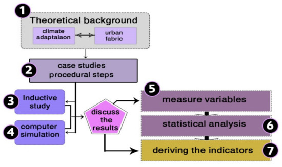
Figure 1.
Methodology steps.
3. Analysis of the Selected Case Studies
In this section, we discuss the procedures and steps that we followed to achieve the research objectives. We start by describing and defining the research case studies, inductive analysis of urban fabric elements and composition, and the computer simulation analysis. After this, we discuss the results of the computer analysis to determine the indicators of sustainability in the traditional urban fabric of West Asian cities; we then measure the relationship between indicators, determine the effectiveness of each indicator, and, finally, extrapolate and analyze the results.
3.1. Case Study Selection
The research was based on the deductive analysis method, through analyzing previous studies and research to determine the case study related to traditional natural climate adaptation. Four residential districts were selected from traditional cities, considering their climatic and spatial variation. The case study’s functional dimension was restricted to the old residential district, in order to achieve the research objectives. The spatial dimension was considered to include cities that are far apart, such as the east, west, north, and south of West Asia, and within hot–dry and semi-arid regions.
The case study areas were selected as follows:
- A residential district, old Yazd;
- A residential district, Al-Kadhimiya region, Baghdad;
- A residential district, Old Damascus; and
- A residential district, Sana’a old city.
The rationale for this choice lies in covering the various patterns of the urban fabric of traditional cities in West Asia, under the same natural conditions, and given the fact that the old districts in the four cities still retain most of the characteristics of the physical and traditional form. They have been continuously inhabited for several centuries, emphasizing the long-term fulfillment of people’s social requirements, even achieving the required adaptation, despite the climatic and social differences throughout this long period.
3.2. The Case Study Description
This section provides a detailed description and analysis of the selected areas.
3.2.1. The Center of Old Yazd
Yazd is a unique historical city located in the middle of the Iranian plateau, characterized by its unique architecture. It contains many wonders and historical buildings, narrow alleys, winding streets, unique houses, various mosques, and many public buildings and markets. It is also distinguished by unique architectural elements, such as wind towers, internal courtyards, domes and vaults, a diversity of urban and architectural components, and a unique urban fabric [33].
3.2.2. The Al-Kadhimiya Region, Baghdad City
The Al-Kadhimiya region was first formed on a religious basis. The city’s spatial organization was based on an important religious center of the Islamic world, such that the residential district was concentrated around it, forming an organic urban complex that resembles a circular shape. At the same time, the surrounding streets represented the borders of the area. The area is characterized, in general, by a compact organic urban fabric. The dwellings are close together, separated by narrow, twisted alleys shaded by the adjacent housing. Shanashel and its containment of open urban public space, together with the inner courtyard, forms an integrated environmental system.
3.2.3. Old Damascus
Damascus’s planning was influenced by Islamic architectural features, as it shifted from the grid style to the compact style. The housing units are distinguished by compactness, separated by only narrow, twisted alleys, which end at public urban spaces near the mosque. The alley is joined to the residence’s inner courtyard by a winding corridor from the main entrance to the house to the inner courtyard, where part of the ground floor is reserved for guests, allowing for privacy control and, at the same time, taking advantage of the beautiful views of the water fountain and trees as an internal facade in front of guests.
3.2.4. Sana’a Old City
A residential district in Sana’a old city features organic and compact planning, similar to the rest of the Islamic region cities, which are built around Islamic centers—the most important of which is the Great Mosque.
The houses in Sana’a are characterized by vertical buildings centered around a shared garden (orchard). Those houses that define tower houses are a result of development through the history of design, to take maximum advantage of the sunlight and natural ventilation. The tower houses are divided into six to nine floors. The utilization of natural energy entails excessive use of the southern facades, such that all living rooms and bedrooms on the south side contrast service rooms on the northern facades.
3.3. Inductive Analysis of Urban Fabric Elements and Composition
All Arab and Islamic cities in West Asia bear a close resemblance to each other, as they are characterized by narrow winding streets and a similar arrangement of buildings, such that a compact urban fabric is formed [34,35]. If we look at the planning of sections of the old cities in Damascus, Baghdad, Yazd, and Sana’a, as shown in Figure 2, Figure 3, Figure 4, Figure 5, Figure 6, we find that a plan can be taken from one city to another; this type of planning is due to the beginning of the movement towards urbanization.
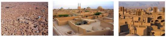
Figure 2.
Various shots show details and components of the urban fabric of the old Yazd [33].
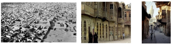
Figure 3.
Various shots show details and components of the urban fabric of Al-Kadhimiya district, old Baghdad [36,37].
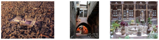
Figure 4.
Various shots show the urban fabric and open spaces of old Damascus [38].
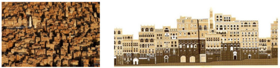
Figure 5.
Sky view of the urban fabric and urban facades in the city of old Sana’a [39].
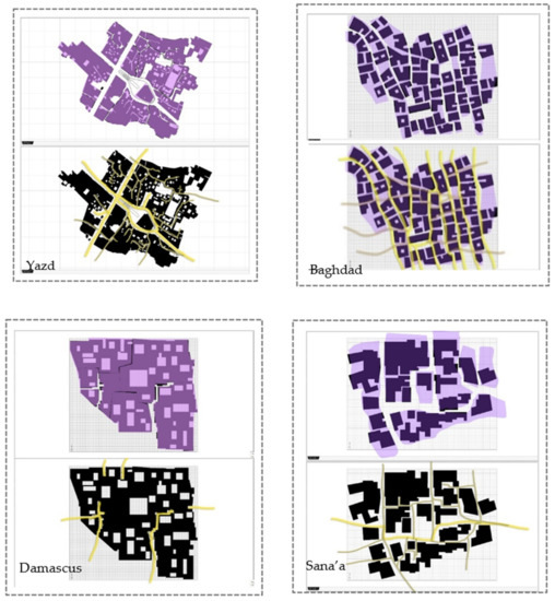
Figure 6.
Structural unity, components, shape, and layout of the traditional urban fabric for study cities in West Asia.
Although the arrangements of the buildings may seem random, there is a structural unity on which it is based: on a large-scale plan of the city, we can see that the social pattern is physically visible in terms of the locations of the different districts and public buildings, such as mosques and palaces; the areas are linked to each other in the market, and the streets devoted to various trades. The emergence of an ancient city shape in West Asia was not achieved through a single process but, instead, through continuous growth. However, planning problems were resolved upon their occurrence and through an accumulative process, until the final form was found as an original model [33].
3.3.1. Urban Design in Hot Climates in West Asian Cities
The overall planning of old cities was based fundamentally on the local climate features and protection strategies required to face their enemies during wars. As for hot–dry areas, the urban fabric is characterized by features that help it to reduce the impact of intense solar radiation, high temperatures, and various other harsh climatic conditions (e.g., dust storms), with different, highly compact components of the urban fabric [20,34]. The density of the urban fabric is a critical factor in the planning of residential neighborhoods in traditional cities of West Asia for climate response [34]. We also noticed similar characteristics in all traditional cities of West Asia, in that they contain vital components such as narrow winding alleys that infiltrate the contiguous blocks of houses and buildings, as well as contiguous and harmonious urban facades, which contain frequent shading elements. The gradation of urban squares and central courtyards inside buildings containing trees, water pools, fountains, thick walls, and building materials with high heat capacity was also observed [21]. Yazd, Kashan (Iran), Baghdad (Iraq), Damascus (Syria), Shebam Hadhramaut, Sana’a (Yemen), and others are formed from a very dense and compact organic urban fabric with narrow and irregular alleys. In Yazd, houses are contiguous with attention to orientation and have a functional distribution based on the direction of the sun and the movement of the winds. The general layout of the houses is characterized by a spatial gradation, with private inner courtyards surrounded by one- or two-story buildings. The local building materials are mud bricks, stones, and wood, depending on availability. Most of the ancient urban fabric of Yazd, Baghdad, Damascus, and Sana’a is similar to that of other desert cities in Western Asia.
The most distinctive and noticeable feature of traditional cities in West Asia is the relationship between blocks and voids. The dominance of the masses over urban fabric spaces and roads is remarkable. The solid-to-hollow ratio in house plans is also similar: 77:23% [34,38]. At the city scale, voids include public open spaces, roads, alleys, and central squares of homes. In general, the urban fabric of ancient cities in Western Asia is formed from significant components such as markets, mosques, palaces, squares, public baths, religious buildings, and courtyard houses [14,21,23,36].
3.3.2. Procedural Steps for Inductive Analysis of Urban Fabric Elements and Composition
Through inductive analysis, we attempted to find a set of indicators that can achieve the principles of sustainability, which were developed according to the literature review and through extrapolation of the components of case studies; studying the relationships between these components (Table 1) led to the fundamental sustainability indicators that are applied as an essential aspect of urban design. To affirm the goals of sustainable development represented by improving the sense of place, responding to the climate, interacting with nature, conserving energy and resources, and reducing waste in the natural environment, the street distribution and zoning should be improved, as it assists in the connection and integration of several societal components to reach urban sustainability [18,40,41]. Below is a list of the derived indicators that were studied and analyzed (Table 2).

Table 1.
Discussion and analysis of the achievement of climate adaptation strategies for the study cities, in terms of the requirements of climatic and social sustainability.
Table 2.
The proposed indicators, their relevance to sustainability, and the references upon which they were based.
From the results of the analysis and comparison provided in Table 1, we can summarize the most significant features of the urban fabric and the physical components of the study cities, and the extent to which they achieve the assumed sustainability indicators.
Urban form and urban fabric: The centralization of cultural, religious, and economic activities, the positioning of housing around these centers and axes in the form of contiguous and dense blocks, and the use of a free organic urban fabric to achieve this.
Analysis of physical components, dimensions, and volumes: These cities rely on two types of roads—public roads, which serve as hubs to reach public buildings and are surrounded by markets, and narrow, winding alleys within residential neighborhoods. The directions of the streets are twofold: in the less dense fabric, the streets are from east to west; in the dense fabric, the streets are slanted from south to north and winding.
Network of streets, axes, and directions: Public buildings, markets on the sides of streets, squares, edifices, alleys, corridors, monolithic blocks of housing, and internal courtyards are common. A relationship of gradation in dimensions and sizes, a trend from the particular to the general, and from the minor components to the major. It forms a homogeneous tissue with semi-spongy formations, due to the dense tissue interspersed with internal and external spaces scattered within it.
Land use and types of buildings: Types of uses include large public buildings, commercial buildings, mixed commercial and residential buildings on the first floor on the sides of the market streets, residential buildings, public squares, and sometimes small green farms (as in Sana′a old city). The uses are organized, in order to diversify and enhance the services according to the surrounding areas.
Open spaces and green areas: Due to the dense architectural fabric, the open spaces are generally small, but there is a proportion between the size of the squares and the types of traditional social activities. As for the green areas in Yazd, Baghdad, and Damascus, residential buildings contain inner squares, which are usually green spaces with trees; furthermore, the sides of the main streets also have trees, in order to provide shading. As for Sana′a, there are general urban green areas, called orchards, around which several residential buildings gather, and which have agricultural production that covers the city’s needs for some types of vegetables.
The shape of urban facades and sky line: A compact urban configuration with contiguous facades in harmony, which are rich in decorative elements, openings, and protrusions that serve as elements for shading and reducing the area of windows. The skyline expresses equality through the flatness and similarity of building heights, with the dominance of public and cultural buildings—in terms of height—as landmarks in the urban fabric.
3.4. Computer Simulation Analysis
Computer simulation is one of the best techniques by which it is possible to calculate the effects of climate factors on urban fabric and buildings [46,47,48]. The Ecotect software, which can accurately assess various designs and which depends on the Open studio engine, was selected. We tried to design the analysis for suitable simulation results, and identified analyses to study the impact of solar radiation on the urban fabric by simulating the solar radiation effect under various orientations and the effect on the urban spaces by solarization shading. Furthermore, we studied the influence of the formation of the urban configuration and building facades. The analyses that were used for the chosen cases were as follows: insolation analysis (total direct radiation, total daylight factor, total sunlight hours) and object attributes (avg. percentage shading, percent dissatisfaction).
3.4.1. Incident Solar Radiation and Total Radiation on Blocks
The results of the total radiation test on the area, in terms of the importance of the compact urban fabric in reducing the surfaces exposed to the hot solar rays, are shown in Figure 7 and Figure 8, with the daily average of solar insolation as follows: in Yazd, 4.5–5.5 kWh/m2 with 3200 sun hour/year; in Baghdad, 4.4–5 kWh/m2 with 3244 sun hour/year; in Damascus, 5.5–5.8 kWh/m2 with 3634 sun hour/year; and in Sana’a, 5–6 kWh/m2 with 3000 sun hour/year.
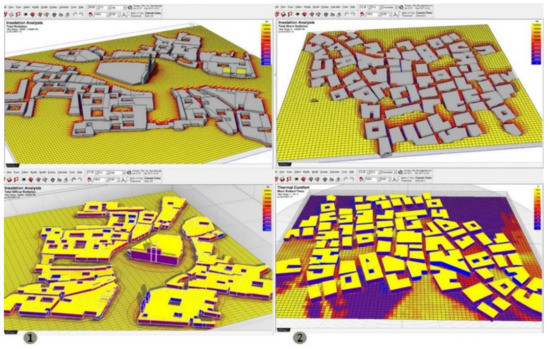
Figure 7.
Incident solar analysis of urban fabric in (1) old Yazd, (2) old Baghdad.
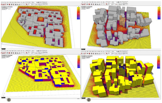
Figure 8.
Incident solar analysis of urban fabric in (1) old Damascus, (2) old Sana’a.
3.4.2. Shading Hours on Facades and Shading Levels on Streets and Urban Spaces
Analysis of the shading levels on urban spaces showed that the urban formation strategy of the traditional city’s urban fabric in West Asia featured shading considerations of high significance. As shown in Figure 9 and Figure 10, the shading ratio of the urban spaces in the Al-Kadhimiya district in Baghdad was the most significant, followed by Old Damascus, the old city of Sana’a, and, finally, the city of Yazd. As for the shading by the facades, especially the main facades, the shading percentage was semi-full in all of the studied cities, with a high shading rate during the hot summer season.
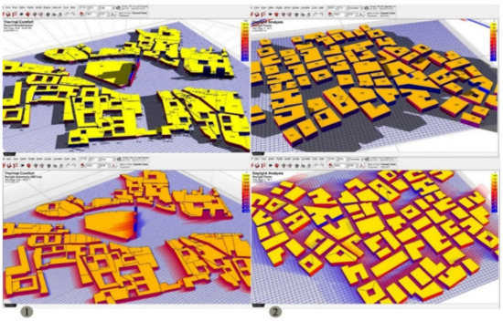
Figure 9.
Shading level analysis of urban fabric in (1) old Yazd, (2) old Baghdad.
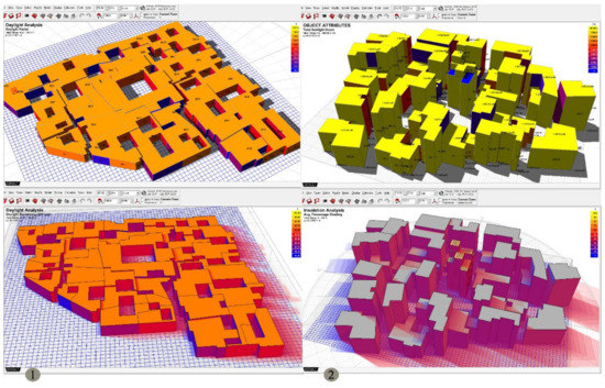
Figure 10.
Shading level analysis of urban fabric in (1) old Damascus, (2) old Sana’a.
3.5. Quantitative Analysis of the Effectiveness of Indicators
The research included several steps to arrive at the quantitative analysis. The first step was a literature review, from which the relationships between climate adaptation, the sustainability of cities, and the most critical factors for the sustainability of cities were extracted. The second step was to identify the study cases in four selected cities within the West Asia region, and then conduct an inductive analysis of them to arrive at the most critical indicators that lead to the achievement of a sustainable urban fabric. In the third step, a quantitative test was conducted on these four selected areas, classifying all the determinants that are associated with the sustainability indicators. This step was tested through a quantitative test list with a validation procedure. The fourth step was the quantitative analysis, where each indicator’s rate was determined, considering the study cases. Each indicator’s effectiveness was extracted separately, in order to determine each indicator’s importance, compared to all the study cases. Finally, the results were processed by unpacking the scan tests on panels and converting them into graphical form using the Excel software.
The quantitative analysis was based on survey tables to measure each indicator’s sub-indicators, and examine how each of the study cities achieved these indicators, as well as the effectiveness of each indicator. Indicators were coded as in Table 3, to facilitate the analysis.
Table 3.
Coding of sustainability indicators to facilitate their use in quantitative analysis strategies.
Indicator Relationship Measurement
The research relied on the inferential descriptive analysis method based on a set of variables, as shown in Figure 11. Moreover, through quantitative analysis, the relationships between the variables were measured, and Figure 12 shows the indicators after the coding process, noting that the indicators were only for the urban fabric.
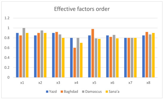
Figure 11.
Effective indictors’ ratio for the four case study cities.
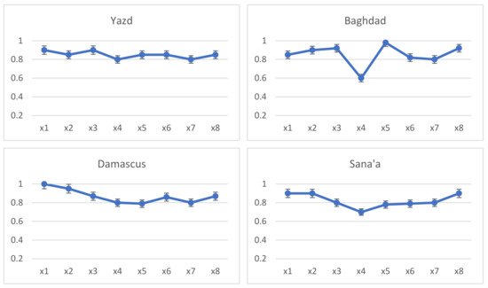
Figure 12.
Indictors’ values for the four case study cities.
The results show that all the extracted values were close to the assumed value of sustainability, which is equal to one. Figure 11 and Figure 12 show the variation in the importance of the effective indicators. As such, we could distinguish them in three ranges, according to their effectiveness values, where the first and second indicators occupied the first range; the eighth, third, and fifth indicators were in the second range; and the rest of the indicators were in the third range.
It was also concluded, from the quantitative analysis, as shown in Table 4 that the total values of the indicators for the study cities were very close. They all achieved the urban fabric sustainability indicators significantly, as Damascus city achieved 86%, Yazd achieved 85%, Baghdad achieved 84%, and Sana’a achieved 82%, as shown in Figure 12.
Table 4.
Comparison of indicator values for the four study cities and their percentages of effectiveness.
4. Discussion of Results
A significant portion of the presented work is concerned with developing the concept and methodology for traditional climate adaptation strategies, which is expected to pave the way for future in-depth and systematic research on comprehensive climate adaptation strategies in cities. According to the findings of this study, the four cities used as case studies all achieved a high percentage with the application of the assumed sustainability indicators. These indicators were generated to be proportional to the components and quality of life in traditional cities. The physical components and their relationship to the climate, as they developed determinants naturally before discovering modern energy resources, represent natural solutions and an honest and explicit reflection of human and environmental requirements. A detailed study of the indicators and the extent to which they are used in the study cities is provided in the following sections.
4.1. Discussion of the Results of Inductive Analysis of Urban Fabric Elements and Composition
In terms of the urban form and urban fabric, we observed that the strength of relations between activity areas and the required gradation from the private to public areas allowed for the achievement of privacy and safety through small residential neighborhoods with adjacent houses—an organic fabric that serves the climatic requirements in reducing solar radiation gain. However, the difficulty of perceiving paths by visitors, and a number of meandering and closed alleys impeding modern services, were observed, consistent with the findings of previous studies [14,16,33].
In the analysis of physical components, dimensions, and volumes, we found diverse uses of roads, differentiated between public and private to determine the type of users, gradation in the road structure, and reducing streets from north to south in order to avoid the effects of the prevailing north winds and dust storms. However, narrow streets impede the movement of modern vehicles and emergency movement. Closed, short, and winding alleys are difficult to move through for services and emergencies.
In terms of the network of streets, axes, and directions, we found that it achieved a balance between masses and visual comfort due to unity and gradation in the studied paths, achieving cultural meaning and climatic requirements. Dimensions and sizes confirm their importance, increasing in the direction of public spaces and decreasing in the direction of private spaces. However, there is difficulty in including modern components into the traditional composition; meanwhile, the presence of greater flexibility and accessibility in the paths will assist in the application of technology.
In terms of land use and the types of buildings, we found urban density with the economic exploitation of various land uses. Diversity of use serves to meet social and economic needs, and the distribution of services, public centers, and public squares achieves distributive justice. However, Damascus, Yazd, and Baghdad depended on internal outlets in the central courtyard of the dwelling buildings or outside the city as a public outlet for the community, there was a lack of spaces designated for children, and the markets assumed the most importance and space in the public streets.
In terms of open spaces and green areas, we found yards between private, mixed, and public areas, with their distribution and sizes according to the requirements of social and cultural activities. The proportion of green areas was reasonable, as well as the availability of shade and air movement required to generate good ventilation. However, there is a need to meet the modern requirements of public squares, due to a prosperous life and various outdoor activities, with a need to increase greening in public areas and streets to provide shaded areas and paths; this reinforces the findings of previous researchers [49], who have claimed that high ceilings and central courtyards can help to reduce direct sunlight penetration, thereby reducing heat stress in cities.
In terms of the shape of urban facades and the skyline, we observed morphological harmony in the skyline, with rhythm in elevations, thus achieving visual comfort, regularity, and equality. Many shading elements comprise the beautiful formation of the facades, thus achieving ventilation along with cultural and aesthetic shading.
4.2. Discussion of the Results of Computer Simulation
From the analysis results (as shown in Figure 7, Figure 8, Figure 9, Figure 10), the extent of the convergence of the urban fabric of the study cities from previous sustainability factors became clear. Although the four study cities showed variations in the results, they confirmed the application of climate adaptation principles in various proportions and forms. Moreover, they were consistent with the proposed sustainability indicators for the traditional urban fabric. The residential district in Yazd city applied most of the indicators that we considered, drawn from the urban fabric, using an extremely compact fabric to decrease or prevent the hot sun’s rays from accessing the streets and narrow alleys (Figure 7). The simulation results for Yazd city shown in Figure 8 indicated the use of an organic system with irregular, tight streets, with solid building facades to block approximately 80% of the solar radiation reaching the roads and alleys during the day, thus providing large shadow ranges for generating currents of cold air. It also houses mostly rectangular houses and vast facades toward the south and north, with narrow, winding alleys and shaded roads to keep the air more moderate inside the urban fabric and resistant to the impact of desert winds. Furthermore, horizontal expansion of the buildings and the variation in land uses according to the relationships and functions of buildings have led to the achievement of land use efficiency.
The residential district in Al-Kadhimiya was identified as an area generally having an organic, traditional, compact fabric, arising from disjoined houses separated by some narrow alleys. Various overhangs shade them by facades and the neighboring buildings, containing a public urban courtyard with a fully integrated inner courtyard environmental system (Figure 7 and Figure 9). Based on the computer simulation of Al-Kadhimiya, the compact traditional urban plan prevents solar radiation from reaching the urban spaces by approximately 65%, providing shading spaces to generate cooling air currents, and the urban spaces between the masses were aligned to the north, in order to be maximally shaded throughout the day. Total incident radiation analysis confirmed the success of the traditional planners in producing most roads and narrow alleys from south to north, as it achieved a reduction in the area of building facades.
The residential district in the old city of Damascus was designed in consideration of planning in line with Islamic thought, changing from a grid style to the distinctive compact style, characterized by compressed residential units separated by some narrow, winding alleys. These alleys terminate towards public courtyards. Furthermore, the alleys are connected to the central courtyards of the houses, across the winding corridors in the house entrances. As only the ground floor is assigned to the public, enough privacy could be obtained (Figure 8). The results of the computer simulation indicate, as shown in Figure 10, that over 90% of the solar radiation reaching the street, alleys, and public spaces is blocked, as an extraordinary feature of the urban fabric and all houses is that the facades provide shade throughout the whole day. Moreover, trees and water bowls are used inside the courtyard to decrease the influence of solar radiation and create cooling air currents.
Finally, we considered the residential district in Old Sana’a. Although the cities of the mountainous regions in Yemen are distinguished by tower houses, which differ from the horizontal housing patterns in the rest of the hot–dry climate regions in West Asia, the solutions and characteristics achieved the same performance. The vertical houses are typically compiled around shared gardens (orchards). The houses that define tower houses are a result of design evolution, benefitting from natural ventilation and sunlight, with tower houses having six to eight levels. The utilization of natural energies and efficient use of the southern facades are considered; as such, the bedrooms are located on the south side of buildings. In contrast, service rooms are located on the north side. As shown in Figure 8, the computer simulation results showed that various urban squares and alleys identified the urban planning and streets of the old City of Sana’a, having gradual sizes and trends to form shading and solarization zones, thus creating cooling air currents (see Figure 10). Furthermore, the results verified that the orientation had very high importance and was given special attention, indicating the effect of shadows on the buildings, as well as for streets and public squares, providing the required solarization in winter and shading in summer, with a more significant effect on south facades.
4.3. Discussion of Quantitative Analysis
The quantitative analysis provided us with a detailed view of the priority of each indicator, according to the local climatic conditions. As the results show in Table 4 we noticed a slight difference in the values of the indicators for the different study cities, where the urban compactness indicator achieved top priority in all of the study cities.
The results confirmed the effectiveness of employing traditional climate adaptation systems, measuring its effectiveness and feasibility through indicators of urban fabric sustainability. Our results defined sustainability indicators and measured their effectiveness, serving as an extension of the elegant work of researchers [12,36,50], who explained the principles of sustainability and studied the characteristics of sustainability in buildings. Furthermore, we utilized the findings of previous researchers [51], who confirmed that all urban characteristics play a role in shaping the urban heat pattern at the same time. Our research was distinguished by identifying indicators that can be applied as design determinants. We found that the sustainability indicators suggested in this article, as well as knowing their effectiveness and the relationships between them, can allow designers and planners to follow a more efficient and detailed methodological approach that achieves sustainability strategies within the local scale, according to climate adaptation in hot, dry areas, and also contributes to learning from the old to create the new.
5. Indicators of the Sustainable Climate-Adaptive Urban Fabric of Traditional Cities in West Asia
Our results confirmed the achievement of the selected indicators for the sustainability of the urban fabric. The quantitative analysis also demonstrated the effectiveness of each indicator for different cities to reach sustainability at the level of the urban fabric. We verified that the traditional architecture has an honest representation of its environment, being capable of dealing with climatic conditions and social requirements, and which directs the emergence of a natural style for a new personality that fits those environmental conditions and includes several indicators based on adaptation strategies. In this study, we do not advocate for old standards or a return to the past but, rather, examine how these innate techniques were born, grew, and developed over many years of accumulated experiences, in order to deal with the local climate by the peoples of the region, based on the innate and natural determinants that achieve harmony between architecture and the environment. As a result, climate adaptation can be achieved and the effects of unbridled climate change can be mitigated.
We discovered that these indicators can help to achieve a sustainable urban fabric strategy for hot–dry regions, where integration and harmony with the natural environment and climate can be reached, thus improving resource utilization and reducing energy consumption. We summarize the most important indicators of sustainability based on climate adaptation as follows:
- Highly compressed urban fabric—Urban planning is an essential tool to control the climate; as such, a compact urban fabric decreases the surface/volume of masses exposed to harsh climatic conditions, as well as minimizing the open public spaces. Similarly, the width and direction of roads are affected, facades act as shading elements, and buildings may shade each other.
- Control of solar radiation exposure by orientation—Reducing the surface of southern facades with shading, minimizing openings, domes, and vault roofs, and distributing spatial functions according to the orientation are important. Moreover, the orientation of urban public spaces and building courtyards to the south or southwest protects exposed sides from the sun through Mashrabyahs and shading elements.
- The principle of streamlining spaces creates pressure differentials, whereby air movement currents temper the microclimate in the urban fabric, which begins from urban public spaces through alleys and ends in inner courtyards. Furthermore, the humanization of pathways and the hierarchy of urban spaces allow for smooth movement while achieving protection and privacy.
- Insertion of nature inside the urban formation (green areas)—One of the standard features of traditional urban fabric is many open spaces (open urban areas beside private courtyards), which includes elements of water, trees, and plants. Simultaneously, it serves to decrease the UHI by reducing the urban surface.
- Land use efficiency—Achieving land use efficiency by stacking in building blocks to minimize streets and create open urban spaces in small areas, distributed as nodes between one residential cluster and another.
- Integration with the ecosystem—Adopting sensitive bioclimatic planning of energy, and using the standards at necessary levels, regarding comfort in public and private open spaces, further enhancing their efficiency due to using ecological construction materials, as well as achieving social demands, indicating a model of integration between humans and the ecosystem.
- Walking movement should be separated from traffic movement—Designing streets inside residential complex blocks for the movement of people, while vehicle movement is conducted by large movement axes through the main streets outside the residential blocks.
- Urban facade formations—The compressed urban composition leads to compact facades, featuring morphologic harmony and being rich in shading elements and Mashrabyahs with reduced window area.
6. Conclusions
We explored effective sustainability indicators for the urban fabric in hot–dry areas, allowing for a detailed explanation of and findings supporting the effectiveness of adopting climate adaptation strategies, in terms of planning and individual building design. Sustainability strategies emphasize thinking at the local scale and conservation of natural resources, reducing energy-depleting consumption, and learning from the traditional to create new; this is the vocabulary of the most critical sustainable architecture considerations, in order to create a new architecture that respects the specifics of the place, and fits with the determinants of the surrounding environment. The principles of sustainability drawn from the studied traditional architectural applications have a dynamic role, due to their integrated relationship with the physical environment; however, it is also derived with respect to fulfilling the requirements of the inhabitants. Traditional planning and architecture remain a direct answer to the climatic impacts arising from the physical surroundings. Highly arid environments impose severe constraints on design ambitions, in which case good design practices alone cannot guarantee acceptable year-round conditions. Active systems, such as mechanical cooling air systems and water features, consume energy and water, and should be used with caution and placed where the maximum impact can be achieved in major arid cities. It should be noted that there are also intermediate design options between purely traditional measures, such as solar shading and purely active measures. For example, there may be a possibility to create semi-conditioned spaces for exterior design. Alternatively, public spaces can utilize the space within some buildings to mutually benefit from air conditioning across the space. This approach can provide valuable areas of rest within the public realm within hot arid cities that positively use existing cooling systems. The more significant findings of this research include many indicators that can be improved to adapt to the local climate, including the compact urban fabric, the principle of streamlining space, integration into the local ecosystem, and land use efficiency, thus integrating nature into the urban composition. These indicators represent an approach for sustainable urban fabric planning. It achieves integration and harmony between the elements of the urban environment, nature, and climate parameters, leading to the optimal utilization of natural energies and reductions in the consumption of resources and energy. Finally, from a critical point of view, the results of this article serve as a baseline for more comprehensive research that considers future requirements and benefits from technology.
Author Contributions
Conceptualization, A.A.N.A.; methodology, A.A.N.A. and Y.W.; software, A.A.N.A.; validation, A.F.K. and R.H.; formal analysis, A.A.N.A.; investigation, A.A.N.A. and A.F.K.; resources, K.M.A.; data curation, A.A.N.A.; writing—original draft preparation, A.A.N.A. and K.M.A.; writing—review and editing, A.A.N.A. and A.F.K.; supervision, Y.W.; funding acquisition, Y.W. All authors have read and agreed to the published version of the manuscript.
Funding
This research was funded by the National Natural Science Foundation of China, grant number 51778559 (2018/01–2021/12).
Institutional Review Board Statement
Not applicable.
Informed Consent Statement
Not applicable.
Data Availability Statement
The data presented in this research article are available from the corresponding author (Y.W.) on request.
Conflicts of Interest
All authors confirm that there are no conflicts of interest regarding this manuscript.
References
- Almusaed, A.; Almssad, A.; Homod, R.Z.; Yitmen, I. Environmental profile on building material passports for hot climates. Sustainability 2020, 12, 3720. [Google Scholar] [CrossRef]
- Meir, I.A.; Roaf, S.C. Thermal Comfort—Thermal Mass: Housing in Hot Dry Climates. Architecture. Indoor Air 2002, 9, 1050–1055. [Google Scholar]
- Naïma, F.; Mébirika, B.; Belkacem, D.; Claude-Alain, R. The Traditional House with Horizontal Opening: A Trend towards Zero-energy House in the Hot, Dry Climates. Energy Proc. 2016, 96, 934–944. [Google Scholar] [CrossRef]
- Li, D.H.W.; Yang, L.; Lam, J.C. Impact of climate change on energy use in the built environment in different climate zones—A review. Energy 2012, 42, 103–112. [Google Scholar] [CrossRef]
- Hayes, P.; Dobias, R. Climate Change in Central and West Asia; Asian Development Bank: Mandaluyong, Philippines, 2010. [Google Scholar]
- UNFCCC. Climate Change: Impacts, Vulnerabilities and Adaptation in Developing Countries; United Nations Framework Convention on Climate Change; United Nations: New York, NY, USA, 2007; pp. 1–68. [Google Scholar] [CrossRef]
- Dubois, C.; Cloutier, G.; Rynning, M.K.R.; Adolphe, L.; Bonhomme, M. City and building designers, and climate adaptation. Buildings 2016, 6, 28. [Google Scholar] [CrossRef]
- Wan, K.K.W.; Li, D.H.W.; Pan, W.; Lam, J.C. Impact of climate change on building energy use in different climate zones and mitigation and adaptation implications. Appl. Energy 2012, 97, 274–282. [Google Scholar] [CrossRef]
- Masnavi, M.R. Measuring Urban Sustainability: Developing a Conceptual Framework for Bridging the Gap Between theoretical Levels and the Operational Levels. Int. J. Environ. Res. 2007, 1, 188–197. [Google Scholar]
- Sodiq, A.; Baloch, A.A.B.; Khan, S.A.; Sezer, N.; Mahmoud, S.; Jama, M.; Abdelaal, A. Towards modern sustainable cities: Review of sustainability principles and trends. J. Clean. Prod. 2019, 227, 972–1001. [Google Scholar] [CrossRef]
- Natanian, J.; Auer, T. Beyond nearly zero energy urban design: A holistic microclimatic energy and environmental quality evaluation workflow. Sustain. Cities Soc. 2020, 56, 102094. [Google Scholar] [CrossRef]
- Xie, X.; Zheng, Y. Research on the Evaluation Indicator System for Climate Adaptive Cities: A Case Study of Beijing. Chin. J. Urban Environ. Stud. 2017, 5, 1750007. [Google Scholar] [CrossRef]
- Yulandhika, T.; Nugrahanti, I.M. Mitigation and Adaptation Planning of Climate Change in East Kalimantan: A Critical Review. Procedia Soc. Behav. Sci. 2014, 135, 64–69. [Google Scholar] [CrossRef]
- Moradi, A.M.; Akhtarkavan, M. Sustainable Architecture in The Hot, Arid and Sunny Regions of Iran. IUST International. J. Eng. Sci. 2008, 19, 21–29. [Google Scholar]
- Alabsi, A.A.N.; Song, D.X.; Garfield, W.H. Sustainable Adaptation Climate of Traditional Buildings Technologies in the Hot Dry Regions. Proc. Eng. 2016, 169, 150–157. [Google Scholar] [CrossRef]
- Nabavi, S.O.; Haimberger, L.; Samimi, C. Climatology of dust distribution over West Asia from homogenized remote sensing data. Aeolian Res. 2016, 21, 93–107. [Google Scholar] [CrossRef]
- Barlow, M.; Zaitchik, B.; Paz, S.; Black, E.; Evans, J.; Hoell, A. A review of drought in the Middle East and southwest Asia. J. Clim. 2016, 29, 8547–8574. [Google Scholar] [CrossRef]
- Shahin, B.; Abdullah, S. The traditional solutions in the sustainable climatic adaptation and its employment in the contemporary housing. Baghdad Univ. Eng. J. 2009, 15, 584–604. [Google Scholar]
- Huseynov, E.F.O. Planning of sustainable cities in view of green architecture. Proc. Eng. 2011, 21, 534–542. [Google Scholar] [CrossRef]
- Kamal, M.A. The morphology of traditional architecture of Jeddah: Climatic design and environmental sustainability. Glob. Built Environ. Rev. 2014, 9, 4–26. [Google Scholar]
- Jamalinezhad, M.; Talakesh, S.M.; Soltani, S.H.K. Islamic Principles and Culture Applied to Improve Life Quality in Islamic Cities. Proc. Soc. Behav. Sci. 2012, 35, 330–334. [Google Scholar] [CrossRef]
- John, G.; Clements-Croome, D.; Jeronimidis, G. Sustainable building solutions: A review of lessons from the natural world. Build. Environ. 2005, 40, 319–328. [Google Scholar] [CrossRef]
- Ajaj, A.; Pugnaloni, F. Re-Thinking Traditional Arab Architecture: A Traditional Approach to Contemporary Living. Int. J. Eng. Technol. 2014, 6, 286–289. [Google Scholar] [CrossRef]
- Bayaty, N.M.H.; Aldewach, H.D. Directionality of the Traditional Urban Fabric—Mosul as a case study. In Proceedings of the 1st International Conference on Architecture and Interior Design Applications, Erbil, Iraq, 7–8 February 2018. [Google Scholar]
- Alabsi, A.A.N.; Dexuan, S.; Liu, Z. Traditional solutions in climate adaptation and low energy buildings of hot-arid regions in west Asia. In Proceedings of the 12th International Conference on Green and Energy-Efficient Building; Beijing, China, 30–31 March 2016, Alabsi, A.A.N., Ed.; Urban Development Studies: Beijing, China; pp. 1–7.
- Khalili, M.; Amindeldar, S. Traditional solutions in low energy buildings of hot-arid regions of Iran. Sustain. Cities Soc. 2014, 13, 171–181. [Google Scholar] [CrossRef]
- Fraser, E.D.G.; Dougill, A.J.; Mabee, W.E.; Reed, M.; McAlpine, P. Bottom up and top down: Analysis of participatory processes for sustainability indicator identification as a pathway to community empowerment and sustainable environmental management. J. Environ. Manag. 2006, 78, 114–127. [Google Scholar] [CrossRef] [PubMed]
- Hiremath, R.B.; Balachandra, P.; Kumar, B.; Bansode, S.S.; Murali, J. Indicator-based urban sustainability—A review. Energy Sustain. Dev. 2013, 17, 555–563. [Google Scholar] [CrossRef]
- Ravetz, J. Integrated assessment for sustainability appraisal in cities and regions. Environ. Impact Assess. Rev. 2000, 20, 31–64. [Google Scholar] [CrossRef]
- Martilli, A.; Krayenhoff, E.S.; Nazarian, N. Is the Urban Heat Island intensity relevant for heat mitigation studies? Urban Clim. 2020, 31, 100541. [Google Scholar] [CrossRef]
- Chu, E.K.; Mahendra, A.; Chu, E.; Brown, A.; Michael, K.; Du, J.; Lwasa, S. Unlocking the Potential for Transformative Climate Adaptation in Cities; World Resources Institute: Washington, DC, USA, 2019. [Google Scholar] [CrossRef]
- Voskamp, I.M.; de Luca, C.; Polo-Ballinas, M.B.; Hulsman, H.; Brolsma, R. Nature-based solutions tools for planning urban climate adaptation: State of the art. Sustainability 2021, 13, 6381. [Google Scholar] [CrossRef]
- Rad, M.A. Creating a Future for an Ancient Sustainable City, Yazd. 2014. Available online: http://hdl.handle.net/10012/8784 (accessed on 11 September 2014).
- Dheyaa Al-Shouk, N.; Shamkhi Al-Khfaji, A. Toward Sustainable Compact City: (Study in Convert Traditional Najaf City to Sustainable Compact City). KnE Eng. 2018, 3, 167. [Google Scholar] [CrossRef]
- Sarhan, A.E.; Farghaly, Y.; Mamdouh, A. The influence of urban fabric typologies on pedestrian wayfinding. J. Al-Azhar Univ. Eng. Sect. 2021, 16, 49–62. [Google Scholar] [CrossRef]
- Golubeva, Y. Evolutionary approach towards redevelopment of historical sites versus complete erasure. Case study Kadhimiya historical centre, Baghdad, Iraq. In Proceedings of the 47th ISOCARP Congress, Wuhan, China, 24–28 October 2011. [Google Scholar]
- Al-Saaidy, H.J.E. Lessons from Baghdad City Conformation and Essence. In Sustainability in Urban Planning and Design; IntechOpen: London, UK, 2020; pp. 1–31. [Google Scholar]
- Othman, H.S.M. Architectural techniques in traditional Architectureand how to use them to reduce energy consumption in buildings. In Proceedings of the International Conference: Cities’ Identity Through Architecture and Arts (CITAA), Cairo, Egypt, 11–13 May 2017. [Google Scholar]
- Al-Taher Engineering Consulting Center. Sana’a, the Foundations of Architectural Design and Urban Planning in Different Islamic Eras; Islamic Capitals and Cities Organization: Jeddah, Saudi Arabia, 2005. (In Arabic) [Google Scholar]
- Mohareb, N.I. Land use as a sustainability indicator for Arab cities. Proc. Inst. Civ. Eng. Urban Des. Plan. 2010, 163, 105–116. [Google Scholar] [CrossRef]
- Al-Saffar, M. Baghdad the City of Cultural Heritage and Monumental Islamic Architecture. Disegnarecon 2020, 13, 141–145. [Google Scholar] [CrossRef]
- Chatzipoulka, C.; Steemers, K.; Nikolopoulou, M. Density and coverage values as indicators of thermal diversity in open spaces: Comparative analysis of London and Paris based on sun and wind shadow maps. Cities 2020, 100, 102645. [Google Scholar] [CrossRef]
- Abraar, M.; Nicosia, I. Sustainability in Hot Arid Climate. Master’s Thesis, University of Nicosia, Nicosia, Cyprus, May 2018. [Google Scholar]
- Boyko, C.T.; Gaterell, M.R.; Barber, A.R.G.; Brown, J.; Bryson, J.R.; Butler, D.; Caputo, S.; Caserio, M.; Coles, R.; Cooper, R.; et al. Benchmarking sustainability in cities: The role of indicators and future scenarios. Glob. Environ. Change 2012, 22, 245–254. [Google Scholar] [CrossRef]
- Aflaki, A.; Mirnezhad, M.; Ghaffarianhoseini, A.; Ghaffarianhoseini, A.; Omrany, H.; Wang, Z.H.; Akbari, H. Urban heat island mitigation strategies: A state-of-the-art review on Kuala Lumpur, Singapore and Hong Kong. Cities 2017, 62, 131–145. [Google Scholar] [CrossRef]
- Al-Tamimi, N.; Qahtan, A.; Abuelzein, O. Rear zone for energy efficiency in large mosques in Saudi Arabia. Energy Build. 2020, 223, 110148. [Google Scholar] [CrossRef]
- Reinhart, C.F.; Dogan, T.; Jakubiec, A.; Rakha, T.; Sang, A. UMI-AN Urban simulation enveronment for building energy use, daylighting and walkability. In Proceedings of the 13th Conference of International Building Performance Simulation Association (BS2013), Chambéry, France, 26–28 August 2013; pp. 476–483. [Google Scholar]
- Salvati, A.; Palme, M.; Chiesa, G.; Kolokotroni, M. Built form, urban climate and building energy modelling: Case-studies in Rome and Antofagasta. J. Build. Perform. Simul. 2020, 13, 209–225. [Google Scholar] [CrossRef]
- Alavipanah, S.; Haase, D.; Makki, M.; Nizamani, M.M.; Qureshi, S. On the spatial patterns of urban thermal conditions using indoor and outdoor temperatures. Remote Sens. 2021, 13, 640. [Google Scholar] [CrossRef]
- Kalvelage, K.; Passe, U.; Rabideau, S.; Takle, E.S. Changing climate: The effects on energy demand and human comfort. Energy Build. 2014, 76, 373–380. [Google Scholar] [CrossRef]
- Alavipanah, S.; Schreyer, J.; Haase, D.; Lakes, T.; Qureshi, S. The effect of multi-dimensional indicators on urban thermal conditions. J. Clean. Prod. 2018, 177, 115–123. [Google Scholar] [CrossRef]


Publisher’s Note: MDPI stays neutral with regard to jurisdictional claims in published maps and institutional affiliations. |
© 2021 by the authors. Licensee MDPI, Basel, Switzerland. This article is an open access article distributed under the terms and conditions of the Creative Commons Attribution (CC BY) license (https://creativecommons.org/licenses/by/4.0/).