Article

Infrastructure BIM Platform for Lifecycle Management

1
Department of Architectural Engineering, Sejong University, Seoul 05006, Korea
2
Universal Design & Novel Solution (UDNS) Co., Ltd., Yongin 16976, Korea
3
Korea Institute of Civil Engineering and Building Technology (KICT), Goyang 10223, Korea
*
Authors to whom correspondence should be addressed.
These authors contributed equally to this work as corresponding author.
Appl. Sci. 2021, 11(21), 10310; https://doi.org/10.3390/app112110310
Submission received: 30 September 2021 / Revised: 23 October 2021 / Accepted: 29 October 2021 / Published: 3 November 2021

Abstract

:
Recently, the application of the BIM technique to infrastructure lifecycle management has increased rapidly to improve the efficiency of infrastructure management systems. Research on the lifecycle management of infrastructure, from planning and design to construction and management, has been carried out. Therefore, a systematic review of the literature on recent research is performed to analyze the current state of the BIM technique. State-of-the-art techniques for infrastructure lifecycle management, such as unmanned robots, sensors and processing techniques, artificial intelligence, etc., are also reviewed. An infrastructure BIM platform framework composed of BIM and state-of-the-art techniques is then proposed. The proposed platform is a web-based platform that contains quantity, schedule (4D), and cost (5D) construction management, and the monitoring systems enable collaboration with stakeholders in a Common Data Environment (CDE). The lifecycle management methodology, after infrastructure construction, is then completed and is developed using state-of-the-art techniques using unmanned robots, scan-to-BIM, and deep learning networks, etc. It is confirmed that collaboration with stakeholders in the CDE in construction management is possible using an infrastructure BIM platform. Moreover, lifecycle management of infrastructure is possible by systematic management, such as time history analysis, damage growth prediction, decision of repair and demolition, etc., using a regular inspection database based on an infrastructure BIM platform.

1. Introduction

The safety and stability of infrastructure is an important factor in the economic and social development of a country. Over the last few decades, the demand for improved technologies for the efficient and cost-effective management of aging infrastructure has increased due to the inefficiency and resource waste of traditional infrastructure management systems [1]. Building Information Modeling (BIM) technology has been accepted as one of the best tools for the enhancement of management systems in Architecture, Engineering, Construction, Owner, and Operator (AECOO) industries [2]. Recently, research for introducing BIM into the infrastructure industry, such as for roads, bridges, tunnels, etc., as well as the building industry, has been carried out [1,2,3]. BIM has the advantage of the lifecycle management of infrastructure, from planning and design to construction and maintenance [4,5]. The introduction of BIM at the planning stage will systematically enhance project management and collaboration between stakeholders [6]. BIM also helps, not only collaboration in the design stage, but also design quality enhancing and error reduction, etc. [7]. In the construction stage, BIM can increase productivity and workflow by reducing the wastage of time and resources [8]. Moreover, stored BIM data on infrastructure during the planning and design stage can be used afterwards for maintenance. Effective maintenance of infrastructure is possible through the integration of BIM with state-of-the-art technologies, such as unmanned robots and Unmanned Aerial Vehicle (UAV) systems with digital cameras or 3D Laser Scanning and Light Detection and Ranging (LiDAR), 3D model construction algorithms, and artificial intelligence algorithms, etc. [9,10,11].
Globally, the BIM market will expand to USD 15.06 billion by 2027. Many countries, such as the USA, Canada, Germany, the UK, China, Japan, India, South Korea, and Singapore, have adopted and developed BIM [12]. In South Korea, the Ministry of Land, Infrastructure, and Transport (MOLIT) announced in December 2020, the “introduction of full-scale BIM in the construction industry” for the full-scale introduction of BIM into infrastructure projects [13]. The “Basic Guidelines for Construction Industry BIM” and “BIM activation roadmap for 2030” were then prepared for the lifecycle management of infrastructure by sharing information from the planning, design, construction, and maintenance stages of the construction industry with every stakeholder to maximize productivity [14]. In addition, in the “Basic Guidelines for Construction Industry BIM” (published in 2020), the procedures for applying BIM to construction, major standards defined by BIM, and a Common Data Environment (CDE) were established. Therefore, international standard formats, such as Industry Foundation Classes (IFC) and Extensible Markup Language (XML) are recommended to manage infrastructure in the CDE, because infrastructure management projects involving various stakeholders using different software programs such as Autodesk BIM 360, Trimble Connect, Bentley, etc. are usually difficult to consolidate [15,16,17].
Therefore, in this article, a systematic analysis of the current state of BIM and state-of-the-art techniques for infrastructure management is performed. A BIM platform-based lifecycle management method is then proposed. The objectives and novelties of this study are as follows: (1) A literature review of BIM and state-of-the-art techniques for the lifecycle management of infrastructure is performed, (2) a lifecycle management method combining state-of-the-art techniques is proposed, and (3) the proposed infrastructure BIM platform is validated using a simple scenario. It is confirmed that collaboration with stakeholders in the CDE in construction management is possible using an infrastructure BIM platform. Moreover, lifecycle management of infrastructure is possible by systematic management, such as time history analysis, damage growth prediction, decision of repair and demolition, etc., using a regular inspection database based on an infrastructure BIM platform. This article is organized as follows. The research methodology to clarify the target literature is introduced in Section 2. Section 3 presents analysis of the literature and discusses the research conducted by some researchers. Section 4 explains the development of an infrastructure BIM platform. Finally, Section 5 concludes the article.

2. Research Methodology

For the systematic review, the following four steps were carried out: (1) categorizing of keywords and topics; (2) collection of relevant articles from Web of Science; (3) applying filters; and (4) full text analysis and detail categorization of articles based on main purpose.

2.1. Categorizing Keywords and Topics

Topics were divided into infrastructure, BIM, robots and sensors, and Artificial Intelligence (AI) and Structural Health Monitoring (SHM). Keywords for each topic were decided using a review of the literature [18,19,20]. Representative keywords for each topic were: “building information modeling”, “bridge”, “road”, “robot”, “UAV”, “scan-to-BIM”, “deep learning”, “damage detection”, etc. A detailed list of keywords is shown in Table 1.

2.2. Collection of Relevant Articles from Web of Science

Literature was collected using three categories, combining infrastructure and three main topics: (1) infrastructure and BIM; (2) infrastructure and robot and sensor; and (3) infrastructure and AI and SHM. The main topics were then renamed as “BIM for infrastructure lifecycle management”, “state-of-the-art techniques for infrastructure 3D model construction”, and “deep learning for automated damage evaluation of infrastructure”. The total number of articles found was 3432, as shown in Figure 1.

2.3. Filter Applying

The collected literature was firstly reduced by automatic filtering rules: (1) duplicated articles were removed; (2) English journal articles during the past ten years (2011 to 2021) remained. Non-related articles were then roughly and manually reduced by checking the titles and abstracts. The total number of articles was reduced to 1000.

2.4. Full Text Analysis and Detail Categorization of Articles Based on Main Purpose

Next, a full text review was performed to remove similar works. Only 40 works in the literature were selected. The BIM category was then subdivided into planning and design, construction, and management. The robot and sensor category was also subdivided into unmanned robot, sensors, and algorithms.

3. Literature Reviews of Infrastructure Lifecycle Management

3.1. BIM for Infrastructure Lifecycle Management

Although infrastructure has many stages during its lifecycle, the gathered literature was analyzed by dividing it into three categories: planning and design, construction, and management.
In the planning stage, BIM aids in the effective and fast determination of the best solution among a number of scenarios [8]. Application of BIM from the beginning of large-scale projects makes communication simple while enhancing collaboration among different stakeholders. BIM is also applicable to reduce design errors, enhance quality, check quality and clash, etc., in the design stage. Haussler and Borrmann proposed fourteen kinds of quality parameters to establish a standardized means of validating design quality [21]. Park et al. proposed an extended IFC schema, which is still not able to be completed for steel box bridges, and they developed an IFC-based steel bridge information model in the design phase [22]. Borrmann et al. developed an IFC-based multi-scale BIM shield tunnel model with a methodology of transformation using a multi-scale model in CityGML [23]. Nath et al. proposed a BIM-based reinforced workflow of precast shop drawing generation [24]. Girardet and Boton developed a parametric file that designs and generates any type of bridge to solve difficult applications of the BIM schema to bridges [25].
A well-developed BIM model in the planning and design stage is helpful, not only for reducing construction errors, missing and clash, but also for enhancing construction quality and processes in the construction stage. Shin et al. validated the advantages of adapting BIM at a railway construction site using seven construction projects [26]. Lee et al. developed a bridge BIM model to combine the design and construction processes of a precast box-girder bridge [27]. Liu et al. developed 4D GeoBIM, which combined BIM and geographical information systems (GIS) to ensure construction efficiency and safety [28]. Koch et al. proposed a tunnel information modeling framework for safe tunnel construction [29]. Time and cost resource management of the construction stage is also important. Therefore, the schedule (4D) and cost (5D) BIM was proposed and developed. Marzouk and Hisham’s BIM was based on a time and cost management technique of bridges by integrating BIM with the earned value (EV) concept to determine the status of a project at a specific reporting date [30]. Mawlana et al. proposed 4D BIM to sequentially construct and reconstruct highways to prevent the probability of potential stochastic spatiotemporal clashes [31]. Ding et al. developed a multidimensional (nD) modeling technique, integrating a work breakdown structure (WBS) and other construction code structures for rail transit construction [32].
After construction, infrastructure needs regular monitoring to remain functional and safe. In the USA, the National Bridge Inspection Standards (BNIS) require inspection at least once every 24 months for highway bridges. In South Korea, infrastructure has been regularly managed by the Special Act on the Safety Control and Maintenance of Establishments law since 1995. Structural Health Monitoring (SHM) of infrastructure is the main concern for lifecycle management. Valdepenas et al. developed a BIM for port maintenance [33]. Lee et al. developed a framework BIM-3D GIS system for effective maintenance of utility tunnels [34]. Sharafat et al. developed a BIM-GIS framework for underground utility management systems [35]. Boddupalli et al. proposed an SHM-BIM digital platform for automated health monitoring of infrastructure [36]. Kaewunruen et al. proposed 6D BIM for time schedule management, cost estimation, and carbon footprint analysis across the lifecycle of bridges [37].

3.2. State-of-the-Art Techniques for 3D Model Construction of Infrastructure

Inspection of large infrastructure, including inaccessible areas, by experts is sometimes difficult and dangerous. Therefore, there are a number of trials in which to apply sensors, such as digital cameras, LiDAR, etc., using unmanned robots and UAVs. Kim et al. developed a UAV system for health monitoring of concrete bridges [38]. Jiang and Zhang developed a wall-climbing UAV to inspect surface cracks of a concrete bridge [39]. Ribeiro et al. proposed an SHM for high-rise telecommunication towers using UAVs [40]. Jang et al. developed a multiple-digital-cameras-mounted ring-type climbing robot system for crack evaluation of a concrete bridge pier [9].
The gathered data from sensors embedded on unmanned robots are used to build 3D models. LiDAR is widely used to establish an as-built infrastructure in the digital domain as a 3D model. Digital images are also used to establish 3D models using a photogrammetry algorithm [41,42]. Three-dimensional point cloud data are used to generate BIM models [43,44].

3.3. Deep Learning for Automated Damage Evaluation of Infrastructure

To detect damage to infrastructure early, the technique of expert-dependent visual inspection has been widely accepted over the last few decades. However, visual inspection by experts is unsafe, time-consuming, and unreliable. To overcome these problems, image processing methods have been proposed as an alternative to visual inspection, but the harsh environment of infrastructure disrupts the application of image processing modules [9].
More recently, deep learning-based damage evaluation techniques have been proposed to automate making decisions with reliable damage evaluation results. Convolutional Neural Network (CNN)-based damage classification techniques have been proposed. Cha et al. proposed CNN for crack detection with a sliding window techniques [45]. Kim and Cho developed a crack detection network via transfer learning of AlexNet [46]. Jang et al. proposed a concrete crack detection network using a hybrid image scanning system [47]. Dorafshan et al. validated the better performance of deep learning-based concrete crack detection compared to image processing methods [48]. Hoang et al. also confirmed that deep learning-based pavement crack detection performs better than image processing methods [49]. In addition, Region-CNNs (R-CNNs) have been adapted to automatically localize damage [50,51,52]. Cha et al. developed a faster R-CNN to classify and localize multi-damage, such as crack, corrosion, and the delamination of bridges and buildings [53]. Zhang et al. developed a YoLo-based single-stage R-CNN to classify and localize the multi-damage of bridges in real-time [54].
Semantic segmentation networks have been widely used to classify damaged regions at the pixel level [55,56]. Feng et al. developed a semantic segmentation network-based CDDS network for segment cracks in dam structures [57]. Li et al. proposed a multi-damage segmentation network by combining a naïve Bayes data fusion method with FCN [58]. Choi and Cha proposed SDDnet for real-time crack detection [59].
Deep learning techniques are usually used as an automated damage detection software for unmanned robot systems. Kang and Cha developed a CNN for crack detection for UAV systems [60]. Kim et al. developed crack localization of bridges using RCNN for UAV systems [38]. Jiang and Zhang developed a segmentation network for real-time segments of cracks for a wall-climbing UAV [39]. Jang et al. developed a crack segmentation network for climbing robots [9].

4. Infrastructure BIM Platform

In this section, the infrastructure of the BIM platform framework, combining BIM and state-of-the-art techniques, is proposed based on a literature review. The Integrated Definition for Function Modeling (IDEF0) [61], which is a methodology that provides complex ideas via easy concepts through simple boxes and arrows, was developed to clearly define the activities of the infrastructure BIM platform. Simple examples of five main activities of the infrastructure BIM platform are then sequentially described.
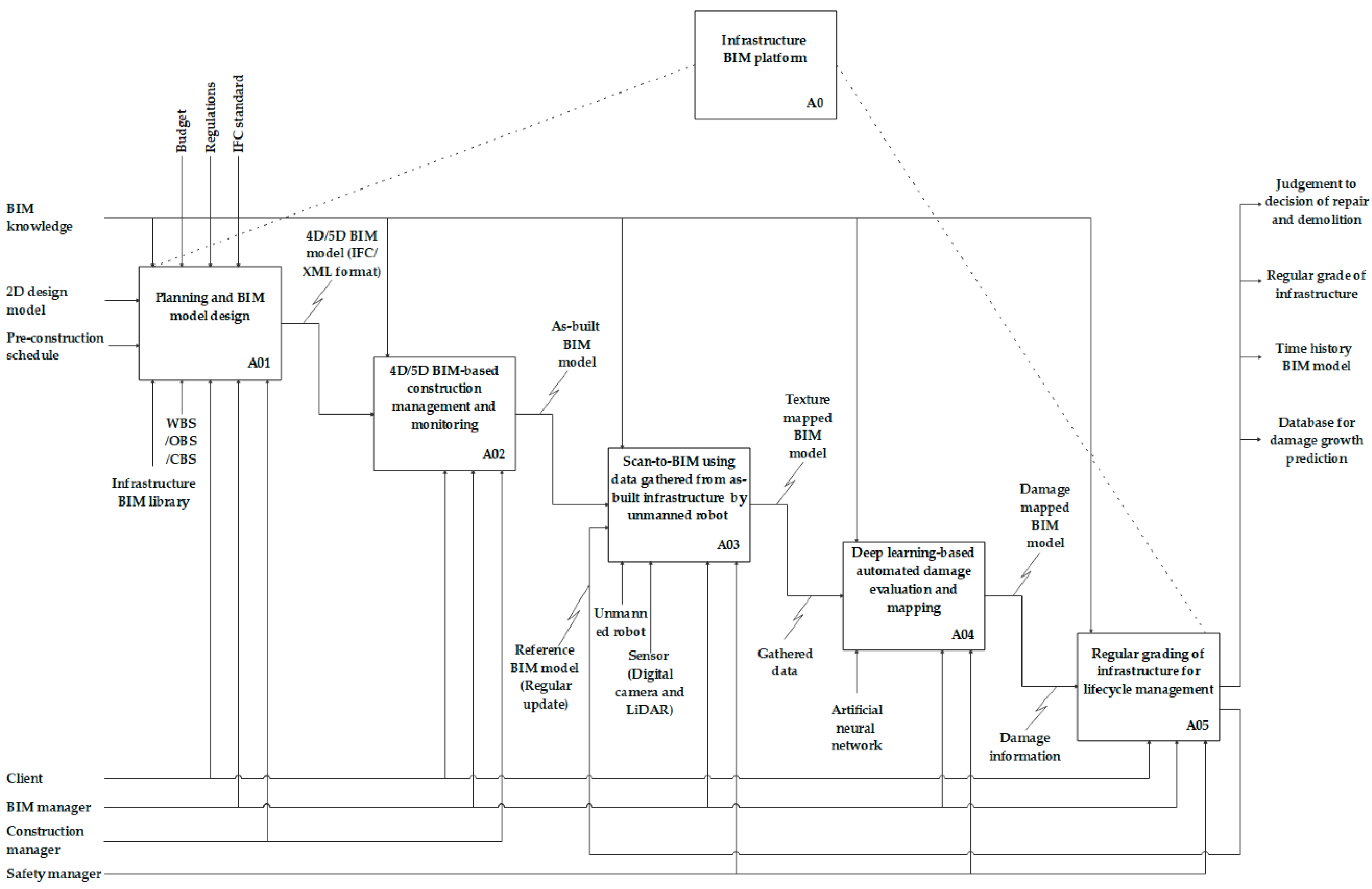
The infrastructure BIM platform was composed of five main activities: planning and BIM model design (A01); 4D/5D BIM-based construction management and monitoring (A02); scan-to-BIM using data gathered from as-built infrastructure by unmanned robots (A03); deep learning-based automated damage evaluation and mapping (A04); and annual grading of infrastructure for lifecycle management (A05), as shown in Figure 2. The infrastructure BIM platform is a web-based lifecycle management platform for the implementation of CDE. The framework includes the lifecycle management of infrastructure, from planning to demolition. First of all, a 4D/5D BIM model is designed using the 2D design model, pre-construction schedule, and a WBS/Organization Breakdown Structure (OBS)/Cost Breakdown Structure (CBS) by stakeholders (A01). Construction is then systematically performed using the 4D/5D BIM model (A02). The 4D/5D BIM model is shared with stakeholders as an international standard format (IFC and XML). At the completion stage, texture mapped BIM models are established using scanning data that were gathered by a sensor embedded in an unmanned robot (A03). Damage in the gathered data is automatically detected using a damage-trained deep learning network (A04). A damage mapped BIM model is then established by mapping detected damage to the BIM model. Infrastructure is graded regularly and managed by the law of each country. Therefore, the BIM model is updated regularly via repeated model updates, and the outdated BIM model becomes the reference model (A05). Details of the featured parts of the infrastructure BIM platform are sequentially explained.

4.1. Web-Based Infrastructure BIM Platform

An infrastructure BIM platform should be developed as a web-based platform for compatibility between a number of different stakeholders, such as clients, BIM managers, construction managers, and safety manager, etc. Moreover, a web-based platform that does not need other software can be accessed anytime and anywhere. Information and cost losses and errors during communication are significantly reduced using the web platform in the CDE.
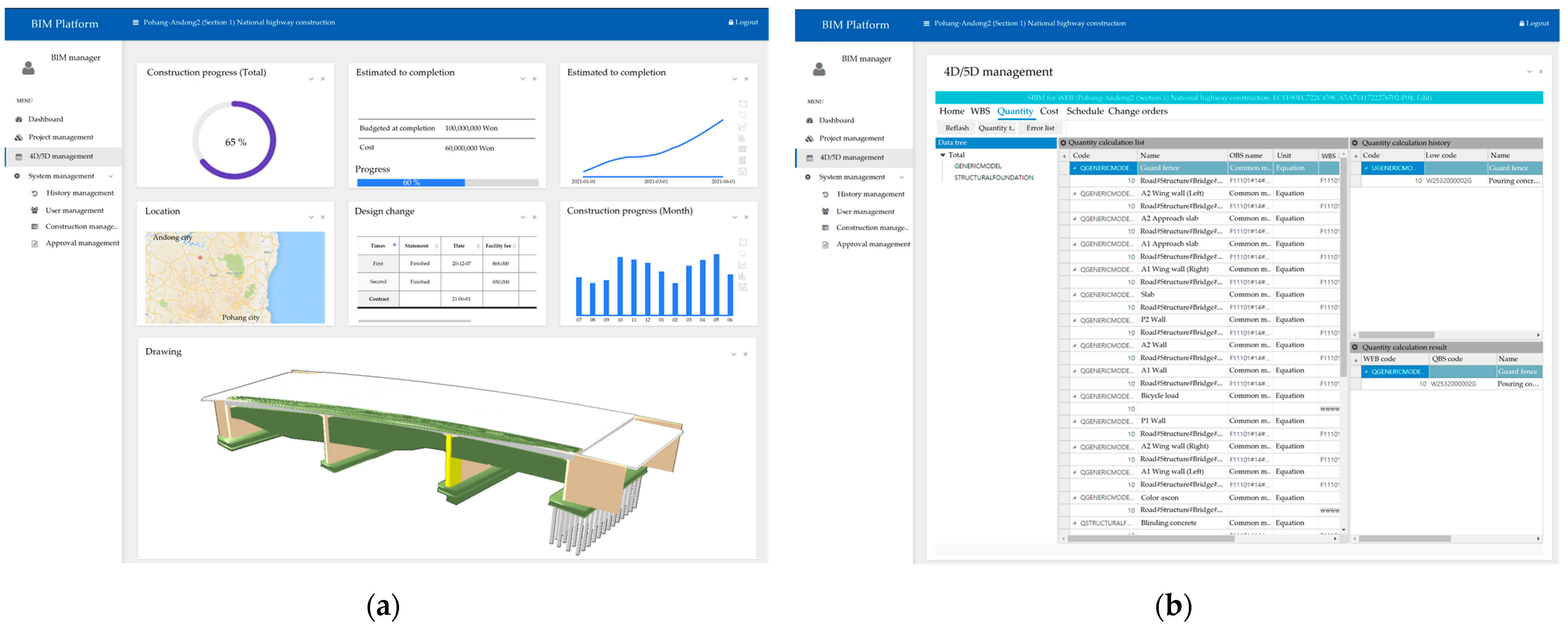
When the infrastructure project begins, stakeholders and projects are registered on the web-based infrastructure BIM platform. Every step of the projects and the information are then updated and shared with everyone. The IFC and XML files are uploaded after planning, and the designs are checked automatically for schema completeness by the IFC checker and viewer. If the uploaded file is accepted, summaries of the construction progress, location, schedule, cost, etc., are displayed on the dashboard, as shown in Figure 3a. The schedule (4D) and cost (5D) of infrastructure construction are managed based on WBS and CBS, which are already embedded in the calculation module of the infrastructure BIM platform. Therefore, when the IFC and XML files are uploaded, the quantity, schedule, and cost are automatically calculated by the calculation module.

4.2. Management of Infrastructure Using State-of-the-Art Techniques

After infrastructure construction is completed, damage is already present or begins to occur immediately. Therefore, an inspection of the infrastructure is performed, referring to the as-built BIM model shortly thereafter.
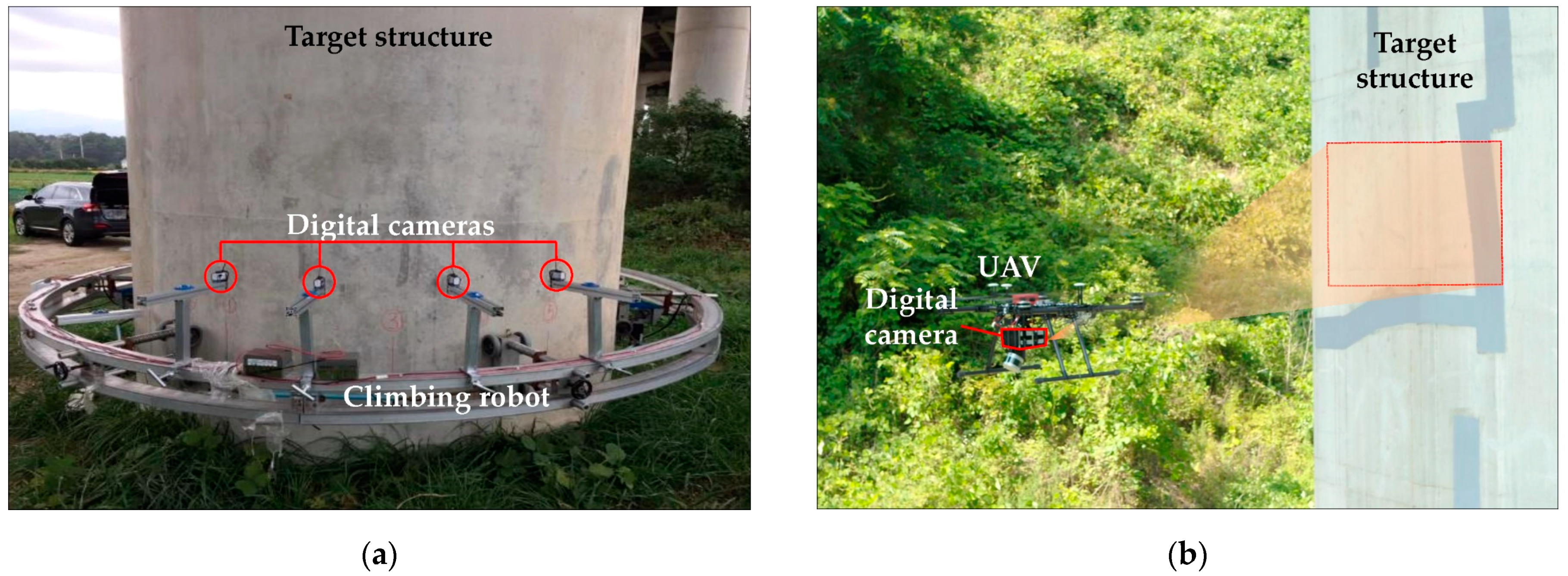
For the management of very large infrastructure, digital-camera-embedded robots are widely adopted, as shown in Figure 4. The BIM model is updated by data gathered by multi-digital cameras embedded in climbing robots, which scan the surface of bridge piers in the vertical direction, as shown in Figure 4a. Likewise, UAVs effectively scan the surface of bridges using only one digital camera to gather data. The gathered data are then used to build a 3D model using the photogrammetry algorithm.
Simultaneously, as shown in Figure 5a, damage is detected in the gathered data through a deep learning network, which is trained to detect multiple types of damage, such as cracking, spalling, rust, rebar exposure, etc. Figure 5b shows representative inference results of the deep learning network. The length and width of the damage is then calculated using image processing algorithms, using the segmented area (red zone) in the output image of Figure 5b [9]. Quantitative analysis results are saved for mapping onto the BIM model.
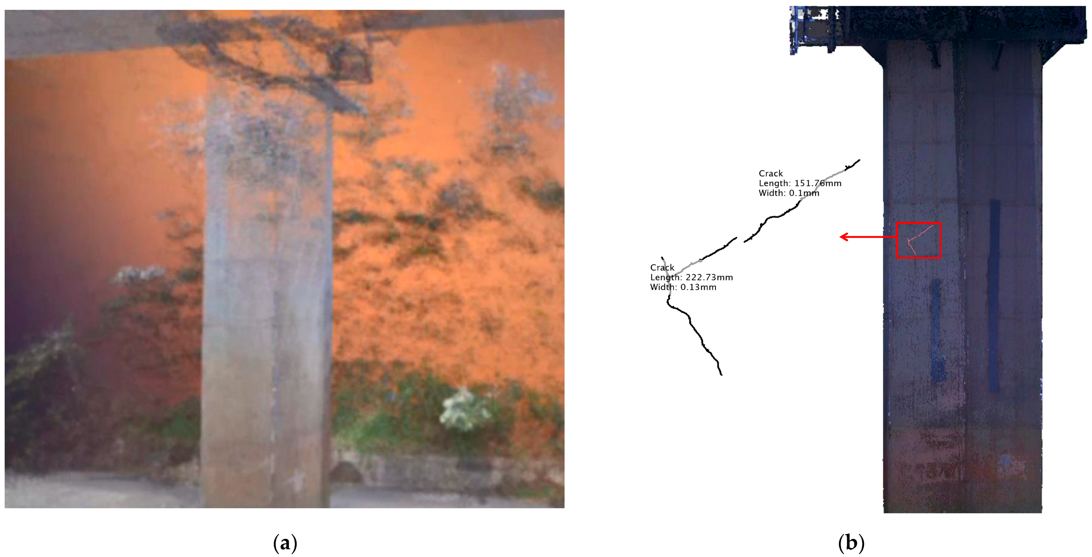
Figure 6a shows a representative point cloud model of a bridge pier generated by the photogrammetry algorithm. Figure 6b shows a texture- and damage-mapped BIM model. The damage information in Figure 6b is saved with the BIM model as a reference model for regular updates. In the future, the grade of the infrastructure is lowered due to the damage experiencing further growth, which will be used in the decision to repair or for demolition.

4.3. Future Work for Digital Twin

The establishment of a digital twin model is the goal of infrastructure lifecycle management; however, the digital twin model still only applies data sharing and visualization [62]. An artificial intelligence-based damage growth prediction algorithm is established using the stored time history data of the infrastructure BIM platform, as shown in Figure 2. The lifecycle management of the infrastructure can then be achieved in the digital domain by combining state-of-the-art techniques.

5. Discussion and Conclusions

This study presented an infrastructure Building Information Modeling (BIM) platform for lifecycle management. The web-based infrastructure BIM platform composed of planning and design, construction, and management methods was developed. It is a necessary development of BIM platform-based collaboration with stakeholders in the common data environment to efficiently lifecycle the management of infrastructure. Stakeholders can access and exchange essential information using the web-based BIM platform in real-time, making it possible to improve the efficiency of infrastructure lifecycle management. Recently, state-of-the-arts automation techniques have been widely adapted in the infrastructure management field. In particular, data acquisition has been automated by adopting various unmanned robots such as unmanned aerial vehicle (UAV) and climbing robot. Moreover, machine learning or deep learning networks make it possible to fully automate the corresponding data processing. However, systematic lifecycle management is still difficult using the proposed web-based BIM platform. Although there are tremendous trials on the initial stage of data management of infrastructures’ modeling, real-time or periodic data updating are still both technically challenging. To achieve the technical requirements, state-updated data acquisition as well as time-series data processing mythologies need to be developed. As a promising follow-up study, the authors of this paper are currently developing digital infrastructure twin modeling and updating technologies, which will be integrated with the proposed web-based BIM platform.

Author Contributions

K.J. and J.-W.K. established the research methodology; K.J., J.-W.K. and K.-B.J. performed the analysis of the literature; J.-W.K. developed the web-based infrastructure BIM platform; K.J. and Y.-K.A. developed the infrastructure management techniques; K.J. and Y.-K.A. wrote the paper; K.-B.J. and Y.-K.A. supervised the research. All authors have read and agreed to the published version of the manuscript.

Funding

This work is supported by the Korea Agency for Infrastructure Technology Advancement (KAIA) grant funded by the Ministry of Land, Infrastructure, and Transport (Grant 21SCIP-C121389-06).

Institutional Review Board Statement

Not applicable.

Informed Consent Statement

Not applicable.

Data Availability Statement

Not applicable.

Conflicts of Interest

The authors declare no conflict of interest.

References

  1. Costin, A.; Adibfar, A.; Hu, H.J.; Chen, S.S. Building Information Modeling (BIM) for transportation Infrastructure—Literature review, applications, challenges, and recommendations. Autom. Constr. 2018, 94, 257–281. [Google Scholar] [CrossRef]
  2. Bradley, A.; Li, H.J.; Lark, R.; Dunn, S. BIM for infrastructure: An overall review and constructor perspective. Autom. Constr. 2016, 71, 139–152. [Google Scholar] [CrossRef]
  3. Cheng, J.C.P.; Lu, Q.Q.; Deng, Y.C. Analytical review and evaluation of civil information modeling. Autom. Constr. 2016, 67, 31–47. [Google Scholar] [CrossRef]
  4. Stuart, S.; Chen, A.M.S. Integration of Information and Automation Technologies in Bridge Engineering and Management: Extending the State of the Art. J. Transp. Res. Board 2006, 1976, 3–12. [Google Scholar] [CrossRef]
  5. Hammad, A.; Zhang, C.; Hu, Y.X.; Mozaffari, E. Mobile model-based bridge lifecycle management system. Comput. Aided Civil. Infrastruct. Eng. 2006, 21, 530–547. [Google Scholar] [CrossRef]
  6. Breunig, M.; Borrmann, A.; Rank, E.; Hinz, S.; Kolbe, T.H.; Schilcher, M.; Mundani, R.P.; Jubierre, J.R.; Flurl, M.; Thomsen, A.; et al. Collaborative multi-scale 3D city and infrastructure modeling and simulation. In Proceedings of the International Archives of the Photogrammetry, Remote Sensing and Spatial Information Sciences, XLII-4/W4, Tehran, Iran, 7–10 October 2017; pp. 341–352. [Google Scholar]
  7. Vilgertshofer, S.; Borrmann, A. Using graph rewriting methods for the semi-automatic generation of parametric infrastructure models. Adv. Eng. Inform. 2017, 33, 502–515. [Google Scholar] [CrossRef]
  8. Li, H.; Chan, N.K.Y.; Huang, T.; Skitmore, M.; Yang, J. Virtual prototyping for planning bridge construction. Autom. Constr. 2012, 27, 1–10. [Google Scholar] [CrossRef] [Green Version]
  9. Jang, K.; An, Y.K.; Kim, B.; Cho, S. Automated crack evaluation of a high-rise bridge pier using a ring-type climbing robot. Comput.-Aided Civil. Infrastruct. Eng. 2021, 36, 14–29. [Google Scholar] [CrossRef]
  10. Bae, H.; Jang, K.; An, Y.K. Deep super resolution crack network (SrcNet) for improving computer vision-based automated crack detectability in in situ bridges. Struct. Health Monit. 2021, 20, 1428–1442. [Google Scholar] [CrossRef]
  11. Koch, C.; Paal, S.G.; Rashidi, A.; Zhu, Z.; Konig, M.; Brilakis, I. Achievements and Challenges in Machine Vision-Based Inspection of Large Concrete Structures. Adv. Struct. Eng. 2014, 17, 303–318. [Google Scholar] [CrossRef]
  12. Building Information Modeling Market by Component Deployment Mode, Project Life Cycle, Building Type, Application, and End User: Global Opportunity Analysis and Industry Forecast, 2020–2027; Allied Analytics LLP: Pune, India, 2020.
  13. Ministry of Land Infrastructure and Transport. Full-Scale Introduction of BIM in the Construction Industry, Full-Scale Promotion! Available online: http://www.molit.go.kr/USR/NEWS/m_71/dtl.jsp?id=95084979 (accessed on 23 September 2021).
  14. Shin, J.-Y.; Ju, K.-B.; Son, A.-Y.; Moon, H. A Study on the BIM Platform Required Functions and Application for Road and River Construction Project Management. J. Korean Inst. Commun. Inf. Sci. 2020, 45, 1893–1906. [Google Scholar] [CrossRef]
  15. Autodesk. Construction Management Software|Autodesk BIM 360. Available online: https://www.autodesk.com/bim-360/ (accessed on 23 September 2021).
  16. Trimble. Trimble Connect. Available online: https://connect.trimble.com/ (accessed on 23 September 2021).
  17. Bentley. Bently. Available online: https://www.bentley.com (accessed on 23 September 2021).
  18. Chihib, M.; Salmeron-Manzano, E.; Novas, N.; Manzano-Agugliaro, F. Bibliometric Maps of BIM and BIM in Universities: A Comparative Analysis. Sustainability 2019, 11, 4398. [Google Scholar] [CrossRef] [Green Version]
  19. Ahmed, H.; La, H.M.; Gucunski, N. Review of Non-Destructive Civil Infrastructure Evaluation for Bridges: State-of-the-Art Robotic Platforms, Sensors and Algorithms. Sensors 2020, 20, 3954. [Google Scholar] [CrossRef]
  20. Azimi, M.; Eslamlou, A.D.; Pekcan, G. Data-Driven Structural Health Monitoring and Damage Detection through Deep Learning: State-of-the-Art Review. Sensors 2020, 20, 2778. [Google Scholar] [CrossRef]
  21. Haussler, M.; Borrmann, A. Model-based quality assurance in railway infrastructure planning. Autom. Constr. 2020, 109, 2971. [Google Scholar] [CrossRef]
  22. Park, S.I.; Park, J.; Kim, B.G.; Lee, S.H. Improving Applicability for Information Model of an IFC-Based Steel Bridge in the Design Phase Using Functional Meanings of Bridge Components. Appl. Sci. 2018, 8, 2531. [Google Scholar] [CrossRef] [Green Version]
  23. Borrmann, A.; Kolbe, T.H.; Donaubauer, A.; Steuer, H.; Jubierre, J.R.; Flurl, M. Multi-Scale Geometric-Semantic Modeling of Shield Tunnels for GIS and BIM Applications. Comput.-Aided Civil. Infrastruct. Eng. 2015, 30, 263–281. [Google Scholar] [CrossRef]
  24. Nath, T.; Attarzadeh, M.; Tiong, R.L.K.; Chidambaram, C.; Yu, Z. Productivity improvement of precast shop drawings generation through BIM-based process re-engineering. Autom. Constr. 2015, 54, 54–68. [Google Scholar] [CrossRef]
  25. Girardet, A.; Boton, C. A parametric BIM approach to foster bridge project design and analysis. Autom. Constr. 2021, 126, 103679. [Google Scholar] [CrossRef]
  26. Shin, M.H.; Lee, H.K.; Kim, H.Y. Benefit-Cost Analysis of Building Information Modeling (BIM) in a Railway Site. Sustainability 2018, 10, 4303. [Google Scholar] [CrossRef] [Green Version]
  27. Lee, K.M.; Lee, Y.B.; Shim, C.S.; Park, K.L. Bridge information models for construction of a concrete box-girder bridge. Struct. Infrastruct. Eng. 2012, 8, 687–703. [Google Scholar] [CrossRef]
  28. Liu, A.H.; Ellul, C.; Swiderska, M. Decision Making in the 4th Dimension-Exploring Use Cases and Technical Options for the Integration of 4D BIM and GIS during Construction. ISPRS Int. J. Geo-Inf. 2021, 10, 203. [Google Scholar] [CrossRef]
  29. Koch, C.; Vonthron, A.; Konig, M. A tunnel information modelling framework to support management, simulations and visualisations in mechanised tunnelling projects. Autom. Constr. 2017, 83, 78–90. [Google Scholar] [CrossRef]
  30. Marzouk, M.; Hisham, M. Implementing earned value management using bridge information modeling. KSCE J. Civ. Eng. 2014, 18, 1302–1313. [Google Scholar] [CrossRef]
  31. Mawlana, M.; Vandatikhaki, F.; Doriani, A.; Hammad, A. Integrating 4D modeling and discrete event simulation for phasing evaluation of elevated urban highway reconstruction projects. Autom. Constr. 2015, 60, 25–38. [Google Scholar] [CrossRef]
  32. Ding, L.Y.; Zhou, Y.; Luo, H.B.; Wu, X.G. Using nD technology to develop an integrated construction management system for city rail transit construction. Autom. Constr. 2012, 21, 64–73. [Google Scholar] [CrossRef]
  33. Valdepenas, P.; Perez, M.D.E.; Henche, C.; Rodriguez-Escribano, R.; Fernandez, G.; Lopez-Gutierrez, J.S. Application of the BIM Method in the Management of the Maintenance in Port Infrastructures. J. Mar. Sci. Eng. 2020, 8, 981. [Google Scholar] [CrossRef]
  34. Lee, P.C.; Wang, Y.H.; Lo, T.P.; Long, D.B. An integrated system framework of building information modelling and geographical information system for utility tunnel maintenance management. Tunn. Undergr. Space Technol. 2018, 79, 263–273. [Google Scholar] [CrossRef]
  35. Sharafat, A.; Khan, M.S.; Latif, K.; Tanoli, W.A.; Park, W.; Seo, J. BIM-GIS-Based Integrated Framework for Underground Utility Management System for Earthwork Operations. Appl. Sci. 2021, 11, 5721. [Google Scholar] [CrossRef]
  36. Boddupalli, C.; Sadhu, A.; Azar, E.R.; Pattyson, S. Improved visualization of infrastructure monitoring data using building information modeling. Struct. Infrastruct. Eng. 2019, 15, 1247–1263. [Google Scholar] [CrossRef]
  37. Kaewunruen, S.; Sresakoolchai, J.; Zhou, Z.H. Sustainability-Based Lifecycle Management for Bridge Infrastructure Using 6D BIM. Sustainability 2020, 12, 2436. [Google Scholar] [CrossRef] [Green Version]
  38. Kim, I.H.; Jeon, H.; Baek, S.C.; Hong, W.H.; Jung, H.J. Application of Crack Identification Techniques for an Aging Concrete Bridge Inspection Using an Unmanned Aerial Vehicle. Sensors 2018, 18, 1881. [Google Scholar] [CrossRef] [Green Version]
  39. Jiang, S.; Zhang, J. Real-time crack assessment using deep neural networks with wall-climbing unmanned aerial system. Comput.-Aided Civil. Infrastruct. Eng. 2020, 35, 549–564. [Google Scholar] [CrossRef]
  40. Ribeiro, D.; Santos, R.; Shibasaki, A.; Montenegro, P.; Carvalho, H.; Calcada, R. Remote inspection of RC structures using unmanned aerial vehicles and heuristic image processing. Eng. Fail. Anal. 2020, 117, 104813. [Google Scholar] [CrossRef]
  41. Braun, A.; Borrmann, A. Combining inverse photogrammetry and BIM for automated labeling of construction site images for machine learning. Autom. Constr. 2019, 106, 102879. [Google Scholar] [CrossRef]
  42. Lee, S.B.; Song, M.; Kim, S.; Won, J.H. Change Monitoring at Expressway Infrastructure Construction Sites Using Drone. Sens. Mater. 2020, 32, 3923–3933. [Google Scholar] [CrossRef]
  43. Soilan, M.; Justo, A.; Sanchez-Rodriguez, A.; Riveiro, B. 3D Point Cloud to BIM: Semi-Automated Framework to Define IFC Alignment Entities from MLS-Acquired LiDAR Data of Highway Roads. Remote Sens. 2020, 12, 2301. [Google Scholar] [CrossRef]
  44. Chen, K.; Lu, W.S.; Xue, F.; Tang, P.B.; Li, L.H. Automatic building building information model reconstruction in high-density urban areas: Augmenting multi-source data with architectural knowledge. Autom. Constr. 2018, 93, 22–34. [Google Scholar] [CrossRef]
  45. Cha, Y.J.; Choi, W.; Buyukozturk, O. Deep Learning-Based Crack Damage Detection Using Convolutional Neural Networks. Comput.-Aided Civil. Infrastruct. Eng. 2017, 32, 361–378. [Google Scholar] [CrossRef]
  46. Kim, B.; Cho, S. Automated Vision-Based Detection of Cracks on Concrete Surfaces Using a Deep Learning Technique. Sensors 2018, 18, 3452. [Google Scholar] [CrossRef] [Green Version]
  47. Jang, K.; Kim, N.; An, Y.K. Deep learning-based autonomous concrete crack evaluation through hybrid image scanning. Struct. Health Monit. 2019, 18, 1722–1737. [Google Scholar] [CrossRef]
  48. Dorafshan, S.; Thomas, R.J.; Maguire, M. Comparison of deep convolutional neural networks and edge detectors for image-based crack detection in concrete. Constr. Build. Mater. 2018, 186, 1031–1045. [Google Scholar] [CrossRef]
  49. Hoang, N.D.; Nguyen, Q.L.; Tran, V.D. Automatic recognition of asphalt pavement cracks using metaheuristic optimized edge detection algorithms and convolution neural network. Autom. Constr. 2018, 94, 203–213. [Google Scholar] [CrossRef]
  50. Deng, L.; Chu, H.H.; Shi, P.; Wang, W.; Kong, X. Region-Based CNN Method with Deformable Modules for Visually Classifying Concrete Cracks. Appl. Sci. 2020, 10, 2528. [Google Scholar] [CrossRef] [Green Version]
  51. Deng, J.H.; Lu, Y.; Lee, V.C.S. Imaging-based crack detection on concrete surfaces using You Only Look Once network. Struct. Health Monit. 2021, 20, 484–499. [Google Scholar] [CrossRef]
  52. Fang, F.; Li, L.Y.; Gu, Y.; Zhu, H.Y.; Lim, J.H. A novel hybrid approach for crack detection. Pattern Recognit. 2020, 107. [Google Scholar] [CrossRef]
  53. Cha, Y.J.; Choi, W.; Suh, G.; Mahmoudkhani, S.; Buyukozturk, O. Autonomous Structural Visual Inspection Using Region-Based Deep Learning for Detecting Multiple Damage Types. Comput.-Aided Civil. Infrastruct. Eng. 2018, 33, 731–747. [Google Scholar] [CrossRef]
  54. Zhang, C.B.; Chang, C.C.; Jamshidi, M. Concrete bridge surface damage detection using a single-stage detector. Comput.-Aided Civil. Infrastruct. Eng. 2020, 35, 389–409. [Google Scholar] [CrossRef]
  55. Dung, C.V.; Anh, L.D. Autonomous concrete crack detection using deep fully convolutional neural network. Autom. Constr. 2019, 99, 52–58. [Google Scholar] [CrossRef]
  56. Islam, M.M.M.; Kim, J.M. Vision-Based Autonomous Crack Detection of Concrete Structures Using a Fully Convolutional Encoder-Decoder Network. Sensors 2019, 19, 4251. [Google Scholar] [CrossRef] [Green Version]
  57. Feng, C.C.; Zhang, H.; Wang, H.R.; Wang, S.; Li, Y.L. Automatic Pixel-Level Crack Detection on Dam Surface Using Deep Convolutional Network. Sensors 2020, 20, 2069. [Google Scholar] [CrossRef] [PubMed] [Green Version]
  58. Li, S.Y.; Zhao, X.F.; Zhou, G.Y. Automatic pixel-level multiple damage detection of concrete structure using fully convolutional network. Comput.-Aided Civil. Infrastruct. Eng. 2019, 34, 616–634. [Google Scholar] [CrossRef]
  59. Choi, W.; Cha, Y.J. SDDNet: Real-Time Crack Segmentation. IEEE Trans. Ind. Electron. 2020, 67, 8016–8025. [Google Scholar] [CrossRef]
  60. Kang, D.H.; Cha, Y.J. Autonomous UAVs for Structural Health Monitoring Using Deep Learning and an Ultrasonic Beacon System with Geo-Tagging. Comput.-Aided Civil. Infrastruct. Eng. 2018, 33, 885–902. [Google Scholar] [CrossRef]
  61. Borrmann, A.; König, M.; Koch, C.; Beetz, J. Building Information Modeling: Technology Foundations and Industry Practice; Springer: Berlin, Germany, 2018; pp. 63–78. [Google Scholar]
  62. Kaewunruen, S.; Sresakoolchai, J.; Ma, W.T.; Phil-Ebosie, O. Digital Twin Aided Vulnerability Assessment and Risk-Based Maintenance Planning of Bridge Infrastructures Exposed to Extreme Conditions. Sustainability 2021, 13, 2051. [Google Scholar] [CrossRef]
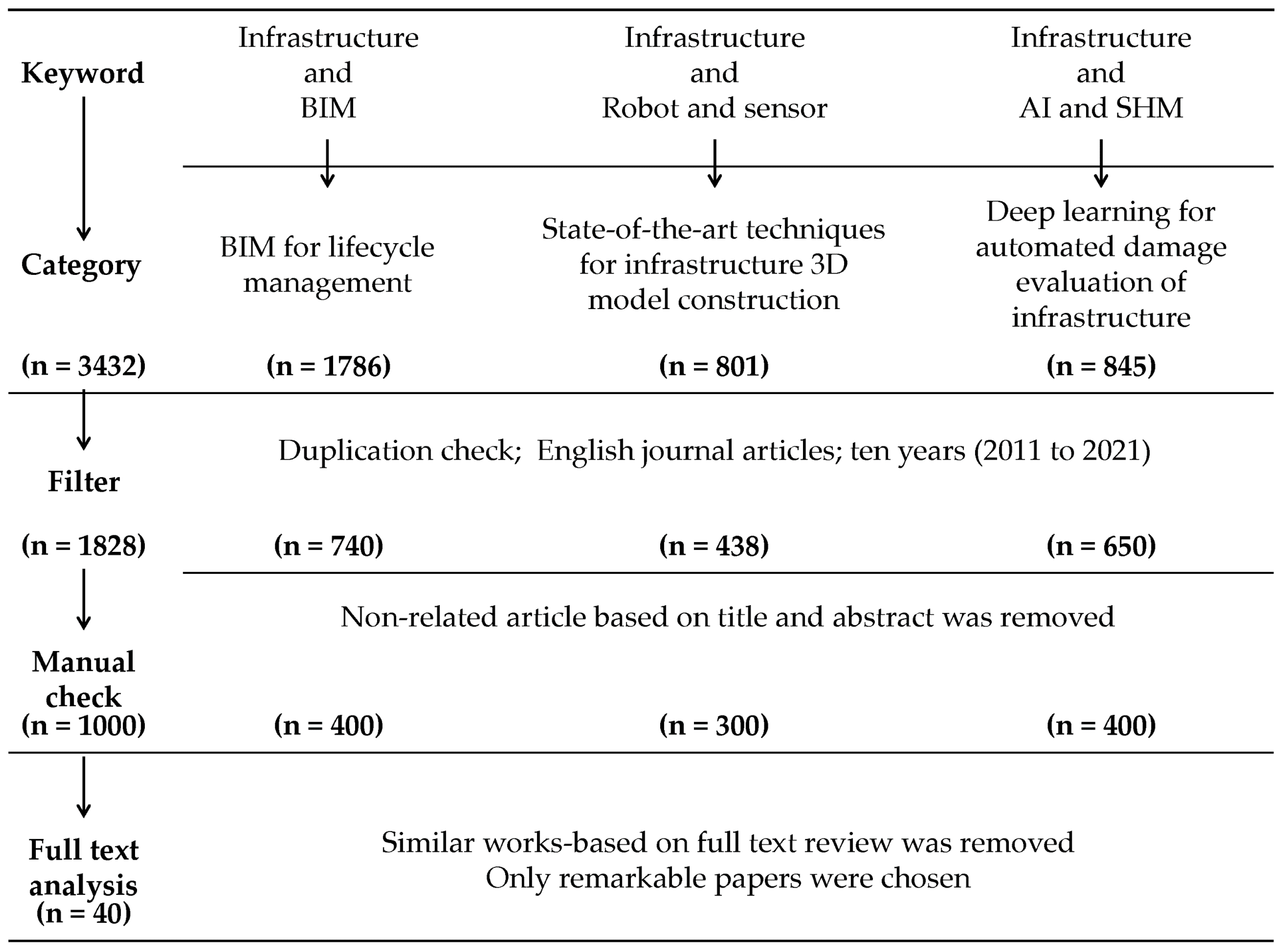
Figure 1. Methodology flow diagram.
Applsci 11 10310 g001
Figure 2. IDEF0 diagram of the infrastructure BIM platform.
Applsci 11 10310 g002
Figure 3. Representative page of web-based infrastructure BIM platform: (a) dashboard and (b) quantity takeoff page.
Applsci 11 10310 g003
Figure 4. Unmanned robot system for data acquisition: (a) climbing robot with multiple digital cameras; (b) unmanned arial vehicles with digital camera.
Applsci 11 10310 g004
Figure 5. Deep learning-based automated damage detection: (a) network architecture; (b) automated damage detection result.
Applsci 11 10310 g005
Figure 6. Scan-to-BIM model: (a) point cloud model generated using the photogrammetry algorithm using digital images acquired by a digital camera embedded on a UAV; (b) texture- and damage-mapped BIM model.
Applsci 11 10310 g006
Table 1. Keywords for each topic.
TopicKeyword
InfrastructureInfrastructure; Bridge; Tunnel; Road; Railway
BIMBuilding Information Modelling (BIM); Bridge Information Modeling (BrIM); Civil Information Modeling (CIM); Planning; Design; Construction; Management; Industry Foundation Classes (IFC)
Robot and sensorVision camera; Digital camera; 3D LiDAR; Point cloud; Unmanned robot; Unmanned Aerial Vehicles (UAV); Photogrammetry; Structure-from-Motion (SfM); Scan-to-BIM
AI and SHMDeep learning; Convolutional neural network (CNN); Structural Health Monitoring (SHM); Damage detection; Anomaly detection; Damage evaluation; Crack; Efflorescence; Rust; Leakage; Spalling
Publisher’s Note: MDPI stays neutral with regard to jurisdictional claims in published maps and institutional affiliations.