
When Intelligent Transportation Systems Sensing Meets Edge Computing: Vision and Challenges


Abstract
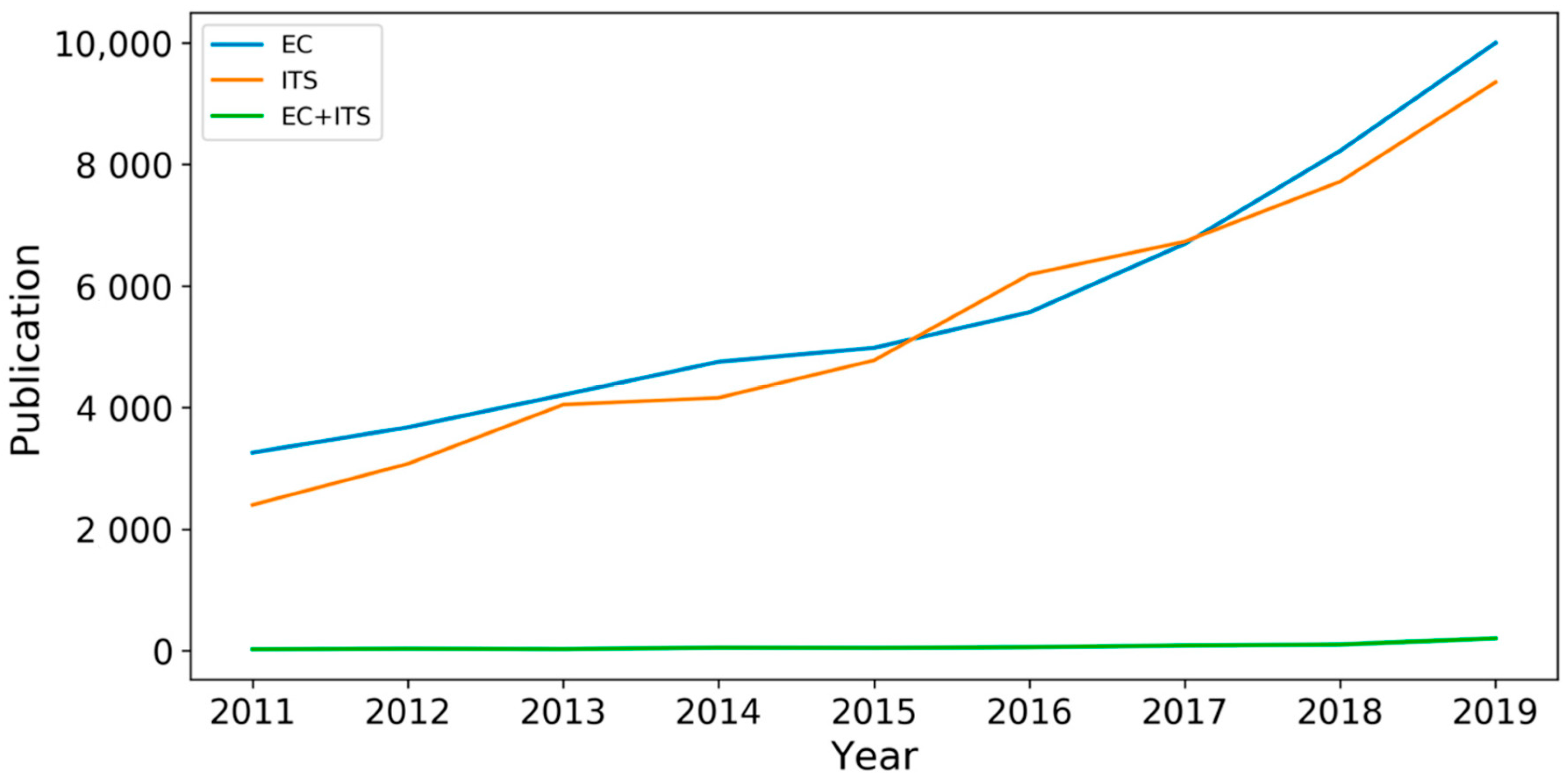
:1. Introduction
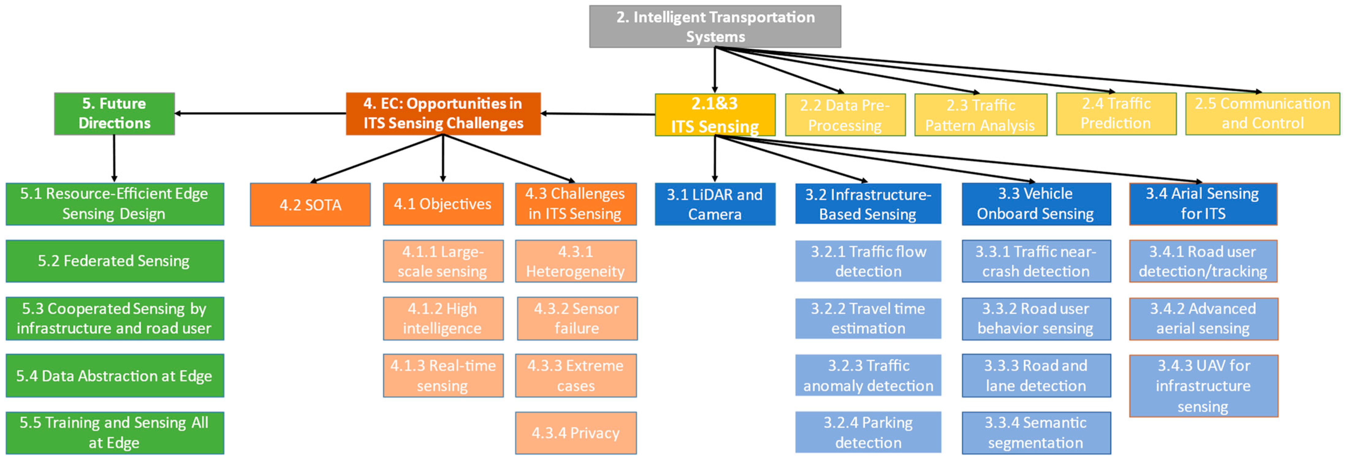
2. Intelligent Transportation Systems (ITS)
2.1. Sensing
2.2. Data Pre-Processing
2.3. Traffic Pattern Analysis
2.4. Traffic Prediction
2.5. Information Communication and Control
3. ITS Sensing
3.1. LiDAR and Camera
3.2. Infrastructure-Based ITS Sensing
3.2.1. Traffic Flow Detection
3.2.2. Travel Time Estimation
3.2.3. Traffic Anomaly Detection
3.2.4. Parking Detection
3.3. Vehicle Onboard Sensing
3.3.1. Traffic Near-Crash Detection
3.3.2. Road User Behavior Sensing
3.3.3. Road and Lane Detection
3.3.4. Semantic Segmentation
3.4. Aerial Sensing for ITS
3.4.1. Road User Detection and Tracking
3.4.2. Advanced Aerial Sensing
3.4.3. UAV for Infrastructure Sensing
4. Edge Computing: Opportunities in ITS Sensing Challenges
4.1. Objectives
4.1.1. Large-Scale Sensing
4.1.2. High Intelligence
4.1.3. Real-Time Sensing
4.2. State of the Art
4.3. Challenges in ITS Sensing
4.3.1. Challenge 1: Heterogeneity
4.3.2. Challenge 2: High Probability of Sensor Failure
4.3.3. Challenge 3: Sensing in Extreme Cases
4.3.4. Challenge 4: Privacy Protection
5. Future Research Directions
5.1. Resource-Efficient Edge Sensing Design
5.2. Federated Sensing
5.3. Cooperated Sensing by Infrastructure and Road Users
5.4. ITS Sensing Data Abstraction at Edge
5.5. Training and Sensing All at Edge
6. Conclusions
Author Contributions
Funding
Institutional Review Board Statement
Informed Consent Statement
Data Availability Statement
Conflicts of Interest
References
- Shi, W.; Cao, J.; Zhang, Q.; Li, Y.; Xu, L. Edge Computing: Vision and Challenges. IEEE Internet Things J. 2016, 3, 637–646. [Google Scholar] [CrossRef]
- Zhou, Z.; Chen, X.; Li, E.; Zeng, L.; Luo, K.; Zhang, J. Edge intelligence: Paving the last mile of artificial intelligence with edge computing. arXiv 2019, 107, 1738–1762. [Google Scholar] [CrossRef] [Green Version]
- Abbas, N.; Zhang, Y.; Taherkordi, A.; Skeie, T. Mobile edge computing: A survey. IEEE Internet Things J. 2017, 5, 450–465. [Google Scholar] [CrossRef] [Green Version]
- Ke, R.; Zhuang, Y.; Pu, Z.; Wang, Y. A Smart, Efficient, and Reliable Parking Surveillance System with Edge Artificial Intelligence on IoT Devices. IEEE Trans. Intell. Transp. Syst. 2021, 22, 4962–4974. [Google Scholar] [CrossRef] [Green Version]
- Ananthanarayanan, G.; Bahl, P.; Bodik, P.; Chintalapudi, K.; Philipose, M.; Ravindranath, L.; Sinha, S. Real-time video analytics: The killer app for edge computing. Computer 2017, 50, 58–67. [Google Scholar] [CrossRef]
- Ji, B.; Han, Y.; Wang, Y.; Cao, D.; Tao, F.; Fu, Z.; Li, P.; Wen, H. Relay Cooperative Transmission Algorithms for IoV Under Aggregated Interference. IEEE Trans. Intell. Transp. Syst. 2021, 1–14. [Google Scholar] [CrossRef]
- Dai, Y.; Xu, D.; Maharjan, S.; Qiao, G.; Zhang, Y. Artificial Intelligence Empowered Edge Computing and Caching for Internet of Vehicles. IEEE Wirel. Commun. 2019, 3, 12–18. [Google Scholar] [CrossRef]
- Al-Turjman, F.; Malekloo, A. Smart parking in IoT-enabled cities: A survey. Sustain. Cities Soc. 2019, 49, 101608. [Google Scholar] [CrossRef]
- Ke, R. Real-Time Video Analytics Empowered by Machine Learning and Edge Computing for Smart Transportation Applications; University of Washington: Seattle, WA, USA, 2020. [Google Scholar]
- Ban, X.J.; Herring, R.; Margulici, J.D.; Bayen, A.M. Optimal Sensor Placement for Freeway Travel Time Estimation. In Transportation and Traffic Theory 2009: Golden Jubilee; Springer: Berlin/Heidelberg, Germany, 2009; pp. 697–721. [Google Scholar]
- Sharma, A.; Bullock, D.M.; Bonneson, J.A. Input-output and hybrid techniques for real-time prediction of delay and maximum queue length at signalized intersections. Transp. Res. Rec. 2007, 2035, 69–80. [Google Scholar] [CrossRef] [Green Version]
- Wang, Y.; Nihan, N.L. Freeway traffic speed estimation with single-loop outputs. Transp. Res. Rec. 2000, 1727, 120–126. [Google Scholar] [CrossRef]
- Cheung, S.Y.; Coleri, S.; Dundar, B.; Ganesh, S.; Tan, C.W.; Varaiya, P. Traffic measurement and vehicle classification with single magnetic sensor. Transp. Res. Rec. 2005, 1917, 173–181. [Google Scholar] [CrossRef]
- Haoui, A.; Kavaler, R.; Varaiya, P. Wireless magnetic sensors for traffic surveillance. Transp. Res. Part C Emerg. Technol. 2008, 16, 294–306. [Google Scholar] [CrossRef]
- Buch, N.; Velastin, S.A.; Orwell, J. A review of computer vision techniques for the analysis of urban traffic. IEEE Trans. Intell. Transp. Syst. 2011, 12, 920–939. [Google Scholar] [CrossRef]
- Datondji, S.R.E.; Dupuis, Y.; Subirats, P.; Vasseur, P. A Survey of Vision-Based Traffic Monitoring of Road Intersections. IEEE Trans. Intell. Transp. Syst. 2016, 17, 2681–2698. [Google Scholar] [CrossRef]
- Odat, E.; Shamma, J.S.; Claudel, C. Vehicle Classification and Speed Estimation Using Combined Passive Infrared/Ultrasonic Sensors. IEEE Trans. Intell. Transp. Syst. 2018, 19, 1593–1606. [Google Scholar] [CrossRef]
- Zhao, J.; Xu, H.; Liu, H.; Wu, J.; Zheng, Y.; Wu, D. Detection and tracking of pedestrians and vehicles using roadside LiDAR sensors. Transp. Res. Part C Emerg. Technol. 2019, 100, 68–87. [Google Scholar] [CrossRef]
- Sen, R.; Siriah, P.; Raman, B. RoadSoundSense: Acoustic sensing based road congestion monitoring in developing regions. In Proceedings of the 8th Annual IEEE Communications Society Conference on Sensor, Mesh and Ad Hoc Communications and Networks, Salt Lake City, UT, USA, 27–30 June 2011; pp. 125–133. [Google Scholar] [CrossRef] [Green Version]
- Malinovskiy, Y.; Saunier, N.; Wang, Y. Analysis of pedestrian travel with static bluetooth sensors. Transp. Res. Rec. 2012, 2299, 137–149. [Google Scholar] [CrossRef]
- Dunlap, M.; Li, Z.; Henrickson, K.; Wang, Y. Estimation of origin and destination information from bluetooth and wi-fi sensing for transit. Transp. Res. Rec. 2016, 2595, 11–17. [Google Scholar] [CrossRef]
- Herrera, J.C.; Work, D.B.; Herring, R.; Ban, X.; Jacobson, Q.; Bayen, A.M. Evaluation of traffic data obtained via GPS-enabled mobile phones: The Mobile Century field experiment. Transp. Res. Part C Emerg. Technol. 2010, 18, 568–583. [Google Scholar] [CrossRef] [Green Version]
- Kamyab, M.; Remias, S.; Najmi, E.; Rabinia, S.; Waddell, J.M. Machine learning approach to forecast work zone mobility using probe vehicle data. Transp. Res. Rec. 2020, 2674, 157–167. [Google Scholar] [CrossRef]
- McCormack, E.; Hallenbeck, M.E. ITS devices used to collect truck data for performance benchmarks. Transp. Res. Rec. 2006, 1957, 43–50. [Google Scholar] [CrossRef]
- Ban, X.J.; Hao, P.; Sun, Z. Real time queue length estimation for signalized intersections using travel times from mobile sensors. Transp. Res. Part C Emerg. Technol. 2011, 19, 1133–1156. [Google Scholar]
- Chen, X.; Wu, S.; Shi, C.; Huang, Y.; Yang, Y.; Ke, R.; Zhao, J. Sensing Data Supported Traffic Flow Prediction via Denoising Schemes and ANN: A Comparison. IEEE Sens. J. 2020, 20, 14317–14328. [Google Scholar] [CrossRef]
- Taguchi, S.; Koide, S.; Yoshimura, T. Online Map Matching with Route Prediction. IEEE Trans. Intell. Transp. Syst. 2019, 20, 338–347. [Google Scholar] [CrossRef]
- Goh, C.Y.; Dauwels, J.; Mitrovic, N.; Asif, M.T.; Oran, A.; Jaillet, P. Online map-matching based on hidden Markov model for real-time traffic sensing applications. In Proceedings of the 2012 15th International IEEE Conference on Intelligent Transportation Systems, ITSC 2012, Anchorage, AK, USA, 16–19 September 2012; pp. 776–781. [Google Scholar] [CrossRef] [Green Version]
- Mohamed, R.; Aly, H.; Youssef, M. Accurate Real-Time Map Matching for Challenging Environments. IEEE Trans. Intell. Transp. Syst. 2017, 18, 847–857. [Google Scholar] [CrossRef]
- Duan, Y.; Lv, Y.; Liu, Y.-L.; Wang, F.-Y. An efficient realization of deep learning for traffic data imputation. Transp. Res. Part C Emerg. Technol. 2016, 72, 168–181. [Google Scholar] [CrossRef]
- Chen, Y.; Lv, Y.; Wang, F.Y. Traffic Flow Imputation Using Parallel Data and Generative Adversarial Networks. IEEE Trans. Intell. Transp. Syst. 2020, 21, 1624–1630. [Google Scholar] [CrossRef]
- Zhuang, Y.; Ke, R.; Wang, Y. Innovative method for traffic data imputation based on convolutional neural network. IET Intell. Transp. Syst. 2018, 13, 605–613. [Google Scholar] [CrossRef]
- Asadi, R.; Regan, A. A convolution recurrent autoencoder for spatio-temporal missing data imputation. arXiv 2019, arXiv:1904.12413. [Google Scholar]
- Chen, X.; Yang, J.; Sun, L. A nonconvex low-rank tensor completion model for spatiotemporal traffic data imputation. Transp. Res. Part C Emerg. Technol. 2020, 117, 102673. [Google Scholar] [CrossRef]
- Zhang, K.; He, Z.; Zheng, L.; Zhao, L.; Wu, L. A generative adversarial network for travel times imputation using trajectory data. Comput. Civ. Infrastruct. Eng. 2020, 36, 197–212. [Google Scholar] [CrossRef]
- Torres, R.; Ohashi, O.; Pessin, G. A machine-learning approach to distinguish passengers and drivers reading while driving. Sensors 2019, 19, 3174. [Google Scholar] [CrossRef] [PubMed] [Green Version]
- Zhao, W.; McCormack, E.; Dailey, D.J.; Scharnhorst, E. Using truck probe gps data to identify and rank roadway bottlenecks. J. Transp. Eng. 2013, 139, 1–7. [Google Scholar] [CrossRef] [Green Version]
- Hsu, Y.W.; Chen, Y.W.; Perng, J.W. Estimation of the number of passengers in a bus using deep learning. Sensors 2020, 20, 2178. [Google Scholar] [CrossRef] [PubMed] [Green Version]
- Sargolzaei, A.; Crane, C.D.; Abbaspour, A.; Noei, S. A machine learning approach for fault detection in vehicular cyber-physical systems. In Proceedings of the 15th IEEE International Conference on Machine Learning and Applications (ICMLA), Anaheim, CA, USA, 18–20 December 2016; pp. 636–640. [Google Scholar] [CrossRef]
- Jahangiri, A.; Rakha, H.A. Transportation Mode Recognition Using Mobile Phone Sensor Data. IEEE Trans. Intell. Transp. Syst. 2015, 16, 2406–2417. [Google Scholar] [CrossRef]
- Ashqar, H.I.; Almannaa, M.H.; Elhenawy, M.; Rakha, H.A. Smartphone Transportation Mode Recognition Using a Hierarchical Machine Learning Classifier and Pooled Features from Time and Frequency Domains. arXiv 2020, 20, 244–252. [Google Scholar] [CrossRef] [Green Version]
- Chen, Z.; Wang, S.; Shen, Z.; Chen, Y.; Zhao, Z. Online sequential ELM based transfer learning for transportation mode recognition. In Proceedings of the IEEE Conference on Cybernetics and Intelligent Systems (CIS), Manila, Philippines, 12–15 November 2013; pp. 78–83. [Google Scholar] [CrossRef]
- Jeyakumar, J.V.; Sandha, S.S.; Lee, E.S.; Tausik, N.; Xia, Z.; Srivastava, M. Deep convolutional bidirectional LSTM based transportation mode recognition. In Proceedings of the 2018 ACM International Joint Conference and 2018 International Symposium on Pervasive and Ubiquitous Computing and Wearable Computers. Singapore, 8–12 October 2018; pp. 1606–1615. [Google Scholar] [CrossRef]
- Parsa, A.B.; Movahedi, A.; Taghipour, H.; Derrible, S.; Mohammadian, A. (Kouros) Toward safer highways, application of XGBoost and SHAP for real-time accident detection and feature analysis. Accid. Anal. Prev. 2020, 136, 105405. [Google Scholar] [CrossRef]
- Parsa, A.B.; Taghipour, H.; Derrible, S.; Mohammadian, A. (Kouros) Real-time accident detection: Coping with imbalanced data. Accid. Anal. Prev. 2019, 129, 202–210. [Google Scholar] [CrossRef]
- Zhang, Z.; He, Q.; Gao, J.; Ni, M. A deep learning approach for detecting traffic accidents from social media data. Transp. Res. Part C Emerg. Technol. 2018, 86, 580–596. [Google Scholar] [CrossRef] [Green Version]
- Dogru, N.; Subasi, A. Traffic accident detection using random forest classifier. In Proceedings of the 15th Learning and Technology Conference (L&T), Jeddah, Saudi Arabia, 25–26 February 2018; pp. 40–45. [Google Scholar] [CrossRef]
- Zhang, Z.; Li, M.; Lin, X.; Wang, Y.; He, F. Multistep Speed Prediction on Traffic Networks: A Graph Convolutional Sequence-to-Sequence Learning Approach with Attention Mechanism. arXiv 2018, arXiv:1810.10237 . [Google Scholar]
- Cui, Z.; Ke, R.; Pu, Z.; Wang, Y. Stacked Bidirectional and Unidirectional LSTM Recurrent Neural Network for Forecasting Network-Wide Traffic State with Missing Values. Transp. Res. Part C Emerg. Technol. 2020, 118, 102674. [Google Scholar] [CrossRef]
- Lv, Y.; Duan, Y.; Kang, W.; Li, Z.; Wang, F.Y. Traffic Flow Prediction with Big Data: A Deep Learning Approach. IEEE Trans. Intell. Transp. Syst. 2015, 16, 865–873. [Google Scholar] [CrossRef]
- Ma, X.; Tao, Z.; Wang, Y.; Yu, H.; Wang, Y. Long short-term memory neural network for traffic speed prediction using remote microwave sensor data. Transp. Res. Part C Emerg. Technol. 2015, 54, 187–197. [Google Scholar] [CrossRef]
- Yu, H.; Wu, Z.; Wang, S.; Wang, Y.; Ma, X. Spatiotemporal recurrent convolutional networks for traffic prediction in transportation networks. Sensors 2017, 17, 1501. [Google Scholar] [CrossRef] [Green Version]
- Ke, R.; Li, W.; Cui, Z.; Wang, Y. Two-Stream Multi-Channel Convolutional Neural Network for Multi-Lane Traffic Speed Prediction Considering Traffic Volume Impact. Transp. Res. Rec. 2020, 2674, 459–470. [Google Scholar] [CrossRef]
- Kumar, S.V. Traffic Flow Prediction using Kalman Filtering Technique. Procedia Engineering 2020, 187, 582–587. [Google Scholar] [CrossRef]
- Noursalehi, P.; Koutsopoulos, H.N.; Zhao, J. Real time transit demand prediction capturing station interactions and impact of special events. Transp. Res. Part C 2018, 97, 277–300. [Google Scholar] [CrossRef]
- Zhang, J.; Chen, F.; Cui, Z.; Guo, Y.; Zhu, Y. Deep Learning Architecture for Short-Term Passenger Flow Forecasting in Urban Rail Transit. IEEE Trans. Intell. Transp. Syst. 2020, 1–11. [Google Scholar] [CrossRef]
- Yao, H.; Wu, F.; Ke, J.; Tang, X.; Jia, Y.; Lu, S.; Gong, P.; Ye, J.; Li, Z. Deep multi-view spatial-temporal network for taxi demand prediction. arXiv Prepr. 2018, arXiv:1802.08714. [Google Scholar]
- Geng, X.; Li, Y.; Wang, L.; Zhang, L.; Yang, Q.; Ye, J.; Liu, Y. Spatiotemporal multi-graph convolution network for ride-hailing demand forecasting. In Proceedings of the AAAI Conference on Artificial Intelligence, Honolulu, HI, USA, 27 January–1 February 2019; Volume 33, pp. 3656–3663. [Google Scholar]
- Ke, J.; Zheng, H.; Yang, H.; Michael, X. Short-term forecasting of passenger demand under on-demand ride services: A spatio-temporal deep learning approach. Transp. Res. Part C 2017, 85, 591–608. [Google Scholar] [CrossRef] [Green Version]
- Xu, C.; Ji, J.; Liu, P. The station-free sharing bike demand forecasting with a deep learning approach and large-scale datasets. Transp. Res. Part C 2018, 95, 47–60. [Google Scholar] [CrossRef]
- Lin, L.; He, Z.; Peeta, S. Predicting station-level hourly demand in a large-scale bike- sharing network: A graph convolutional neural network approach. Transp. Res. Part C 2018, 97, 258–276. [Google Scholar] [CrossRef] [Green Version]
- Yang, S.; Ma, W.; Pi, X.; Qian, S. A deep learning approach to real-time parking occupancy prediction in transportation networks incorporating multiple spatio-temporal data sources. Transp. Res. Part C 2019, 107, 248–265. [Google Scholar] [CrossRef]
- Ridel, D.; Rehder, E.; Lauer, M.; Stiller, C.; Wolf, D. A literature review on the prediction of pedestrian behavior in urban scenarios. In Proceedings of the 21st International Conference on Intelligent Transportation Systems (ITSC), Maui, HI, USA, 4–7 November 2018; pp. 3105–3112. [Google Scholar]
- Tang, J.; Liu, F.; Zhang, W.; Ke, R.; Zou, Y. Lane-changes pre diction base d on adaptive fuzzy neural network. Expert Syst. Appl. 2018, 91, 452–463. [Google Scholar] [CrossRef]
- Cui, Z.; Henrickson, K.; Ke, R.; Wang, Y. Traffic graph convolutional recurrent neural network: A deep learning framework for network-scale traffic learning and forecasting. IEEE Trans. Intell. Transp. Syst. 2019, 21, 4883–4894. [Google Scholar] [CrossRef] [Green Version]
- Zhang, Y.; Wang, S.; Chen, B.; Cao, J.; Huang, Z. Trafficgan: Network-scale deep traffic prediction with generative adversarial nets. IEEE Trans. Intell. Transp. Syst. 2019, 22, 219–230. [Google Scholar]
- Cui, Z.; Ke, R.; Pu, Z.; Ma, X.; Wang, Y. Learning traffic as a graph: A gated graph wavelet recurrent neural network for network-scale traffic prediction. Transp. Res. Part C Emerg. Technol. 2020, 115. [Google Scholar] [CrossRef]
- Smaglik, E.J.; Sharma, A.; Bullock, D.M.; Sturdevant, J.R.; Duncan, G. Event-based data collection for generating actuated controller performance measures. Transp. Res. Rec. 2007, 2035, 97–106. [Google Scholar] [CrossRef] [Green Version]
- Papageorgiou, M.; Kotsialos, A. Freeway ramp metering: An overview. IEEE Trans. Intell. Transp. Syst. 2002, 3, 271–281. [Google Scholar] [CrossRef]
- Chen, C.; Petty, K.; Skabardonis, A.; Varaiya, P.; Jia, Z. Freeway performance measurement system: Mining loop detector data. Transp. Res. Rec. 2001, 1748, 96–102. [Google Scholar] [CrossRef] [Green Version]
- Bugeja, M.; Dingli, A.; Attard, M.; Seychell, D. Comparison of vehicle detection techniques applied to IP camera video feeds for use in intelligent transport systems. Transp. Res. Procedia 2020, 45, 971–978. [Google Scholar] [CrossRef]
- Lakhal, N.M.B.; Nasri, O.; Adouane, L.; Slama, J.B.H. Controller area network reliability: Overview of design challenges and safety related perspectives of future transportation systems. IET Intell. Transp. Syst. 2020, 14, 1727–1739. [Google Scholar] [CrossRef]
- Kim, S.; Coifman, B. Comparing INRIX speed data against concurrent loop detector stations over several months. Transp. Res. Part C Emerg. Technol. 2014, 49, 59–72. [Google Scholar] [CrossRef]
- Mathew, J.K.; Desai, J.C.; Sakhare, R.S.; Kim, W.; Li, H.; Bullock, D.M. Big Data Applications for Managing Roadways. Inst. Transp. Eng. ITE J. 2021, 91, 28–35. [Google Scholar]
- Jeske, T. Floating car data from smartphones: What google and waze know about you and how hackers can control traffic. In Proceedings of the BlackHat Europe, Amsterdam, The Netherlands, 12–15 March 2013; pp. 1–12. [Google Scholar]
- Chen, S.; Hu, J.; Shi, Y.; Peng, Y.; Fang, J.; Zhao, R.; Zhao, L. Vehicle-to-everything (V2X) services supported by LTE-based systems and 5G. IEEE Commun. Stand. Mag. 2017, 1, 70–76. [Google Scholar] [CrossRef]
- Abboud, K.; Omar, H.A.; Zhuang, W. Interworking of DSRC and cellular network technologies for V2X communications: A survey. IEEE Trans. Veh. Technol. 2016, 65, 9457–9470. [Google Scholar] [CrossRef]
- Chen, S.; Hu, J.; Shi, Y.; Zhao, L.; Li, W. A vision of C-V2X: Technologies, field testing, and challenges with chinese development. IEEE Internet Things J. 2020, 7, 3872–3881. [Google Scholar] [CrossRef] [Green Version]
- Shaon, M.R.R.; Li, X.; Wu, Y.-J.; Ramos, S. Quantitative Evaluation of Advanced Traffic Management Systems using Analytic Hierarchy Process. Transp. Res. Rec. 2021, 03611981211030256. [Google Scholar]
- Tang, Q.; Hu, X. Modeling individual travel time with back propagation neural network approach for advanced traveler information systems. J. Transp. Eng. Part A Syst. 2020, 146, 4020039. [Google Scholar] [CrossRef]
- Van Brummelen, J.; O’Brien, M.; Gruyer, D.; Najjaran, H. Autonomous vehicle perception: The technology of today and tomorrow. Transp. Res. Part C Emerg. Technol. 2018, 89, 384–406. [Google Scholar] [CrossRef]
- Qi, C.R.; Liu, W.; Wu, C.; Su, H.; Guibas, L.J. Frustum PointNets for 3D object detection from RGB-D data. arXiv 2017, arXiv:1711.08488. [Google Scholar]
- Allodi, M.; Broggi, A.; Giaquinto, D.; Patander, M.; Prioletti, A. Machine learning in tracking associations with stereo vision and lidar observations for an autonomous vehicle. In Proceedings of the IEEE Intelligent Vehicles Symposium, Gothenburg, Sweden, 19–22 June 2016; pp. 648–653. [Google Scholar] [CrossRef]
- Jung, J.; Bae, S.H. Real-time road lane detection in Urban areas using LiDAR data. Electronics 2018, 7, 276. [Google Scholar] [CrossRef] [Green Version]
- Guan, H.; Yan, W.; Yu, Y.; Zhong, L.; Li, D. Robust Traffic-Sign Detection and Classification Using Mobile LiDAR Data with Digital Images. IEEE J. Sel. Top. Appl. Earth Obs. Remote Sens. 2018, 11, 1715–1724. [Google Scholar] [CrossRef]
- Ren, S.; He, K.; Girshick, R.; Sun, J. Faster r-cnn: Towards real-time object detection with region proposal networks. In Proceedings of the Advances in Neural Information Processing Systems, Montreal, QC, Canada, 7–10 December 2015; pp. 91–99. [Google Scholar]
- Redmon, J.; Divvala, S.; Girshick, R.; Farhadi, A. You only look once: Unified, real-time object detection. In Proceedings of the IEEE Conference on Computer Vision and Pattern Recognition, Las Vegas, NV, USA, 26 June–1 July 2016; pp. 779–788. [Google Scholar]
- Luo, Z.; Branchaud-Charron, F.; Lemaire, C.; Konrad, J.; Li, S.; Mishra, A.; Achkar, A.; Eichel, J.; Jodoin, P.-M. MIO-TCD: A new benchmark dataset for vehicle classification and localization. IEEE Trans. Image Process. 2018, 27, 5129–5141. [Google Scholar]
- Chang, M.C.; Chiang, C.K.; Tsai, C.M.; Chang, Y.K.; Chiang, H.L.; Wang, Y.A.; Chang, S.Y.; Li, Y.L.; Tsai, M.S.; Tseng, H.Y. AI city challenge 2020 - Computer vision for smart transportation applications. In Proceedings of the IEEE/CVF Conference On Computer Vision and Pattern Recognition Workshops, Seattle, WA, USA, 14–19 June 2020; pp. 2638–2647. [Google Scholar] [CrossRef]
- Geiger, A.; Lenz, P.; Urtasun, R. Are we ready for autonomous driving? The KITTI vision benchmark suite. In Proceedings of the IEEE/CVF Conference On Computer Vision and Pattern Recognition, Providence, RI, USA, 16–21 June 2012; pp. 3354–3361. [Google Scholar] [CrossRef]
- Xu, H.; Gao, Y.; Yu, F.; Darrell, T. End-to-end learning of driving models from large-scale video datasets. In Proceedings of the IEEE Conference on Computer Vision and Pattern Recognition, Honolulu, HI, USA, 21–26 July 2017; pp. 3530–3538. [Google Scholar] [CrossRef] [Green Version]
- Avola, D.; Cinque, L.; Foresti, G.L.; Martinel, N.; Pannone, D.; Piciarelli, C. A UAV Video Dataset for Mosaicking and Change Detection from Low-Altitude Flights. IEEE Trans. Syst. Man Cybern. Syst. 2020, 50, 2139–2149. [Google Scholar] [CrossRef] [Green Version]
- Li, S.; Yeung, D.Y. Visual object tracking for unmanned aerial vehicles: A benchmark and new motion models. In Proceedings of the 31st AAAI Conference on Artificial Intelligence, San Francisco, CA, USA, 4–9 February 2017; pp. 4140–4146. [Google Scholar]
- Chen, C.; Liu, B.; Wan, S.; Qiao, P.; Pei, Q. An edge traffic flow detection scheme based on deep learning in an intelligent transportation system. IEEE Trans. Intell. Transp. Syst. 2021, 22, 1840–1852. [Google Scholar] [CrossRef]
- Haferkamp, M.; Al-Askary, M.; Dorn, D.; Sliwa, B.; Habel, L.; Schreckenberg, M.; Wietfeld, C. Radio-based traffic flow detection and vehicle classification for future smart cities. In Proceedings of the IEEE 85th Vehicular Technology Conference (VTC Spring), Sydney, Australia, 4–7 June 2017; pp. 1–5. [Google Scholar]
- Ho, T.-J.; Chung, M.-J. An approach to traffic flow detection improvements of non-contact microwave radar detectors. In Proceedings of the 2016 International Conference on Applied System Innovation (ICASI), Okinawa, Japan, 26–30 May 2016; pp. 1–4. [Google Scholar]
- Ke, R.; Zeng, Z.; Pu, Z.; Wang, Y. New framework for automatic identification and quantification of freeway bottlenecks based on wavelet analysis. J. Transp. Eng. Part A Syst. 2018, 144, 1–10. [Google Scholar] [CrossRef] [Green Version]
- Liu, Z.; Zhang, W.; Gao, X.; Meng, H.; Tan, X.; Zhu, X.; Xue, Z.; Ye, X.; Zhang, H.; Wen, S.; et al. Robust movement-specific vehicle counting at crowded intersections. In Proceedings of the IEEE/CVF Conference on Computer Vision and Pattern Recognition Workshops, Seattle, WA, USA, 14–19 June 2020; pp. 614–615. [Google Scholar]
- Liu, H.; Ma, J.; Yan, W.; Liu, W.; Zhang, X.; Li, C. Traffic flow detection using distributed fiber optic acoustic sensing. IEEE Access 2018, 6, 68968–68980. [Google Scholar] [CrossRef]
- Djenouri, Y.; Zimek, A.; Chiarandini, M. Outlier detection in urban traffic flow distributions. In Proceedings of the 2018 IEEE International Conference on Data Mining (ICDM), Singapore, 17–20 November 2018; pp. 935–940. [Google Scholar]
- Liang, H.; Song, H.; Li, H.; Dai, Z. Vehicle counting system using deep learning and multi-object tracking methods. Transp. Res. Rec. 2020, 2674, 114–128. [Google Scholar] [CrossRef]
- Martchouk, M.; Mannering, F.; Bullock, D. Analysis of freeway travel time variability using Bluetooth detection. J. Transp. Eng. 2011, 137, 697–704. [Google Scholar] [CrossRef]
- Malinovskiy, Y.; Saunier, N.; Wang, Y. Pedestrian travel analysis using static bluetooth sensors. In Proceedings of the 91th Transp. Res. Board, Washington, DC, USA, 22–26 January 2012; pp. 1–22. [Google Scholar]
- Liu, X.; Liu, W.; Mei, T.; Ma, H. A deep learning-based approach to progressive vehicle re-identification for urban surveillance. In Proceedings of the European Conference on Computer Vision, Amsterdam, The Netherlands, 8–16 October 2016; pp. 869–884. [Google Scholar]
- He, S.; Luo, H.; Chen, W.; Zhang, M.; Zhang, Y.; Wang, F.; Li, H.; Jiang, W. Multi-domain learning and identity mining for vehicle re-identification. In Proceedings of the IEEE/CVF Conference on Computer Vision and Pattern Recognition Workshops, Seattle, WA, USA, 14–19 June 2020; pp. 582–583. [Google Scholar]
- Lee, S.; Park, E.; Yi, H.; Lee, S.H. Strdan: Synthetic-to-real domain adaptation network for vehicle re-identification. In Proceedings of the IEEE/CVF Conference on Computer Vision and Pattern Recognition Workshops, Seattle, WA, USA, 14–19 June 2020; pp. 608–609. [Google Scholar]
- Han, H.; Zhou, M.; Shang, X.; Cao, W.; Abusorrah, A. KISS+ for rapid and accurate pedestrian re-identification. IEEE Trans. Intell. Transp. Syst. 2020, 22, 394–403. [Google Scholar] [CrossRef]
- Han, H.; Ma, W.; Zhou, M.; Guo, Q.; Abusorrah, A. A Novel Semi-Supervised Learning Approach to Pedestrian Reidentification. IEEE Internet Things J. 2020, 8, 3042–3052. [Google Scholar] [CrossRef]
- Oh, J.-S.; Jayakrishnan, R.; Recker, W. Section Travel Time Estimation from Point Detection Data. Available online: https://escholarship.org/uc/item/7fg677tx (accessed on 21 September 2021).
- Stehly, L.; Campillo, M.; Shapiro, N.M. Traveltime measurements from noise correlation: Stability and detection of instrumental time-shifts. Geophys. J. Int. 2007, 171, 223–230. [Google Scholar] [CrossRef] [Green Version]
- Cortes, C.E.; Lavanya, R.; Oh, J.-S.; Jayakrishnan, R. General-purpose methodology for estimating link travel time with multiple-point detection of traffic. Transp. Res. Rec. 2002, 1802, 181–189. [Google Scholar] [CrossRef]
- Mercader, P.; Haddad, J. Automatic incident detection on freeways based on Bluetooth traffic monitoring. Accid. Anal. Prev. 2020, 146, 105703. [Google Scholar] [CrossRef]
- Singh, D.; Mohan, C.K. Deep spatio-temporal representation for detection of road accidents using stacked autoencoder. IEEE Trans. Intell. Transp. Syst. 2018, 20, 879–887. [Google Scholar] [CrossRef]
- Lee, S.; Kim, H.G.; Ro, Y.M. STAN: Spatio-temporal adversarial networks for abnormal event detection. In Proceedings of the 2018 IEEE International Conference on Acoustics, Speech and Signal Processing (ICASSP), Calgary, AB, Canada, 15–20 April 2018; pp. 1323–1327. [Google Scholar]
- Loewenherz, F.; Bahl, V.; Wang, Y. Video analytics towards vision zero. Inst. Transp. Eng. ITE J. 2017, 87, 25. [Google Scholar]
- Roshtkhari, M.J.; Levine, M.D. An on-line, real-time learning method for detecting anomalies in videos using spatio-temporal compositions. Comput. Vis. Image Underst. 2013, 117, 1436–1452. [Google Scholar] [CrossRef]
- Li, Y.; Wu, J.; Bai, X.; Yang, X.; Tan, X.; Li, G.; Wen, S.; Zhang, H.; Ding, E. Multi-granularity tracking with modularlized components for unsupervised vehicles anomaly detection. In Proceedings of the IEEE/CVF Conference on Computer Vision and Pattern Recognition Workshops, Seattle, WA, USA, 14–19 June 2020; pp. 586–587. [Google Scholar]
- Chakraborty, P.; Sharma, A.; Hegde, C. Freeway Traffic Incident Detection from Cameras: A Semi-Supervised Learning Approach. In Proceedings of the 21st International Conference on Intelligent Transportation Systems (ITSC), Maui, HI, USA, 4–7 November 2018; pp. 1840–1845. [Google Scholar]
- Sultani, W.; Chen, C.; Shah, M. Real-world anomaly detection in surveillance videos. In Proceedings of the IEEE Conference on Computer Vision and Pattern Recognition, Salt Lake City, UT, USA, 18–22 June 2018; pp. 6479–6488. [Google Scholar]
- Zhao, Y.; Wu, W.; He, Y.; Li, Y.; Tan, X.; Chen, S. Good practices and a strong baseline for traffic anomaly detection. In Proceedings of the IEEE/CVF Conference on Computer Vision and Pattern Recognition, Nashville, TN, USA, 19–25 June 2021; pp. 3993–4001. [Google Scholar]
- Wu, J.; Wang, X.; Xiao, X.; Wang, Y. Box-level tube tracking and refinement for vehicles anomaly detection. In Proceedings of the IEEE/CVF Conference on Computer Vision and Pattern Recognition, Nashville, TN, USA, 19–25 June 2021; pp. 4112–4118. [Google Scholar]
- Chen, J.; Ding, G.; Yang, Y.; Han, W.; Xu, K.; Gao, T.; Zhang, Z.; Ouyang, W.; Cai, H.; Chen, Z. Dual-Modality Vehicle Anomaly Detection via Bilateral Trajectory Tracing. In Proceedings of the IEEE/CVF Conference on Computer Vision and Pattern Recognition, Nashville, TN, USA, 19–25 June 2021; pp. 4016–4025. [Google Scholar]
- Lin, T.; Rivano, H.; Le Mouël, F. A Survey of Smart Parking Solutions. IEEE Trans. Intell. Transp. Syst. 2017, 18, 3229–3253. [Google Scholar] [CrossRef] [Green Version]
- Lou, L.; Zhang, J.; Xiong, Y.; Jin, Y. An Improved Roadside Parking Space Occupancy Detection Method Based on Magnetic Sensors and Wireless Signal Strength. Sensors 2019, 19, 2348. [Google Scholar] [CrossRef] [Green Version]
- Park, W.-J.; Kim, B.-S.; Seo, D.-E.; Kim, D.-S.; Lee, K.-H. Parking space detection using ultrasonic sensor in parking assistance system. In Proceedings of the 2008 IEEE Intelligent Vehicles Symposium, Eindhoven, The Netherlands, 4–6 June 2008; pp. 1039–1044. [Google Scholar]
- Lee, S.; Yoon, D.; Ghosh, A. Intelligent parking lot application using wireless sensor networks. In Proceedings of the IEEE International Symposium on Collaborative Technologies and Systems, Irvine, CA, USA, 19–23 May 2008; pp. 48–57. [Google Scholar]
- Zhang, Z.; Li, X.; Yuan, H.; Yu, F. A street parking system using wireless sensor networks. Int. J. Distrib. Sens. Netw. 2013, 9, 107975. [Google Scholar] [CrossRef]
- Zhang, Z.; Tao, M.; Yuan, H. A parking occupancy detection algorithm based on AMR sensor. IEEE Sens. J. 2014, 15, 1261–1269. [Google Scholar] [CrossRef]
- Jeon, Y.; Ju, H.-I.; Yoon, S. Design of an lpwan communication module based on secure element for smart parking application. In Proceedings of the 2018 IEEE International Conference on Consumer Electronics (ICCE), Las Vegas, NV, USA, 12–14 January 2018; pp. 1–2. [Google Scholar]
- Grodi, R.; Rawat, D.B.; Rios-Gutierrez, F. Smart parking: Parking occupancy monitoring and visualization system for smart cities. In Proceedings of the SoutheastCon 2016, Norfolk, VA, USA, 30 March–3 April 2016; pp. 1–5. [Google Scholar]
- Sifuentes, E.; Casas, O.; Pallas-Areny, R. Wireless magnetic sensor node for vehicle detection with optical wake-up. IEEE Sens. J. 2011, 11, 1669–1676. [Google Scholar] [CrossRef]
- Zhu, H.; Yu, F. A vehicle parking detection method based on correlation of magnetic signals. Int. J. Distrib. Sens. Netw. 2015, 11, 361242. [Google Scholar] [CrossRef]
- Bulan, O.; Loce, R.P.; Wu, W.; Wang, Y.R.; Bernal, E.A.; Fan, Z. Video-based real-time on-street parking occupancy detection system. J. Electron. Imaging 2013, 22, 41109. [Google Scholar] [CrossRef]
- Cho, W.; Park, S.; Kim, M.; Han, S.; Kim, M.; Kim, T.; Kim, J.; Paik, J. Robust parking occupancy monitoring system using random forests. In Proceedings of the 2018 International Conference on Electronics, Information and Communication (ICEIC), Honolulu, HI, USA, 24–27 January 2018; pp. 1–4. [Google Scholar]
- Amato, G.; Carrara, F.; Falchi, F.; Gennaro, C.; Meghini, C.; Vairo, C. Deep learning for decentralized parking lot occupancy detection. Expert Syst. Appl. 2017, 72, 327–334. [Google Scholar] [CrossRef]
- Nurullayev, S.; Lee, S.-W. Generalized Parking Occupancy Analysis Based on Dilated Convolutional Neural Network. Sensors 2019, 19, 277. [Google Scholar] [CrossRef] [Green Version]
- Alam, M.; Moroni, D.; Pieri, G.; Tampucci, M.; Gomes, M.; Fonseca, J.; Ferreira, J.; Leone, G.R. Real-Time Smart Parking Systems Integration in Distributed ITS for Smart Cities. J. Adv. Transp. 2018, 2018. [Google Scholar] [CrossRef]
- Wu, Q.; Huang, C.; Wang, S.; Chiu, W.; Chen, T. Robust parking space detection considering inter-space correlation. In Proceedings of the 2007 IEEE International Conference on Multimedia and Expo, Beijing, China, 2–5 July 2007; pp. 659–662. [Google Scholar]
- Rianto, D.; Erwin, I.M.; Prakasa, E.; Herlan, H. Parking Slot Identification using Local Binary Pattern and Support Vector Machine. In Proceedings of the 2018 International Conference on Computer, Control, Informatics and its Applications (IC3INA), Tangerang, Indonesia, 1–2 November 2018; pp. 129–133. [Google Scholar]
- Baroffio, L.; Bondi, L.; Cesana, M.; Redondi, A.E.; Tagliasacchi, M. A visual sensor network for parking lot occupancy detection in smart cities. In Proceedings of the 2015 IEEE 2nd World Forum on Internet of Things (WF-IoT), Milan, Italy, 14–16 December 2015; pp. 745–750. [Google Scholar]
- Amato, G.; Carrara, F.; Falchi, F.; Gennaro, C.; Vairo, C. Car parking occupancy detection using smart camera networks and Deep Learning. In Proceedings of the 2016 IEEE Symposium on Computers and Communication (ISCC), Messina, Italy, 27–30 June 2016; pp. 1212–1217. [Google Scholar]
- Vitek, S.; Melničuk, P. A distributed wireless camera system for the management of parking spaces. Sensors 2018, 18, 69. [Google Scholar] [CrossRef] [PubMed] [Green Version]
- Ling, X.; Sheng, J.; Baiocchi, O.; Liu, X.; Tolentino, M.E. Identifying parking spaces & detecting occupancy using vision-based IoT devices. In Proceedings of the 2017 Global Internet of Things Summit (GIoTS), Geneva, Switzerland, 6–9 June 2017; pp. 1–6. [Google Scholar]
- Nieto, R.M.; Garcia-Martin, Á.; Hauptmann, A.G.; Martinez, J.M. Automatic Vacant Parking Places Management System Using Multicamera Vehicle Detection. IEEE Trans. Intell. Transp. Syst. 2018, 1–12. [Google Scholar]
- Ismail, K.; Sayed, T.; Saunier, N.; Lim, C. Automated analysis of pedestrian–vehicle conflicts using video data. Transp. Res. Rec. 2009, 2140, 44–54. [Google Scholar] [CrossRef]
- Wu, J.; Xu, H.; Zheng, Y.; Tian, Z. A novel method of vehicle-pedestrian near-crash identification with roadside LiDAR data. Accid. Anal. Prev. 2018, 121, 238–249. [Google Scholar] [CrossRef] [PubMed]
- Huang, X.; He, P.; Rangarajan, A.; Ranka, S. Intelligent intersection: Two-stream convolutional networks for real-time near-accident detection in traffic video. ACM Trans. Spat. Algorithms Syst. 2020, 6, 1–28. [Google Scholar] [CrossRef] [Green Version]
- Ke, R.; Lutin, J.; Spears, J.; Wang, Y. A Cost-Effective Framework for Automated Vehicle-Pedestrian Near-Miss Detection Through Onboard Monocular Vision. In Proceedings of the IEEE Computer Society Conference on Computer Vision and Pattern Recognition Workshops, Honolulu, HI, USA, 21–26 July 2017; Volume 2017. [Google Scholar]
- Yamamoto, S.; Kurashima, T.; Toda, H. Identifying Near-Miss Traffic Incidents in Event Recorder Data. In Proceedings of the Pacific-Asia Conference on Knowledge Discovery and Data Mining, Singapore, 11–14 May 2020; pp. 717–728. [Google Scholar]
- Ibrahim, M.R.; Haworth, J.; Christie, N.; Cheng, T. CyclingNet: Detecting cycling near misses from video streams in complex urban scenes with deep learning. arXiv 2021, arXiv:2102.00565. [Google Scholar]
- Kataoka, H.; Suzuki, T.; Oikawa, S.; Matsui, Y.; Satoh, Y. Drive video analysis for the detection of traffic near-miss incidents. In Proceedings of the 2018 IEEE International Conference on Robotics and Automation (ICRA), Brisbane, Australia, 21–26 May 2018; pp. 1–8. [Google Scholar]
- Taccari, L.; Sambo, F.; Bravi, L.; Salti, S.; Sarti, L.; Simoncini, M.; Lori, A. Classification of crash and near-crash events from dashcam videos and telematics. In Proceedings of the 2018 21st International Conference on Intelligent Transportation Systems (ITSC), Maui, HI, USA, 4–7 November 2018; pp. 2460–2465. [Google Scholar]
- Jayaraman, K.; Tilbury, D.M.; Yang, X.J.; Pradhan, A.K.; Robert, L.P. Analysis and prediction of pedestrian crosswalk behavior during automated vehicle interactions. In Proceedings of the 2020 IEEE International Conference on Robotics and Automation (ICRA), Virtual Conference, 31 May–31 August 2020; pp. 6426–6432. [Google Scholar]
- Brehar, R.D.; Muresan, M.P.; Maricta, T.; Vancea, C.-C.; Negru, M.; Nedevschi, S. Pedestrian Street-Cross Action Recognition in Monocular Far Infrared Sequences. IEEE Access 2021, 9, 74302–74324. [Google Scholar] [CrossRef]
- Chen, L.; Ma, N.; Wang, P.; Li, J.; Wang, P.; Pang, G.; Shi, X. Survey of pedestrian action recognition techniques for autonomous driving. Tsinghua Sci. Technol. 2020, 25, 458–470. [Google Scholar] [CrossRef]
- Ushapreethi, P.; Priya, G.G.L. A fine-tuned feature descriptor for pedestrian action recognition in autonomous vehicles. Int. J. Veh. Inf. Commun. Syst. 2021, 6, 40–63. [Google Scholar]
- Liu, B.; Adeli, E.; Cao, Z.; Lee, K.-H.; Shenoi, A.; Gaidon, A.; Niebles, J.C. Spatiotemporal relationship reasoning for pedestrian intent prediction. IEEE Robot. Autom. Lett. 2020, 5, 3485–3492. [Google Scholar] [CrossRef] [Green Version]
- Lyu, N.; Wen, J.; Duan, Z.; Wu, C. Vehicle Trajectory Prediction and Cut-In Collision Warning Model in a Connected Vehicle Environment. IEEE Trans. Intell. Transp. Syst. 2020, 1–16. [Google Scholar] [CrossRef]
- Wang, W.; Qie, T.; Yang, C.; Liu, W.; Xiang, C.; Huang, K. An intelligent Lane-Changing Behavior Prediction and Decision-Making strategy for an Autonomous Vehicle. IEEE Trans. Ind. Electron. 2021, 1–10. [Google Scholar]
- Fernando, T.; Denman, S.; Sridharan, S.; Fookes, C. Deep inverse reinforcement learning for behavior prediction in autonomous driving: Accurate forecasts of vehicle motion. IEEE Signal Process. Mag. 2020, 38, 87–96. [Google Scholar] [CrossRef]
- Zhang, M.; Li, H.; Wang, L.; Wang, P.; Tian, S.; Feng, Y. Overtaking Behavior Prediction of Rear Vehicle via LSTM Model. In Proceedings of the CICTP 2020, Xi’an, China, 16–19 December 2020; pp. 3575–3586. [Google Scholar]
- Mozaffari, S.; Al-Jarrah, O.Y.; Dianati, M.; Jennings, P.; Mouzakitis, A. Deep learning-based vehicle behavior prediction for autonomous driving applications: A review. IEEE Trans. Intell. Transp. Syst. 2020, 1–15. [Google Scholar] [CrossRef]
- Pu, Z.; Zhu, M.; Li, W.; Cui, Z.; Guo, X.; Wang, Y. Monitoring Public Transit Ridership Flow by Passively Sensing Wi-Fi and Bluetooth Mobile Devices. IEEE Internet Things J. 2020, 8, 474–486. [Google Scholar] [CrossRef]
- Erlik Nowruzi, F.; El Ahmar, W.A.; Laganiere, R.; Ghods, A.H. In-vehicle occupancy detection with convolutional networks on thermal images. In Proceedings of the IEEE/CVF Conference on Computer Vision and Pattern Recognition Workshops, Long Beach, CA, USA, 16–20 June 2019. [Google Scholar]
- Chen, Z.; Zhang, J.; Tao, D. Progressive lidar adaptation for road detection. IEEE/CAA J. Autom. Sin. 2019, 6, 693–702. [Google Scholar] [CrossRef] [Green Version]
- Fan, R.; Wang, H.; Cai, P.; Liu, M. Sne-roadseg: Incorporating surface normal information into semantic segmentation for accurate freespace detection. In Proceedings of the European Conference on Computer Vision, Virtual Conference, 23–28 August 2020; pp. 340–356. [Google Scholar]
- Wang, X.; Qian, Y.; Wang, C.; Yang, M. Map-enhanced ego-lane detection in the missing feature scenarios. IEEE Access 2020, 8, 107958–107968. [Google Scholar] [CrossRef]
- Luo, S.; Zhang, X.; Hu, J.; Xu, J. Multiple lane detection via combining complementary structural constraints. IEEE Trans. Intell. Transp. Syst. 2020, 1–10. [Google Scholar] [CrossRef]
- Farag, W. Real-time detection of road lane-lines for autonomous driving. Recent Adv. Comput. Sci. Commun. (Former. Recent Pat. Comput. Sci.) 2020, 13, 265–274. [Google Scholar] [CrossRef]
- Almeida, T.; Lourenço, B.; Santos, V. Road detection based on simultaneous deep learning approaches. Rob. Auton. Syst. 2020, 133, 103605. [Google Scholar] [CrossRef]
- Siam, M.; Gamal, M.; Abdel-Razek, M.; Yogamani, S.; Jagersand, M.; Zhang, H. A comparative study of real-time semantic segmentation for autonomous driving. In Proceedings of the IEEE Conference on Computer Vision and Pattern Recognition Workshops, Salt Lake City, UT, USA, 18–22 June 2018; pp. 587–597. [Google Scholar]
- Tao, A.; Sapra, K.; Catanzaro, B. Hierarchical multi-scale attention for semantic segmentation. arXiv 2020, arXiv:2005.10821. [Google Scholar]
- Erkent, Ö.; Laugier, C. Semantic segmentation with unsupervised domain adaptation under varying weather conditions for autonomous vehicles. IEEE Robot. Autom. Lett. 2020, 5, 3580–3587. [Google Scholar] [CrossRef] [Green Version]
- Treml, M.; Arjona-Medina, J.; Unterthiner, T.; Durgesh, R.; Friedmann, F.; Schuberth, P.; Mayr, A.; Heusel, M.; Hofmarcher, M.; Widrich, M.; et al. Speeding Up Semantic Segmentation for Autonomous Driving. In Proceedings of the NIPS 2016 Workshop MLITS, Barcelona, Spain, 9 December 2016. [Google Scholar]
- Hung, W.-C.; Tsai, Y.-H.; Liou, Y.-T.; Lin, Y.-Y.; Yang, M.-H. Adversarial learning for semi-supervised semantic segmentation. arXiv 2018, arXiv:1802.07934. [Google Scholar]
- Ouali, Y.; Hudelot, C.; Tami, M. Semi-supervised semantic segmentation with cross-consistency training. In Proceedings of the IEEE/CVF Conference on Computer Vision and Pattern Recognition, Seattle, WA, USA, 14–19 June 2020; pp. 12674–12684. [Google Scholar]
- Yuan, Y.; Chen, X.; Chen, X.; Wang, J. Segmentation transformer: Object-contextual representations for semantic segmentation. In Proceedings of the European Conference on Computer Vision (ECCV), Montreal, QC, Canada, 11–17 October 2021; Volume 1. [Google Scholar]
- Mohan, R.; Valada, A. Efficientps: Efficient panoptic segmentation. Int. J. Comput. Vis. 2021, 129, 1551–1579. [Google Scholar] [CrossRef]
- Cheng, B.; Collins, M.D.; Zhu, Y.; Liu, T.; Huang, T.S.; Adam, H.; Chen, L.-C. Panoptic-deeplab: A simple, strong, and fast baseline for bottom-up panoptic segmentation. In Proceedings of the IEEE/CVF Conference on Computer Vision and Pattern Recognition, Seattle, WA, USA, 14–19 June 2020; pp. 12475–12485. [Google Scholar]
- Cordts, M.; Omran, M.; Ramos, S.; Rehfeld, T.; Enzweiler, M.; Benenson, R.; Franke, U.; Roth, S.; Schiele, B. The cityscapes dataset for semantic urban scene understanding. In Proceedings of the IEEE Conference on Computer Vision and Pattern Recognition, Las Vegas, NV, USA, 26 June–1 July 2016; pp. 3213–3223. [Google Scholar]
- Menouar, H.; Guvenc, I.; Akkaya, K.; Uluagac, A.S.; Kadri, A.; Tuncer, A. UAV-enabled intelligent transportation systems for the smart city: Applications and challenges. IEEE Commun. Mag. 2017, 55, 22–28. [Google Scholar] [CrossRef]
- Ardestani, S.M.; Jin, P.J.; Volkmann, O.; Gong, J.; Zhou, Z.; Feeley, C. 3D Accident Site Reconstruction Using Unmanned Aerial Vehicles (UAV). In Proceedings of the Transportation Research Board 95th Annual Meeting, Washington, DC, USA, 10–14 January 2016. [Google Scholar]
- Constantinescu, S.-G.; Nedelcut, F. UAV systems in support of Law Enforcement forces. In Proceedings of the International Conference of Scientific Paper AFASES 2011, Brasov, Romania, 26–28 May 2011; pp. 1211–1219. [Google Scholar]
- Huang, H.; Savkin, A.V.; Huang, C. Decentralised Autonomous Navigation of a UAV Network for Road Traffic Monitoring. IEEE Trans. Aerosp. Electron. Syst. 2021. [Google Scholar] [CrossRef]
- Shao, G.; Ma, Y.; Malekian, R.; Yan, X.; Li, Z. A novel cooperative platform design for coupled USV--UAV systems. IEEE Trans. Ind. Inform. 2019, 15, 4913–4922. [Google Scholar] [CrossRef] [Green Version]
- Teutsch, M.; Krüger, W. Detection, segmentation, and tracking of moving objects in UAV videos. In Proceedings of the 2012 IEEE Ninth International Conference on Advanced Video and Signal-Based Surveillance, Beijing, China, 18–21 September 2012; pp. 313–318. [Google Scholar]
- Rodriguez-Canosa, G.R.; Thomas, S.; Del Cerro, J.; Barrientos, A.; MacDonald, B. A real-time method to detect and track moving objects (DATMO) from unmanned aerial vehicles (UAVs) using a single camera. Remote Sens. 2012, 4, 1090–1111. [Google Scholar] [CrossRef] [Green Version]
- Gomaa, A.; Abdelwahab, M.M.; Abo-Zahhad, M. Real-Time Algorithm for Simultaneous Vehicle Detection and Tracking in Aerial View Videos. In Proceedings of the 2018 IEEE 61st International Midwest Symposium on Circuits and Systems (MWSCAS), Windsor, ON, Canada, 5–8 August 2018; pp. 222–225. [Google Scholar]
- Tsao, P.; Ik, T.-U.; Chen, G.-W.; Peng, W.-C. Stitching aerial images for vehicle positioning and tracking. In Proceedings of the 2018 IEEE International Conference on Data Mining Workshops (ICDMW), Singapore, 17–20 November 2018; pp. 616–623. [Google Scholar]
- Cao, X.; Wu, C.; Lan, J.; Yan, P.; Li, X. Vehicle detection and motion analysis in low-altitude airborne video under urban environment. IEEE Trans. Circuits Syst. Video Technol. 2011, 21, 1522–1533. [Google Scholar] [CrossRef]
- Breckon, T.P.; Barnes, S.E.; Eichner, M.L.; Wahren, K. Autonomous real-time vehicle detection from a medium-level UAV. In Proceedings of the 24th International Conference on Unmanned Air Vehicle Systems, Bristol, UK, 30 March–1 April 2009; pp. 21–29. [Google Scholar]
- Khan, M.; Ectors, W.; Bellemans, T.; Janssens, D.; Wets, G. Unmanned aerial vehicle-based traffic analysis: A case study for shockwave identification and flow parameters estimation at signalized intersections. Remote Sens. 2018, 10, 458. [Google Scholar] [CrossRef] [Green Version]
- Carletti, V.; Greco, A.; Saggese, A.; Vento, M. Multi-Object Tracking by Flying Cameras Based on a Forward-Backward Interaction. IEEE Access 2018, 6, 43905–43919. [Google Scholar] [CrossRef]
- Barmpounakis, E.N.; Vlahogianni, E.I.; Golias, J.C.; Babinec, A. How accurate are small drones for measuring microscopic traffic parameters? Transp. Lett. 2017, 11, 1–9. [Google Scholar] [CrossRef]
- Najiya, K.V.; Archana, M. UAV Video Processing for Traffic Surveillence with Enhanced Vehicle Detection. In Proceedings of the 2018 Second International Conference on Inventive Communication and Computational Technologies (ICICCT), Thondamuthur, India, 20–21 April 2018; pp. 662–668. [Google Scholar]
- Zhu, J.; Sun, K.; Jia, S.; Li, Q.; Hou, X.; Lin, W.; Liu, B.; Qiu, G. Urban Traffic Density Estimation Based on Ultrahigh-Resolution UAV Video and Deep Neural Network. IEEE J. Sel. Top. Appl. Earth Obs. Remote. Sens. 2018, 11, 4968–4981. [Google Scholar] [CrossRef]
- Wang, W.; Peng, Y.; Cao, G.; Guo, X.; Kwok, N. Low-Illumination Image Enhancement for Night-Time UAV Pedestrian Detection. IEEE Trans. Ind. Inform. 2020, 17, 5208–5217. [Google Scholar] [CrossRef]
- Li, J.; Ye, D.H.; Chung, T.; Kolsch, M.; Wachs, J.; Bouman, C. Multi-target detection and tracking from a single camera in Unmanned Aerial Vehicles (UAVs). In Proceedings of the 2016 IEEE/RSJ International Conference on Intelligent Robots and Systems (IROS), Daejeon, South Korea, 9–14 October 2016; pp. 4992–4997. [Google Scholar]
- Cao, X.; Gao, C.; Lan, J.; Yuan, Y.; Yan, P. Ego motion guided particle filter for vehicle tracking in airborne videos. Neurocomputing 2014, 124, 168–177. [Google Scholar] [CrossRef]
- Khan, M.A.; Ectors, W.; Bellemans, T.; Janssens, D.; Wets, G. Unmanned Aerial Vehicle--Based Traffic Analysis: Methodological Framework for Automated Multivehicle Trajectory Extraction. Transp. Res. Rec. J. Transp. Res. Board 2017, 2626, 25–33. [Google Scholar] [CrossRef]
- Ke, R.; Feng, S.; Cui, Z.; Wang, Y. Advanced framework for microscopic and lane-level macroscopic traffic parameters estimation from UAV video. IET Intell. Transp. Syst. 2020, 14, 724–734. [Google Scholar] [CrossRef]
- Kaufmann, S.; Kerner, B.S.; Rehborn, H.; Koller, M.; Klenov, S.L. Aerial observations of moving synchronized flow patterns in over-saturated city traffic. Transp. Res. Part C Emerg. Technol. 2018, 86, 393–406. [Google Scholar] [CrossRef]
- Chen, A.Y.; Chiu, Y.-L.; Hsieh, M.-H.; Lin, P.-W.; Angah, O. Conflict analytics through the vehicle safety space in mixed traffic flows using UAV image sequences. Transp. Res. Part C Emerg. Technol. 2020, 119, 102744. [Google Scholar] [CrossRef]
- McCord, M.; Yang, Y.; Jiang, Z.; Coifman, B.; Goel, P. Estimating annual average daily traffic from satellite imagery and air photos: Empirical results. Transp. Res. Rec. J. Transp. Res. Board 2003, 1855, 136–142. [Google Scholar] [CrossRef]
- Shastry, A.C.; Schowengerdt, R.A. Airborne video registration and traffic-flow parameter estimation. IEEE Trans. Intell. Transp. Syst. 2005, 6, 391–405. [Google Scholar] [CrossRef]
- Ke, R. A Novel Framework for Real-Time Traffic Flow Parameter Estimation from Aerial Videos; University of Washington: Seattle, WA, USA, 2016. [Google Scholar]
- Ke, R.; Li, Z.; Kim, S.; Ash, J.; Cui, Z.; Wang, Y. Real-time bidirectional traffic flow parameter estimation from aerial videos. IEEE Trans. Intell. Transp. Syst. 2017, 18, 890–901. [Google Scholar] [CrossRef]
- Ke, R.; Li, Z.; Tang, J.; Pan, Z.; Wang, Y. Real-time traffic flow parameter estimation from UAV video based on ensemble classifier and optical flow. IEEE Trans. Intell. Transp. Syst. 2019, 20, 54–64. [Google Scholar] [CrossRef]
- Chen, X.; Li, Z.; Yang, Y.; Qi, L.; Ke, R. High-resolution vehicle trajectory extraction and denoising from aerial videos. IEEE Trans. Intell. Transp. Syst. 2020, 22, 3190–3202. [Google Scholar] [CrossRef]
- Karaduman, M.; Cinar, A.; Eren, H. UAV traffic patrolling via road detection and tracking in anonymous aerial video frames. J. Intell. Robot. Syst. 2019, 95, 675–690. [Google Scholar] [CrossRef]
- Li, J.; Cao, X.; Guo, D.; Xie, J.; Chen, H. Task scheduling with UAV-assisted vehicular cloud for road detection in highway scenario. IEEE Internet Things J. 2020, 7, 7702–7713. [Google Scholar] [CrossRef]
- Lin, Y.; Saripalli, S. Road detection from aerial imagery. In Proceedings of the 2012 IEEE International Conference on Robotics and Automation, St Paul, MN, USA, 14–19 March 2012; pp. 3588–3593. [Google Scholar]
- Zhou, H.; Kong, H.; Wei, L.; Creighton, D.; Nahavandi, S. Efficient road detection and tracking for unmanned aerial vehicle. IEEE Trans. Intell. Transp. Syst. 2015, 16, 297–309. [Google Scholar] [CrossRef]
- Zhou, H.; Kong, H.; Wei, L.; Creighton, D.; Nahavandi, S. On detecting road regions in a single UAV image. IEEE Trans. Intell. Transp. Syst. 2016, 18, 1713–1722. [Google Scholar] [CrossRef]
- Chen, S.; Laefer, D.F.; Mangina, E.; Zolanvari, S.M.I.; Byrne, J. UAV bridge inspection through evaluated 3D reconstructions. J. Bridg. Eng. 2019, 24, 5019001. [Google Scholar] [CrossRef] [Green Version]
- Jung, S.; Song, S.; Kim, S.; Park, J.; Her, J.; Roh, K.; Myung, H. Toward Autonomous Bridge Inspection: A framework and experimental results. In Proceedings of the 2019 16th International Conference on Ubiquitous Robots (UR), Jeju, Korea, 24–27 June 2019; pp. 208–211. [Google Scholar]
- Bolourian, N.; Soltani, M.M.; Albahria, A.H.; Hammad, A. High level framework for bridge inspection using LiDAR-equipped UAV. In Proceedings of the International Symposium on Automation and Robotics in Construction, ISARC, Taipei, Taiwan, 28 June–1 July 2017; Volume 34. [Google Scholar]
- Lei, B.; Wang, N.; Xu, P.; Song, G. New crack detection method for bridge inspection using UAV incorporating image processing. J. Aerosp. Eng. 2018, 31, 4018058. [Google Scholar] [CrossRef]
- Biçici, S.; Zeybek, M. An approach for the automated extraction of road surface distress from a UAV-derived point cloud. Autom. Constr. 2021, 122, 103475. [Google Scholar] [CrossRef]
- Leonardi, G.; Barrile, V.; Palamara, R.; Suraci, F.; Candela, G. 3D mapping of pavement distresses using an Unmanned Aerial Vehicle (UAV) system. In Proceedings of the International Symposium on New Metropolitan Perspectives, Reggio Calabria, Italy, 22–25 May 2018; pp. 164–171. [Google Scholar]
- Fan, R.; Jiao, J.; Pan, J.; Huang, H.; Shen, S.; Liu, M. Real-time dense stereo embedded in a uav for road inspection. In Proceedings of the IEEE/CVF Conference on Computer Vision and Pattern Recognition Workshops, Long Beach, CA, USA, 16–20 June 2019. [Google Scholar]
- Han, S.; Mao, H.; Dally, W.J. Deep compression: Compressing deep neural networks with pruning, trained quantization and huffman coding. arXiv 2015, arXiv:1510.00149. [Google Scholar]
- Rastegari, M.; Ordonez, V.; Redmon, J.; Farhadi, A. Xnor-net: Imagenet classification using binary convolutional neural networks. In Proceedings of the European Conference on Computer Vision, Amsterdam, The Netherlands, 8–16 October 2016; pp. 525–542. [Google Scholar]
- Ferdowsi, A.; Challita, U.; Saad, W. Deep learning for reliable mobile edge analytics in intelligent transportation systems: An overview. IEEE Veh. Technol. Mag. 2019, 14, 62–70. [Google Scholar] [CrossRef]
- Grassi, G.; Jamieson, K.; Bahl, P.; Pau, G. Parkmaster: An in-vehicle, edge-based video analytics service for detecting open parking spaces in urban environments. In Proceedings of the Second ACM/IEEE Symposium on Edge Computing, San Jose, CA, USA, 12–14 October 2017; pp. 1–14. [Google Scholar]
- El-Wakeel, A.S.; Member, S.; Li, J.; Member, S.; Noureldin, A.; Member, S.; Hassanein, H.S. Towards a Practical Crowdsensing System for Road Surface Conditions Monitoring. IEEE Internet Things J. 2018, 5, 4672–4685. [Google Scholar] [CrossRef]
- Liu, Q.; Kumar, S.; Mago, V. SafeRNet: Safe Transportation Routing in the era of Internet of Vehicles and Mobile Crowd Sensing. In Proceedings of the 14th IEEE Annual Consumer Communications & Networking Conference (CCNC), Las Vegas, NV, USA, 8–11 January 2017; pp. 299–304. [Google Scholar]
- Xu, X.; Xue, Y.; Qi, L.; Yuan, Y.; Zhang, X.; Umer, T. An edge computing-enabled computation offloading method with privacy preservation for internet of connected vehicles. Futur. Gener. Comput. Syst. 2019, 96, 89–100. [Google Scholar] [CrossRef]
- Yuan, Q.; Zhou, H.; Li, J.; Liu, Z.; Yang, F.; Shen, X.S. Toward Efficient Content Delivery for Automated Driving Services: An Edge Computing Solution. IEEE Netw. 2018, 32, 80–86. [Google Scholar] [CrossRef]
- He, Y.; Yu, F.R.; Zhao, N.; Leung, V.C.M.; Yin, H. Software-Defined Networks with Mobile Edge Computing and Caching for Smart Cities: A Big Data Deep Reinforcement Learning Approach. IEEE Commun. Mag. 2017, 55, 31–37. [Google Scholar] [CrossRef]
- Barthélemy, J.; Verstaevel, N.; Forehead, H.; Perez, P. Edge-computing video analytics for real-time traffic monitoring in a smart city. Sensors 2019, 19, 2048. [Google Scholar] [CrossRef] [Green Version]
- Zhou, J.; Dai, H.-N.; Wang, H. Lightweight convolution neural networks for mobile edge computing in transportation cyber physical systems. ACM Trans. Intell. Syst. Technol. 2019, 10, 1–20. [Google Scholar] [CrossRef]
- Chen, Y.; Zhang, Y.; Maharjan, S.; Alam, M.; Wu, T. Deep learning for secure mobile edge computing in cyber-physical transportation systems. IEEE Netw. 2019, 33, 36–41. [Google Scholar] [CrossRef]
- Garg, S.; Singh, A.; Batra, S.; Kumar, N.; Yang, L.T. UAV-empowered edge computing environment for cyber-threat detection in smart vehicles. IEEE Netw. 2018, 32, 42–51. [Google Scholar] [CrossRef]
- Kulkarni, A.; Mhalgi, N.; Gurnani, S.; Giri, N. Pothole detection system using machine learning on Android. Int. J. Emerg. Technol. Adv. Eng. 2014, 4, 360–364. [Google Scholar]
- Zheng, Z.; Zhou, M.; Chen, Y.; Huo, M.; Chen, D. Enabling real-time road anomaly detection via mobile edge computing. Int. J. Distrib. Sens. Netw. 2019, 15, 1550147719891319. [Google Scholar]
- He, K.; Gkioxari, G.; Dollár, P.; Girshick, R. Mask r-cnn. In Proceedings of the IEEE International Conference on Computer Vision, Venice, Italy, 22–29 October 2017; pp. 2961–2969. [Google Scholar]
- Ke, R.; Cui, Z.; Chen, Y.; Zhu, M.; Yang, H.; Wang, Y. Edge Computing for Real-Time Near-Crash Detection for Smart Transportation Applications. arXiv 2021, arXiv:2008.00549v3. [Google Scholar]
- Spears, J.; Lutin, J.; Wang, Y.; Ke, R.; Clancy, S.M. Active Safety-Collision Warning Pilot in Washington State; TRB Transit Innovations Deserving Exploratory Analysis (IDEA) Program J-04/IDEA 82, Final Report; Transportation Research Board: Washington, DC, USA, May 2017. [Google Scholar]
- Wang, K.; Li, F.; Chen, C.-M.; Hassan, M.M.; Long, J.; Kumar, N. Interpreting Adversarial Examples and Robustness for Deep Learning-Based Auto-Driving Systems. IEEE Trans. Intell. Transp. Syst. 2021. [Google Scholar] [CrossRef]
- Li, J.; Xu, Z.; Fu, L.; Zhou, X.; Yu, H. Domain adaptation from daytime to nighttime: A situation-sensitive vehicle detection and traffic flow parameter estimation framework. Transp. Res. Part C Emerg. Technol. 2021, 124, 102946. [Google Scholar] [CrossRef]
- He, Y.; Lin, J.; Liu, Z.; Wang, H.; Li, L.-J.; Han, S. Amc: Automl for model compression and acceleration on mobile devices. In Proceedings of the European Conference on Computer Vision (ECCV), Munich, Germany, 8–14 September 2018; pp. 784–800. [Google Scholar]
- Liu, C.; Zoph, B.; Neumann, M.; Shlens, J.; Hua, W.; Li, L.-J.; Fei-Fei, L.; Yuille, A.; Huang, J.; Murphy, K. Progressive neural architecture search. In Proceedings of the European Conference on Computer Vision (ECCV), Munich, Germany, 8–14 September 2018; pp. 19–34. [Google Scholar]


Publisher’s Note: MDPI stays neutral with regard to jurisdictional claims in published maps and institutional affiliations. |
© 2021 by the authors. Licensee MDPI, Basel, Switzerland. This article is an open access article distributed under the terms and conditions of the Creative Commons Attribution (CC BY) license (https://creativecommons.org/licenses/by/4.0/).
Share and Cite
Zhou, X.; Ke, R.; Yang, H.; Liu, C. When Intelligent Transportation Systems Sensing Meets Edge Computing: Vision and Challenges. Appl. Sci. 2021, 11, 9680. https://doi.org/10.3390/app11209680
Zhou X, Ke R, Yang H, Liu C. When Intelligent Transportation Systems Sensing Meets Edge Computing: Vision and Challenges. Applied Sciences. 2021; 11(20):9680. https://doi.org/10.3390/app11209680
Chicago/Turabian StyleZhou, Xuan, Ruimin Ke, Hao Yang, and Chenxi Liu. 2021. "When Intelligent Transportation Systems Sensing Meets Edge Computing: Vision and Challenges" Applied Sciences 11, no. 20: 9680. https://doi.org/10.3390/app11209680
APA StyleZhou, X., Ke, R., Yang, H., & Liu, C. (2021). When Intelligent Transportation Systems Sensing Meets Edge Computing: Vision and Challenges. Applied Sciences, 11(20), 9680. https://doi.org/10.3390/app11209680