
BIM and GIS Applications in Bridge Projects: A Critical Review


Abstract
1. Introduction
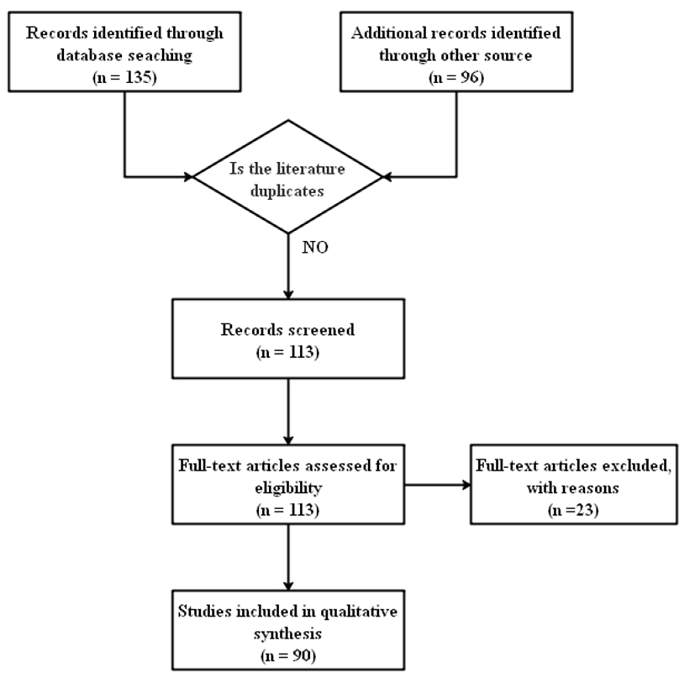
2. Research Methods
3. Analysis
3.1. Planning and Design
3.2. Construction
3.3. Operation and Maintenance
3.4. Information Exchange
4. Discussion and Future Work
4.1. Planning and Design
4.2. Construction
4.3. Operation and Maintenance
4.4. Information Exchange
5. Conclusions
Author Contributions
Funding
Institutional Review Board Statement
Informed Consent Statement
Conflicts of Interest
References
- Liu, W.P.; Guo, H.L.; Li, H.; Li, Y. Using BIM to Improve the Design and Construction of Bridge Projects: A Case Study of a Long-span Steel-box Arch Bridge Project. Int. J. Adv. Robot Syst. 2014, 11, 125. [Google Scholar] [CrossRef]
- Shim, C.S.; Yun, N.R.; Song, H.H. Application of 3D Bridge Information Modeling to Design and Construction of Bridges. Procedia Eng. 2011, 14, 95–99. [Google Scholar] [CrossRef]
- Lee, K.M.; Lee, Y.B.; Shim, C.S.; Park, K.L. Bridge information models for construction of a concrete box-girder bridge. Struct. Infrastruct. Eng. 2012, 8, 687–703. [Google Scholar] [CrossRef]
- Tanner, P.; Bellod, J.L.; Sanz, D. Paper and Pencil in the Age of BIM. Struct. Eng. Int. 2018, 28, 396–407. [Google Scholar] [CrossRef]
- Zagorskas, J.; Turskis, Z. Location Preferences of New Pedestrian Bridges Based on Multi-Criteria Decision-Making and GIS-Based Estimation. Balt. J. Road Bridge Eng. 2020, 15, 158–181. [Google Scholar] [CrossRef]
- Jaro, T.S.; Iguisi, M.P. Development of GIS-Based Road Transport Information Management System for Adamawa Central, Adamawa State, Nigeria. J. Inf. Eng. Appl. 2015, 5, 57–73. [Google Scholar]
- Fanning, B.; Clevenger, C.M.; Ozbek, M.E.; Mahmoud, H. Implementing BIM on Infrastructure: Comparison of Two Bridge Construction Projects. Pract. Period. Struct. Des. Constr. 2015, 20, 04014044. [Google Scholar] [CrossRef]
- Shim, C.S.; Lee, K.M.; Kang, L.S.; Hwang, J.; Kim, Y. Three-Dimensional Information Model-Based Bridge Engineering in Korea. Struct. Eng. Int. 2012, 22, 8–13. [Google Scholar] [CrossRef]
- Vilventhan, A.; Rajadurai, R. 4D Bridge Information Modelling for management of bridge projects: A case study from India. Built Environ. Proj. Asset Manag. 2020, 10, 423–435. [Google Scholar] [CrossRef]
- Sakdirat, K.; Jessada, S.; Zhihao, Z. Sustainability-Based Lifecycle Management for Bridge Infrastructure Using 6D BIM. Sustainability 2020, 12, 2436. [Google Scholar]
- Dang, N.S.; Rho, G.T.; Shim, C.S. A Master Digital Model for Suspension Bridges. Appl. Sci. 2020, 10, 7666. [Google Scholar] [CrossRef]
- Xiaochen, D.; Haixia, L.; Tianming, H.; Luhai, L.; Kai, W. Research on the 3D Nonlinear Intelligent Control for Bridge Engineering Operation and Maintenance Cost. J. Railw. Eng. Soc. 2020, 37, 102–107. [Google Scholar]
- Ford, M.; Kirkman, R.; Cox, J.; Ringeisen, D. Benefits of Geographic Information Systems in Managing a Major Transportation Program Evaluation and Lessons Learned. Transp. Res. Rec. J. Transp. Res. Board 2012, 2291, 1–7. [Google Scholar] [CrossRef]
- Yang, L.; Qian, Z. Design of urban bridge health monitoring system based on internet of things and gis. J. Geomat. 2019, 44, 19–22. [Google Scholar]
- Wan, C.; Zhou, Z.; Li, S.; Ding, Y.; Xu, Z.; Yang, Z.; Xia, Y.; Yin, F. Development of a Bridge Management System Based on the Building Information Modeling Technology. Sustainability 2019, 11, 4583. [Google Scholar] [CrossRef]
- Ren, G.; Ding, R.; Li, H. Building an ontological knowledgebase for bridge maintenance. Adv. Eng. Softw. 2019, 130, 24–40. [Google Scholar] [CrossRef]
- Changsu, S.; Hwirang, K.; Son, D.N.; Deokkeun, L. Development of BIM-based bridge maintenance system for cable-stayed bridges. Smart Struct. Syst. 2017, 20, 697–708. [Google Scholar]
- Hong, J.H.; Kuo, C.L. A semi-automatic lightweight ontology bridging for the semantic integration of cross-domain geospatial information. Int. J. Geogr. Inf. Sci. 2015, 29, 2223–2247. [Google Scholar] [CrossRef]
- Park, S.; Park, J.; Kim, B.G.; Lee, S.H. Improving Applicability for Information Model of an IFC-Based Steel Bridge in the Design Phase Using Functional Meanings of Bridge Components. Appl. Sci. 2018, 8, 2531. [Google Scholar] [CrossRef]
- Floros, G.S.; Boyes, G.; Owens, D.; Ellul, C. Developing ifc for infrastructure: A case study of three highway entities. ISPRS Ann. Photogramm. Remote Sens. Spat. Inf. Sci. 2019, IV-4, 59–66. [Google Scholar] [CrossRef]
- Mohamed, M.; Mohamed, H. A hybrid model for selecting location of mobile cranes in bridge construction projects. Balt. J. Road Bridge Eng. 2013, 8, 184–189. [Google Scholar]
- Chan, B.; Guan, H.; Hou, L.; Jo, J.; Blumenstein, M.; Wang, J. Defining a conceptual framework for the integration of modelling and advanced imaging for improving the reliability and efficiency of bridge assessments. J. Civ. Struct. Health 2016, 6, 703–714. [Google Scholar] [CrossRef]
- Kirsi, H.; Matti-Esko, J.; Pekka, P. Digitalization transforms the construction sector throughout asset’s life-cycle from design to operation and maintenance. Stahlbau 2017, 86, 340–345. [Google Scholar]
- O’Keeffe, A. The State of the Art of Bridge Information Modelling from Conceptual Design through to Operation. IJ3DIM 2014, 3, 29–39. [Google Scholar] [CrossRef]
- Costin, A.; Adibfar, A.; Hu, H.; Chen, S.S. Building Information Modeling (BIM) for transportation infrastructure-Literature review, applications, challenges, and recommendations. Automat. Constr. 2018, 94, 257–281. [Google Scholar] [CrossRef]
- Cheng, J.C.P.; Lu, Q.; Deng, Y. Analytical review and evaluation of civil information modeling. Automat. Constr. 2016, 67, 31–47. [Google Scholar] [CrossRef]
- Markiz, N.; Jrade, A. Integrating fuzzy-logic decision support with a bridge information management system (BrIMS) at the conceptual stage of bridge design. J. Inf. Technol. Constr. 2018, 23, 92–121. [Google Scholar]
- Markiz, N.; Jrade, A. Integrating a fuzzy-logic decision support system with bridge information modelling and cost estimation at conceptual design stage of concrete box-girder bridges. Int. J. Sustain. Built Environ. 2014, 3, 135–152. [Google Scholar] [CrossRef]
- Marzouk, M.; Hisham, M. Implementing earned value management using bridge information modeling. KSCE J. Civ. Eng. 2014, 18, 1302–1313. [Google Scholar] [CrossRef]
- Marzouk, M.; Hisham, M. Applications of Building Information Modeling in Cost Estimation of Infrastructure Bridges. IJ3DIM 2012, 1, 17–29. [Google Scholar] [CrossRef]
- Zou, Y.; Kiviniemi, A.; Jones, S.W.; Walsh, J. Risk Information Management for Bridges by Integrating Risk Breakdown Structure into 3D/4D BIM. KSCE J. Civ. Eng. 2019, 23, 467–480. [Google Scholar] [CrossRef]
- Zou, Y.; Kiviniemi, A.; Jones, S.W. Developing a tailored RBS linking to BIM for risk management of bridge projects. ECAM 2016, 23, 727–750. [Google Scholar] [CrossRef]
- Wang, Q.; Sohn, H.; Cheng, J.C.P. Automatic As-Built BIM Creation of Precast Concrete Bridge Deck Panels Using Laser Scan Data. J. Comput. Civ. Eng. 2018, 32, 04018011. [Google Scholar] [CrossRef]
- Xu, Y.; Turkan, Y. BrIM and UAS for bridge inspections and management. ECAM 2020, 27, 785–807. [Google Scholar] [CrossRef]
- Perry, B.J.; Guo, Y.; Atadero, R.; van de Lindt, J.W. Streamlined bridge inspection system utilizing unmanned aerial vehicles (UAVs) and machine learning. Measurement 2020, 164, 108048. [Google Scholar] [CrossRef]
- Jeong, S.; Hou, R.; Lynch, J.P.; Sohn, H.; Law, K.H. An information modeling framework for bridge monitoring. Adv. Eng. Softw. 2017, 114, 11–31. [Google Scholar] [CrossRef]
- Khaloo, A.; Lattanzi, D.; Cunningham, K.; Dell’Andrea, R.; Riley, M. Unmanned aerial vehicle inspection of the Placer River Trail Bridge through image-based 3D modelling. Struct. Infrastruct. Eng. 2018, 14, 124–136. [Google Scholar] [CrossRef]
- Odrobiňák, J.; Farbák, M.; Chromák, J.; Kortiš, J.; Gocál, J. Real Geometrical Imperfection of Bow-String Arches—Measurement and Global Analysis. Appl. Sci 2020, 10, 4530. [Google Scholar] [CrossRef]
- McGuire, B.; Atadero, R.; Clevenger, C.; Ozbek, M. Bridge Information Modeling for Inspection and Evaluation. J. Bridge Eng. 2016, 21, 1–9. [Google Scholar] [CrossRef]
- Nettis, A.; Saponaro, M.; Nanna, M. RPAS-Based Framework for Simplified Seismic Risk Assessment of Italian RC-Bridges. Buildings 2020, 10, 150. [Google Scholar] [CrossRef]
- Zixiao, Z.; Hesam, H.; Sarah, B.; Martin, F. 4D beyond construction: Spatio-temporal and life-cyclic modeling and visualization of infrastructure data. J. Inf. Technol. Constr. 2018, 23, 285–304. [Google Scholar]
- Kumar, P.A.; Phil, C. Infrastructure information management of bridges at local authorities in the UK. Infrastruct. Asset. Manag. 2018, 5, 120–131. [Google Scholar]
- Mawlana, M.; Vandatikhaki, F.; Doriani, A.; Hammad, A. Integrating 4D modeling and discrete event simulation for phasing evaluation of elevated urban highway reconstruction projects. Automat. Constr. 2015, 60, 25–38. [Google Scholar] [CrossRef]
- Dang, N.S.; Shim, C.S. BIM-based innovative bridge maintenance system using augmented reality technology. In CIGOS 2019, Innovation for Sustainable Infrastructure; Springer: Singapore, 2020; pp. 1217–1222. [Google Scholar]
- Boddupalli, C.; Sadhu, A.; Rezazadeh Azar, E.; Pattyson, S. Improved visualization of infrastructure monitoring data using building information modeling. Struct. Infrastruct. Eng. 2019, 15, 1247–1263. [Google Scholar] [CrossRef]
- Dang, N.S.; Shim, C.S. Bridge assessment for PSC girder bridge using digital twins model. In CIGOS 2019, Innovation for Sustainable Infrastructure; Springer: Singapore, 2020; pp. 1241–1246. [Google Scholar]
- Delgado, J.M.D.; Butler, L.; Brilakis, I.; Elshafie, M.; Middleton, C. Structural Performance Monitoring Using a Dynamic Data-Driven BIM Environment. J. Comput. Civ. Eng 2018, 32, 04018009. [Google Scholar] [CrossRef]
- Xia, Y. Research on dynamic data monitoring of steel structure building information using BIM. J. Eng. Des. Technol. 2020, 18, 1165–1173. [Google Scholar]
- Ma, S. Three-dimensional Laser Combined with BIM Technology for Building Modeling, Information Data Acquisition and Monitoring. Nonlinear Opt. Quantum Opt. 2020, 52, 191–203. [Google Scholar]
- Tu, Z. Research on Measuring Instrument of Bridge Building Bearing Capacity Based on Computer BIM Technology. J. Phys. Conf. Ser. 2020, 1574, 012110. [Google Scholar] [CrossRef]
- Almomani, H.; Almutairi, O.N. Life-cycle maintenance management strategies for bridges in kuwait. J. Environ. Treat. Tech. 2020, 8, 1556–1562. [Google Scholar]
- Yin, Z.H.; Li, Y.F.; Guo, J.; Li, Y. Integration Research and Design of the Bridge Maintenance Management System. Procedia Eng. 2011, 15, 5429–5434. [Google Scholar] [CrossRef]
- Kim, H.; Shen, Z.; Moon, H.; Ju, K.; Choi, W. Developing a 3D intelligent object model for the application of construction planning/simulation in a highway project. KSCE J. Civ. Eng. 2016, 20, 538–548. [Google Scholar] [CrossRef]
- Karaman, S.G.; Chen, S.S.; Ratnagaran, B.J. Three-Dimensional Parametric Data Exchange for Curved Steel Bridges. Transp. Res. Rec. J. Transp. Res. Board 2013, 2331, 27–34. [Google Scholar] [CrossRef]
- Sacks, R.; Ma, L.; Yosef, R.; Borrmann, A.; Daum, S.; Kattel, U. Semantic Enrichment for Building Information Modeling: Procedure for Compiling Inference Rules and Operators for Complex Geometry. J. Comput. Civ. Eng. 2017, 31, 04017062. [Google Scholar] [CrossRef]
- BIEŃ, J. Modelling of structure geometry in Bridge Management Systems. Arch. Civ. Mech. Eng. 2011, 11, 519–532. [Google Scholar] [CrossRef]
- Dušan, I.; Vladeta, S.; Matthias, T.; Rico, R.; Rade, H.; Jürgen, D. Bridge damage: Detection, IFC-based semantic enrichment and visualization. Automat. Constr. 2020, 112, 103088. [Google Scholar]
- Hüthwohl, P.; Brilakis, I.; Borrmann, A.; Sacks, R. Integrating RC Bridge Defect Information into BIM Models. J. Comput. Civ. Eng. 2018, 32, 04018013. [Google Scholar] [CrossRef]
- Davila Delgado, J.M.; Butler, L.J.; Gibbons, N.; Brilakis, I.; Elshafie, M.Z.; Middleton, C. Management of structural monitoring data of bridges using BIM. Bridge Eng. 2017, 170, 204–218. [Google Scholar] [CrossRef]
- Lee, J.H.; Park, J.J.; Yoon, H. Automatic Bridge Design Parameter Extraction for Scan-to-BIM. Appl. Sci. 2020, 10, 7346. [Google Scholar] [CrossRef]
- Sedek, M.; Serwa, A. Development of new system for detection of bridges construction defects using terrestrial laser remote sensing technology. Egypt. J. Remote Sens. Space Sci. 2016, 19, 273–283. [Google Scholar] [CrossRef][Green Version]
- McKenna, T.; Minehane, M.; O’Keeffe, B.; O’Sullivan, G.; Ruane, K. Bridge information modelling (BrIM) for a listed viaduct. Bridge Eng. 2017, 170, 192–203. [Google Scholar] [CrossRef]
- Ali, N.; Chen, S.S.; Srikonda, R.; Hu, H. Development of Concrete Bridge Data Schema for Interoperability. Transp. Res. Rec. J. Transp. Res. Board 2014, 2406, 87–97. [Google Scholar] [CrossRef]
- Abbas, R.; Ebrahim, K. Video to BrIM: Automated 3D As-Built Documentation of Bridges. J. Perform. Constr. Facil. 2018, 32, 04018026. [Google Scholar]
- Lu, R.; Brilakis, I. Digital twinning of existing reinforced concrete bridges from labelled point clusters. Automat. Constr. 2019, 105, 102837. [Google Scholar] [CrossRef]
- Ziboon, A.R.T.; Qasim, Z.I.; Falih, K.T. Gis application to evaluate transportations network in nasiriyah city. J. Eng. Sustain. Dev. 2017, 21, 75–87. [Google Scholar]
- Almumaiz, M.O. Improvement of Transportation Network of Al-Muwaffaqiyah Town Using Gis. J. Eng. Dev. 2014, 18, 229–245. [Google Scholar]
- Liu, Y.L.; Xu, K.H. GIS for Highway Engineering Bearing Capacity Evaluation. J. Highw. Transp. Res. Dev. 2014, 8, 28–33. [Google Scholar] [CrossRef]
- Ardeshir, A.; Mohseni, N.; Behzadian, K.; Errington, M. Selection of a Bridge Construction Site Using Fuzzy Analytical Hierarchy Process in Geographic Information System. Arab. J. Sci. Eng. 2014, 39, 4405–4420. [Google Scholar] [CrossRef]
- Hojune, A.; Youngjin, C.; Hyuk, L.J.; Ik, J.Y.; Sik, K.J. Semiquantitative Fire Risk Grade Model and Response Plans on a National Highway Bridge. Adv. Civ. Eng. 2019, 2019, 1–13. [Google Scholar]
- Bernier, C.; Gidaris, I.; Balomenos, G.P.; Padgett, J.E. Assessing the Accessibility of Petrochemical Facilities during Storm Surge Events. Reliab. Eng. Syst. Safe 2019, 188, 155–167. [Google Scholar] [CrossRef]
- Mingfeng, H.; Yifan, W. Multi-scale simulation of time-varying wind fields for Hangzhou Jiubao Bridge during Typhoon Chan-hom. J. Wind. Eng. Ind. Aerod. 2018, 179, 419–437. [Google Scholar]
- Kappos, A.; Sextos, A.; Stefanidou, S.; Mylonakis, G.; Pitsiava, M.; Sergiadis, M. Seismic Risk of Inter-urban Transportation Networks. Procedia Econ. Financ. 2014, 18, 263–270. [Google Scholar] [CrossRef]
- Aydin, S.G.; Shen, G.; Pulat, P. A Retro-Analysis of I-40 Bridge Collapse on Freight Movement in the U.S. Highway Network using GIS and Assignment Models. Int. J. Transp. Sci. Technol. 2012, 1, 379–397. [Google Scholar] [CrossRef]
- Twumasi-Boakye, R.; Sobanjo, J.O. Resilience of Regional Transportation Networks Subjected to Hazard-Induced Bridge Damages. J. Transp. Eng. 2018, 144, 04018062. [Google Scholar] [CrossRef]
- Lethanh, N.; Adey, B.T.; Burkhalter, M. Determining an Optimal Set of Work Zones on Large Infrastructure Networks in a GIS Framework. J. Infrastruct. Syst. 2018, 24, 04017048. [Google Scholar] [CrossRef]
- Tsai, M.K.; Yau, N.J. Using mobile disaster response system in bridge management. J. Civ. Eng. Manag. 2014, 20, 737–745. [Google Scholar] [CrossRef]
- Al-Aamri, A.K.; Hornby, G.; Zhang, L.C.; Al-Maniri, A.A.; Padmadas, S.S. Mapping road traffic crash hotspots using GIS-based methods: A case study of Muscat Governorate in the Sultanate of Oman. Spat. Stat. 2021, 42, 100458. [Google Scholar] [CrossRef]
- Javadnejad, F.; Gillins, D.T.; Higgins, C.C.; Gillins, M.N. BridgeDex: Proposed Web GIS Platform for Managing and Interrogating Multiyear and Multiscale Bridge-Inspection Images. J. Comput. Civ. Eng 2017, 31, 04017061. [Google Scholar] [CrossRef]
- Liu, T.; Pan, Q.; Sanchez, J.; Sun, S.; Wang, N.; Yu, H. Prototype Decision Support System for Black Ice Detection and Road Closure Control. IEEE Intell. Transp. Syst. Mag. 2017, 9, 91–102. [Google Scholar] [CrossRef]
- Mehta, G.; Li, J.; Fields, R.T.; Lou, Y.; Jones, S. Safety Performance Function Development for Analysis of Bridges. J. Transp. Eng. 2015, 141, 04015010. [Google Scholar] [CrossRef]
- Contreras-Nieto, C.; Shan, Y.; Lewis, P.; Hartell, J.A. Bridge maintenance prioritization using analytic hierarchy process and fusion tables. Automat. Constr. 2019, 101, 99–110. [Google Scholar] [CrossRef]
- Shields, G.M. Resiliency Planning: Prioritizing the Vulnerability of Coastal Bridges to Flooding and Scour. Procedia Eng. 2016, 145, 340–347. [Google Scholar] [CrossRef]
- Yoon, S.; Kim, J.; Kim, M.; Tak, H.Y.; Lee, Y.J. Accelerated System-Level Seismic Risk Assessment of Bridge Transportation Networks through Artificial Neural Network-Based Surrogate Model. Appl. Sci 2020, 10, 6476. [Google Scholar] [CrossRef]
- Wattan, S.A.A.; Al-Bakri, M. Development of Bridges Maintenance Management System based on Geographic Information System Techniques. J. Eng. 2019, 25, 232. [Google Scholar] [CrossRef]
- Weber, J. Route change on the American freeway system. J. Transp. Geogr. 2018, 67, 12–23. [Google Scholar] [CrossRef]
- Dabous, S.A.; Yaghi, S.; Alkass, S.; Moselhi, O. Concrete bridge deck condition assessment using IR Thermography and Ground Penetrating Radar technologies. Automat. Constr. 2017, 81, 340–354. [Google Scholar] [CrossRef]
- Vaghefi, K.; Ahlborn, T.M.; Harris, D.K.; Brooks, C.N. Combined Imaging Technologies for Concrete Bridge Deck Condition Assessment. J. Perform. Constr. Facil. 2015, 29, 04014102. [Google Scholar] [CrossRef]
- Fisher, R.; Heckbert, S.; Villalobos, J.M.L.; Sutton, S. Augmenting physical 3D models with projected information to support environmental knowledge exchange. Appl. Geogr. 2019, 112, 102095. [Google Scholar] [CrossRef]
- Junxiang, Z.; Xiangyu, W.; Peng, W.; Zhiyou, W.; Mi Jeong, K. Integration of BIM and GIS: Geometry from IFC to shapefile using open-source technology. Automat. Constr. 2019, 102, 105–119. [Google Scholar]
- Chong, H.Y.; Lopez, R.; Wang, J.; Wang, X.; Zhao, Z. Comparative analysis on the adoption and use of BIM in road infrastructure projects. J. Manag. Eng. 2016, 32, 05016021. [Google Scholar] [CrossRef]
- Wang, J.; Sun, W.; Shou, W.; Wang, X.; Wu, C.; Chong, H.Y.; Liu, Y.; Sun, C. Integrating BIM and LiDAR for real-time construction quality control. J. Intel. Robot. Syst. 2015, 79, 417–432. [Google Scholar] [CrossRef]
- Zhu, J.; Wright, G.; Wang, J.; Wang, X. A critical review of the integration of geographic information system and building information modelling at the data level. ISPRS Int. J. Geo-Inform. 2018, 7, 66. [Google Scholar] [CrossRef]
- Xu, S.; Wang, J.; Shou, W.; Ngo, T.; Sadick, A.M.; Wang, X. Computer vision techniques in construction: A critical review. Arch. Comput. Methods Eng. 2020, 1–15. [Google Scholar] [CrossRef]
- Tsai, Y.H.; Wang, J.; Chien, W.T.; Wei, C.Y.; Wang, X.; Hsieh, S.H. A BIM-based approach for predicting corrosion under insulation. Automat. Constr. 2019, 107, 102923. [Google Scholar] [CrossRef]


| Journals | Sum | 2011 | 2012 | 2013 | 2014 | 2015 | 2016 | 2017 | 2018 | 2019 | 2020 |
|---|---|---|---|---|---|---|---|---|---|---|---|
| AIC | 8 | 1 | 1 | 1 | 1 | 3 | 1 | ||||
| JCCE | 5 | 2 | 3 | ||||||||
| AS | 5 | 1 | 4 | ||||||||
| SIE | 3 | 1 | 1 | 1 | |||||||
| KSCE JCE | 3 | 1 | 1 | 1 | |||||||
| TRR JTRB | 3 | 1 | 1 | 1 | |||||||
| PE | 3 | 2 | 1 | ||||||||
| AES | 2 | 1 | 1 | ||||||||
| Sustainability | 2 | 1 | 1 | ||||||||
| JPCF | 2 | 1 | 1 | ||||||||
| ECAM | 2 | 1 | 1 | ||||||||
| SEI | 2 | 1 | 1 | ||||||||
| BJRBE | 2 | 1 | 1 | ||||||||
| JTE | 2 | 1 | 1 | ||||||||
| BE | 2 | 2 | |||||||||
| ITcon | 2 | 2 | |||||||||
| LNCE | 2 | 2 | |||||||||
| IJ3DIM | 2 | 1 | 1 | ||||||||
| RESS | 1 | 1 | |||||||||
| Measurement | 1 | 1 | |||||||||
| ACME | 1 | 1 | |||||||||
| JWEIA | 1 | 1 | |||||||||
| IJGIS | 1 | 1 | |||||||||
| SSS | 1 | 1 | |||||||||
| JCSHM | 1 | 1 | |||||||||
| JBE | 1 | 1 | |||||||||
| IEEE ITSM | 1 | 1 | |||||||||
| JCEM | 1 | 1 | |||||||||
| Stahlbau | 1 | 1 | |||||||||
| IJARS | 1 | 1 | |||||||||
| ACE | 1 | 1 | |||||||||
| AJSE | 1 | 1 | |||||||||
| PPSDC | 1 | 1 | |||||||||
| BEPAM | 1 | 1 | |||||||||
| JOE | 1 | 1 | |||||||||
| EJRSSS | 1 | 1 | |||||||||
| IJSBE | 1 | 1 | |||||||||
| PEF | 1 | 1 | |||||||||
| JHTRD | 1 | 1 | |||||||||
| IAM | 1 | 1 | |||||||||
| ISPRS APRSSI | 1 | 1 | |||||||||
| JIEA | 1 | 1 | |||||||||
| JED | 1 | 1 | |||||||||
| Buildings | 1 | 1 | |||||||||
| JRES | 1 | 1 | |||||||||
| JEDT | 1 | 1 | |||||||||
| JETT | 1 | 1 | |||||||||
| JPCS | 1 | 1 | |||||||||
| NOQO | 1 | 1 | |||||||||
| SS | 1 | 1 | |||||||||
| JG | 1 | 1 | |||||||||
| AG | 1 | 1 | |||||||||
| JIS | 1 | 1 | |||||||||
| JTG | 1 | 1 | |||||||||
| JESD | 1 | 1 | |||||||||
| Sum | 90 | 3 | 5 | 2 | 10 | 6 | 7 | 10 | 15 | 13 | 19 |
| BIM and GIS | 2 | 2 | |||||||||
| BIM | 58 | 2 | 3 | 2 | 5 | 2 | 6 | 6 | 11 | 5 | 16 |
| GIS | 30 | 1 | 2 | 5 | 4 | 1 | 4 | 4 | 6 | 3 | |
| Sum | 90 | 3 | 5 | 2 | 10 | 6 | 7 | 10 | 15 | 13 | 19 |
| Technology | Planning and Design | Construction | Operation and Maintenance | Information Exchange |
|---|---|---|---|---|
| BIM | [1,2,3,4,8,11,23,27] | [1,2,3,7,8,9,10,11,21,28,29,30,31,32,33,34,35] | [12,16,17,34,36,37,38,39,40,41,42,43,44,45,46,47,48,49,50,51,52] | [11,19,20,22,36,41,44,46,53,54,55,56,57,58,59,60,61,62,63,64,65] |
| GIS | [5,6,66,67,68] | [69] | [13,14,70,71,72,73,74,75,76,77,78,79,80,81,82,83,84,85,86] | [18,77,87,88,89] |
| BIM and GIS | [15] | [15,90] |
| Examples | Application Type | Key Outcome | Limitations |
|---|---|---|---|
| Technology: BIM | |||
| [1] | Error/clash detection |
|
|
| [2] | Parametric modeling |
|
|
| [3,8] | Parametric modeling, simulation, visualization |
|
|
| [4] | Aesthetic |
|
|
| [11] | Design model integration |
|
|
| [23] | Visualization |
|
|
| [27] | Parametric analysis |
|
|
| [28] | Conceptually plan |
|
|
| Technology: GIS | |||
| [5] | Bridge location |
|
|
| [6,66] | Road transport information management system |
|
|
| [67] | Transportation network |
|
|
| [68] | Evaluation |
|
|
| Examples | Application Type | Key Outcome | Limitations |
|---|---|---|---|
| Technology: BIM | |||
| [1] | Construction schedule |
|
|
| [2] | Produce shop drawing |
|
|
| [3] | Construction schedule |
|
|
| [7] | Construction schedule, rework |
|
|
| [8] | Risk factor |
|
|
| [9] | Construction sequence, schedule |
|
|
| [10] | Rework |
|
|
| [21] | Crane location |
|
|
| [29] | Budget, schedule |
|
|
| [30] | Cost estimate, review estimate |
|
|
| [31,32] | Risk location |
|
|
| [33,34,35] | Estimate dimension |
|
|
| [53,54] | Earth filling |
|
|
| Technology: GIS | |||
| [69] | Bridge construction site |
|
|
| Examples | Application Type | Key Outcome | Limitations |
|---|---|---|---|
| Technology: BIM | |||
| [12] | Operation and maintenance cost |
|
|
| [16] | Automatic rule checking |
|
|
| [17,36] | Operation and maintenance cost |
|
|
| [34,37,38] | 3D in situ modelling |
|
|
| [39,40] | Bridge evaluation |
|
|
| [41,42] | Maintenance scheduling |
|
|
| [43] | Bridge evaluation |
|
|
| [44] | Bridge inspection |
|
|
| [45] | Bridge evaluation |
|
|
| [46] | React to unexpected situation |
|
|
| [47] | Bridge monitoring |
|
|
| [48,49] | Bridge monitoring |
|
|
| [50] | Imaging processing |
|
|
| [51] | Bridge Management System (BMS) |
|
|
| Technology: GIS | |||
| [13,74] | Benefit-cost |
|
|
| [14,78] | Disaster response system |
|
|
| [70] | Fire alarm time |
|
|
| [71,72] | Bridge evaluation |
|
|
| [73] | Bridge evaluation |
|
|
| [75] | Bridge evaluation |
|
|
| [76] | BMD |
|
|
| [77] | Disaster response system |
|
|
| [79] | BMS |
|
|
| [80] | Bridge Maintenance Decision (BMD) |
|
|
| [81] | Bridge inspection |
|
|
| [82,83] | BMD |
|
|
| [52] | BMS |
|
|
| [84] | Bridge evaluation |
|
|
| [85] | BMS |
|
|
| [86] | BMD |
|
|
| Technology: BIM and GIS | |||
| [15] | BMS |
|
|
| Examples | Application Type | Key Outcome | Limitations |
|---|---|---|---|
| Technology: BIM | |||
| [11] | Interoperability |
|
|
| [19] | IFC standard |
|
|
| [20] | IFC expansion |
|
|
| [22,60,61,62,64,65] | Interoperability |
|
|
| [36,44,59] | Storage, sharing, utilization |
|
|
| [41] | Data integration |
|
|
| [46] | Interoperability |
|
|
| [55] | Expand standard |
|
|
| [56] | Expand standard |
|
|
| [57,58] | Data integration |
|
|
| [63] | Interoperability |
|
|
| Technology: GIS | |||
| [18] | Data integration |
|
|
| [87,88] | Data integration |
|
|
| [89] | Interoperability |
|
|
| Technology: BIM and GIS | |||
| [15] | IFC expansion |
|
|
| [90] | Interoperability, data integration |
|
|
| Application Aspects | Contents | Challenge | Potential Solution |
|---|---|---|---|
| Planning and design | Planning: Plan roads (bridges), find bridge site. Design: Establish bridge 3D information design model. |
|
|
| Construction | Cost, schedule. |
|
|
| Operation and maintenance | Bridge traffic network, bridge management system, bridge inspection, bridge evaluation, bridge maintenance decision. |
|
|
| Information exchange | Expand standard, data integration, interoperability. |
|
|
Publisher’s Note: MDPI stays neutral with regard to jurisdictional claims in published maps and institutional affiliations. |
© 2021 by the authors. Licensee MDPI, Basel, Switzerland. This article is an open access article distributed under the terms and conditions of the Creative Commons Attribution (CC BY) license (https://creativecommons.org/licenses/by/4.0/).
Share and Cite
Wei, J.; Chen, G.; Huang, J.; Xu, L.; Yang, Y.; Wang, J.; Sadick, A.-M. BIM and GIS Applications in Bridge Projects: A Critical Review. Appl. Sci. 2021, 11, 6207. https://doi.org/10.3390/app11136207
Wei J, Chen G, Huang J, Xu L, Yang Y, Wang J, Sadick A-M. BIM and GIS Applications in Bridge Projects: A Critical Review. Applied Sciences. 2021; 11(13):6207. https://doi.org/10.3390/app11136207
Chicago/Turabian StyleWei, Jiangang, Gang Chen, Jizhuo Huang, Li Xu, Yan Yang, Jun Wang, and Abdul-Manan Sadick. 2021. "BIM and GIS Applications in Bridge Projects: A Critical Review" Applied Sciences 11, no. 13: 6207. https://doi.org/10.3390/app11136207
APA StyleWei, J., Chen, G., Huang, J., Xu, L., Yang, Y., Wang, J., & Sadick, A.-M. (2021). BIM and GIS Applications in Bridge Projects: A Critical Review. Applied Sciences, 11(13), 6207. https://doi.org/10.3390/app11136207