Article

Spatial Variations in Microbial Compositions in a Karst Critical Zone in Samcheok, Republic of Korea

Department of Geology, Kangwon National University, Chuncheon 24341, Korea
*
Author to whom correspondence should be addressed.
Appl. Sci. 2020, 10(14), 4714; https://doi.org/10.3390/app10144714
Submission received: 16 June 2020 / Revised: 6 July 2020 / Accepted: 6 July 2020 / Published: 8 July 2020
(This article belongs to the Special Issue Advances in Geohydrology: Methods and Applications)

Abstract

:
The effects of the unpredictability of the flow system in a karst area, with respect to bacterial communities in the aquatic environment, were evaluated. Bacterial communities from two different types of flow conditions (spring and sinkhole) were characterized and compared in the karst area. Proteobacteria, Bacteroidetes, and Verrucomicrobia were the major phyla present in the sampled spring and sinkhole waters. The water samples from the spring points were heavily loaded with Actinobacteria, especially Firmicutes, which accounted for 4.3% of the bacterial content. Furthermore, Actinobacteria were prevalent in some water samples, serving as indicators of the effects of seawater inundation. The richness and diversity of bacterial species were evaluated at the spring and sinkhole water points. The spring waters showed a higher bacterial richness and diversity compared to the sinkhole waters. Our results provide valuable information for the evaluation and investigation of microbial compositions in karst areas, which are characterized by heterogeneous hydrological conditions. The microbial species in karst areas are already exposed to changing hydrogeological conditions, and are likely to be confronted with future changes; thus, their spatiotemporal variations reflect the shifting baselines of physicochemical and ecosystem processes.

1. Introduction

Karst regions contain abundant exposures of limestone or dolomite above the erosion surface, and a well-developed groundwater system formed by the erosion of these rock bodies. A variety of distinctive karst landforms occur both on the ground surface and underground. The term karst was originally used for the limestone regions of Slovenia and Croatia in the former Yugoslavia, and it referred to desert land covered with rocks. Owing to the geological characteristics and excellent underground conduit development in limestone regions, underground seepage of rainwater is rapid, and groundwater recharge is remarkably high [1]. In addition, a karst terrain exhibits unique geological features, and has a significant effect on the water quality of rivers and groundwater due to water–rock interactions [2] (Figure 1).
Carbonate regions account for approximately 20% of the Earth’s surface [3], and many of these regions utilize groundwater for daily water supply [4]. Therefore, it is crucial to protect the quality and supply of groundwater in these regions. Previous research has analyzed the hydrological characteristics and flow patterns of groundwater in carbonate regions [5,6]. These characteristics are also observed in some limestone regions of Gangwon-do (Samcheok, Yeongwol, Jeongseon and Sokcho) and the northern parts of Chungcheongbuk-do (Danyang-gun) in Korea. In the carbonate areas of Korea, groundwater is used for both agricultural purposes and daily use, prompting numerous primary investigations and impact survey reports [7]. However, academic research on the hydro-ecological characteristics of the karst regions in Korea, focusing on their hydrological, hydrogeological and flow characteristics, has been minimal.
Prominent features of karst hydrogeology include difficulty in identifying flow paths and variable fluctuations in flow rates [8,9,10]. Furthermore, the hydrologic properties and flow patterns of groundwater and surface water in the carbonate regions have not yet been clearly identified, due to the heterogeneous and complex petrological properties of carbonate rocks [11,12,13,14,15,16]. Therefore, it is difficult to evaluate, predict and manage groundwater flow and pollutant movement in these regions. As such, climate change, hydrogeology, water resource management and human impacts are all key research areas for karst landscapes.
The United Nations Educational, Scientific and Cultural Organization (UNESCO) International Geoscience Program (IGCP) has been promoted by the International Union of Geological Sciences (IUGS) since 1972. The program conducts international research in five areas, namely, groundwater, climate change, geodynamics, geological resources and geological disasters. Recently, the IGCP 661 has formed an international collaborative research team to conduct a global comparative project regarding the structure, material circulation and environmental sustainability in key areas of the karst systems. To date, IGCP 661 has analyzed the influence of the geological structure, and the impact of climate and vegetation differentiation, on the type of critical zone. It has also analyzed the hydrogeological structure and characteristics of, the biogeochemical process in, and the effect of microbial action on, the material cycle of the critical zone. Additionally, it has evaluated the water ecological and carbon uptake functions, as well as the impact factors, record index, and mechanisms for maintaining critical zones, and has established monitoring stations and standards for several key karst regions across the world [17,18,19,20,21,22].
The International Association of Hydrological Sciences (IAH), founded in 1971 and consisting of 4500 members from 81 countries around the world, formed the IAH Commission on Karst Hydrology to actively engage in research activity and exchange [23,24,25,26,27,28]. The IAH Commission promotes the development of scientific foundations and management technologies for the management and protection of water resources in karst regions, to ensure the reliable supply of drinking and agricultural water. Participants include eminent hydrogeologists from countries with karst terrains, such as China, the United States, Canada and European countries, and promote active research exchange through annual research seminars and workshops.
However, relatively little research has been conducted on the water chemistry of groundwater and river water in limestone areas; specifically, studies on the microbial communities inhabiting karst water environments are scarce [29]. Therefore, as these regions have a substantial influence on water quality and microbial community composition due to the geological properties of carbonate rocks, basic analyses of river–groundwater–microbial community interactions and biogeochemical processes are required in order to ensure the reliability of water resources in karst regions. Such research should include integrated hydrogeological and hydro-ecological studies.
In this study, we evaluate the chemistry of the river water around the Sohangul aquifer spring in Samcheok City, and the effects of regional variations in the surface water hydrogeological characteristics on the microbial community. The specific aims of this study are: (1) to characterize the diversity of the bacterial community in the stream waters at the sink and spring points of the karst area through pyrosequencing analysis; and (2) to correlate the microbial diversity with the hydrogeological and physiochemical properties of the stream waters in this karst area.

2. Materials and Methods

2.1. Study Area

2.1.1. Geology

Carbonate regions in Korea account for approximately 6% of the Korean Peninsula and are divided into the Choseon supergroup of the early Paleozoic (Cambrian–Ordovician) and the coastal supergroup of the late Paleozoic (Carboniferous and Permian periods) [30,31,32]. The Precambrian Taebaeksan series forms the bedrock in the study area, and it is unconformably overlain by the great Paleozoic limestone series, which is in turn unconformably covered by young fluvial deposits [33]. The Taebaeksan series is distributed in a north-south direction in the eastern lowlands of the study area. The bedrock is predominantly schist due to regional metamorphism, but secondary gneissic action has led to the emplacement of gneisses distributed over the schist [34]. The Jangsan Quartzite Formation unconformably covers the Taebaeksan series and it is distributed in a north-south direction. The thickness of the formation ranges from 10 to 50 m and varies greatly depending on the region. It is predominantly composed of quartzite; however, a basin is found within 10 m of the base that consists of quartzite, granite and slate with very high roundness. The Myobong Formation, which is conformable with the Jangsan Quartzite Formation, is distributed in a north-south direction on the left side of the Jangsan Quartzite Formation with a thickness of 100–250 m [33]. The Myobong Formation is a clastic sedimentary deposit composed of dark gray shale and slate in the lower part and quartzite and lenticular limestone in the middle part. The Pungchon limestone formation is conformable with the Myobong Formation, and it is widely distributed in a north-south direction in the central region of the study area (Figure 2).
Pungchon limestone comprises dolomite and rose pink, white, and gray limestone, with more shale coexisting toward the top of the formation [35,36]. The Hwajeol Formation, which is conformable with the Pungchon limestone, is the uppermost layer of the Paleozoic Cambrian. It is distributed in a north-south direction to the west of the Pungchon limestone formation. The lower part of the Hwajeol Formation is composed of dark brown or dark green shale and slate, whereas the upper part is heterogeneous limestone. The Dongjeom quartzite formation is conformable with the Hwajeol Formation and belongs to the early Ordovician Period of the Paleozoic. It is distributed over a small region in a north-south direction to the west of the study area.

2.1.2. Hydrogeology

Samcheok City has an area of 1184.8 km2 and a population density of 60.3 persons/km2 (Samcheok City, 2020). In Samcheok City, 7,418,510 m3 of groundwater, from 2201 wells, is used annually. Of this amount, 3,076,220 m3 (41.47%) is used for living, 2,903,970 m3 (39.14%) for agriculture and fisheries, 1,427,860 m3 (19.25%) for industrial use, and 10,460 m3 is for other uses (0.14%) [7]. The annual mean groundwater recharge rate for the study area was calculated using the NRCS–CN (Natural Resources Conservation Service–Curve Number) method at 13.31%, and the groundwater development capacity is estimated at 148,024,000 m3/year, which is 10.15% of the total water resources (1,458,617,500 m3/year). Groundwater use per unit area is 6261.40 m3/year/km2, and the density of groundwater facility development is 1.86 locations/km2 [7]. The groundwater recharge area in Samcheok City is 891.05 km2 (65.3%), the transit area is 290.83 km2 (21.3%), and the discharge area is 183.30 km2 (13.4%) [7].
There are 13 local streams in the Samcheok area [7]. The mean transmissivity values per hydrogeological unit in the Samcheok area are 8.73 m2/day, 7.10 m2/day, 1.57 m2/day, 6.80 m2/day, 1.90 m2/day, 5.61 m2/day and 2.64 m2/day for unconsolidated clastic deposits, semi-consolidated clastic sedimentary rocks, intrusive igneous rocks, non-porous volcanic rocks, clastic sedimentary rocks, carbonate rocks and metamorphic rocks, respectively. The corresponding mean hydraulic conductivity values are 0.1890 m/day, 0.0982 m/day, 0.0442 m/day, 0.1011 m/day, 0.0276 m/day, 0.1487 m/day and 0.1054 m/day, respectively [7]. Among the seven hydrogeological units mentioned above, metamorphic rocks and carbonate rocks account for 65% of the total area.
The rivers in the study area are characterized by abundant water flowing upstream of the Cheonggyecheon River; however, all of the water seeps into the ground in the vicinity of Hawolsan, leaving only gravel occupying the riverbed with no stream flow (Figure 3). The stream is therefore a dry valley in which water flows only when it rains. Approximately 1 km downstream, water starts to emerge gradually and overland flow resumes. However, the flow amount is relatively small compared to the amount of water that seeped into the ground upstream. In addition, the study area includes a limestone cave called Sohangul, located in Geundeok-myeon, Samcheok City, which discharges the largest amount of groundwater in Korea. The measured flow rate of groundwater discharged from Sohangul spring to the stream is 28,477.4 m2/day [7].
From 2000 to 2019, the average annual precipitation for the period was 1302 mm. The maximum annual precipitation from 2000 to 2019 was 2000 mm in 2006, and the minimum was 900 mm in 2015 (Figure 4). In addition, precipitation has generally decreased over the years (see declining trendline). The precipitation data for the past two decades indicates that more than 60–70% of the total annual precipitation occurs in the wet season due to the monsoon weather, which is characteristic of the climate of the Korean Peninsula [37,38]. The annual average air temperature has demonstrated a general increase from 2000 to 2019.

2.2. Water Sampling and Chemical Analysis

The water sampling points are shown in Figure 5. The 9 stream water sampling sites are classified according to stream water quantities. Five points (HMS1, HMS2, HMS8, HMS11 and HMS14) were located in the stream channels that have 50–100% of the stream water, and four points (KGS1, SJS1, SJS4 and YSS3) were located in the stream channels that have 0–50% of the stream water. The water samples (3 L) for microbe analysis were filtered using a 0.25-µm pore filter. Water samples (100 mL each) were transferred to acid-washed polypropylene bottles for chemical analysis of cations and anions after filtering through 0.45-μm polyethersulfone (PES) filters (SP13P045SL, Hyundai Micro., Ltd., Seoul, Korea). Water temperature, pH, dissolved oxygen (DO), oxidation-reduction potential (ORP) and electrical conductivity (EC) of the groundwater and stream water were measured in the field using a portable meter (HORIBA, Ltd., Anyang-Si, Korea).
Alkalinity, expressed as bicarbonate, was quantified with a digital auto-titrator with 0.05 N HCl and methyl orange as an indicator. Sodium, potassium, calcium, magnesium and silica concentrations were determined using inductively coupled plasma–optical emission spectrometry (ICP–OES/iCAP 6500 Duo; SPECTRO, Mahwah, NJ, USA), and sulfate, chloride and nitrate concentrations were determined using ion chromatography (761 Compact IC, Metrohm AG, Herisau, Switzerland) at the Analytical Centre for Science Research of the Sangji University in Wonju, Korea. The stable isotope values of δ18O and δD in groundwater were analyzed using an isotope ratio mass spectrometer (IRMS, Miami, FL, USA) or cavity ring-down spectrometer (CRDS, Miami, FL, USA) at Beta Analytic Testing Laboratory. The analyzed values are denoted by δ-values relative to the Vienna Standard Mean Ocean Water value. The accuracies for the δ18O and δD values are 0.1% and 1%, respectively [39,40].

2.3. DNA Extraction, PCR and Pyrosequencing Analysis

The water samples (3 L/each) for microbial analysis were filtered through 0.25-µm size filter and returned to the laboratory and stored at −80 °C in a refrigerator until DeoxyriboNucleic Acid (DNA) extraction and pyrosequencing of 16S Ribosomal Ribonucleic Acid (rRNA) analysis were carried out. The DNA of the sampled water was extracted using a FastDNA Spin Kit (Qbiogene, Carlsbad, CA, USA) as specified by the manufacturer. The quality of the extracted DNA was checked by standard agarose gel electrophoresis, and stored at −20 °C. The DNA concentration was determined using a UV–VIS Spectrophotometer (Mechasys Co. Ltd., Siheung-si, Korea). The 16S rRNA was also amplified by Polymerase Chain Reaction (PCR) for multiplexed pyrosequencing using barcoded primers. To analyze the taxonomic composition of the water bacteria community, the V1–V3 region of the 16S rRNA gene was chosen for the amplification and subsequent pyrosequencing of the PCR products at the ChunLab Inc. (Seoul, Korea) [41,42]. The 16S rRNA genes were amplified using forward and inverse primers to distinguish each sample prior to sequencing at the ChunLab Inc. [39,43]. Pyrosequencing was conducted using 454 Genome Sequencer FLX Titanium Junior (Roche, Branchburg, NJ, USA) by the ChunLab Inc. (Seoul, Korea). Distinct sequences were deposited in the Sequence Read Archive (ChunLab Inc.).

2.4. Pyrosequencing Data Processing and Statistical Analysis

The sequencing reads from the 9 samples were separated by unique barcodes. The sequences of the barcodes, PCR primers and linkers were then removed from each side of the original sequencing reads. Sequential bioinformatics analysis was performed to filter out high quality reads of the sequences generated by pyrosequencing. Chimeras were identified using the UCHIME algorithm [44] and removed. The raw reads were first demultiplexed and quality trimmed using the mothur software [45,46]. Bacterial community structures were analyzed using operational taxonomic units (OTUs). To calculate species diversity and richness within individual samples, alpha diversity analysis was conducted, including the computation of Abundance-based Coverage Estimator (ACE), Chao1 richness estimator, and the Shannon and Simpson diversity indices. Each sequence was identified by comparing it with the sequences in the EzTaxon-extended database (ChunLab Inc., http://eztaxon-e.ezbiocloud.net/) using BLASTN searches and pairwise similarity comparisons.
Furthermore, the frequently used Unweighted Pair Group Method with Arithmetic mean (UPGMA) tree, a hierarchical method that produces dendrograms with maximum cophenetic correlation, was the most efficient at representing the similarity between the evaluated genotypes [47,48]. To measure the similarity among communities, beta diversity was calculated, and 3D principal coordinate analysis (PCoA) plots were constructed.

3. Results and Discussion

3.1. Water Characteristics

The hydrogeochemical parameters, such as temperature, pH, electrical conductivity (EC), dissolved oxygen (DO), oxidation-reduction potential (ORP), turbidity, Ca2+, Mg2+, Na+, K+, HCO3, SO42−, Cl and NO3, were measured in the collected sink and spring waters from Hamaengbang (n = 5), Kyogok (n = 1), Yeosam (n = 1) and Sajik (n = 2) (Table 1). In this study, there are several potential sources or formation mechanisms for the Ca–Mg–HCO3, Ca–Mg–SO4 and Ca–Mg–Cl in the waters from the sinkhole and spring points. Characterization of the reflected hydrogeological characteristics of the karst area using Piper diagrams shows that the overall chemical character falls within the normal alkaline earth water group, indicating a predominantly Ca–Mg–HCO3 water type (Figure 6). The chemical composition of the water is partly attributed to the dissolution of silicate minerals in the bedrock, and aluminosilicates in the weathered regolith. The occurrence of Ca–Mg–SO4 in the study area is very unlikely to be attributed to the hydrogeological characteristics of the karst area, and it is probably effected by anthropogenic activities. Therefore, further studies are required to understand the possible evolution of this water type, especially in the case where the Ca–Mg–HCO3 type of water in the groundwater of the recharge area changes to the Ca–Mg–SO4 type along the direction of the water recharge points. The SJS sampling points, representing the recharge water within the residential areas of the study area, display higher major ion concentrations of SO4 and Cl than were found in the spring waters. Besides this, the KGS point is located adjacent to the limestone mine. This increase in SO4 and Cl is effected by anthropogenic activities, implying that the recharge area is directly affected by pollutants from the surface [6]. Therefore, attention should be paid to water quality management in the recharge area of the karst area.
Major ion chemistry of the stream water is an important tool for determining solute sources, and for describing water evolution as a result of water–rock interaction that leads to the dissolution of carbonate minerals, silicate weathering and ion-exchange processes [6,49,50]. Hydrochemical data are plotted in the Gibbs diagram (Figure 7) to understand the source of the solutes. The Gibbs (1970) diagram is a powerful and widely used tool for analyzing geochemical processes and trends in natural waters [51,52]. It assumes that a clear semi-logarithmic diagram of TDS (ordinate) versus the weight ratio of Cl/(Cl + HCO3), or Na+/(Na+ + Ca2+), provides information on the relative importance of three major mechanisms controlling hydrochemistry: evaporation–crystallization, rock weathering and atmospheric precipitation. All the analyzed stream water samples fall in the rock weathering dominance area of the plot, which suggests that chemical weathering of the rock-forming minerals is the main process that contributes ions to the stream waters. The Gibbs plots suggest that most of the points marked red and blue, with seasonal variations in chemistry, were mainly influenced by the rock weathering processes, as they are plotted in the middle left of the diagram.

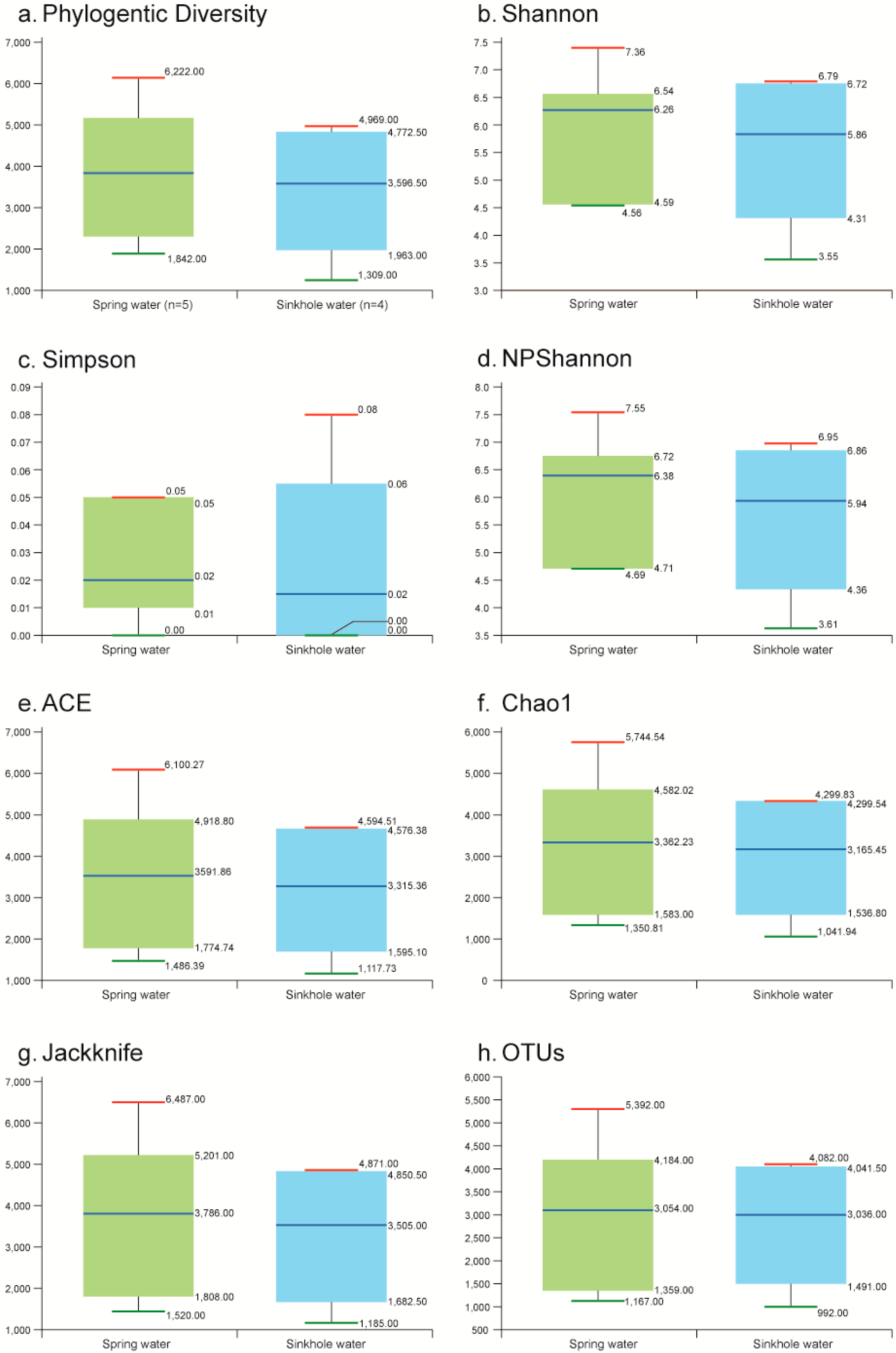
3.2. Microbial Composition

A total of 327,973 sequences and 26,221 OTUs were obtained from the tests conducted on the nine water samples in this study. Figure 8 shows that there are some variations in the compositions at the phylum level among the samples. A total of 14 phyla were identified in the nine samples. Figure 8 describes the distribution of the bacterial groups. The large bacterial proportions were identified as Proteobacteria, Bacteriodetes, Actinobacteria, Verrucomicrobia, Acidobacteria, Planctomycetes and Firmicutes. Smaller proportions of Parcubacteria, Peregrinibacteria, Saccharibacteria, Cyanobacteria, Nitrospirae, Gemmatimonadetes and Chloroflexi were also identified.
Proteobacteria was the most abundant phylum in all the samples, at 28.79–73.20%. Bacteriodetes were the second most abundant phylum at 7.95–30.40%. Actinobacteria was the other prevalent phylum in water samples HMS14 (47.31%), HMS11 (45.60%), HMS8 (6.05%), HMS2 (5.37%), SJS1 (3.79%), YSS3 (3.35%) and HMS1 (1.94%). The phylum compositions of HMS11 and HMS14 showed a similarity, with high proportions of Actinobacteria and the absence of Acidobacteria. Both of these sample points were located close to the East Sea. Furthermore, samples KSG1 and SJS4 also did not have Acidobacteria.
KGS1 had a monotonous taxonomy, comprised of Proteobacteria and Bacteriodetes. KGS1 is located in a limestone mining area where mining activity is causing rapid environmental changes. Extreme environmental changes, such as mining in the karst environment, could trigger the reduction of species or the abundance of special species, which can be more pronounced than the effect of sea water [40]. In HMS2, bacteria belonging to the phyla Gemmatimonadetes and Chloroflexi comprise 1.08% and 1.78% of all the bacterial communities, respectively. The presence of Gemmatimonadetes suggests an adaptation to low soil moisture in the environmental sample [53]. Among the Proteobacteria, β-Proteobacteria was the most commonly present class, with abundances of 62.5%, 34.2%, 25.2%, 24.4%, 19.3%, 17.3%, 17.2%, 16.7% and 9.9%, in the samples HMS1, HMS2, HMS8, HMS11, HMS14, KGS1, SJS1, SJS4 and YSS3, respectively.
UniFrac cluster analyses for each of the points showed that the bacterial communities in HMS11 and HMS14, though highly similar, were significantly different from those associated with KGS1. HMS11 and HMS14 are located adjacent to the East Sea. Actinobacteria are highly affected by the presence of sulfide and chloride [54]. The results suggest that the presence of specific bacteria, based on taxonomic classification at the sampling locations, may reflect the hydrological characteristics of the corresponding water samples, except for samples HMS11 and HMS14, in which 50% of the sequences were classified at the Actinobacteria phylum level.
Moreover, Figure 9 shows the phylum compositions of samples based on the hydrogeological types of the samples, that is, from sinkhole and spring points. A clear distinction was evident in the microbial community based on hydrogeological conditions. Proteobacteria, Bacteroidetes and Verrucomicrobia were the major phyla in both the spring and sinkhole point samples. However, the spring points were heavily loaded with Actinobacteria. In particular, Firmicutes were only present in the spring points at a level 4.3%. These microbial composition results are consistent with the hydrogeological composition results. Furthermore, variations in the ecological indices may indicate the substantial influence exerted by the surrounding environment on the spring and sinkhole waters during transport within the karst areas.
In order to analyze the bacterial alpha diversity in the nine stream water sampling sites, the samples were classified according to their stream water qualities, with respect to operational taxonomic units (OTUs), phylogenetic diversity and biotic diversity indices such as ACE, Chao1, jackknife, NPShannon and Shannon [41] (Figure 10). In the samples from the spring points, only the Simpson index was low, and the rest of the diversity indices were observed to be high. In the sinkhole waters, most of the indices, except for Simpson’s, were observed to be low. Therefore, the bacterial species’s richness and diversity were higher in the spring waters than in the sinkhole waters.

4. Conclusions

The heterogeneous nature of karst hydrology has made it difficult to attempt to define a flow system, to establish reliable biomarkers to estimate the environmental conditions, and to monitor the karst area water flow system. This was exacerbated by the lack of previous research and the limited adaptation of molecular biological methods, as well as the unpredictability of the flow system in the karst area. To date, molecular techniques for microbial community identification have been employed to establish the presence of a variety of bacteria in hydrogeological studies. However, no study has so far identified unique and consistent biomarkers for identification in karst sinkhole and spring waters, or established their hydrogeological variability. In the present study, we were able to document several aspects of the effects of hydrogeological flow conditions (i.e., sink and spring points) on the presence and distribution of microbial communities in karst waters. Our results provide valuable information for the evaluation and investigation of microbial compositions in the heterogeneous karst hydrology. The microbial species in karst areas are already exposed to changing hydrogeological conditions, and are likely to be confronted with future changes. Thus, their spatiotemporal variations are capable of reflecting the shifting baselines of physicochemical and ecosystem processes. Some species of bacteria may already be under evolutionary pressure caused by the unique hydrogeological stressors present in karst areas. Therefore, the evaluation of the hydrogeological characteristics of a karst area, along with their microbiological characterization, might have potentially important impacts on biodiversity, and this could have bearings on the compositions of the karst aquatic systems. There is an urgent need to prioritize such studies, and to obtain comprehensive information on the karst hydrogeological environment with data on bacterial compositions of the karst area environment, including their alpha and beta diversities. Such scientific knowledge regarding these microbial compositions and their effects on hydrogeological characteristics is essential for the development of karst hydrology.

Author Contributions

Conceptualization, H.K. and J.-Y.L.; methodology, H.K. and J.J.; software, J.J. and C.-S.K.; validation, J.-Y.L., H.K. and H.-S.R.; formal analysis, S.P.; investigation, C.-S.K. and S.P.; resources, H.K.; data curation, H.-S.R. and J.J.; writing—original draft preparation, H.K.; writing—review and editing, J.-Y.L.; visualization, J.J. and S.P.; supervision, H.K. and J.-Y.L.; project administration, H.K.; funding acquisition, H.K. and J.-Y.L. All authors have read and agreed to the published version of the manuscript.

Funding

This research was financially supported by the Basic Science Research Program through the National Research Foundation of Korea (NRF) funded by the Ministry of Education (No. 2019R1A6A1A03033167 and No. 2019R1I1A2A01057002) and Korea Environment Industry & Technology Institute(KEITI) through Measurement and Risk assessment Program for Management of Microplastics Program funded by Korea Ministry of Environment(MOE)(2020003110010).

Conflicts of Interest

The authors declare no conflict of interest.

References

  1. Giese, M.; Reimann, T.; Bailly-Comte, V.; Maréchal, J.-C.; Sauter, M.; Geyer, T. Turbulent and Laminar Flow in Karst Conduits Under Unsteady Flow Conditions: Interpretation of Pumping Tests by Discrete Conduit-Continuum Modeling. Water Resour. Res. 2018, 54, 1918–1933. [Google Scholar] [CrossRef]
  2. Ćuk, M.; Jemcov, I.; MladenoviĆ, A.; Ilić, M. Čokorilo Hydrochemical impact of the hydraulic tunnel on groundwater in the complex aquifer system in Pirot, Serbia. Carbonates Evaporites 2020, 35, 1–17. [Google Scholar] [CrossRef]
  3. White, W.B. Geomorphology and Hydrology of Karst Terrains; Oxford University Press: Oxford, UK; New York, NY, USA, 1988; pp. 406–445. [Google Scholar]
  4. Williams, P.N.; Islam, M.R.; Adomako, E.; Raab, A.; Hossain, S.A.; Zhu, Y.-G.; Feldmann, J.; Meharg, A.A. Increase in Rice Grain Arsenic for Regions of Bangladesh Irrigating Paddies with Elevated Arsenic in Groundwaters. Environ. Sci. Technol. 2006, 40, 4903–4908. [Google Scholar] [CrossRef] [PubMed]
  5. Cole, J.; Coniglio, M.; Gautrey, S. The roloe of buried bedrock valleys on the development of karstic aquifers in flat-lying carbonate bedrock: Insights from Guelph Ontario, Canada. Hydrogeol. J. 2009, 17, 1411–1425. [Google Scholar] [CrossRef]
  6. Ryu, H.-S.; Lee, J.-Y.; Lim, C.-W.; Kim, K. Hydrochemical characteristics of groundwater and stream water in a karst area of Samcheok, Korea. J. Geol. Soc. Korea 2019, 55, 117–129. [Google Scholar] [CrossRef]
  7. Korea Ministry of Environment. Water Resources Basic Investigation Report. Available online: https://www.kwater.or.kr/eng/main.do (accessed on 22 May 2020).
  8. Duran, L.; Massei, N.; Lecoq, N.; Fournier, M.; Labat, D. Analyzing multi-scale hydrodynamic processes in karst with a coupled conceptual modeling and signal decomposition approach. J. Hydrol. 2020, 583, 124625. [Google Scholar] [CrossRef]
  9. Jiang, G.; Guo, F.; Wei, M. Hydrogeological characteristics of foot caves in a karst peak-forest plain in South China. Hydrogeol. J. 2020, 28, 535–548. [Google Scholar] [CrossRef]
  10. Ollivier, C.; Mazzilli, N.; Olioso, A.; Chalikakis, K.; Carrière, S.D.; Danquigny, C.; Emblanch, C. Karst recharge-discharge semi distributed model to assess spatial variability of flows. Sci. Total. Environ. 2020, 703, 134368. [Google Scholar] [CrossRef] [PubMed] [Green Version]
  11. Banks, V.; Jones, P. Hydrogeological Significance of Secondary Terrestrial Carbonate Deposition in Karst Environments. In Hydrogeology—A Global Perspective; IntechOpen: Rijeka, Croatia, 2012; pp. 43–78. [Google Scholar]
  12. Eisenlohr, L.; Bouzelboudjen, M.; Király, L.; Rossier, Y. Numerical versus statistical modelling of natural response of a karst hydrogeological system. J. Hydrol. 1997, 202, 244–262. [Google Scholar] [CrossRef]
  13. Eisenlohr, L.; Király, L.; Bouzelboudjen, M.; Rossier, Y. Numerical simulation as a tool for checking the interpretation of karst spring hydrographs. J. Hydrol. 1997, 193, 306–315. [Google Scholar] [CrossRef] [Green Version]
  14. Peterson, E.; Wicks, C.M. Characterization of the physical and hydraulic properties of the sediment in karst aquifers of the Springfield Plateau, Central Missouri, USA. Hydrogeol. J. 2003, 11, 357–367. [Google Scholar] [CrossRef]
  15. Upchurch, S.; Scott, T.M.; Alfieri, M.C.; Fratesi, B.; Dobecki, T.L. Hydrogeochemistry of Florida Karst Waters. In The Karst Systems of Florida; Upchurch, S., Scott, T.M., Alfieri, M.C., Fratesi, B., Dobecki, T.L., Eds.; Springer: Cham, Switzerland, 2019; pp. 145–206. [Google Scholar]
  16. Wicks, C.M.; Engeln, J.F. Geochemical evolution of a karst stream in Devils Icebox Cave, Missouri, USA. J. Hydrol. 1997, 198, 30–41. [Google Scholar] [CrossRef]
  17. Cao, J.-H.; Wu, X.; Huang, F.; Hu, B.; Groves, C.; Yang, H.; Zhang, C.-L. Global significance of the carbon cycle in the karst dynamic system: Evidence from geological and ecological processes. China Geol. 2018, 1, 17–27. [Google Scholar] [CrossRef]
  18. Guo, Y.; Wen, Z.; Zhang, C.; Jakada, H. Contamination and natural attenuation characteristics of petroleum hydrocarbons in a fractured karst aquifer, North China. Environ. Sci. Pollut. Res. 2020, 27, 22780–22794. [Google Scholar] [CrossRef] [PubMed]
  19. Hou, Z.; Wu, Z.; Li, W.; Gu, Y.; Situ, Y.; Xu, Y.; Mu, L. 2018 Annual Report: China National Committee for IGCP. Acta Geol. Sin. 2019, 93, 86–89. [Google Scholar] [CrossRef] [Green Version]
  20. Jiang, Z.; Zhang, C.; Qin, X.; Pu, J.; Bai, B. Structural Features and Function of the Karst Critical Zone. Acta Geol. Sin. 2019, 93, 109–112. [Google Scholar] [CrossRef] [Green Version]
  21. Luo, Q.K.; Cao, J.H.; Hu, M.Y.; Bai, B.; Zhong, L. Introduction of International Research Center on Karst under the auspices of UNESCO. China Geol. 2018, 1, 574–576. [Google Scholar]
  22. Zeyan, W.; Cheng, Z.; Zhongcheng, J.; Weiqun, L.; Faming, Z. Advance of karst critical zone and its carbon cycle. Adv. Earth Sci. 2019, 34, 488–498. [Google Scholar]
  23. Andreo, B. Introductory editorial: Advances in karst hydrogeology. Environ. Earth Sci. 2012, 65, 2219–2220. [Google Scholar] [CrossRef] [Green Version]
  24. Chen, Z.; Auler, A.S.; Bakalowicz, M.; Drew, D.; Griger, F.; Hartmann, J.; Jiang, G.; Moosdorf, N.; Richts, A.; Stevanovic, Z.; et al. The World Karst Aquifer Mapping project: Concept, mapping procedure and map of Europe. Hydrogeol. J. 2017, 25, 771–785. [Google Scholar] [CrossRef] [Green Version]
  25. Daoxian, Y. On the karst environmental system. In Proceedings of the IAH 21st Congress, Guilin, China, 10–15 October 1988; Volume 21, pp. 30–46. [Google Scholar]
  26. Fiorillo, F.; Stevanovic, Z. Introductory editorial thematic issue: Mediterranean karst hydrogeology. Environ. Earth Sci. 2015, 74, 1–3. [Google Scholar] [CrossRef] [Green Version]
  27. Goldscheider, N. Methods in Karst Hydrogeology; CRC Press: London, UK, 2014. [Google Scholar]
  28. Guo, F.; Jiang, G.; Yuan, D.; Polk, J.S. Evolution of major environmental geological problems in karst areas of Southwestern China. Environ. Earth Sci. 2012, 69, 2427–2435. [Google Scholar] [CrossRef]
  29. Kim, H. Book Review: Life and Water on Karst: Monitoring of transboundary water resources of Northern Istria. Episodes 2020, 43, 845–846. [Google Scholar] [CrossRef]
  30. Woo, K.S.; Choi, D.W. Calcitization of aragonite speleothems in limestone caves in Korea: Diagenetic process in a semiclosed system. In Perspectives on Karst Geomorphology, Hydrology, and Geochemistry—A Tribute Volume to Derek C. Ford and William B. White; Geological Society of America: Boulder, CO, USA, 2006; Volume 404, pp. 297–306. [Google Scholar]
  31. Woo, K.S.; Won, J.K.; Lee, G.C.; Namkoong, C.; Choi, Y.K. Comprehensive Investigation Report of Chodang Cave; Samcheok City Hall: Samcheok, Korea, 2000; p. 202. [Google Scholar]
  32. Geyer, G. A comprehensive Cambrain correlation chart. Episodes 2019, 42, 321–332. [Google Scholar]
  33. Won, J.K.; Park, B.K.; Lee, S.H. Geological Report on Samcheock-Gosari Sheet; KIGAM: Daejeon, Korea, 1994. [Google Scholar]
  34. Lee, S.M.; Kim, H.S.; Oh, I.S. Metamorphic petrology of Precambrian gneisses in Samcheok-Jukbyeon area. J. Geol. Soc. Korea 1986, 22, 257–277. [Google Scholar]
  35. Kim, Y.H.; Kim, G.B.; Choi, S.G.; Kim, C.S. SWIR application for the identification of high-grade lime stones from the Upper Pungchon formation. Econ. Environ. Geol. 2016, 49, 335–347. [Google Scholar] [CrossRef] [Green Version]
  36. Noh, J.H.; Oh, S.J. Hydrothermal alteration of the Pungchon limestone and the formation of high-Ca limestone. J. Geol. Soc. Korea 2005, 41, 175–197. [Google Scholar]
  37. Ha, K.-J.; Park, S.-K.; Kim, K.-Y. On interannual characteristics of Climate Prediction Center merged analysis precipitation over the Korean peninsula during the summer monsoon season. Int. J. Clim. 2005, 25, 99–116. [Google Scholar] [CrossRef]
  38. Lee, H.; Song, H.-J.; Sohn, B.-J. Possible Mechanisms of Long-Term Trend of June Rainfall over the Korean Peninsula. Asia-Pac. J. Atmos. Sci. 2020, 1–12. [Google Scholar] [CrossRef] [Green Version]
  39. Kim, H.; Kaown, D.; Mayer, B.; Lee, J.-Y.; Hyun, Y.; Lee, K.-K. Identifying the sources of nitrate contamination of groundwater in an agricultural area (Haean basin, Korea) using isotope and microbial community analyses. Sci. Total. Environ. 2015, 533, 566–575. [Google Scholar] [CrossRef]
  40. Lee, K.S.; Lee, C.B. Oxygen and hydrogen isotope composition of precipitation and river waters in South Korea. J. Geol. Soc. Korea 1999, 35, 73–84. [Google Scholar]
  41. Kim, H.; Lee, K.-K.; Heejung, K.; Kang-Kun, L. Effect of vertical flow exchange on microbial community distributions in hyporheic zones. Episodes 2019, 42, 1–16. [Google Scholar] [CrossRef]
  42. Kim, H.; Kawon, D.; Kim, J.; Park, I.-W.; Joun, W.-T.; Lee, K.-K. Impact of earthquake on the communities of bacteria and archaea in groundwater ecosystems. J. Hydrol. 2020, 583, 124563. [Google Scholar] [CrossRef]
  43. Kim, H.; Kaown, D.; Mayer, B.; Lee, J.Y.; Lee, K.K. Combining pyrosequencing and isotope approaches to access denitrification in a hyporheic zone. Sci. Total Environ. 2018, 631–632, 755–764. [Google Scholar] [CrossRef] [PubMed]
  44. Edgar, R.C.; Haas, B.J.; Clemente, J.C.; Quince, C.; Knight, R. UCHIME improves sensitivity and speed of chimera detection. Bioinformatics 2011, 27, 2194–2200. [Google Scholar] [CrossRef] [PubMed] [Green Version]
  45. Rivera, S.F.; Vasselon, V.; Bouchez, A.; Rimet, F. Diatom metabarcoding applied to large scale monitoring networks: Optimization of bioinformatics strategies using Mothur software. Ecol. Indic. 2020, 109, 105775. [Google Scholar] [CrossRef]
  46. Schloss, P.D.; Westcott, S.L.; Ryabin, T.; Hall, J.R.; Hartmann, M.; Hollister, E.B.; Lesniewski, R.A.; Oakley, B.B.; Parks, D.H.; Robinson, C.J.; et al. Introducing mothur: Open-Source, Platform-Independent, Community-Supported Software for Describing and Comparing Microbial Communities. Appl. Environ. Microbiol. 2009, 75, 7537–7541. [Google Scholar] [CrossRef] [PubMed] [Green Version]
  47. Lozupone, C.; Knight, R. UniFrac: A New Phylogenetic Method for Comparing Microbial Communities. Appl. Environ. Microbiol. 2005, 71, 8228–8235. [Google Scholar] [CrossRef] [PubMed] [Green Version]
  48. Schloss, P.D. Evaluating different approaches that test whether microbial communities have the same structure. ISME J. 2008, 2, 265–275. [Google Scholar] [CrossRef] [PubMed] [Green Version]
  49. Pu, J.; Yuan, D.; Xiao, Q.; Zhao, H. Hydrogeochemical characteristics in karst subterranean streams: A case history from Chongqing, China. Carbonates Evaporites 2015, 30, 307–319. [Google Scholar] [CrossRef]
  50. Buczyński, S.; Rzonca, B. Influence of geologic structure on the presence, discharge and physical and chemical properties of springs in the Muszynka catchment (Carpathian flysch). Episodes 2018, 41, 89–96. [Google Scholar] [CrossRef]
  51. Canfield, D.E.; Berner, R.A. Dissolution and pyritization of magnetite in anoxie marine sediments. Geochim. Cosmochim. Acta 1987, 51, 645–659. [Google Scholar] [CrossRef]
  52. Gibbs, R.J. Mechanisms Controlling World Water Chemistry. Science 1970, 170, 1088–1090. [Google Scholar] [CrossRef] [PubMed]
  53. Debruyn, J.M.; Nixon, L.T.; Fawaz, M.N.; Johnson, A.M.; Radosevich, M. Global Biogeography and Quantitative Seasonal Dynamics of Gemmatimonadetes in Soil. Appl. Environ. Microbiol. 2011, 77, 6295–6300. [Google Scholar] [CrossRef] [PubMed] [Green Version]
  54. Wani, A.A.; Surakasi, V.P.; Siddharth, J.; Raghavan, R.G.; Patole, M.S.; Ranade, D.; Shouche, Y.S. Molecular analyses of microbial diversity associated with the Lonar soda lake in India: An impact crater in a basalt area. Res. Microbiol. 2006, 157, 928–937. [Google Scholar] [CrossRef] [PubMed]
Figure 1. Unique hydrogeological features of a karst area.
Applsci 10 04714 g001
Figure 2. Geology of the study area.
Applsci 10 04714 g002
Figure 3. Hydrogeological conditions of karst area (a) sinking points (b) spring points.
Applsci 10 04714 g003
Figure 4. Annual precipitation and average air temperature in the study area from 2000 to 2019.
Applsci 10 04714 g004
Figure 5. Sampling points in the study area.
Applsci 10 04714 g005
Figure 6. Piper diagram showing water types using major cations and anions in the sampled stream waters in the karst area (red circles indicate spring waters and blue marks indicate sinkhole waters).
Applsci 10 04714 g006
Figure 7. Gibbs plots of the karst stream water samples.
Applsci 10 04714 g007
Figure 8. Taxonomic classification of bacteria reads at phylum and class level, and UniFrac UPGMA clustering of the bacteria communities.
Applsci 10 04714 g008
Figure 9. Taxonomic classification of bacteria reads at phylum and class level retrieved from different water conditions (sink and spring points).
Applsci 10 04714 g009
Figure 10. Microbial diversity estimators obtained from the water samples. Alpha and Beta diversity of bacteria.
Applsci 10 04714 g010
Table 1. Hydrogeochemical data of the water samples collected in the study area.
ParameterHamaengbang AreaKyogok AreaYeosam AreaSajik Area
nMax.Min.MeanSD *CV **nMax.Min.MeanSD *CV **nMax.Min.MeanSD *CV **nMax.Min.MeanSD *CV **
Temp. (°C)1729.85.017.56.637.81729.85.017.56.637.8517.57.713.14.231.9612.38.910.51.413.5
pH178.76.18.10.67.6178.76.18.10.67.658.78.18.40.22.868.57.78.00.34.3
EC (μS/cm)17504.0170.2309.678.125.217504.0170.2309.678.125.25305.081.7244.392.838.0614,850.0464.05,513.76,244.8113.3
DO (mg/L)179.25.16.81.318.6179.25.16.81.318.658.15.46.71.319.467.65.96.80.811.3
ORP (mV)17261.083.0192.746.424.117261.083.0192.746.424.15241.0176.0200.824.512.26197.095.0142.737.926.5
Turbidity (NTU)17892.01.0123.8242.1195.617892.01.0123.8242.1195.6537.60.516.415.091.86217.00.641.586.2207.9
Ca2+ (mg/L)1576.626.057.814.825.51576.626.057.814.825.5462.349.955.86.010.8375.166.470.24.56.4
Mg2+ (mg/L)156.43.85.00.815.7156.43.85.00.815.749.74.96.42.235.1399.67.338.752.8136.5
Na+ (mg/L)159.54.86.11.322.0159.54.86.11.322.045.44.75.10.36.33837.09.5287.6475.8165.4
K+ (mg/L)153.00.81.70.636.0153.00.81.70.636.041.00.70.80.113.1337.33.014.919.5131.0
HCO3 (mg/L)15155.938.479.928.035.115155.938.479.928.035.14135.370.5103.836.234.9372.237.659.318.931.8
SO42 (mg/L)1512.56.28.61.821.21512.56.28.61.821.247.05.46.50.711.23257.037.9122.0118.196.8
Cl (mg/L)1570.24.935.221.059.71570.24.935.221.059.748.36.37.60.912.1318.18.915.05.335.5
NO3 (mg/L)1541.25.513.611.886.91541.25.513.611.886.9412.97.710.52.422.731,652.120.9566.8939.9165.8
δ13C (‰)15−9.4−14.3−11.51.3−11.115−9.4−14.3−11.51.3−11.14−10.5−13.8−12.11.8−14.83−8.8−11.2−9.71.3−13.6
δ18O (‰)15−7.2−8.5−8.00.3−3.915−7.2−8.5−8.00.3−3.94−8.2−8.7−8.50.2−2.53−8.1−8.5−8.30.2−2.2
δ2D (‰)15−45.1−54.1−49.82.4−4.815−45.1−54.1−49.82.4−4.84−52.2−55.0−53.41.2−2.23−51.5−55.5−52.92.2−4.1
EC: Electrical Conductivity, DO: Dissolved Oxygen, ORP: Oxidation-Reduction Potential, Max.: Maximum, Min.: Minimum, SD *: standard deviation, CV **: coefficient of variation.

