1. Introduction
According to the Emergency Events Database (https://public.emdat.be/), in 2019 at least 51 geohazards in the form of earthquakes, landslides, and volcanoes were reported globally, claiming the lives of 1010 people, affecting ~1.7 million others, and costing 2.6 billion US$. There is therefore an urgent demand to better understand the risk and mitigate the human and socio-economic impact of geohazards, which is currently being supported through use of a wealth of earth observation (EO) data and products that are either freely available or more readily accessible [1,2,3]. Better disaster management strategies in which new EO technologies and data have been incorporated have likely contributed to the decreasing trend between 1900–2008 and 2009–2019 in the average number of deaths (~1100 vs. ~500) and people affected (~89,000 vs. ~79,000) per geological disaster event.
With this in mind, this Special Issue was introduced to showcase some of the latest EO-based research on the ‘Mapping and Monitoring of Geohazards’. A set of diverse state-of-the-art methodologies are presented, which can be applied to the mapping and monitoring of geohazards to ultimately help build more resilient societies. A total of 12 papers were accepted for publication in the Special Issue, addressing a variety of issues associated with earthquakes, landslides, and volcanoes.
2. Mapping and Monitoring of Geohazards
The published papers cover three types of geohazards across eight different countries: earthquake [4,5,6], landslide [7,8,9,10,11,12,13,14], and volcanic hazards [15]. As of 21st May 2020, almost 6 months after the deadline for submissions, the 12 papers have been viewed 6096 times, downloaded 4868 times, and cited 16 times overall.
2.1. Earthquake Hazard
Three papers are dedicated to earthquake hazards, the first of which is authored by Issaadi et al. [4]. This paper presents an improved subsurface characterization of soil characteristics through a horizontal-to-vertical spectral ratio method, with a view to mitigating future seismic damage in the city of Oued-Fodda (Algeria).
The second paper by Lee et al. [5] establishes constraints on the acoustic sound level of the 2017 Pohang Earthquake (South Korea) using an underwater glider. This analysis can be critical for a comprehensive analysis of seismic sources offshore to be used in the earthquake disaster risk assessment of coastal zones.
The third paper on the seismic hazard theme is authored by Aguirre-Salado et al. [6], and it proposes a novel spatial model-based approach for estimating the maximum intensity levels of earthquakes for cases where there is an incomplete database of historic earthquakes. Their findings indicate areas with the highest seismic risk, which can aid administrative authorities in southern Mexico in improving prevention policies.
2.2. Landslide Hazard
Landslide hazards received the most attention, with eight papers focussing on this topic. The first paper by Hölbling et al. [7] aims to semi-automatically map the evolution of the Butangbunasi landslide (Taiwan) using satellite EO data and investigate the potential correlation between changes in the landslide area and heavy rainfall.
The second paper, by Liu et al. [8], provides a landslide hazard assessment along the Yarlung Tsangpo River basin (Tibet Autonomous Region, China) using unmanned aerial vehicle (UAV) imagery. This allowed for the identification of rockfall source areas threatening the local highway, which were lacking in detailed historical data. The hazard assessment results will provide detailed information for any geohazards prevention work.
Thirdly, the paper authored by Infante et al. [9] proposes a semiautomatic Geographic Information System (GIS) approach, within which satellite radar interferometry (InSAR) data and geomorphological field surveys are integrated in a qualitative vulnerability matrix in order to identify different levels of damage susceptibility along a provincial road located in the Campania region (Italy).
The fourth paper, by Gudiyangada Nachappa et al. [10], uses an object-based geons aggregation model for landslide susceptibility mapping (LSM) for the whole of Austria, which is a key step in the risk assessment of landslides. This study also demonstrates that geons allow for meaningful units to be obtained that are more beneficial than pixels for planning purposes.
In similarity to [10], the paper by Yu et al. [11] also focusses on LSM, but in the Three Gorges Reservoir area (Chongqing municipality, China). It employs an information gain ratio (IGR) model to select landslide causal factors, before subsequently exploring the performance of machine learning models, including support vector machines (SVM), for LSM.
The sixth paper on landslides, authored by Guo et al. [12], uses an association rule mining algorithm, Apriori, to uncover the cause–effect relationships in landslides hazard prediction. An optimised algorithm, known as IAprioriMR, is proposed and applied for the early warning study of landslide events in the Three Parallel Rivers area (Yunnan province, China).
The seventh paper, authored by Li et al. [13], is concerned with LSM for the Shicheng County (China) based on the particle-swarm-optimized multilayer perceptron (PSO-MLP) model. The authors acknowledge that LSM is necessary for the local government to carry out landslide hazard prevention and land use planning, and further suggest that the PSO-MLP is capable of outperforming other LSM approaches.
Lastly, the paper by Xing et al. [14] focusses on landslide displacement forecasting in order to reduce the hazard associated with the Dashuitian landslide (Chongqing municipality, China). The authors present a new dynamic forecasting model based on variational mode decomposition (VMD) and a stack long short-term memory (SLSTM) network, which achieves a higher forecast accuracy than two other advanced forecast models (long short-term memory (LSTM) network and empirical mode decomposition (EMD)-LSTM network).
2.3. Volcanic Hazard
Volcanic hazards are addressed in the paper by Novellino et al. [15]. This study characterises the shoreline changes associated with the volcanic activity in 2018–2019 at Anak Krakatau (Indonesia), spanning a major lateral collapse (that occurred on 22nd December 2018 [16]) and a period of regrowth through explosive activity. The study highlights the potential for satellite-based automated shoreline mapping to provide databases for monitoring the hazard associated with remote island volcanoes.
3. Future Developments for the Mapping and Monitoring of Geohazards
The papers published in the MDPI Special Issue on “Mapping and Monitoring of Geohazards” reveal the latest trends in characterising and enhancing our understanding of the risks posed by geohazards and landslides in particular. With a wide array of spaceborne, airborne, and ground-based sensors available, encompassing different spatial, temporal and radiometric resolutions, and characteristics of the phenomena, we are in the ‘Golden Age’ of EO. As a consequence, EO is now, more than ever, routinely playing a crucial role in the mapping and monitoring of natural hazards.
With regards to the spaceborne domain, two programmes in particular have been largely responsible for driving the uptake of EO data for mapping and monitoring geohazards. These are the Landsat constellation from the United States Geological Survey and the Sentinel missions from the European Space Agency. In large part, this is due to the increased data accessibility, with the provision of free satellite imagery since 2008 [17] and 2014 [18], respectively.
Along with new and more readily accessible EO data, the papers published in the Special Issue clearly demonstrate that computer science techniques, such as artificial intelligence and cloud computing platforms, are being progressively developed or adapted in geohazards research. Such techniques are being employed in order to tackle the issues related to downloading, managing, analysing, and interpreting big volumes of data [19].
The increased provision of data and associated processing techniques has clearly had a significant impact within the scientific community, which is reflected by the rapid growth of the number of papers in journals, books, and series on the use of EO for geohazards studies (Figure 1). Out of the 7196 publications between 1976 and 2019, around half of them were produced during the ‘Sentinel Era’, namely during or after 2014.
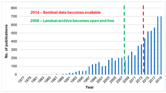
Figure 1.
Number of earth observation (EO)-related geohazards publications per year for papers in journals, books, and series. The search was performed through the Web of Science portal based on the following keywords (in quotes) and Boolean Operators (in uppercase): “Earth Observation” OR “Remote Sensing” AND “Geohazards”.
The next challenge we face is translating what are largely scientific outputs into products and information that the civil society can more routinely use in the disaster management cycle and in policy formation. It is then when the direct impact of the innovative and ground-breaking work of our scientific community in helping to mitigate the human and socio-economic impact of geohazards will be fully realised.
Acknowledgments
We are greatly indebted to all authors, reviewers and the editorial team of Applied Sciences, without whose support, time and expertise this Special Issue would not have been possible. We extend our thanks to all who have been involved in the compilation of this Special Issue at any stage.
Conflicts of Interest
The authors declare no conflict of interest.
References
- Toth, C.; Jóźków, G. Remote sensing platforms and sensors: A survey. ISPRS J. Photogramm. Remote Sens. 2020, 115, 22–36. [Google Scholar] [CrossRef]
- Novellino, A.; Jordan, C.; Ager, G.; Bateson, L.; Fleming, C.; Confuorto, P. Remote sensing for natural or man-made disasters and environmental changes. In Geological Disaster Monitoring Based on Sensor Networks; Springer: Singapore, 2019; pp. 23–31. [Google Scholar]
- Hunter, J.A.; Burns, R.A.; Good, R.L.; Pullan, S.E.; Pugin, A.; Crow, H. Near-surface geophysical techniques for geohazards investigations: Some Canadian examples. Lead. Edge 2010, 29, 964–977. [Google Scholar] [CrossRef]
- Issaadi, A.; Semmane, F.; Yelles-Chaouche, A.; Galiana-Merino, J.J.; Layadi, K. A Shear-Wave Velocity Model in the City of Oued-Fodda (Northern Algeria) from Rayleigh Wave Ellipticity Inversion. Appl. Sci. 2020, 10, 1717. [Google Scholar] [CrossRef]
- Lee, J.H.; Ko, S.H.; Jung, S.K.; Hyeon, J.W. Tertiary Waves Measured during 2017 Pohang Earthquake Using an Underwater Glider. Appl. Sci. 2019, 9, 3860. [Google Scholar] [CrossRef]
- Aguirre-Salado, A.I.; Vaquera-Huerta, H.; Aguirre-Salado, C.A.; Jiménez-Hernández, J.D.C.; Barragán, F.; Guzmán-Martínez, M. Facing Missing Observations in Data—A New Approach for Estimating Strength of Earthquakes on the Pacific Coast of Southern Mexico Using Random Censoring. Appl. Sci. 2019, 9, 2863. [Google Scholar] [CrossRef]
- Hölbling, D.; Abad, L.; Dabiri, Z.; Prasicek, G.; Tsai, T.T.; Argentin, A.L. Mapping and Analyzing the Evolution of the Butangbunasi Landslide using Landsat Time Series with Respect to Heavy Rainfall Events during Typhoons. Appl. Sci. 2020, 10, 630. [Google Scholar] [CrossRef]
- Liu, H.; Wang, X.; Liao, X.; Sun, J.; Zhang, S. Rockfall investigation and hazard assessment from Nang County to Jiacha County in Tibet. Appl. Sci. 2020, 10, 247. [Google Scholar] [CrossRef]
- Infante, D.; Di Martire, D.; Calcaterra, D.; Miele, P.; Scotto di Santolo, A.; Ramondini, M. Integrated Procedure for Monitoring and Assessment of Linear Infrastructures Safety (I-Pro MONALISA) Affected by Slope Instability. Appl. Sci. 2019, 9, 5535. [Google Scholar] [CrossRef]
- Gudiyangada Nachappa, T.; Tavakkoli Piralilou, S.; Ghorbanzadeh, O.; Shahabi, H.; Blaschke, T. Landslide Susceptibility Mapping for Austria Using Geons and Optimization with the Dempster-Shafer Theory. Appl. Sci. 2019, 9, 5393. [Google Scholar] [CrossRef]
- Yu, L.; Cao, Y.; Zhou, C.; Wang, Y.; Huo, Z. Landslide Susceptibility Mapping Combining Information Gain Ratio and Support Vector Machines: A Case Study from Wushan Segment in the Three Gorges Reservoir Area, China. Appl. Sci. 2019, 9, 4756. [Google Scholar] [CrossRef]
- Guo, W.; Zuo, X.; Yu, J.; Zhou, B. Method for Mid-Long-Term Prediction of Landslides Movements Based on Optimized Apriori Algorithm. Appl. Sci. 2019, 9, 3819. [Google Scholar] [CrossRef]
- Li, D.; Huang, F.; Yan, L.; Cao, Z.; Chen, J.; Ye, Z. Landslide Susceptibility Prediction Using Particle-Swarm-Optimized Multilayer Perceptron: Comparisons with Multilayer-Perceptron-Only, BP Neural Network, and Information Value Models. Appl. Sci. 2019, 9, 3664. [Google Scholar] [CrossRef]
- Xing, Y.; Yue, J.; Chen, C.; Cong, K.; Zhu, S.; Bian, Y. Dynamic Displacement Forecasting of Dashuitian Landslide in China Using Variational Mode Decomposition and Stack Long Short-Term Memory Network. Appl. Sci. 2019, 9, 2951. [Google Scholar] [CrossRef]
- Novellino, A.; Engwell, S.L.; Grebby, S.; Day, S.; Cassidy, M.; Madden-Nadeau, A.; Watt, S.; Pyle, D.; Abdurrachman, M.; Edo Marshal Nurshal, M.; et al. Mapping recent shoreline changes spanning the lateral collapse of Anak Krakatau Volcano, Indonesia. Appl. Sci. 2020, 10, 536. [Google Scholar] [CrossRef]
- Grilli, S.T.; Tappin, D.R.; Carey, S.; Watt, S.F.; Ward, S.N.; Grilli, A.R.; Engwell, S.L.; Zhang, C.; Kirby, J.T.; Schambach, L.; et al. Modelling of the tsunami from the December 22, 2018 lateral collapse of Anak Krakatau volcano in the Sunda Straits, Indonesia. Sci. Rep. 2019, 9, 1–13. [Google Scholar] [CrossRef] [PubMed]
- Zhu, Z.; Wulder, M.A.; Roy, D.P.; Woodcock, C.E.; Hansen, M.C.; Radeloff, V.C.; Healey, S.P.; Schaaf, C.; Hostert, P.; Strobl, P.; et al. Benefits of the free and open Landsat data policy. Remote Sens. Environ. 2019, 224, 382–385. [Google Scholar] [CrossRef]
- Berger, M.; Moreno, J.; Johannessen, J.A.; Levelt, P.F. and Hanssen, R.F. ESA’s sentinel missions in support of Earth system science. Remote Sens. Environ. 2012, 120, 84–90. [Google Scholar] [CrossRef]
- Sudmanns, M.; Tiede, D.; Lang, S.; Bergstedt, H.; Trost, G.; Augustin, H.; Baraldi, A.; Blaschke, T. Big Earth data: Disruptive changes in Earth observation data management and analysis? Int. J. Digit. Earth 2019, 1–19. [Google Scholar] [CrossRef]

© 2020 by the authors. Licensee MDPI, Basel, Switzerland. This article is an open access article distributed under the terms and conditions of the Creative Commons Attribution (CC BY) license (http://creativecommons.org/licenses/by/4.0/).