


Abstract
Cities are artificial ecosystems that suffer most from environmental issues and climate change. Urban Heat Island (UHI) effects represent an increasing challenge, especially for compact Mediterranean cities characterized by high population density and extensive impervious surfaces. This study assessed localized microclimatic conditions within the small Maltese coastal town of Isla through a 15-day summer field monitoring campaign. Air temperature, relative humidity, and wind speed were measured across urban locations characterized by different levels of vegetation coverage and thermal vulnerability. The analysis combined descriptive statistics, Mann–Whitney U testing, and Multiple Linear Regression (MLR) models. In addition, site-specific Nature-based Solutions (NbS) scenarios were proposed as context-sensitive strategies to support urban heat mitigation and climate resilience. The results highlighted distinct microclimatic responses between the sites investigated. In particular, the MLR analysis suggested that non-vegetated areas were more sensitive to short-term atmospheric variability associated with wind speed and relative humidity fluctuations. These findings suggest that urban vegetation may contribute not only to localized cooling, but also to increased microclimatic stability within compact Mediterranean urban environments.
1. Introduction
The world’s population growth mirrors how humans over the years have increasingly succeeded in exploiting Earth’s resources to survive and evolve, often without caring about the consequences. During the past 15 years, urbanization has experienced a fast growth rate, estimated to reach 83.7% by 2050 in Europe [1]. Cities are artificial ecosystems in which the consumption and degradation of natural capital is incomparably high. The gradual escalation of phenomena such as pollution, biodiversity loss, depletion of natural resources and soil sealing, especially in urban areas, testifies to a substantial human-induced disruption of ecological balances. This growing anthropic influence, especially through urbanization, increasingly alters local microclimates, intensifying phenomena such as Urban Heat Islands (UHIs).
Climatic conditions are significantly different from adjacent rural areas, in which green cover and vegetation reduce the occurrence of overheating phenomena [2]. Paved ground, buildings and narrow streets trap solar radiation, and are then released together with artificial heat from human activities fostering the microclimatic phenomenon of UHI [3]. The Intergovernmental Panel on Climate Change’s (IPCC) Sixth Assessment Report [4] affirms that our planet, in the last 50 years, saw an increase in the frequency of heat waves, which adversely affected the health, lifestyles and productivity of people. Specifically, they resulted in the mortality of people and agricultural and economic losses. Future projections present an increase in the mean temperature in all European regions [5]. Climate change, especially in urban environments, is causing significant social and economic damage, affecting people’s quality of life. Elevated temperatures can plague communities’ health, as well as greatly increase the energy consumption of household appliances and cooling systems [6]. Furthermore, rising temperatures lead to increased production of greenhouse gases and tropospheric ozone, as strong solar radiation incentivizes the production of NOx and VOCs, the main ingredients for ozone formation [7]. Water quality is also reduced. When warm water from overheated urban settlements ends up flowing into local streams, it stresses the native species that are used to live in cooler aquatic environments [8]. Such urban microclimatic alterations not only affect ecological balances but also have direct consequences on human health, energy consumption, and ecosystems’ quality.
In the Mediterranean basin, climate change strongly interacts with other environmental problems, resulting from urbanization, pollution, and degradation of land and marine habitats. Due to its vulnerability, the Mediterranean region is a target for combined climate risks, which do not only threaten the environment, but also influence human livelihood and affect the economic sector [9]. Mediterranean weather is known to be mainly affected by the Azores anticyclone and by the subtropical African anticyclone [10]. Different studies associate the anticyclonic pattern with the increase in UHI intensity [11,12,13]. In the Mediterranean region, the thermal difference between land and sea which creates sea breezes is more pronounced from spring to fall [14]. As a consequence of such air circulation, moisture transportation occurs. Studies have been conducted to understand the interaction between humidity and UHIs [15,16]. The latter are negatively correlated to the relative humidity; however, high levels of atmospheric moisture exacerbate the heat stress [17]. The presence of vegetation and the local wind field largely depend on urban structure but are essential in UHI mitigation [18]. Especially in coastal cities, sea breezes may also lower such an effect [19]. In the Mediterranean, where urbanization coincides with high summer temperatures, these effects are particularly critical, emphasizing the need for site-specific investigations on urban heat stress and mitigation strategies.
The island of Malta is among the smallest and most densely populated countries in the world. In 2022, the resident population on the island reached 542,051 [20], and despite the small size of the territory, the population density is around 1717 inhabitants per km2. Considering the influx of tourists, these numbers double throughout the year. The Maltese climate is the typical Mediterranean climate, characterized by mild winters and very hot summers [21]. The State of Climate 2022 declares that since 1952, Malta’s annual mean ambient temperature has increased by 1.5 °C, equivalent to a warming of 0.2 °C per decade [22]. In 2022, the Meteorological Office records based on the data from the nine weather stations installed across the archipelago [23] registered the lowest temperature of 4.2 °C in January and the highest peak of 39.2 °C in August [24]. Weather conditions in coastal cities are strongly influenced by the presence of the sea [25] and the contribution of anticyclonic patterns to the UHI effect is more pronounced between June and September [26]. Given its dense urban fabric, high summer temperatures, and population variability, Malta constitutes a highly suitable setting for the assessment of urban heat and the evaluation of possible Nature-based Solutions (NbS) implementation.
1.1. Nature-Based Solutions for Urban Heat Island Effect Mitigation
The Mediterranean region’s population has exceeded 500 million [27], 70% of which live in cities [28]. As people will continue to move to built-up areas, maintaining a high quality of life in urban areas is a priority. Contact with nature and biodiversity preserve human well-being [29]. Urbanization threatens the connectedness between people and nature, prioritizing gray infrastructures with lower biodiversity and ecosystem services, and therefore impacts human well-being [30,31,32].
Promoting sustainable urban planning is the key starting point for the transition toward more resilient cities. The renaturing of cities is the expression of biological sustainability in exploiting natural processes of ecosystems to support local biodiversity and restore the people–nature connection [33]. The integration of NbS into such a transformative pathway for urban sustainability reflects a holistic approach to reverse long trends of ecosystem degradation [34] and to provide ecological, economic, and social benefits in response to people’s needs [35]. NbS is considered an ‘umbrella’ term that encompasses a wide range of approaches and actions to adapt to climate change and disaster risk reduction [36]. The concept is clearly grounded in the ecosystem-based approach, for which a healthy natural and effectively managed ecosystem produces a large variety of services upon which human well-being depends [37]. In this way, the multifunctionality of NbS can play a key role in addressing both the climate and the biodiversity crises while accelerating transformative societal changes [38]. Most of the research performed on UHI effect mitigation strategies mentions the important role of NbS [39]. The Nature-Based Solutions—Technical Handbook [40] produced by Urban Nature Labs for practitioners provides detailed information on potentially applicable NbS to support cities’ and resources’ resilience. The main NbS associated with an indicator of performance for climate resilience and cooling services are summarized in Table 1.
Table 1.
Nature-based Solutions (NbS) for Urban Heat Island (UHI) effect mitigation [40].
Trees reduce the surrounding air temperature through a natural transpiration and shading effect [41]. At building level, green roofs and vertical greenery mitigate the UHI phenomenon through the evapotranspiration effect of plants and thus release less heat flux compared to traditional materials [42]. In general, urban greenery improves the air and water quality, enhances urban biodiversity, and increases the esthetic value of residential areas [43]. In line with the need to reach a resilient urban environment, it is crucial to understand and evaluate the suitability of green intervention within specific territorial contexts. Their sustainability heavily relies on how they are implemented and to what extent they can deliver multiple benefits. Inadequate maintenance practices or adaptation methods can result in financial inefficiencies [44].
1.2. Aim
The main objective of this study is to assess the influence of urban vegetation on localized microclimatic conditions in a small coastal town in Malta under summer UHI conditions. Specific objectives include: (i) collecting and analyzing in situ meteorological data (air temperature, relative humidity, wind speed) across multiple urban locations with different levels of vegetation coverage; (ii) identifying urban areas that are potentially vulnerable to overheating and short-term atmospheric variability; and (iii) proposing context-sensitive NbS to enhance local thermal comfort, biodiversity, and urban sustainability.
While previous studies have investigated UHI mitigation strategies in Mediterranean cities, there is a lack of empirical evidence from small, densely built towns like Isla, where unique urban morphology and limited green space present particular challenges [45,46,47,48,49,50,51]. This study fills this gap by providing site-specific microclimatic observations integrated with statistical analysis and by translating these findings into context-sensitive NbS design proposals for climate-resilient Mediterranean urban settlements.
2. Materials and Methods
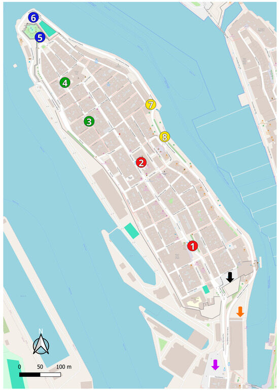
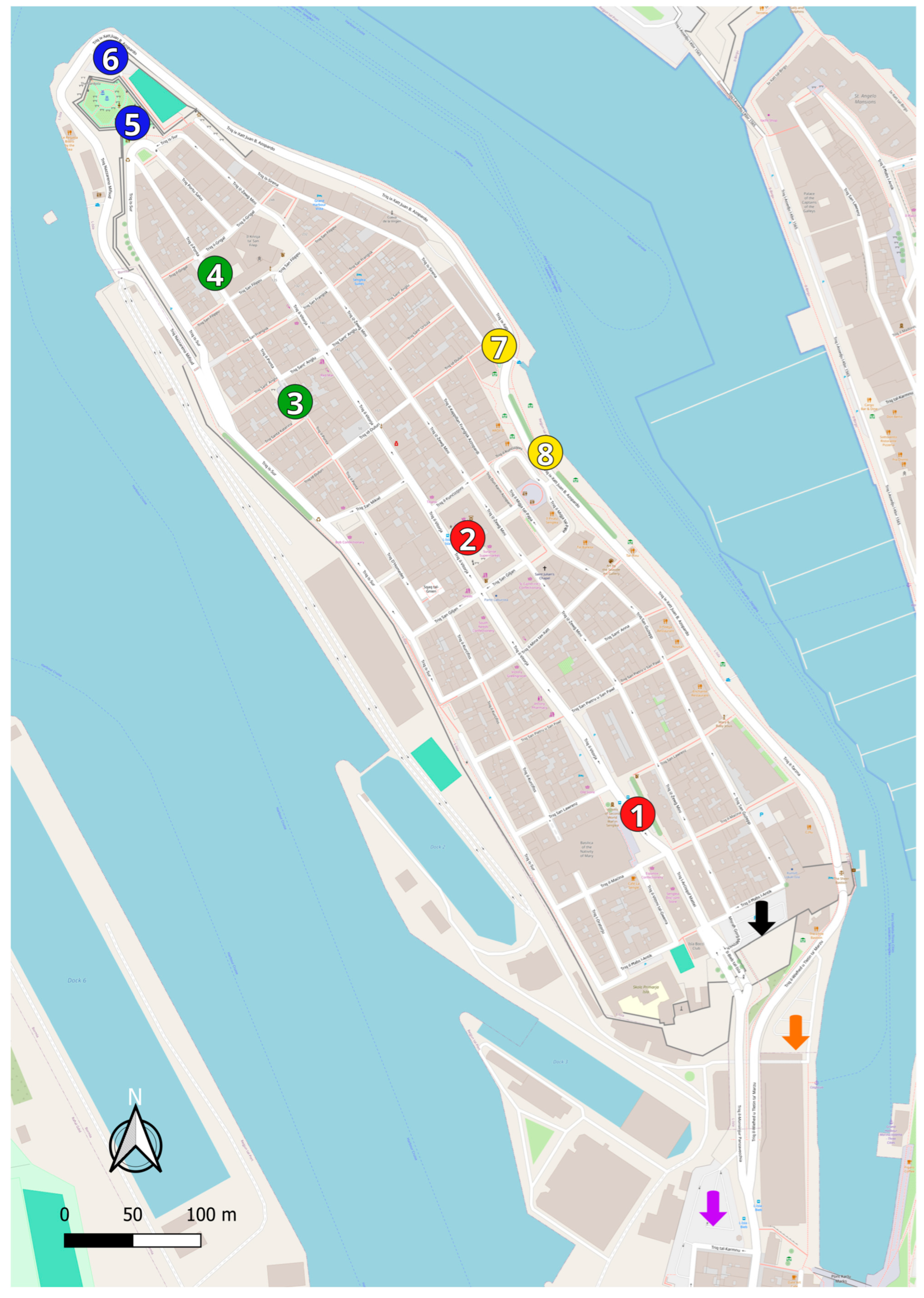
The conducted study investigated eleven areas (Figure 1) within the Maltese town of Isla (also known as Senglea). The air temperature, relative humidity, and wind speed were measured daily at each site over a 15-day monitoring period in late summer, a season characterized by peak temperatures in the Mediterranean climate. The parameters were collected at approximately the same time each day to minimize the diurnal variability; however, data acquisition across sites was performed sequentially rather than simultaneously, due to logistical constraints that were inherent to mobile field surveys. Consequently, short time lags between measurements at different locations may have occurred. For instance, minor deviations in sampling time occurred on 3 September and on 20 August due to an adjusted measurement route. Meteorological parameters such as wind speed and relative humidity naturally fluctuated during the monitoring period. These variations reflect typical late summer conditions in Malta and are considered when interpreting the observed microclimatic differences.
Figure 1.
Map of Isla with markers highlighting measurement locations [52]. The numbered circles identify the eight sites grouped into four comparative pairs according to vegetation presence and thermal characteristics, with each pair distinguished by a specific color code (red: location 1-location 2; green: location 3-location 4; blue: location 5-location 6; yellow: location 7-location 8). Colored arrows indicate the three additional locations analyzed individually for their potential urban regeneration. Base map from © OpenStreetMap contributors, then elaborated by the authors using QGIS 3.40.8.
For eight of the eleven areas, a comparative analysis was conducted to assess temperature variations in relation to the presence of vegetation. First, an initial analysis was performed using descriptive statistics, including the mean, standard deviation, range, and skewness, to characterize the distribution of each variable across the monitored areas. Data normality was subsequently assessed using the Shapiro–Wilk test. Based on these results, non-parametric statistical methods were adopted where variables did not meet the normal distribution (e.g., wind speed), using the Mann–Whitney U test (implemented in JASP software version 0.96.0.0, University of Amsterdam, Amsterdam, The Netherlands). In addition, a Multiple Linear Regression (MLR) analysis was performed to evaluate the relationship between the air temperature (dependent variable) and the other recorded environmental parameters, namely wind speed and relative humidity (independent variable).
These eight sites were grouped into four pairs, with each pair distinguished by a specific color code in Figure 1. The remaining three areas (indicated by colored arrows in Figure 1) were analyzed individually, with particular attention to their potential for urban regeneration and spatial reconfiguration.
Finally, the existing scientific studies and design experiences related to NbS were consulted to support the development of the different design scenarios, proposed both for the three areas analyzed in detail and for other locations where urban renaturing was considered necessary. These sources were used qualitatively to guide the design process and to ensure coherence with established approaches.
The present study reports results and discussion for only two insightful cases, due to length constraints.
2.1. Case Study
Isla is a small peninsula located in the Southeastern region of Malta at approximately 35° N and 14° E. Isla is built on a grid plan (Figure 1) inside an ancient fort placed on a promontory of just 0.16 km2. The latest census of 2021 shows a population of 2304 individuals, emphasizing an extremely high population density [53]. Historical prominence and proximity to the capital have made Isla a major tourist hub. Given the small size of the island, the climatic conditions described in Section 1 for the State of Malta also apply to the small town. Besides its location in the Mediterranean basin, classified as a climate change hot spot [54], Isla was selected as a case study because its distinctive land configuration and its high population density (14,418 individuals/km2 in 2021) limit its green areas to a communal vegetable garden and a small garden at the cape of the peninsula, challenging the implementation of new installation.
2.2. Equipment
The instrument used to collect meteorological parameters was the Skywatch Atmos, a portable anemometer (JDC Electronic SA, Yverdon-les-Bains, Switzerland) that was capable of recording the wind speed and relative humidity with a precision of ±3% and air temperature with a precision of ±0.4 °C [55]. Measurements could be obtained instantaneously, over fixed time intervals ranging from 3 s to 24 h, or by manually operating the chronometer using the control buttons on the device, as performed in the present study.
As the Skywatch Atmos is not equipped with a standardized radiation shield, particular care was taken to minimize the influence of direct solar radiation on the temperature and relative humidity values. Measurements were performed at approximately 2 m above ground under shaded or naturally ventilated conditions whenever possible. Each acquisition lasted 60 s to allow for partial sensor equilibration. Despite these precautions, some residual radiation-induced bias cannot be excluded, especially under low wind or high solar irradiance conditions.
At the end of each measurement period, the following parameters were recorded:
- Wind speed (km/h).
- Relative humidity (%rH).
- Air temperature (°C).
2.3. Location Descriptions
The selected locations are described by providing their spatial characterization, their functional role, and a representative image. This structured approach ensures consistency and clarity across all cases examined.
2.3.1. Misraħ il-Papa Benedettu XV, Triq il-Vitorja (35°53′09.0″ N 14°31′06.3″ E)
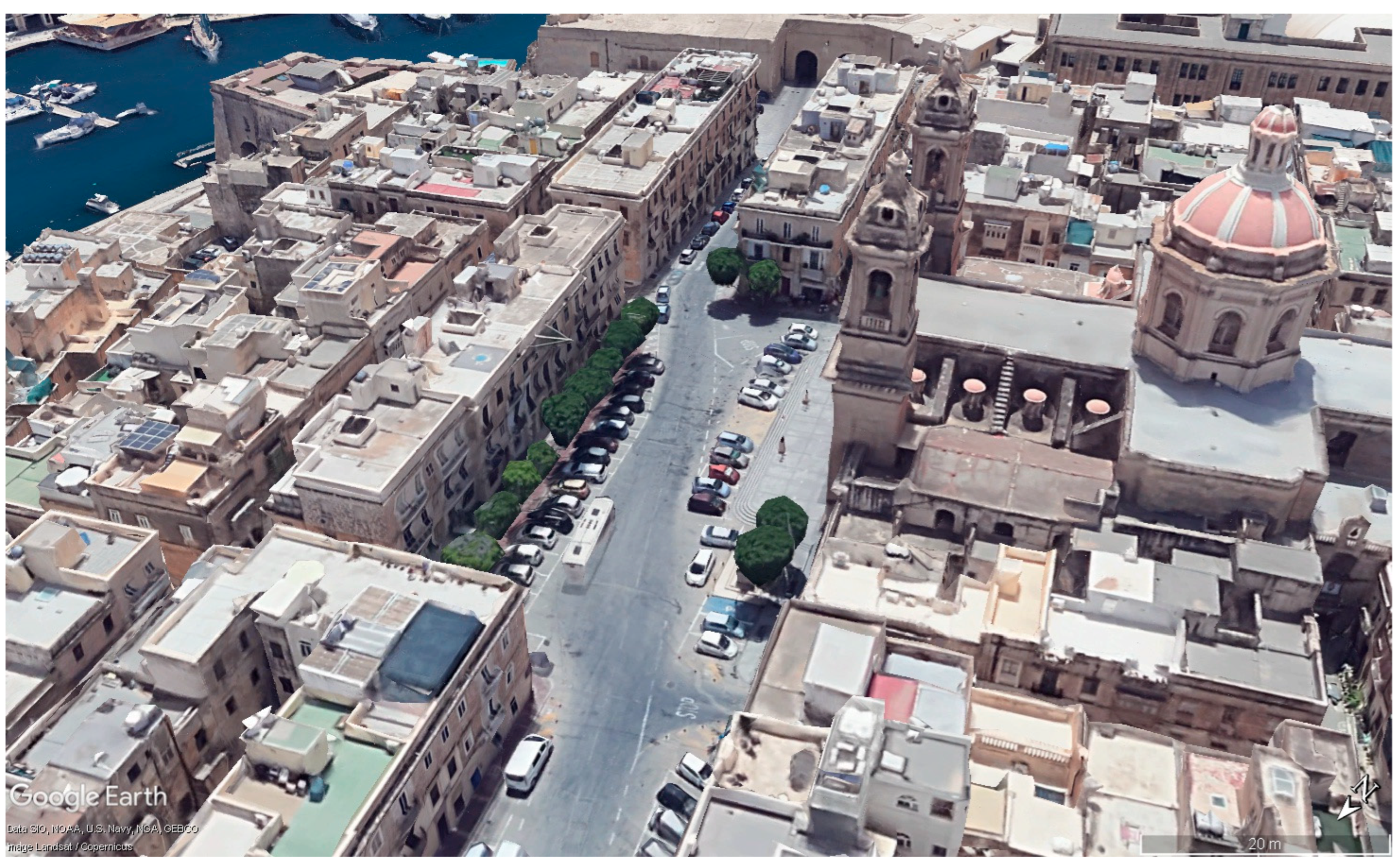
Location Red 1 (LR1), indicated in Figure 1, corresponds to Misraħ il-Papa Benedettu XV. The public square is situated opposite the main church, immediately beyond the entrance to the ramparts surrounding Isla. The site functions as a junction within the urban street network. The principal intersecting road, Triq il-Vitorja, is regularly served by bus routes to the town center and includes several on-street parking spaces. The measurements were conducted beneath the trees surrounding the public square (Figure 2).
Figure 2.
Aerial view of Misraħ il-Papa Benedettu XV, identified as Location Red 1 (LR1), 2022. Image from Google Earth [56]. Data: © Google, SIO, NOAA, U.S. Navy, NGA, GEBCO. Images: Landsat/Copernicus.
2.3.2. Misraħ l-Erbgħa ta’ Settembru, Triq il-Vitorja (35°53′15.7″ N 14°31′01.4″ E)
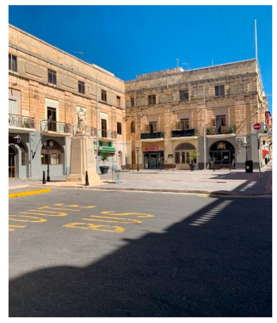
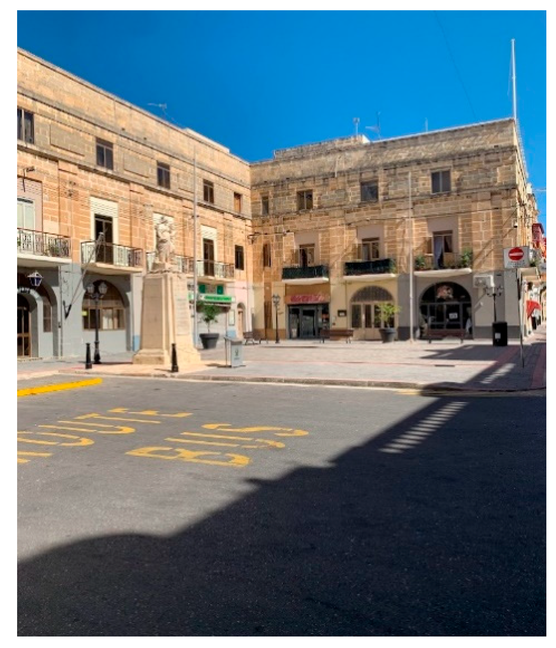
Location Red 2 (LR2), indicated in Figure 1, corresponds to Misraħ l-Erbgħa ta’ Settembru. The public square is located in the town center and serves as the terminal for all bus routes to Isla. In the past, the entire forecourt was used as a parking area; however, it has since been partially converted into a pedestrian zone surrounded by local businesses and market activities (Figure 3). The measurements were conducted adjacent to the main statue.
Figure 3.
Ground-level view of Misraħ l-Erbgħa ta’ Settembru, identified as Location Red 2 (LR2), 2022.
2.3.3. Parking Lot, Junction of Triq il-Monsinjur Panzavecchia and Triq il-31 ta’ Marzu (35°52′59.8″ N 14°31′08.7″ E)
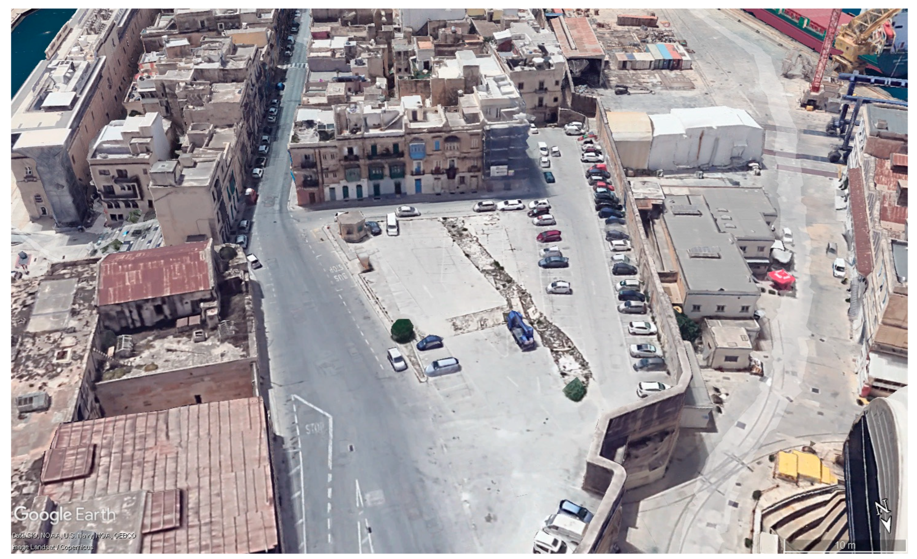
Location Purple Arrow (LPA), indicated in Figure 1, corresponds to the parking area at the junction of Triq il-Monsinjur Panzavecchia and Triq il-31 ta’ Marzu. The site is located immediately outside the entrance to the fortifications surrounding Isla. In 2016, the asphalt surface of the clearing was intact and fully serviceable, although vegetation was almost entirely absent. As of 2022, the pavement is severely deteriorated, with weeds and shrubs growing from the ground (Figure 4). Consequently, the space is used inefficiently and is unsafe for both people and vehicles to cross. The bus stop located along the adjacent road inevitably generates pedestrian transit within the area. The measurements were conducted as centrally as possible.
Figure 4.
Aerial view of the clearing identified as Location Purple Arrow (LPA), 2022. Image from Google Earth [56]. Data: © Google, SIO, NOAA, U.S. Navy, NGA, GEBCO. Images: Landsat/Copernicus.
3. Results
All parameters recorded over the 15 days are presented in Table 2 and Table 3 for both Misraħ il-Papa Benedettu XV and Misraħ l-Erbgħa ta’ Settembru, and in Table 4 for the Purple Arrow location, along with the corresponding sampling day and time. The recorded values for each parameter represent the average measured over the established one-minute time interval.
Table 2.
Meteorological parameters collected in LR1.
Table 3.
Meteorological parameters collected in LR2.
Table 4.
Meteorological parameters collected in LPA.
3.1. Data Collected in LR1 and LR2
Temperature, wind speed and humidity variations over the study period for both LR1 and LR2 are reported in Table 5. Descriptive statistics indicated a mean temperature of 32.18 °C (±0.72 °C) at LR1, and 32.67 °C (±1.00 °C) at LR2. The wind speed ranged from 0 to 10 km/h (mean 2.52 km/h ± 2.85 km/h) at LR1 and from 0 to 8.4 km/h (mean 1.41 km/h ± 2.01 km/h) at LR2. The relative humidity varied between 45.3% and 59.8% at LR1 (mean 51.24% ± 4.40%) and between 42.4% and 59.9% at LR2 (mean 51.21% ± 4.64%).
Table 5.
Descriptive statistics for LR1 and LR2.
In general, the datasets showed similar average conditions, although some differences emerged in the wind speed distribution and humidity variability. Wind speed exhibited a higher skewness coefficient in LR2 (3.39) compared to LR1 (1.32), indicating a less homogeneous distribution characterized by occasional higher values. The ranges also differed, with the LR2 area having a smaller range (8.4) than the LR1 area.
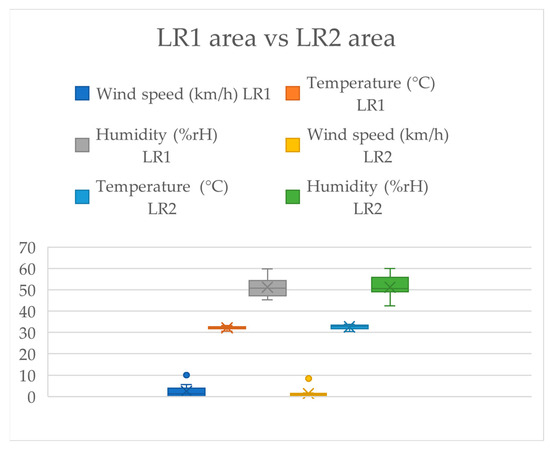
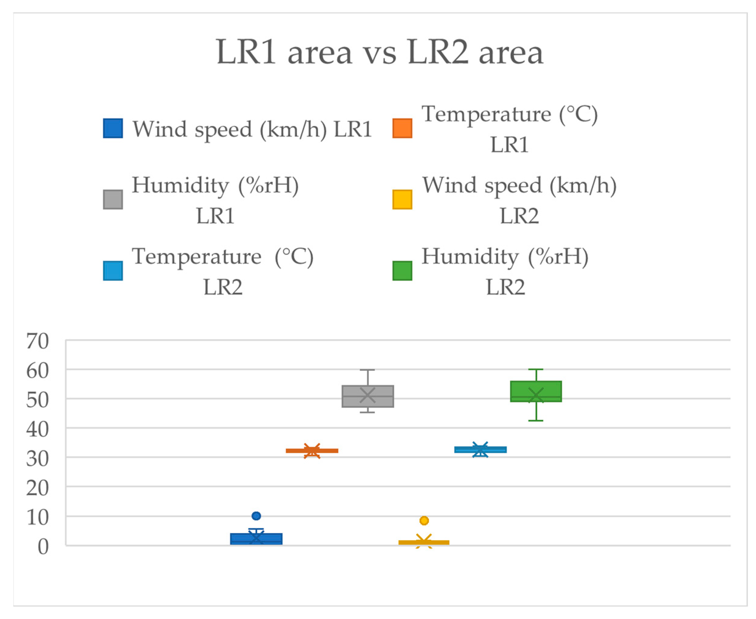
The boxplots presented in Figure 5 illustrate the variability of the monitored parameters (Table 5). Outliers were observed only in the wind speed data, while temperature distributions appeared to be relatively similar between the two sites. Regarding humidity, differences between the distributions were observed in the two sites. In LR2, higher variability was identified between the minimum value and the lower quartile, suggesting a less homogeneous humidity distribution compared to LR1.
Figure 5.
Box plot for LR1 zone area and LR2 zone area.
Given the non-normal distribution observed for wind speed, as confirmed by the Shapiro–Wilk test (Table 6), the Mann–Whitney U test was applied. The results showed p-values above 0.05 for all monitored variables, indicating no statistically significant differences between LR1 and LR2. To further explore the relationship between the air temperature and the recorded environmental variables, an MLR analysis was additionally performed (Table 7). Model M2 (referred to LR2) showed statistical significance (p = 0.017), whereas model M1 (referred to LR1) was not statistically significant (p = 0.160).
Table 6.
Test of normality (Shapiro–Wilk).
Table 7.
Multiple Linear Regression.
3.2. Data Collected in Location Purple Arrow (LPA)
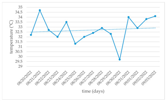
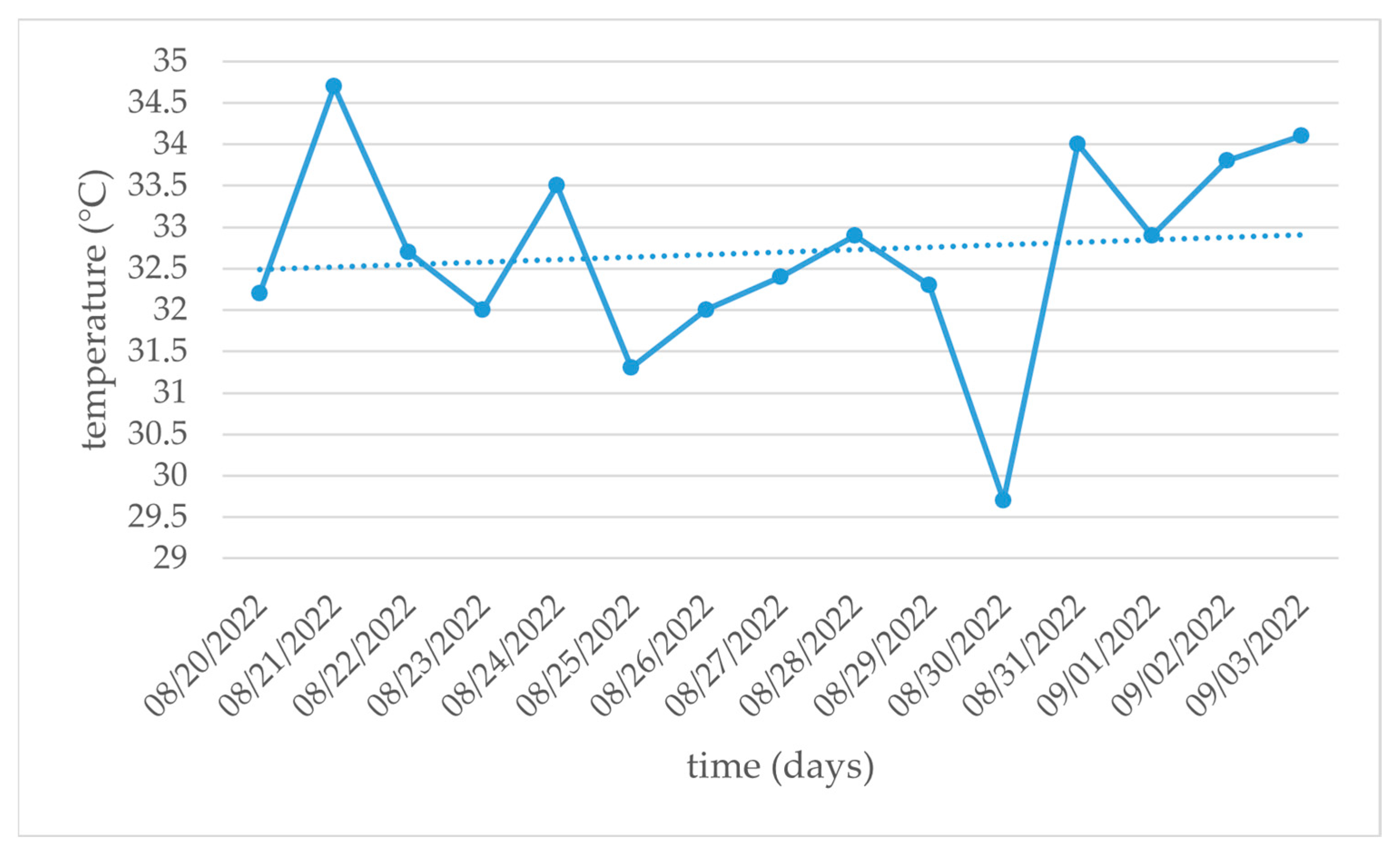
The LPA site was analyzed individually to identify areas of high thermal exposure. The mean temperature recorded over 15 days was 32.7 °C (±1.25 °C), with a minimum of 29.7 °C and a maximum of 34.7 °C (Figure 6). The wind speed at LPA ranged from 0.3 to 5.8 km/h (mean 3.7 km/h ± 1.85 km/h), and the relative humidity ranged from 44.3% to 61.8% (mean 51.12% ± 5.17%).
Figure 6.
The 15-day temperature values collected in LPA. The solid line represents the measured temperature values, while the dotted line indicates the linear trendline of the recorded data.
4. Discussion
Urban heat mitigation in compact Mediterranean cities represents a growing challenge due to increasing summer temperatures, high impervious surface coverage, and limited availability of green areas. In this context, urban planning is a powerful tool for climate change mitigation [57], as the functional interaction between buildings orientation, microclimatic conditions, urban compactness, and green space availability enables the development of sustainable urban models. NbS are increasingly recognized as promising strategies to improve urban resilience and outdoor thermal comfort.
Specifically, Malta embraced the concepts of green infrastructure and NbS through several governmental policies aimed at preserving local biodiversity [58,59,60]. However, from the research conducted by Balzan M. V et al. [61], it was discovered that although it emerged that recent policies and public funding promoted NbS adoption at a national scale, implementation constraints and institutional limitations still hinder urban planning mechanisms and community awareness.
In this context, the findings of the present study contribute site-specific microclimatic evidence supporting the potential role of NbS integration within the Maltese urban environment. The applied methodology refers to near-surface measurements acquired at approximately 2 m above ground level, consistent with common practices in urban microclimate field studies based on portable monitoring equipment [62,63].
Results from the comparison between LR1 and LR2 indicated that the vegetated site (LR1) exhibited slightly lower average air temperatures (~0.5 °C) compared to the non-vegetated area (LR2), although the difference was not statistically significant according to the Mann–Whitney U test. Similar moderate cooling effects associated with urban vegetation have been reported in Mediterranean and European urban environments [64,65].
Beyond average temperature differences, the statistical analysis suggested distinct microclimatic responses between the two investigated sites. The wind speed distribution in LR2 exhibited a markedly higher skewness coefficient compared to LR1, indicating greater variability and the occurrence of occasional higher wind speed values. Differences were also observed in humidity distribution patterns between the two locations. The Multiple Linear Regression analysis further highlighted these differences. In LR2, the statistically significant regression model (p = 0.017) suggests that short-term variations in wind speed and relative humidity were significantly associated with local air temperature variability during the monitoring period. Conversely, the non-significant regression model observed in LR1 suggests that additional site-specific factors, potentially including vegetation shading and localized urban morphology, may contribute to moderating the temperature variability beyond the influence of wind speed and humidity alone.
The behavior observed in LR2 may be associated with the greater exposure of non-vegetated urban space to atmospheric variability and the absence of buffering elements that are capable of stabilizing local thermal conditions. Moreover, air temperatures recorded in LPA further suggest the sensitivity of large, cleared, and impervious urban areas to heat accumulation and thermal exposure. Consequently, planning green interventions aimed at increasing vegetation coverage and improving spatial permeability may contribute to reducing local vulnerability and rebalancing the ratio between green and gray surfaces within the urban fabric of Isla.
As a compact urban area characterized by a high population density, Isla exhibits a clear need for ecosystem service restoration [66]. In this context, the integration of NbS represents a strategic approach to improve urban resilience. Given their multifunctionality, the combination of NbS and conventional engineering solutions may simultaneously address a wide range of environmental challenges across multiple sectors [67,68,69].
4.1. Nature-Based Solutions Scenario for LR2
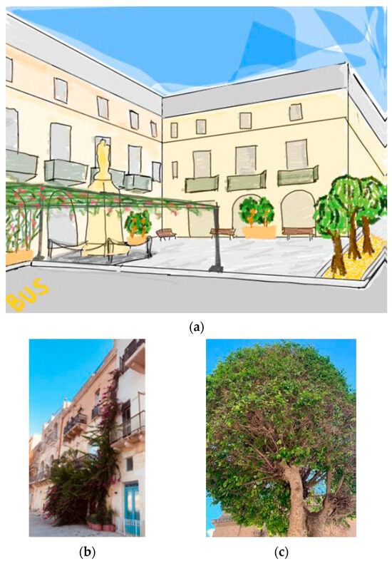
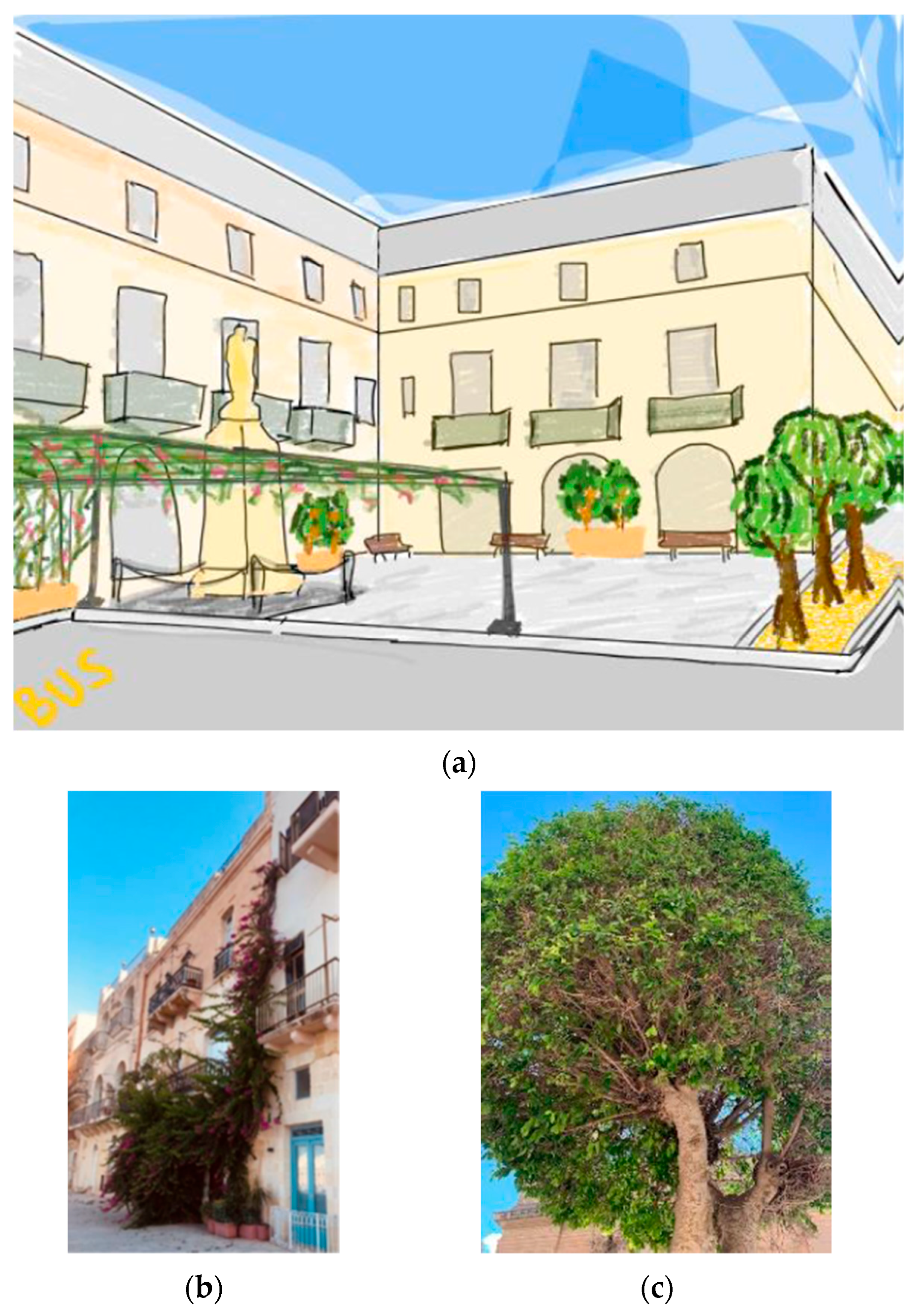
Based on the observed microclimatic behavior of LR2, the proposed interventions aim to improve thermal regulation by increasing vegetation coverage and introducing additional shading elements within the public space. The NbS, illustrated in Figure 7, were designed to compensate for the limited presence of green elements while remaining compatible with the spatial and functional constraints of the area.
Figure 7.
(a) The designed Nature-based Solutions scenario for LR2 regeneration, (b) the plant species selected for the site-specific implementation of the green canopy (the climbing species of Bougainvillea) and (c) the street trees (the Ficus).
The scarce vegetation, hardly visible in Figure 3, could be reinforced through the introduction of a single row of trees along the sidewalk parallel to the main road (Figure 7). The resulting shading would extend over both the on-street parking spaces and the open clearing, depending on the position of the sun. In addition, the pedestrian area would be further delineated, creating a visual and spatial buffer between the road and the public square. To ensure landscape continuity and preserve local biodiversity (including both flora and fauna), it is crucial to select autochthonous species or plants that are already adapted to the site-specific microclimate. An example is Ficus, belonging to the Moraceae family (Figure 7). Ficus species may assume tree, arboreal or climbing forms. Native to the Middle East [70] and widely cultivated in the Mediterranean basin, Ficus prefers a warm and humid climate and demonstrates resistance to heat stress [71].
Although not explicitly classified among the NbS listed in Table 1, the term “green canopy” is here used to describe a vegetated shelter integrating natural elements with an architectural support structure (Figure 7), potentially even constructed from natural materials such as wood, in line with the concept of living plant architecture. In this case study, the most feasible option would consist of an artificial supporting structure for climbing vegetation, due to spatial constraints and the proximity of surrounding buildings. Suitable climbing species include Ficus pumila (Moraceae), Bougainvillea (Nyctaginaceae), a tropical plant (Figure 7) that is capable of surviving in semi-arid and saline conditions, therefore adaptable to irrigation with low-quality water [72], and Jasminoides or Hedera, which are commonly employed in Mediterranean contexts for vertical greening due to their potential contribution to UHI mitigation [73].
The historical and cultural heritage of Isla restricts the implementation of permanent installations within the central area of the clearing, which frequently hosts public events and local festivities.
4.2. Nature-Based Solutions Scenario for LPA
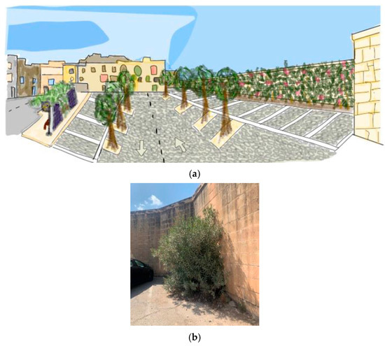
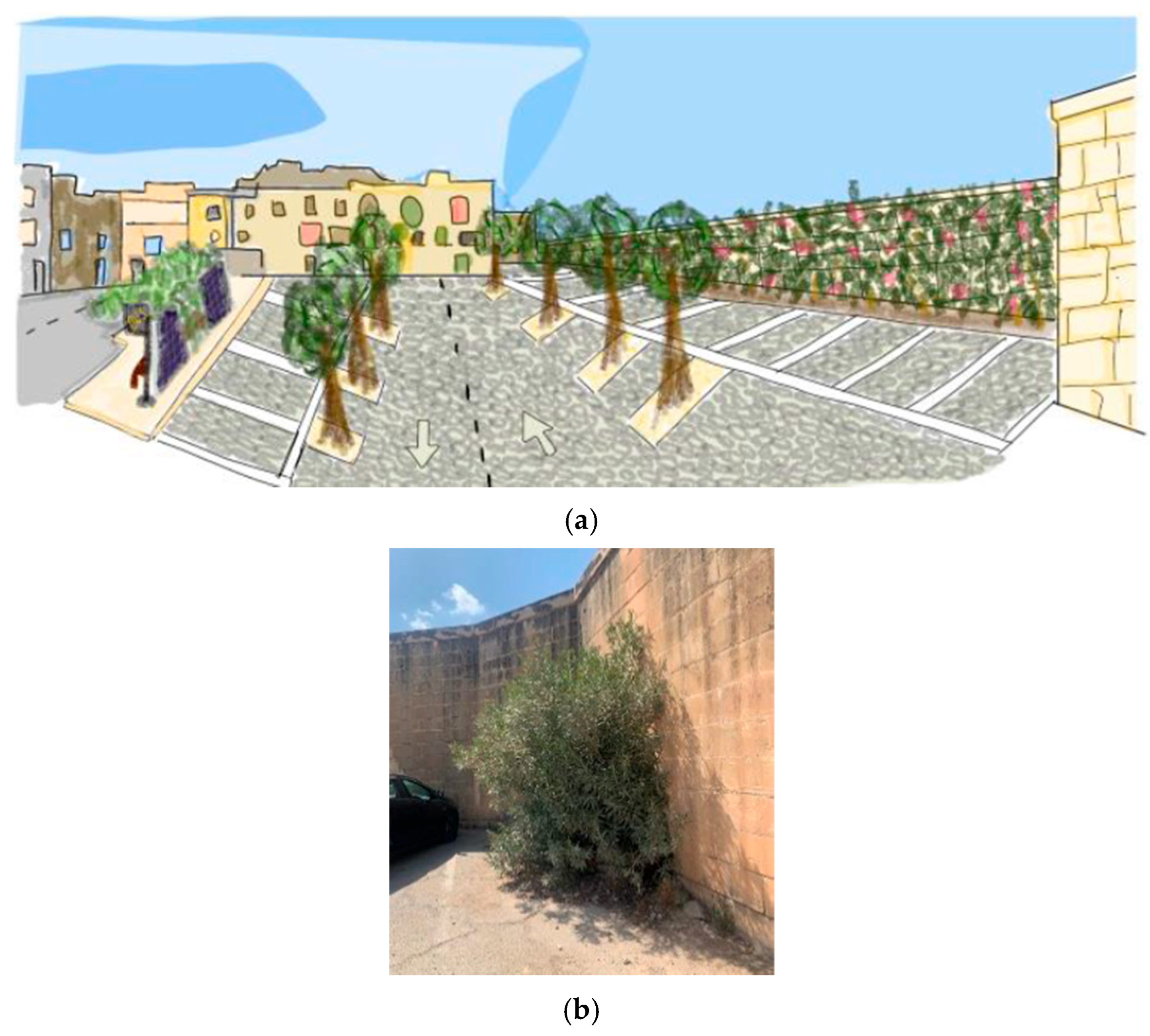
Several alternative spatial configurations may be considered for the available area; Figure 8 schematically illustrates the layout proposed by the authors.
Figure 8.
(a) The designed Nature-based Solutions scenario for LPA regeneration, and (b) the plant species selected for the site-specific implementation of the ground-based green wall system (Oleander).
The extensive wall delimiting the parking area offers the opportunity to implement a ground-based green wall system. A climate-resilient plant species commonly employed in Mediterranean urban landscaping is Oleander [74], which already grows as spontaneous shrub vegetation within the parking clearing (Figure 8). Additional species that were previously discussed may also be considered.
The presence of the bus stop inevitably generates a continuous flow of pedestrians crossing the clearing. Moreover, the parking lot is located within reasonable walking distance of different city centers. Although primarily functioning as a transit space, the area lacks adequate shading, particularly near the public transport waiting zone. For these reasons, the replacement of the existing bus stop with a shelter incorporating an extensive green roof is proposed, with the aim of providing environmental benefits and thermal comfort. Such installations can be effectively integrated with photovoltaic panels [75], potentially generating sufficient energy to power charging stations for electronic devices, possibly embedded within seating elements, e.g., benches [76].
Previous studies have examined the contribution of various cool pavement typologies to UHI mitigation [77,78,79]. For this case study, deteriorated asphalt is proposed to be replaced with permeable pavement, which is capable of reducing surface solar radiation reflectance, thereby mitigating high temperatures and improving growth conditions for vegetation by supporting deeper root development [40]. Permeable pavements are NbS typically implemented for water management purposes due to their efficient performance in reducing runoff volumes compared to impervious surfaces [80]. Nevertheless, within the scope of this study, they exemplify NbS multifunctionality in addressing multiple climate-related challenges simultaneously.
The introduction of street trees is again proposed as a NbS for high-temperature mitigation, due to their evapotranspiration capacity and shading effects [81]. In this area, trees could be interspaced with parking spaces to prevent excessive indoor vehicle temperatures during summer. As in the case of LR2, careful species selection is crucial to ensure sustainable resource management (an appropriate example remains Ficus from the Moraceae family).
4.3. Limitations to the Study
The monitoring campaign covered a relatively short time window (15 days), selected to coincide with late summer conditions when Mediterranean temperatures typically reach their annual peak. In fact, according to official meteorological summaries for Malta, the highest daily maximum air temperature recorded in 2022 was reached in August (~39.2 °C) [24]. While this period provides a representative snapshot of the microclimatic conditions associated with maximum urban heat stress, it does not capture inter-seasonal variability or longer-term climatic fluctuations. Consequently, the findings should be interpreted primarily as an indication of local summer microclimatic behavior, rather than as a comprehensive annual assessment.
Short-term meteorological variability, including fluctuations in wind speed and relative humidity during the monitoring period, likely contributed to the observed microclimatic dynamics between sites. Although these parameters were integrated into the statistical analysis through MLR models, the relatively limited monitoring duration and the sequential acquisition of measurements may still influence the interpretation of inter-site thermal variability.
In addition to these environmental factors, instrumentation-related constraints should also be considered. Using a portable anemometer that is not equipped with a standardized radiation shield, particularly under high irradiance conditions that are typical of a Mediterranean summer climate, may influence the sensor efficiency.
Although the air temperature represented the primary indicator used to evaluate localized heat exposure, wind speed and relative humidity were also integrated into the statistical framework to support the interpretation of the observed microclimatic variability. Nevertheless, future studies including longer monitoring periods, seasonal datasets, and thermal comfort indices could further refine the assessment of outdoor microclimatic performance within the Maltese urban context.
Another important aspect concerns the scale of the applicability of the findings. The study was designed as a site-specific microclimatic assessment within the compact urban fabric of Isla. Therefore, the results cannot be directly generalized to other urban contexts without considering differences in morphology, vegetation structure, and local climatic conditions. Nevertheless, the observed microclimatic patterns associated with vegetated and non-vegetated areas are consistent with findings reported in other Mediterranean and European cities, supporting the relevance of vegetation-based interventions as part of urban heat mitigation strategies.
Finally, the Nature-based Solutions scenarios proposed for LR2 and LPA should be interpreted as site-specific planning strategies grounded in empirical observations collected during the monitoring campaign and supported by the existing literature on the thermal mitigation potential of urban vegetation. Although the present research does not include microclimatic simulations, previous studies have demonstrated that urban greening strategies may contribute to measurable reductions in localized heat exposure and improvements in outdoor thermal comfort conditions. Therefore, future research integrating field monitoring and simulation-based modeling could further refine the quantitative assessment of the proposed interventions.
5. Conclusions
This study assessed the microclimatic conditions of multiple urban locations in Isla through on-site measurements of air temperature, relative humidity, and wind speed. The reported analysis combined a paired comparison between vegetated and non-vegetated areas with the examination of an additional gray site characterized by specific spatial configurations. The results revealed slightly lower average temperatures within the vegetated site (LR1), although the observed differences were not statistically significant according to the Mann–Whitney U test. However, the statistical analysis highlighted distinct microclimatic responses between the investigated sites. In particular, the MLR models suggested that non-vegetated areas were more sensitive to the short-term atmospheric variability associated with wind speed and relative humidity fluctuations. Additional observations from other monitored locations confirmed the vulnerability of large impervious areas to summer heat exposure. These findings support the hypothesis that urban vegetation may contribute not only to localized cooling, but also to increased microclimatic stability within compact Mediterranean urban environments by reducing the sensitivity of near-surface thermal conditions to short-term atmospheric fluctuations.
From an urban planning perspective, the study highlights the potential contribution of NbS to improve urban microclimatic conditions in compact Mediterranean cities. The design scenarios proposed for LR2 and LPA illustrate how targeted interventions, such as increased tree cover and the reduction in impervious surfaces, may contribute to rebalancing the proportion between green and gray infrastructure while simultaneously supporting outdoor thermal comfort and ecosystem service restoration.
The results of this study are derived from a relatively short monitoring period (15 days) and do not include simulation-based modeling of the proposed NbS; therefore, they do not represent the full seasonal variability of the local climate. Consequently, the findings should be interpreted as exploratory field-based evidence, rather than comprehensive predictive assessments of long-term urban thermal behavior. Future research could expand the monitoring duration, integrate additional thermal comfort indicators, and combine field observations with simulation-based approaches to further quantify the cooling performance of site-specific NbS configurations.
Despite these limitations, the methodological approach adopted in this research provides a replicable framework for rapid microclimatic assessment in small urban areas and offers targeted and context-sensitive insights for Isla that may support broader urban planning strategies aimed at enhancing climate resilience in other compact Mediterranean cities.
Author Contributions
M.E.B.: Conceptualization, methodology, investigation, design, and writing of original draft. A.B.: Conceptualization, methodology, review, editing and validation. M.V.B.: Conceptualization, resources, review and editing. All authors have read and agreed to the published version of the manuscript.
Funding
This research received no external funding.
Data Availability Statement
The original contributions presented in this study are included in the article. Further inquiries can be directed to the corresponding author.
Acknowledgments
The authors would like to sincerely thank Andromeda Pătrașcu Sonea from the “Ion Ionescu de la Brad” Iasi University of Life Sciences for her valuable support and contribution to the statistical analysis conducted in this study.
Conflicts of Interest
Author M.V.B. is a shareholder and director of Ecostack Innovations Limited. The remaining authors declare that the research was conducted in the absence of any commercial or financial relationships that could be construed as a potential conflict of interest.
Abbreviations
The following abbreviations are used in this manuscript:
| NbS | Nature-based Solutions |
| UHI | Urban Heat Island |
| LR1 | Location Red 1 |
| LR2 | Location Red 2 |
| LPA | Location Purple Arrow |
| IPCC | Intergovernmental Panel on Climate Change |
| VOC | Volatile Organic Compounds |
| NOx | Nitrogen Oxides |
| MLR | Multiple Linear Regression |
References
- European Commission Urbanisation in Europe. European Commission—Knowledge for Policy. Available online: https://knowledge4policy.ec.europa.eu/foresight/topic/continuing-urbanisation/urbanisation-europe_en#:~:text=Europe’s%20level%20of%20urbanisation%20is,a%20smooth%20and%20constant%20increase (accessed on 15 February 2024).
- Gherri, B. The Role of Urban Vegetation in Counteracting Overheating in Different Urban Textures. Land 2023, 12, 2100. [Google Scholar] [CrossRef] [Scilit]
- Ibrahim, S.H.; Ibrahim, N.I.A.; Wahid, J.; Goh, N.A.; Koesmeri, D.R.A.; Nawi, M.N.M. The Impact of Road Pavement on Urban Heat Island (UHI) Phenomenon. Int. J. Technol. 2018, 9, 1597–1608. [Google Scholar] [CrossRef] [Scilit]
- IPCC. 2023: Climate Change 2023: Synthesis Report. Contribution of Working Groups I, II and III to the Sixth Assessment Report of the Intergovernmental Panel on Climate Change; Core Writing Team, Lee, H., Romero, J., Eds.; IPCC: Geneva, Switzerland, 2023; 184p. [Google Scholar]
- De Biase, M.; Chidichimo, F.; Maiolo, M.; Micallef, A. The Impact of Predicted Climate Change on Groundwater Resources in a Mediterranean Archipelago: A Modelling Study of the Maltese Islands. Water 2021, 13, 3046. [Google Scholar] [CrossRef] [Scilit]
- Colelli, F.P.; Emmerling, J.; Marangoni, G.; Mistry, M.N.; De Cian, E. Increased Energy Use for Adaptation Significantly Impacts Mitigation Pathways. Nat. Commun. 2022, 13, 4964. [Google Scholar] [CrossRef] [Scilit]
- Dewan, S.; Lakhani, A. Tropospheric Ozone and Its Natural Precursors Impacted by Climatic Changes in Emission and Dynamics. Front. Environ. Sci. 2022, 10, 1007942. [Google Scholar] [CrossRef] [Scilit]
- Briciu, A.E.; Mihăilă, D.; Oprea, D.I.; Prisăcariu, A. Urban Stream Temperature Surge—Streamwater Temperature Variability after Rainfall in Suceava City Metropolitan Area. Sustainability 2023, 15, 7882. [Google Scholar] [CrossRef] [Scilit]
- IPCC. 2022: Climate Change 2022: Impacts, Adaptation and Vulnerability. Contribution of Working Group II to the Sixth Assessment Report of the Intergovernmental Panel on Climate Change; Pörtner, H.-O., Roberts, D.C., Tignor, M., Poloczanska, E.S., Mintenbeck, K., Alegría, A., Craig, M., Langsdorf, S., Löschke, S., Möller, V., et al., Eds.; Cambridge University Press: Cambridge, UK; New York, NY, USA, 2022; 3056p. [Google Scholar]
- Katsoulis, B.D.; Makrogiannis, T.J.; Goutsidou, Y.A. Monthly Anticyclonicity in Southern Europe and the Mediterranean Region. Theor. Appl. Climatol. 1998, 59, 51–59. [Google Scholar] [CrossRef] [Scilit]
- Ahmed Memon, R.; Leung, D.Y.; Chunho, L. A Review on the Generation, Determination and Mitigation of Urban Heat Island; Elsevier: Amsterdam, The Netherlands, 2008; Volume 20. [Google Scholar]
- Anjos, M.; Targino, A.C.; Krecl, P.; Oukawa, G.Y.; Braga, R.F. Analysis of the Urban Heat Island under Different Synoptic Patterns Using Local Climate Zones. Build. Environ. 2020, 185, 107268. [Google Scholar] [CrossRef] [Scilit]
- Kassomenos, P.; Kissas, G.; Petrou, I.; Begou, P.; Khan, H.S.; Santamouris, M. The Influence of Daily Weather Types on the Development and Intensity of the Urban Heat Island in Two Mediterranean Coastal Metropolises. Sci. Total Environ. 2022, 819, 153071. [Google Scholar] [CrossRef] [Scilit] [PubMed]
- Drobinski, P.; Bastin, S.; Arsouze, T.; Béranger, K.; Flaounas, E.; Stéfanon, M. North-Western Mediterranean Sea-Breeze Circulation in a Regional Climate System Model. Clim. Dyn. 2018, 51, 1077–1093. [Google Scholar] [CrossRef] [Scilit]
- Shi, Y.; Zhang, Y. Urban Morphological Indicators of Urban Heat and Moisture Islands under Various Sky Conditions in a Humid Subtropical Region. Build. Environ. 2022, 214, 108906. [Google Scholar] [CrossRef] [Scilit]
- Yang, J.; Zhao, L.; Oleson, K. Large Humidity Effects on Urban Heat Exposure and Cooling Challenges under Climate Change. Environ. Res. Lett. 2023, 18, 044024. [Google Scholar] [CrossRef] [Scilit]
- Huang, X.; Song, J.; Wang, C.; Chui, T.F.M.; Chan, P.W. The Synergistic Effect of Urban Heat and Moisture Islands in a Compact High-Rise City. Build. Environ. 2021, 205, 108274. [Google Scholar] [CrossRef] [Scilit]
- Kleerekoper, L.; Van Esch, M.; Salcedo, T.B. How to Make a City Climate-Proof, Addressing the Urban Heat Island Effect. Resour. Conserv. Recycl. 2012, 64, 30–38. [Google Scholar] [CrossRef] [Scilit]
- Peng, S.; Kon, Y.; Watanabe, H. Effects of Sea Breeze on Urban Areas Using Computation Fluid Dynamic—A Case Study of the Range of Cooling and Humidity Effects in Sendai, Japan. Sustainability 2022, 14, 1074. [Google Scholar] [CrossRef] [Scilit]
- National Statistics Office Malta World Population Day: 11 July 2023. Available online: https://nso.gov.mt/world-population-day-11-july-2023/ (accessed on 15 February 2024).
- Jahan, S.; Cauchi, J.P.; Galdies, C.; Wraith, D. Effects of Ambient Temperatures and Extreme Weather Events on Circulatory Mortality in a High Population Density Area: Exploring Mortality Data from Malta. Clim. Risk Manag. 2022, 38, 100463. [Google Scholar] [CrossRef] [Scilit]
- Malta Resources Authority on Behalf of the Ministry for Environment Energy and Enterprise. Malta’s Fifth Biennial Report. The Fifth Biennial Report of Malta Under the United Nations Framework Convention on Climate Change; Malta Resources Authority: Marsa, Malta, 2023. [Google Scholar]
- Malta International Airport Malta International Airport—Weather. Available online: https://www.maltairport.com/weather/ (accessed on 15 March 2024).
- Times of Malta 2022 Was the Second-Driest Year of the Past Decade. Available online: https://timesofmalta.com/article/2022-seconddriest-year-past-decade.1007140?utm (accessed on 17 March 2026).
- Charles, G. The Climate of Malta: Statistics, Trends and Analysis 1951–2010; National Statistics Office: Il-Belt Valletta, Malta, 2011; ISBN 9789995729196. [Google Scholar]
- Scicluna, J. The Urban Heat Island Effect in Malta and the Adequacy of Green Roofs in Its Mitigation. 2016. Available online: https://www.um.edu.mt/library/oar/handle/123456789/18840 (accessed on 16 January 2023).
- Ambrosetti, E. Demographic Challenges in the Mediterranean; MED: Amsterdam, The Netherlands, 2020. [Google Scholar]
- Doignon, Y.; Blöss-Widmer, I.; Ambrosetti, E.; Oliveau, S. Population Dynamics in the Mediterranean—A Demographic Convergence? Springer: Cham, Switzerland, 2023. [Google Scholar]
- Beaugeard, E.; Brischoux, F.; Angelier, F. Green Infrastructures and Ecological Corridors Shape Avian Biodiversity in a Small French City. Urban Ecosyst. 2021, 24, 549–560. [Google Scholar] [CrossRef] [Scilit]
- García-Nieto, A.P.; Geijzendorffer, I.R.; Baró, F.; Roche, P.K.; Bondeau, A.; Cramer, W. Impacts of Urbanization around Mediterranean Cities: Changes in Ecosystem Service Supply. Ecol. Indic. 2018, 91, 589–606. [Google Scholar] [CrossRef] [Scilit]
- Leitão, I.A.; Ferreira, C.S.S.; Ferreira, A.J.D. Assessing Long-Term Changes in Potential Ecosystem Services of a Peri-Urbanizing Mediterranean Catchment. Sci. Total Environ. 2019, 660, 993–1003. [Google Scholar] [CrossRef] [Scilit]
- Balzan, M.V.; Caruana, J.; Zammit, A. Assessing the Capacity and Flow of Ecosystem Services in Multifunctional Landscapes: Evidence of a Rural-Urban Gradient in a Mediterranean Small Island State. Land Use Policy 2018, 75, 711–725. [Google Scholar] [CrossRef] [Scilit]
- Casagrande, D.; Vasquez, M. Restoring for cultural-ecological sustainability in Arizona and Connecticut. In Restoration and History: The Search for a Usable Environmental Past; Routledge: London, UK, 2009. [Google Scholar]
- Sarabi, S.; Frantzeskaki, N.; Waldenberger, J.; Alvarado, O.; Raaimakers, D.; Runhaar, H.; Stijnen, C.; Toxopeus, H.; Vrînceanu, E. Renaturing Cities: From Utopias to Contested Realities and Futures. Urban For. Urban Green. 2023, 86, 127999. [Google Scholar] [CrossRef] [Scilit]
- Alves, A.; van Opstal, C.; Keijzer, N.; Sutton, N.; Chen, W.S. Planning the Multifunctionality of Nature-Based Solutions in Urban Spaces. Cities 2024, 146, 104751. [Google Scholar] [CrossRef] [Scilit]
- European Environment Agency. Nature-Based Solutions in Europe: Policy, Knowledge and Practice for Climate Change Adaptation and Disaster Risk Reduction; European Environment Agency: Copenhagen, Denmark, 2021. [Google Scholar] [CrossRef]
- Cohen-Shacham, E.; Walters, G.; Janzen, C.; Maginnis, S. Nature-Based Solutions to Address Global Societal Challenges; IUCN International Union for Conservation of Nature: Gland, Switzerland, 2016. [Google Scholar]
- Connop, S.; Vandergert, P.; Eisenberg, B.; Collier, M.J.; Nash, C.; Clough, J.; Newport, D. Renaturing Cities Using a Regionally-Focused Biodiversity-Led Multifunctional Benefits Approach to Urban Green Infrastructure. Environ. Sci. Policy 2016, 62, 99–111. [Google Scholar] [CrossRef] [Scilit]
- Qin, Y.; Ghalambaz, S.; Sheremet, M.; Baro, M.; Ghalambaz, M. Deciphering Urban Heat Island Mitigation: A Comprehensive Analysis of Application Categories and Research Trends. Sustain. Cities Soc. 2024, 101, 105081. [Google Scholar] [CrossRef] [Scilit]
- Eisenberg, B.; Chiesa, C.; Fischer, L.K.; Jakstis, K.; Polcher, V.; Schwarz, H.-G. Nature-Based Solutions—Technical Handbook Factsheets; UNaLab NBS: Brussels, Belgium, 2022. [Google Scholar]
- Xi, C.; Han, L.; Wang, J.; Feng, Z.; Kumar, P.; Cao, S.J. How Can Greenery Space Mitigate Urban Heat Island? An Analysis of Cooling Effect, Carbon Sequestration, and Nurturing Cost at the Street Scale. J. Clean. Prod. 2023, 419, 138230. [Google Scholar] [CrossRef] [Scilit]
- Hayes, A.T.; Jandaghian, Z.; Lacasse, M.A.; Gaur, A.; Lu, H.; Laouadi, A.; Ge, H.; Wang, L. Nature-Based Solutions (NBSs) to Mitigate Urban Heat Island (UHI) Effects in Canadian Cities. Buildings 2022, 12, 925. [Google Scholar] [CrossRef] [Scilit]
- Virtudes, A. Benefits of Greenery in Contemporary City. IOP Conf. Ser. Earth Environ. Sci. 2016, 44, 032020. [Google Scholar] [CrossRef] [Scilit]
- Barker, A.; Felliu, E.; Garcia-Blanco, G.; Kwiacinska, K.; Pedrola, B. Sustainability Assessment of Urban. In Nature-Based Solutions for More Sustainable Cities: A Framework Approach for Planning and Evaluation; Crocci, E., Lucchitta, B., Eds.; Emerald Publishing Limited: Leeds, UK, 2021; ISBN 9781800436367. [Google Scholar]
- Marucci, A.; Zullo, F.; Fiorini, L.; Saganeiti, L. Innovation in Urban and Regional Planning; Lecture Notes in Civil Engineering; Springer Nature: Cham, Switzerland, 2024. [Google Scholar]
- Su, J.; Wang, M.; Zhang, D.; Yuan, H.; Zhou, S.; Wang, Y.; Adib Mohammad Razi, M. Integrating Technical and Societal Strategies in Nature-Based Solutions for Urban Flood Mitigation in Guangzhou, a Heritage City. Ecol. Indic. 2024, 162, 112030. [Google Scholar] [CrossRef] [Scilit]
- Su, W.; Zhang, L.; Chang, Q. Nature-Based Solutions for Urban Heat Mitigation in Historical and Cultural Block: The Case of Beijing Old City. Build. Environ. 2022, 225, 109600. [Google Scholar] [CrossRef] [Scilit]
- Pacetti, T.; Cioli, S.; Castelli, G.; Bresci, E.; Pampaloni, M.; Pileggi, T.; Caporali, E. Planning Nature Based Solutions against Urban Pluvial Flooding in Heritage Cities: A Spatial Multi Criteria Approach for the City of Florence (Italy). J. Hydrol. Reg. Stud. 2022, 41, 101081. [Google Scholar] [CrossRef] [Scilit]
- Tzortzi, J.N.; Lux, M.S. Renaturing Historical Centres the Role of Private space in Milan’s Green Infrastructure. Int. J. Archit. Art Des. 2022, 11, 226–237. [Google Scholar] [CrossRef]
- Olivieri, F.; Sassenou, L.N.; Olivieri, L. Potential of Nature-Based Solutions to Diminish Urban Heat Island Effects and Improve Outdoor Thermal Comfort in Summer: Case Study of Matadero Madrid. Sustainability 2024, 16, 2778. [Google Scholar] [CrossRef] [Scilit]
- Jamei, E.; Rajagopalan, P.; Seyedmahmoudian, M.; Jamei, Y. Review on the Impact of Urban Geometry and Pedestrian Level Greening on Outdoor Thermal Comfort. Renew. Sustain. Energy Rev. 2016, 54, 1002–1017. [Google Scholar] [CrossRef] [Scilit]
- OpenStreetMap. Available online: https://www.openstreetmap.org/ (accessed on 16 January 2023).
- National Statistics Office Malta. Census of Population and Housing 2021: Final Report: Population, Migration and Other Social Characteristics; National Statistics Office Malta: Il-Belt Valletta, Malta, 2023; Volume 1. [Google Scholar]
- Tsoka, S.; Velikou, K.; Tolika, K.; Tsikaloudaki, A. Evaluating the Combined Effect of Climate Change and Urban Microclimate on Buildings’ Heating and Cooling Energy Demand in a Mediterranean City. Energies 2021, 14, 5799. [Google Scholar] [CrossRef] [Scilit]
- JDC Electronic SA Skywatch Atmos—Owner’s Instruction. Available online: https://www.jdc.ch/website/wp-content/uploads/2018/04/skywatch-atmos-owner-s-instructions.pdf (accessed on 18 January 2026).
- Google Earth. Available online: https://earth.google.com/web/ (accessed on 15 March 2024).
- Grifoni, R.C.; D’Onofrio, R.; Sargolini, M.; Pierantozzi, M. A Parametric Optimization Approach to Mitigating the Urban Heat Island Effect: A Case Study in Ancona, Italy. Sustainability 2016, 8, 896. [Google Scholar] [CrossRef] [Scilit]
- Ministry for Resources and Rural Affairs—Government of Malta. National Climate Change Adaptation Strategy; Ministry for Resources and Rural Affairs—Government of Malta: Marsa, Malta, 2012. [Google Scholar]
- Ministry for the Environment Energy and Enterprise—Government of Malta. National Strategy for the Environment 2050; Ministry for the Environment Energy and Enterprise—Government of Malta: Valletta, Malta, 2022. [Google Scholar]
- Environment and Resources Authority National Biodiversity Strategy and Action Plan to 2030; Ministry for Resources and Rural Affairs: Marsa, Malta, 2023.
- Balzan, M.V.; Geneletti, D.; Grace, M.; De Santis, L.; Tomaskinova, J.; Reddington, H.; Sapundzhieva, A.; Dicks, L.V.; Collier, M. Assessing Nature-Based Solutions Uptake in a Mediterranean Climate: Insights from the Case-Study of Malta. Nat.-Based Solut. 2022, 2, 100029. [Google Scholar] [CrossRef] [Scilit]
- Tsin, P.K.; Knudby, A.; Krayenhoff, E.S.; Ho, H.C.; Brauer, M.; Henderson, S.B. Microscale Mobile Monitoring of Urban Air Temperature. Urban Clim. 2016, 18, 58–72. [Google Scholar] [CrossRef] [Scilit]
- Rosso, F.; Pioppi, B.; Pisello, A.L. Pocket Parks for Human-Centered Urban Climate Change Resilience: Microclimate Field Tests and Multi-Domain Comfort Analysis through Portable Sensing Techniques and Citizens’ Science. Energy Build. 2022, 260, 111918. [Google Scholar] [CrossRef] [Scilit]
- Taleghani, M.; Marshall, A.; Fitton, R.; Swan, W. Renaturing a Microclimate: The Impact of Greening a Neighbourhood on Indoor Thermal Comfort during a Heatwave in Manchester, UK. Sol. Energy 2019, 182, 245–255. [Google Scholar] [CrossRef] [Scilit]
- Gómez, F.; Tamarit, N.; Jabaloyes, J. Green Zones, Bioclimatics Studies and Human Comfort in the Future Development of Urban Planning. Landsc. Urban Plan. 2001, 55, 151–161. [Google Scholar] [CrossRef] [Scilit]
- Longato, D.; Cortinovis, C.; Balzan, M.; Geneletti, D. A Method to Prioritize and Allocate Nature-Based Solutions in Urban Areas Based on Ecosystem Service Demand. Landsc. Urban Plan. 2023, 235, 104743. [Google Scholar] [CrossRef] [Scilit]
- Cristiano, E.; Annis, A.; Apollonio, C.; Pumo, D.; Urru, S.; Viola, F.; Deidda, R.; Pelorosso, R.; Petroselli, A.; Tauro, F.; et al. Multilayer Blue-Green Roofs as Nature-Based Solutions for Water and Thermal Insulation Management. Hydrol. Res. 2022, 53, 1129–1149. [Google Scholar] [CrossRef] [Scilit]
- Almeida, A.P.; Liberalesso, T.; Silva, C.M.; Sousa, V. Combining Green Roofs and Rainwater Harvesting Systems in University Buildings under Different Climate Conditions. Sci. Total Environ. 2023, 887, 163719. [Google Scholar] [CrossRef] [Scilit]
- Stark, J.; Plancke, Y.; Ides, S.; Meire, P.; Temmerman, S. Coastal Flood Protection by a Combined Nature-Based and Engineering Approach: Modeling the Effects of Marsh Geometry and Surrounding Dikes. Estuar. Coast. Shelf Sci. 2016, 175, 34–45. [Google Scholar] [CrossRef] [Scilit]
- Moniruzzaman, M.; Anuar, N.; Yaakob, Z.; Islam, A.K.M.A.; Al-Khayri, J.M. Performance Evaluation of Seventeen Common Fig (Ficus carica L.) Cultivars Introduced to a Tropical Climate. Hortic. Environ. Biotechnol. 2020, 61, 795–806. [Google Scholar] [CrossRef] [Scilit]
- Ammar, A.; Aissa, I.B.; Zaouay, F.; Gouiaa, M.; Mars, M. Physiological Behaviour of Fig Tree (Ficus carica L.) under Different Climatic Conditions. In Fig (Ficus carica): Production, Processing, and Properties; Springer: Cham, Switzerland, 2023; ISBN 9783031164934. [Google Scholar]
- Carillo, P.; Cirillo, C.; De Micco, V.; Arena, C.; De Pascale, S.; Rouphael, Y. Morpho-Anatomical, Physiological and Biochemical Adaptive Responses to Saline Water of Bougainvillea Spectabilis Willd. Trained to Different Canopy Shapes. Agric. Water Manag. 2019, 212, 12–22. [Google Scholar] [CrossRef] [Scilit]
- Detommaso, M.; Costanzo, V.; Nocera, F.; Evola, G. Evaluation of the Cooling Potential of a Vertical Greenery System Coupled to a Building through an Experimentally Validated Transient Model. Build. Environ. 2023, 244, 110769. [Google Scholar] [CrossRef] [Scilit]
- Cavazzin, B.; MacDonell, C.; Green, N.; Rothwell, J.J. Air Pollution Biomonitoring in an Urban-Industrial Setting (Taranto, Italy) Using Mediterranean Plant Species. Atmos. Pollut. Res. 2024, 15, 102105. [Google Scholar] [CrossRef] [Scilit]
- Rahmaniah, F.; Tay, S.E.R. Environmental Benefits of Co-Located Photovoltaic and Greenery Systems: A Review on the Operational Performance and Assessment Framework across Climate Zones. Sustain. Energy Technol. Assess. 2023, 58, 103301. [Google Scholar] [CrossRef] [Scilit]
- Kango, R.; Hadiyanto, H.; Pongtuluran, E.H. Design and Implementation of Smart Bench Integrated Solar Cell for Public Space Electricity Saving. Int. J. Pap. Adv. Sci. Rev. 2021, 2, 72–81. [Google Scholar] [CrossRef] [Scilit]
- Parison, S.; Chaumont, M.; Kounkou-Arnaud, R.; Long, F.; Bernik, A.; Da Silva, M.; Hendel, M. The Effects of Greening a Parking Lot as a Heat Mitigation Strategy on Outdoor Thermal Stress Using Fixed and Mobile Measurements: Case-Study Project “Tertiary Forest”. Sustain. Cities Soc. 2023, 98, 104818. [Google Scholar] [CrossRef] [Scilit]
- Kousis, I.; Pisello, A.L. Evaluating the Performance of Cool Pavements for Urban Heat Island Mitigation under Realistic Conditions: A Systematic Review and Meta-Analysis. Urban Clim. 2023, 49, 101470. [Google Scholar] [CrossRef] [Scilit]
- Rossetto, R.; Lenti, A.; Ercoli, L.; Sebastiani, L.; Joodavi, A. Infiltration Performance Evaluation of a 15-Year-Old Concrete Grid Paver Parking Area (Italy). Blue-Green. Syst. 2023, 5, 294–305. [Google Scholar] [CrossRef] [Scilit]
- Arya, S.; Kumar, A. Green Infrastructure for Sustainable Stormwater Management in an Urban Setting Using SWMM-Based Multicriteria Decision-Making Approach. J. Hydrol. Eng. 2024, 29, 04023044. [Google Scholar] [CrossRef] [Scilit]
- Ettinger, A.K.; Bratman, G.N.; Carey, M.; Hebert, R.; Hill, O.; Kett, H.; Levin, P.; Murphy-Williams, M.; Wyse, L. Street Trees Provide an Opportunity to Mitigate Urban Heat and Reduce Risk of High Heat Exposure. Sci. Rep. 2024, 14, 3266. [Google Scholar] [CrossRef] [Scilit] [PubMed]

Disclaimer/Publisher’s Note: The statements, opinions and data contained in all publications are solely those of the individual author(s) and contributor(s) and not of MDPI and/or the editor(s). MDPI and/or the editor(s) disclaim responsibility for any injury to people or property resulting from any ideas, methods, instructions or products referred to in the content. |
© 2026 by the authors. Licensee MDPI, Basel, Switzerland. This article is an open access article distributed under the terms and conditions of the Creative Commons Attribution (CC BY) license.