1. Introduction
The expansion of digital infrastructure has become one of the defining features of the twenty-first century, underpinning economic competitiveness, social inclusion, and environmental resilience. Telecommunication towers, in particular, are indispensable for ensuring continuous connectivity, enabling services that range from e-commerce to emergency response. The rapid rise of mobile internet users worldwide has significantly increased the pressure on telecommunication providers to maintain reliable service while aligning with global commitments to sustainability and climate action [
1,
2]. Within the broader discourse on sustainable supply chain management (SSCM), the operation and maintenance of telecommunications infrastructure is increasingly recognized as a critical yet underexplored domain. Efficient and sustainable field operations are not only economically necessary but also integral to reducing the sector’s carbon footprint and resource consumption [
3].
While attention has traditionally focused on the environmental burden of data centers and electronic manufacturing, mobility-intensive field operations remain a substantial source of inefficiency and emissions. The deployment of engineers to maintain dispersed telecommunication towers typically involves extensive travel, leading to significant fuel consumption, high operational costs, and increased greenhouse gas (GHG) emissions [
3,
4]. In developing regions, where infrastructure is geographically fragmented, the absence of optimized planning methods exacerbates these issues, resulting in imbalanced workloads and inconsistent service quality. From a sustainability standpoint, these inefficiencies undermine the resilience of digital infrastructure, hinder equitable service provision, and intensify the sector’s contribution to environmental degradation [
1,
5].
Geographic Information Systems (GIS) and optimization frameworks have become increasingly prominent in enhancing spatial efficiency across multiple sectors. Early applications focused on vehicle routing in solid waste collection and road maintenance [
5,
6], while more recent developments incorporate sophisticated multi-criteria approaches that integrate environmental, economic, and social sustainability objectives [
7,
8]. In the telecommunications domain, GIS is now integral not only for initial network design but also for operational processes, including asset management, predictive maintenance, and workforce deployment [
4,
9]. Recent studies emphasize that the telecommunications industry is progressively adopting spatial analytics to strengthen capacity planning, operational resilience, and service optimization [
10]. However, empirical research specifically addressing sustainability-oriented workforce deployment for routine preventive maintenance of dispersed telecommunication infrastructure remains limited, particularly in resource-constrained operational environments. Most existing studies focus primarily on network design, coverage optimization, or service routing, rather than long-term spatial deployment restructuring of maintenance personnel.
This gap is further accentuated by ongoing methodological debates. On one side, Euclidean distance approximation is often championed for its simplicity and computational efficiency, particularly in semi-urban and rural settings [
11]. On the other, critics argue that this approach underestimates true travel effort, advocating instead for road-network distance metrics to ensure realistic travel-time modeling [
12]. Moreover, different optimization strategies diverge in focus: clustering techniques are used to balance workloads among field personnel [
12], while routing heuristics target the minimization of travel costs or service times [
5,
8]. These conflicting approaches reflect the “no free lunch theorem” in optimization, which asserts that no single method is universally superior across all problem contexts [
8]. Consequently, sustainability-oriented workforce deployment requires context-dependent and empirically grounded geospatial frameworks that balance modeling accuracy with practical applicability.
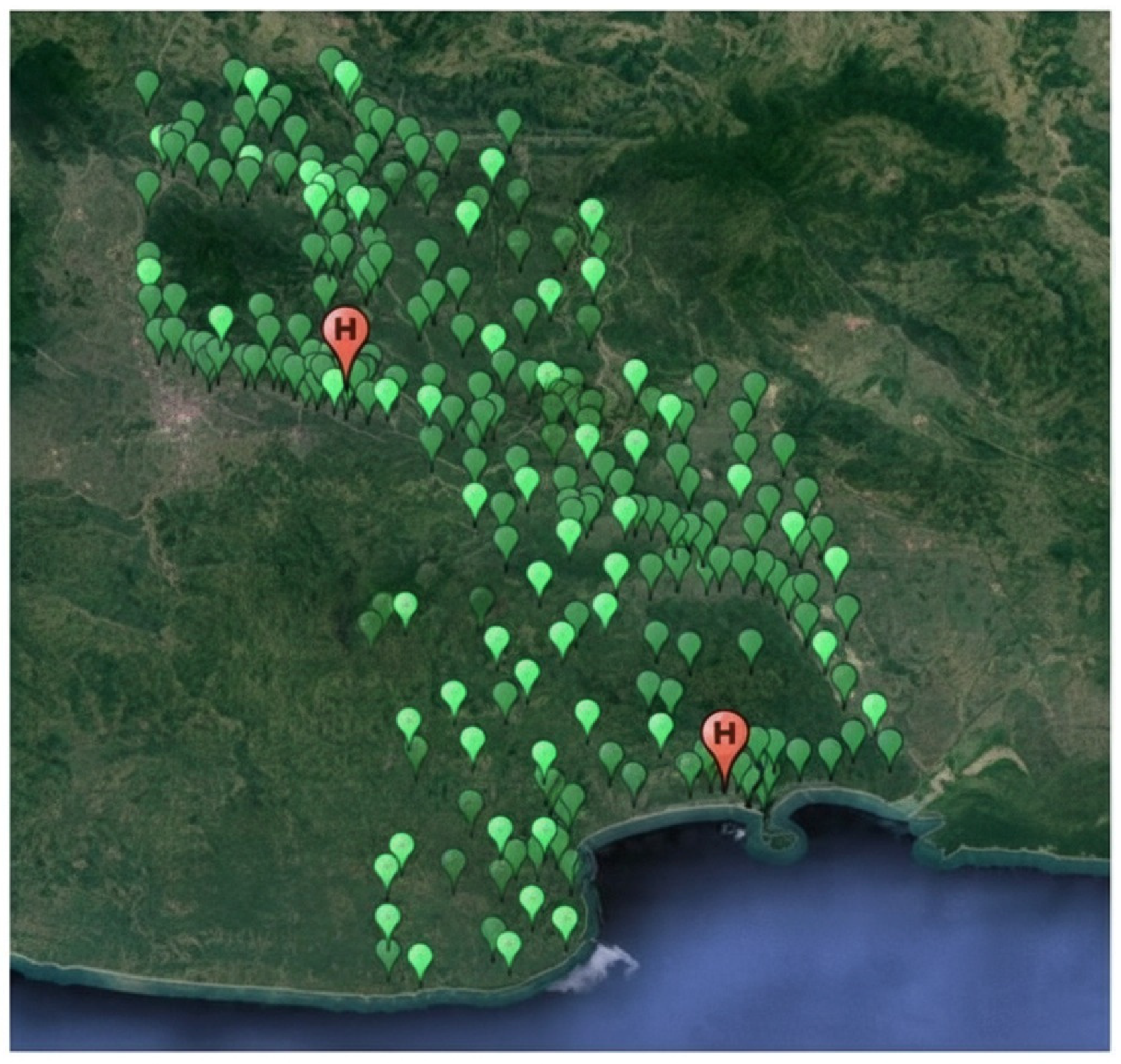
Indonesia provides a pertinent case for addressing these challenges, given its vast archipelagic geography and rapidly growing digital economy. The Ciamis Cluster of West Java, comprising 282 telecommunication towers operated from two central homebases (Ciamis and Pangandaran), exemplifies the logistical and sustainability challenges of dispersed infrastructure. As illustrated in
Figure 1, towers are geographically scattered across rural and semi-urban areas, often requiring long travel distances for maintenance engineers. Without systematic geospatial frameworks, prolonged travel times, excessive fuel usage, and imbalanced workloads become unavoidable. These conditions highlight the urgent need for methods that integrate geospatial analysis with SSCM principles to ensure efficient, sustainable, and equitable deployment strategies [
9].
To address this problem, this study develops and applies a GIS-based optimization framework to evaluate and improve workforce deployment strategies for telecommunication tower maintenance. Using accessible tools such as Google Earth Pro (version 7.3) and Microsoft Excel (version 2601), tower and homebase coordinates were mapped and analyzed using Haversine-based geodesic distance calculations, complemented by a comparison with Euclidean approximation, to assess alternative allocation strategies. In addition, a clustering-based approach is employed to identify potential sub-homebase configurations that reduce travel distance and improve spatial compactness. This practical framework is designed for scalability and replicability, particularly for operators in resource-constrained environments who may not have access to advanced proprietary systems. In doing so, the research demonstrates how low-cost, geospatially enabled methods can bridge the gap between SSCM theory and telecom operational practice [
4,
13].
The contributions of this study are threefold. The primary contribution of this study lies not in the development of a novel optimization algorithm, but in the operational integration of geospatial deployment analysis with sustainable supply chain management principles within a real-world infrastructure maintenance context [
1,
2]. By emphasizing practical implementability using widely accessible tools, the framework demonstrates how spatial decision-support methods can be translated into actionable sustainability improvements in resource-constrained service environments. Second, it empirically demonstrates how geospatial restructuring can reduce total travel distance and associated carbon emissions, thereby strengthening the environmental dimension of sustainable infrastructure management in a developing-country context. Third, it provides actionable insights for telecom providers and policymakers seeking to enhance the sustainability of digital infrastructure operations through data-driven and spatially informed decision-making. The remainder of this paper is structured as follows:
Section 2 reviews the relevant literature on SSCM, GIS applications, and workforce optimization.
Section 3 presents the methodology and data used in the study.
Section 4 discusses the results, highlighting both operational improvements and sustainability impacts. Finally,
Section 5 concludes with key implications, limitations, and directions for future research.
2. Literature Review
Sustainable supply chain management (SSCM) has emerged as a central paradigm in operations research, integrating economic, social, and environmental objectives into decision-making. While SSCM is well developed in manufacturing, energy, and transportation, its application to digital infrastructure operations remains scarce. Recent studies emphasize that sustainable supply chains are not only enablers of resilience but also essential for minimizing environmental impacts in geographically dispersed sectors [
1,
14,
15]. Visibility-enhancing technologies such as IoT-enabled monitoring and supply chain control towers have further advanced this integration, allowed real-time visibility of operational and sustainability performance indicators, reinforcing the importance of embedding sustainability principles in infrastructure management [
16,
17].
A critical dimension of SSCM in infrastructure operations concerns the optimization of resource deployment, particularly workforce allocation. Traditional workforce management approaches often prioritize cost efficiency and service responsiveness while overlooking sustainability outcomes, resulting in inefficiencies, excessive operating costs, and unnecessary environmental burdens [
18,
19]. In mobility-intensive service systems, workforce travel represents a major contributor to fuel consumption and emissions, yet this aspect is rarely incorporated explicitly into sustainability-oriented decision models. By integrating spatial analysis into workforce deployment planning, organizations can simultaneously improve operational efficiency and environmental performance, achieving measurable reductions in greenhouse gas (GHG) emissions and energy use [
20]. This intersection of operations research, spatial analytics, and sustainability science offers significant opportunities for advancing both theoretical and practical approaches to managing digital infrastructure services.
Geographic Information Systems (GIS) provide a powerful foundation for embedding spatial intelligence into operational decision-making. Originally developed for mapping and land-use planning, GIS applications have evolved to support advanced decision support in logistics, resource allocation, and sustainability-oriented urban and regional planning [
3,
4,
9,
13]. In solid waste collection, GIS-enabled routing has been shown to significantly reduce travel distances, fuel consumption, and emissions [
5,
6]. Similarly, in agriculture, GIS-based precision planning supports the efficient allocation of land and water resources, contributing to environmental conservation and productivity gains [
4,
21]. These empirical successes demonstrate the capacity of GIS-driven approaches to align operational efficiency with sustainability objectives across multiple sectors [
22,
23]. More recently, the adoption of GIS-enabled digital twins in logistics and infrastructure networks highlights the growing role of spatial analytics in real-time operational optimization and sustainability monitoring [
24].
In the telecommunications sector, GIS has been predominantly applied to network design, site selection, and tower placement, demonstrating its effectiveness in improving coverage, capacity, and service reliability [
11]. However, workforce allocation and routine tower maintenance operations remain comparatively underexplored research areas. Only a limited number of studies have empirically examined how GIS-based methods can support field engineer deployment and daily maintenance planning, despite the inherently spatial nature of telecommunication infrastructure [
25]. In developing regions, where towers are widely dispersed across rural and semi-urban landscapes, the absence of systematic GIS-based workforce optimization exacerbates sustainability challenges, leading to longer travel distances, uneven workloads, and increased operational emissions.
Optimization methodologies represent another relevant stream of literature informing this study. Multi-objective optimization approaches have been widely explored in industrial processes and logistics systems, particularly for balancing cost, service quality, and environmental performance [
7,
8]. Their application to workforce management, however, remains uneven. Clustering techniques are frequently employed to balance workloads and define service territories [
12], while routing heuristics primarily focus on minimizing travel distance, cost, or service time [
5,
26]. A recurring methodological debate within this domain concerns the selection of distance metrics. Euclidean distance approximation is often favored due to its computational simplicity, particularly in semi-urban and rural contexts [
11]. Conversely, critics argue that Euclidean measures underestimate actual travel effort and energy consumption, advocating instead for geodesic or road-network distance metrics to achieve greater realism in spatial modeling [
12]. This methodological tension reflects the “no free lunch theorem” of optimization, which emphasizes that no single optimization approach is universally optimal across all problem settings [
2,
27]. Accordingly, effective workforce deployment frameworks must carefully balance methodological accuracy, data availability, and operational feasibility.
Field Service Management (FSM) systems provide a complementary digital perspective on workforce optimization by enabling coordination of geographically dispersed service personnel through analytics, mobile connectivity, and decision-support tools [
17]. When integrated with GIS, FSM systems have demonstrated substantial benefits in sectors such as utilities, healthcare, and waste management, including improved scheduling efficiency, enhanced service quality, and reduced downtime [
28,
29]. Importantly, FSM systems explicitly aligned with sustainability objectives have reported measurable reductions in travel distances, operational costs, and associated emissions [
29], underscoring their relevance for infrastructure service sectors characterized by high mobility demands.
The sustainability impacts of GIS-enabled workforce optimization extend beyond environmental benefits alone. Social sustainability is enhanced through reduced worker fatigue, improved occupational safety, and more equitable workload distribution [
16]. At the same time, economic sustainability is strengthened through lower fuel consumption, reduced maintenance costs, and improved asset utilization [
30]. Empirical studies across logistics, public services, and environmental management consistently demonstrate that GIS based optimization contributes to all three pillars of sustainability economic viability, environmental stewardship, and social equity [
14,
20]. Nevertheless, systematic application of these integrated approaches within telecommunication maintenance operations remains limited, particularly in developing-country contexts.
In summary, existing literature provides strong evidence that GIS and optimization frameworks can deliver substantial sustainability benefits across diverse operational domains. However, three critical gaps remain. First, SSCM principles have been only marginally applied to telecommunication field maintenance operations. Second, there is a lack of empirical, data-driven validation of GIS-based workforce deployment strategies in developing countries. Third, many existing approaches rely on proprietary software platforms, limiting scalability and accessibility in resource-constrained environments. This study addresses these gaps by proposing and empirically applying a replicable, low-cost, GIS-based optimization framework for telecommunication tower maintenance in Indonesia, thereby contributing to both SSCM scholarship and the practice of sustainable digital infrastructure management.
3. Materials and Methods
This study was conducted to design and evaluate a geospatial optimization framework for improving the deployment of field engineers responsible for telecommunication tower maintenance. The methodological approach was developed to balance analytical rigor with practical applicability, ensuring that the proposed framework can be readily adopted by infrastructure operators in resource-constrained environments. To this end, the study relies exclusively on publicly available software tools and standard spatial data formats, allowing full methodological transparency and reproducibility.
The overall research design follows a structured and sequential workflow. First, spatial data describing the locations of telecommunication towers and operational homebases were collected and prepared for analysis. Second, distance metrics were defined and applied to quantify spatial relationships between towers and service bases. Third, operational assumptions regarding workforce capacity were established based on observed maintenance practices. Fourth, alternative deployment scenarios were developed and compared to assess the impact of spatial reconfiguration on travel distance and workload distribution. Finally, the scenarios were evaluated using sustainability-oriented performance metrics encompassing operational, environmental, and social dimensions.
By integrating geospatial analysis with workforce deployment modeling, the methodology explicitly links spatial efficiency to sustainability outcomes, rather than treating distance reduction as a purely technical objective. This integrated perspective aligns with the scope of Environments, where environmental performance, operational decision-making, and applied sustainability are examined in combination. The following subsections describe the study area and data sources, analytical tools and distance metrics, operational assumptions, scenario design, and evaluation criteria in detail.
3.1. Data Sources and Preparation
The primary dataset consisted of telecommunication tower coordinates provided in Google Earth Keyhole Markup Language (KML) format. The dataset was filtered to isolate towers located within the Ciamis Cluster in West Java, Indonesia. Additional spatial data describing the geographic locations of the two operational homebases, Ciamis and Pangandaran, were included to support baseline allocation analysis.
All spatial coordinates were converted into decimal-degree format to ensure consistency in distance computation and spatial comparison. The KML files were subsequently converted into Microsoft Excel (.xlsx) format to facilitate numerical analysis, including distance calculation, tower allocation, and scenario comparison.
All data used in this study were obtained through an industry internship program within the Operation and Maintenance (O&M) Division of a major national telecommunication infrastructure provider. Due to contractual confidentiality agreements, the raw datasets cannot be made publicly available. However, the methodological framework, analytical procedures, and calculation logic are fully reproducible using any dataset consisting of tower and homebase coordinates. To support methodological transparency, synthetic or anonymized datasets and calculation templates will be made available by the corresponding author upon reasonable request.
3.2. Distance Metrics and Spatial Analysis
Two widely accessible and non-proprietary tools were employed in this study: Google Earth Pro (version 7.3) and Microsoft Excel (version 2601). Google Earth Pro (version 7.3) was used to visualize the spatial distribution of telecommunication towers, generate coverage radii around existing homebases, and support the preliminary identification of potential sub-homebase locations. Microsoft Excel (version 2601) was used for numerical processing, including distance computation, tower allocation, and scenario-based comparison of deployment strategies. The use of these tools reflects the objective of developing a low cost, transparent, and replicable methodology that can be readily adopted in resource constrained operational environments.
To quantify spatial relationships between towers and service bases, distance metrics were defined and applied. As a benchmark, Euclidean distance was calculated due to its computational simplicity and widespread use in spatial optimization studies, particularly in semi-urban and rural contexts where detailed road-network data are often unavailable or unreliable. The Euclidean distance (
d) between a tower and a homebase was computed using Equation (1):
where
and
denote the longitude coordinates of two locations, and
and
denote the latitude coordinates, all expressed in decimal degrees. To convert angular coordinate differences into linear distance, geographic coordinates were approximated using an average conversion factor of 111.319 km per degree of latitude. This planar approximation assumes locally uniform spatial scaling and does not account for Earth curvature or longitudinal convergence. Accordingly, Euclidean distance is used in this study only as a simplified comparative indicator of spatial separation rather than as a precise representation of geographic travel distance.
For large-scale geographic separation, however, planar approximations may introduce distortion due to Earth curvature. While Euclidean distance provides an efficient approximation of spatial separation, it does not account for the curvature of the Earth and may underestimate true geographic distance, particularly when sites are widely dispersed. To improve spatial realism, geodesic distances were therefore computed using the Haversine formula, which calculates the great-circle distance between two points on the surface of a sphere. The Haversine distance
was calculated using Equation (2):
where
,
are the latitudes of two locations in radians,
,
are the longitudes in radians,
,
,
R is the mean radius of the earth, assumed to be 6371 km.
In this study, Haversine distance was adopted as the primary metric for evaluating travel distance, estimating fuel consumption, and calculating associated carbon emissions, as it provides a more accurate representation of geographic separation between towers and service bases. Euclidean distance was retained as a comparative reference to assess the sensitivity of allocation outcomes to distance-measurement assumptions and to reflect common practice in prior spatial optimization studies.
The combined use of Euclidean and Haversine distance metrics enables methodological robustness by balancing computational efficiency with spatial accuracy. This dual-metric approach is particularly suitable for semi-urban and rural contexts, where road-network data are often incomplete, yet sustainability assessments require realistic distance estimation to support defensible environmental impact evaluation.
While road-network distance provides a more realistic representation of travel effort, detailed and consistently structured network data were not available for all service areas in the study region. For this reason, geodesic (Haversine) distance was used as a practical and widely accepted approximation of spatial separation in semi-urban and rural planning contexts. Previous spatial planning studies have shown that geodesic distance typically underestimates actual travel distance by approximately 10–30%, depending on network density and terrain characteristics. This level of approximation is considered acceptable for strategic allocation and clustering analysis, although it may not capture route-level variability.
3.3. Workforce Assumptions and Capacity Estimation
Workforce requirements in this study were estimated based on operational parameters obtained through direct consultation with the Operation and Maintenance (O&M) Division of the telecommunication infrastructure provider. These parameters reflect routine preventive maintenance practices and represent realistic operational conditions in semi-urban and rural service environments.
Each field engineer was assumed to serve an average of two telecommunication towers per working day. A single maintenance visit was estimated to require approximately one hour, including inspection, minor corrective actions, and administrative reporting. Preventive maintenance activities are scheduled within a standard cycle of 25 working days. Under these assumptions, one engineer can service up to 50 towers per maintenance cycle. This productivity assumption represents an operational average and does not account for variability in maintenance complexity, travel accessibility, weather conditions, or site-specific technical requirements.
Given a total of 282 towers in the Ciamis Cluster, the required workforce size was calculated as 282 divided by 50, yielding an estimated requirement of 5.64 engineers. To ensure full coverage and operational robustness, this value was rounded up to six engineers. This rounding approach reflects common industry practice, where workforce planning prioritizes service reliability and risk mitigation over strict numerical equivalence.
For baseline allocation, a coverage radius of 30 km was defined around each existing homebase to represent the maximum feasible daily travel distance for field engineers. Towers located within overlapping coverage areas were assigned to the nearest homebase based on minimum geodesic distance. This allocation resulted in 172 towers assigned to the Ciamis homebase and 110 towers assigned to the Pangandaran homebase, with three engineers allocated to each homebase.
The operational assumptions applied in the workforce estimation and deployment analysis are summarized in
Table 1. These assumptions provide a transparent basis for scenario comparison and ensure that differences in performance between deployment strategies are attributable to spatial configuration rather than changes in workforce capacity.
3.4. Scenario Design and Sub-Homebase Configuration
To evaluate the impact of spatial reconfiguration on workforce deployment and sustainability performance, two deployment scenarios were developed and compared. Both scenarios were designed using the same workforce capacity and operational assumptions described in
Section 3.3, ensuring that observed differences in performance are attributable solely to spatial configuration rather than changes in resource availability.
Baseline Scenario (Two-Homebase Model): In the baseline configuration, engineers were assigned to telecommunication towers based exclusively on proximity to the two existing operational homebases located in Ciamis and Pangandaran. Tower allocation followed a minimum-distance rule using geodesic distance, with a coverage radius of 30 km applied to represent feasible daily travel limits. Towers located within overlapping coverage zones were assigned to the nearest homebase. This scenario reflects the current operational practice and serves as a reference point for evaluating spatial inefficiencies in the existing deployment strategy.
Improved Scenario (Sub-Homebase Model): In the improved configuration, four sub-homebases were introduced, two within the Ciamis region and two within the Pangandaran region to reduce travel distances for engineers assigned to geographically dispersed towers. The locations of sub-homebases were determined through spatial clustering of tower coordinates, with the objective of improving territorial compactness and minimizing long-distance travel.
Spatial clustering was performed using the k-means algorithm to partition tower locations into geographically compact groups based on coordinate proximity. The number of clusters was determined based on operational feasibility and the planned decentralized deployment structure, which maintains workforce size while reducing service territory dispersion. The clustering objective was therefore aligned with practical deployment constraints rather than purely statistical cluster optimization criteria. The clustering objective was to minimize within-cluster spatial variance, thereby forming service territories that are internally cohesive and externally separated. The number of clusters was determined in accordance with the planned decentralized deployment structure and regional tower density. Cluster centroids were interpreted as candidate locations for sub-homebases, representing spatially optimal reference points for service coverage. This clustering-based approach enables systematic identification of decentralized operational nodes that reduce service territory dispersion and long-distance travel requirements. Towers were subsequently reallocated to the nearest sub-homebase, and each engineer was anchored to a sub-homebase located closer to their assigned service area.
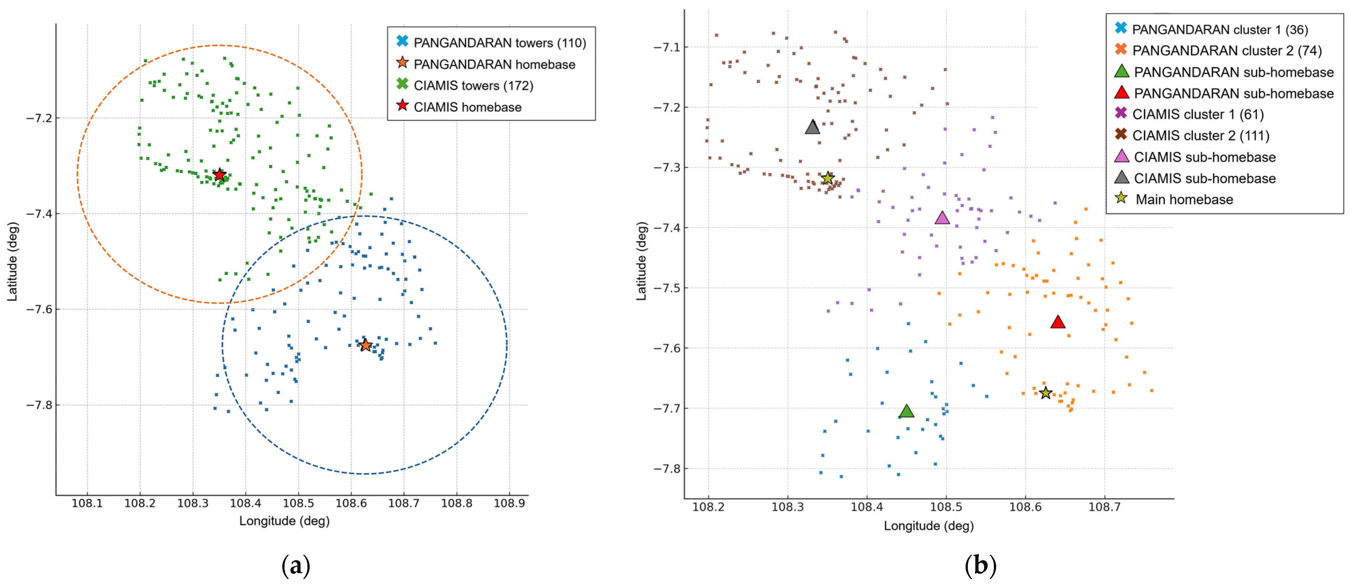
The spatial allocation outcomes resulting from clustering-based sub-homebase identification are illustrated in
Figure 2. In the baseline scenario (
Figure 2a), a substantial number of towers are located at the periphery of the coverage areas, requiring engineers to travel long distances from centralized homebases. These extended service areas contribute to higher fuel consumption, increased travel time, and reduced availability for maintenance activities. In contrast, the sub-homebase configuration (
Figure 2b) produces more compact service territories by redistributing towers across additional service points. This spatial restructuring reduces long-distance assignments, improves workload balance among engineers, and enhances time allocation for on-site maintenance tasks.
From a sustainability perspective, the introduction of sub-homebases is expected to yield multiple benefits. Shorter travel distances directly contribute to reduced fuel consumption and associated carbon emissions, supporting environmental sustainability objectives. At the same time, more localized service areas promote social sustainability by reducing travel-related fatigue and enabling more equitable workload distribution among field engineers. The comparison between the two scenarios thus provides a structured basis for assessing how geospatial optimization can align operational efficiency with environmental and social performance in telecommunication tower maintenance operations.
3.5. Sustainability Evaluation Metrics
To assess the performance of alternative workforce deployment strategies, the baseline and improved scenarios were evaluated using a set of sustainability-oriented metrics encompassing operational, environmental, and social dimensions. The use of multiple evaluation dimensions ensures that improvements in spatial efficiency are examined not only from an operational perspective but also in terms of broader sustainability outcomes.
Operational efficiency was evaluated based on total travel distance and workload distribution among field engineers. Travel distance serves as a direct indicator of spatial efficiency and reflects the effectiveness of tower allocation under each deployment scenario. Workload balance was assessed by examining the distribution of assigned towers across engineers, with more equitable allocations indicating improved operational robustness and reduced risk of service bottlenecks.
Environmental sustainability was approximated through reductions in fuel consumption and associated carbon dioxide (CO2) emissions resulting from shorter travel distances. Fuel consumption was estimated using distance-based calculations combined with representative vehicle fuel efficiency, while CO2 emissions were derived using standard emission factors. This approach enables a transparent and reproducible estimation of environmental impacts without requiring detailed vehicle telemetry or proprietary fuel-use data, which are often unavailable in operational settings.
Social sustainability was assessed qualitatively through indicators related to workforce well-being, including reduced exposure to long travel distances and more equitable distribution of service territories. Shorter and more localized travel patterns are expected to lower travel-related fatigue, enhance occupational safety, and improve overall job satisfaction among field engineers. Although these social outcomes are not quantified directly, they represent important considerations in sustainable field service management.
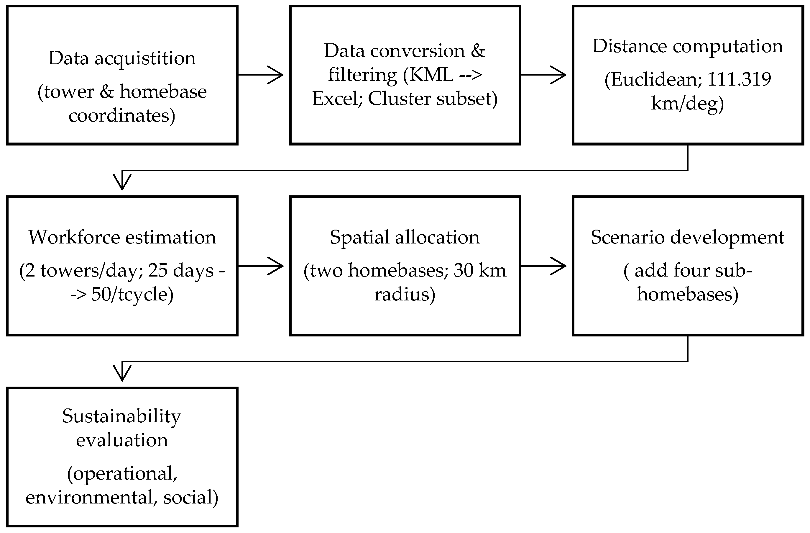
The overall methodological framework applied in this study is illustrated in
Figure 3, which summarizes the sequential stages of analysis from data acquisition to sustainability evaluation. Beyond serving as a procedural guide, the framework emphasizes the integration of spatial efficiency with environmental and social sustainability objectives, clarifying that distance computation and workforce estimation are intermediate inputs to broader performance outcomes. By structuring the analysis from raw spatial data to multi-dimensional sustainability assessment, the framework ensures transparency, reproducibility, and scalability, while accommodating methodological refinements such as alternative distance metrics or scenario-based spatial reconfiguration.
3.6. Data Availability and Ethical Considerations
All analyses in this study were conducted using anonymized spatial data obtained through an industry internship program within the Operation and Maintenance (O&M) Division of a major national telecommunication infrastructure provider. Due to contractual confidentiality agreements, the raw datasets containing exact tower and homebase coordinates cannot be made publicly available.
Nevertheless, the methodological framework, analytical procedures, and calculation logic presented in this study are fully reproducible using any dataset consisting of telecommunication tower and homebase coordinates. To support transparency and replicability, synthetic or anonymized datasets and calculation templates will be made available by the corresponding author upon reasonable request.
This study did not involve human participants, personal data, or experiments on animals. Therefore, ethical approval was not required.
3.7. Disclosure of Generative AI Use
In accordance with MDPI transparency guidelines, generative artificial intelligence tools (ChatGPT, OpenAI GPT-5) were used solely to assist in language refinement, structural editing, and improvement of academic clarity during manuscript preparation. No generative AI tools were used to generate, modify, analyze, or interpret data, figures, or results presented in this study. The authors reviewed and edited all outputs and take full responsibility for the content of this publication.
4. Results and Discussion
The results of the geospatial analysis provide quantitative evidence of the inefficiencies inherent in the existing two-homebase deployment strategy and the improvements achieved through the introduction of sub-homebases. Consistent with the sustainability evaluation framework described in
Section 3.5, the findings are presented across four dimensions: (i) workforce requirement estimation, (ii) workload allocation under the baseline scenario, (iii) spatial efficiency and environmental impacts of the sub-homebase scenario, and (iv) critical interpretation of sustainability trade-offs.
Importantly, all travel distance calculations reported in this section are based on Haversine (geodesic) distance, as described in
Section 3.2, while Euclidean distance was used solely for comparative benchmarking and sensitivity reference.
4.1. Estimation of Workforce Requirement
Based on the operational assumptions summarized in
Table 1, the Ciamis Cluster requires a minimum of six field engineers to maintain 282 telecommunication towers within a 25-working-day preventive maintenance cycle. With each engineer capable of servicing approximately 50 towers per cycle, the calculated requirement of 5.64 engineers was rounded up to six to ensure complete coverage and operational robustness.
This workforce size was held constant across all deployment scenarios to isolate the effects of spatial configuration on operational efficiency and sustainability outcomes. Consequently, differences observed in workload balance, travel distance, and environmental impact can be attributed directly to spatial allocation strategies rather than changes in personnel capacity.
4.2. Baseline Scenario: Two-Homebase Allocation
Under the existing two-homebase configuration, towers were assigned to the nearest operational center (Ciamis or Pangandaran) within a 30 km coverage radius. This allocation resulted in 172 towers assigned to the Ciamis homebase and 110 towers to the Pangandaran homebase, with three engineers allocated to each location. The resulting workload distribution is presented in
Table 2.
The results reveal a pronounced imbalance in workload distribution. Although both homebases were assigned to an equal number of engineers, personnel based in Ciamis were responsible for more than 57 towers on average, compared with fewer than 37 towers per engineer in Pangandaran. This disparity reflects the uneven spatial distribution of telecommunication infrastructure and highlights the limitations of centralized allocation strategies that rely solely on proximity to major homebases.
From an operational standpoint, this imbalance may lead to overburdened personnel, reduced maintenance quality, and inefficient utilization of available workforce capacity. From a sustainability perspective, longer travel distances and uneven workloads increase the likelihood of travel-related fatigue, elevated fuel consumption, and reduced system resilience.
4.3. Improved Scenario: Sub-Homebase Augmentation and Environmental Impact
To address the inefficiencies observed in the baseline configuration, an improved deployment strategy was developed by introducing four sub-homebases, two in the Ciamis region and two in the Pangandaran region based on spatial clustering of tower locations. The total workforce size remained unchanged at six engineers to ensure direct comparability with the baseline scenario.
Under the sub-homebase configuration, each engineer was responsible for an average of approximately 47 towers, comparable to the baseline average. However, the primary improvement lies in the spatial compactness of assignments rather than in workload counts alone.
Table 3 summarizes the comparison between the two scenarios.
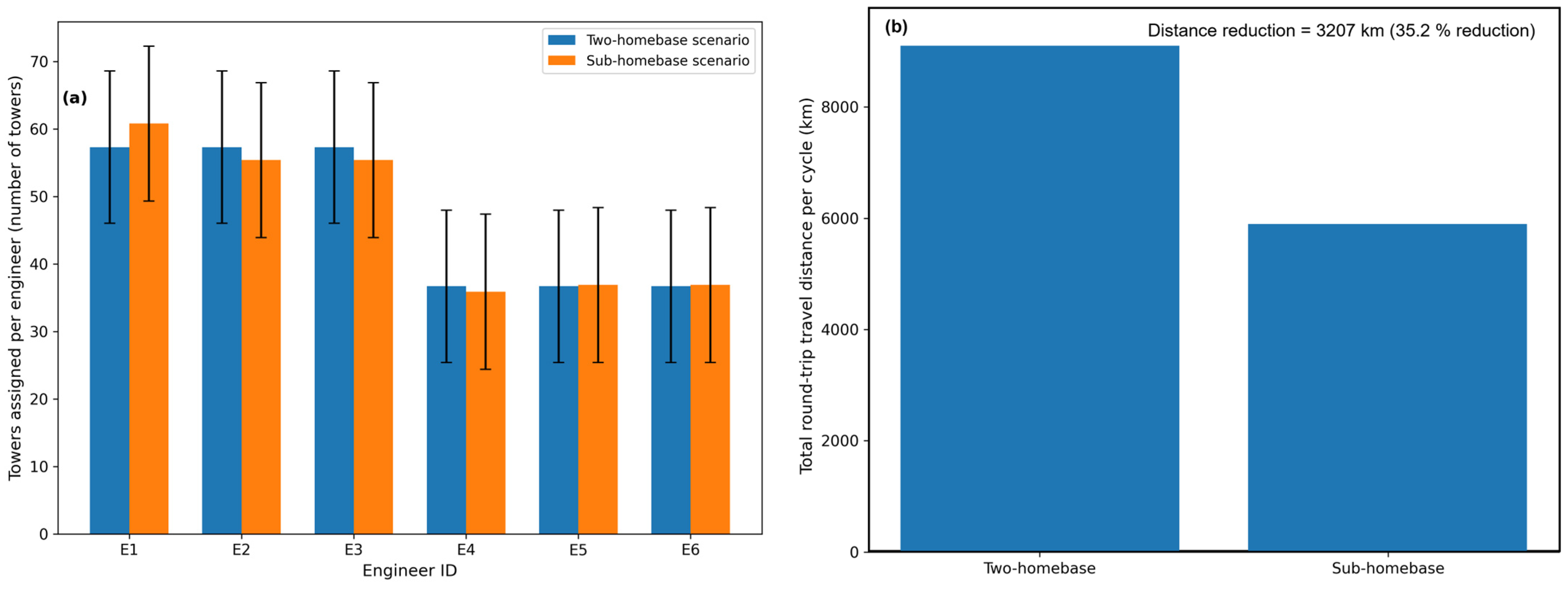
Although workload variance increases slightly in the sub-homebase scenario, this trade-off is offset by substantial reductions in travel distance. Based on Haversine distance calculations, the total round-trip travel distance per maintenance cycle decreased from approximately 9120 km in the two-homebase scenario to 5913 km in the sub-homebase scenario. This represents a 35.2% reduction, equivalent to a distance saving of 3207 km per cycle.
To estimate environmental impacts, fuel consumption was approximated assuming the use of typical 1.3–1.5 L gasoline service vehicles with an effective fuel efficiency of approximately 12–13 km/L under mixed semi-urban and rural operating conditions, consistent with representative passenger vehicle performance reported in transportation energy assessments [
31]. Under this assumption, the observed reduction in travel distance corresponds to a fuel saving of approximately 260–270 L per maintenance cycle. Using a standard emission factor of 2.31 kg CO
2 per liter of gasoline, as reported in international greenhouse gas inventory guidelines (e.g., IPCC emission factors) [
32,
33], this translates to an estimated reduction of approximately 590 kg of CO
2 emissions per cycle. This estimate reflects a reduction in operational travel demand associated with the restructured deployment configuration rather than a system-wide or life-cycle reduction in emissions. The value represents an approximate operational indicator derived from distance-based fuel consumption modeling and should therefore be interpreted as a measure of relative efficiency improvement between deployment scenarios rather than an absolute environmental impact assessment. Nevertheless, the magnitude of reduction illustrates the potential environmental implications of spatially optimized deployment strategies in mobility-intensive service systems. In relative terms, this reduction represents a proportional decrease in travel-related emissions corresponding directly to the 35.2% reduction in total operational travel distance, providing a system-level indicator of improved deployment efficiency within the defined maintenance cycle.
Beyond environmental benefits, shorter travel distances are expected to contribute to improved social sustainability outcomes by reducing travel-related fatigue and enhancing occupational safety. The redistribution of workloads across engineers is depicted in
Figure 4a, which illustrates differences in workload allocation and variability between scenarios. Complementarily,
Figure 4b quantifies the reduction in total round-trip travel distance per maintenance cycle, providing a direct measure of the spatial efficiency improvements underlying the observed sustainability gains.
From a practical implementation perspective, the proposed framework can be operationalized through a structured sequence of steps. First, infrastructure providers compile geographic coordinates of service assets and existing operational bases. Second, spatial analysis is conducted to evaluate current deployment patterns and identify travel inefficiencies. Third, clustering techniques are applied to determine spatially compact service territories and candidate locations for sub-homebases. Fourth, workforce assignments are restructured based on the revised spatial configuration while maintaining operational constraints such as service capacity and working hours. Finally, deployment performance is monitored using distance-based workload indicators to evaluate operational efficiency and sustainability outcomes. This structured workflow enables infrastructure providers to translate geospatial analysis into actionable deployment strategies without requiring advanced proprietary optimization systems.
In practice, the implementation of sub-homebase configurations requires organizational and operational adjustments beyond spatial analysis alone. Infrastructure providers must evaluate logistical feasibility, including the availability of suitable facilities, coordination mechanisms, and operational supervision across decentralized service locations. The establishment of additional sub-homebases may involve incremental administrative and resource requirements, such as equipment relocation, scheduling adjustments, and personnel coordination.
Therefore, while the proposed framework demonstrates structural spatial efficiency improvements, its operational adoption depends on context-specific managerial considerations, including cost–benefit trade-offs, organizational capacity, and regional accessibility conditions. These practical factors should be evaluated alongside spatial efficiency indicators when translating geospatial optimization results into real-world deployment strategies.
4.4. Critical Interpretation and Sustainability Trade-Offs
The comparative results highlight that workforce deployment efficiency in telecommunication maintenance operations cannot be adequately assessed using workload counts alone. While the baseline two-homebase scenario exhibits a clear numerical imbalance in tower assignments, this imbalance represents only one dimension of operational performance. The analysis demonstrates that spatial structure and travel patterns play an equally critical role in determining overall efficiency and sustainability outcomes.
In the baseline configuration, the concentration of towers around a limited number of centralized homebases results in elongated service territories, particularly in geographically peripheral areas. Although workload imbalance is immediately visible in the form of unequal tower counts per engineer, the more significant inefficiency lies in excessive travel distances. Long-distance travel not only increases fuel consumption and emissions but also reduces the proportion of working hours available for productive maintenance activities. From a systems perspective, this configuration prioritizes administrative simplicity over spatial efficiency, leading to suboptimal sustainability performance.
By contrast, the sub-homebase scenario introduces a more decentralized spatial structure that prioritizes territorial compactness. Although the redistribution of towers results in a modest increase in workload variance, the spatial proximity of assigned towers substantially improves travel efficiency. This finding reveals an important trade-off: a perfectly balanced numerical workload does not necessarily correspond to optimal operational or environmental performance. This reflects a fundamental spatial allocation trade-off, where minimizing travel distance and improving territorial compactness may require accepting moderate deviations from numerical workload equality. In mobility-intensive service systems, spatial compactness can outweigh minor inequities in workload distribution, particularly when those inequities remain within acceptable operational limits from a system-level efficiency perspective.
From a spatial systems perspective, clustering improves operational performance by restructuring service territories into more geographically cohesive units. When service locations are spatially dispersed across large coverage areas, engineers must frequently traverse long inter-site distances, increasing non-productive travel time and resource consumption. Clustering reduces this dispersion by grouping proximate service locations into compact territorial units, thereby shortening average travel paths and reducing deadheading movement between distant sites. This territorial consolidation enhances spatial accessibility, stabilizes service coverage boundaries, and improves the efficiency of localized workforce deployment. Consequently, clustering-driven decentralization improves operational performance not only by redistributing workload, but by fundamentally altering the geometric structure of service territories.
From an environmental sustainability perspective, the observed reduction in total travel distance directly translates into lower fuel consumption and reduced carbon emissions. Importantly, these environmental gains are achieved without increasing workforce size or relying on advanced proprietary optimization software. This underscores the effectiveness of relatively simple geospatial restructuring in delivering meaningful environmental benefits, reinforcing the argument that sustainability improvements in infrastructure operations do not always require capital-intensive technological interventions.
However, these environmental improvements should be interpreted in the context of the spatial modeling assumptions applied in this study. Travel distances were estimated using geodesic (Haversine) separation rather than detailed road-network routing, meaning that the reported reductions represent improvements in spatial efficiency rather than precise operational travel savings. Actual travel distances may vary depending on network connectivity, terrain conditions, and routing constraints. Consequently, the estimated carbon emission reductions should be understood as operational approximations derived from distance-based modeling rather than full real-world emission measurements.
Social sustainability considerations further strengthen the case for the sub-homebase configuration. Shorter and more localized travel routes are expected to reduce travel-related fatigue, improve occupational safety, and enhance overall job satisfaction among field engineers. These potential benefits are conceptual expectations derived from mobility reduction rather than directly observed workforce responses. Although these social outcomes are not quantified directly in this study, they represent critical qualitative dimensions of sustainable workforce management that complement the observed environmental and operational benefits.
Accordingly, the social sustainability implications reported here are inferred from operational proxy indicators, particularly travel distance and territorial compactness, which are widely associated with workload strain and mobility exposure in field service systems. While these indicators provide a reasonable basis for interpreting potential workforce impacts, direct measurement through survey-based or physiological assessment would be required to confirm the magnitude of these effects. Accordingly, the social sustainability outcomes discussed in this study should be interpreted as theoretically informed expectations rather than empirically validated measurements.
From a broader sustainable supply chain management perspective, the findings illustrate the interdependence of spatial decision-making, workforce well-being, and environmental performance. The results suggest that sustainable field service operations require a balanced evaluation of three interrelated objectives: equitable workload distribution, minimization of travel-related inefficiencies, and reduction in environmental impacts. Optimizing any single dimension in isolation is unlikely to produce robust sustainability outcomes.
These findings also highlight an important conceptual distinction between spatial efficiency and operational routing efficiency. While spatial clustering reduces geometric separation between service locations, actual travel performance depends on network structure, accessibility, and scheduling dynamics. Therefore, the sustainability gains observed in this study should be interpreted as structural improvements in deployment configuration rather than route-level optimization outcomes.
Finally, the analysis highlights the importance of context-sensitive optimization. The effectiveness of the sub-homebase strategy is closely tied to the semi-urban and rural characteristics of the study area, where dispersed assets and limited road-network data constrain more complex routing approaches. In such contexts, geospatial clustering and decentralized service bases offer a pragmatic and scalable alternative to traditional centralized deployment models. These insights extend beyond the telecommunications sector and are applicable to other infrastructure service systems characterized by dispersed assets and mobility-intensive workforce requirements.
5. Conclusions
This study developed and applied a geospatial optimization framework to improve the deployment of field engineers responsible for telecommunication tower maintenance in a semi-urban and rural context in West Java, Indonesia. By integrating spatial analysis with operational and sustainability considerations, the research demonstrates that workforce deployment efficiency cannot be evaluated solely on the basis of numerical workload balance, but must also account for spatial compactness, travel distance, and associated environmental and social impacts.
The results confirm that the existing two-homebase deployment strategy leads to substantial spatial inefficiencies, manifested in excessive travel distances and pronounced workload imbalance across engineers. The introduction of sub-homebases, identified through geospatial clustering of tower locations, significantly reduced total travel distance by approximately 35.2% per maintenance cycle. This reduction reflects an improvement in spatial deployment efficiency and is estimated to correspond to operational reductions in travel demand. The reduction translated into environmental benefits, including lower fuel consumption and an estimated reduction of around 590 kg of CO2 emissions per cycle, based on distance-derived emission modeling rather than direct measurement of vehicle activity, without increasing workforce size or relying on proprietary optimization software.
From an operational perspective, the findings highlight an important trade-off between numerical workload balance and spatial efficiency. While the sub-homebase configuration introduced a modest increase in workload variance, this effect was outweighed by substantial gains in travel efficiency and time utilization. These results emphasize that, in mobility-intensive service systems, spatial structure and territorial compactness are critical determinants of sustainable performance. From a social sustainability standpoint, shorter and more localized travel patterns are expected to reduce travel-related fatigue and enhance occupational safety, thereby supporting more equitable and resilient workforce management. However, these social sustainability implications are inferred from operational proxy indicators, particularly travel distance and spatial compactness, and were not directly measured through behavioral or physiological assessment.
The primary contribution of this study lies in demonstrating how low-cost, geospatially enabled methods can bridge the gap between sustainable supply chain management theory and the operational realities of digital infrastructure maintenance. By relying on publicly available tools and transparent assumptions, the proposed framework offers a replicable and scalable solution for infrastructure providers operating in resource-constrained environments. Beyond the telecommunications sector, the approach is transferable to other infrastructure service systems characterized by dispersed assets and high workforce mobility.
Despite these contributions, several limitations should be acknowledged. First, travel distances were estimated using geodesic (Haversine) distance rather than detailed road-network data, which may lead to under- or over-estimation of actual travel effort in certain locations. Accordingly, the reported travel reductions should be interpreted as improvements in spatial efficiency rather than route-level operational travel savings. Second, environmental impacts were approximated using representative fuel efficiency and emission factors rather than direct vehicle telemetry. Third, social sustainability outcomes were assessed qualitatively rather than through direct measurement of worker fatigue or satisfaction. Actual maintenance productivity may vary substantially depending on site conditions, infrastructure type, and operational disruptions, which were not explicitly modeled in this study. This study applied a single clustering method (k-means) to identify sub-homebase locations. Comparative evaluation of alternative optimization approaches was beyond the scope of this research and remains an important direction for future investigation.
Future research can extend this work in several directions. One important avenue is the application and comparison of multiple optimization methods such as k-means clustering, hierarchical clustering, location–allocation models, or metaheuristic approaches (e.g., genetic algorithms or particle swarm optimization) to the same dataset in order to evaluate their relative performance and identify the most effective method for specific spatial and operational conditions. Such comparative analysis would provide deeper methodological insight and strengthen the robustness of geospatial decision-making in field service operations. In addition, future studies may incorporate road-network–based distance and travel-time data, integrate real-time operational information through Field Service Management (FSM) systems, and quantitatively assess social sustainability indicators. Longitudinal analyses could further examine how geospatially optimized deployment strategies influence maintenance reliability, service quality, and long-term infrastructure resilience. These extensions would enhance the role of geospatial optimization as a practical and evidence-based enabler of sustainable infrastructure operations.




 ,
,