Review

Machine Learning for Flood Resiliency—Current Status and Unexplored Directions

by
Venkatesh Uddameri
*,† and
E. Annette Hernandez
Department of Civil and Environmntal Engineering, Lamar University, Beaumont, TX 77701, USA
*
Author to whom correspondence should be addressed.
These authors contributed equally to this work.
Environments 2025, 12(8), 259; https://doi.org/10.3390/environments12080259
Submission received: 18 April 2025 / Revised: 21 July 2025 / Accepted: 26 July 2025 / Published: 28 July 2025
(This article belongs to the Special Issue Hydrological Modeling and Sustainable Water Resources Management)

Abstract

A systems-oriented review of machine learning (ML) over the entire flood management spectrum, encompassing fluvial flood control, pluvial flood management, and resiliency-risk characterization was undertaken. Deep learners like long short-term memory (LSTM) networks perform well in predicting reservoir inflows and outflows. Convolution neural networks (CNNs) and other object identification algorithms are being explored in assessing levee and flood wall failures. The use of ML methods in pump station operations is limited due to lack of public-domain datasets. Reinforcement learning (RL) has shown promise in controlling low-impact development (LID) systems for pluvial flood management. Resiliency is defined in terms of the vulnerability of a community to floods. Multi-criteria decision making (MCDM) and unsupervised ML methods are used to capture vulnerability. Supervised learning is used to model flooding hazards. Conventional approaches perform better than deep learners and ensemble methods for modeling flood hazards due to paucity of data and large inter-model predictive variability. Advances in satellite-based, drone-facilitated data collection and Internet of Things (IoT)-based low-cost sensors offer new research avenues to explore. Transfer learning at ungauged basins holds promise but is largely unexplored. Explainable artificial intelligence (XAI) is seeing increased use and helps the transition of ML models from black-box forecasters to knowledge-enhancing predictors.

1. Introduction

Floods are said to occur when flows occur on an otherwise dry land or when the flow in a water body is well above normal values. There are many types of flood, defined as per when and where they occur. Fluvial floods are known to occur when water levels in the channel flow over the banks and spill into the floodplain. Pluvial floods are caused by water directly accumulating on land surface that is not necessarily near a river. Coastal floods are caused when seawater is pushed onto land by high tides, storm surges, and tsunamis. Urban floods are a type of pluvial flooding where flooding occurs in urban areas, mainly due to an excessive amount of impervious surfaces, sealed soils, and insufficient drainage systems. Flash floods occur when a large amount of rain falls over a short period of time. The high intensity of rainfall reduces the amount of infiltration and quickly leads to runoff. While not very common, a rise in groundwater levels in low-lying areas can also lead to flooding, referred to as groundwater floods [1].
Flooding is a common natural disaster that affects every part of the Earth and causes billions of dollars of damage and even loss of life in many parts of the world. The US Department of Homeland Security states that 90% of the natural disasters in the US involve flooding [2]. Climate change models indicate that floods will become more intense and also increase in frequency in many parts of the world [3,4]. Increased urbanization to accommodate a growing global population and heterogeneous economic growth is also diminishing natural infiltration capacity and increasing runoff and flooding in many areas [5]. In addition, improper construction of flood mitigation structures, dam breaks, and other engineering failures can also lead to flooding [6]. Given the large-scale economic and environmental damage, and health hazards, and loss of life, the deleterious impacts of floods must be prevented when possible, or at least minimized to reduce damage.
It is important to ensure that the impacts of flooding on humans are either fully eliminated or controlled to the greatest extent possible. Developing such strategies to combat flooding is not easy as the main drivers of flooding—(1) weather and climate, and (2) land-use alterations—cannot be predicted with a high degree of certainty and are prone to change. The impacts of floods must be managed so that the community can rebound back to normalcy as soon as possible. As societies continue to learn from flooding disasters, the following questions arise: How have flood management paradigms changed over time? What are the current approaches with regards to managing flooding risks?
Flood management requires decision-makers to have reliable data on various aspects. These data include, flooding characteristics such as peak flows, flood duration, flood volume, flood inundation depths. Factors causing flooding such as precipitation and land-use alterations must be known as well. In addition, information on population distribution, social characteristics, and economic assets that are directly in the line of flooding hazards must also be mapped. Such data are not only useful for immediate flooding emergency response operations, but also to guide the development of new flooding infrastructure to absorb the shocks of flooding or at least mitigate their impacts to an acceptable level. In the case of riverine flooding, the impacts on aquatic and riparian habitats and ecosystems are also of concern. Much of these data are hard to obtain and are not deterministic in nature. Therefore, decisions regarding flooding have to be made under considerable uncertainty. The European Flood Awareness System (EFAS) provides an excellent example of such a decision support system on a continental scale [7].
Mathematical models have been used to support flood decision making. Models can be used to translate rainfall into runoff (for a given type of land use) and estimate the dimensions of a flood such as peak flows in rivers, the area likely to be inundated, and the depth of water on urban transportation infrastructure. These models are used not only for quantifying flooding related hazards, but also used to design flood control and flood mitigation structures, assess risks to humans and the environment due to flooding, and to develop new policies and guidelines that help in proactively combating the effects of flooding.
A wide range of tools and techniques have been proposed, using a variety of different mathematical strategies. Mathematical models built using conservation principles of physics and at varying levels of spatial and temporal complexity have been available for some time now and continue to be widely used [8]. In a similar manner, a broad range of statistical tools have been used for flood estimation and forecasting [9,10], and multivariate flood risk assessment frameworks [11,12]. In recent times, the use of machine learning (ML) methods has been gaining ground [13]. ML methods are universal approximators that can capture highly nonlinear relationships. As such, their utility for flood forecasting has garnered much interest in recent times. The literature identified using a simple search in Google Scholar of “Flood and Machine Learning” has more than doubled from 19,000 documents retrieved in 2015 to over 40,000 documents in 2024. This change is indicative of the growing interest in using ML for flood forecasting and management studies.
The proliferation of machine learning methods in flood prediction applications has also led to several review papers in recent years [14,15]. However, the emphases of these reviews have largely been on prediction aspects. While predicting floods is indeed an important task, flood management also entails many other tasks such as ranking and prioritization of sites and susceptibility mapping. A review of machine learning usage in the context of flood management practices has not been undertaken to the best of the authors’ knowledge. The main goal of this paper is to fill this important gap that currently exists in the literature.
The lack of a suitable review of machine learning methods for flood management also suggests that there are likely several unexplored directions of research. Identifying these unexplored directions will stimulate new avenues of research and address those aspects where machine learning methods can offer benefits that have not yet been brought to fruition. In a similar vein, newer studies will also make machine learning models more congruent with the needs of flood risk management.
To achieve the above-mentioned goals, the rest of the paper is organized as follows: (1) The methodologies adopted in this review are presented; (2) a brief review of flood management paradigms is undertaken to help readers understand how flood management has shifted from a more command–control approach to a more holistic resiliency paradigm that not only seeks to mitigate flooding hazards but also to help areas to bounce back to the original (or a better) state upon the cessation of flooding. To properly evaluate the benefits of machine learning it is also important to assess the strengths and limitations of physics-based models, which have been used in flood studies over a longer period of time. The main physics-based modeling tools available today are briefly reviewed, along with their strengths and limitations, next. This evaluation seeks to set the stage for evaluating machine learning models. For the sake of completeness, machine learning models are briefly described and their role in flood management is explored in greater detail.

2. Methodology

While the primary focus is on machine learning applications over the entire gamut of flood management, presenting a brief evolution of risk management frameworks, from command–control-type approaches to a community-focused resiliency approach, was deemed necessary to place the review in the proper context. Physics-based models provide a theoretically rigorous approach to flood modeling and continue to be used today. Figure 1 depicts the resiliency paradigm adopted in this study. Resiliency here is viewed as an umbrella of tools, technologies, and policies that contribute towards a common goal of withstanding flooding threats or improving the ability of communities to quickly bounce back to normalcy or better after the flood.
Physics-based methods and machine learning methods are not competitors and can be used in a synergistic manner. Therefore, some commonly used machine learning codes are briefly reviewed here. While machine learning methods have gained popularity and wide-spread usage, these tools and methods are not routinely taught in water-related curricula. Many decision-makers may be unaware of different types of learning algorithms that machine learning offers. Therefore, machine learning methods are also briefly reviewed for the sake of completeness. A narrative review approach is adopted for these topics as the goal is to summarize key concepts and provide context and structure for a more comprehensive machine learning models across the flooding life cycle [16].
Having presented the conceptual life cycle of flooding, a detailed systematic review of the literature pertaining to each topic was undertaken [17]. Major bibliographic databases—(1) Web of Science Core Collection, (2) Scopus, and (3) Google Scholar—were utilized to identify over 5,000 references, using a suite of keywords such as—‘flood reservoir inflows + Machine learning”’ “Flood reservoir outflows + Machine Learning”; “Flood Resiliency + Machine learning”. The search was constrained to a custom range of 2019–2025 (both inclusive), as the number of publications focused on machine learning has increased exponentially over this period, with many new advancements. The literature was mostly trimmed down to studies presented in Q1 and Q2 journals and conference proceedings, such as IEEE conferences, which undergo peer review. The inclusion of conference proceedings was deemed necessary as some newer innovations, particularly using sensors and ML, appeared in such publications. Other journals were utilized when the paper had something unique to offer. The focus was largely on those publications that provided methodological advancements, rather than those which simply presented newer case studies without any significant methodological contributions.
Given the vast and growing literature in this area, no claims of completeness are being made here. However, the review comprehensively captures major strands of research inquiry. The primary focus of this systematic review was to identify common themes and patterns in the literature. Figure 1 presents the definition of resiliency and major themes around which the review is organized, giving insights with regards to ML algorithms used and factors influencing their performance. As performance metrics tend to be site-specific and affected by the quality of data, the focus was not on quantitative evaluations but on how the models performed overall, what challenges were faced across different aspects of the flood management life cycle, and what the unexplored directions were. The focus was on identifying themes and creating a general framework that will enable decision-makers, researchers, and practitioners to evaluate future studies using the framework and insights presented here.

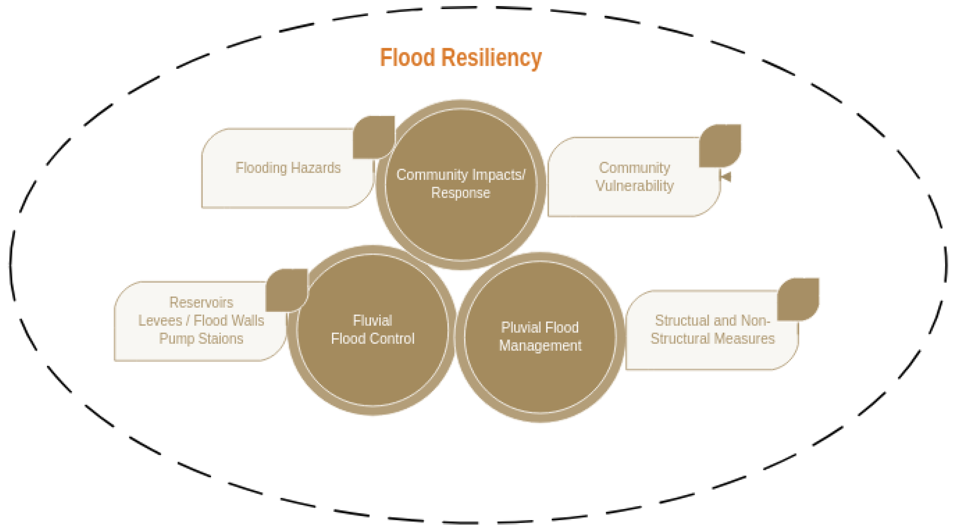
3. Evolution of Flood Management Practices

3.1. Fluvial Flood Control

Early flood mitigation efforts were largely focused on controlling the harmful effects of flooding on humans and were based on the notion that flooding, while inevitable, could be fully controlled. Flood control projects were largely structural in nature and involved building large-scale facilities to store flood waters and both delay and attenuate the flood wave to protect downstream communities. Even today, riverine flood-control structures provide the first line of defense against flood waters arising from upstream areas. These structures include reservoirs, levees, flood walls, and pump stations.
Reservoirs are constructed across a river and usually have extra free-board and sluice-and-gate mechanisms to control flooding. Levees are earthen embankments built alongside rivers to prevent water from overflowing. River walls serve the same function as levees but are often built from concrete. Pump stations are used to pump excess water that is flowing out of the levees or flood walls and pump that water back into the river.
Despite several flood control projects being undertaken, flooding continues to be a problem in many parts of the world [18]. Building new or scaling up existing flood control infrastructure is cost prohibitive and highly dependent upon the quality of hydrologic information that is available at the site [19,20]. Increased climate variability also adds uncertainty with regards to hydrological information and makes scale-up of existing projects challenging [21].

3.2. Pluvial Flood Management

With increased urbanization, the impacts of pluvial flooding became significant. There was growing recognition that controlling fluvial flooding alone was insufficient and humans and the environment must be protected from pluvial flooding. Flood management now sought to create an environment where humans could learn to live with floods. Retention and detention basins, culverts and green infrastructure such as rain gardens, bioswales, blue roofs, and enhanced infiltration systems (e.g., permeable pavement) prevent flood water from accumulating in residential areas [22,23]. In a similar vein, non-structural measures, such as zoning laws that restrict development in flood-prone areas, increasing public awareness, and employing early-warning systems to evacuate people to safer areas are also utilized [24,25,26]. Rather than keeping the flood waters away from humans (as is the case with flood control), flood management also sought to keep humans away from flooding hazards. This approach of flood management was largely based on the notion of identifying the susceptibility of a land parcel to flooding (e.g., 100-year floodplain) and using that information to keep people away from flooding impacts through structural and non-structural measures [27].
While coastal and riparian areas are prone to flooding, they also offer several other significant opportunities, such as access to water-based trade routes, fishing and aquaculture operations, and enhanced recreation activities. The number of people living in coastal areas has increased substantially over the last few decades, with nearly 40% of the world’s population residing within 100 km of the coast [28] and over 50% of the population within a few kilometers of a water body [29]. Flood insurance programs provide safety net for people susceptible to flooding damages. These programs rely on risk assessments to evaluate the probability of a flood hazard that a person and/or infrastructure is exposed to in developing insurance policies and setting premiums.
While flood risks have been defined in multiple ways, using both qualitative and quantitative measures, a widely used definition views flooding as a product of hazard, value, and vulnerability [30]. Hazard characterizes the threatening event, including its probability of occurrence; the values (or values at risk) denote humans, infrastructure, and other assets that are present at a location; and vulnerability is the lack of resistance to damaging forces of the hazard-causing event. Flood risk management uses the risks of flooding hazards as the basis for management and seeks to develop structural and non-structural measures that mitigate the effects of hazards to acceptable levels of risk [25].

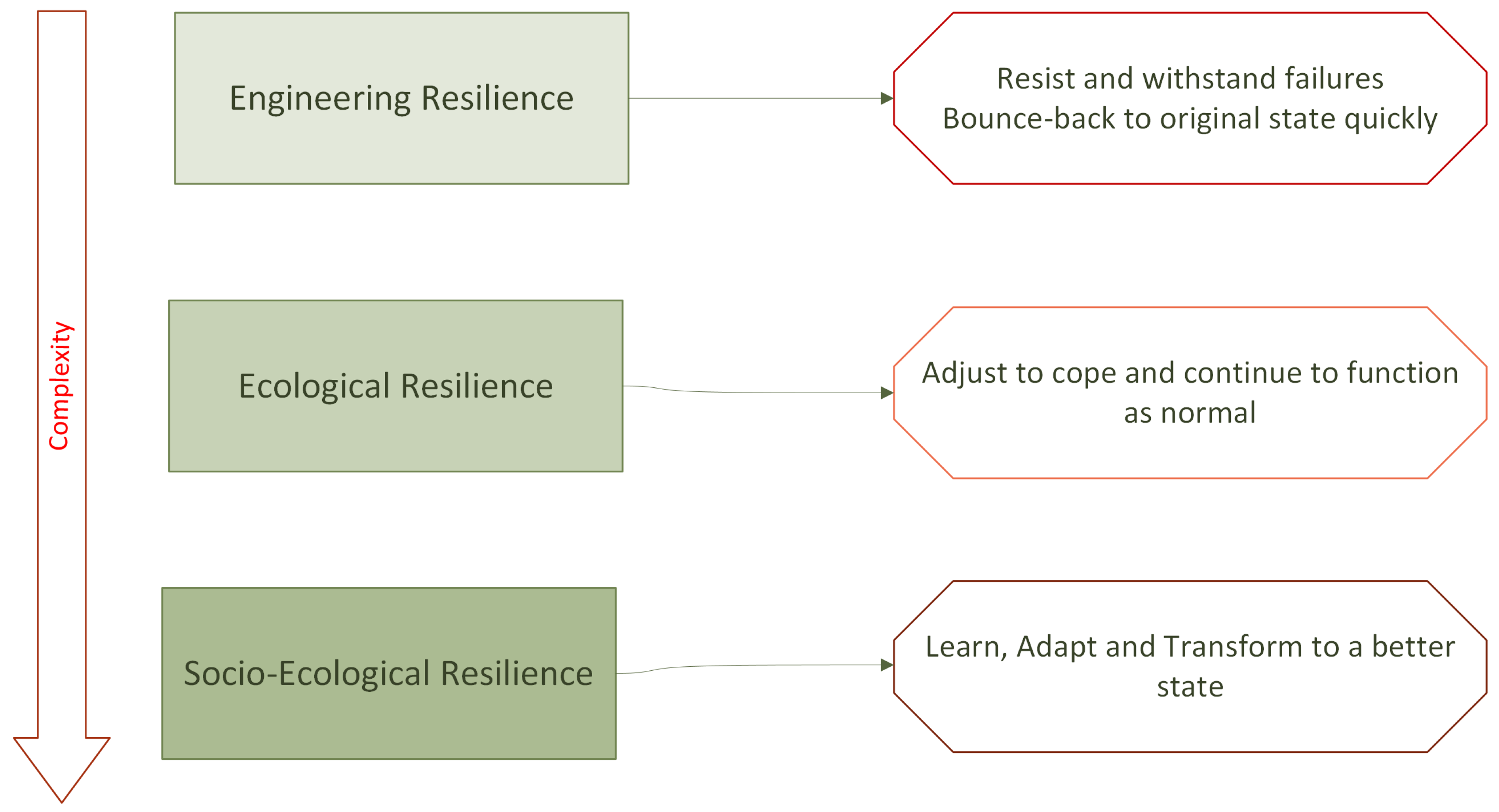
3.3. Resiliency-Based Flood Management

While floods cause damage to both humans and the environment, they are important for sustaining river and floodplain ecosystems. Floods transport fine sediment and energy, required for riverine flora and fauna. In addition, the disturbances created by flood and droughts are essential for fostering ecological biodiversity [31,32]. The ecological importance of floods is no longer a theoretical construct but has been integrated with reservoir operations for flood control [33]. Flood management is transitioning from human-centric approaches towards more holistic frameworks [34].
The recognition of the importance of flooding for the functioning and sustainability of vibrant riparian ecosystems coupled with the inadequacy of flood control strategies, and the movement of flood mitigation from being a command–control-type engineering endeavor to a more stakeholder-driven, participatory, community-based effort has brought to light the concept of flood resiliency. While the definitions of flood resiliency continue to evolve [35], the synthesis of resiliency definitions from a wide range of disciplines provided in [36] has seen widespread usage in resiliency-based flood management studies [37,38]. In this approach, flood resiliency approaches are categorized into three types: (1) Engineering resiliency; (2) ecological resiliency; and (3) socio-ecological resiliency (see Figure 2). While the words engineering, ecological, and socio-ecological are used in this approach, they are not domain-specific and have been used in diverse systems and applications [37].
The main idea of engineering resilience is to create systems that can withstand hazards and not fail. If and when failure occurs, these systems need to bounce back to their original (pre-flooding) stage quickly. The traditional design of hydraulic infrastructure is based on the idea of engineering resiliency. The concept of the return period (or the average time of recurrence of a flooding event of a certain magnitude or higher) is used for design of structures that aim to control floods (dams and levees), mitigate their effects (detention and retention basins), or otherwise interact with floods (e.g., bridges), and it is suitable for use in single systems [39].
The ecological resilience is typically applied to a system with multiple interconnecting parts. This allows the system to adjust and cope with flooding hazards. For example, early-warning systems allow people to procure supplies in advance and take other precautionary measures (e.g., evacuate to a higher elevation) to cope with short-term floods. Socio-ecological resilience focuses on complex adaptive systems (or a system of systems). Here the system may not come back to its original state but adapts and transforms to a better state. For example, relocation of people out of the floodplains to areas with lower inundation risks is often undertaken after devastating hurricanes [40].
It is important to recognize that flood resiliency is not independent of flood control and flood risk management approaches. Rather, the resiliency paradigm subsumes both the flood control and flood risk management concepts. From this viewpoint, the resiliency provided by flood control and risk-based structural and non-structural alternatives is evaluated and improved upon in most flood resiliency endeavors so as to benefit from past investments in flood planning and course-correct in light of new information [38]. While the goal of any flood planning endeavor is to minimize the risks of flooding to humans and the environment, socio-ecological resiliency-based planning and management challenges one to think outside the box and evaluate whether converging to a new equilibrium is better (or worse) than trying to return to the original state.
Regardless of the methodology adopted, flood management is a costly endeavor that requires considerable investments in infrastructure, and a time-consuming process, where diverse and often conflicting views and values have to be reconciled effectively.

4. Physics-Based Models for Flood Management

Quantitative information is paramount to flood management. Estimates of runoff, streamflows, the nature and extent of inundation, and the frequency and magnitudes of extreme rainfall are therefore a major component of flood management endeavors. It is not only important to analyze historical floods but also develop robust estimates for future conditions, especially given the recognition that past climate is not necessarily a good indicator of future flooding events [41].
Mathematical models used for flooding can be categorized as (1) white-box models, (2) gray-box models, and (3) black-box models. White-box models are the most rigorous and employ mass, energy, and momentum conservation principles. Gray-box models are based on the conservation-of-mass principle, along with empirical laws to describe flooding. Black-box models are completely empirical and built on site-specific data.
Both white-box and gray-box models are referred to physics-based models as they are based on physical principles. The development and application of these models dates back at least 100 years [42]. Physics-based models can be developed for a wide range of systems, such as streams and rivers, watersheds, reservoirs, and wetlands. In addition, they can be developed to study combined interactions like climate–hydrology dynamics [43], human–water linkages [44], and the food–energy–water nexus [45].
Flood planning studies often employ more than one model. For example, a conceptual hydrological model can be used to model fluvial flood discharges into a stream, while a hydraulic routing model can be used to study fluvial flooding. When multiple models are used, they can be loosely coupled (meaning the two models are separately run) or tightly coupled (one software allows running of all the models with seamless data transfer between them). The application of physics-based models entails many aspects. Salient modeling considerations are presented in Table 1.
Several software simulators have been developed by various agencies to support flood management. Widely used software simulators are presented in Table 2. A wide range of engineered and natural systems pertaining to flood control can be modeled using these software at varying levels of complexity.

Physics-Based Models—Pros and Cons

Physics-based models offer several advantages. They are built on well-established laws such as mass conservation, which are universally applicable. In addition, these principles also offer numerical checks to ensure that the model has been coded correctly. Physics-based models have been in existence for several decades now and many studies have been carried out to evaluate the suitability of such models in simulating flood characteristics. In addition, there are several use cases and best practices related to their calibration and evaluation [46]. Software simulators such as HEC-RAS, HEC-HMS, and SWAT are well maintained and improved to exploit the benefits of current technologies, such as their integration with GIS and ability to pull in data from the web. The principles behind these models are also taught in fundamental engineering classes, along with software-specific training modules that are widely available. These models are known to capture major flooding characteristics and provide physically plausible explanations [47] and therefore have regulatory acceptance [48].
While physics-based models offer great theoretical rigor, their implementation is challenging on several fronts. Physics-based models contain model inputs that cannot be directly measured. These parameters have to be estimated indirectly from available observations. The process of obtaining unknown model inputs using observed outputs is called the inverse problem in mathematics or calibration in the hydrologic literature. The inverse problem is mathematically ill-posed and therefore does not yield unique solutions. In other words, different subsets of model inputs can result in similar output predictions [49]. Typically, available hydrologic records at most sites only allow reliable estimation of a few parameters [50]. Efforts to improve model calibration have focused on using expert knowledge to guide calibration [51] and/or regularization schemes that seek to restrict the number of calibration parameters during calibration [52,53], using other surrogate information [53] to guide calibration, and using ensemble methods [54] to construct confidence bounds by employing parallel computing approaches [55]. However, these improvements still largely remain in the theoretical regime and are not widely used in routine flood management studies. An analysis of the sensitivity and uncertainty of model outputs due to uncertainty and variability of inputs is recommended to understand the limitations of estimates of factors like inundation obtained from physics-based models [56].
As physics-based models require calibration, their usage in ungauged basins becomes even more challenging due to a lack of long-term output data [57]. Regionalization approaches are often employed to overcome this limitation. Calibrated data from nearby and/or similar systems are scaled for use in the ungauged basin [58,59]. Scaling of hydrological phenomena is however non-trivial and the success of regionalization depends upon the amount of informative content that is present to facilitate scaling [60]. Nesting ungauged watersheds within gauged watersheds is beneficial if the gauging density of the larger watershed is sufficiently high [61].
The ability of physics-based models to capture flood peaks is also of concern. This limitation stems from several factors: (1) Most flood models operate on a time-step of days or months due to availability of rainfall records at those scales. However, flooding is a much more dynamic phenomenon that causes changes in flows on the order of minutes to hours. The coarse temporal discretization limits the ability of the model to capture fine-scale changes [62]. Models make several other approximations to simulate various hydrological processes, these simplifications capture general trends well but cannot adopt to sudden changes in flow regimes [63]. (2) The root mean square error (RMSE), or its variant the Nash–Sutcliffe Efficiency (NSE), are widely used for model calibration. Minimization of this metric entails a trade-off in capturing a large number of low-flow events and relatively few high-flow events, which often leads to over-estimation of low flows and under-estimation of peak flows. The use of newer error metrics like the Kling–Gupta Efficiency (KGE) [64] can ameliorate this impact [65]. (3) The amount of data available also impacts the ability to capture peak flows [66]. Clearly, errors in flood forecasts induce uncertainty in flood planning and management.

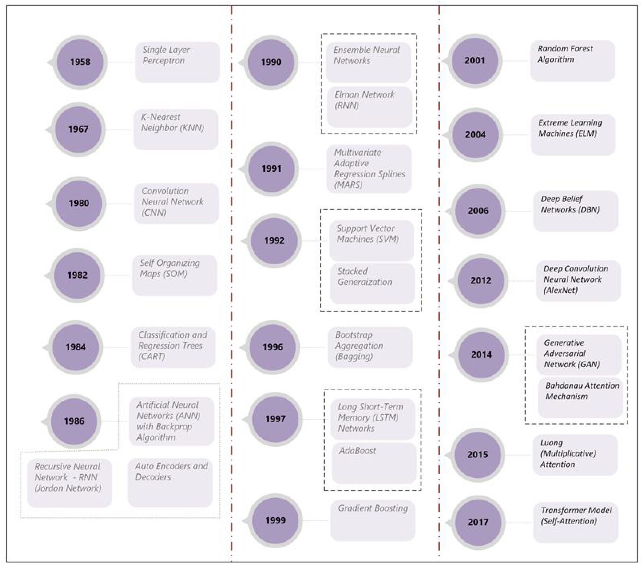
5. Machine Learning Modeling—Background

The limitations associated with physics-based formulations coupled with recent and rapid advancements in artificial intelligence (AI) and machine learning (ML) have increased the exploration of machine learning methods in applications focused on flood management. Machine learning models are not new, the term was coined by Arthur Samuel back in the year 1959 [67]. A timeline of major advancements in machine learning is presented in Figure 3. Algorithms developed in the 1960s, such as K-nearest neighbors (KNN), are in use even today [68].
Artificial neural networks (ANNs) have been around at least since the mid-1980s and some of the early applications of this technique for streamflow forecasting date back to the early 1990s [69,70]. In a similar vein, an early application of tree-based learners for flood studies can be traced all the way back to 1992 [71]. The number of applications of machine learning models steadily increased from the 1990s to the 2010s, congruent with algorithmic developments in this period.
In recent years, the number of papers has grown exponentially given the large-scale availability of data, general purpose libraries such as Scikit Learn [72] and Tensorflow [73], as well as many libraries such as caret [74], nnet [75], and randomforest [76] in R [77] and deep learning and reinforcement learning toolboxes in Matlab [78]. Computational power has also increased significantly in the last decade with the availability of graphical processing units (GPUs) and Tensor Processing Units (TPUs) on some platforms. Unlike conventional central processing units (CPUs), GPUs support parallel floating point operations (FLOPs), speeding up large-scale computations. TPUs utilize a grid of parallel processing elements through which computations are processed in a synchronous manner.
While the use of machine learning models is on the rise, it is important to note that they have their own set of limitations: (1) They are empirical and not generally not based on physical principles; (2) they are subject to overfitting, which means they can learn the noise in the data and therefore cannot generalize the results; (3) some methods offer high predictive accuracy but do not explain the underlying processes (therefore are black-box models); (4) they often require large quantities of data, which may not be available at all sites; (5) their performance not only depends upon the available data, but also is influenced by parameters used in their parameter estimation methods (i.e., hyper-parameters). Therefore, prior to reviewing the use of machine learning for flood management, a brief overview of major learning strategies employed is presented to highlight important features and contextualize their utility in flood management studies.

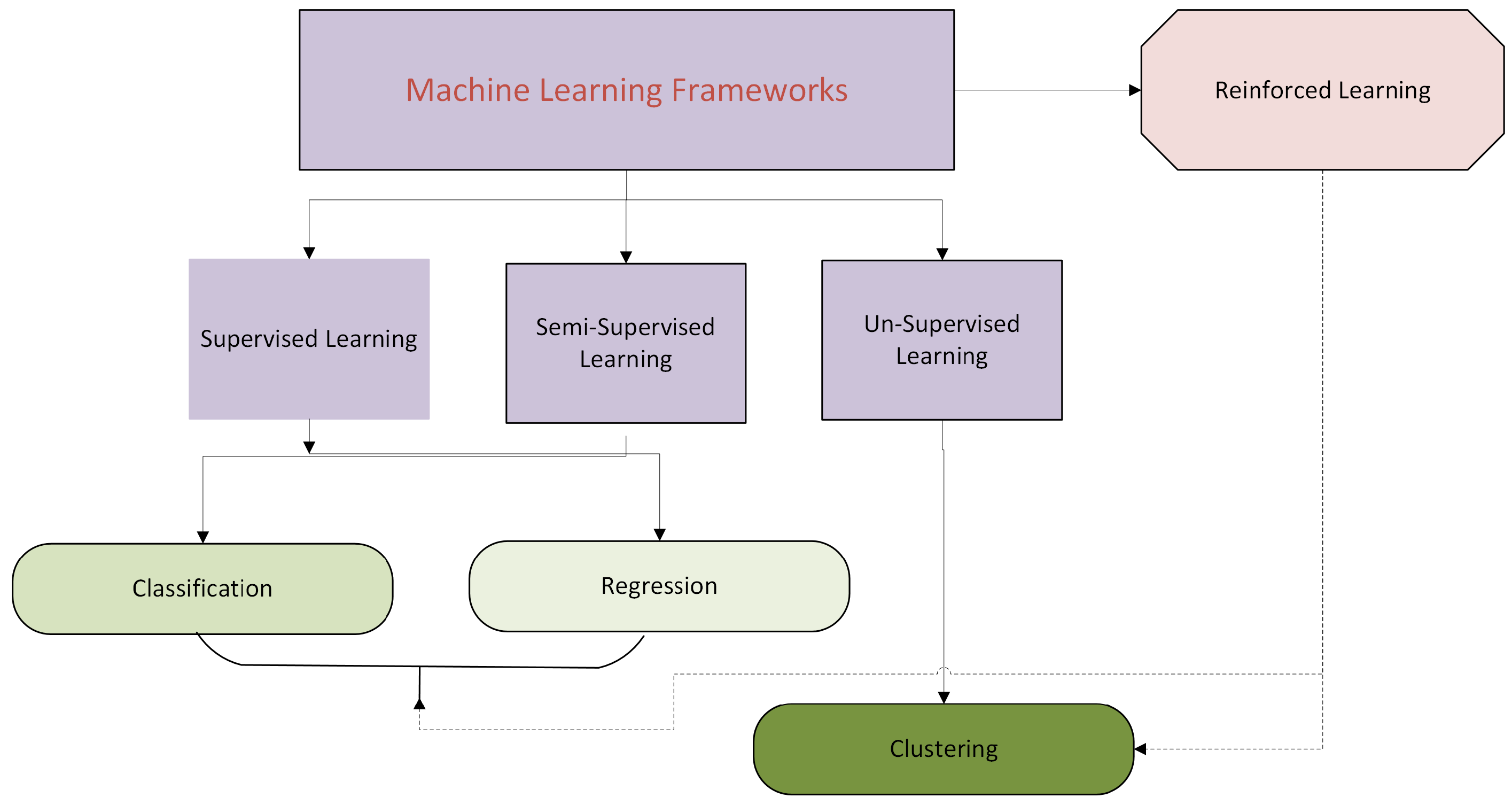
5.1. Machine Learning Strategies

As shown in Figure 4, the four main types of ML are supervised learning, semi-supervised learning, unsupervised learning, and reinforcement learning. In supervised learning, an ML model is trained using a dataset that has both the inputs (features) and the output (labels). Outputs can be continuous or discrete. Supervised learning methods that employ discrete labels are referred to as classifiers, while those mapping continuous labels are called regressors. Unsupervised learning, on the other hand, is trained on a dataset that has no labels and is often used to cluster data. Semi-supervised learning uses a dataset where there are some data with labels and others without labels. This approach can be used for both classification and regression tasks. Reinforcement learning (RL) focuses on developing a long-term (operating) policy that maximizes long-term reward; while RL algorithms can in theory be used for classification, regression, and clustering tasks, they are not specifically designed with these applications in mind, but are better suited for decision making and control [79].
Humans use different approaches to learn information. Cognitive approaches focus on using past experiences and knowledge for making decisions and solving new problems. These strategies can range from simple memorization of facts to forming rules of thumb to guide decisions. In a similar vein, humans also decide when to learn what information, and evaluate competing pieces of information to make a decision based on the weight of the evidence provided by them. Human decision making is not always individualistic but involves collaboration (bagging) with peers and partners. Humans also exhibit the ability to build and improve on their previous experiences (boosting). Machine learning models that try and mimic the cognitive capabilities of humans can be categorized as cognitive-inspired machine learning (CIML) approaches.
Biological adaptations modify how stimuli (data) are sent to the brain (central processing unit) and how they are processed to create new information. Evolutionary changes happen over longer time scales and change the biological makeup to improve survival. On shorter timescales, humans (living beings) also exhibit the ability to change their physical and neurological conditions to adapt to new conditions, learn new skills, or adapt to a new environment. In particular, the brain can reorganize and form new neural connections—this phenomenon is referred to as neuroplasticity and is a key mechanism by which the brain adapts to new information and environments.
Neuroplasticity plays a key role in memory and mortar learning, helps in recovery from brain injuries, and is controlled by the nature of the stimuli [80]. Machine learning models that mimic evolution and/or the structure of the nervous system and the functioning of the brain can be categorized as biologically inspired machine learning (BIML) models.
A variety of machine learning models have been developed over the last seven decades (see Figure 4). Learning strategies provide a quick way to understand the broader ideas related to machine learning algorithms. Table 3 provides a grouping of machine learning algorithms based on their learning styles.
More than one learning strategy presented in Table 3 can be adopted for a given task such as mapping nonlinear input–output relationships.

5.2. Calibration of Machine Learning Models

Machine learning models are empirical in nature, therefore the model parameters are unknown and have to be determined via calibration, particularly in the case of supervised learning. In unsupervised learning, there is no calibration per se, but distances between points within a cluster are minimized while the distance between two independent clusters is simultaneously optimized. While physics-based models are often calibrated using both automatic (optimization-based) and manual methods, machine learning models are calibrated almost exclusively using automatic optimization-based methods. In case of supervised classification, an error metric, such as the root mean square error (RMSE), is minimized. The objective function that is minimized is commonly referred to as the loss function in the machine learning literature. Similarly, the calibration of the supervised learning model is referred to as training the model.
Typically, the calibration of a supervised ML model is carried out by splitting the available dataset into two parts. The first part is called the training dataset, which is used to train the model, and the second part is the testing dataset. The training dataset is used to obtain unknown model parameters (e.g., weights of neural network) by minimizing a loss function. The performance of a model is then assessed by comparing the model predictions against the testing dataset that contains data that the model has not seen before. ML model algorithms also have a set of parameters that are necessary to define the structure of the model or to implement the optimization routines necessary for model calibration. These parameters are called ‘hyper-parameters’.
Hyper-parameters can be set based on previous studies, but most often are estimated (optimized) during the calibration process. When hyper-parameters are optimized as part of the training process, the training dataset is further divided into two parts: training dataset and validation dataset. The training dataset is used to train the model; the validation data is initially used to test the performance of the training under a given set of hyper-parameters and select their optimal values. Once the hyper-parameter values are identified, the validation dataset is subsumed into the training dataset and a final training is performed on the model. Validation datasets are also useful for early stopping (i.e., when the validation error increases even when the training error is decreasing as training progresses). Similarly, the validation dataset can be used to select the best model for a subset of models or use the validation error metrics to weigh different models within an ensemble.
Typically, the dataset is randomly split into training and testing subsets. In the case of sequential data (e.g., time series), the first part of the data is used for training while the latter part of the data is kept aside for testing. Train–testing splits of 70%–30% or 80%–20% are common. Typically, 10%–20% of the training data is used for validation.
Overfitting occurs when a model is able to predict the training data very well but demonstrates a rather poor performance on the testing (independent) dataset. Overfitting generally implies the model has more degrees of freedom (parameters) than necessary. Thus, the model is able to learn the noise in the data rather than focus on generalization. Overfitting can also occur with hyper-parameters. The validation dataset is used to avoid overfitting of hyper-parameters. Regularization methods are widely used to prevent overfitting: a regularization function adds a penalty with increasing weights, which causes the model to effectively drop some weights during the calibration to reduce the penalty on model performance. Overfitting is more likely in deep neural network models due to their complexity and more aggressive approaches such as dropout (where certain nodes are dropped from training with a certain probability) are used to prevent overfitting.
Training of supervised learning models typically occurs by sending small batches of data through the model to adjust weights. Each run with a model is called a training epoch. The stochastic gradient descent algorithm (SGD) is commonly used for model calibration [81]. Automatic, or algorithmic, differentiation (AD) is widely used to compute gradients without significant numerical errors [82]. These gradients are used to identify newer estimates of parameters which reduce the loss function to the lowest possible value. However, in deep neural networks, the gradients of weights of early layers practically become zero (i.e., vanish), making training using conventional gradient descent ineffective. Greedy learning uses layer-by-layer training to eliminate the effects of vanishing gradients and effectively train deep networks. Greedy learning approaches are also used in other ML models such as random forests and gradient boosting methods [83].

5.3. Explainable Machine Learning

While machine learning models can provide accurate predictions and map highly nonlinear input–output relationships, interpretability of the models is a major limitation. In this regard, physics-based models and statistical models (e.g., linear regression) perform much better as the model equations and parameters can be readily interpreted.
Explainable machine learning (XAI) is a rapidly emerging field of ML that seeks to improve the understanding of the inner workings of ML models. XAI provides several benefits, most important of which is the increased trust in using these models in mission-critical applications such as flood forecasting. XAI also helps evaluate if the model is based on biased data and helps debug the models and improve their work.
Some AI techniques such as CART, MARS, and genetic programming (GP) encode information in the data as rules and equations and therefore are readily interpretable. As boosting and bagging methods create multiple models with the same dataset, the relative importance of different parameters can be ascertained even if the model equations are not explicitly known per se. Tree-based algorithms are also used to explain other hard-to-interpret models [84].
Neural network models (particularly deep learners) encode the information in terms of weights that are hard to interpret. In such cases, the outputs obtained from the model are explained by fitting local (explainable) models around the predictions: Shapley Additive Explanations (SHAP), which uses game theoretic measures to explain the importance of different features on the output, and Local Interpretable Model-Agnostic Explanations (LIME), based on linear regression around the predictions, are commonly used to explain which inputs are important and how they affect a particular model output [85].
Having presented a broad overview of machine learning methods, the application of these techniques in flood risk management is explored next.

6. Machine Learning for Flood Resiliency

6.1. Machine Learning for Fluvial Flood Control

6.1.1. Machine Learning for Reservoir Operations

Reservoirs store excess water during high-flow events and release them during periods of high demand. The controlled release of flow out of the reservoir is to ensure there is minimal downstream hazards, but also is constrained by the capacity of the reservoir and associated infrastructure. Therefore, the outflow of the reservoir is a function of the water height in it. Reservoir operation rules (RORs) are used to define outflows. Operation rules tend to be complex, especially when there are multiple interconnected reservoirs, and they are only known to a few practitioners.
Machine learning models have been used to infer reservoir operating rules and predict outflows. A wide range of machine learning approaches, including artificial neural networks (ANNs), Support Vector Machines (SVMs), random forest (RF), deep neural networks (DNNs), and recurrent networks, especially the long short-term memory (LSTM) network, have been adopted for this purpose [86,87,88,89,90,91,92,93].
The main conclusion of these studies is that machine learning models provide better predictions than conventional tools (e.g., statistical models such as ARIMA or water-balance formulations). Deep learners, especially LSTM and GRUs (gated recurrent units) provide better predictions than other techniques in most, if not all, cases. However, there is no universal consensus on which model always provides the best results. Different models may perform well at different sites within a river basin. Therefore, assessment must always include multiple models to select the optimal model of those tested.
Reservoir inflows are a key input to these models and the quality of the output depends upon the quality of the inflow data. Note that reservoir inputs can be natural streamflows or controlled releases from an upstream reservoir (these reservoirs may or may not be explicitly modeled). While treating upstream reservoir releases as inputs simplifies the outflow predictions at a downstream reservoir, explicitly modeling the releases of these upstream reservoirs is shown to improve model predictions due to better accounting for lag times of flows [94].
Most studies focus on modeling monthly or daily outflows, although efforts are beginning to be made to develop sub-daily streamflow time series to improve streamflow forecasts [95]. Most models provide 1-step-ahead forecasting, with many providing 2-, 3-, and multi-step-ahead forecasts. Real-time forecasting is also being attempted using machine learning [96].
Statistical metrics such as the root mean square error (RMSE) are used as the objective (loss) function to minimize the errors between observed and modeled outflows. However, recent efforts have focused on including other information to help guide the calibration process. A mass-conserving LSTM (mc-LSTM) model has been presented as well [97]. Loss functions have been modified to include conservation relationships as well as other information such as reservoir operation rules [93,98].
While recurrent and non-recurrent neural networks (e.g., LSTM, GRUs, and ANNs) appear to provide better forecasts than most other models, the derived operational rules are abstracted as weights and thus not readily interpretable. This issue, if not of concern in forecasting, is the only goal of the model. However, interpreting the model results and which inputs have a bigger impact on the output is useful to evaluate the performance of ML models (especially those that behave like black boxes).
Scenario-based sensitivity analysis, and XAI methods like Shapley Additive Explanations (SHAP) are being employed to understand how ML model inputs affect reservoir outflows [98,99]. The results from these studies suggest that while XAI results make hydrological sense in most situations, there is no guarantee of this over the entire range of outputs [99]. An evaluation of whether ML models trained with physics-based or operation-based loss functions explain the results better is an interesting but unexplored direction of research.
Reservoir inflows are critical to properly predict outflows. In forecasting applications, reservoir inflows have to be estimated to make future predictive runs.
Therefore, considerable interest also exists in using machine learning for modeling reservoir inflows [100,101,102,103,104,105,106,107,108,109,110,111,112,113,114,115,116]. These models mainly focus on a daily time-step, but both monthly and sub-daily time-steps need also be predicted depending upon the requirements of the problem.
The modeling of reservoir inflows using machine learning bring about several distinct insights: (1) These models use meteorological variables such as precipitation, temperature, and wind speed and their lags. (2) Atmospheric teleconnections such as El Nino–Southern Oscillation (ENSO), the North Atlantic Oscillation (NAO), the Pacific Decadal Oscillation (PDO), the Indian Ocean Dipole (IOD), and the Arctic Oscillation (AO) are also being employed. These teleconnections correlate with several reservoir inflow processes such as rainfall, evapotranspiration, and snowmelt. (3) There is a greater propensity to combine multiple models rather than rely on a single algorithm such as LSTM. (4) Rather than utilize an ensemble mean (EM), most studies utilize a stacking ensemble (SE), wherein different parts of the dataset are predicted by different model subsets. This occurs because some models provide very high extreme values which bias the overall ensemble mean. (5) It is more common to see fused traditional and deep machine learning algorithms as well as statistical models such as ARIMA for reservoir inflow forecasts.
Reservoir inflow estimation is often fraught with uncertainty. These uncertainties can be random due to changing weather patterns, land-use alterations, and climate change. The ability of a model to capture extremely high inflows is critical in flood management applications. While ML models may perform better than traditional physics-based models for forecasting streamflows, they are not perfect nor without limitations. Model stacking and ensemble approaches may help with predictions, but also can potentially average down extreme forecasts. Explicitly capturing this uncertainty alongside point estimates adds value to the estimation process as it informs the decision-maker of which are more likely estimates and what are plausible values. Therefore, many studies have explored the use of uncertainty quantification methods such as Bayesian deep learning, Bayesian networks, fuzzy logic, and other heuristic models [51,89,100,114,115,117].
Despite a growing number of publications in this area, propagating uncertainties in reservoir inflows through single- and multi-reservoir operations is clearly a largely unexplored direction and of considerable practical significance.

6.1.2. Levees and Flood Walls

Levees and flood walls are structures built along a river to keep flood waters from flowing into the adjoining floodplain. While levees and flood walls serve similar purposes, the former are built using earthen materials, while the latter are built using concrete.
While applications of machine learning algorithms to study levees are limited (see Table 4), they have tackled the most challenging problems related to the resiliency of levees to withstand failure. Machine learning has been used to evaluate failure risk due to overtopping, compaction and liquefaction, and piping. Cracks and other early-warning signals, such as the formation of sand boils, which indicate piping due to liquefaction, have also been studied. Manual inspection and ground-penetrating radar (GPR) are two common approaches to evaluate hazards in these systems. Both of them are expensive and time-consuming; therefore automated detection using drones and transfer learning algorithms to enhance the value of limited GPR-based surveys have also been explored using machine learning methods. Deep neural networks such as convolution neural networks (CNNs) and the Viola–Jones object detection method, which is based on the boosting technique, have shown promise for evaluating drone-based surveys. Conventional neural networks such as ANN, SVM, Naive Bayes, and others have been useful to predict the risk of failures.
Table 4. Machine learning modeling focused on levees.
FocusMethodDataReference
Levee overtoppingLogistic regressionGeometric, hydraulic geotechnical[118]
Levee anomaliesAdaBoost; Viola–Jones detectorField inspection data[119]
Failure hazardsDeep learnerElectrical resistivity data[120]
Hazard classificationClusteringUAV, geophysical (shear velocity, EMI, apparent resistivity)[121]
Levee compactionDeep transfer learning, ANN, KNN, NB, LR for predictionTransfer learning for feature dataset[122]
Sand boilsStack of ML algorithms (SVM, ANN, CNN)Field surveys (images)[123]
The United States alone has over 24,000 miles of levees and the average age of these levees is 51 years [124]. As such, many of the levees are in need of rehabilitation and most levees were not designed for modern climatic conditions. The review of the literature indicates that while attempts have been made to evaluate levee failure risks using machine learning, this is another largely unexplored area as far as flood resiliency is concerned.
The National Levee Database (NLD, 2025) [124] provides the best publicly available information to understand levee performance. Efforts to compile a larger dataset of images pertaining to levee failures, along with their hydraulic, geotechnical, and geophysical characteristics, would be a useful addition to facilitate further research in this area.

6.1.3. Pumping Stations for Flood Control

Pumping stations offer the third line of defense in flood control. Pumps are used to remove any excessive water and pump it back into the river. Machine learning has been utilized to model this system. Lee and Lee (2022) utilized multi-layer perceptrons (ANNs) to simulate the discharge from pumping stations using previous rainfall and discharges [125]. They concluded that while the method was useful, the study could have benefited from having inflow data into the pump stations as one of the inputs. Wang et al. (2023) [126] applied ANNs and SVMs with different evolutionary optimization techniques to study inflows into a pumping station for different time periods. They made use of water levels at other pumping stations, rainfall, and human factors to develop different models that showed a high degree of accuracy in their study area. Kow et al. (2024) [127] utilized a Transformer-based LSTM (T-LSTM) to abstract pump station operating rules using rainfall and flows from upstream stations. The use of Transformers assisted in capturing the seasonality in the operations and provided excellent results, both for typhoon and convective storm events. Joo et al. (2024) [128] combined gated recurrent units (GRUs) with deep-Q reinforcement learning to simultaneously minimize water levels in a retention basin and the number of pump switches over the entire storm duration. Their results indicate that this combination is useful to improve operations of pump networks used in flood control.
While traditional methods for operating pump stations using physics-informed models and traditional optimization routines continue to be used [129], efforts have started on exploring the use of machine learning models for predicting inflows, outflows, and the operation of these pumping stations. Pump stations help reduce flooding risks to humans and the environment but can also cause changes to local hydrology as well as affecting riparian and riverine habitats due to changes in dissolved oxygen [130]. Therefore, proper operation of these systems is critical. While the use of machine learning shows great promise, the lack of open-source datasets limits the number of researchers who have access to such data, which in turn hinders a deeper exploration of this topic.

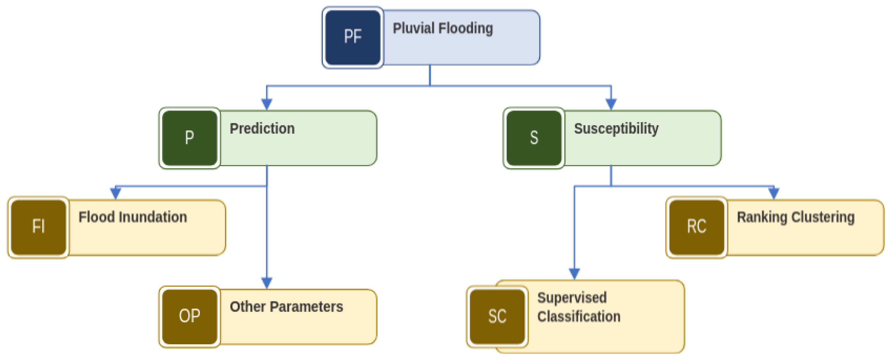
6.2. Machine Learning for Pluvial Flood Management

6.2.1. Pluvial Flood Estimation

Machine learning methods have been widely used in pluvial flooding studies [131,132,133,134,135,136,137,138,139,140,141,142,143,144,145,146,147,148,149,150,151,152]. Figure 5 explains the primary goals of these machine learning models in pluvial flooding studies. These studies either focus on predictions of flood characteristics or susceptibility mapping of flood-prone areas, mostly in urban environments.
The analysis of the literature pertaining to the use of machine learning for pluvial flooding demonstrates that a wide range of machine learning methods have been used in various applications. Among the traditional machine learning methods, the logistic regression (LR), artificial neural network (ANN), support vector machine (SVM), and K-nearest neighbors (KNN) algorithms show greater use. Ensemble methods such as random forest (RF) and XGBoost have also been used extensively. Among the deep learning algorithms, convolution neural networks (CNNs) stand out prominently. While all these models provide good results, there is no clear identification of which one is best.
ML based Classification methods are used to predict flood/no-flood zones using a suite of inputs such as precipitation, land-use type, elevation, and others. The labels (output) are obtained either from observed data within an urban area that is collected by municipalities and/or from those reported by citizens through navigation apps such as WAZE. The latter is useful for understanding flood-prone roads and other transportation infrastructure.
Unsupervised methods, such as fuzzy clustering, have been used to categorize an area’s susceptibility to flooding. Such classifications can help data collection activities to develop supervised classifiers in the future. The depth of the water level in urban areas following a rainfall event as well as the extent of inundation in floodplains are also important aspects of pluvial flooding. As urban areas are typically ungauged, this information has to be obtained via simulation or using satellite remote sensing [153,154,155].
Machine learning methods have been widely used to abstract the results from physics-based models (i.e., flooding depth, inundation extent), using surrogate measures such as rainfall intensity, land elevation, and other characteristics. Again, a suite of conventional and deep learners have been employed for this purpose that have yielded good results. Once trained, machine learning models are easier to run and different scenarios can be evaluated to guide flooding planning and emergency management efforts. However, as ML models depend upon data from physics-based models, their accuracy cannot be greater than those obtained via physics-based simulators. Therefore, integrating physics-based simulations with satellite data can improve prediction methods, especially using interferometric synthetic-aperture radar (InSAR) and other remote sensing products. A case study of such integration is presented in [155].
One important aspect of pluvial flooding is the heterogeneity of datasets. For example, rainfall hyetographs are 1D temporal data, while digital elevation models are 2D (raster data), and high-water marks are points in 2D space (vector data). Simulation models can produce 1D or 2D data in space and over time. Transportation infrastructure is usually multi-line data (line vectors). Assimilation of such data from diverse sources is an important ancillary topic that is beginning to be explored [156,157].
Estimation of pluvial flooding characteristics, particularly inundation depth and extent, using physically based tools is rather difficult due to the paucity of data for model validation. While several studies have demonstrated that the output of such models can be captured using machine learning methods, the ability to transfer such learning to other sites via transfer learning approaches is another interesting area that has received little attention [158] and offers significant opportunities to improve flood risk management in other areas. In a similar vein, while the use of explainable artificial intelligence (XAI) methods such as SHAP has been demonstrated in the literature [141], their usage is still limited and offers significant potential to eludicate factors affecting pluvial flood risks.

6.2.2. Machine Learning Approaches for Low-Impact Development

Low-impact development (LID) aims to develop stormwater infrastructure within urban areas that largely mimic natural hydrology by enhancing infiltration, supporting vegetation, and enhancing water quality. In many US cities, it is part of the Municipal Separate Storm Water Systems (MS4) and permitted to discharge water from urban areas to natural water bodies. Environmental permits not only emphasize the rate and volume of discharges but also place restrictions on the quality of the discharged water. Therefore, contaminants of concern (CoCs) often control their design and operation even if their primary goal is to remove flood water from roads, residential neighborhoods, and business districts, and keep pluvial flood waters away from humans.
Machine learning models are being used to design and operate many LID features and understand their functioning. Complex physics-based formulations can be approximated using machine learning and used with multi-objective optimization for sizing LID practices [159]. This approach greatly reduces the computational time to obtain optimal solutions.
Deep reinforcement learning is widely being used to operate (control) stormwater treatment systems to mitigate flood flow rates and associated contaminant movement. Reinforcement learning is noted to help achieve real-time control under uncertainty [160,161,162].
Integration of machine learning with other ancillary technologies such as the Internet of Things (IoT), physical-model simulations, and remotely sensed datasets opens new avenues to model the performance of stormwater systems, develop better designs, and monitor LID systems [163,164]. Emerging studies indicate the promise of such integration, and this is another fertile area for further exploring the role of machine learning.
Predictions of water quality outflows from LID stormwater systems is of interest to decision-makers to ensure they are within compliance. Machine learning models have found uses in capturing and correlating highly complex water quality transformations occurring within LIDs to easily measured surrogate data such as rainfall, temperature, sunlight, and others. A variety of modeling algorithms have been evaluated and demonstrated to provide good results. The algorithms tested include, but are not limited to, ANN, SVM, KNN, random forest, generalized linear models (GLMs), partial least squares (PLS), and deep learners [165,166,167,168,169].
While ML models show high potential to predict water quantity and quality parameters in stormwater control and treatment systems, there is no single approach that stands out. The quality of predictions varies among models, so experimentation with a candidate set of models is often required. Conventional machine learning models (ANN, SVM) perform better than deep learners in some cases, especially when the amount of data available for calibration and testing is small. In addition to variability across models, a particular algorithm may be better suited for one water quality parameter but not another. This result indicates that some ML schemes are able to better assimilate certain processes that affect the quality of stormwater than others. However, the success of ML models in predicting emerging contaminants, such as microplastics, indicates their high potential to predict concentrations of contaminants for which the mechanisms of biochemical transformations are not completely known [169].
While ML algorithms show promise for modeling urban stormwater infrastructure, there are many unexplored research directions. The use of explainable machine learning (XAI) in understanding the predictions of ML models, especially to understand the fate and transport of emerging contaminants, has the potential to develop fundamental insights on pollutant behavior using machine learning. Evaluating the use of stacked and ensemble learning methods, and integrating physics-informed loss functions, are some easy implementations that have not been undertaken to date to the best of the authors’ knowledge and offer some useful avenues to explore.

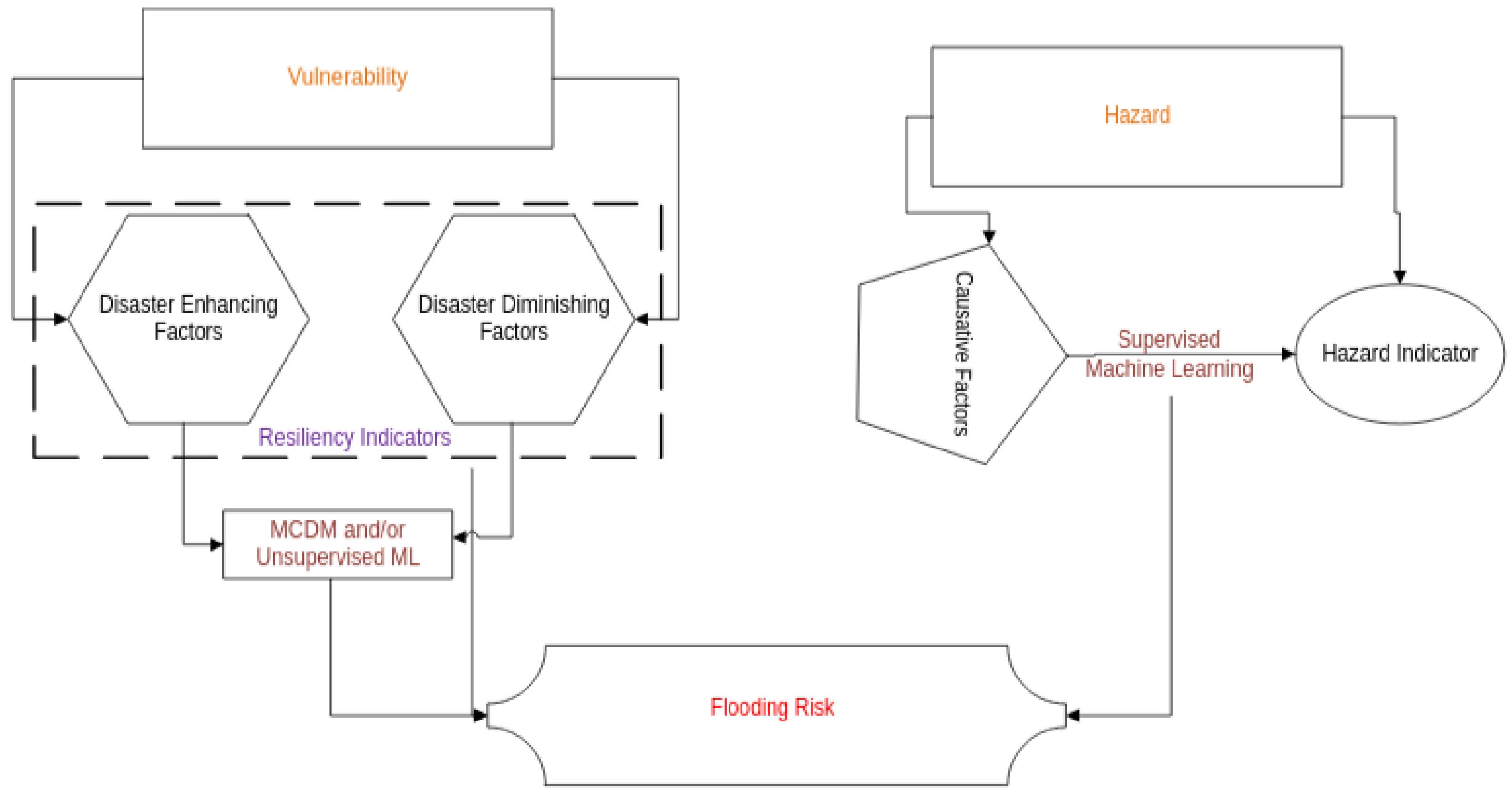
6.3. Machine Learning and Flood Resiliency

A significant amount of research focused on the resiliency of communities to flooding risks has begun to emerge in the last few years and a large sample of such studies, particularly those using machine learning approaches, is summarized in Table 5. The synthesis of these studies depicts common themes, which are presented in Figure 6.
Resiliency is measured as the extent of vulnerability of a community to withstand a flooding hazard. The higher the vulnerability, the lower the resiliency of the community. Vulnerability captures demographic, economic, geographic, and engineering factors, such as the population density, the nature and extent of economic activity, land elevation, and distance from flooding features, such as streams, and engineering measures, such as pumping stations and other stormwater conveyance features.
Table 5. Summary of studies focused on flooding risk and resilience.
CitationMethods UsedFocus/Findings
[170]AHP, GIS, RS, and ML (random forest and SVM)Community resilience of floods; ML for susceptibility analysis.
[171]CNN to extract features for flood resilience + fuzzy logic for Resilience IndexResistance, functional, and economic resilience explicitly modeled.
[172]SOM compared with PCAEconomic, physical, and social dimensions of vulnerability considered.
[173]SVM, ANN, RF, GBDT; stacking and ensemble not superiorMeteorological, geographic, and human resilience explicitly considered.
[174]Unsupervised, supervisedCategorize resilience and predict using rainfall.
[175]Different clusteringResilience defined in terms of robustness and rapidity.
[176]NB, LR, RF, Lazy Tree, ANN (RF provided the best results)Predicts 4 classes—flood, flash flood, coastal flood, and lakeshore flood.
[177]Ensemble methods, random forestFlood risk is product flood susceptibility based on weights of evidence and flood hazard maps.
[178]SVM, XGBoost, RF, MLP GBDT, 1DCNNDisaster-inducing factor, disaster-breeding element, disaster-bearing bodies (input); deeper models not as useful as shallower models.
[179]SVM + MCDMSVM for flood susceptibility; MCDM for flood vulnerability.
[180]Random forest was the best; SVM and boosted regression treesTOPSIS for vulnerability; ML for hazard; output—various levels of risk.
[181]Tree-based approaches with DEADEA for integrating socio-economic and adaptive capacity indicators (vulnerability); ML with geomorphology for susceptibility.
[182]XGB, RF, CatBoost—RF was the best modelSusceptibility in riverbeds; geomorphology for mapping susceptibility.
[183]GARP and MaxEntHazard (flood, economic, social) x Hazard (flood hazard—based on field survey and ML).
[184]ANN and linear regressionLandscape factors affecting flood susceptibility (satellite for flood hazards; role of LULC via regression).
[185]Text mining, clustering and predictionRole of big data, IoT, and social media data—flood risk mapping; rapid impact assessment on infrastructure failure; smart situational awareness; more conceptual study with application to Harris County.
[186]Random forest and SVM; Multiple MCDM methodsEnsemble of MCDM and ML models for an aggregated Flood Susceptibility Index.
[187]MCDM + deep neural networks; SHAP-based XAINational flood risk insurance data, flood risk map. Improved risk at finer spatial levels.
[188]CART, MARS, BRT, SVM, and linear discriminant analysisVulnerability using AHP (MCDM); flood hazards via ML. Different criteria used for vulnerability and hazards.
Multi-criteria decision-making (MCDM) approaches are used to aggregate such factors into a composite index. A suite of MCDM approaches, such as simple additive weighting (SAW), analytic hierarchy process (AHP), VIKOR, ELECTRE, and others have been utilized for this purpose (see [189,190] for an overview of these techniques). Briefly, MCDM aggregates ratings, which describe an alternative’s concordance with a criterion, and criteria weights, which denote the relative importance of the criterion, and aggregates the scores over all selected criteria to rank and prioritize alternatives. Uncertainty is an integral component of such an analysis and therefore some studies have attempted to use fuzzy set theory to capture differences among decision-makers with regards to different criteria and ratings of alternatives.
Note that MCDM is an unsupervised approach wherein each alternative is ranked (so the number of initial clusters equals the number of alternatives). Once ranked, the grouping of these alternatives can be carried out subjectively or using unsupervised classification methods such as clustering and self-organizing maps (SOMs).
While vulnerability captures the likely impact (or lack thereof) of floods at a given location. The hazard posed by the flood also varies geographically. This risk arises because of hydrologic conditions, such as rainfall intensity, and also land-use land-cover (LULC) conditions that lead to runoff (flood) generation. The risk of flooding of a land parcel depends upon several factors including, but not limited to, rainfall intensity, duration, LULC, soil types, antecedent moisture conditions, and topographic slopes. Supervised machine learning models are used to develop relationships between flooded areas and other surrogate measures to model flooding hazards. A variety of approaches have been used to obtain flooded areas including, but not limited to, use of satellite imagery, household surveys, topography-based wetness indices, and subjective or anecdotal information of decision-makers. Clearly, the more direct the measurement, the more reliable the result. A suite of machine learning modeling including, but not limited to, ANN, SVM, CART, MARS, random forest, boosting methods (GBT, XGBoost, AdaBoost), and deep learning have been employed for these purposes and have been demonstrated to be able to model flood hazards with a high degree of accuracy.
The data volume available for modeling is often limited, which in turn favors conventional ML methods over deep learning paradigms. Some researchers have also utilized ensemble and stacking of algorithms, with varying degrees of success. The suitability of ensemble methods is hampered by the large predictive variability across different models. While most of the explanations of the ML modeling results are provided using tree-based approaches, Shapley Additive Explanations (SHAP) has also been used with deep learning models. While most models have focused on binary (flood/no flood) classification, multinomial models, to capture varying levels of hazard, have been explored to a limited extent.
Copula-based approaches are widely used to estimate joint and conditional risks of flood intensity, volume, and duration [191,192]. However, the integration of these approaches with machine learning is another poorly explored area of research. The coupling of ML and copula approaches to study droughts is demonstrated in [193], indicating the possibility of such an effort for flooding as well. Unlike droughts, which depend upon atmospheric variables (rainfall and temperature), estimation of flood duration, volume, and intensity is only possible in gauged catchments, and the flood indicators also depend on soil type, antecedent moisture, land use, and other factors, whose temporal variability is not known in many locations.
Flood hazard assessment in many areas is hampered by a paucity of data. This is particularly true not only in developing countries but also in rural and peri-urban areas of developed nations. Transfer learning provides one way to overcome this limitation, where a model trained over a larger dataset in a similar region is used to make predictions in another. In addition, several other emerging technologies provide useful information to understand flooding hazards and vulnerability. The Internet of Things (IoT) is bringing about new, low-cost technologies for monitoring both fluvial and pluvial floods [194,195,196]. Low-cost sensors have the potential to significantly increase the data that are available for flood mapping. While such sensors increase the data availability, they generally have poorer data quality and are prone to giving erratic results. Therefore, data cleaning becomes necessary and machine learning algorithms for detecting and removing outliers can be useful [197]. In addition, several machine learning models, both conventional and deep, can be used for real-time forecasting and enhancing the flood early-warning capabilities of downstream communities. While the integration of the IoT and machine learning or early-warning systems has been demonstrated in some areas [198], there is still considerable opportunity to explore this area, particularly in terms of data retrieval (using drones) when internet infrastructure may become non-functional due to floods.

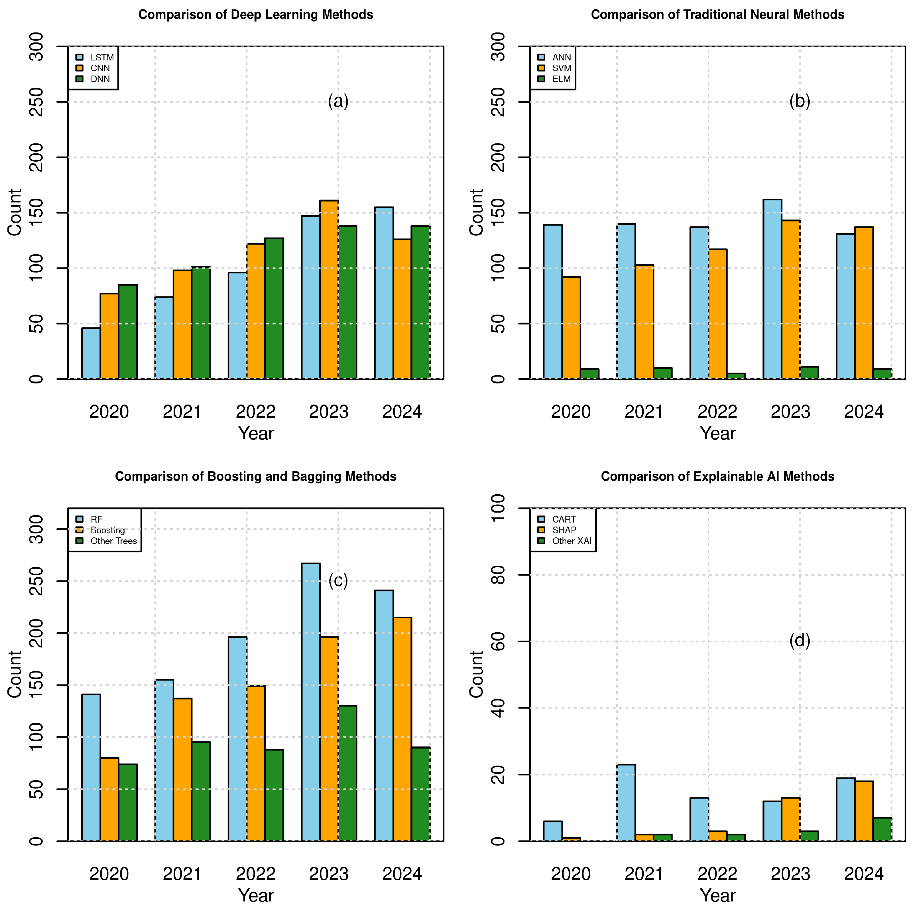
7. Trends in Machine Learning Model Usage

The literature above indicates that machine learning models are being widely used across the spectrum of flood assessment and management applications. As machine learning models are empirical, most studies often assess two or more techniques to identify a suitable model. Sometimes the models are integrated into an ensemble and their average prediction is used as the most likely estimate. Regardless, understanding the trends in usage is important to identify whether some models are preferred over others or if some models are not being favored. To address this question, the number of peer-reviewed articles pertaining to each machine learning technique related to flood studies was obtained from the OpenAlex database [199].
The results, shown in Figure 7, reveal some interesting trends: The use of deep learning methods, particularly LSTM and CNN, has grown considerably. CNN is more widely used than LSTM because it can be used with both spatially and temporally structured sequences, while LSTM is specifically designed to deal with 1D datasets. There has also been a steady increase in the number of publications using other deep network (DNN) architectures such as autoencoders and decoders. Despite the growth in deep learning models, traditional neural networks (with a single hidden layer) are also used quite extensively. In particular, traditional neural methods integrate well with GIS and multi-criteria decision-making methods. Also, they serve as a useful benchmark to evaluate whether deep learners offer better results for a given flood application. In terms of tree-based learning, while the use of both random forest and boosting methods has increased in the last five years, random forest is slightly more preferred compared to boosting techniques. In particular, random forest algorithms have been used not just for predictions but also for feature importance, although feature importance can be deduced from boosting methods as well. The preference for bagging methods likely arises from their simplicity and generalization ability. The random forest algorithm has only two hyper-parameters (number of trees and maximum depth). On the other hand, boosting methods have a greater number of hyper-parameters (e.g., shrinkage, regularization, and number of estimators) and therefore are harder to tune and more prone to overfitting. Bagging operations can be carried out in parallel while boosting methods are sequential in nature. Therefore, bagging methods can make use of multi-core and multi-threading capabilities when working with large datasets. These advantages explain the greater use of random forest over boosting techniques. Finally, Figure 7d shows the number of explainable AI (XAI) publications. As can be seen, this is a burgeoning area of research with a lot of potential for increased usage.

8. Future Directions

The review demonstrates how machine learning (ML) is playing an important role across the gamut of flood applications. Not only are the number of papers published concerning it on the rise, but its applications are not limited to one type of problem. The review also highlights some key gaps and future research directions, which are enumerated below:
  • While the use of machine learning for pump station operations has been demonstrated, the number of studies is limited due to paucity of data. Efforts to develop other open-source datasets would be useful to further test the use of ML in real-time operations of flood control pumps.
  • With the advent of the Internet of Things (IoT), data will be collected at a much faster pace than before. However, the quality of data that many low-cost sensors provide may have a high degree of uncertainty. Therefore, the use of machine learning for data filtering (e.g., the use of autoencoders/decoders) and infilling of missing data needs to be evaluated.
  • Many sensors have enough computational power to not only collect data but also perform other computations. Edge computing approaches have a very important role in developing early-warning and real-time flood forecasting tools. Again, the integration of machine learning with hardware components for edge computing appears to be a promising area of research, particularly for pluvial flooding.
  • Flooding infrastructure such as levees spans over large distances. As these structures age, it is imperative to rehabilitate them before the occurrence of a catastrophic event. Expensive and error-prone human-based inspections are slowly being replaced by drone-based surveying. Large-scale image processing and anomaly detection are critical areas where machine learning use has been limited but has significant potential.
  • Advances in parallel and distributed computing services are expected to continue in the next few years. The potential of machine learning to serve as a backend for comprehensive visualizations based on virtual, augmented, and mixed realities offers significant potential to not only improve our understanding of floods but also help citizens and communities improve resiliency to better withstand flooding hazards and promote flood-informed development.
  • Machine learning models have a great role to play in assimilating data from general circulation models and downscaling them. ML approaches that can lead to more robust estimates and tackle non-stationarity need to be developed for climate-adaptive decision making.
  • The ability to generate synthetic datasets and augment limited measurements (e.g., high-water marks) provides new opportunities to utilize satellite, LiDAR, and visual observations to map pluvial flooding hazards. This requires integration of several machine learning technologies and assimilation of multiple datasets at various resolutions.
  • Ensemble models are often noted to have poor predictive capabilities due to large deviations in their predictions. Development of better tools to average ensemble models via integration of Bayesian and information-theoretic approaches could help develop new tool sets for flood applications.
  • Integrating machine learning methods with physics-based modeling can be doubly advantageous. Physics-based models can infuse theoretical underpinnings to ML models while machine learning algorithms can learn nonlinear processes not captured by physics-based formulations. Physics-informed machine learning can lead to solutions where the output is greater than the sum of the parts.
  • Soil moisture and land conditions play a very significant role in pluvial flooding, Machine learning approaches can play a significant role in predicting soil moisture due to its nonlinear dynamics. Machine learning models that help exploit available, albeit limited, soil moisture data in conjunction with physically based modeling is another largely unexplored direction that could help improve flood prediction and early warning.
  • The potential of reinforcement learning approaches has not been explored to the fullest extent. Reinforcement learning models can be used to manage flood control releases from flood detention basins by integrating both volume, flow rate, and water quality constraints.
  • Machine learning models have been widely used for predicting flood flows and volumes. Floods also cause changes to water quality, with grave ecological and environmental consequences. While some efforts to use machine learning for flood control have been undertaken, the development of multi-task machine learning models capable of predicting both flow and quality would be extremely beneficial but is largely unexplored at this stage.

9. Closing Remarks

Flooding is a complex problem that causes widespread damage across the world. It is now clear that flooding hazards cannot be completely eliminated using engineering measures alone. People have to live with floods. Flood control measures must not only focus on in-stream controls but also utilize structural and non-structural alternatives within an urban area to mitigate pluvial flooding to protect humans and also help mitigate downstream fluvial impacts. Despite keeping humans away from flood waters and managing them as necessary, the threats of flooding continue to grow unabated due to changes in climate, and population growth and concomitant urbanization. Therefore, the current thinking goes a step further and evaluates how humans and the environment of a region are at risk of flooding and what are the best strategies to absorb the shocks of flooding and rebound to a better (or at least to the pre-flooding) state. The idea of withstanding the harmful effects of flooding to the greatest possible extent (robustness) and rebounding back to a better state as quickly as possible (rapidity) is called resiliency-based flood management.
Resiliency-based flood management is not independent of flood control measures for minimizing fluvial and pluvial flooding, rather it takes a more holistic point of view in identifying the risks that exist within a region and using this knowledge to guide future growth that is flood-informed and also identify vulnerable targets that need immediate attention to bring the system back to normalcy. Thus, resiliency is not simply an engineering or land-planning and zoning endeavor but involves every one in the community contributing towards flood-proofing.
Machine learning models are widely used in flood studies, ranging from flood control to resiliency-based management. The usage is higher in those applications where data are readily available. Advances in remote sensing and drone-based data collection and the proliferation of low-cost sensors using the Internet-of-Things (IoT) will further expand its role in many other aspects of floods that are currently hampered by data limitations. While these technologies show promise, their full potential is yet to be explored [200]. While machine learning offers great prediction and forecasting abilities, there is no single universally acceptable method, so empirical experimentation with multiple models is necessary. This aspect should not be viewed as a weakness but exploited to learn more about the functioning of the models and what is making them better predictors (or not). Explainable AI (XAI) methods are useful in this regard and should be adopted to transition ML models from black-box forecasters to better-informed and knowledge-based predictors.
In closing, machine learning models offer exciting approaches to tackle the entire gamut of flood problems. They are useful supplements to traditional physics-based modeling tools. Efforts should be made to integrate these two techniques to improve our forecasting capabilities as well as interpreting flooding phenomena from multidimensional perspectives. Machine learning can be used to control and operate flood control and stormwater management infrastructure and improve understanding and the resiliency of communities to flooding hazards. This requires close collaboration between flood managers, civil engineers, and hydrologists as well as the computer scientists and mechanical and electrical engineers who build sensor technologies. Machine learning offers a common language for bringing transdisciplinarity to flooding studies.

Author Contributions

Conceptualization, V.U. and E.A.H.; methodology, E.A.H. and V.U.; formal analysis, V.U. and E.A.H.; investigation, E.A.H. and V.U.; resources, V.U. and E.A.H.; data curation, E.A.H.; writing—original draft preparation, V.U.; writing—review and editing, E.A.H.; visualization, E.A.H. and V.U.; supervision, E.A.H.; project administration, V.U. All authors have read and agreed to the published version of the manuscript.

Funding

This research received no external funding.

Conflicts of Interest

The authors declare no conflicts of interest.

Abbreviations

The following abbreviations are used in this manuscript:
No.AbbreviationFull Form
11D-CNNOne-dimensional convolutional neural network
2ADAutomatic or algorithmic differentiation
3AdaBoostAdaptive Boosting
4AHPAnalytic hierarchy process
5AIArtificial intelligence
6ANNArtificial neural network
7AOArctic Oscillation
8ARIMAAutoregressive Integrated Moving Average
9BIMLBiologically inspired machine learning
10BRTBoosted Regression Tree
11CARTClassification and Regression Tree
12CatBoostCategorical Boosting
13CBRCase-based reasoning
14cGANConditional generative adversarial network
15CIMLCognitive-inspired machine learning
16CNNConvolution neural network
17CoCsContaminants of concern
18DBNsDeep belief networks
19DEAData Envelopment Analysis
20DNNDeep neural network
21DSDiversity sampling
22ELECTREElimination and Choice Translating Reality
23ELMExtreme Learning Machine
24EMEnsemble mean
25EMIElectromagnetic induction
26ENSOEl Nino–Southern Oscillation
27GANGenerative adversarial network
28GARPGenetic Algorithm Rule-Set Production
29GBDTGradient Boosting Decision Tree
30GISGeographic Information System
31GLMGeneralized linear model
32GPGenetic programming
33GPRGround-penetrating radar
34GRUGated recurrent unit
35HEC-HMSHydrologic Engineering Center-Hydrologic Modeling System
36HEC-RASHydrologic Engineering Center-River Analysis System
37InSARInterferometric Synthetic Aperture Radar
38IODIndian Ocean Dipole
39IoTInternet of Things
40KGEKling–Gupta Efficiency
41KNNK-nearest neighbors
42LIDLow-impact development
43LIMELocal Interpretable Model-Agnostic Explanations
44LRLogistic regression
45LSTMLong short-term memory
46LULCLand Use–Land Cover
47MARSMultivariate Adaptive Regression Splines
48MaxEntMaximum entropy
49MCDMMulti-criteria decision making
50mc-LSTMMass-Conserving long short-term memory
51MIMOMulti-input multi-output
52MLMachine learning
53MLPMulti-layer perceptron
54MS4Municipal Separate Storm Sewer System
55NAONorth Atlantic Oscillation Index
56NBNaïve Bayes
57NLDNational Levee Database
58NSENash–Sutcliffe Efficiency
59PCAPrincipal component analysis
60PDOPacific Decadal Oscillation
61PLSPartial least squares
62QBCQuery by committee
63RFRandom forest
64RLReinforcement learning
65RMSERoot mean square error
66RNNRecursive neural network
67RORsReservoir operation rules
68RSRemote sensing
69SAWSimple additive weighting
70SEStacking ensemble
71SGDStochastic Gradient Descent
72SHAPShapley Additive Explanations
73SOMsSelf-Organizing Maps
74SVMsSupport Vector Machines
75SWATSoil and Water Assessment Tool
76SWMMStorm Water Management Model
77T-LSTMTransformer-based long short-term memory
78UAVUnmanned aerial vehicle
79USACEUnited States Army Corps of Engineers
80USDAUnited States Department of Agriculture
81USEPAUnited States Environmental Protection Agency
82XAIExplainable artificial intelligence
83XGBoostExtreme Gradient Boosting

References

  1. Kreibich, H.; Dimitrova, B. Assessment of damages caused by different flood types. WIT Trans. Ecol. Environ. 2010, 133, 3–11. [Google Scholar] [CrossRef]
  2. USDHS2025. United States Department of Homeland Security-Natural Disasters. 2025. Available online: https://www.dhs.gov/archive/natural-disasters (accessed on 25 July 2025).
  3. Ruan, X.; Sun, H.; Shou, W.; Wang, J. The impact of climate change and urbanization on compound flood risks in coastal areas: A comprehensive review of methods. Appl. Sci. 2024, 14, 10019. [Google Scholar] [CrossRef]
  4. Tabari, H. Climate change impact on flood and extreme precipitation increases with water availability. Sci. Rep. 2020, 10, 13768. [Google Scholar] [CrossRef]
  5. Saghafian, B.; Farazjoo, H.; Bozorgy, B.; Yazdandoost, F. Flood intensification due to changes in land use. Water Resour. Manag. 2008, 22, 1051–1067. [Google Scholar] [CrossRef]
  6. Maranzoni, A.; D’Oria, M.; Rizzo, C. Probabilistic mapping of life loss due to dam-break flooding. Nat. Hazards 2024, 120, 2433–2460. [Google Scholar] [CrossRef]
  7. Thiemig, V.; Salamon, P. European Flood Awareness System (EFAS). JRC106774 Dataset. 2017. Available online: https://european-flood.emergency.copernicus.eu/en (accessed on 20 July 2025).
  8. Montalvo, C.; Reyes-Silva, J.; Sañudo, E.; Cea, L.; Puertas, J. Urban pluvial flood modelling in the absence of sewer drainage network data: A physics-based approach. J. Hydrol. 2024, 634, 131043. [Google Scholar] [CrossRef]
  9. Okoli, K.; Mazzoleni, M.; Breinl, K.; Di Baldassarre, G. A systematic comparison of statistical and hydrological methods for design flood estimation. Hydrol. Res. 2019, 50, 1665–1678. [Google Scholar] [CrossRef]
  10. Yan, B.; Mu, R.; Guo, J.; Liu, Y.; Tang, J.; Wang, H. Flood risk analysis of reservoirs based on full-series ARIMA model under climate change. J. Hydrol. 2022, 610, 127979. [Google Scholar] [CrossRef]
  11. Latif, S.; Mustafa, F. Copula-based multivariate flood probability construction: A review. Arab. J. Geosci. 2020, 13, 132. [Google Scholar] [CrossRef]
  12. Wong, W.; Lee, M.; Azman, A.; Rose, L.; Teknousahawan, F. Development of Short-term Flood Forecast Using ARIMA. Int. J. Math. Model. Methods Appl. Sci. 2021, 15, 68–75. [Google Scholar] [CrossRef]
  13. Soares, J.A.; Ozelim, L.C.; Bacelar, L.; Ribeiro, D.B.; Stephany, S.; Santos, L.B. ML4FF: A machine-learning framework for flash flood forecasting applied to a Brazilian watershed. J. Hydrol. 2025, 652, 132674. [Google Scholar] [CrossRef]
  14. Ghorpade, P.; Gadge, A.; Lende, A.; Chordiya, H.; Gosavi, G.; Mishra, A.; Hooli, B.; Ingle, Y.; Shaikh, N. Flood forecasting using machine learning: A review. In Proceedings of the 2021 8th International Conference on Smart Computing and Communications (ICSCC), Kochi, India, 1–3 July 2021; pp. 32–36. [Google Scholar]
  15. Mosavi, A.; Ozturk, P.; Chau, K. Flood prediction using machine learning models: Literature review. Water 2018, 10, 1536. [Google Scholar] [CrossRef]
  16. Ferrari, R. Writing narrative style literature reviews. Med. Res. 2015, 24, 230–234. [Google Scholar] [CrossRef]
  17. Pollock, A.; Berge, E. How to do a Systematic Review. Int. J. Stroke 2018, 13, 138–156. [Google Scholar] [CrossRef]
  18. Kundzewicz, Z.; Su, B.; Wang, Y.; Xia, J.; Huang, J.; Jiang, T. Flood risk and its reduction in China. Adv. Water Resour. 2019, 130, 37–45. [Google Scholar] [CrossRef]
  19. Ramirez, J.; Adamowicz, W.; Easter, K.; Graham-Tomasi, T. Ex post analysis of flood control: Benefit-cost analysis and the value of information. Water Resour. Res. 1988, 24, 1397–1405. [Google Scholar] [CrossRef]
  20. García-Ledesma, I.; Madrigal, J.; Domínguez-Sánchez, C.; Sánchez-Quispe, S.; Lara-Ledesma, B. Importance of cost-benefit evaluation in the selection of flood control infrastructures. Urban Water J. 2025, 22, 345–357. [Google Scholar] [CrossRef]
  21. Nguyen, B.; Binh, D.; Tran, T.; Kantoush, S.; Sumi, T. Response of streamflow and sediment variability to cascade dam development and climate change in the Sai Gon Dong Nai River basin. Clim. Dyn. 2024, 62, 7997–8017. [Google Scholar] [CrossRef]
  22. Eckart, K.; McPhee, Z.; Bolisetti, T. Performance and implementation of low impact development–A review. Sci. Total Environ. 2017, 607, 413–432. [Google Scholar] [CrossRef]
  23. Liu, T.; Lawluvy, Y.; Shi, Y.; Yap, P. Low impact development (LID) practices: A review on recent developments, challenges and prospects. Water Air Soil Pollut. 2021, 232, 344. [Google Scholar] [CrossRef]
  24. Nasiri Khiavi, A.; Vafakhah, M.; Sadeghi, S.; Jun, C.; Bateni, S. Comparative effect of traditional and collaborative watershed management approaches on flood components. J. Flood Risk Manag. 2025, 18, 13037. [Google Scholar] [CrossRef]
  25. Grigg, N. Two Decades of Integrated Flood Management: Status, Barriers, and Strategies. Climate 2024, 12, 67. [Google Scholar] [CrossRef]
  26. Thampapillai, D.; Musgrave, W. Flood damage mitigation: A review of structural and nonstructural measures and alternative decision frameworks. Water Resour. Res. 1985, 21, 411–424. [Google Scholar] [CrossRef]
  27. Kaya, C.; Derin, L. Parameters and methods used in flood susceptibility mapping: A review. J. Water Clim. Chang. 2023, 14, 1935–1960. [Google Scholar] [CrossRef]
  28. Reimann, L.; Vafeidis, A.; Honsel, L. Population development as a driver of coastal risk: Current trends and future pathways. Camb. Prism. Coast. Futur. 2023, 1, 14. [Google Scholar] [CrossRef]
  29. Kammu, M.; De Moel, H.; Salvucci, G.; Viviroli, D.; Ward, P.J.; Varis, O. Over the Hills and further away from the coast: Global geospatial patterns of human and the environment over the 20th - 21st centuries. Environ. Res. Lett. 2016, 11, 0304010. [Google Scholar] [CrossRef]
  30. Kron, W. Flood risk = hazard • values • vulnerability. Water Int. 2005, 30, 58–68. [Google Scholar] [CrossRef]
  31. Peters, D.; Caissie, D.; Monk, W.; Rood, S.; St-Hilaire, A. An ecological perspective on floods in Canada. Can. Water Resour. J./Rev. Can. Ressour. Hydr. 2016, 41, 288–306. [Google Scholar] [CrossRef]
  32. Parsons, M. Extreme floods and river values: A social–ecological perspective. River Res. Appl. 2019, 35, 1677–1687. [Google Scholar] [CrossRef]
  33. Owusu, A.; Mul, M.; Zaag, P.; Slinger, J. Re-operating dams for environmental flows: From recommendation to practice. River Res. Appl. 2021, 37, 176–186. [Google Scholar] [CrossRef]
  34. Graha, D.; Yudono, A.; Afrianto, F. IHST (Integrated, Holistic, Spatial, and Thematic) Flood Management Model: The Integration of Flood Model, Green Infrastructure and Non-Structural Mitigation in the Urban Area of Barabai City. IOP Conf. Ser. Earth Environ. Sci. 2024, 1391, 012026. [Google Scholar] [CrossRef]
  35. Laidlaw, S.; Percival, S. Flood resilience: A review of evolving definitions. Nat. Hazards 2024, 120, 10773–10784. [Google Scholar] [CrossRef]
  36. Martin-Breen, P.; Anderies, J. Resilience: A Literature Review; Institute of Development Studies: Brighton, UK, 2011. [Google Scholar]
  37. McClymont, K.; Morrison, D.; Beevers, L.; Carmen, E. Flood resilience: A systematic review. J. Environ. Plan. Manag. 2020, 63, 1151–1176. [Google Scholar] [CrossRef]
  38. Wang, L.; Cui, S.; Li, Y.; Huang, H.; Manandhar, B.; Nitivattananon, V.; Fang, X.; Huang, W. A review of the flood management: From flood control to flood resilience. Heliyon 2022, 8, e11763. [Google Scholar] [CrossRef] [PubMed]
  39. Kafle, A.; Hernandez, E.A.; Uddameri, V. Resiliency of Hydraulic Infrastructure Designs in a Climate Hot-Spot at the Intersection of Two Climate Zones. Nat. Hazard Res. 2025, in press. [Google Scholar] [CrossRef]
  40. Shi, L.; Fisher, A.; Brenner, R.; Greiner-Safi, A.; Shepard, C.; Vanucchi, J. Equitable buyouts? Learning from state, county, and local floodplain management programs. Clim. Chang. 2022, 174, 29. [Google Scholar] [CrossRef]
  41. Liu, S.; Huang, S.; Xie, Y.; Wang, H.; Leng, G.; Huang, Q.; Wei, X.; Wang, L. Identification of the non-stationarity of floods: Changing patterns, causes, and implications. Water Resour. Manag. 2019, 33, 939–953. [Google Scholar] [CrossRef]
  42. Peel, M.C.; McMahon, T.A. Historical development of rainfall-runoff modeling. Wiley Interdiscip. Rev. Water 2020, 7, e1471. [Google Scholar] [CrossRef]
  43. Ning, L.; Zhan, C.; Luo, Y.; Wang, Y.; Liu, L. A review of fully coupled atmpshere-hydrology simulations. J. Geogr. Sci. 2019, 29, 465–479. [Google Scholar] [CrossRef]
  44. Wada, Y.; Bierkens, M.F.; De Roo, A.; Dirmeyer, P.A.; Famiglietti, J.S.; Hanasaki, N.; Konar, M.; Liu, J.; Müller Schmied, H.; Oki, T.; et al. Human–water interface in hydrological modelling: Current status and future directions. Hydrol. Earth Syst. Sci. 2017, 21, 4169–4193. [Google Scholar] [CrossRef]
  45. Miralles-Wilhelm, F. Development and application of integrative modeling tools in support of food-energy-water nexus planning—A research agenda. J. Environ. Stud. Sci. 2016, 6, 3–10. [Google Scholar] [CrossRef]
  46. Moriasi, D.N.; Arnold, J.G.; Van Liew, M.W.; Bingner, R.L.; Harmel, R.D.; Veith, T.L. Model evaluation guidelines for systematic quantification of accuracy in watershed simulations. Trans. ASABE 2007, 50, 885–900. [Google Scholar] [CrossRef]
  47. Vieux, B.E.; Cui, Z.; Gaur, A. Evaluation of a physics-based distributed hydrologic model for flood forecasting. J. Hydrol. 2004, 298, 155–177. [Google Scholar] [CrossRef]
  48. Bodda, S.S.; Gupta, A.; Sewell, R.T. Application of risk-informed validation framework to a flooding scenario. ASCE-ASME J. Risk Uncertain. Eng. Syst. Part A Civ. Eng. 2021, 7, 04021044. [Google Scholar] [CrossRef]
  49. Oreskes, N.; Shrader-Frechette, K.; Belitz, K. Verification, validation, and confirmation of numerical models in the earth sciences. Science 1994, 263, 641–646. [Google Scholar] [CrossRef]
  50. Jakeman, A.; Hornberger, G. How much complexity is warranted in a rainfall-runoff model? Water Resour. Res. 1993, 29, 2637–2649. [Google Scholar] [CrossRef]
  51. Song, J.; Her, Y.; Kang, M. Estimating reservoir inflow and outflow from water level observations using expert knowledge: Dealing with an ill-posed water balance equation in reservoir management. Water Resour. Res. 2022, 58, e2020WR028183. [Google Scholar] [CrossRef]
  52. de Lavenne, A.; Andréassian, V.; Thirel, G.; Ramos, M.; Perrin, C. A regularization approach to improve the sequential calibration of a semidistributed hydrological model. Water Resour. Res. 2019, 55, 8821–8839. [Google Scholar] [CrossRef]
  53. Sun, Y.; Bao, W.; Jiang, P.; Si, W.; Zhou, J.; Zhang, Q. Development of a regularized dynamic system response curve for real-time flood forecasting correction. Water 2018, 10, 450. [Google Scholar] [CrossRef]
  54. Zoccatelli, D.; Wright, D.; White, J.; Fienen, M.; Yu, G. Precipitation uncertainty estimation and rainfall-runoff model calibration using iterative ensemble smoothers. Adv. Water Resour. 2024, 186, 104658. [Google Scholar] [CrossRef]
  55. Asgari, M.; Yang, W.; Lindsay, J.; Tolson, B.; Dehnavi, M.M. A review of parallel computing applications in calibrating watershed hydrologic models. Environ. Model. Softw. 2022, 151, 105370. [Google Scholar] [CrossRef]
  56. Teng, J.; Jakeman, A.; Vaze, J.; Croke, B.; Dutta, D.; Kim, S. Flood inundation modelling: A review of methods, recent advances and uncertainty analysis. Environ. Model. Softw. 2017, 90, 201–216. [Google Scholar] [CrossRef]
  57. Sarchani, S.; Seiradakis, K.; Coulibaly, P.; Tsanis, I. Flood inundation mapping in an ungauged basin. Water 2020, 12, 1532. [Google Scholar] [CrossRef]
  58. Guo, Y.; Zhang, Y.; Zhang, L.; Wang, Z. Regionalization of hydrological modeling for predicting streamflow in ungauged catchments: A comprehensive review. Wiley Interdiscip. Rev. Water 2021, 8, 1487. [Google Scholar] [CrossRef]
  59. Pool, S.; Vis, M.; Seibert, J. Regionalization for ungauged catchments—Lessons learned from a comparative large-sample study. Water Resour. Res. 2021, 57, e2021WR030437. [Google Scholar] [CrossRef]
  60. Blöschl, G.; Sivapalan, M. Scale issues in hydrological modelling: A review. Hydrol. Process. 1995, 9, 251–290. [Google Scholar] [CrossRef]
  61. Neri, M.; Parajka, J.; Toth, E. Importance of the informative content in the study area when regionalising rainfall-runoff model parameters: The role of nested catchments and gauging station density. Hydrol. Earth Syst. Sci. 2020, 24, 5149–5171. [Google Scholar] [CrossRef]
  62. Cerbelaud, A.; David, C.H.; Biancamaria, S.; Wade, J.; Tom, M.; Prata de Moraes Frasson, R.; Blumstein, D. Peak flow event durations in the Mississippi River basin and implications for temporal sampling of rivers. Geophys. Res. Lett. 2024, 51, e2024GL109220. [Google Scholar] [CrossRef]
  63. Neal, J.; Villanueva, I.; Wright, N.; Willis, T.; Fewtrell, T.; Bates, P. How much physical complexity is needed to model flood inundation? Hydrol. Process. 2012, 26, 2264–2282. [Google Scholar] [CrossRef]
  64. Gupta, H.; Kling, H.; Yilmaz, K.; Martinez, G. Decomposition of the mean squared error and NSE performance criteria: Implications for improving hydrological modelling. J. Hydrol. 2009, 377, 80–91. [Google Scholar] [CrossRef]
  65. Mizukami, N.; Rakovec, O.; Newman, A.; Clark, M.; Wood, A.; Gupta, H.; Kumar, R. On the choice of calibration metrics for “high-flow” estimation using hydrologic models. Hydrol. Earth Syst. Sci. 2019, 23, 2601–2614. [Google Scholar] [CrossRef]
  66. Bárdossy, A.; Anwar, F. Why our rainfall-runoff models keep underestimating the peak flows? Hydrol. Earth Syst. Sci. Discuss. 2022, 27, 1987–2000. [Google Scholar] [CrossRef]
  67. Samuel, A. Some studies in machine learning using the game of checkers. IBM J. Res. Dev. 1959, 3, 210–229. [Google Scholar] [CrossRef]
  68. Liu, S.; Liu, R.; Tan, N. A spatial improved-kNN-based flood inundation risk framework for urban tourism under two rainfall scenarios. Sustainability 2021, 13, 2859. [Google Scholar] [CrossRef]
  69. Crespo, J.; Mora, E. Drought estimation with neural networks. Adv. Eng. Softw. 1993, 18, 167–170. [Google Scholar] [CrossRef]
  70. Karunanithi, N.; Grenney, W.; Whitley, D.; Bovee, K. Neural networks for river flow prediction. J. Comput. Civ. Eng. 1994, 8, 201–220. [Google Scholar] [CrossRef]
  71. Hughes, J.; Lettenmaier, D.; Wood, E. An approach for assessing the sensitivity of floods to regional climate change. In AIP Conference Proceedings CONF–9201138; American Institute of Physics: Melville, NY, USA, 1992; Volume 277, pp. 112–124. [Google Scholar]
  72. Pedregosa, F.; Varoquaux, G.; Gramfort, A.; Michel, V.; Thirion, B.; Grisel, O.; Blondel, M.; Prettenhofer, P.; Weiss, R.; Dubourg, V.; et al. Scikit-learn: Machine learning in Python. J. Mach. Learn. Res. 2011, 12, 2825–2830. [Google Scholar]
  73. Pang, B.; Nijkamp, E.; Wu, Y.N. Deep learning with tensorflow: A review. J. Educ. Behav. Stat. 2020, 45, 227–248. [Google Scholar] [CrossRef]
  74. Kuhn, M. caret: Classification and Regression Training. J. Stat. Softw. 2008, 28, 1–26. [Google Scholar]
  75. Ripley, B.D.; Venables, W.N. nnet: Feed-Forward Neural Networks and Multinomial Log-Linear Models, R package version 7.3-18; R Core Team: Vienna, Austria, 2022.
  76. Liaw, A.; Wiener, M. randomForest: Breiman and Cutler’s Random Forests for Classification and Regression, R package version 4.7-1.1; R Core Team: Vienna, Austria, 2002.
  77. R Core Team. R: A Language and Environment for Statistical Computing, Version 4.4.0; R Core Team: Vienna, Austria, 2024.
  78. The MathWorks Inc. MATLAB, version R2024a; MathWorks: Portola Valley, CA, USA, 2024. [Google Scholar]
  79. Kaelbling, L.; Littman, M.; Moore, A. Reinforcement learning: A survey. J. Artif. Intell. Res. 1996, 4, 237–285. [Google Scholar] [CrossRef]
  80. Paraskevopoulos, E.; Anagnostopoulou, A.; Chalas, N.; Karagianni, M.; Bamidis, P. Unravelling the multisensory learning advantage: Different patterns of within and across frequency-specific interactions drive uni-and multisensory neuroplasticity. NeuroImage 2024, 291, 120582. [Google Scholar] [CrossRef]
  81. Robbins, H.; Monro, S. A stochastic approximation method. Ann. Math. Stat. 1951, 22, 400–407. [Google Scholar] [CrossRef]
  82. Gebremedhin, A.H.; Walther, A. An introduction to algorithmic differentiation. Wiley Interdiscip. Rev. Data Min. Knowl. Discov. 2020, 10, e1334. [Google Scholar] [CrossRef]
  83. Dasgupta, S. Analysis of a greedy active learning strategy. Adv. Neural Inf. Process. Syst. 2004, 17. [Google Scholar]
  84. Parimbelli, E.; Buonocore, T.M.; Nicora, G.; Michalowski, W.; Wilk, S.; Bellazzi, R. Why did AI get this one wrong?—Tree-based explanations of machine learning model predictions. Artif. Intell. Med. 2023, 135, 102471. [Google Scholar] [CrossRef]
  85. Belle, V.; Papantonis, I. Principles and practice of explainable machine learning. Front. Big Data 2021, 4, 688969. [Google Scholar] [CrossRef]
  86. García-Feal, O.; González-Cao, J.; Fernández-Nóvoa, D.; Astray Dopazo, G.; Gómez-Gesteira, M. Comparison of machine learning techniques for reservoir outflow forecasting. Nat. Hazards Earth Syst. Sci. Discuss. 2022, 22, 3859–3874. [Google Scholar] [CrossRef]
  87. Castillo-Botón, C.; Casillas-Pérez, D.; Casanova-Mateo, C.; Moreno-Saavedra, L.; Morales-Díaz, B.; Sanz-Justo, J.; Gutiérrez, P.; Salcedo-Sanz, S. Analysis and prediction of dammed water level in a hydropower reservoir using machine learning and persistence-based techniques. Water 2020, 12, 1528. [Google Scholar] [CrossRef]
  88. Latif, S.; Ahmed, A.; Sherif, M.; Sefelnasr, A.; El-Shafie, A. Reservoir water balance simulation model utilizing machine learning algorithm. Alex. Eng. J. 2021, 60, 1365–1378. [Google Scholar] [CrossRef]
  89. Liu, Y.; Qin, H.; Zhang, Z.; Yao, L.; Wang, Y.; Li, J.; Liu, G.; Zhou, J. Deriving reservoir operation rule based on Bayesian deep learning method considering multiple uncertainties. J. Hydrol. 2019, 579, 124207. [Google Scholar] [CrossRef]
  90. Soria-Lopez, A.; Sobrido-Pouso, C.; Mejuto, J.; Astray, G. Assessment of different machine learning methods for reservoir outflow forecasting. Water 2023, 15, 3380. [Google Scholar] [CrossRef]
  91. Qie, G.; Zhang, Z.; Getahun, E.; Allen Mamer, E. Comparison of machine learning models performance on simulating reservoir outflow: A case study of two reservoirs in Illinois, USA. JAWRA J. Am. Water Resour. Assoc. 2023, 59, 554–570. [Google Scholar] [CrossRef]
  92. Al-Nouti, A.F.; Fu, M.; Bokde, N.D. Reservoir operation based machine learning models: Comprehensive review for limitations, research gap, and possible future research direction. Knowl.-Based Eng. Sci. 2024, 5, 75–139. [Google Scholar] [CrossRef]
  93. Chen, R.; Wang, D.; Mei, Y.; Lin, Y.; Lin, Z.; Zhang, Z.; Zhuang, S. A knowledge-guided LSTM reservoir outflow model and its application to streamflow simulation in reservoir-regulated basins. J. Hydrol. 2025, 658, 133164. [Google Scholar] [CrossRef]
  94. Yi, S.; Yi, J. Reservoir-based flood forecasting and warning: Deep learning versus machine learning. Appl. Water Sci. 2024, 14, 237. [Google Scholar] [CrossRef]
  95. Tilloy, A.; Paprotny, D.; Grimaldi, S.; Gomes, G.; Bianchi, A.; Lange, S.; Beck, H.; Mazzetti, C.; Feyen, L. HERA: A high-resolution pan-European hydrological reanalysis (1951–2020). Earth Syst. Sci. Data 2025, 17, 293–316. [Google Scholar] [CrossRef]
  96. Yang, S.; Yang, D.; Chen, J.; Zhao, B. Real-time reservoir operation using recurrent neural networks and inflow forecast from a distributed hydrological model. J. Hydrol. 2019, 579, 124229. [Google Scholar] [CrossRef]
  97. Hoedt, P.; Kratzert, F.; Klotz, D.; Halmich, C.; Holzleitner, M.; Nearing, G.; Hochreiter, S.; Klambauer, G. Mc-lstm: Mass-conserving lstm. In Proceedings of the International Conference on Machine Learning PMLR, Virtual, 18–24 July 2021; pp. 4275–4286. [Google Scholar]
  98. Pokharel, S.; Roy, T.; Admiraal, D. Effects of mass balance, energy balance, and storage-discharge constraints on LSTM for streamflow prediction. Environ. Model. Softw. 2023, 166, 105730. [Google Scholar] [CrossRef]
  99. Fan, M.; Zhang, L.; Liu, S.; Yang, T.; Lu, D. Investigation of hydrometeorological influences on reservoir releases using explainable machine learning methods. Front. Water 2023, 5, 1112970. [Google Scholar] [CrossRef]
  100. Fan, M.; Liu, S.; Lu, D.; Gangrade, S.; Kao, S. Explainable machine learning model for multi-step forecasting of reservoir inflow with uncertainty quantification. Environ. Model. Softw. 2023, 170, 105849. [Google Scholar] [CrossRef]
  101. Sushanth, K.; Mishra, A.; Mukhopadhyay, P.; Singh, R. Real-time streamflow forecasting in a reservoir-regulated river basin using explainable machine learning and conceptual reservoir module. Sci. Total Environ. 2023, 861, 160680. [Google Scholar] [CrossRef]
  102. Rajesh, M.; Anishka, S.; Viksit, P.; Arohi, S.; Rehana, S. Improving short-range reservoir inflow forecasts with machine learning model combination. Water Resour. Manag. 2023, 37, 75–90. [Google Scholar] [CrossRef]
  103. Huang, I.; Chang, M.; Lin, G. An optimal integration of multiple machine learning techniques to real-time reservoir inflow forecasting. Stoch. Environ. Res. Risk Assess. 2022, 36, 1541–1561. [Google Scholar] [CrossRef]
  104. Tian, D.; He, X.; Srivastava, P.; Kalin, L. A hybrid framework for forecasting monthly reservoir inflow based on machine learning techniques with dynamic climate forecasts, satellite-based data, and climate phenomenon information. Stoch. Environ. Res. Risk Assess. 2021, 36, 2353–2375. [Google Scholar] [CrossRef]
  105. Zhang, W.; Wang, H.; Lin, Y.; Jin, J.; Liu, W.; An, X. Reservoir inflow predicting model based on machine learning algorithm via multi-model fusion: A case study of Jinshuitan river basin. IET Cyber-Syst. Robot. 2021, 3, 265–277. [Google Scholar] [CrossRef]
  106. Latif, S.; Ahmed, A. A review of deep learning and machine learning techniques for hydrological inflow forecasting. Environ. Dev. Sustain. 2023, 25, 12189–12216. [Google Scholar] [CrossRef]
  107. Gupta, A.; Kumar, A. Two-step daily reservoir inflow prediction using ARIMA-machine learning and ensemble models. J. Hydro-Environ. Res. 2022, 45, 39–52. [Google Scholar] [CrossRef]
  108. Ibrahim, K.; Huang, Y.; Ahmed, A.; Koo, C.; El-Shafie, A. Forecasting multi-step-ahead reservoir monthly and daily inflow using machine learning models based on different scenarios. Appl. Intell. 2023, 53, 10893–10916. [Google Scholar] [CrossRef]
  109. Paul, T.; Raghavendra, S.; Ueno, K.; Ni, F.; Shin, H.; Nishino, K.; Shingaki, R. Forecasting of reservoir inflow by the combination of deep learning and conventional machine learning. In Proceedings of the 2021 International Conference on Data Mining Workshops (ICDMW), Auckland, New Zealand, 7–10 December 2021; pp. 558–565. [Google Scholar]
  110. Deb, D.; Arunachalam, V.; Raju, K. Daily reservoir inflow prediction using stacking ensemble of machine learning algorithms. J. Hydroinform. 2024, 26, 972–997. [Google Scholar] [CrossRef]
  111. Fan, M.; Liu, S.; Lu, D. Advancing subseasonal reservoir inflow forecasts using an explainable machine learning method. J. Hydrol. Reg. Stud. 2023, 50, 101584. [Google Scholar] [CrossRef]
  112. Luo, B.; Fang, Y.; Wang, H.; Zang, D. Reservoir inflow prediction using a hybrid model based on deep learning. IOP Conf. Ser. Mater. Sci. Eng. 2020, 715, 012044. [Google Scholar] [CrossRef]
  113. Ahmadi, F.; Ghasemlounia, R.; Gharehbaghi, A. Machine learning approaches coupled with variational mode decomposition: A novel method for forecasting monthly reservoir inflows. Earth Sci. Inform. 2024, 17, 745–760. [Google Scholar] [CrossRef]
  114. Vasheghani Farahani, E.; Massah Bavani, A.; Roozbahani, A. Enhancing reservoir inflow forecasting precision through Bayesian Neural Network modeling and atmospheric teleconnection pattern analysis. Stoch. Environ. Res. Risk Assess. 2025, 39, 205–229. [Google Scholar] [CrossRef]
  115. Noorbeh, P.; Roozbahani, A.; Kardan Moghaddam, H. Annual and monthly dam inflow prediction using Bayesian networks. Water Resour. Manag. 2020, 34, 2933–2951. [Google Scholar] [CrossRef]
  116. Elzain, H.; Abdalla, O.; Al-Maktoumi, A.; Kacimov, A.; Eltayeb, M. A novel approach to forecast water table rise in arid regions using stacked ensemble machine learning and deep artificial intelligence models. J. Hydrol. 2024, 640, 131668. [Google Scholar] [CrossRef]
  117. Zhang, X.; Wang, H.; Peng, A.; Wang, W.; Li, B.; Huang, X. Quantifying the uncertainties in data-driven models for reservoir inflow prediction. Water Resour. Manag. 2020, 34, 1479–1493. [Google Scholar] [CrossRef]
  118. Flynn, S.; Zamanian, S.; Vahedifard, F.; Shafieezadeh, A.; Schaaf, D. Data-Driven Model for Estimating the Probability of Riverine Levee Breach Due to Overtopping. J. Geotech. Geoenviron. Eng. 2022, 148, 04021193. [Google Scholar] [CrossRef]
  119. Kuchi, A.; Panta, M.; Hoque, M.; Abdelguerfi, M.; Flanagin, M. A machine learning approach to detecting cracks in levees and floodwalls. Remote Sens. Appl. Soc. Environ. 2021, 22, 100513. [Google Scholar] [CrossRef]
  120. Zhao, X.; Zhang, H.; Wang, P.; Ren, Q.; Zhang, D. Improving efficiency and accuracy of levee hazard detection with deep learning. Comput. Geosci. 2024, 187, 105593. [Google Scholar] [CrossRef]
  121. Russo, B.; Athanasopoulos-Zekkos, A. Exploration of feature engineering techniques and unsupervised machine learning clustering algorithms for geophysical data on levees. In Geo-Congress 2024; ASCE: Reston, VA, USA, 2024; pp. 454–463. [Google Scholar]
  122. Alzubaidi, L.; Chlaib, H.; Fadhel, M.; Chen, Y.; Bai, J.; Albahri, A.; Gu, Y. Reliable deep learning framework for the ground penetrating radar data to locate the horizontal variation in levee soil compaction. Eng. Appl. Artif. Intell. 2024, 129, 107627. [Google Scholar] [CrossRef]
  123. Kuchi, A.; Hoque, M.; Abdelguerfi, M.; Flanagin, M. Machine learning applications in detecting sand boils from images. Array 2019, 3, 100012. [Google Scholar] [CrossRef]
  124. U.S. Army Corps of Engineers (USACE). National Levee Database. 2025. Available online: https://levees.sec.usace.army.mil/about/about-the-data/ (accessed on 15 April 2025).
  125. Lee, W.; Lee, E. Runoff prediction based on the discharge of pump stations in an urban stream using a modified multi-layer perceptron combined with meta-heuristic optimization. Water 2022, 14, 99. [Google Scholar] [CrossRef]
  126. Wang, W.; Sang, G.; Zhao, Q.; Lu, L. Water level prediction of pumping station pre-station based on machine learning methods. Water Supply 2023, 23, 4092–4111. [Google Scholar] [CrossRef]
  127. Kow, P.Y.; Liou, J.Y.; Yang, M.T.; Lee, M.H.; Chang, L.C.; Chang, F.J. Advancing climate-resilient flood mitigation: Utilizing transformer-LSTM for water level forecasting at pumping stations. Sci. Total Environ. 2024, 927, 172246. [Google Scholar] [CrossRef] [PubMed]
  128. Joo, J.; Jeong, I.; Kang, S. Deep Reinforcement Learning for Multi-Objective Real-Time Pump Operation in Rainwater Pumping Stations. Water 2024, 16, 3398. [Google Scholar] [CrossRef]
  129. Choo, Y.; Kim, J.; Park, S.; Choo, T.; Choe, Y. Method for operating drainage pump stations considering downstream water level and reduction in urban river flooding. Water 2021, 13, 2741. [Google Scholar] [CrossRef]
  130. Broome, M.A. General Principles of Pumping Station Design and Layout; Technical Report CECW-EE Engineer Manual 1110-2-3102; U. S. Army Corps of Engineers: Washington, DC, USA, 1995.
  131. Aderyani, F.; Jafarzadegan, K.; Moradkhani, H. A surrogate machine learning modeling approach for enhancing the efficiency of urban flood modeling at metropolitan scales. Sustain. Cities Soc. 2025, 123, 106277. [Google Scholar] [CrossRef]
  132. Tetteh, A.; Moomen, A.; Yevugah, L.; Tengnibuor, A. Geospatial approach to pluvial flood-risk and vulnerability assessment in Sunyani Municipality. Heliyon 2024, 10, e38013. [Google Scholar] [CrossRef]
  133. McSpadden, D.; Goldenberg, S.; Roy, B.; Schram, M.; Goodall, J.; Richter, H. A comparison of machine learning surrogate models of street-scale flooding in Norfolk, Virginia. Mach. Learn. Appl. 2024, 15, 100518. [Google Scholar] [CrossRef]
  134. Adeke, D.; Mugume, S. A methodology for development of flood-depth-velocity damage functions for improved estimation of pluvial flood risk in cities. J. Hydrol. 2025, 653, 132736. [Google Scholar] [CrossRef]
  135. Chen, G.; Hou, J.; Liu, Y.; Xue, S.; Wu, H.; Wang, T.; Lv, J.; Jing, J.; Yang, S. Urban inundation rapid prediction method based on multi-machine learning algorithm and rain pattern analysis. J. Hydrol. 2024, 633, 131059. [Google Scholar] [CrossRef]
  136. Mehedi, M.A.A.; Smith, V.; Hosseiny, H.; Jiao, X. Unraveling the complexities of urban fluvial flood hydraulics through AI. Sci. Rep. 2022, 12, 18738. [Google Scholar] [CrossRef] [PubMed]
  137. Rasool, U.; Yin, X.; Xu, Z.; Padulano, R.; Rasool, M.; Siddique, M.; Hassan, M.; Senapathi, V. Rainfall-driven machine learning models for accurate flood inundation mapping in Karachi, Pakistan. Urban Clim. 2023, 49, 101573. [Google Scholar] [CrossRef]
  138. Bourget, M.; Boudreault, M.; Carozza, D.; Boudreault, J.; Raymond, S. A data science approach to climate change risk assessment applied to pluvial flood occurrences for the United States and Canada. ASTIN Bull. J. IAA 2024, 54, 495–517. [Google Scholar] [CrossRef]
  139. Ye, C.; Xu, Z.; Liao, W.; Li, X.; Shu, X. Capturing Urban Pluvial River Flooding Features Based on the Fusion of Physically Based and Data-Driven Approaches. Sustainability 2025, 17, 2524. [Google Scholar] [CrossRef]
  140. Katti, A.; Ashish, K.; Loke, A.; Bade, K. A Pluvial Flood Detection Model Using Machine Learning Techniques and Simulate The Flow of Water. In Proceedings of the 2020 5th International Conference on Communication and Electronics Systems (ICCES), Coimbatore, India, 10–12 June 2020; pp. 1189–1195. [Google Scholar]
  141. Gao, W.; Liao, Y.; Chen, Y.; Lai, C.; He, S.; Wang, Z. Enhancing transparency in data-driven urban pluvial flood prediction using an explainable CNN model. J. Hydrol. 2024, 645, 132228. [Google Scholar] [CrossRef]
  142. Burrichter, B.; Hofmann, J.; Silva, J.; Niemann, A.; Quirmbach, M. A spatiotemporal deep learning approach for urban pluvial flood forecasting with multi-source data. Water 2023, 15, 1760. [Google Scholar] [CrossRef]
  143. Allegri, E.; Zanetti, M.; Torresan, S.; Critto, A. Pluvial flood risk assessment for 2021–2050 under climate change scenarios in the Metropolitan City of Venice. Sci. Total Environ. 2024, 914, 169925. [Google Scholar] [CrossRef]
  144. Safaei-Moghadam, A.; Hosseinzadeh, A.; Minsker, B. Predicting real-time roadway pluvial flood risk: A hybrid machine learning approach coupling a graph-based flood spreading model, historical vulnerabilities, and Waze data. J. Hydrol. 2024, 637, 131406. [Google Scholar] [CrossRef]
  145. Hassan, T.; Majeed, S.; Memon, M. Urban Pluvial Flood Prediction Using Machine Learning Models. In Proceedings of the 2024 4th International Conference on Innovations in Computer Science (ICONICS), Karachi, Pakistan, 13–14 November 2024; pp. 1–6. [Google Scholar]
  146. Liao, Y.; Wang, Z.; Chen, X.; Lai, C. Fast simulation and prediction of urban pluvial floods using a deep convolutional neural network model. J. Hydrol. 2023, 624, 129945. [Google Scholar] [CrossRef]
  147. Hofmann, J.; Schüttrumpf, H. Floodgan: Using deep adversarial learning to predict pluvial flooding in real time. Water 2021, 13, 2255. [Google Scholar] [CrossRef]
  148. Lin, J.; Zhang, W.; Wen, Y.; Qiu, S. Evaluating the association between morphological characteristics of urban land and pluvial floods using machine learning methods. Sustain. Cities Soc. 2023, 99, 104891. [Google Scholar] [CrossRef]
  149. Zahura, F.; Goodall, J. Predicting combined tidal and pluvial flood inundation using a machine learning surrogate model. J. Hydrol. Reg. Stud. 2022, 41, 101087. [Google Scholar] [CrossRef]
  150. Ke, Q.; Tian, X.; Bricker, J.; Tian, Z.; Guan, G.; Cai, H.; Huang, X.; Yang, H.; Liu, J. Urban pluvial flooding prediction by machine learning approaches–a case study of Shenzhen city, China. Adv. Water Resour. 2020, 145, 103719. [Google Scholar] [CrossRef]
  151. Hou, J.; Zhou, N.; Chen, G.; Huang, M.; Bai, G. Rapid forecasting of urban flood inundation using multiple machine learning models. Nat. Hazards 2021, 108, 2335–2356. [Google Scholar] [CrossRef]
  152. Yan, X.; Xu, K.; Feng, W.; Chen, J. A rapid prediction model of urban flood inundation in a high-risk area coupling machine learning and numerical simulation approaches. Int. J. Disaster Risk Sci. 2021, 12, 903–918. [Google Scholar] [CrossRef]
  153. Rangari, V.; Umamahesh, N.; Bhatt, C. Assessment of inundation risk in urban floods using HEC RAS 2D. Model. Earth Syst. Environ. 2019, 5, 1839–1851. [Google Scholar] [CrossRef]
  154. Konapala, G.; Kumar, S.; Ahmad, S. Exploring Sentinel-1 and Sentinel-2 diversity for flood inundation mapping using deep learning. ISPRS J. Photogramm. Remote Sens. 2021, 180, 163–173. [Google Scholar] [CrossRef]
  155. Afzal, M.; Ali, S.; Nazeer, A.; Khan, M.; Waqas, M.; Aslam, R.; Cheema, M.; Nadeem, M.; Saddique, N.; Muzammil, M.; et al. Flood inundation modeling by integrating HEC–RAS and satellite imagery: A case study of the Indus River Basin. Water 2022, 14, 2984. [Google Scholar] [CrossRef]
  156. Annis, A.; Nardi, F. GFPLAIN and multi-source data assimilation modeling: Conceptualization of a flood forecasting framework supported by hydrogeomorphic floodplain rapid mapping. Hydrology 2021, 8, 143. [Google Scholar] [CrossRef]
  157. Wei, J.; Luo, X.; Huang, H.; Liao, W.; Lei, X.; Zhao, J.; Wang, H. Enable high-resolution, real-time ensemble simulation and data assimilation of flood inundation using distributed GPU parallelization. J. Hydrol. 2023, 619, 129277. [Google Scholar] [CrossRef]
  158. Seleem, O.; Ayzel, G.; Bronstert, A.; Heistermann, M. Transferability of data-driven models to predict urban pluvial flood water depth in Berlin, Germany. Nat. Hazards Earth Syst. Sci. Discuss. 2022, 23, 809–822. [Google Scholar] [CrossRef]
  159. Yang, Y.; Li, Y.; Huang, Q.; Xia, J.; Li, J. Surrogate-based multiobjective optimization to rapidly size low impact development practices for outflow capture. J. Hydrol. 2023, 616, 128848. [Google Scholar] [CrossRef]
  160. Mullapudi, A.; Lewis, M.; Gruden, C.; Kerkez, B. Deep reinforcement learning for the real time control of stormwater systems. Adv. Water Resour. 2020, 140, 103600. [Google Scholar] [CrossRef]
  161. Saliba, S.; Bowes, B.; Adams, S.; Beling, P.; Goodall, J. Deep reinforcement learning with uncertain data for real-time stormwater system control and flood mitigation. Water 2020, 12, 3222. [Google Scholar] [CrossRef]
  162. Bowes, B.; Wang, C.; Ercan, M.; Culver, T.; Beling, P.; Goodall, J. Reinforcement learning-based real-time control of coastal urban stormwater systems to mitigate flooding and improve water quality. Environ. Sci. Water Res. Technol. 2022, 8, 2065–2086. [Google Scholar] [CrossRef]
  163. Essamlali, I.; Nhaila, H.; El Khaili, M. A new architecture of Low Impact Development (LID)-based stormwater management system through Internet of Things (IoT) and Machine Learning integration. Case Stud. Chem. Environ. Eng. 2024, 10, 100942. [Google Scholar] [CrossRef]
  164. Li, N.; Ma, J.; Huang, S.; Zhu, H.; Sun, Y.; Hu, M. A comparative study of different deep learning models for land use and land cover mapping of flood detention basin. IOP Conf. Ser. Earth Environ. Sci. 2022, 1087, 012044. [Google Scholar] [CrossRef]
  165. Herath, M.; Jayathilaka, T.; Hoshino, Y.; Rathnayake, U. Deep machine learning-based water level prediction model for Colombo flood detention area. Appl. Sci. 2023, 13, 2194. [Google Scholar] [CrossRef]
  166. Li, S.; Kazemi, H.; Rockaway, T. Performance assessment of stormwater GI practices using artificial neural networks. Sci. Total Environ. 2019, 651, 2811–2819. [Google Scholar] [CrossRef]
  167. Al Mehedi, M.; Amur, A.; Metcalf, J.; McGauley, M.; Smith, V.; Wadzuk, B. Predicting the performance of green stormwater infrastructure using multivariate long short-term memory (LSTM) neural network. J. Hydrol. 2023, 625, 130076. [Google Scholar] [CrossRef]
  168. Yang, Y.; Zhu, D.; Loewen, M.; Ahmed, S.; Zhang, W.; Yan, H.; Duin, B.; Mahmood, K. Evaluation of pollutant removal efficiency of urban stormwater wet ponds and the application of machine learning algorithms. Sci. Total Environ. 2023, 905, 167119. [Google Scholar] [CrossRef]
  169. Reshadi, M.; Rezanezhad, F.; Shahvaran, A.; Ghajari, A.; Kaykhosravi, S.; Slowinski, S.; Cappellen, P. Assessment of environmental and socioeconomic drivers of urban stormwater microplastics using machine learning. Sci. Rep. 2025, 15, 6299. [Google Scholar] [CrossRef]
  170. Hussain, M.; Tayyab, M.; Ullah, K.; Ullah, S.; Rahman, Z.; Zhang, J.; Al-Shaibah, B. Development of a new integrated flood resilience model using machine learning with GIS-based multi-criteria decision analysis. Urban Clim. 2023, 50, 101589. [Google Scholar] [CrossRef]
  171. Wang, Y.; Zhang, P.; Xie, Y.; Chen, L.; Cai, Y. Machine learning insights into the evolution of flood Resilience: A synthesized framework study. J. Hydrol. 2024, 643, 131991. [Google Scholar] [CrossRef]
  172. Satour, N.; Benyacoub, B.; El Moçayd, N.; Ennaimani, Z.; Niazi, S.; Kassou, N.; Kacimi, I. Machine learning enhances flood resilience measurement in a coastal area–Case study of Morocco. J. Environ. Inform. 2023, 42, 53–64. [Google Scholar] [CrossRef]
  173. Zhang, W.; Hu, B.; Liu, Y.; Zhang, X.; Li, Z. Urban flood risk assessment through the integration of natural and human resilience based on machine learning models. Remote Sens. 2023, 15, 3678. [Google Scholar] [CrossRef]
  174. Abdel-Mooty, M.; El-Dakhakhni, W.; Coulibaly, P. Data-driven community flood resilience prediction. Water 2022, 14, 2120. [Google Scholar] [CrossRef]
  175. Abdel-Mooty, M.; Yosri, A.; El-Dakhakhni, W.; Coulibaly, P. Community flood resilience categorization framework. Int. J. Disaster Risk Reduct. 2021, 61, 102349. [Google Scholar] [CrossRef]
  176. Saravi, S.; Kalawsky, R.; Joannou, D.; Rivas Casado, M.; Fu, G.; Meng, F. Use of artificial intelligence to improve resilience and preparedness against adverse flood events. Water 2019, 11, 973. [Google Scholar] [CrossRef]
  177. Costache, R.; Arabameri, A.; Costache, I.; Crăciun, A.; Pham, B. New machine learning ensemble for flood susceptibility estimation. Water Resour. Manag. 2022, 36, 4765–4783. [Google Scholar] [CrossRef]
  178. Chen, J.; Huang, G.; Chen, W. Towards better flood risk management: Assessing flood risk and investigating the potential mechanism based on machine learning models. J. Environ. Manag. 2021, 293, 112810. [Google Scholar] [CrossRef]
  179. Shikhteymour, S.; Borji, M.; Bagheri-Gavkosh, M.; Azimi, E.; Collins, T. A novel approach for assessing flood risk with machine learning and multi-criteria decision-making methods. Appl. Geogr. 2023, 158, 103035. [Google Scholar] [CrossRef]
  180. Rafiei-Sardooi, E.; Azareh, A.; Choubin, B.; Mosavi, A.H.; Clague, J.J. Evaluating urban flood risk using hybrid method of TOPSIS and machine learning. Int. J. Disaster Risk Reduct. 2021, 66, 102614. [Google Scholar] [CrossRef]
  181. Deroliya, P.; Ghosh, M.; Mohanty, M.; Ghosh, S.; Rao, K.; Karmakar, S. A novel flood risk mapping approach with machine learning considering geomorphic and socio-economic vulnerability dimensions. Sci. Total Environ. 2022, 851, 158002. [Google Scholar] [CrossRef] [PubMed]
  182. Al-Kindi, K.; Alabri, Z. Investigating the role of the key conditioning factors in flood susceptibility mapping through machine learning approaches. Earth Syst. Environ. 2024, 8, 63–81. [Google Scholar] [CrossRef]
  183. Eini, M.; Kaboli, H.; Rashidian, M.; Hedayat, H. Hazard and vulnerability in urban flood risk mapping: Machine learning techniques and considering the role of urban districts. Int. J. Disaster Risk Reduct. 2020, 50, 101687. [Google Scholar] [CrossRef]
  184. Luo, Z.; Tian, J.; Zeng, J.; Pilla, F. Resilient landscape pattern for reducing coastal flood susceptibility. Sci. Total Environ. 2023, 856, 159087. [Google Scholar] [CrossRef]
  185. Yuan, F.; Fan, C.; Farahmand, H.; Coleman, N.; Esmalian, A.; Lee, C.; Patrascu, F.; Zhang, C.; Dong, S.; Mostafavi, A. Smart flood resilience: Harnessing community-scale big data for predictive flood risk monitoring, rapid impact assessment, and situational awareness. Environ. Res. Infrastruct. Sustain. 2022, 2, 025006. [Google Scholar] [CrossRef]
  186. Debnath, J.; Sahariah, D.; Mazumdar, M.; Lahon, D.; Meraj, G.; Hashimoto, S.; Kumar, P.; Singh, S.; Kanga, S.; Chand, K.; et al. Evaluating flood susceptibility in the Brahmaputra river basin: An insight into Asia’s Eastern Himalayan floodplains using machine learning and multi-criteria decision-making. Earth Syst. Environ. 2023, 7, 733–760. [Google Scholar] [CrossRef]
  187. Liu, C.; Mostafavi, A. Floodgenome: Interpretable machine learning for decoding features shaping property flood risk predisposition in cities. Environ. Res. Infrastruct. Sustain. 2025, 5, 015018. [Google Scholar] [CrossRef]
  188. Taromideh, F.; Fazloula, R.; Choubin, B.; Emadi, A.; Berndtsson, R. Urban flood-risk assessment: Integration of decision-making and machine learning. Sustainability 2022, 14, 4483. [Google Scholar] [CrossRef]
  189. Lyu, H.; Yin, Z.; Zhou, A.; Shen, S. MCDM-based flood risk assessment of metro systems in smart city development: A review. Environ. Impact Assess. Rev. 2023, 101, 107154. [Google Scholar] [CrossRef]
  190. Kumar, R. A Comprehensive Review of MCDM Methods, Applications, and Emerging Trends. Decis. Mak. Adv. 2025, 3, 185–199. [Google Scholar] [CrossRef]
  191. Diaconu, D.; Costache, R.; Popa, M. An overview of flood risk analysis methods. Water 2021, 13, 474. [Google Scholar] [CrossRef]
  192. Li, C.; Sun, N.; Lu, Y.; Guo, B.; Wang, Y.; Sun, X.; Yao, Y. Review on urban flood risk assessment. Sustainability. Sustainability 2022, 15, 765. [Google Scholar] [CrossRef]
  193. Fang, L.; Yin, J.; Wang, Y.; Xu, J.; Wang, Y.; Wu, G.; Zeng, Z.; Zhang, X.; Zhang, J.; Meshyk, A. Machine learning and copula-based analysis of past changes in global droughts and socioeconomic exposures. J. Hydrol. 2024, 628, 130536. [Google Scholar] [CrossRef]
  194. Mekruksavanich, S.; Sooksomsatarn, K.; Jitpattanakul, A. Flooding forecasting system based on water monitoring with IoT technology. In Proceedings of the 2021 IEEE 12th International Conference on Software Engineering and Service Science (ICSESS, Beijing, China, 20–22 August 2021; pp. 247–250. [Google Scholar]
  195. Prakash, C.; Barthwal, A.; Acharya, D. FLOODWALL: A real-time flash flood monitoring and forecasting system using IoT. IEEE Sens. J. 2022, 23, 787–799. [Google Scholar] [CrossRef]
  196. Masoudimoghaddam, M.; Yazdi, J.; Shahsavandi, M. A low-cost ultrasonic sensor for online monitoring of water levels in rivers and channels. Flow Meas. Instrum. 2025, 102, 102777. [Google Scholar] [CrossRef]
  197. Jiang, J.; Han, G.; Shu, L.; Guizani, M. Outlier detection approaches based on machine learning in the internet-of-things. IEEE Wirel. Commun. 2020, 27, 53–59. [Google Scholar] [CrossRef]
  198. Jan, O.; Jo, H.; Jo, R.; Kua, J. Real-time flood monitoring with computer vision through edge computing-based Internet of Things. Future Internet 2022, 14, 308. [Google Scholar] [CrossRef]
  199. Priem, J.; Orr, R.; Tananbaum, G. OpenAlex: A Fully-Open Index of Scholarly Works, Authors, Venues, Institutions, and Concepts. In Proceedings of the 26th International Conference on Science, Technology and Innovation Indicators (STI 2022), Granada, Spain, 7–9 September 2022. [Google Scholar] [CrossRef]
  200. Iqbal, U.; Riaz, M.Z.B.; Zhao, J.; Barthelemy, J.; Perez, P. Drones for flood monitoring, mapping and detection: A bibliometric review. Drones 2023, 7, 32. [Google Scholar] [CrossRef]
Figure 1. Resiliency framework adopted for structuring the review.
Environments 12 00259 g001
Figure 2. Common definitions of resiliency.
Environments 12 00259 g002
Figure 3. Timeline of major breakthroughs in machine learning.
Environments 12 00259 g003
Figure 4. Major approaches to machine learning.
Environments 12 00259 g004
Figure 5. Classification of pluvial flooding studies.
Environments 12 00259 g005
Figure 6. Overview of resiliency-risk modeling framework.
Environments 12 00259 g006
Figure 7. Counts of flood-related machine learning studies presented in peer-reviewed publications between 2000 and 2024: (a) Deep learners; (b) traditional neural networks; (c) tree-based learners; (d) explainable AI models. Data source: [199].
Environments 12 00259 g007
Table 1. Factors affecting the complexity of models used in flood risk management.
ConceptTypesRemarks
Model Spatial Dimensions0D, 1D, 2D, 3D0D models are also called lumped or box models.
Model Spatial DiscretizationLumped, semi-distributed, fully distributedSemi-distributed models define the watershed using subwatersheds. Fully discretized models use grids. Hundreds to thousands of grid cells are used to cover the watershed of interest.
Time DimensionsSteady state, dynamicSteady-state models are time-invariant, while dynamic models can vary in time (e.g., subhourly, hourly, daily, monthly, annually).
Event TypeSingle event, continuousContinuous models operate during wet and dry periods, while single-event models simulate flooding associated with single rainfall events.
Process DescriptionLinear, nonlinearA model is nonlinear if even one of the processes is expressed using nonlinear equations
Solution SchemeAnalytical, numericalAnalytical models use exact solutions, while numerical schemes use approximate methods such as the finite-element or finite-difference schemes.
Table 2. Commonly used software for flood management.
SoftwareTypeDeveloperDescriptionMajor Outputs
HEC-HMSLumped and semi-distributedUSACEPluvial flood forecasting, river routingOutflow hydrographs, peak flow
HEC-RASFully distributed (1D/2D)USACERiver hydraulics, dam breachWater elevation, inundation mapping, velocity
SWMMSemi-distributedUSEPAUrban drainage, pluvial flooding, green infrastructureStormwater hydrograph, flood depth, sewer overflows
SWATSemi-distributedTexas Agrilife/USDAWatershed streamflow, sediment and pollutant transportStreamflow, flooding, long-term hydrology, and water quality concentration
Mike 11Lumped/semi-distributedDelft Hydraulics Institute1D river and channel modelingFlood hydrograph, water level discharge
Mike 21 FMFully distributed (2D)Delft Hydraulics Institute2D model for urban floodingWater depth, velocity fields, flood inundation maps
Mike FloodFully distributed (1D/2D)Delft Hydraulics Institute1D and 2D river and channel modeling. Integrates Mike 11 + Mike 21.Flood hydrographs, discharge, inundation maps
Mike UrbanSemi-distributedDelft Hydraulics InstituteUrban stormwater and pluvial floodingWater levels, hydrographs, and sewer outflows
TUFLOWFully distributed (1D/2D/3D)Tuflow.comStormwater, pluvial flooding, drainage networksWater elevations, velocities, inundation extent
Flow-3DFully distributed 3DFlow Science Inc., Santa Fe, NM, USAComputational fluid dynamics model for dam break and complex urban flows3D velocity profiles, water elevations, and flood propagation
Table 3. Learning strategies of machine learning algorithms.
Learning StrategyLearning DescriptionStyleMachine Learning TypeExample Method
Rule-based learners (a type of associative learning)Codifies the relationship as IF-THEN rulesCIMLSupervisedClassification and Regression Tree (CART), Multivariate Adaptive Regression Splines (MARS)
Lazy learningMemorizes data, defers learning until prediction timeCIMLSupervisedK-nearest neighbors (KNN), case-based reasoning (CBR)
Eager learningLearns general function during trainingCIML and BIMLSupervisedSupport Vector Machines (SVMs), Naive Bayes (NB), artificial neural networks (ANNs)
Reinforcement learningLearns by interacting with the environment with rewards and penaltiesCIMLReinforcementQ-learning, policy gradients
Evolutionary learningLearns using principles of genetic-encoding and survival-of-the-fittest paradigmsBIMLSupervised, unsupervised, and reinforcement learningSupervised––symbolic regression; unsupervised—evolutionary clustering; reinforcement—symbolic policy learning
Hebbian learningLearns by strengthening co-activating neuronsBIMLUnsupervised learningSelf-organizing maps (SOMs), neural Hebbian nets
Corrective learning (delta-rule learning)Learns by minimizing errors of predictionsBIMLSupervised and unsupervised learningArtificial neural networks (ANNs) using backpropagation or its variants
Greedy learningMakes locally optimal decisions at each step rather than seeking a globally optimal solutionCIML and BIMLSupervised learningApproach adopted by CART, deep neural nets, and other algorithms that have a large number of decision variables
Competitive learningCompetition helps select a winnerCIML and BIMLUnsupervised and supervised learningSelf-organizing maps (SOMs), ensemble classifiers
Active learningModel queries a human or a database for informative samples while learningCIML and BIMLMostly supervised learningDiversity sampling (DS) and query by committee (QBC), uncertainty determination and minimization
Multi-task learningModel learns more than one output from a set of inputsCIMLSupervisedThe idea of multi-tasking is cognitive, but BIML models can be used to achieve this cognition such as multi-input multi-output (MIMO) models—MIMO-ANN
Collaborative learningMultiple models are developed and combined to improve predictionsCIML and BIMLUnsupervised and supervisedCIML and BIML models can be combined in this approach
BaggingTrains different models using bootstrapped samples of dataCIMLSupervisedRandom forest, bagging trees—a special form of ensemble learning
BoostingTrains sequential models to correct previous errorsCIMLSupervisedAdaBoost, Gradient Boost, XGBoost; another form of ensemble learning
Deep learningTypically a neural network model with multiple layers to handle big dataBIMLSupervised and UnsupervisedDeep belief networks and many variants
Attention learningFocuses on most important data for predictionBIMLSupervisedCommonly used in deep neural networks
Adversarial learningGenerator and discriminator compete to improve model; akin to predator–prey dynamicsBIMLTraditionally unsupervised, but can be modified for supervised learningGenerative adversarial network (GAN), a deep learning method; conditional GAN (cGAN) for supervised learning
Recurrent learningRemembers previous data via memory cells or recurrent connections. Used with sequential data such as time series and text sequencesBIMLSupervised learningLong short-term memory (LSTM) network, Elman machines; a form of deep learning
Convolutional learningUses moving windows to sample features, pool data to retain important features, and then perform nonlinear mappingBIMLSupervised learningUseful for gridded data. Convolution neural networks (CNNs); a form of deep learning
Encoder–decoder learningEncodes and decodes data and useful for data compression, generation, and transformationBIMLSupervised and unsupervisedAutoencoders and decoders; Transformer models; a form of deep learning
Self-supervised learningModel creates ‘pseudo-labels’ from input data for training supervised modelsBIMLUnsupervised/ HybridUsed to fill missing values, particularly in images
Disclaimer/Publisher’s Note: The statements, opinions and data contained in all publications are solely those of the individual author(s) and contributor(s) and not of MDPI and/or the editor(s). MDPI and/or the editor(s) disclaim responsibility for any injury to people or property resulting from any ideas, methods, instructions or products referred to in the content.

