
First Chemical–Physical Measurements by Multi-Parameter Probe in the Blue Hole of Faanu Madugau (Ari Atoll, the Maldives)

 ,
,  ,
,  and
and 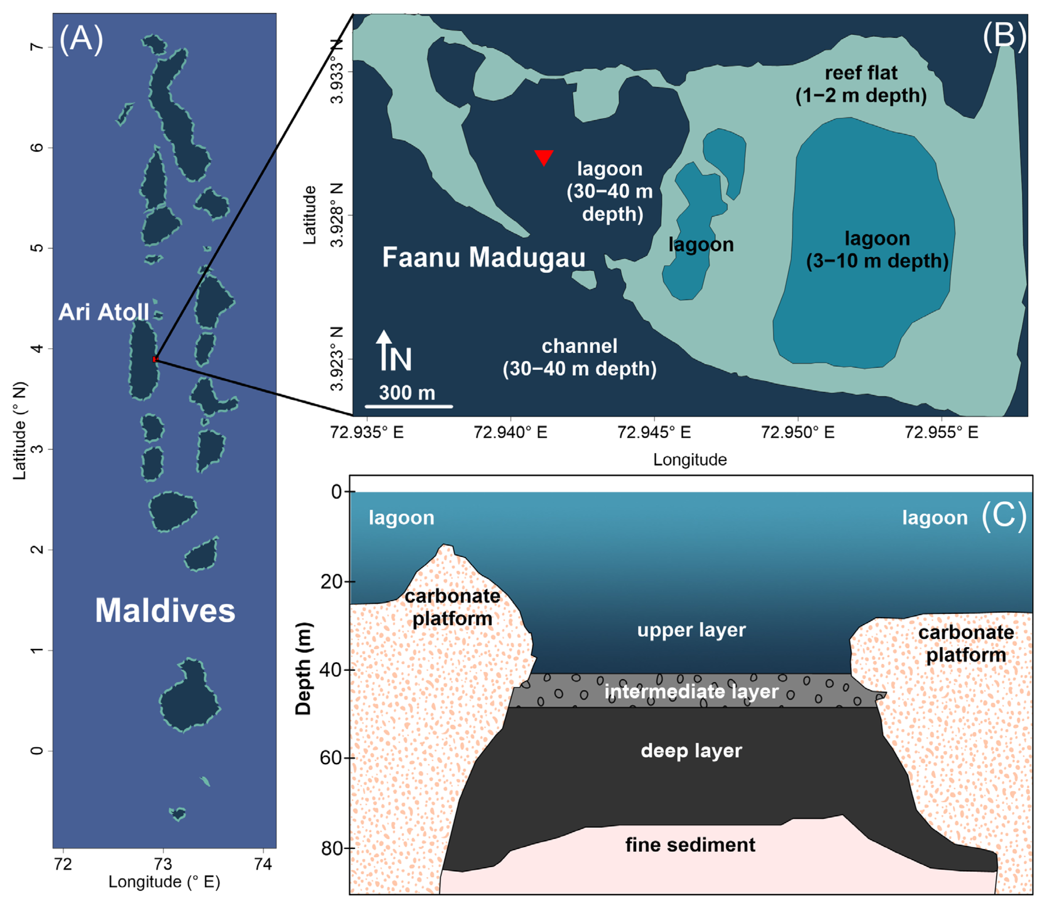
Abstract
:1. Introduction
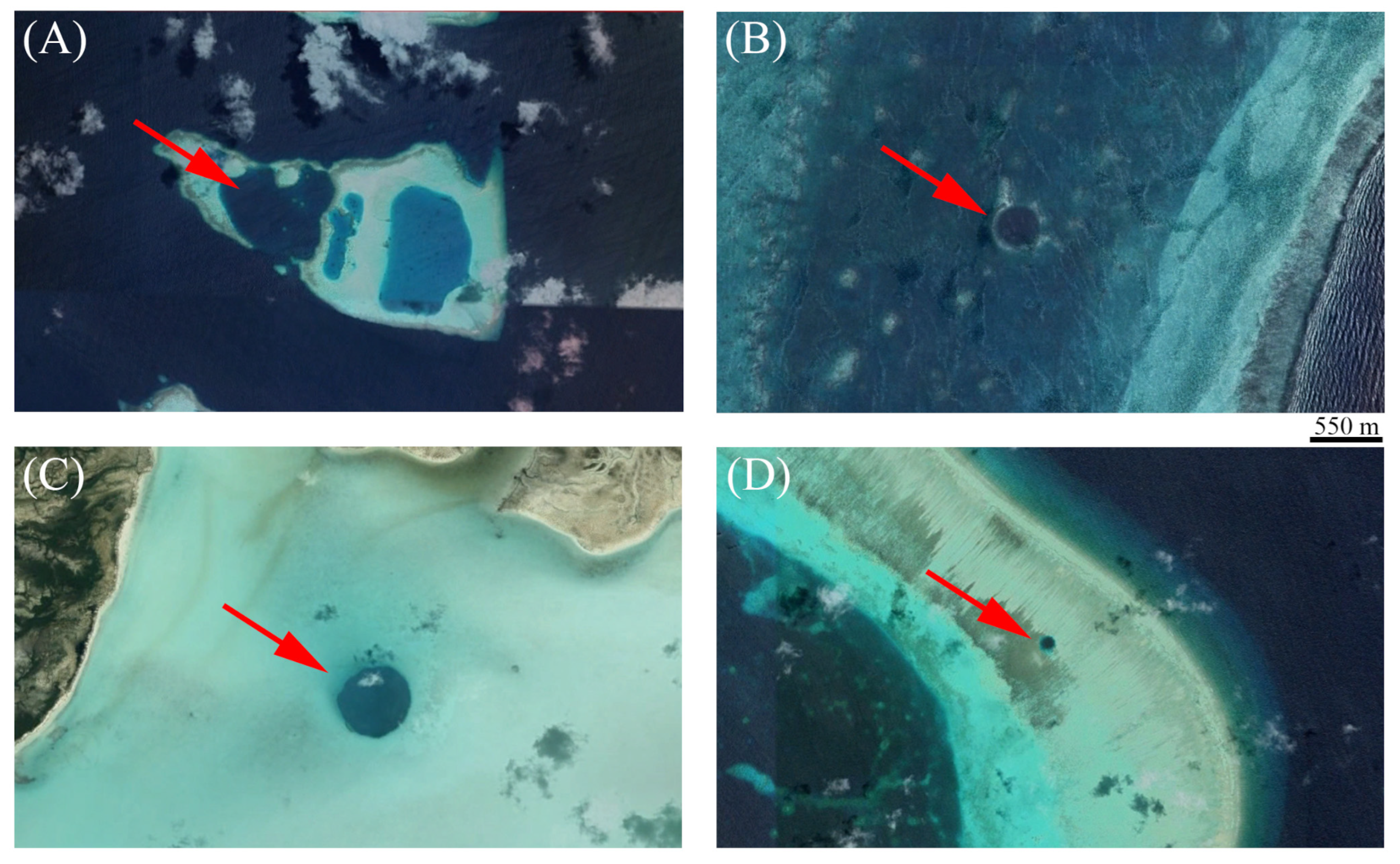
2. Study Area
3. Materials and Methods
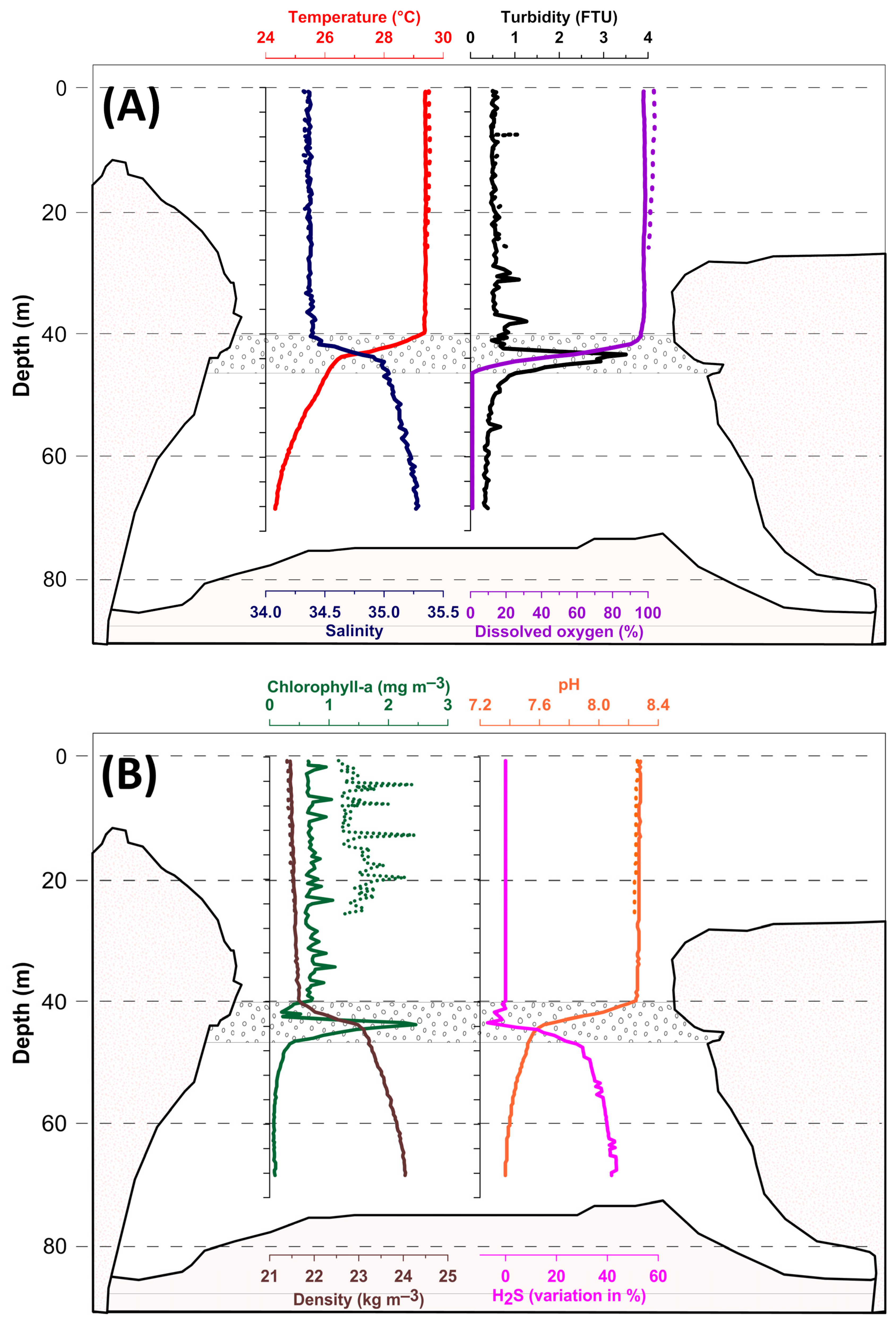
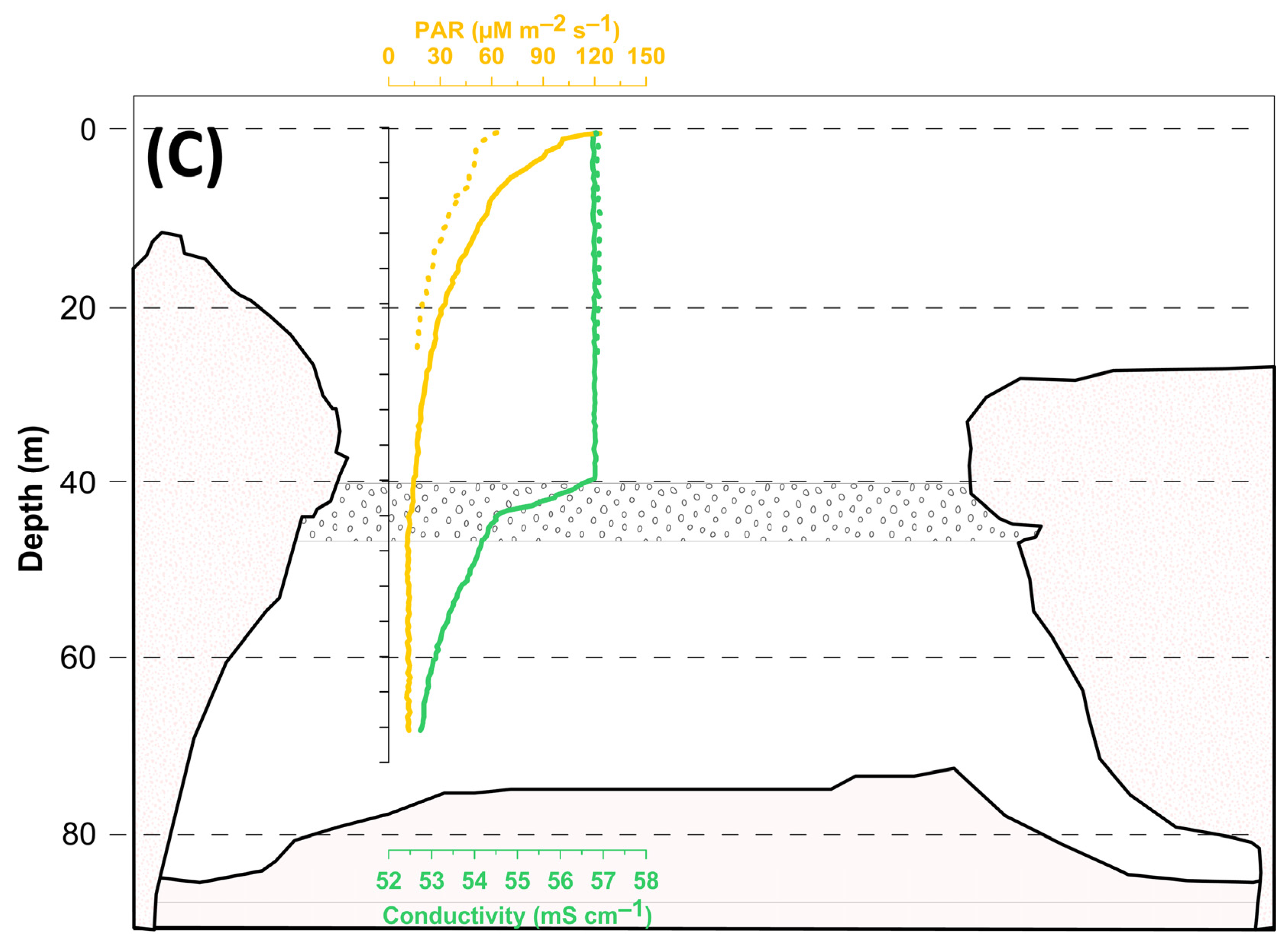
4. Results
5. Discussion
6. Conclusions
Author Contributions
Funding
Institutional Review Board Statement
Informed Consent Statement
Data Availability Statement
Acknowledgments
Conflicts of Interest
References
- Schwabe, S.; Carew, J.L. Blue Holes: An inappropriate moniker for scientific discussion of water-filled caves in the Bahamas. In Proceedings of the 12th Symposium on the Geology of the Bahamas and other Carbonate Regions, Gerace Research Center, San Salvador, Bahamas, 3–7 June 2006. [Google Scholar]
- Mylroie, J.E.; Carew, J.L.; Moore, A.I. Blue holes: Definition and genesis. Carbonates Evaporites 1995, 10, 225–233. [Google Scholar] [CrossRef]
- Mylroie, J.E.; Mylroie, J.R. Void development on carbonate coasts: Creation of anchialine habitats. Hydrobiologia 2011, 677, 15–32. [Google Scholar] [CrossRef]
- Yu, X.; Duan, B.C.; Guo, K.; Li, T.; Feng, A.; Du, J.; Villemant, B.; Ning, Y.; Liu, Y. Mapping and U–Th dating of the world’s deepest blue hole (South China Sea): Implications for its timing, possible volcanogenic origin, and Pleistocene eolianites in the Xisha Islands. Mar. Geol. 2022, 447, 106776. [Google Scholar] [CrossRef]
- Wyrwoll, K.H.; Zhong, R.Z.; Collins, L.B. Origin of blue hole structures in coral reefs: Houtman Abrolhos, Western Australia. J. Coast. Res. 2006, 22, 202–208. [Google Scholar] [CrossRef]
- Gischler, E. Blue Hole. Encyclopedia of Modern Coral Reefs. In Encyclopedia of Earth Sciences Series; Hopley, D., Ed.; Springer: Dordrecht, The Netherlands, 2011; pp. 164–165. [Google Scholar] [CrossRef]
- Canganella, F.; Bianconi, G.; Kato, C.; Gonzalez, J. Microbial ecology of submerged marine caves and holes characterized by high levels of hydrogen sulphide. Rev. Environ. Sci. Biotechnol. 2007, 6, 61–70. [Google Scholar] [CrossRef]
- Gischler, E.; Anselmetti, F.S.; Shinn, E.A. Seismic stratigraphy of the Blue Hole (Lighthouse Reef, Belize), a late Holocene climate and storm archive. Mar. Geol. 2013, 344, 155–162. [Google Scholar] [CrossRef]
- van Hengstum, P.J.; Winkler, T.S.; Tamalavage, A.E.; Sullivan, R.M.; Little, S.N.; MacDonald, D.; Donnelly, J.P.; Albury, N.A. Holocene sedimentation in a blue hole surrounded by carbonate tidal flats in The Bahamas: Autogenic versus allogenic processes. Mar. Geol. 2020, 419, 106051. [Google Scholar] [CrossRef]
- Wallace, E.; Donnelly, J.; van Hengstum, P.; Winkler, T.; Dizon, C.; LaBella, A.; Lopez, I.; d’Entremont, N.; Sullivan, R.; Woodruff, J.; et al. Regional shifts in paleohurricane activity over the last 1500 years derived from blue hole sediments offshore of Middle Caicos Island. Quat. Sci. Rev. 2021, 268, 107126. [Google Scholar] [CrossRef]
- Xie, L.; Wang, B.; Pu, X.; Xin, M.; He, P.; Li, C.; Wei, Q.; Zhang, X.; Li, T. Hydrochemical properties and chemocline of the Sansha Yongle Blue Hole in the South China Sea. Sci. Total Environ. 2019, 649, 1281–1292. [Google Scholar] [CrossRef] [PubMed]
- Gischler, E.; Shinn, E.A.; Oschmann, W.; Fiebig, J.; Buster, N.A. A 1500-year Holocene Caribbean climate archive from the Blue Hole, Lighthouse Reef, Belize. J. Coast. Res. 2008, 24, 1495–1505. [Google Scholar] [CrossRef]
- He, P.; Xie, L.; Zhang, X.; Li, J.; Lin, X.; Pu, X.; Yuan, C.; Tian, Z.; Li, J. Microbial diversity and metabolic potential in the stratified Sansha Yongle Blue Hole in the South China Sea. Sci. Rep. 2020, 10, 5949. [Google Scholar] [CrossRef]
- Iwanowicz, D.D.; Jonas, R.B.; Schill, W.B.; Marano-Briggs, K. Novel microbiome dominated by Arcobacter during anoxic excurrent flow from an ocean blue hole in Andros Island, The Bahamas. PLoS ONE 2021, 16, e0256305. [Google Scholar] [CrossRef]
- Kornicker, L.S.; Iliffe, T.M.; Harrison-Nelson, E. Ostracoda (Myodocopa) from Anchialine Caves and Ocean Blue Holes. Zootaxa 2007, 1565, 1–151. [Google Scholar] [CrossRef]
- Li, T.; Feng, A.; Liu, Y.; Li, Z.; Guo, K.; Jiang, W.; Du, J.; Tian, Z.; Xu, W.; Liu, Y.; et al. Three-dimensional (3D) morphology of Sansha Yongle Blue Hole in the South China Sea revealed by underwater remotely operated vehicle. Sci. Rep. 2018, 8, 17122. [Google Scholar] [CrossRef] [PubMed]
- Li, B.; Liu, J.; Zhou, S.; Fu, L.; Yao, P.; Chen, L.; Yang, Z.; Wang, X.; Zhang, X. Vertical variation in Vibrio community composition in Sansha Yongle Blue Hole and its ability to degrade macromolecules. Mar. Life Sci. Technol. 2020, 2, 60–72. [Google Scholar] [CrossRef]
- Liu, Y.; He, H.; Fu, L.; Liu, Q.; Yang, Z.; Zhen, Y. Environmental DNA sequencing reveals a highly complex Eukaryote community in Sansha Yongle Blue Hole, Xisha, South China Sea. Microorganisms 2019, 7, 624. [Google Scholar] [CrossRef]
- Martin, J.B.; Gulley, J.; Spellman, P. Tidal pumping of water between Bahamian blue holes, aquifers, and the ocean. J. Hydrol. 2012, 416–417, 28–38. [Google Scholar] [CrossRef]
- Ortiz, M.; Winfield, I.; Varela, C. First records of peracarid crustaceans from the Cayo Matias Ocean Blue Hole, SW Cuba, with the description of two new species. Zootaxa 2012, 3505, 53–66. [Google Scholar] [CrossRef]
- Schmitt, D.; Gischler, E.; Walkenfort, D. Holocene sediments of an inundated sinkhole: Facies analysis of the “Great Blue Hole”, Lighthouse Reef, Belize. Facies 2021, 67, 10. [Google Scholar] [CrossRef]
- Winkler, T.S.; van Hengstum, P.J.; Donnelly, J.P.; Wallace, E.J.; D’Entremont, N.; Hawkes, A.D.; Maio, C.V.; Sulliva, R.M.; Woodruff, J.D. Oceanic passage of hurricanes across Cay Sal Bank in The Bahamas over the last 530 years. Mar. Geol. 2022, 443, 106653. [Google Scholar] [CrossRef]
- Colantoni, P.; Baldelli, G.; Bianchi, C.N.; Capaccioni, B.; Morri, C.; Sandrini, M.; Tassi, F. A cave flooded by marine water with hydrogen sulphide highlights the recent evolution of the Maldives (Indianc Ocean): Preliminary notes. Grotte D’italia 2003, 4, 29–37. [Google Scholar]
- Lüdmann, T.; Betzler, C.; Lindhorst, S. The Maldives, a key location of carbonate drifts. Mar. Geol. 2022, 450, 106838. [Google Scholar] [CrossRef]
- Montefalcone, M.; Morri, C.; Bianchi, C.N. Influence of local pressures on Maldivian coral reef resilience following repeated bleaching events, and recovery perspectives. Front. Mar. Sci. 2020, 7, 587. [Google Scholar] [CrossRef]
- Dhunya, A.; Huang, Q.; Aslam, A. Coastal habitats of Maldives: Status, trends, threats, and potentianl conservation strategies. Int. J. Sci. Eng. Res. 2017, 8, 47–62. [Google Scholar]
- Stevens, G.M.W.; Froman, N. The Maldives Archipelago. In World Seas: An Environmental Evaluation, 2nd ed.; Sheppard, C., Ed.; Academic Press: Cambridge, MA, USA, 2019; Volume 2, pp. 211–236. [Google Scholar] [CrossRef]
- Alonso-Garcia, M.; Rodrigues, T.; Abrantes, F.; Padilha, M.; Alvarez-Zarikian, C.A.; Kunkelova, T.; Wright, J.D.; Betzler, C. Sea-surface temperature, productivity and hydrological changes in the Northern Indian Ocean (Maldives) during the interval ~575-175 ka (MIS 14 to 7). Palaeogeogr. Palaeoclimatol. Palaeoecol. 2019, 536, 109376. [Google Scholar] [CrossRef]
- Rasheed, S.; Warder, S.C.; Plancherel, Y.; Piggott, M.D. Response of tidal flow regime and sediment transport in North Malé Atoll, Maldives, to coastal modification and sea level rise. Ocean Sci. 2021, 17, 319–334. [Google Scholar] [CrossRef]
- Lüdmann, T.; Kalvelage, C.; Betzler, C.; Furstenau, J.; Hubscher, C. The Maldives, a giant isolated carbonate platform dominated by bottom currents. Mar. Pet. Geol. 2013, 43, 326–340. [Google Scholar] [CrossRef]
- Azzola, A.; Bianchi, C.N.; Bianconi, B.; Canganella, F.; Doni, L.; Montefalcone, M.; Morri, C.; Olivieri, C.; Peirano, A.; Taviani, E.; et al. Microbial ecology across an oxic-anoxic interface in a sulphidic Blue Hole. In Proceedings of the XXIII National Congress of Speleology, Ormea, Italy, 2–5 June 2022. [Google Scholar]
- Maldives Meteorological Service. Climate Report May 2022. Available online: https://www.meteorology.gov.mv/downloads (accessed on 11 September 2023).
- Rouf, M.A.; Islam, M.D.J.; Roknuzzaman, M.D.; Siddique, M.D.N.; Golder, M.D.R. Vertical profile of dissolved oxygen and associated water variables in the Pasur-Rupsha estuary of Bangladesh. Heliyon 2022, 8, e10935. [Google Scholar] [CrossRef]
- Schmitt, D.; Gischler, E.; Birgel, D.; Peckmann, J.; Anselmetti, F.S.; Vogel, H. Great Blue Hole (Lighthouse Reef, Belize): A continuous, annually resolved record of Common Era sea surface temperature, Atlantic Multidecadal Oscillation and cyclone-controlled run-off. Quat. Sci. Rev. 2020, 247, 106570. [Google Scholar] [CrossRef]
- He, H.; Fu, L.; Liu, Q.; Fu, L.; Bi, N.; Yang, Z.; Zhen, Y. Community Structure, Abundance and Potential Functions of Bacteria and Archaea in the Sansha Yongle Blue Hole, Xisha, South China Sea. Front. Microbiol. 2019, 10, 2404. [Google Scholar] [CrossRef]
- Qiao, F.; Huang, C.; Li, T.; Zhang, M.; Jiang, W.; Liu, Y. Mid-Holocene seawater preserved in the deepest oceanic blue hole. Sci. Bull. 2020, 65, 1975–1978. [Google Scholar] [CrossRef]
- Yao, P.; Wang, X.C.; Bianchi, T.S.; Yang, Z.S.; Fu, L.; Zhang, X.H.; Chen, L.; Zhao, B.; Morrison, E.S.; Shields, M.R.; et al. Carbon cycling in the world’s deepest blue hole. J. Geophys. Res. Biogeosci. 2020, 125, e2019JG005307. [Google Scholar] [CrossRef]
- Bjorneras, C.; Skerlep, M.; Gollnisch, R.; Herzog, S.D.; Ugge, G.E.; Hegg, A.; Hu, N.; Johansson, E.; Lee, M.; Pärssinen, V.; et al. Inland blue holes of The Bahamas—Chemistry and biology in a unique aquatic environment. Fundam. Appl. Limnol. 2020, 194, 95–106. [Google Scholar] [CrossRef]
- Chaudhuri, S.; Juan, P.; Serra, L. Analysis of precise climate pattern of Maldives. A Complex island structure. Reg. Stud. Mar. Sci. 2021, 44, 101789. [Google Scholar] [CrossRef]


Disclaimer/Publisher’s Note: The statements, opinions and data contained in all publications are solely those of the individual author(s) and contributor(s) and not of MDPI and/or the editor(s). MDPI and/or the editor(s) disclaim responsibility for any injury to people or property resulting from any ideas, methods, instructions or products referred to in the content. |
© 2023 by the authors. Licensee MDPI, Basel, Switzerland. This article is an open access article distributed under the terms and conditions of the Creative Commons Attribution (CC BY) license (https://creativecommons.org/licenses/by/4.0/).
Share and Cite
Cutroneo, L.; Ahmed, H.; Azzola, A.; Fontana, H.; Geneselli, I.; Mancini, I.; Montefalcone, M.; Oprandi, A.; Pancrazi, I.; Vanin, S.; et al. First Chemical–Physical Measurements by Multi-Parameter Probe in the Blue Hole of Faanu Madugau (Ari Atoll, the Maldives). Environments 2023, 10, 180. https://doi.org/10.3390/environments10100180
Cutroneo L, Ahmed H, Azzola A, Fontana H, Geneselli I, Mancini I, Montefalcone M, Oprandi A, Pancrazi I, Vanin S, et al. First Chemical–Physical Measurements by Multi-Parameter Probe in the Blue Hole of Faanu Madugau (Ari Atoll, the Maldives). Environments. 2023; 10(10):180. https://doi.org/10.3390/environments10100180
Chicago/Turabian StyleCutroneo, Laura, Hassan Ahmed, Annalisa Azzola, Herbert Fontana, Irene Geneselli, Ilaria Mancini, Monica Montefalcone, Alice Oprandi, Irene Pancrazi, Stefano Vanin, and et al. 2023. "First Chemical–Physical Measurements by Multi-Parameter Probe in the Blue Hole of Faanu Madugau (Ari Atoll, the Maldives)" Environments 10, no. 10: 180. https://doi.org/10.3390/environments10100180
APA StyleCutroneo, L., Ahmed, H., Azzola, A., Fontana, H., Geneselli, I., Mancini, I., Montefalcone, M., Oprandi, A., Pancrazi, I., Vanin, S., & Capello, M. (2023). First Chemical–Physical Measurements by Multi-Parameter Probe in the Blue Hole of Faanu Madugau (Ari Atoll, the Maldives). Environments, 10(10), 180. https://doi.org/10.3390/environments10100180