Article

Wildfire Impacts on Slope Stability Triggering in Mountain Areas

Department of Civil and Environmental Engineering, Politecnico di Milano, 20133 Milano, Italy
*
Author to whom correspondence should be addressed.
Geosciences 2019, 9(10), 417; https://doi.org/10.3390/geosciences9100417
Submission received: 31 July 2019 / Revised: 20 September 2019 / Accepted: 23 September 2019 / Published: 25 September 2019

Abstract

:
Landslides over steep slopes, floods along rivers plains and debris flows across valleys are hydrogeological phenomena typical for mountain regions. Such events are generally triggered by rainfall, which can have large variability in terms of both its intensity and volume. Furthermore, terrain predisposition and the presence of some disturbances, such as wildfires, can have an adverse effect on the potential risk. Modelling the complex interaction between these components is not a simple task and cannot always be carried out using instability thresholds that only take into account the characteristics of the rainfall events. In some particular cases, external factors can modify the existing delicate equilibrium on the basis of which stability thresholds are defined. In particular, events such as wildfires can cause the removal of vegetation coverage and the modification of the soil terrain properties. Therefore, wildfires can effectively reduce the infiltration capacity of the terrain and modify evapotranspiration. As a result, key factors for slope stability, such as the trend of the degree of saturation of the terrain, can be strongly modified. Thus, studying the role of wildfire effects on the terrain’s hydrological balance is fundamental to establish the critical conditions that can trigger potential slope failures (i.e., shallow landslides and possible subsequent debris flows). In this work, we investigate the consequences of wildfire on the stability of slopes through a hydrological model that takes into account the wildfire effects and compare the results to the current stability thresholds. Two case studies in the Ardenno (IT) and Ronco sopra Ascona (CH) municipalities were chosen for model testing. The aim of this paper is to propose a quantitative analysis of the two cases studies, taking into account the role of fire in the slope stability assessment. The results indicate how the post-fire circumstances strongly modify the ability of the terrain to absorb rainfall water. This effect results in a persistently drier terrain until a corner point is reached, after which the stability of the slope could be undermined by a rainfall event of negligible intensity.

1. Introduction

Landslides, floods and debris flows represent serious hydrogeological hazards in mountain environments [1,2,3,4]. In particular, debris flows are often the result of soil erosion and sediment transport and can build up over long timescales due to the intermittency of mass wasting processes controlled by triggering events of varying intensity and duration [5]. These are complex and heterogeneous phenomena, so a great deal of effort has been made in the past to try and interpret their dynamics and triggering factors. There are many studies concerning shallow landslide dynamics in the literature [6,7,8,9] based both on laboratory and field experiments, which individuate rainfall as the main triggering factor for this type of phenomenon [10,11,12].
The major outcome of these studies is the definition of intensity-duration rainfall thresholds and the estimation of the susceptibility of a slope to slip and possibly evolve into a debris flow [13,14,15]. The characteristics of precipitation, that is, its intensity and duration, are used as indicators of the probability of the failure of a slope. A rainfall event can be characterized by evaluating its return period [1,16] using the Curves of Pluviometric Possibility [16] which can assess whether a meteorological event magnitude is exceptional or not [1,17].
This approach has been widely adopted in the scientific community and appears to be effective for a variety of cases in which instability conditions are established by considering precipitation characteristics only. Nevertheless, the rainfall thresholds are not always representative for a hazard estimation, since they do not consider other possible external perturbations for landslide triggering, which could increase the probability of slope failure.
In general, an intense rainfall event represents a necessary condition for slope failure [18]. In fact, variations in the terrain’s initial conditions, such as the antecedent soil moisture, can strongly modify the slope’s response at the local scale [6,8,19]. This is particularly true if the terrain surface is deteriorated after a severe wildfire [11,20,21,22,23]. In a post-fire situation, the soil conditions are strongly modified as schematically presented in Figure 1a,b. The removed vegetation can alter the normal hydrogeological cycle of the terrain by changing the evapotranspiration and infiltration rates, which are consistently reduced [11,22,24]. The decreasing evapotranspiration can increase the average humidity inside the terrain [9]. On the other hand, the decrease of infiltration capacity is caused by the formation of a hydrophobic layer on the surface (Figure 1b). The change of soil properties is due to the presence of high temperature and the occlusion of the soil’s macro-pores by the ash generated by burned forest litter [18]. The main consequence of this is an increase in the total runoff discharge [11,12] and sediment erosion in correspondence to the watershed channels [20,25,26,27]. This is particularly evident in some degraded soil where the vegetation is not able to recover in short periods.
In semi-arid and arid climates [29], wildfires are very frequent, particularly during the summer season where high temperatures and low precipitation affect shrubs and forests [22]. Several studies have been carried out in the U.S. [11,20,21,24], where back analyses of real events and field controlled experiments have been carried out. In the Mediterranean area, which is a wildfire-prone area, some studies have been carried out in Spain and Portugal [23]. In Italy, qualitative back analysis of the wildfire effects are reported [2,12] but very few cases provide a quantitative interpretation of that phenomenon by considering its hydrogeological implications on the territory [22]. Certainly, there is a lack of exhaustive research on the effects of wildfire as they relate to the susceptibility of the terrain to land sliding.
After wildfires, a large number of the burned areas experience some hydrogeological issues, such as soil slip formation, in response to rainfall events [11,20,21]. This relationship of cause (wildfire) to effect (terrain instability) is reported to still have some poorly understood aspects [18]. In these cases, the rainfall thresholds are not sufficient for the estimation of slope failure susceptibility, as wildfires’ collateral effects may have a stronger influence.
The goal of this work is to explore the complex interaction between precipitation and soil, considering the effects of wildfire perturbations and to quantitatively evaluate those effects on post-fire slope stability. We demonstrate the inability of the current rainfall thresholds to grasp the complexity of the problem and to effectively indicate the occurrence of slope failure. We thus propose a simple hydrological balance model that implements the effects of wildfire on water infiltration and, therefore, takes into account the different process dynamics generated by the occurrence of wildfire. Two case studies of Ardenno and Ronco sopra Ascona have been considered to test the model results and demonstrate that the proposed method is a valid approach for soil stability evaluation under exceptional circumstances, such as after wildfires.
This paper is organized as follows. In Section 2.1, we present the model adopted to analyse the wildfire effects on hydrologic terrain cycle over an idealized portion of slope soil along with a description of the two case studies. In Section 2.2, the simulation results obtained through the application of the model within the two burned areas in Ardenno and Ronco sopra Ascona are reported. Finally, in Section 3, we propose a discussion of the results, followed by the conclusion of the manuscript in Section 4.

2. Materials and Methods

Starting from the theory of the terrain water balance described in Reference [9], in the following paragraphs, we present the characteristics of the model we adopted to interpret the effects of wildfire on terrain hydrological water balance.

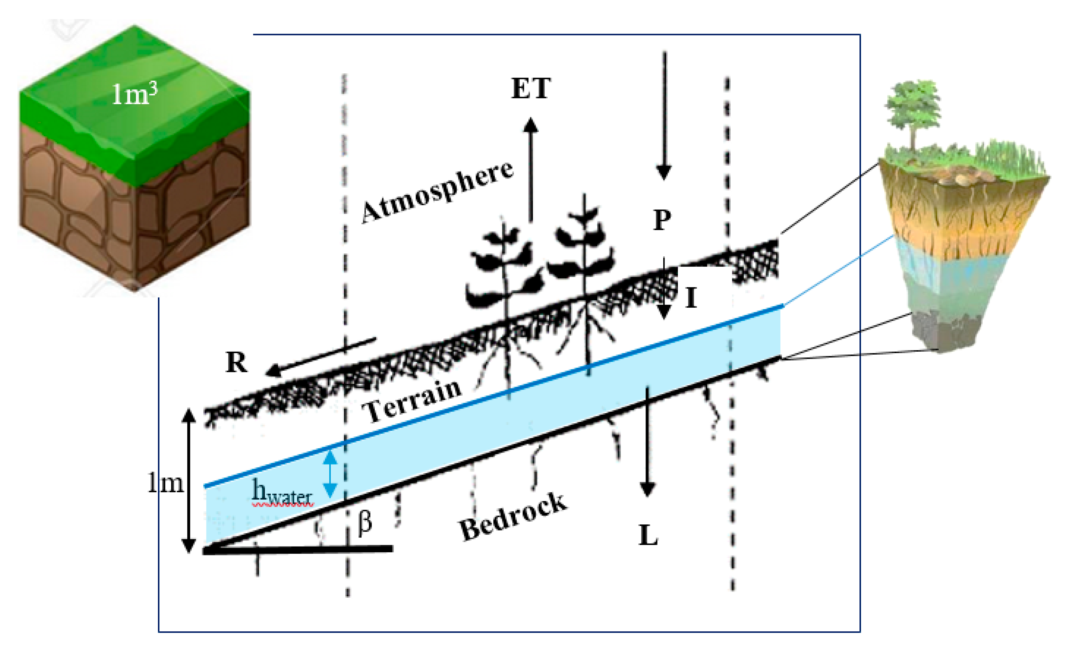
2.1. The Terrain Water-Balance Model

The model proposed and schematically illustrated in Figure 2 evaluates the terrain’s water balance through an estimation of the water mass fluxes, which can change the soil’s water content. We consider 1 m3 of terrain, which, according to field data reported in References [2,12], can approximate quite well the soil slope conditions inside the catchments of the Ardenno and Ronco sopra Ascona. Indeed, a 1 m depth is representative of the terrain depth that will later be subject to model application [2,12].
The complete terrain water-balance equation [9] is described in Equation (1):
Δ h w a t e r ( t ) Δ t   =   P ( t )     I ( t )     E T ( t )     L ( t )     R ( t )
where the first term expresses the daily temporal variation (Δt is equal to 1 day) of soil water content hwater [mm], P(t) [mm/day] are the rainfall data series, I(t) is the infiltration term [mm/day], ET(t) is the evapotranspiration [mm/day], L(t) is the groundwater losses [mm/day] and R(t) is the surface runoff [mm/day]. This model could be applied considering other temporal time resolutions (i.e., hourly). However, this depends on the characteristics of the input data, in particular, the meteorological parameters, such as temperature, precipitation and solar radiation. Only in recent years have hourly or sub-hourly data been available, yet historical data series are mainly daily. Therefore, the model has been adapted to the temporal resolution of the data available for the locations of Ardenno and Ronco sopra Ascona.
The rainfall, P, is represented by the daily time series recorded by the rain gauge, located closest to the considered area.
P = P ( t )
where t = 1 day.
Concerning the evapotranspiration, ET, we consider the Hargraves formula [30] for potential evapotranspiration, which is then corrected with a factor, Kc, to obtain the effective evapotranspiration. The Hargreaves’ formula requires the maximum (Tmax), the minimum (Tmin) and the average (Tmean) daily temperature, as well as the global radiation (Ra) recorded at the weather station:
E T 0 ( t )   =   0.023   × 0.408 ( T m e a n ( t )   +   17.8 ) ( T m a x ( t )     T m i n ( t ) ) 0.5 R a ( t )
E T ( t )   =   K c E T 0 ( t )
Looking at the losses, L, the model estimates the filtration flux via the Darcy equation. An approximation of the hydraulic gradient with the slope angle is adopted, assuming the water table to be parallel to the slope.
L ( t )   =   A ( t ) K s a t Δ h w a t e r ( t ) Δ L g r o u n d     A ( t ) K s a t sin ( β )    
where A = 1   m 2 S r ( t ) and β [°] slope angle.
Considering the soil composition, the block of terrain can be characterized by porosity, ϕ, an effective porosity, ϕe and saturation permeability. The latter can be evaluated indirectly using the Koseny–Carman equation [31,32] and the granulometric curve of the soil [32,33]:
K s a t   =   C k g v ϕ 3 ( 1     ϕ ) 2 d 10
Under the hypothesis that voids can be completely filled by water, the effective porosity represents the maximum volume of water that can be stored inside the terrain block. The minimum value of the degree of saturation is defined by the wilting point that represents a minimum amount of water in the soil that the plant requires not to wilt [9]:
S r ( t )   =     V w a t e r ( t ) V v o i d s   =   h w a t e r ( t ) A ϕ   h t e r r a i n   A   =   h w a t e r ( t ) ϕ   h t e r r a i n .
The runoff, R, is regulated by two different processes: the infiltration and the exfiltration [9]. If the rainfall rate is higher than the infiltration capacity (I) of the soil, the part of the water that did not infiltrate can flow overland and generate runoff. On the contrary, if the soil is completely saturated, the water cannot directly infiltrate, so it exfiltrates, thereby generating (also in this case) runoff:
I ( t ) = α P ( t )
R ( t ) = P ( t ) I ( t )                   i f   P > I R ( t ) = 0                                     i f   P < I R ( t ) = P ( t )                       i f   s a t u r a t e d
where α is infiltration coefficient.
This model was implemented by integrating Equation (1) on a daily basis using the Forward Eulero numerical scheme [9]. The water content at time ti is evaluated as a function of the quantities calculated at the previous time step, ti−1. This scheme is generally suitable for the integration of the balance equations thanks to its relative numerical stability and its simplicity for direct implementation. Therefore, its good approximation of the real solution is precise enough for correct evaluation of the water balance on a daily basis, which is necessary to estimate the terrain’s degree of saturation (Sr):
h w a t e r ( t i )   =   h w a t e r ( t i 1 ) Δ t   +   P ( t i 1 )       I ( t i 1 )     E T ( t i 1 )     L ( t i 1 )     R ( t i 1 )
S r ( t i ) [ % ] = h w a t e r ( t i ) ϕ   h t e r r a i n

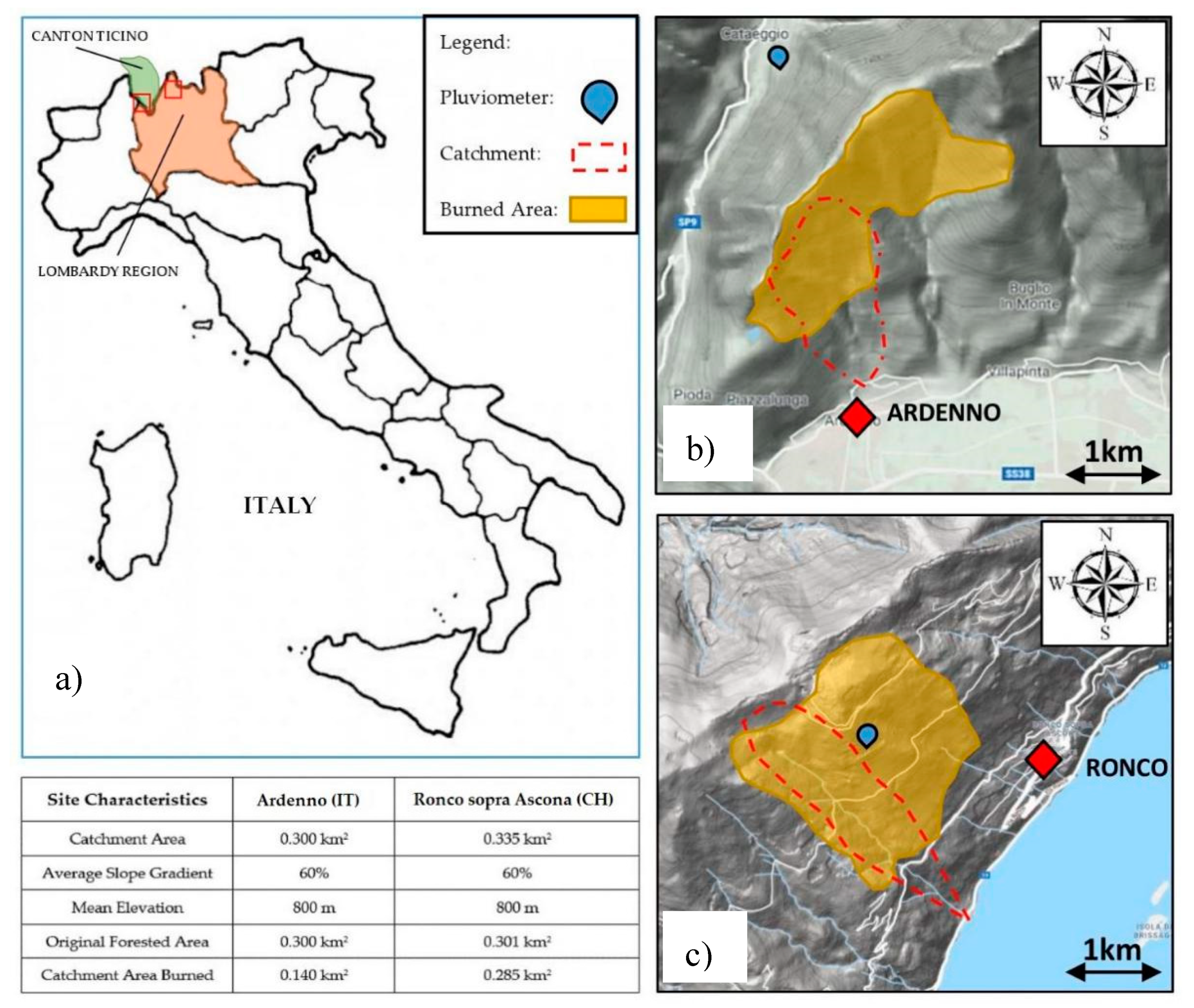
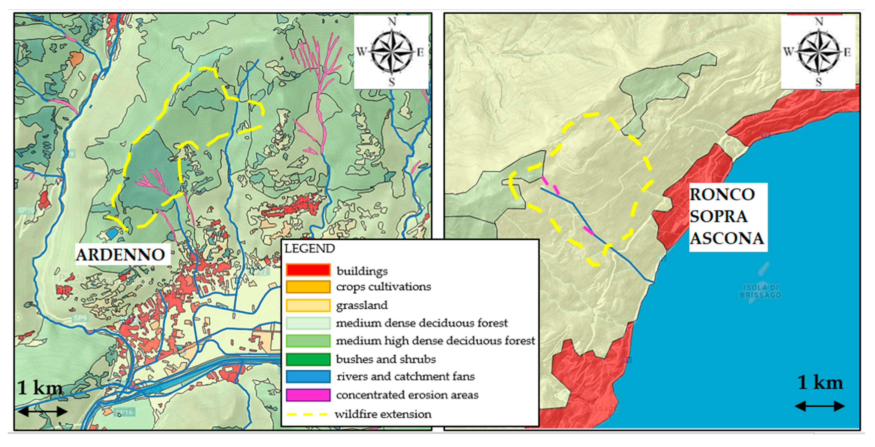
2.2. Ardenno (IT) and Ronco Sopra Ascona (CH) Case Studies

Two cases of debris flow generated from terrain slope failure after severe wildfires were analysed and proposed for validation of the applied method. Our attention was mainly focused on the triggering factors and the antecedent conditions that led to slope destabilization, rather than a reconstruction of the precise event dynamics (i.e., debris flow discharge).
The Ardenno area was affected by a severe wildfire during March 1998, and, starting from 26 June 1998, the town of Ardenno experienced a series of three dangerous debris flow events. A similar event struck the town of Ronco sopra Ascona (Canton Ticino, Switzerland) on 28 August 1997 [12] after a wildfire occurred in March 1997 in that area. These wildfires occurred during dry warm Foehn windy conditions during the winter season and spread across the two catchments in the upper part of the two towns of Ardenno and Ronco, as reported in Figure 3. These areas, both at an average elevation of 800 m, were predominantly covered by deciduous forests that were severely damaged by the fire.
Two debris flow events occurred within the affected catchments in response to slightly intense rainfall events. For Ardenno, the first debris flow event occurred during a typical thunderstorm, characterized by an intensity of 12–13 mm in 30 min. This was recorded by the rain gauge, nearest to the Ardenno catchment (Figure 3). This intensity corresponded to an event with a return time of 1.5 years.
For Ronco sopra Ascona, the soil slip event occurred during a heavy thunderstorm with an intensity of 80 mm in 4 h. This was recorded by the nearest rain gauge, which, in that case, was settled in the catchment above the town of Ronco sopra Ascona (Figure 3). The precipitation event’s return period was calculated to be around 10 years. Even though the rainfall intensities were not extreme, their impacts on the Ardenno and Ronco sopra Ascona towns have been particularly severe and led to extended damage. The volume of the sediment that reached the towns was estimated to be around 15,000 m3 for Ardenno and 5000 m3 for Ronco sopra Ascona. The causes of the debris flows recorded in the study sites are likely the result of the complex interactions between rainfall events and local slope instabilities that occurred after the wildfire alteration of the surface layer in the upper part of the catchments. Using the model described in the previous paragraph, we attempted to investigate these aspects in a more quantitative way.

2.3. Model Settings

A detailed characterization of the geomorphology and geology of the two sites was carried out in order to estimate the parameters required for model simulation. The Ardenno and Ronco sopra Ascona catchments have similar morphologies, with extensions of 0.3 km2 and average slope gradients of 60%. From a geological point of view, these two sites are located relative to the alpine Insubric line, a tectonic fault oriented west–east. The rock outcrops are prevalently formed by metamorphic material, such as gneiss, in the Ardenno area and by diorites in Ronco sopra Ascona. The slopes are covered by a thin layer of superficial soil derived from the degradation of rocks and alluvial deposits, with an average depth of 1–2 m. The slope bedrocks are characterized by different grades of degradation depending on the specific location but their permeability is much lower than the permeability of the soil layer. The latter has been evaluated via the SoilGrids database [34,35], which allowed for the classification of the slope terrains in both locations as sandy loam—a somewhat permeable soil. Its permeability in saturated conditions was estimated to be in the order of 10−5 m/s. The slope’s vegetation coverage before the wildfire events was characterized by the presence of a medium to high density deciduous forest, with the presence of medium-sized trees. The susceptibility of the territories of Ardenno and Ronco sopra Ascona to landslide phenomena was identified by a hydrogeological assessment plans of the local municipalities. As can be observed in Figure 4, both sites are prone to hydrogeological destabilization in the upper part of the catchments.
Considering the previous information of the two catchments, a model calibration was necessary to test its ability to correctly reproduce the values of terrain saturation in the burned catchments of Ardenno and Ronco sopra Ascona.
Particular attention was devoted to the assessment of the soil’s degree of saturation relative to the wildfire event. Consequently, we considered the temporal window of one year before the wildfire event (Table 1) and ran the model several times, varying the initial soil saturation at t = 0. Indeed, due to the absence of field measurements for the soil moisture in pre-fire conditions, we lacked the data necessary for starting post-fire [36] model simulations. At the end of the calibration, we observed that the effects of the initial conditions on water balance were negligible after a few months of running the model due to the redistribution of hydrological fluxes.
In normal conditions, antecedent to wildfire events, the effective evapotranspiration can be calculated as a product of the potential evapotranspiration (obtained from Hargreaves) and the crop seasonal factor, Kc, which takes into account the presence of vegetation coverage. According to FAO (Food Agriculture Organization) indications [37], this seasonal change settled to 0.5 in winter (December, January, February and March), 0.8 during spring (April and May) and autumn (October and November), 1 during the summer (June, July, August and September).
Regarding the infiltration, we have chosen a simple percentage method where parameter α represents the portion of rainfall infiltrated into the soil. For the type of the soil that characterizes the two catchments, that is sandy loam, the minimum infiltration rate fc in conditions of full saturation is around 15 mm/h, according to the theory of Horton [9]. In conditions of partial saturation, this value could be higher, so the overall efficiency of the infiltration process is rather elevated for this type of terrain. In particular, the terrain can absorb almost all the precipitation reaching the surface and the runoff can occur only via exfiltration when it is completely saturated. Following this assumption, we have set parameter α = 1 for the calibration periods antecedent to the wildfires, when the surface area was in an optimal condition. This represents an upper bound, describing the worst condition for the slope stability assessment, assuming that vegetation rainfall interception is neglected. These approximations are believed to be suitable for a daily application of water balance, since a more detailed infiltration model could not be implemented due to the lack of precipitation data with a higher temporal resolution within the two catchments.
Table 1 summarizes the data used for both sites for the soil properties gathered from the Soil Grids database [34,35], the weather stations from [17] and the model’s calibration settings.
After the calibration of the model, post-fire settings were defined for both locations, as reported in Table 1. In particular, evapotranspiration and infiltration fluxes were modified to take into account the wildfire disturbance on the water terrain balance.
According to field experiments reported in Reference [28], the evapotranspiration term was reduced permanently after the wildfire, introducing a constant Kc of 0.3. This parameter can reportedly simulate the condition of poor vegetated soil, which is typical of the early stages of vegetal development, as indicated in Reference [37]. As a first approximation, it can be associated with a charred bare soil surface where vegetation has not yet recovered. This value was maintained constant for the entire post-fire simulation.
The infiltration factor, α, was reduced from 1 to 0.3, in order to represent the inhibition of infiltration caused by the formation of a hydro-repellent layer of soil and the pore obstruction by ash present on the surface [18]. This reduction is consistent with some field experiments carried out within the Rocky Mountain forests in the U.S. in Reference [11], where a correlation was found between the runoff increment and the relative infiltration reduction in wildfire-affected catchments. Indeed, in the periods after a wildfire, the runoff is estimated to increase around three times, while the infiltration is reduced to 1/3 based on a simple hydrological balance. A partial confirmation of these results was established in Reference [12] for the event that occurred in Ronco sopra Ascona, where an increase in runoff by a factor of 2.8 was directly evaluated inside the catchment affected by the wildfire event.
It was assumed that events with a 1 to 2 year return period occurred after wildfires could have progressively washed out the hydrophobic layer and have partially recovered the previous soil infiltration capacity, as argued in References [11,18], which report a qualitative interpretation of this phenomena. Thus, the infiltration parameter, α, was progressively increased by 0.1 after every rainfall event with more than 50 mm of rain recorded by local rain gauges. Considering the field experiments carried out in Reference [24], where the infiltration capacity of the soil was observed to have recovered during rainfall events, it was established that the hydrophobic layer degraded progressively. Different values for this recovery rate were tested and it was concluded that a 0.1 increment factor yields the best results for the two sites. Following this approach, the maximum infiltration rate attained some months after the fire was around 0.6, which is compatible with the infiltration conditions of a charred area evaluated within the first year after a wildfire, as studied in References [11,24].

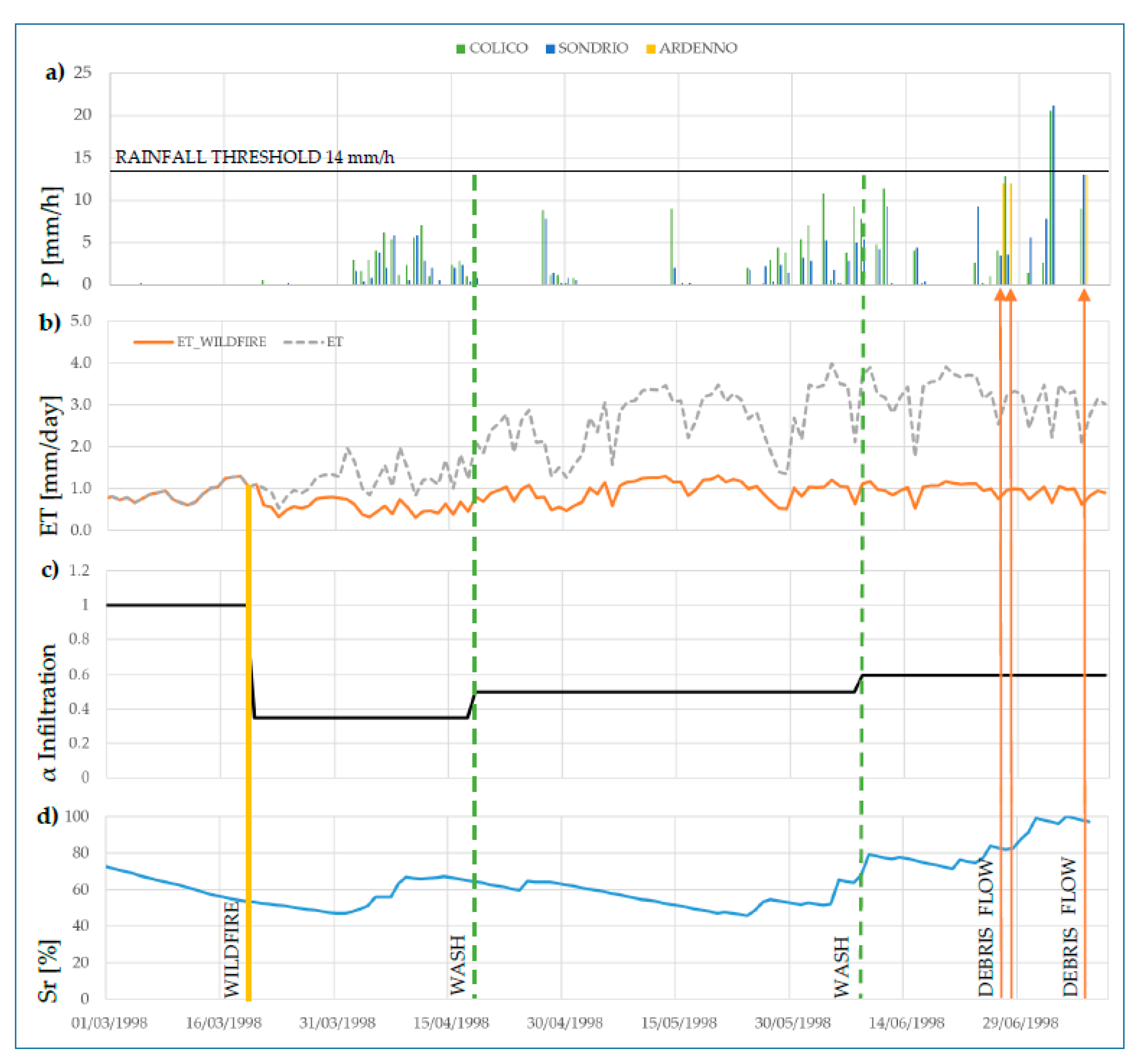
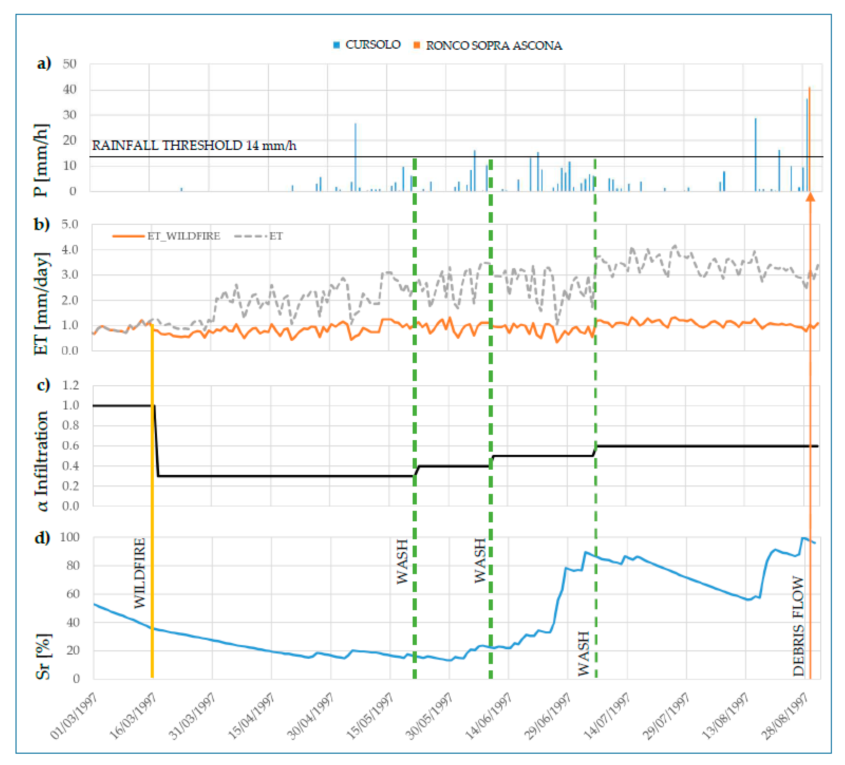
3. Results and Discussion

In this section, all the results we obtained from the two simulations of the Ardenno and Ronco sopra Ascona case studies are reported.
From the precipitation analysis, we can deduce that triggering events are characterized by a return period on the order of 1 up to 10 years for both locations. These events correspond to typical summer thunderstorm events, which can occur in the Alpine region and are often associated with slightly intense rainfall rates. On the contrary, the debris flows that affected the Ardenno and Ronco sopra Ascona towns were reported to be severe and rare hydrogeological events. In particular, for Ardenno, the last comparable debris flow event was recorded in 1949 [2] and the last Ronco sopra Ascona event was associated with a flood wave that has a return period of at least 100 years [12].
From the analysis of the rainfall return periods, it seems quite clear that rainfall triggering event intensities poorly explain the severity of the analysed hydrogeological episodes. In addition, the examination of the rainfall threshold curves [14] provides further confirmation of the relatively low intensity of the precipitation events, with both events below the triggering threshold. Debris flows are not necessarily linked to the return period of rainfall events, in which other morphological data, such as the sediment availability and production in the catchment, can influence the triggering. However, trying to reconstruct the historical evolution of the terrain behaviour in post-wildfire conditions is undoubtedly a key strategy for better interpretation of the causes of slope destabilization that occurred at the studied sites.
Figure 5a shows that in response to the three debris flow events that happened subsequently on 26 and 27 June and 7 July 1998 in Ardenno, the recorded rainfall intensities were slightly lower than the threshold proposed in Reference [14], which has been specifically evaluated for that area. Furthermore, during the rainfall on 3 July 1998, the threshold was overcome but no debris flows were triggered in the area. These considerations have been made, observing hourly rainfall intensities recorded in the Sondrio and Colico rain gauges, located in the surrounding area (15 km) of Ardenno city and merged with the daily rainfall data gathered from the Ardenno rain gauge.
Figure 5b–d presents the model results for evapotranspiration, the infiltration coefficient and the degree of saturation of the terrain, considering the simulation period comprising the wildfire and debris flow events. On 20 March 1998, a wildfire affected the catchment area above Ardenno, destroying a large portion of the pre-existing forest. Subsequently, the effective evapotranspiration was significantly reduced with respect to normal conditions due to the vegetation removal, as illustrated in Figure 5b. A hydrophobic layer formed on the terrain’s surface causing a significant reduction in infiltration capacity, represented by the decrease of coefficient α (Figure 5c). Afterwards, a period of relatively low precipitation and the wildfire alteration of hydrological fluxes contributed to the progressive decrease of the degree of saturation, Sr. The infiltration coefficient, α, was slightly increased after only two significant rainfall events were recorded during the spring. In these cases, the hydrophobic layer and hydro repellent litter on the surface were supposed to have been progressively washed out by rain, thereby allowing the recovery of infiltration capacity. As a result, the degree of saturation began again to increase constantly until the end of June 1998. Figure 5d shows that the saturation of the terrain approached its highest values in response to the occurrence of debris flow events.
Looking at Figure 6a for Ronco sopra Ascona, the rainfall threshold has been reached several times if we consider the period between the wildfire and debris flow events. In this case, the threshold has overestimated the probability of failure, resulting in false positive alarms before the effective triggering event, which occurred on 28 August 1998. This calculation was done based on the hourly rainfall intensities recorded in the rain gauge of Cursolo, which is 10 km away from Ronco sopra Ascona, merged with data from the rain gauge data from Locarno.
In Figure 6b–d, we can observe the trends for the model results of Ronco sopra Ascona, which are very similar to those of Ardenno. A period of relatively dry weather affected the region during the winter and early spring, until the end of April 1997. These effects can be clearly distinguished in Figure 6d, where the model shows an exponential decrease in water content in the absence of rainfalls. Meanwhile, on 15 March 1997, the wildfire affected the territory of Ronco sopra Ascona. In this case, the evapotranspiration (Figure 6b) and infiltration (Figure 6c) coefficients were also highly altered by the impact of wildfire on the terrain’s surface. The dry period ended around the middle of May. Afterwards, the area was affected by several rainfall events, one of which was the intense rainfall of June 1997 [38]. No debris flows were recorded in this area, even though the total amount of rain was calculated to be around 200 mm in only one week. This is most likely due to the combination of the previously very dry conditions of the soil and the alteration of the hydrologic balance of the surface due to wildfire, which significantly decreased its infiltration capacity. The model in Figure 6d indicates how water content increased up to a value below the complete saturation threshold. Then, a dry month followed, which contributed to a decrease in the terrain’s saturation until the end of August, where an abrupt increase of Sr was simulated by the model in response to the triggering event of 28 August 1998.

Discussion

Looking at the two case studies, the results show that it is not possible to identify a clear cause–effect relationship between the intensity of the triggering rainfall event and the magnitude of the hydrogeological event. Additional aspects, such as the condition of the terrain’s surface, should be considered for better comprehension of the dynamics of the phenomena under investigation. Indeed, looking only at the rainfall threshold curves, for the case of Ardenno, there is an underestimation of the probability of slope failure, while for Ronco sopra Ascona, some false alarms are reported before the critical event. The rainfall thresholds can reveal some information on potential critical rainfall events, but, in this case, the role of wildfire seems to be determinant in provoking progressive slope destabilization, which later caused the debris flow events. Therefore, a more complete analysis has been carried out, considering the effects of wildfires on the evolution of the local terrain’s degree of saturation, which is one of the key parameters for slope stability assessment.
In the case studies presented here, the corrections of the infiltration and evapotranspiration terms have led to better simulations of the water balance evolution, in order to take into account the post-fire effects. The alteration of hydrological fluxes on surfaces due to wildfire, that is, vegetation removal and hydrophobic layer formation, have played an important role in the temporal evolution of the terrain’s saturation. Thus, post-fire rainfall events have been considered to be determinant for the removal of the hydrophobic layer over the terrain’s surface, as discussed in Reference [18]. Looking at shorter temporal scales, the hydrophobic layer’s regression seems to be fundamental for the modification of the terrain’s infiltration rate. In both cases, lower infiltration rates have delayed the progressive saturation of the terrain, in response to significative rainfall events. On the other hand, evapotranspiration recovery cannot be experienced immediately unless we analyse its evolution for a longer period, for example, 4–5 years [28].
Another important consideration is related to the initial conditions of the soil moisture relative to the wildfire. These conditions represent the main source of uncertainty associated with our hydrological model, as they are not directly measured in situ but are instead estimated through a calibration procedure. Indeed, they are crucial parameters that can have a strong influence on the final model data results. Therefore, model calibration was necessary to establish the most likely initial soil moisture conditions, which were Sr = 50% for Ardenno and Sr = 30% for Ronco sopra Ascona in response to the wildfire events, respectively. These results represent an approximation of the real values but are indicative of a more humid initial condition for Ardenno. This situation has probably contributed to the higher values of Sr for the Ardenno area, which experienced debris flow events two months earlier rather than Ronco sopra Ascona.
In both cases, the model results clearly show the fluctuation of the Sr parameter, which depends mainly on hydrological fluxes and is sensitive to the initial conditions of the terrain. This model coherently demonstrates that the values of Sr approach the saturation level in response to debris flow events in both cases (Figure 5d and Figure 6d), reaching critical values between 80% and 100%. It is remarkable that our estimation is in accordance with the literature, as reported in Reference [6], where debris flow or soil slip triggering occurs, more generally, with a higher terrain degree of saturation. In the present case, we obtained this result via a hydrological model, even though prior studies are mainly based on interpretation of the controlled field experiment or a back analysis of the events. A direct comparison with these studies could be useful if some field measurements were available for the Ardenno and Ronco sopra Ascona catchments, regarding, for example, the soil’s moisture content, infiltration capacity and evapotranspiration quantities. Unfortunately, these data are missing, so their correct estimation must be reproduced using a model.
Thus, our study represents one of the first attempts to interpret wildfire’s effects on terrain slope by directly applying the theories and results gathered by studies in this field, as well as estimating unknown quantities, such as the soil’s degree of saturation, using the minimum amount of input data required.

4. Conclusions

The quantitative interpretation of hydrogeological events (considering all their predisposing and triggering factors) is not an easy task due to the complexity of the interactions between different components. In this work, we analysed two severe events, Ardenno and Ronco sopra Ascona, where a debris flow was triggered after a wildfire and during a moderate rainfall event.
We have demonstrated that knowledge of the rainfall triggering event is insufficient to establish the magnitude of the respective hydrogeological phenomena. While the latter corresponds to an event triggered by precipitation with a return period of 50–100 years (evaluated considering the historical hydrogeological events that occurred in these two areas), the former was estimated to have a return period of 1–10 years. Consequently, additional aspects should be considered in order to better assess the magnitude of this type of hydrogeological event. Such aspects involve the sediment availability and production inside the catchment or the presence of external factors, which may have altered the stability conditions (such as wildfires) within the catchments.
For the Ardenno and Ronco sopra Ascona case studies, we considered the collateral effects of the wildfires that occurred in these areas a few months in advance, focusing on the evapotranspiration and infiltration processes, which are thought to be crucial for the regulation of soil–water balance. A quantitative interpretation of the hydrophobic layer’s influence on the infiltration coefficient, α, has also been considered, in an attempt to model its possible retrogression after each significant rainfall event recorded after the wildfire. Its estimation is fundamental for the time evolution of the degree of saturation of the terrain.
The proposed model permits us to explore and quantify the hydrological feedback mechanisms caused by wildfire effects. As a result, a consistent interpretation of the temporal evolution of the degree of saturation has been carried out in the period between the fire and the triggered hydrogeological event. The maximum values of terrain saturation simulated for Ardenno and Ronco sopra Ascona were reached in response to hydrogeological events, with an Sr between 80% and 100%. Under these conditions, slope terrain destabilization occurred in the upper part of the catchments, triggering the debris flows, which moved downstream. Analysing the considered period, it can be seen that the evolution of the degree of saturation is determinant for the development of critical conditions for slope failure. In fact, as reported in Figure 5 and Figure 6 for Ardenno and Ronco sopra Ascona, intense precipitation occurred in response to low values of terrain saturation and did not trigger any failure. Bearing in mind that these processes are also randomly influenced by other local factors (i.e., topography, morphology, etc.), our model has been able to convincingly describe the general behaviour of slope stability in accordance with the literature. The proposed analysis has stimulated a discussion on the appropriateness of current stability evaluation methods, such as rainfall thresholds, which do not consider important aspects, such as the conditions of the slope surfaces (i.e., terrain geomorphology and hydrology) that are determinants for slope stability. In this work, we have attempted to quantitatively interpret the effects of wildfire on the properties of the terrain, by modelling the key parameter of degree of saturation. No further information regarding sediment production after the wildfire within the basins was available to explore the dynamics of two debris flow events in a more quantitative and specific way. Our attention was mainly focused on studying the wildfire’s effects on the hydrological balance inside the terrain and trying to reconstruct possible alterations of local hydrological fluxes. The results obtained here are encouraging and would certainly benefit from additional research and applications to different case studies in a variety of environments.

Author Contributions

Conceptualization, A.A.; Data curation, A.A.; Formal analysis, A.A.; Investigation, A.A.; Methodology, A.A.; Supervision, L.L., V.I.I. and M.P.; Validation, L.L. and M.P.; Visualization, L.L. and V.I.I.; Writing—original draft, A.A. and V.I.I.; Writing—review & editing, L.L. and V.I.I.

Funding

This research received no external funding.

Acknowledgments

We are grateful to Alberto Mariani who inspired this work during the development of his thesis, as well as Davide Brambilla for his valuable help during the model design process.

Conflicts of Interest

The authors declare no conflict of interest.

References

  1. Albano, R.; Mancusi, L.; Abbate, A. Improving flood risk analysis for effectively supporting the implementation of flood risk management plans: The case study of “Serio” Valley. Environ. Sci. Policy 2017, 75, 158–172. [Google Scholar] [CrossRef]
  2. Tropeano, D.; Curtarello, M.; Godone, F.; Turconi, L. Colate detritiche dell’estate 1998 in Ardenno (Bassa Valtellina—SO). NIMBUS-TORINO- 1997, 5, 48–61. [Google Scholar]
  3. Ballio, F.; Brambilla, D.; Giorgetti, E.; Longoni, L.; Papini, M.; Radice, A. Evaluation of sediment yield from valley slope: A case study. WIT Trans. Eng. Sci. 2010, 67, 149–160. [Google Scholar]
  4. Longoni, L.; Ivanov, V.I.; Brambilla, D.; Radice, A.; Papini, M. Analysis of the temporal and spatial scales of soil erosion and transport in a Mountain Basin. Ital. J. Eng. Geol. Environ. 2016, 16, 17–30. [Google Scholar]
  5. Papini, M.; Ivanov, V.I.; Brambilla, D.; Arosio, D.; Longoni, L. Monitoring bedload sediment transport in a pre-alpine river: An experimental method. Rend. Online Soc. Geol. Italy 2017, 43, 57–63. [Google Scholar] [CrossRef]
  6. Montrasio, L. Stability of soil-slip. Risk Analysis II. WIT Trans. Eng. Sci. 2000, 45, 357–366. [Google Scholar]
  7. Montrasio, L.; Valentino, R. Valentino Modelling Rainfall-induced Sahllow Landslides at Different Scales Using SLIP—Part 1. Proced. Eng. 2016, 158, 476–481. [Google Scholar] [CrossRef]
  8. Iverson, R.M. Landslide triggering by rain infiltration. Water Resour. Res. 2000, 36, 1897–1910. [Google Scholar] [CrossRef] [Green Version]
  9. Greppi, M. Idrologia; Hoepli: Milano, Italy, 2005. [Google Scholar]
  10. Ozturk, U.; Tarakegn, Y.A.; Longoni, L.; Brambilla, D.; Papini, M.; Jensen, J. A simplified early-warning system for imminent landslide prediction based on failure index fragility curves developed through numerical analysis. Geomat. Nat. Hazards Risk 2016, 7, 1406–1425. [Google Scholar] [CrossRef]
  11. Robichaud, P. Fire effects on infiltration rates after prescribed fire in Northern Rocky Mountain forests, USA. J. Hydrol. 2000, 231, 220–229. [Google Scholar] [CrossRef]
  12. Conedera, M.; Peter, L.; Marxer, P.; Forster, F.; Rickenmann, D.; Re, L. Consequences of forest fires on the hydrogeological response of mountain catchments: A case study of the Riale Buffaga, Ticino, Switzerland. Earth Surf. Process. Landf. 2003, 28, 117–129. [Google Scholar] [CrossRef]
  13. Caine, N. The Rainfall Intensity—Duration Control of Shallow Landslides and Debris Flows. Geogr. Ann. Ser. A, Phys. Geogr. 1980, 62, 23–27. [Google Scholar]
  14. Ceriani, M. Rainfall thresholds triggering debris-flow in the alpine area of Lombardia Region, central Alps—Italy. In Proceedings of the First International Congress for the Protection and Development of Mountain Environment, Bern, Switzerland, 1992. [Google Scholar]
  15. Longoni, L.; Papini, M.; Arosio, D.; Zanzi, L. On the definition of rainfall thresholds for diffuse landslides. Landslides 2011, 1, 27–43. [Google Scholar]
  16. De Michele, C.; Rosso, R.; Rulli, M.C. Il regime delle precipitazioni intense sul territorio della Lombardia. Milan: ARPA Lomb. 2005, 1, 1–73. [Google Scholar]
  17. ARPA Lombardia. Rete Monitoraggio Idro-Nivo-Meteorologico. Available online: http://www.arpalombardia.it/stiti/arpalombardia/meteo (accessed on 24 September 2019).
  18. Hyde, K.D.; Riley, K.; Stoof, C. Uncertainties in Predicting Debris Flow Hazard Following Wildfire. Nat. Hazard Uncertain. Assess. 2017, 223, 287–299. [Google Scholar]
  19. Munda, S.; Tresoldi, G.; Longoni, L.; Arosio, D.; Papini, M.; Zanzi, L. A customized resistivity system for monitoring saturation and seepage in earthen levees: Installation and validation. Open Geosci. 2017, 9, 457–467. [Google Scholar]
  20. Cannon, S.H.; Gartner, J.E.; Holland-Sears, A.; Thurston, B.M.; Gleason, J.A. Debris-Flow response of basins burned by the 2002 coal seam and missionary ridge fires, Colorado. Assoc. Eng. Geol. Spec. Publ. 2003, 14, 1–31. [Google Scholar]
  21. Parise, M.; Cannon, S.H. Wildfire impacts on the processes that generate debris flow in burned watersheds. Nat. Hazards 2012, 1, 217–227. [Google Scholar] [CrossRef]
  22. Rulli, M.C.; Rosso, R.; Bocchiola, D. Transient catchment hydrology after wildfires in a Mediterranean basin: Runoff, sediment and woody debris. Hydrol. Earth Syst. Sci. 2007, 11, 125–140. [Google Scholar]
  23. Stoof, C.R.; Vervoort, R.; Iwema, J.; Elsen, E.V.D.; Ferreira, A.J.D.; Ritsema, C.J. Hydrological response of a small catchment burned by experimental fire. Hydrol. Earth Syst. Sci. 2012, 16, 267–285. [Google Scholar] [CrossRef] [Green Version]
  24. Larson-Nash, S.S.; Robichaud, P.R.; Pierson, F.B.; Moffet, C.A.; Williams, C.J.; Spaeth, K.E.; Brown, R.E.; Lewis, S.A. Recovery of small-scale infiltration and erosion after wildfires. J. Hydrol. Hydromech. 2018, 66, 261–270. [Google Scholar] [CrossRef] [Green Version]
  25. Dragičević, N.; Karleuša, B.; Ožanić, N. Erosion Potential method (Gavrilovic Method) Sensitivity Analysis. Soil Water Resour. 2017, 12, 51–59. [Google Scholar] [CrossRef]
  26. Giraud, R.E.; McDonald, G.N. The 2000–2004 Fire related debris flow in northern Utah. In Proceedings of the 1st North American Landslide Conference, Vail, CO, USA, 3–8 June 2007; pp. 1522–1531. [Google Scholar]
  27. Radice, A.; Longoni, L.; Papini, M.; Brambilla, D.; Ivanov, V.I. Generation of a Design Flood-Event Scenario for a Mountain River with Intense Sediment Transport. Water 2016, 8, 597. [Google Scholar] [CrossRef]
  28. Ma, Q.; Bales, R.C.; Rungee, J.P.; Goulden, M. Vegetation water use responses to forest fires in the Sierra Nevada, California using remote sensing. In Proceedings of the American Geophysical Union, Fall Meeting 2018, Washington, DC, USA, 10–14 Dcember 2018. [Google Scholar]
  29. Stull, R. Meteorology for Scientist and Engineers, 3rd ed.; The University British Columbia: Vancouver, BC, Canada, 2017; ISBN 978-0-88865-178-5. [Google Scholar]
  30. Fisher, D.K.; Pringle, H.C., III. Evaluation of alternative methods for estimating reference evapotranspiration. Agric. Sci. 2013, 4, 51–60. [Google Scholar] [CrossRef] [Green Version]
  31. Milan, V.; Andjelko, S. Determination of Hydraulic Conductivity of Porous Media from Grain-size Composition; Water Resources Publications: Littleton, CO, USA, 1992; ISBN 0918334772. [Google Scholar]
  32. Menafoglio, A.; Guadagnini, A.; Secchi, P. A kriging approach based on Aitchison geometry for the characterization of particle-size curves in heterogeneous aquifers. Stoch. Environ. Res. Risk Assess. 2014, 28, 1835–1851. [Google Scholar] [CrossRef] [Green Version]
  33. Wang, J.P.; François, B.; Lambert, P. Equations for hydraulic conductivity estimation from particle size distribution: A dimensional analysis. Water Resour. Res. 2017, 53, 8127–8134. [Google Scholar] [CrossRef]
  34. Hengl, T.; de Jesus, J.M.; Heuvelink, G.B.; Gonzalez, M.R.; Kilibarda, M.; Blagotić, A.; Shangguan, W.; Wright, M.N.; Geng, X.; Bauer-Marschallinger, B.; et al. SoilGrids250m: Global Gridded Soil Information Based on Machine Learining. PLoS ONE 2016, 12, e0169748. [Google Scholar] [CrossRef] [PubMed]
  35. Hengl, T.; de Jesus, J.M.; MacMillan, R.A.; Batjes, N.H.; Heuvelink, G.B.; Ribeiro, E.; Samuel-Rosa, A.; Kempen, B.; Leenaars, J.G.; Walsh, M.G.; et al. SoilGrids1km-Global Soil Information Based on Automated Mapping. PLoS ONE 2014, 9, e105992. [Google Scholar] [CrossRef]
  36. European Environment Agency. CORINE Land Cover (CLC); EU: Copenhagen, Denmark, 2006; ISBN 92-826-2579-6. [Google Scholar]
  37. Allen, R.G.; Pereira, L.S.; Raes, D.; Smith, M. Crop Evapotranspiration; FAO: Rome, Italy, 1998; p. D05109. [Google Scholar]
  38. Settore per la Prevenzione del Rischio Geologico, Meteorologico e Sismico. L’evento Alluvionale del 28–29 Giugno 1997 in Piemonte; Regione Piemonte: Torino, Italy, 1997. [Google Scholar]
Figure 1. Conceptualization of the wildfire effects over a terrain slope affecting the vegetation coverage in pre-fire and post-fire conditions: (a) the effects on evapotranspiration decreasing, modified after [28] and (b) the effects on infiltration capacity of the terrain during rainfalls, modified after [18].
Geosciences 09 00417 g001
Figure 2. Scheme of the Terrain Water Balance Model and Fluxes. Modified after [9].
Geosciences 09 00417 g002
Figure 3. (a) The Ardenno and Ronco sopra Ascona locations in the Lombardy Region (Italy) and Canton Ticino (Switzerland), respectively. (b,c) Wildfire extension (orange), Catchment limits (red) and rain gauge location (blue dot); table of the Site characteristics of Ardenno and Ronco sopra Ascona areas.
Geosciences 09 00417 g003
Figure 4. Land use representation according to the Corine Land Cover Classification [36] and susceptible hydrogeological areas characterizing the Ardenno and Ronco sopra Ascona municipalities.
Geosciences 09 00417 g004
Figure 5. For the Ardenno Area: (a) Rainfall series recorded; (b) wildfire effects on Evapotranspiration; (c) Wildfire effects on Infiltration coefficient, α; (d) model simulation of the terrain’s degree of saturation. The vertical lines report the Wildfire event, while the Wash events represent the infiltration recovery and Debris flow events.
Geosciences 09 00417 g005
Figure 6. For the Ronco sopra Ascona area: (a) Rainfall series recorded; (b) wildfire effects on Evapotranspiration; (c) wildfire effects on Infiltration coefficient α; (d) model simulation of the terrain’s degree of saturation. The vertical lines report the Wildfire event and the Wash events for infiltration recovery and Debris flow events.
Geosciences 09 00417 g006
Table 1. Model Calibration and Simulation settings for Ardenno and Ronco sopra Ascona.
Calibration DataArdenno (IT)Ronco Sopra Ascona (CH)
Soil TypeSandy LoamSandy Loam
Porosity ϕ [%]0.400.42
Effective Porosity ϕe [%]0.230.25
Saturated Permeability Ks [m/s]10−510−5
Weather Station LocationRuschedoLocarno
Pluviometer [mm] Time Step1 day1 day
Thermometer [°C] Time Step1 day1 day
Altitude800 m200 m
Start Model Calibration1 March 19971 March 1996
End Model Calibration28 February 199828 February 1997
Start Model Simulation1 March 19981 March 1997
End Model Simulation10 July 199831 August 1997
Wildfire Event20 March 199815 March 1997

