1. Introduction
The Adriatic side of Murge in Apulia (Southern Italy) shows a drainage network, formed by a well-developed dendritic pattern in the headwater zone (Murge Alte) evolving, towards the coastal area, into regularly spaced, sub-parallel, incised valleys locally named “lame” (Murge Basse) [
1,
2,
3]. “Lame” (lama to the singular) indicate slightly incised valleys where the waters flow only during and immediately after rainstorms [
4]. They are typically characterized by a flat bottom, filled by residual deposits, which is gradually connected with the surrounding sub-vertical rocky slopes. Although “lame” are usually dry, during heavy rainfall they can act as water channels producing catastrophic flood events [
5,
6].
The Murge area is a typical example of an anthropically-modified environment, which suffered a progressive alteration of landforms resulting in an irreversible transformation of original karst morphologies [
5,
7,
8,
9,
10,
11]. Since karst environments are among the most fragile settings of the world, extremely vulnerable to a number of hazardous processes such as flooding events, sinkholes etc. [
12,
13], the correct identification and mapping of fluvio-karst morphologies and, in particular, the delimitation of the flat bottom of the incised valleys plays a crucial role for planning a sustainable use of the soil and for identifying those critical areas susceptible to hydrogeological hazard. Due to the peculiar topographic features of the fluvio-karstic landforms of the Murge area (i.e., low-relief carbonate landscape, gently-sloping valleys with a flat bottom, valley flanks locally degraded or anthropically-modified), the clear recognition and mapping of the “lame” incised valleys are difficult to achieve by classical or DEM-based geomorphological methods.
In this perspective, the aim of this work was to describe a combined approach, based on an integrated geomorphological field survey and on a geomorphological–geospatial analysis. Such an approach was applied for redefining the morphology of a fluvial sector belonging to Lama Lamasinata in the countryside of Binetto (metropolitan area of Bari). More specifically, we tested an approach based on a consolidated metric of automatic extraction of landform (i.e., the topographic position index, TPI, [
14] and references therein) from a high-resolution (spatial resolution of 1 m) photogrammetric digital surface model (DSM). This approach was applied in a sector of the Murge periodically affected by flooding and used to define the main landform units of the landscape. The resulting geomorphological map was compared to the available regional geomorphological and environmental cartography in order to highlight the main strength of the applied methodology in mapping landforms. This comparison indicated substantial differences among delimitations of the fluvial floodplain between existing maps and the present study and highlights the strengths of the applied methodology. Moreover, TPI-based semi-automatic classification and relative calibration parameters derived from the integration of geomorphological mapping and geomorphometry were used to extract the main landforms of the entire catchment of the Lama Lamasinata in order to evaluate limitations and advantages of the application of this kind of classification to other karstic landscapes and/or at a regional scale.
2. Materials and Methods
This work was based on: (i) a geological field survey performed for the 438 Sheet “Bari” of the new geological map of Italy at the scale 1:50,000 [
15] and related studies [
16,
17,
18,
19]; (ii) a geological and geomorphological field survey performed at 1:2000 scale; (iii) geospatial analysis carried out in a GIS environment based, for the first time in this area, on a high-resolution (one XYZ value per 1 m
2) digital surface model (DSM) elaborated from a digital aerial photogrammetry survey granted by SIT S.r.l. company. Digital aerial photogrammetry (DAP) allows the creation of spatially continuous, three-dimensional representation from digital aerial images. Point clouds or digital surface models (DSM) are extracted from overlapping images by means of image matching. The advantages of aerial photogrammetric technique can be summed up in its low cost, high processing speed, geometric accuracy, and interpretative accuracy, maximized by the introduction of digital technologies (e.g., [
20,
21,
22]).
A geological and geomorphological field survey was carried out in order to determine the morphological features of the study area, their distribution and mutual relations with particular attention to the identification of fluvial landforms. All the morphological data were edited on the official regional technical base map of the Apulia region (hereafter CTR) freely available at the scale 1:5000 by “Puglia.CON Project” (
http://www.sit.puglia.it/). For a better representation, the map scale shown in this paper is 1:10,000.
As a first step of the morphometric analysis and landform classification of the study area, a number of basic land-surface parameters was extracted from the high-resolution DSM (1 m per cell) using the following ESRI-ArcGIS specific tools: (i) The "Create-TIN" (triangular irregular network) tool was used to develop an elevation surface model of the study area from a Delaunay interpolation of contour lines with a spacing of 1 m derived from the DSM. The first reason for using TINs in topographic representations is the multiple resolutions offered by the irregular domain. This translates to computational savings as the number of nodes can be significantly reduced. Moreover, linear features can be precisely preserved in the created mesh, which allows mimicking of terrain breaklines, stream networks, and boundaries between heterogeneous regions [
23,
24]. (ii) The “slope analysis” tool, which, for each cell of the DSM, calculates the maximum rate of change in value from that cell to its neighbours (neighbourhood method according to the algorithm of Reference [
25]). This tool allowed us to identify the slope changes in correspondence with the morphological scarps along both sides of the incised valley. The slope analysis resulted in the creation of a “slope raster map”. (iii) “Hillshade analysis”. It is commonly accepted that oblique illumination, a light source shining from a moderate angle between the horizon and zenith, and from the northwest, provides more intuitive images of the shape of the terrain [
25]. By default, a grayscale colour ramp was used to display a hillshaded elevation model. The hillshade analysis resulted in the creation of a “hillshade raster map”.
Automatic extraction of landform of the study area was performed using a TPI-based slope classification of the DSM. The algorithm is available as an easy-to-use ArcGIS tool developed at Jenness Enterprises [
26] and evaluates the elevation difference between a cell and the average elevation around it within a predetermined radius [
14,
27,
28]. Positive TPI values indicate that the point has an elevation value higher than the average ones of the neighbourhood searching window whereas negative values are representative of a pixel with a lower elevation than the average of the search radius [
26]. TPI is strongly influenced by search radius and large search radius highlights major landscape units, whereas detection of minor landforms should be performed by using a small radius. Classification of landform units was finally performed by combining the TPI at an appropriate scale with a slope map. The SPI map allowed us to recognize the main landforms of the analyzed landscape and to define the boundary of the incised valley. To select the most appropriate parameters in TPI-based automatic classification, we compared TPI values for different search radii with landform detected through geomorphological analysis and we selected a radius of 90 m for the study area.
Geological and geomorphological field data were integrated with data derived from the geospatial analysis in order to obtain an integrated geomorphological map of the fluvial features, showing the correct representation of the landforms belonging to Lama Lamasinata in the study area (see
Figure 1 for map location). The obtained geological and geomorphological map was compared with the following available official cartography: (i) geomorphological map included in the Apulian Territorial-Landscape Regional Plan (hereafter PPTR), showing the boundaries of Lama Lamasinata subjected to landscape protection according to the national legislation (legislative decree n. 42/2004, webGIS of the PPTR of the Apulia region—
http://93.63.84.69:8080/pptr/map_uilayout.phtml); (ii) hydro-geomorphological map of the Apulia region (webGIS of the Basin Authority of Apulia 2017—
http://93.51.158.165/geomorfologica/map_default.phtml); (iii) map extracted from the study for defining the needed hydraulic work in catchment basins of the Bari and Brindisi provinces which suffered catastrophic flood events in October and November 2005 (Basin Authority of Apulia 2012—
http://www.adb.puglia.it/public/news.php?item.260) and (iv) geomorphological map showing fluvial landforms in relation to the geological setting in Murge Basse karst of Apulia (Bari Metropolitan Area, Southern Italy) at the scale 1:50,000 [
17].
After the preliminary analysis of the viable prediction ability of the TPI-based automatic classification for the delineation of the main landforms of the study area, we extracted the TPI map for the whole catchment of the Lama Lamasinata using a DEM with a spatial resolution of 8 m. Classification of the TPI map was based on the same search radius and threshold TPI values of the small-scale test area and allowed us to demonstrate the usefulness and reproducibility of the mapping method in fluvio-karstic areas at a sub-regional scale.
3. Geological and Geomorphological Setting
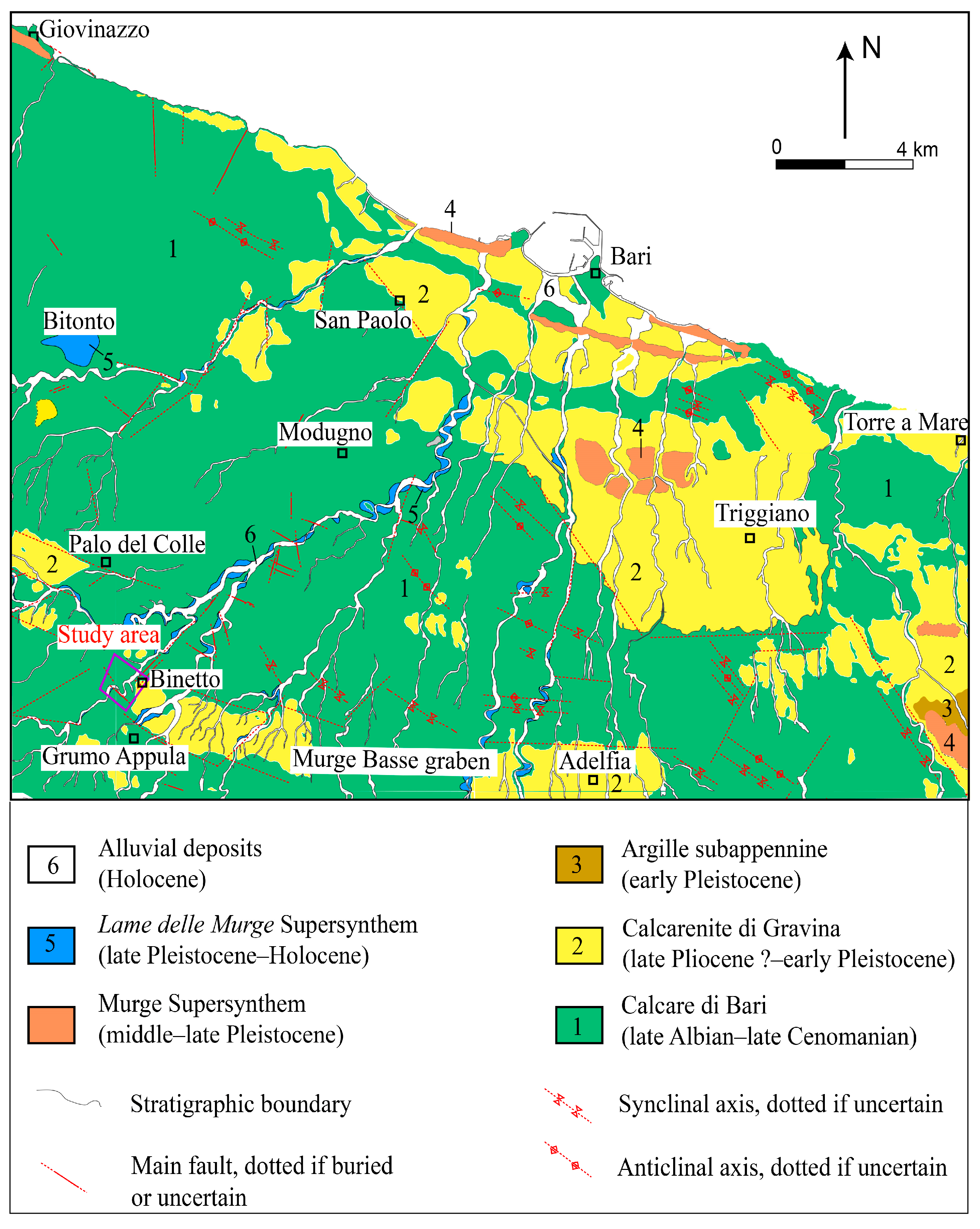
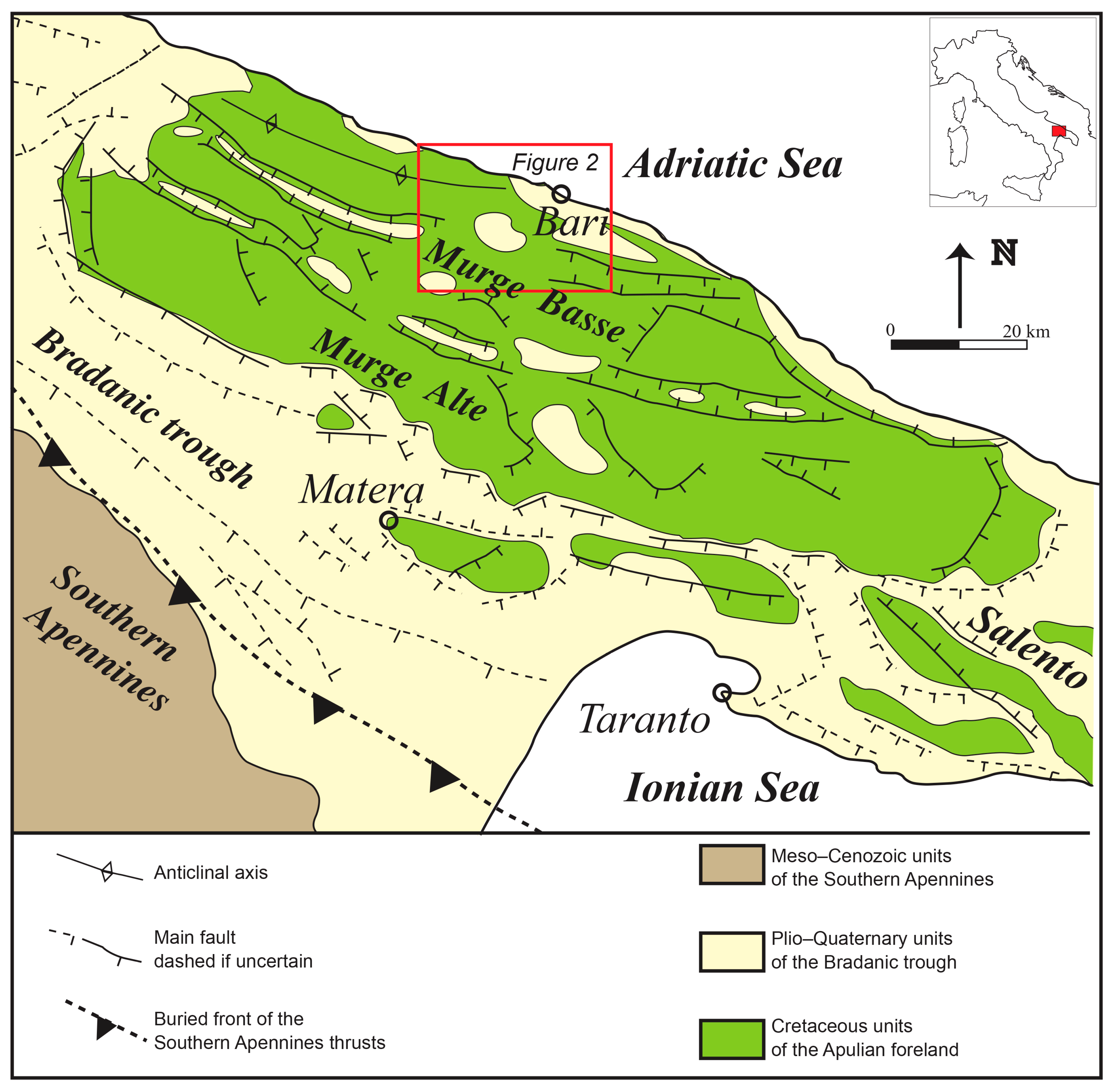
Murge is a karstic area, belonging to the central part of the southern Apennines foreland (Apulian foreland), made up of well-bedded, Cretaceous, shallow-water limestones (
Figure 1). The Murge structure corresponds to an asymmetric NW–SE trending horst and graben system [
29,
30] bordered by normal and transtensive faults inherited from late Cretaceous tectonics [
31]. The whole structure was formed by NW–SE trending morphostructural highs belonging to Murge Alte flanked to the NE (Adriatic side of Murge) by some faulted-bounded downthrown blocks belonging to Murge Basse (
Figure 1). During middle Pliocene—early Pleistocene times, this area experienced subsidence that led to the deposition of shallow-water calcarenites (Calcarenite di Gravina Fm), passing upwards to clays (Argille subappennine Fm), transgressively resting upon fractured and karstified limestones of Murge Basse. This succession belongs to the Bradanic Trough cycle [
32] and is mostly preserved inside Murge grabens [
29,
33]. Since the middle Pleistocene, Murge was uplifted leading to discontinuous outcrops at different heights and the formation of terraced marine deposits [
33,
34].
As a consequence of the peculiar geological evolution, Murge Alte forms a relict tropical-type karst landscape partially modified by the headwater migration of the hydrographic network during uplift [
4,
35]. On the contrary, the main morphologic characteristic of Murge Basse is the presence of a staircase of marine terraces, gentle sloping to the NE, linked by small scarps subparallel to the coastline. These terraces were formed from the middle Pleistocene onwards, due to the superimposition of regional uplift and glacio-eustatic sea level changes [
34]. A relict drainage network characterized by several generations of incised valleys, dissect the sequence of marine terraces. The formation of these valleys has been related to complex and cyclical phenomena: (i) superimposition, since the fluvial net took place on Plio-Pleistocene covers before cutting Cretaceous limestones, and/or antecedence [
36,
37,
38,
39]; (ii) combined effects of surface running water and karstic processes [
40]; (iii) enlargement of tectonic fractures due to karstic-driven processes [
41] and (iv) sapping processes due to the combination of Murge uplifting and Quaternary glacio-eustatic sea-level changes [
42]. Another peculiar feature of the Murge area is the well-developed surface drainage network in Murge karst, which is related to the high absorption and drainage capacity of the carbonate rocks cropping out in the Apulia region and, in addition, to the climatic conditions that determine rainfall to be concentrated in autumn and winter months [
5].
The study area is located on the Adriatic side of Murge and it is shown as a purple polygon in the geological 438 Sheet “Bari” (
Figure 2). The geology can be summarized as follows: (i) the Cretaceous bedrock consists of late Albian-late Cenomanian limestones and dolostones of the Calcare di Bari Fm; (ii) late Pliocene ?—early Pleistocene carbonate soft rocks of the Calcarenite di Gravina Fm resting transgressively upon the Cretaceous bedrock, and are mostly preserved in morphostructural lows; (iii) conformably succeeded by early Pleistocene clays of the argille subappennine Fm; (iv) middle-late Pleistocene, marine terrace deposits of the Murge Supersynthem unconformably overlying all older units; (v) late Pleistocene–Holocene alluvial terraced deposits of the Lame delle Murge Supersynthem crop out at different heights along incised valleys and (vi) Holocene alluvial deposits crop out in valley bottoms.
Hydrologically, the study area belongs to the catchment of Bari comprising the city of Bari and surrounding towns (
Figure 3). “Lame” crossing this area are characterized by low drainage density values and a low hierarchic organization, forming simple catchments and watersheds [
11,
17]. They are roughly rectilinear, regularly spaced, characterized by a flat bottom, and with a 25–30°N preferred orientation, developed approximately perpendicular to the coastline. Notwithstanding their origin is still debated, the development of these valleys is primarily controlled by the dip of the regional slope and secondarily by tectonic structures [
17].
4. Results
4.1. Geological and Geomorphological Field Survey
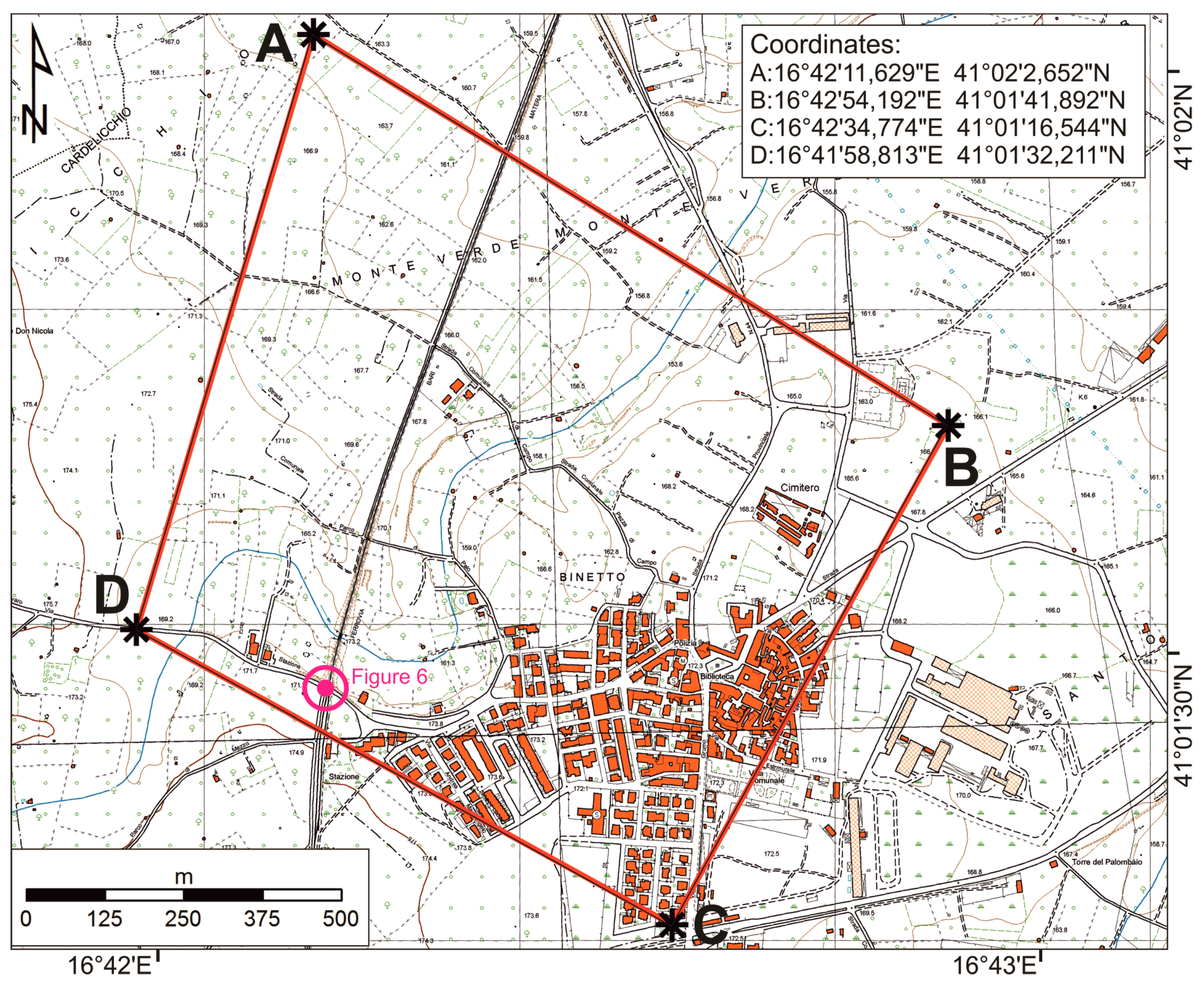
The study area extends for a total area of about 1 km
2, it is represented through a polygon of four vertices, the coordinates of which (reference system UTM WGS84 33N zone) are shown in
Figure 4.
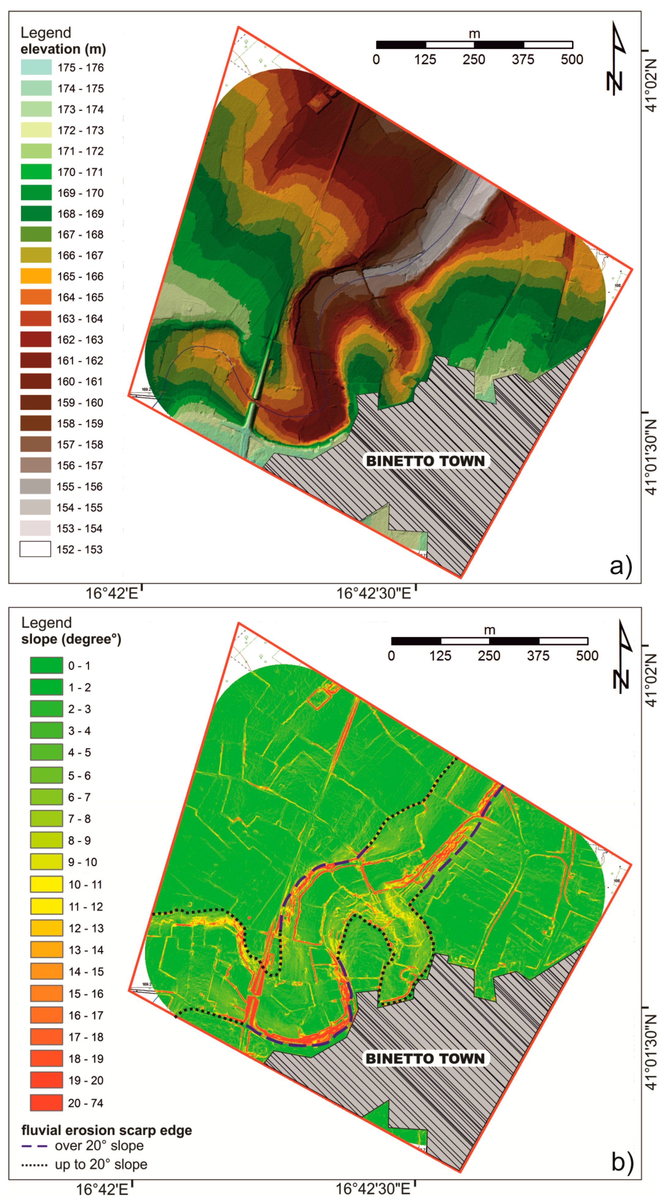
According to the trend of the regional slope, the study area shows the highest elevation, about 173 m a.s.l., in the southern part close to the Binetto town-center, and a gradual altimetric decrease, to the N/NE, to about 157 m a.s.l. Overall, it is a low-relief landscape corresponding to an ancient (wave cut) platform crossed by the incised valley of the Lama Lamasinata. The elevation of the valley bottom decreased along the flow path from about 167 m a.s.l. to about 152 m. The studied terrains were characterized by a barely to poorly pronounced morphology, with a difference in height between the valley bottom and the fluvial scarp edges comprised between a few meters and 10 meters.
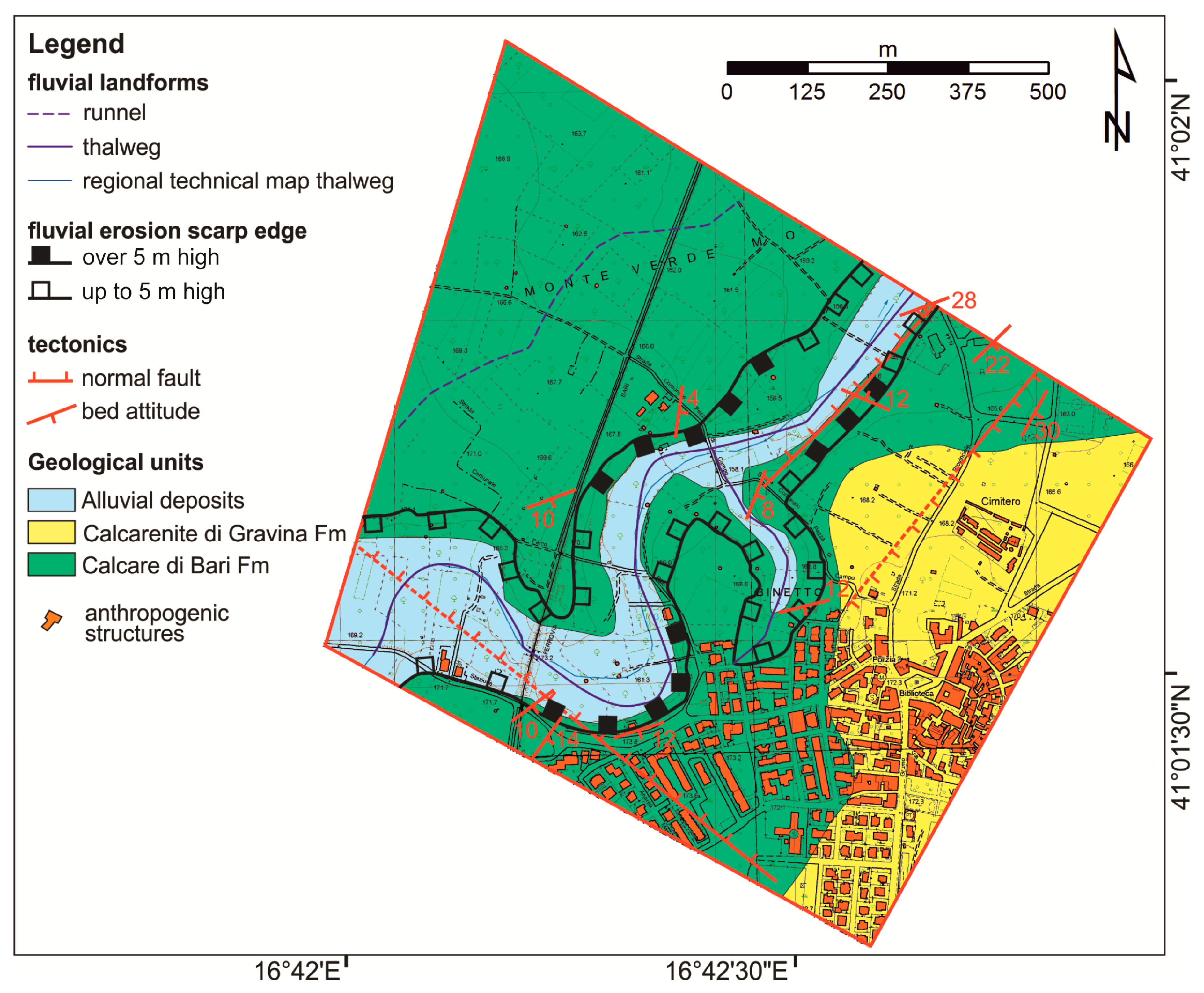
Similarly to other “lame” crossing Murge Basse, Lama Lamasinata drainage network shows a 25–30°N roughly rectilinear orientation (
Figure 3). However, in the study area, this lama shows an upstream entrenched meandering sector passing downstream to a sector showing an almost regular rectilinear orientation (
Figure 4). The entrenched meander shows a length of about 550 m and an amplitude of 350 m. Along the right side-valley of Lama Lamasinata a small tributary forming an incised valley occurs. A small channel crosses the northern sector of the study area (
Figure 5).
Lama Lamasinata crosses a tectonic depression corresponding to the regional structure of the Murge Basse graben (sensu [
30],
Figure 2). This structure is one of the most important tectonic elements of Murge, deforming Cretaceous limestones and creating the accommodation space for the post-rift sedimentation of the Plio-Quaternary units. Cretaceous limestones are well-bedded, jointed, and form a monocline gently dipping to SE (dip values comprised between 4° and 10°). Normal faults significantly modify bed attitudes and/or increase dipping (>10°). In more detail, a normal fault, 125°N oriented, has been identified in the southern part of the study area crossing both scarp edges of Lama Lamasinata (
Figure 5). It belongs to the main fault system of the Murge Basse graben structure. Two more subvertical normal faults have been identified in the eastern sector of the study area, they are about 30°N oriented and plunge to NW and SE respectively (
Figure 5). These faults belong to a younger tectonic phase than one forming the graben [
18]. Part of the right side-valley of Lama Lamasinata is set up along the fault surface of one of these latter faults, the one plunging to NW and forming a steep fault escarpment.
Lama Lamasinata cuts both Cretaceous and Plio-Quaternary units and the riverbed is set up onto Cretaceous limestones. Up to 2 m thick, gravelly- to pebbly-sized alluvial deposits in a matrix of reddish-brown residual soils (the so-called terra rossa) are found in the valley bottom.
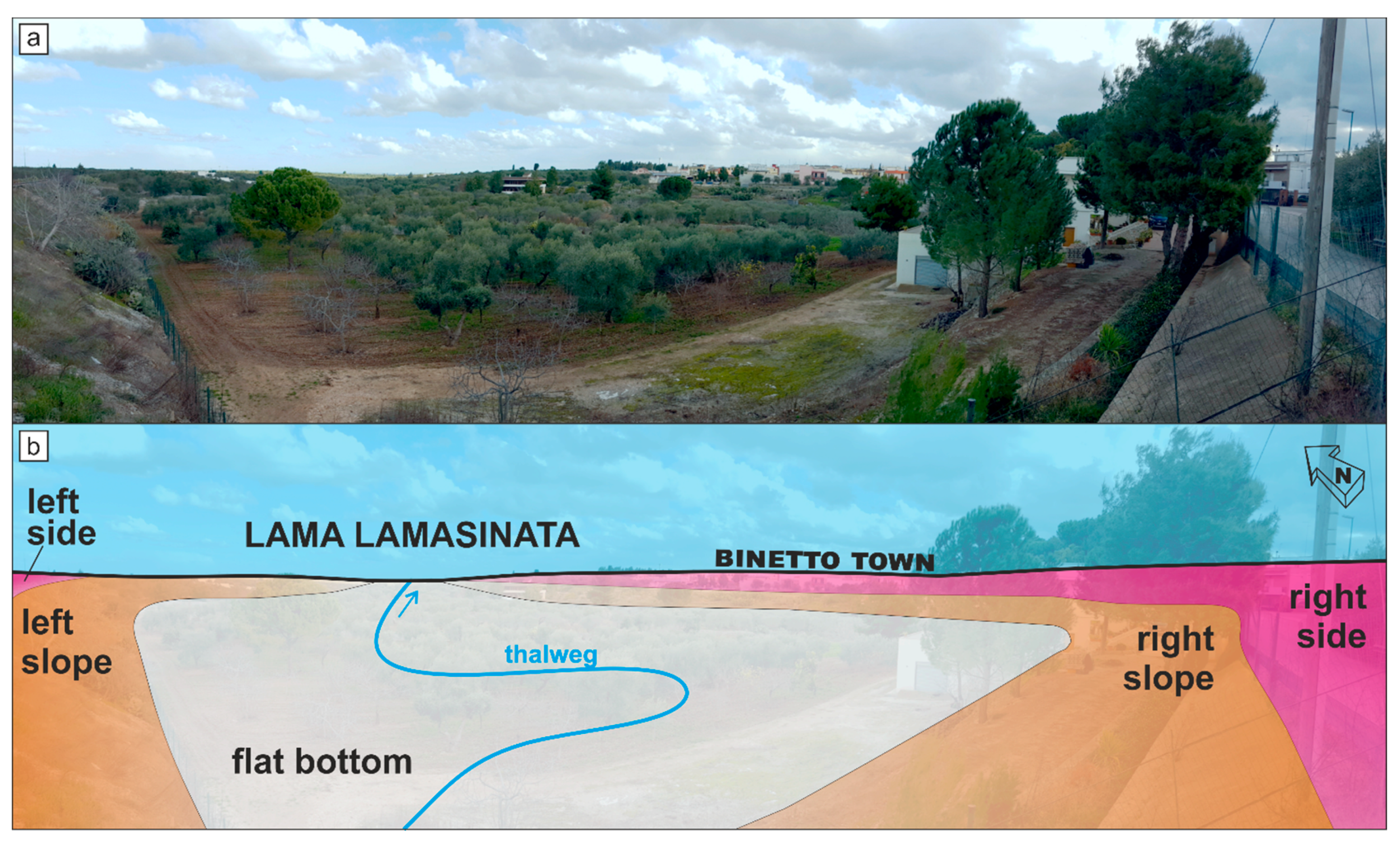
Even though landforms are generally gentle and even the most pronounced slopes are absorbed with a constant decrease in elevation (
Figure 6), steeper scarps are present along concave banks, in the meandering sector, and along the fault escarpment. Along these scarps, it is possible to observe some outcrops of the Cretaceous limestones. Convex scarp edges and tectonically undisturbed ones show less steep scarps (<10–12°). Some graphical artifacts related to slope peaks have been observed along the railway bridge, roads, dry-stone-walls and others anthropogenic structures.
4.2. Landform Classification Based on High-Resolution DSM
In order to achieve some significant morphological parameters from the DSM, a first step was the extraction of contour lines with a vertical spacing of 1 m. Contour lines allowed us to create a triangulated irregular network (TIN) model (
Figure 7). Extraction of surface height from a DSM is a complicated procedure which can produce errors and artefacts (see for example [
43]) during filtering processes of buildings and other artificial structures. Our reconstruction was mainly focused on the poorly-urbanized areas of the lama and surrounding slopes, thus we argued that the recognition of the main landforms of these sectors could be reasonably made on the available DSM.
The adopted methodology for constructing a TIN model from a raster-based digital surface model (DSM) preserved critical hydrologic features in the terrain, indeed, looking at this model it was possible to capture the topography, drainage network and floodplain area, appreciating most of the morphological features already outlined during the field survey.
As a matter of fact, the studied terrains arises on a sub-planar area, characterized by a regular contour lines trend, showing a gradual elevation decrease to the N/NE. Lama Lamasinata shows, upstream in the meandering sector, a cross section about 270 m wide; whereas, downstream in the rectilinear sector, cross sections changes in width between 130 m and 180 m. The incised valley has a more articulated right side, showing a total length of about 1520 m, because of the presence of the small tributary channel (about 100 m long), whereas the left side-valley is about 1200 m long (
Figure 7a). The thalweg has a total length of about 1520 m, with an average slope along its length of about 11%. The recognition of the thalweg in the field was not always evident since the sediments of alluvial plain were ploughed and deeply reworked for the needs of local agricultural activities (
Figure 6a).
In order to verify the results of the geomorphological field survey, and for a more accurate mapping of the floodplain of Lama Lamasinata, a semi-automatic classification of landforms was performed based on the slope raster and the TPI. Visual inspection of the slope map highlighted that the highest values of slope class could be observed along the axis of Lama Lamasinata (
Figure 7b). These peaks are located along slightly pronounced scarps, discriminating the real physical boundary of the mapped landforms. Slope peaks observed on the slope raster map corresponded to the fluvial erosion scarp edges mapped in
Figure 5. Both sides of Lama Lamasinata show slightly pronounced morphological scarps; the maximum slope values are about 25–30° in correspondence to the concave scarp edges of the entrenched meander and along the fault escarpment (
Figure 7b).
Following the procedures proposed by References [
14,
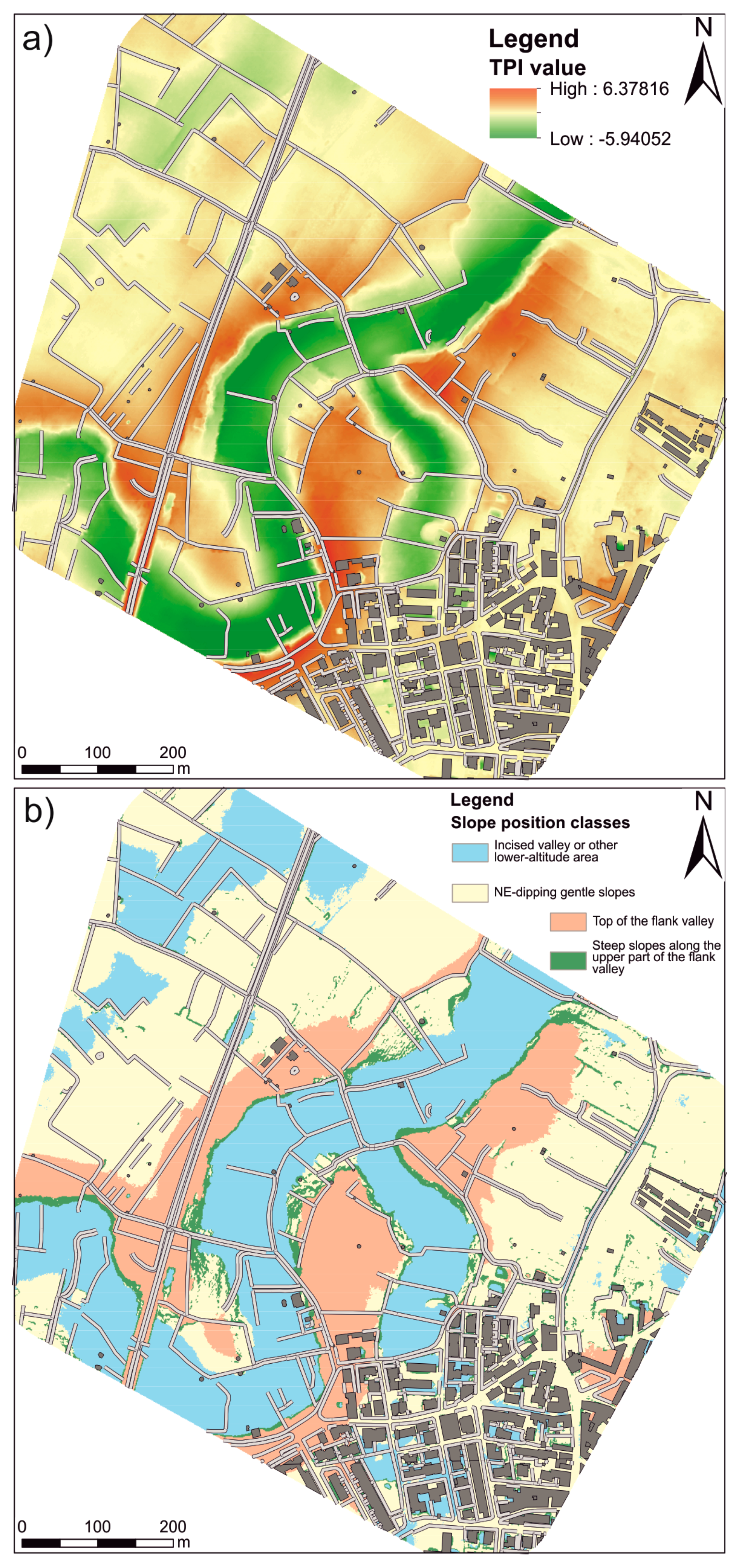
26], we extracted the TPI of the study area using different searching radii. By combining statistical analysis of the TPI (i.e., analysis of the frequency distribution for the different neighbourhood sizes) and “expert” observation of the map, we selected the TPI map with a radius size of 90 m as the more accurate for the recognition of the fluvio-karst landform of the study area. This map (
Figure 8a) shows the distinction between depressed areas (TPI value lower than −2.0,
Figure 8a) and areas higher than their surroundings (higher intensity of the reddish tones in the graduated scale,
Figure 8a). Indeed, higher values of the TPI map corresponded to the top of the landscape where the valley flanks are steeper.
Analysis of the frequency distribution of the TPI map allowed us to identify the threshold value useful to distinguish the different landform unit of the study area. In particular, the mean value and standard deviation of the histogram of the TPI raster have been used to differentiate between fluvial areas and sectors of the study area located at the top of the incised valley. Specifically, we selected the threshold values of −0.2 for the delimitation of the incised valley and other lower-elevation areas whereas the cell values higher than 0.8 were related to the landscape sectors located at the top of the lower elevation areas. Cell values ranging from −0.2 to 0.8 were classified as gentle or steeper slopes in relation to their slope class. More specifically, the threshold value of 5° in the slope map was the additional parameters used to identify the steeper sectors of the flanks of Lama Lamasinata valley.
Results of the semi-automatic classification of landscape and relative landform units are reported in
Figure 8b. This map highlights the two flanks of the side-valley of the lama: in particular, the left side-valley shows a defined scarp in shadow, except for the northeastern part characterized by a gentler slope (
Figure 8b). Depressed areas allowed us to constrain the boundary of the floodplain of Lama Lamasinata, generally oriented SW–NE, which, showed the character of an incised valley. The map allowed us to distinguish the areas of the Lama Lamasinata that can be occasionally affected by flooding processes due to topographic features.
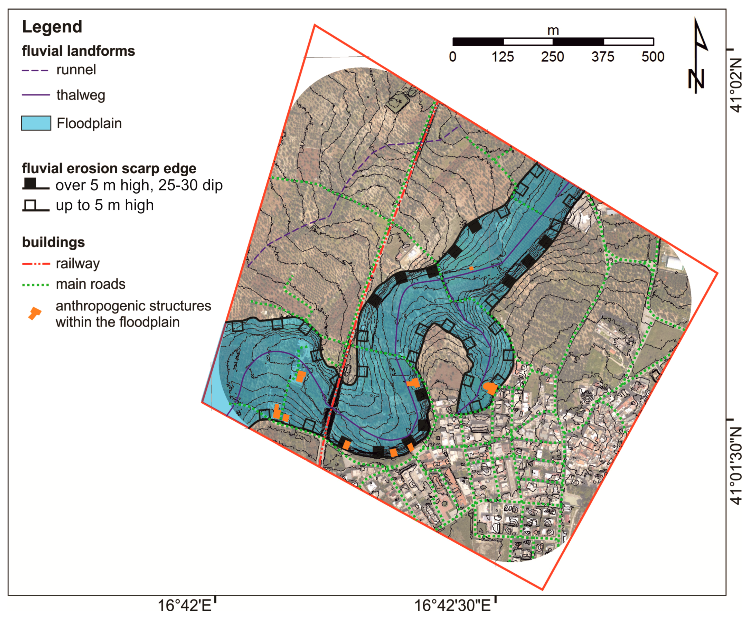
Summing up, the combined analysis of geological and geomorphological field-based data and geospatial, DSM-based details, allowed us to obtain an integrated geomorphological map showing, with a high level of reliability, the representation of fluvial landforms of Lama Lamasinata (
Figure 9). The main result was the accurate mapping of the floodplain of Lama Lamasinata. Moreover, the map showed the occurrence of residential buildings, roads, railway and other anthropogenic structures in the floodplain outlining a significant hydrogeological risk for the study area.
4.3. Landform Classification of the Lama Lamasinata Catchment
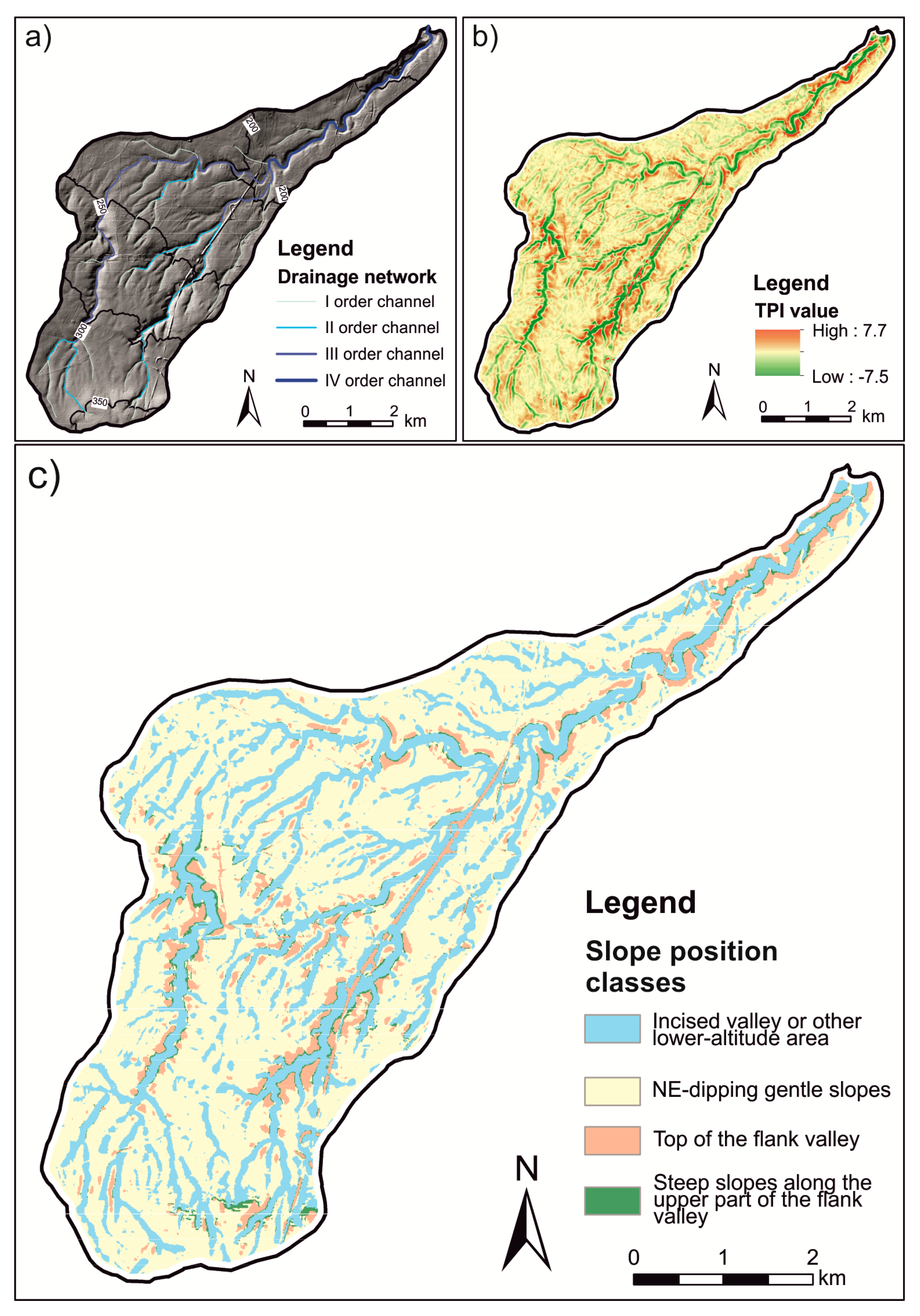
The comparison between the results of the automatic landform classification and field-based geomorphological analysis suggested a viable prediction ability of the TPI-based classification in the recognition and delimitation of the main landforms of a local reach of the Lama Lamasinata. In order to test if the adopted procedure could be a reliable and fast method to delineate the main landforms of the Murge area, TPI and SPI classifications were applied to the entire catchment of the Lama Lamasinata. The fourth-order catchment covers a total area of about 30km
2 and is featured by a planimetric shape stretched in WSW–ENE direction. Gently-dipping landscape is carved by a well-developed drainage network, which is arranged according to a parallel pattern (
Figure 10a) and cuts the Cretaceous limestone and, in a minor extent, the Pliocene–Pleistocene mixed lithoclastic–bioclastic carbonates of the Calcarenite di Gravina Fm. Main incised valleys of the catchment flow along the 25–30°N preferred orientation and are featured by a sub-vertical rocky flank and a flat bottom [
17]. Another peculiar element of this relatively homogeneous landscape is the presence of several relict valleys that end sharply, crossing sub-horizontal areas located at different elevations above the sea level. They could be interpreted as a relict drainage network related to ancient (i.e., Middle to Upper Pleistocene) sea-levels [
17].
Figure 10b shows the results of the application of the TPI with a search radius of 90 m. Although we used a coarser-resolution DEM and extended the analysis at a sub-regional scale, the map well portrayed both the main fluvio-karstic landfoms of the study area (lowest TPI values, cf.
Figure 10a,b) and the steeper rocky scarps of the incised valleys. Lower TPI values could be also correlated to the relict channels, which are frequently hard to recognize by classical analysis of topographic maps. Using the same threshold parameters of the test area surrounding the Binotto town, we extracted the four slope position classes and the relative classification of the study area (
Figure 10c).
5. Discussion
The use of integrated fieldwork, analysis of DEM-related landscape parameters and extraction of landform units is a robust methodology in detailed geomorphological analyses (e.g., [
44,
45]). This approach was applied to a case study that could be considered as a representative sector of the Murge Basse, since the incised valley took place on Plio–Pleistocene calcarenites before cutting Cretaceous limestones for super-imposition and/or sapping processes. The results of this work are here compared with available published maps, in order to remark the robustness of this methodology in mapping fluvial landforms with respect to other approaches.
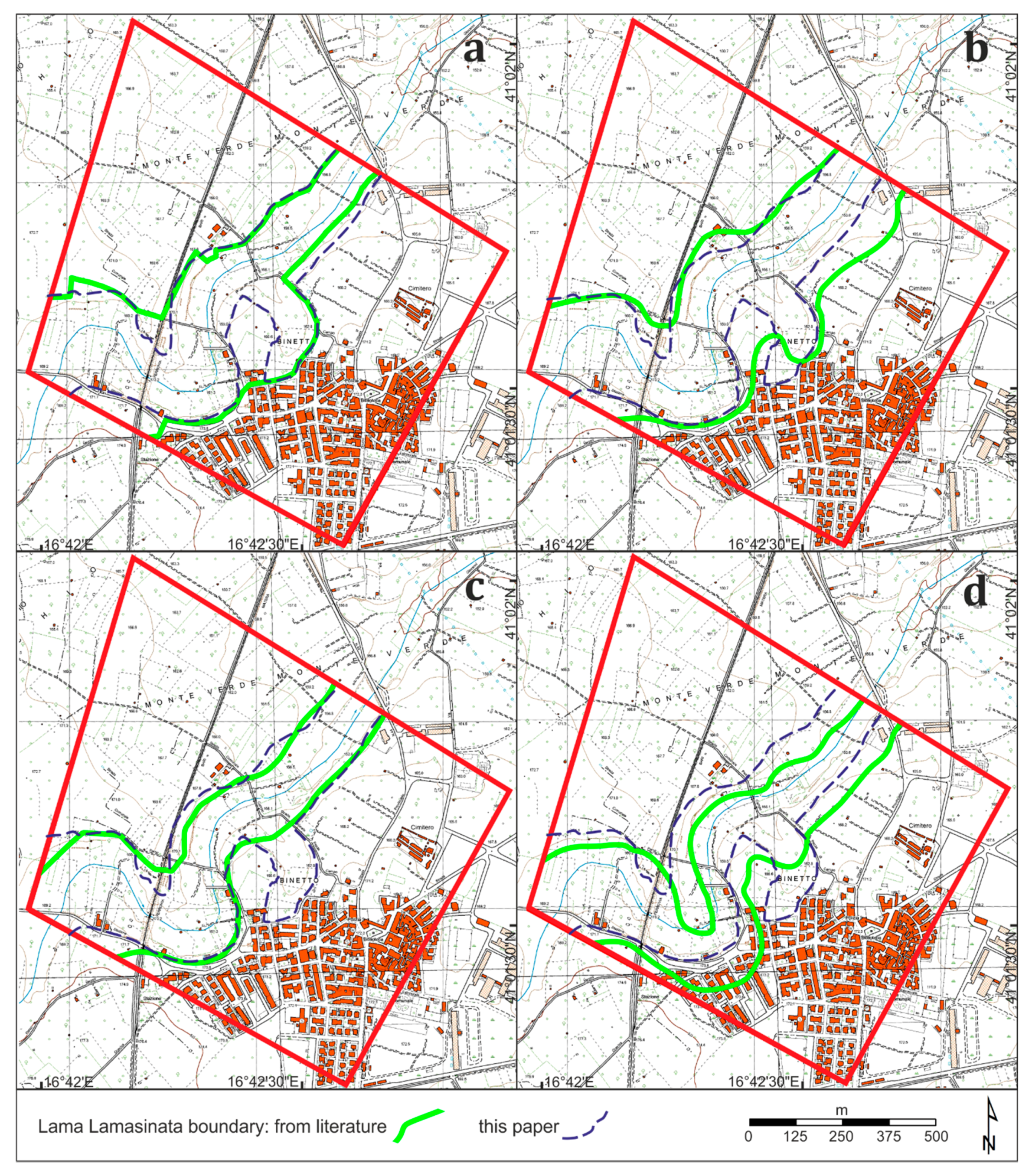
The comparison among the above-mentioned maps highlighted a relatively wide subjectivity in mapping the main morphological features. For instance, in the study area, fluvial scarp edges of Lama Lamasinata have been mapped in four different ways (
Figure 11).
This difference in the cartographic representation of the same landform may be related to several aspects, among which the final purpose of the maps, the different scale of representations, and the approaches followed for mapping this landform are the main reasons to explain the observed differences. In
Figure 11, in order to outline the differences, published cartographic fluvial scarp edges have been redrawn and digitized over the CTR and compared with those ones mapped in this study.
As a matter of fact, fluvial scarp edges of Lama Lamasinata have been mapped for: (i) environmental and/or naturalistic purposes (PPTR of the Apulia Region) based on morphological boundaries already mapped in cadastral or regional technical maps (CTR) at the scale 1:5000 (
Figure 11a); (ii) mapping geomorphological features of the whole Apulian territory (hydro-geomorphological map of the Apulia region) based on previously published geological and geomorphological datasets and on photo-interpretation of stereographic analogic pictures (scale 1:13,000) (
Figure 11b); (iii) mapping hydraulic hazard (Basin Authority of Apulia region 2012), mostly based on morphological data extracted using GIS applications from a freely available regional DSM (8 m per cell) (
Figure 11c) and (iv) mapping fluvial landforms (scale 1:50,000) in relation to the geological setting in the Murge Basse karst of Apulia [
17], based on field-work and on a multitemporal photo-interpretation of analogic stereographic pictures (scale 1:33,000,
Figure 11d).
The maps listed at points (i) and (iii) are fully available on webGIS portals and can be visualized and printed at any scale. Consequently, despite this their original datasets are not always very detailed and in many cases lack field control, however, they are routinely used for manage land use activities also at a very detailed scale, which may exceed one or two orders of magnitude the original map scale. This opens a big question on the reliability of the mapped landforms, especially when these data are used for the identification of those areas characterized by a relevant hydrogeological hazard. In addition, the projection of a source map in a different coordinate system and/or inaccurate georeferentiation of raster images can introduce overlay map errors and issue of landform delineation (see for example the
Figure 11d).
This study outpaced this problem since it was already done at a very detailed scale (1:2000) combining field-work and a semi-automatic classification of landforms based on a high-resolution DSM. For instance, in
Figure 9, anthropogenic structures falling in the topographic floodplain of Lama Lamasinata have been precisely outlined, identifying those critical buildings and infrastructures for which a relevant hydrogeological risk could not be excluded.
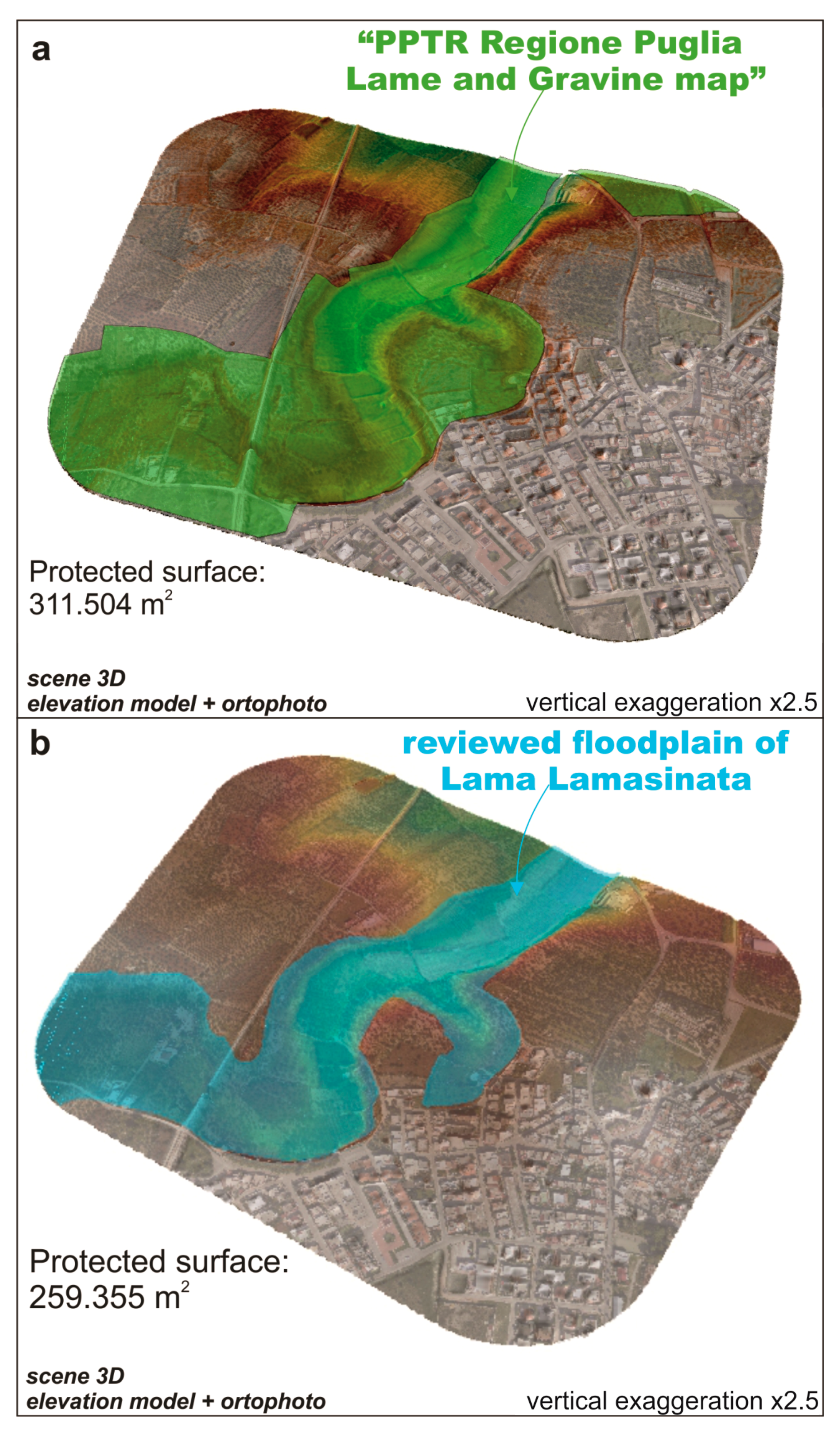
A comparison was proposed between the present study and the bounding of Lama Lamasinata, as shown in the PPTR, also as a 3D scene (
Figure 12). It arose that the bounding of Lama Lamasinata within the regional PPTR map appeared rather simplified compared to that one shown in this study. As a matter of fact, although the revised surface of the floodplain in this work (
Figure 12) involved a reduction of the current protected area of approximately 52.149 m
2 (about 16.74% less than the one bounded in the PPTR map), it solved a number of situations which appeared roughly approximate (e.g., sharp-cornered boundaries), reflecting and respecting the physical delimitation of the fluvial landform. As a result, since in the PPTR of Apulia Region floodplains of all “lame” in Murge Basse karst are considered fully protected areas, the integrated approach applied in this study gave a strong method to separate, with a high degree of reliability, those areas falling in the floodplain, fully protected as subjected to a relevant hydrogeological hazard, from those areas not directly involved in alluvial processes.
One of the main advantages of the application of algorithms for semiautomatic extraction of landforms is their ability to investigate large areas. The selection of an appropriate search radius and threshold TPI values in the local reach of the Lama Lamasinata represented the key input data to perform the landform classification at the catchment scale. Although an extensive field control was required to verify the full suitability of the results at a large scale, preliminary geomorphological analysis based on photo-aerial interpretation suggested that our results depicted all the main landform elements with a similar shape and size of those investigated in the test area. Indeed, the visual inspection of the map suggested that the landform map (
Figure 10) could represent a basic tool to recognize geomorphological elements of the Murge karstic area such as the “lame” incised valleys. These fluvio-karstic landforms are hard to recognize by classical geomorphological approaches, as demonstrated by the significant difference in the delimitation of these elements in the Lama Lamasinata reach (
Figure 11). For example, the TPI map was able to highlight several open valleys located in the north-westernmost sectors of the catchment showing subtle topographic evidences (
Figure 10c). These valleys end abruptly at an elevation of about 230–235 m a.s.l. and are not generally considered as elements of the fluvial net (
Figure 10a).
Robustness of the landform classification coming from the coarser-resolution DEM has been also statistically verified through a comparison between the two SPI maps in the local reach of the Lama Lamasinata. Quantitative analysis revealed that a relevant percentage (i.e., about the 70%) of the total area of the two maps predicted the same landform classes. About the 20% of the area with a different landform classification was related to a deviation from gentle and steep slope, suggesting that a higher resolution DEM could mainly improve the accurate delimitation of steeper slopes and landforms.
Thus, our approach could be useful to provide a preliminary—but accurate—delimitation of widespread geomorphological elements of the Murge area such as flat-bottomed valleys with steep- or gently-dipping flanks and relict incised valleys (i.e., relict channels flowing into sub-horizontal areas located at different elevations above the sea level).
6. Summary and Conclusions
This paper shows the results of an integrated methodological approach, based on a geological and geomorphological field survey, and on a TPI-based landform classification aimed at mapping, with a high degree of reliability, fluvial landforms in a sector of Murge Basse in the countryside of Binetto. The main conclusions of this study can be summarized as follows:
The qualitative description of landforms performed during the field survey were integrated by quantitative data extracted by means of GIS tools from a high-resolution DSM (1 m per cell). The adopted methodology, easily applicable in a very local context, represented a sort of new simplified approach of more complex methods described in literature for floodplain area delimitation (e.g., [
23,
24,
45,
46], among others). It combined the integrated analysis of DEM derivatives and a consolidated algorithm of extraction of landform units, that together with geomorphological field survey concurred to a more accurate definition of surface topo-hydrographic landforms and, consequently, to a more suitable delimitation of the topographic floodplain of Lama Lamasinata. These data allowed us to refine the field survey adding to the field map some additional information such as length and slope angles of fluvial scarp edges, appropriate position, length and average slope angle of the thalweg and total area of the lama sector.
The comparison of the integrated geomorphological map of this study with the available cartography of the area, showing fluvial scarp edges of Lama Lamasinata in the study area, outlined how the applied methodology led to a map having a higher level of reliability than the published ones.
DEM-based representation of the floodplain of Lama Lamasinata in the study area allowed us to bound a less wide protected area (i.e., an area directly affected by alluvial processes) than one shown in the PPTR (about 16.74% less). In spite of this, it was outlined that the proposed bounding of the floodplain would solve a number of situations which appeared roughly approximate in the PPTR (e.g., sharp-cornered boundaries) reflecting and respecting in a more realistic way the morphological features of the fluvio-karst area.
The application of the TPI- and SPI-based landform classification at a catchment scale was tested as a fast and effective approach to delineate the main landforms of the Murge area. Of course, the method needs to be tested in other karstic landscapes and/or at a sub-regional scale in order to evaluate limitations and advantages of the application of this kind of classification but the encouraging preliminary results suggest a high potential of the proposed approach.
In conclusion, the methodological work shown in this paper is considered a fundamental step for any kind of study aimed at using geomorphological information for planning an accurate land use in an area affected by a relevant hydrogeological hazard. Due to the large diffusion of high-resolution DSMs, this approach can be easily replicated in areas with similar geomorphological features, although the use of DTMs and a better calibration of the landform types at a larger scale are required to produce a more detailed landform unit map. In addition, the detailed mapping of geomorphological data is considered crucial knowledge for preserving the remaining geomorphological heritage in an area affected by a strong modification of the landscape due to human activities.
