Overlapping Damage Zones in a Bedrock Aquifer

 ,
,  , and
, and
Abstract
1. Introduction
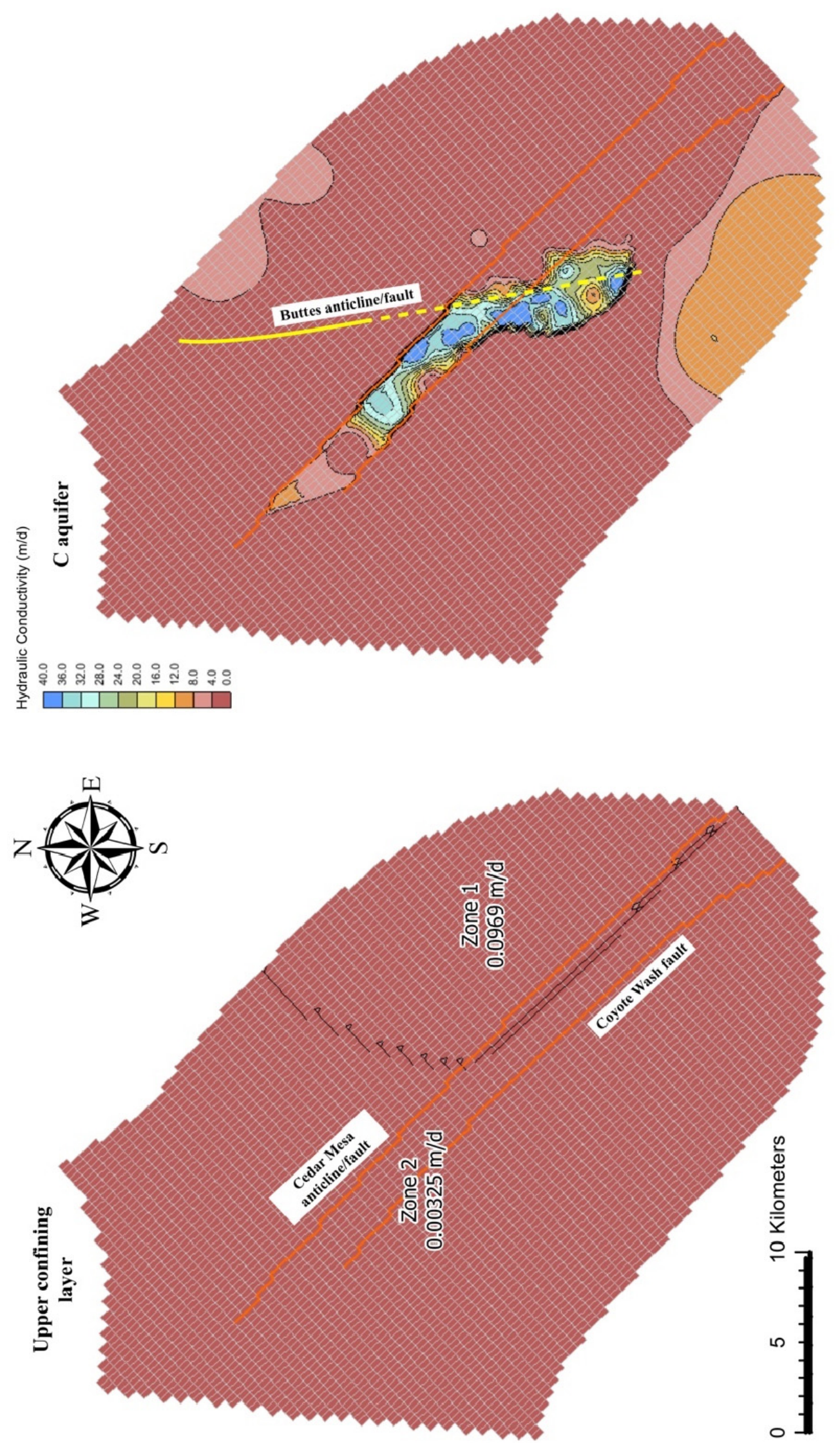
- First, starting from a baseline model built with literature-based hydraulic properties (Section 3.3), calibrate the model to identify low- and high-permeability zones in the aquifer and examine permeability distributions relative to faults. Our study builds on previous hydrological modeling [18], discussed below.
- As part of the calibration process, determine whether the Cedar Mesa anticline axis acts as a horizontal barrier to flow. In other words, does it behave like a fault, and does this behavior differ from that of the Coyote Wash fault?
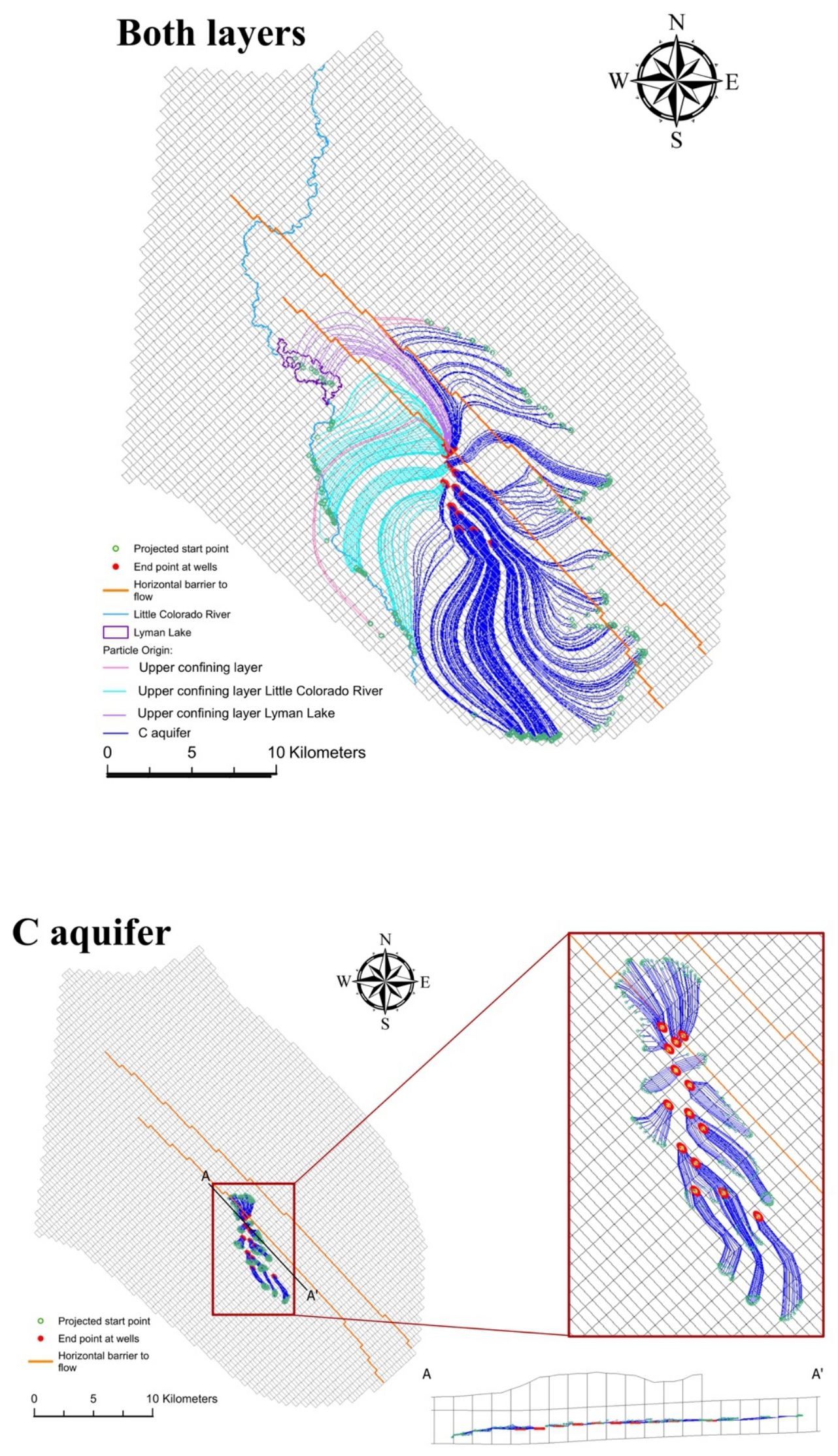
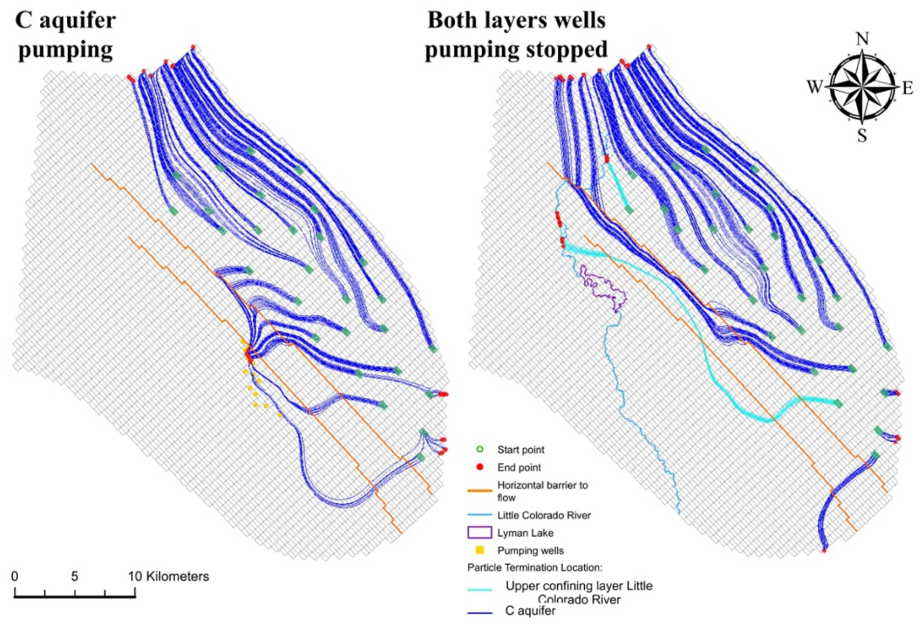
- Use particle tracking to examine likely flow pathways and flow rates in response to fault architecture and pumping.
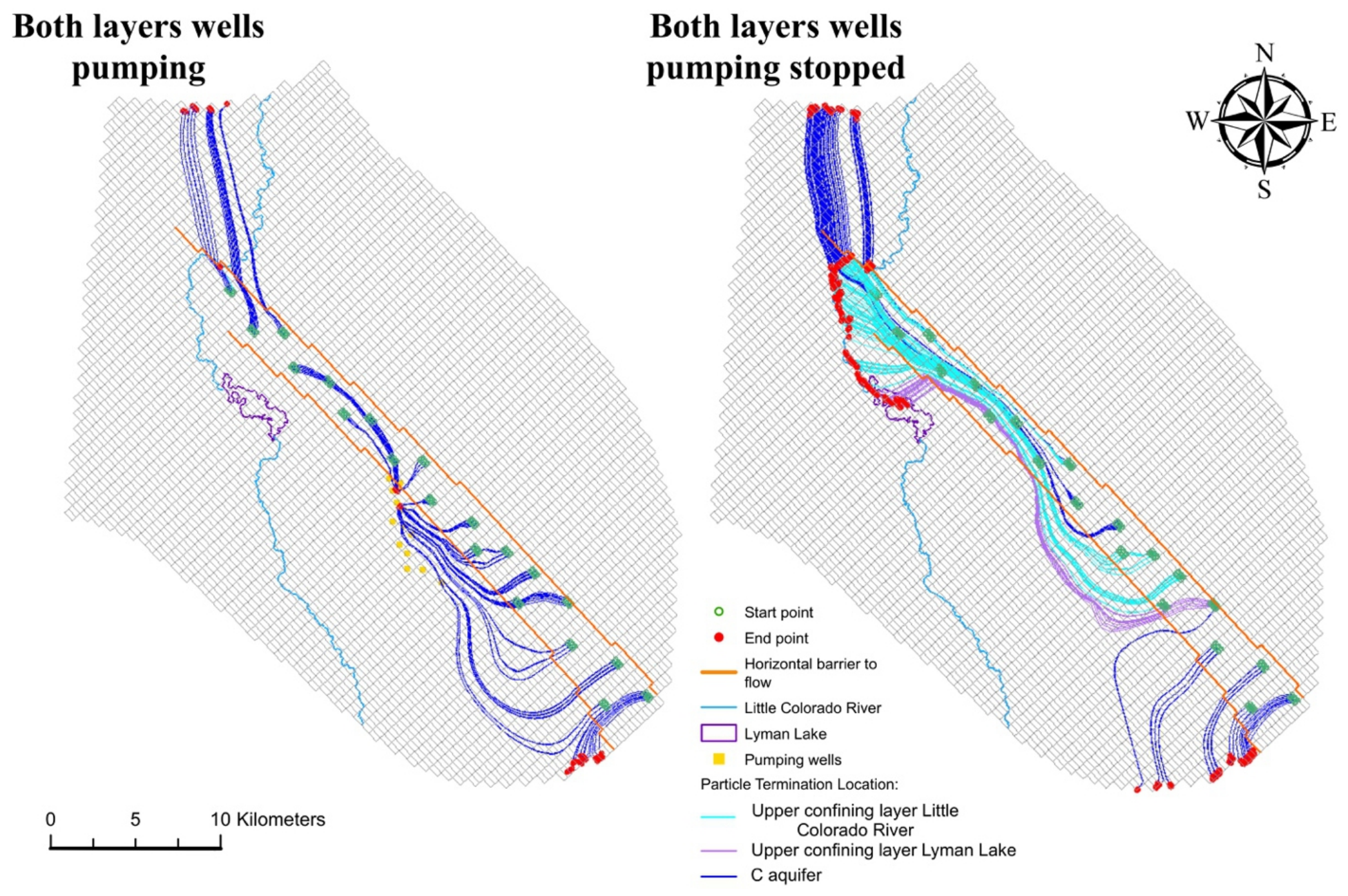
- Turn off the wells and use particle tracking to examine the response of the flow field to the absence of pumping stresses, thereby providing additional insight into how groundwater flow responds to these faults.
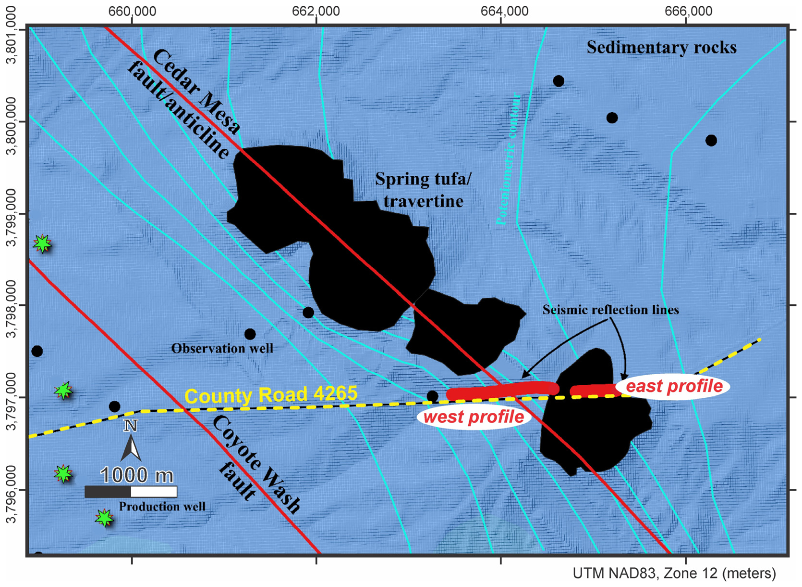
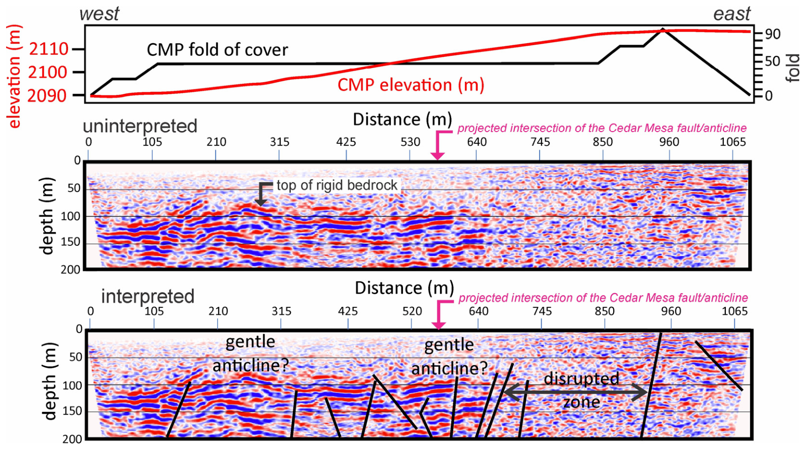
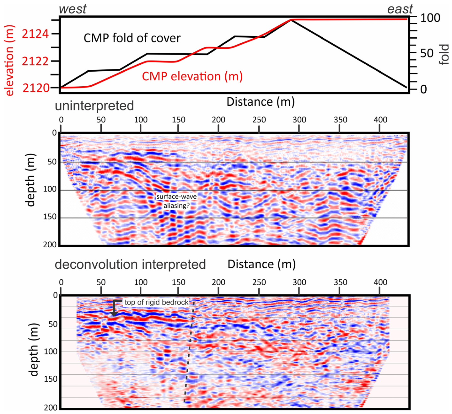
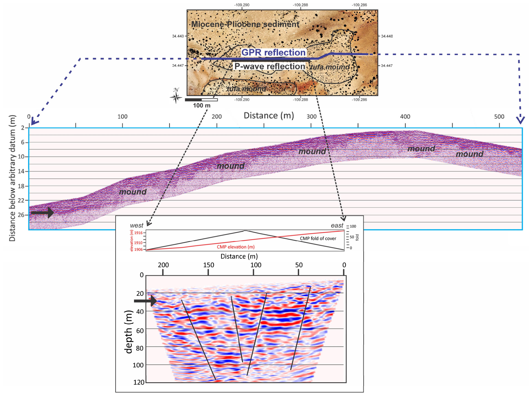
- Use seismic reflection and ground-penetrating radar (GPR) to characterize fault architecture in relation to groundwater flow.
2. Hydrogeological Setting
2.1. Regional Setting
2.2. Cedar Mesa Anticline/Fault
2.3. Hydrostratigraphy
2.4. Surface Water
2.5. Groundwater
2.6. CO2 Reservoir
2.7. Structural Control
3. Methods
3.1. Model Conceptualization and Data Sources
3.2. Three-Dimensional Hydrostratigraphy Model
3.3. Numerical Model
3.4. Model Calibration
3.5. Simulations
3.6. Seismic Reflection and GPR Surveys
4. Results
4.1. Model Results
4.2. Particle Tracking
4.2.1. Case (1)
4.2.2. Case (2)
4.2.3. Case (3)
4.3. Seismic Reflection and GPR Results
5. Discussion
5.1. Implications of the Calibrated Model
5.2. Implications of Particle Tracking
5.3. Suggestions for Further Study
6. Conclusions
Author Contributions
Funding
Data Availability Statement
Acknowledgments
Conflicts of Interest
References
- U.S. Geological Survey. Available online: https://www.usgs.gov/faqs/how-important-groundwater (accessed on 12 September 2023).
- Caine, J.S.; Evans, J.P.; Forster, C.B. Fault zone architecture and permeability structure. Geology 1996, 24, 1025–1028. [Google Scholar] [CrossRef] [Scilit]
- Caine, J.S.; Forster, C.B. Fault zone architecture and fluid flow: Insights from field data and numerical modeling. Geophys. Monogr.-Am. Geophys. Union 1999, 113, 101–128. [Google Scholar] [CrossRef] [Scilit]
- Chi, B.; Gao, K.; Li, D.; Moore, J.; Jones, C.; Huang, L. 3D seismic imaging of a fracture damage zone controlling reservoir compartmentalization at the Raft River EGS using multi-azimuth walkaway VSP. Geothermics 2026, 142, 103822. [Google Scholar] [CrossRef] [Scilit]
- İçhedef, M.; Taşköprü, C.; Sapmaz, İ.; Özen, F.; Duman, G.; Tabar, E.; Sözbilir, H.; Giammanco, S. Multi-parameter soil gas geochemistry and fracture-controlled degassing along the İzmir Fault (Western Türkiye). Appl. Geochem. 2026, 206, 106912. [Google Scholar] [CrossRef] [Scilit]
- Yang, J.; Hu, X.; Wang, H.; Zhao, Y. Study on permeability characteristics of compressive dense fault fracture zone. Yangtze River 2026, 57, 217–223. [Google Scholar] [CrossRef]
- Evans, J.P.; Forster, C.B.; Goddard, J.V. Permeability of fault-related rocks, and implications for hydraulic structure of fault zones. J. Struct. Geol. 1997, 19, 1393–1404. [Google Scholar] [CrossRef] [Scilit]
- Tsekoura, P.E.; Vasileiou, E.; Stefouli, M.; Vakalas, I.; Perraki, M. The hydrogeological and tectonic features as the crucial factors for the hydro-geochemistry of surface and groundwater in active geothermal systems: The case study of Methana Peninsula in Greece. Environ. Earth Sci. 2026, 85, 359. [Google Scholar] [CrossRef] [Scilit]
- Laubach, S.E.; Eichhubl, P.; Hargrove, P.; Ellis, M.A.; Hooker, J.N. Fault core and damage zone fracture attributes vary along strike owing to interaction of fracture growth, quartz accumulation, and differing sandstone composition. J. Struct. Geol. 2014, 68, 207–226. [Google Scholar] [CrossRef] [Scilit]
- Youssef, M.; El Younsy, A.M.; Abbas, H.; Gad, A. Multi-scale characterization of the damage zone associated with a rift-scale normal fault system. J. Struct. Geol. 2026, 207, 105676. [Google Scholar] [CrossRef] [Scilit]
- Su, X.; Gong, L.; Fu, X.; Ostadhassan, M.; Gao, S.; Wang, J.; Qin, X.; Bao, T.; Cao, D. The comprehensive control of mechanical stratigraphy and faults on fracture distribution in continental shale reservoirs. Results Eng. 2026, 29, 109319. [Google Scholar] [CrossRef] [Scilit]
- Miocic, J.M. A Study of Natural CO2 Reservoirs—Mechanisms and Pathways for Leakage and Implications for Geologically Stored CO2. Ph.D. Thesis, The University of Edinburgh, Edinburgh, UK, 2016. Available online: https://era.ed.ac.uk/handle/1842/17881 (accessed on 7 July 2023).
- Abdullah, M.; Alsalami, Z.A.; Deepak, J.; Johar, M.G.M.; Routray, A.; Karthikeyan, A.; Gill, H.S.; Sandhu, A.; Abbasi, H. Simulation study of transport dynamics of gas injection in carbonate fractured rocks. Phys. Chem. Earth Parts A/B/C 2026, 145, 104736. [Google Scholar] [CrossRef] [Scilit]
- Heidbach, O.; Rajabi, M.; Reiter, K.; Ziegler, M. World Stress Map 2016. GFZ Data Services 2016. [Google Scholar] [CrossRef] [Scilit]
- U.S. Geological Survey and Arizona Geological Survey, Quaternary Fault and Fold Database for the United States. Available online: https://www.usgs.gov/natural-hazards/earthquake-hazards/faults (accessed on 20 July 2026).
- Miocic, J.M.; Gilfillan, S.M.V.; Frank, N.; Schroeder-Ritzrau, A.; Burnside, N.M.; Haszeldine, R.S. 420,000 year assessment of fault leakage rates shows geological carbon storage is secure. Sci. Rep. 2019, 9, 769. [Google Scholar] [CrossRef] [Scilit] [PubMed]
- Jones, C.J.R.; Robinson, M.J. Groundwater and Surface-Water Data from the C-Aquifer Monitoring Program, Northeastern Arizona, 2012–2019; U.S. Geological Survey Open-File Report 2021–1051; U.S. Geological Survey: Reston, VA, USA, 2021. [CrossRef] [Scilit]
- Keating, E.; Newell, D.; Dempsey, D.; Pawar, R. Insights into interconnections between the shallow and deep systems from a natural CO2 reservoir near Springerville, Arizona. Int. J. Greenh. Gas Control 2014, 25, 162–172. [Google Scholar] [CrossRef] [Scilit]
- Sirrine, K.G. Geology of the Springerville-St. Johns Area, Apache County, Arizona. Ph.D. Thesis, University of Texas, Austin, TX, USA, 1958. Available online: https://search.lib.utexas.edu/permalink/01UTAU_INST/q482hd/alma991055315349706011 (accessed on 1 August 2025).
- Embid, E.H. U-Series Dating, Geochemistry, and Geomorphic Studies of Travertines and Springs of the Springerville Area, East-central Arizona, and Tectonic Implications. Master’s Thesis, University of New Mexico, Albuquerque, NM, USA, 2009. Available online: https://digitalrepository.unm.edu/eps_etds/26/ (accessed on 1 June 2022).
- Aldrich, M.J.; Laughlin, A.W. A model for the tectonic development of the southeastern Colorado Plateau boundary. J. Geophys. Res. Solid Earth 1984, 89, 10207–10218. [Google Scholar] [CrossRef] [Scilit]
- Mnich, M.E.; Condit, C.D. Toward a Four-Dimensional Petrogenetic Model of a Distributed Volcanic Field on the Southern Edge of the Colorado Plateau, Chap; N Poland, M.P., Ort, M.H., Stovall, W.K., Vaughan, R.G., Connor, C.B., Rumpf, M.E., Eds.; Distributed volcanism—Characteristics, processes, and hazards: U.S. Geological Survey Professional Paper 1890; U.S. Geological Survey: Reston, VA, USA, 2026; 25p. [CrossRef] [Scilit]
- Karlstrom, K.E.; Wilgus, J.; Thacker, J.O.; Schmandt, B.; Coblentz, D.; Albonico, M. Tectonics of the Colorado Plateau and Its Margins. Ann. Rev. Earth Planet. Sci. 2022, 50, 295–322. [Google Scholar] [CrossRef] [Scilit]
- Crumpler, L.S.; Aubele, J.C.; Condit, C.D. Volcanoes and Neotectonic Characteristics of the Springerville Volcanic Field, Arizona. In Mogollon Slope, West-Central New Mexico and East-Central Arizona; Chamberlin, R.M., Kues, B.S., Cather, S.M., Barker, J.M., McIntosh, W.C., Eds.; New Mexico Geological Society 45th Annual Fall Field Conference, 28 September–1 October 1994; New Mexico Geological Society: Socorro, NM, USA, 1994; pp. 147–164. [Google Scholar] [CrossRef] [Scilit]
- ADEQ (Arizona Department of Environmental Quality). St. Johns Gas Unit (Stimulated Carbon Dioxide Wells): Arizona Department of Environmental Quality Aquifer Protection Permit 511308. 2016. Available online: https://azdeq.gov/permits/IndividualAPP (accessed on 5 July 2023).
- Moore, J.; Adams, M.; Allis, R.; Lutz, S.; Rauzi, S. Mineralogical and geochemical consequences of the long-term presence of CO2 in natural reservoirs: An example from the Springerville–St. Johns Field, Arizona, and New Mexico, USA. Chem. Geol. 2005, 217, 365–385. [Google Scholar] [CrossRef] [Scilit]
- Gilfillan, S.M.V.; Ballentine, C.J.; Holland, G.; Blagburn, D.; Lollar, B.S.; Stevens, S.; Schoell, M.; Cassidy, M. The noble gas geochemistry of natural CO2 gas reservoirs from the Colorado Plateau and Rocky Mountain provinces, USA. Geochim. Cosmochim. Acta 2008, 72, 1174–1198. [Google Scholar] [CrossRef] [Scilit]
- Craddock, W.H.; Blondes, M.S.; DeVera, C.A.; Hunt, A.G. Mantle and crustal gases of the Colorado Plateau: Geochemistry, sources, and migration pathways. Geochim. Cosmochim. Acta 2017, 213, 346–374. [Google Scholar] [CrossRef] [Scilit]
- Burnside, N.M. U-Th Dating of Travertines on the Colorado Plateau: Implications for the Leakage of Geologically Stored CO2. Ph.D. Thesis, University of Glasgow, Glasgow, UK, 2010. Available online: https://gla.on.worldcat.org/oclc/664328234 (accessed on 8 June 2022).
- Rauzi, S.L. Carbon Dioxide in the St. Johns—Springerville Area, Apache County, Arizona. Arizona Geological Survey Open-File Report 99–2. 1999. Available online: https://library.azgs.arizona.edu/item/AOFR-1552429763526-134 (accessed on 5 July 2025).
- Stevens, S.H.; Tye, B.S. NACS—Natural CO2 Analogs for Carbon Sequestration; U.S. Department of Energy 2007, Under U.S. Department of Energy Award no. DE-FC26-01NT41150; Advanced Resources International, Inc.: Arlington, VA, USA. [CrossRef] [Scilit]
- Keating, E.; Newell, D.; Stewart, B.; Capo, R.; Pawar, R. Further insights into interconnections between the shallow and deep systems from a natural CO2 reservoir near Springerville, Arizona, USA. Energy Procedia 2014, 63, 3195–3201. [Google Scholar] [CrossRef] [Scilit]
- Keating, E.H.; Newell, D.L.; Viswanathan, H.; Carey, J.W.; Zyvoloski, G.; Pawar, R. CO2/brine transport into shallow aquifers along fault zones. Environ. Sci. Tech. 2013, 47, 290–297. [Google Scholar] [CrossRef] [Scilit] [PubMed]
- Montgomery and Associates, Appendix A, construction details for new CCR monitoring wells, January–April 2016. Tucson Electric Power 2016. Available online: https://docs.tep.com/wp-content/uploads/2019/02/2018_sgs_ccr_groundwater_monitoring_annual_report.pdf (accessed on 1 August 2025).
- Hammond, J.; Tucson Electric Power (TEP), Springerville, AZ, USA. Personal communication, 2019.
- Akers, J.P. Geology and Ground Water in the Central Part of Apache County, Arizona; U.S. Geological Survey Water-Supply Paper 1771; U.S. Geological Survey: Reston, VA, USA, 1964. [CrossRef] [Scilit]
- Foust, R.D.; Brandstrom, M.; Evans, G.; Nez, P.; Waupoose, D.; Hillman, E. Source identification for groundwater arsenic in the Verde Valley, Central Arizona, USA. Trace Met. Other Contam. Environ. 2007, 9, 85–100. [Google Scholar] [CrossRef] [Scilit]
- Hart, R.J.; Ward, J.J.; Bills, D.J.; Flynn, M.E. Generalized Hydrogeology and Ground-Water Budget for the C Aquifer, Little Colorado River Basin and Parts of the Verde and Salt River Basins, Arizona and New Mexico; U.S. Geological Survey Water-Resources Investigations Report 2002–4026; U.S. Geological Survey: Reston, VA, USA, 2002. [CrossRef] [Scilit]
- Mann, L.J.; Nemecek, E.A. Geohydrology and Water Use in Southern Apache County, Arizona. Arizona Department of Water Resources Bull. 1, 5 Sheets, Scales 1:250,000 and 1:500,000. 1983. Available online: https://azmemory.azlibrary.gov/nodes/view/91162 (accessed on 15 July 2025).
- Montgomery and Associates, Hydrogeologic Monitoring Program 2018–2019, Springerville Generating Station, Apache County, Arizona. Tucson Electric Power. 2019. Available online: https://docs.tep.com/wp-content/uploads/2019_groundwater_monitoring_and_corrective_action_report.pdf (accessed on 1 August 2025).
- Leake, S.A.; Hoffman, J.P.; Dickinson, J.E. Numerical Ground-Water Change Model of the C Aquifer and Effects of Ground-Water Withdrawals on Stream Depletion in Selected Reaches of Clear Creek, Chevelon Creek, and the Little Colorado River, Northeastern Arizona; US Geological Survey Scientific Investigation Report 2005–5277; U.S. Geological Survey: Reston, VA, USA, 2005; 29p. [CrossRef] [Scilit]
- Condit, C.D.; Crumpler, L.S.; Aubele, J.C. Thematic geologic maps of the Springerville volcanic field, east-central Arizona, U. S. Geological Survey, Miscellaneous Investigation Series Map I-2431, scale 1:100,000. 1994. Available online: https://pubs.usgs.gov/imap/2431/ (accessed on 1 August 2025).
- Gilfillan, S.M.V.; Wilkinson, M.; Haszeldine, R.S.; Shipton, Z.K.; Nelson, S.T.; Poreda, R.J. He and Ne as tracers of natural CO2 migration up a fault from a deep reservoir. Int. J. Greenh. Gas. Control. 2011, 5, 1507–1516. [Google Scholar] [CrossRef] [Scilit]
- Gardiner, J.; Capo, R.; Stewart, B.; Phan, T.T.; Thomas, R.B.; Stuckman, M.; Lopano, C.; Hakala, J.A. Monitoring produced waters and groundwaters using strontium isotopes (87Sr/86Sr) at a CO2-enhanced oil recovery site in the Permian Basin. Appl. Geochem. 2026, 205, 106864. [Google Scholar] [CrossRef] [Scilit]
- Priewisch, A.; Crossey, L.J.; Karlstrom, K.E.; Polyak, V.J.; Asmerom, Y.; Nereson, A.; Ricketts, J.W. U-series geochronology of large-volume Quaternary travertine deposits of the southeastern Colorado Plateau—Evaluating episodicity and tectonic and paleohydrologic controls. Geosphere 2014, 10, 401–423. [Google Scholar] [CrossRef] [Scilit]
- Allis, R.; Chidsey, T.; Gwynn, W.; Morgan, C.; White, S.; Adams, M.; Moore, J. Natural CO2 reservoirs on the Colorado Plateau and southern Rocky Mountains—Candidates for CO2 sequestration. In Proceedings of the 1st National Conference on Carbon Sequestration, Washington, DC, USA, 14–17 May 2001; 19p. [Google Scholar]
- Wang, H.; Lu, C.; Wang, Y.; Yang, Y.; Su, X.; Zhou, D.; Wang, O. Numerical investigation of natural fracture activation and leakage risk during CO2 sequestration in depleted sandstone reservoirs. Deep Undergr. Sci. Eng. 2026, 1–24. [Google Scholar] [CrossRef] [Scilit]
- Harbaugh, A.W.; Banta, E.R.; Hill, M.C.; McDonald, M.G. MODFLOW-2000, the U.S. Geological Survey Modular Ground-Water Model—User Guide to Modularization Concepts and the Ground-Water Flow Process; U.S. Geological Survey Open-File Report 00-92; United States Geological Survey: Reston, VA, USA, 2000. [CrossRef] [Scilit]
- AQUAVEO. GMS—Groundwater Modeling System. Available online: https://www.aquaveo.com/software/gms-groundwater-modeling-system-introduction (accessed on 3 May 2024).
- Owen, S.J.; Jones, N.L.; Holland, J.P. A comprehensive modeling environment for the simulation of groundwater flow and transport. Eng. Comput. 1996, 12, 235–242. [Google Scholar] [CrossRef] [Scilit]
- Latour, S.L. Groundwater Flow Across the Coyote Wash Fault and Cedar Mesa Anticline Near St. Johns, Arizona. Master’s Thesis, Brigham Young University, Provo, UT, USA, 2023. Available online: https://scholarsarchive.byu.edu/etd/10100/ (accessed on 1 August 2025).
- Bills, D.J.; Hjalmarson, H.W.; Robertson, F.N. Estimates of Ground-Water Flow Components for Lyman Lake, Apache County, Arizona; U.S. Geological Survey Water- Resources Investigations Report 89–4151; U.S. Geological Survey: Reston, VA, USA, 1990. [CrossRef] [Scilit]
- ADWR (Arizona Department of Water Resources). Registry of Wells in Arizona (Wells 55) [Database]: Arizona Department of Water Resources. Available online: https://app.azwater.gov/WellRegistry/SearchWellReg.aspx (accessed on 5 August 2021).
- USGS (US Geological Survey). 2017, 1/3rd Arc-Second Digital Elevation Models (DEMs)—USGS National Map 3DEP Downloadable Data Collection: U.S. Geological Survey National Map. Available online: https://www.sciencebase.gov/catalog/item/4f70aa9fe4b058caae3f8de5 (accessed on 5 July 2023).
- Niswonger, R.G.; Panday, S.; Ibaraki, M. MODFLOW-NWT, A Newton Formulation for MODFLOW-2005: U.S. Geological Survey Techniques and Methods 6-A37; U.S. Geological Survey: Reston, VA, USA. [CrossRef] [Scilit]
- AQUAVEO. Using the MODFLOW HFB Package: AQUAVEO & Water Resources Engineering News. Available online: https://www.aquaveo.com/blog/2022/12/27/using-modflow-hfb-package (accessed on 6 June 2023).
- Heath, R.C. Basic Ground-Water Hydrology; U.S. Geological Survey Water-Supply Paper 2220; U.S. Geological Survey: Reston, VA, USA, 1983. Available online: https://www.usgs.gov/publications/basic-ground-water-hydrology (accessed on 1 August 2025).
- Spicer, H.C. Estimate of Depth to Bed Rock at Some Dam Sites in the Gunnison, Little Colorado and Zuni River Basins, Colorado and Arizona Based on Resistivity Measurements 1938–1939; U.S. Geological Survey Open-File Report 40–7; U.S. Geological Survey: Reston, VA, USA, 1940. [CrossRef] [Scilit]
- AQUAVEO. GMS: Conductance, XMS Wiki. Available online: https://www.xmswiki.com/wiki/GMS:Conductance (accessed on 5 February 2022).
- Pollock, D.W. User Guide for MODPATH Version 7—A Particle-Tracking Model for MODFLOW (No. 2016-1086); U.S. Geological Survey: Reston, VA, USA, 2016. [CrossRef] [Scilit]
- Ma, X.; Rudnicki, J.; Haimson, B. True triaxial tests in two porous sandstones: Experimental failure characteristics and theoretical prediction. In Proceedings of the 48th U.S. Rock Mechanics/Geomechanics Symposium, Minneapolis, MN, USA, 1–4 June 2014; article ARMA-2014-7286. Available online: https://onepetro.org/ARMAUSRMS/proceedings-abstract/ARMA14/All-ARMA14/ARMA-2014-7286/123461 (accessed on 16 July 2020).
- Sass, J.H.; Stone, C.; Bills, D.J. Shallow Subsurface Temperatures and Some Estimates of Heat Flow from the Colorado Plateau of Northeastern Arizona; U.S. Geological Survey Open-File Report 82–994; U.S. Geological Survey: Reston, VA, USA, 1982. [CrossRef] [Scilit]
- Shomaker, J.W. Site Study for Water Well, Fort Wingate Army Ordnance Depot, McKinley County, New Mexico; U.S. Geological Survey Open-File Report 68-249; U.S. Geological Survey: Reston, VA, USA, 1968. [CrossRef] [Scilit]
- Sheriff, R.E.; Geldart, L.P. Exploration Seismology, 2nd ed.; Cambridge University Press: Cambridge, UK, 1995; pp. 335–342. [Google Scholar] [CrossRef] [Scilit]
- Yilmaz, O. Seismic Data Analysis; SEG: Tulsa, OK, USA, 2001; pp. 463–653. [Google Scholar] [CrossRef] [Scilit]
- Burger, H.R.; Sheehan, A.F.; Jones, C.H. Introduction to Applied Geophysics Exploring the Shallow Subsurface; Cambridge University Press: Cambridge, UK, 2023; 624p. [Google Scholar] [CrossRef] [Scilit]
- Neal, A.; Grasmueck, M.; McNeill, D.F.; Viggiano, D.A.; Eberli, G.P. Full-resolution 3D radar stratigraphy of complex oolitic sedimentary architecture: Miami Limestone, Florida, USA. J. Sediment. Res. 2008, 78, 638–653. [Google Scholar] [CrossRef] [Scilit]
- Siqueira, J.F.S.; Martins, S.S. Radar facies in Brazilian coastal environments: A systematic review and stanardization proposal. J. South Am. Earth Sci. 2026, 182, 106217. [Google Scholar] [CrossRef] [Scilit]
- McBride, J.H.; Guthrie, W.S.; Faust, D.L.; Nelson, S.T. A structural study of thermal tufas using ground-penetrating radar. J. Appl. Geophys. 2012, 81, 38–47. [Google Scholar] [CrossRef] [Scilit]
- Anchuela, Ó.P.; Luzón, A.; Pérez, A.; Muñoz, A.; Mayayo, M.J.; Gil Garbi, H. Ground penetrating radar evaluation of the internal structure of fluvial tufa deposits (Dévanos-Añavieja system, NE Spain): An approach to different scales of heterogeneity. Geophys. J. Int. 2016, 206, 557–573. [Google Scholar] [CrossRef] [Scilit]
- Nicholls, M.; Eshraghi, P. Coronado Generating Station Evaporation Pond Liner Equivalent Analysis; Technical Memorandum 132181–003; Haley & Aldrich, Inc.: Burlington, MA, USA, 2018. [Google Scholar]



| Well Number | Flow Rate 1 (m3/Day) | Years in Operation |
|---|---|---|
| P-7/7A | −2975 | 1985–2018 |
| P-8/8A | −3522 | 1990–2018 |
| P-9/9A | −5276 | 1990–2018 |
| P-10-10A | −4330 | 1985–2018 |
| P-11-11A | −5010 | 1985–2018 |
| P-12-12A | −5090 | 1990–2018 |
| P-14-14A | −3436 | 1985–2018 |
| P-15 | −5249 | 2004–2018 |
| P-16 | −3254 | 2006–2018 |
| P-17 | −5009 | 2006–2018 |
| P-18 | −6211 | 2009–2018 |
| P-19 | −5311 | 2009–2018 |
| P-20 | −3476 | 2009–2018 |
| P-21 | −5776 | 2017–2018 |
Disclaimer/Publisher’s Note: The statements, opinions and data contained in all publications are solely those of the individual author(s) and contributor(s) and not of MDPI and/or the editor(s). MDPI and/or the editor(s) disclaim responsibility for any injury to people or property resulting from any ideas, methods, instructions or products referred to in the content. |
© 2026 by the authors. Licensee MDPI, Basel, Switzerland. This article is an open access article distributed under the terms and conditions of the Creative Commons Attribution (CC BY) license.
Share and Cite
Latour, S.L.; Jones, N.L.; Nelson, S.T.; McBride, J.; Rey, K.A.; Barton, B.C. Overlapping Damage Zones in a Bedrock Aquifer. Geosciences 2026, 16, 380. https://doi.org/10.3390/geosciences16090380
Latour SL, Jones NL, Nelson ST, McBride J, Rey KA, Barton BC. Overlapping Damage Zones in a Bedrock Aquifer. Geosciences. 2026; 16(9):380. https://doi.org/10.3390/geosciences16090380
Chicago/Turabian StyleLatour, Stephanie L., Norman L. Jones, Stephen T. Nelson, John McBride, Kevin A. Rey, and Benjamin C. Barton. 2026. "Overlapping Damage Zones in a Bedrock Aquifer" Geosciences 16, no. 9: 380. https://doi.org/10.3390/geosciences16090380
APA StyleLatour, S. L., Jones, N. L., Nelson, S. T., McBride, J., Rey, K. A., & Barton, B. C. (2026). Overlapping Damage Zones in a Bedrock Aquifer. Geosciences, 16(9), 380. https://doi.org/10.3390/geosciences16090380