Article

Living with the Active Earth: Perspectives from Japanese Geoparks

Community Future Center, Yamaguchi University, Yoshida 1677-1, Yamaguchi 753-8511, Japan
Geosciences 2026, 16(7), 283; https://doi.org/10.3390/geosciences16070283
Submission received: 3 June 2026 / Revised: 29 June 2026 / Accepted: 7 July 2026 / Published: 9 July 2026
(This article belongs to the Special Issue Earth System–Society Nexus: Geoheritage and Geopark Practices)

Abstract

This study examines all 48 members of the Japanese Geoparks Network to explore how human societies live with the Active Earth in one of the world’s most tectonically active regions. Rather than treating geoparks as separate sites, the study analyzes them collectively in terms of geoheritage, geohazards, hydrological environments, and community-based activities. The study is organized around four interconnected perspectives: (1) local geoheritage and Deep Time, (2) geohazards linking Human Time and Deep Time, (3) human life within Earth-system circulation, and (4) people and local communities connected through geopark participation. The results show that Japanese geoparks collectively preserve records of plate subduction, magmatism, accretion, crustal deformation, uplift, erosion, and hydrological processes that have shaped the Japanese active margin over hundreds of millions of years. These same processes continue to influence contemporary society through earthquakes, volcanic eruptions, water resources, ecosystems, agriculture, fisheries, and regional livelihoods. This nationwide analysis suggests that Japanese geoparks can be understood not only as sites for geoheritage conservation or tourism, but also as places where people recognize and sustain relationships among Earth-system processes, everyday life, and local communities.

1. Introduction

Recent bibliometric analyses have shown that geopark research has expanded rapidly over the past two decades and continues to diversify in both volume and research themes [1,2]. Major research areas include geoheritage and geoconservation [3,4,5,6], geotourism [7,8,9,10], geoeducation [11,12,13,14], and socio-economic studies [15,16,17,18]. In addition to these individual research themes, an increasing number of studies have adopted interdisciplinary perspectives that integrate multiple functions of geoparks, such as conservation and tourism, education and regional development, or geotourism and community participation [3,7,13]. Collectively, these interdisciplinary studies have advanced the theoretical framework and practical implementation of geoparks, while also broadening discussion toward geoethical perspectives and the societal roles of geoparks [19,20,21,22].
As geopark research increasingly adopts interdisciplinary approaches that integrate multiple functions of geoparks, extending such approaches to broader spatial scales is becoming particularly important for geopark research in active-margin regions such as Japan. Japan is situated within one of the world’s most tectonically active regions, where plate subduction continuously generates earthquakes, volcanic eruptions, mountain building, erosion, sediment transport, and hydrological circulation. These processes occur widely across the Japanese island arc extending along oceanic trenches and may affect multiple regions simultaneously or successively. Therefore, in order to record, interpret, and communicate Earth-system processes in Japan, it is necessary to examine Japanese geoparks collectively through broad regional cooperation and interdisciplinary perspectives. Such an approach provides an important framework for exploring how people and communities can live with the Active Earth.
This study therefore examines all 48 members of the Japanese Geoparks Network [23] from the perspective of an integrated active-margin Earth system. It combines nationwide analyses of geological characteristics, geoheritage, geohazards, hydrological environments, and community-based activities with practical observations from the Hagi Geopark and the Miné-Akiyoshidai Karst Plateau Geopark [24].
Through this nationwide and integrated approach, the study examines how active-margin Earth-system processes have shaped, and continue to influence, regional environments and human society from an interdisciplinary perspective. The analysis integrates geological characteristics, geohazards, hydrological systems, Earth-system circulation, and community-based activities to explore the roles of geoparks in active-margin regions.

2. Materials and Methods

2.1. Materials

2.1.1. Study Sites

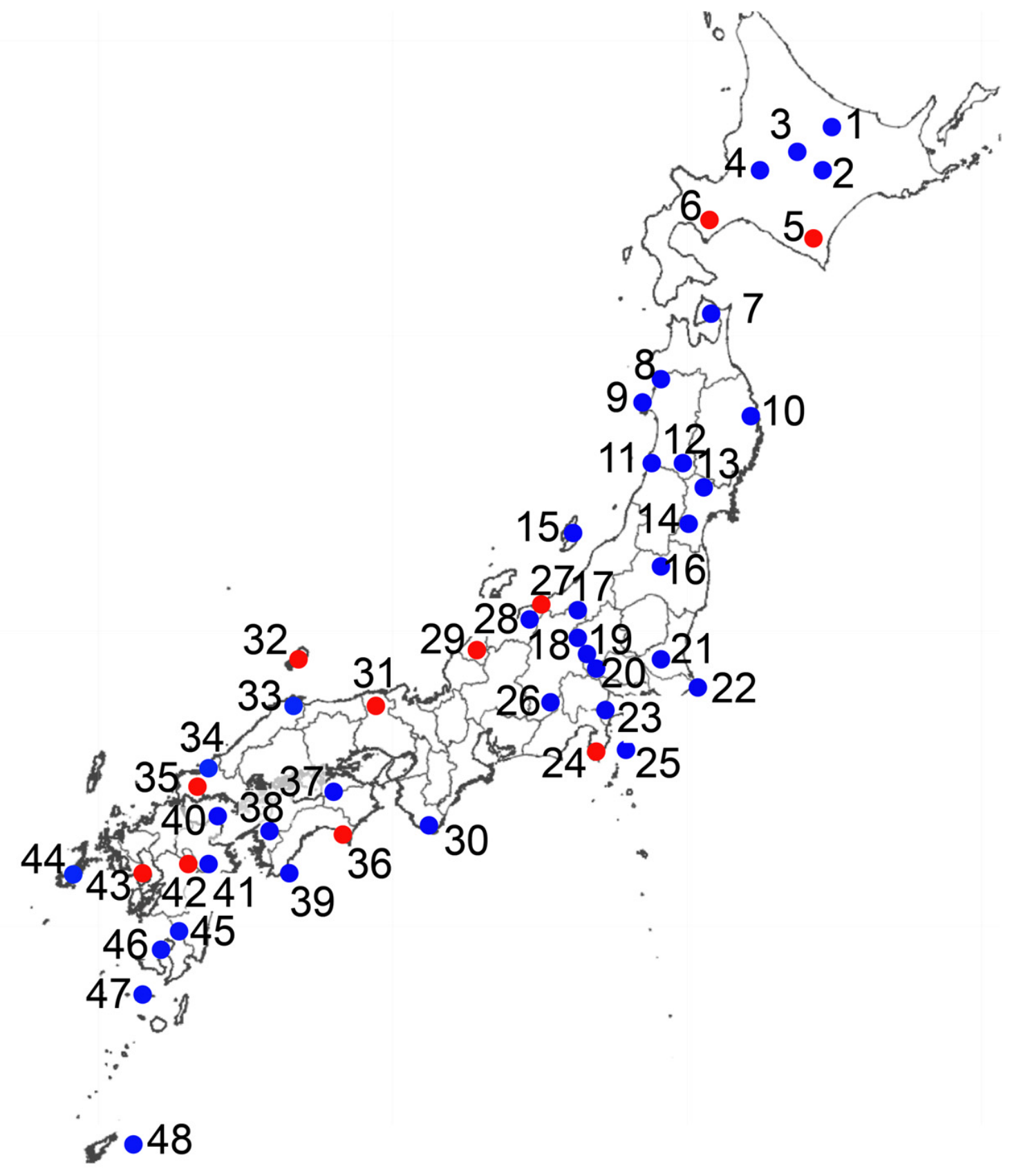
The study encompasses all 48 geoparks of the Japanese Geoparks Network as of April 2026 (Figure 1), including 11 UNESCO Global Geoparks and 37 National Geoparks. Although their designation status differs, all members of the Japanese Geoparks Network are evaluated and managed within a common national framework. The Japanese Geoparks Network promotes activities consistent with the principles and objectives of the UNESCO Global Geoparks programme among both National Geoparks and UNESCO Global Geoparks. Consequently, for the purposes of this study, all 48 geoparks are treated collectively as a single study population.
Figure 1. Locations of Geoparks in Japan (after [25]). Red circles indicate UNESCO Global Geoparks, while blue circles represent Japanese National Geoparks. The numbered geoparks correspond to those listed in Table 1, together with their geological characteristics and representative geoheritage.
Geosciences 16 00283 g001
Table 1. Major geoheritage and representative geological processes in Japanese geoparks. Geopark numbers correspond to those in Figure 1.
Name of GeoparkMajor GeoheritageGeological Context
1Shirataki GeoparkQuaternary ObsidianArc Volcanism
2Tokachi Shikaoi GeoparkActive VolcanoArc Volcanism
3Tokachidake GeoparkActive VolcanoArc Volcanism
4Mikasa GeoparkCretaceous-Paleogene DepositsForearc Sedimentation
5Mt. Apoi GeoparkPaleogene PeridotiteArc–arc Collision
6Toya-Usu GeoparkActive VolcanoArc Volcanism
7Shimokita GeoparkQuaternary VolcanoArc Volcanism
8Happo-Shirakami GeoparkNeogene Green TuffBack-arc Rifting
9Oga Peninsula-Ogata GeoparkNeogene Green TuffBack-arc Rifting
10Sanriku GeoparkPaleozoic-Mesozoic FormationsGondwana Origin
11Mt.Chokai & Tobishima Island GeoparkActive VolcanoArc Volcanism
12Yuzawa GeoparkPliocene Silver DepositsArc Volcanism
13Mt.Kurikoma Area GeoparkActive VolcanoArc Volcanism
14Zao GeoparkActive VolcanoArc Volcanism
15Sado Island GeoparkMiocene Gold DepositsBack-arc Rifting
16Bandaisan GeoparkActive VolcanoArc Volcanism
17Naeba-Sanroku GeoparkQuaternary VolcanoArc Volcanism
18Mt.Asama North GeoparkActive VolcanoArc Volcanism
19Shimonita GeoparkActive VolcanoArc Volcanism
20Chichibu GeoparkJurassic Accretionary ComplexOPS Accretion
21Mt.Tsukuba Area GeoparkPaleogene PlutonArc Volcanism
22Choshi GeoparkCretaceous DepositsForearc Sedimentation
23Hakone GeoparkActive VolcanoArc Volcanism
24Izu Peninsula GeoparkActive VolcanoArc–arc Collision
25Izu Oshima GeoparkActive VolcanoArc Volcanism
26Minami-Alps (MTL Area) GeoparkMedian Tectonic LineMajor Faulting
27Itoigawa GeoparkItoigawa–Shizuoka Tectonic LineArc–arc Collision
28Tateyama Kurobe GeoparkActive VolcanoArc Volcanism
29Hakusan Tedorigawa GeoparkRiver and GorgeWater Circulation
30Nanki Kumano GeoparkMiocene Forearc PlutonForearc Magmatism
31San’in Kaigan GeoparkEarly Pleistocene Columnar BasaltBack-arc Rifting
32Oki Islands GeoparkPaleoproterozoic RocksRodinia Origin
33Shimane Peninsula and Shinjiko Nakaumi Estuary GeoparkLakes and WetlandsLagoon Development
34Hagi GeoparkCretaceous–Quaternary Igneous RocksArc Magmatism
35Miné-Akiyoshidai Karst Plateau GeoparkCarboniferous–Permian Limestone KarstOPS Accretion
36Muroto GeoparkPaleogene Accretionary ComplexSediment Accretion
37Miyoshi GeoparkMedian Tectonic LineMajor Faulting
38Shikoku Seiyo GeoparkKurosegawa Tectonic BeltGondwana Origin
39Tosashimizu GeoparkMiocene Forearc PlutonForearc Magmatism
40Oita Himeshima GeoparkQuaternary VolcanoArc Volcanism
41Oita Bungoono GeoparkLate Pleistocene Pyroclastic DepositsArc Volcanism
42Aso GeoparkActive Volcano with a Large CalderaArc Volcanism
43Unzen Volcanic Area GeoparkActive VolcanoArc Volcanism
44Goto Islands (Shimogoto Area) GeoparkMiocene Sedimentary and Volcanic RocksBack-arc Rifting
45Kirishima GeoparkActive VolcanoArc Volcanism
46Sakurajima-Kinkowan GeoparkActive VolcanoArc Volcanism
47Mishima Village Kikai Caldera GeoparkActive VolcanoArc Volcanism
48Kikaijima GeoparkHolocene Uplifted Coral ReefReef Development

2.1.2. Rationale for Site Selection

The Japanese archipelago provides an exceptional region for examining relationships between Earth-system processes and human society because it has maintained an active-margin setting for approximately 500 million years. Magmatism, tectonism, accretion, geomorphology, hydrology, and crustal maturation associated with long-term oceanic plate subduction have produced diverse geological records that are essential for understanding active-margin processes and orogenic belts worldwide. At the same time, these processes continue to influence contemporary society through earthquakes, volcanic eruptions, steep landscapes, water systems, ecosystems, and regional livelihoods. For this reason, examining all 48 Japanese geoparks within a common national framework provides a suitable basis for investigating how Earth-system processes are expressed in an active-margin setting through geoheritage, geohazards, environmental conditions, and local community practices.

2.1.3. Case Study Sites

In addition to the nationwide analysis of the 48 geoparks, this study uses the Miné-Akiyoshidai Karst Plateau Geopark and the Hagi Geopark [24] as case studies to examine how relationships among geoheritage, human life, and local communities are translated into practical geopark activities. The case studies presented in this study are based on publicly available sources, including official geopark websites [26,27], action plans [28], activity reports, and related documents, together with the author’s long-term observations of geopark activities through service as a strategic advisor to both geoparks.

2.2. Methods

Geological data were derived from 1:50,000 and 1:200,000 geological maps and the Seamless Digital Geological Map of Japan [29], using web-based services provided by the Geological Survey of Japan, AIST. Topographic data were obtained from web-based map services provided by the Geospatial Information Authority of Japan [30] via its web-based map services. Data regarding geoheritage and the geopark activities were gathered from the official websites of the Japanese Geoparks Network [31], the Japan Geopark Committee, and individual geopark organizations. For the Miné-Akiyoshidai Karst Plateau Geopark and the Hagi Geopark, additional resources were used, including master plans, action plans, application and revalidation documents, activity records of geoguides and local residents, and information obtained through interviews. Together, these datasets provided the basis for the nationwide analyses and case studies presented in this study.

3. Results

3.1. Geoheritage in Japanese Geoparks: Records of Active-Margin Evolution

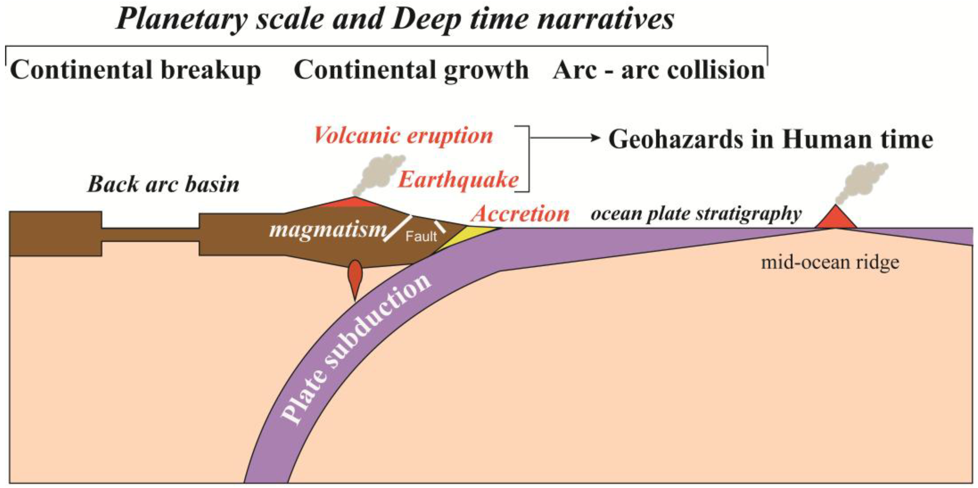
The geological framework of the present Japanese Islands has developed along the active margin of eastern Asia since the Paleo-Pacific Plate began subducting beneath the South China Block approximately 500 million years ago [32,33,34]. As a result, much of the geoheritage preserved within Japanese geoparks records geological processes associated with long-term plate subduction and active-margin evolution. Table 1 summarizes the principal categories of geoheritage representing these processes, while Figure 2 illustrates their relationships within the active-margin Earth system. The figure highlights how plate subduction drives a series of interconnected processes, including accretion, magmatism, continental growth, arc–arc collision, earthquakes, and volcanic eruptions. Rather than representing isolated geological phenomena, these processes together characterize the long-term evolution of an active-margin system and form the geological framework of Japanese geoparks.
The geoheritage preserved in Japanese geoparks collectively records major stages in the evolution of the Japanese active margin (Table 1). One of the most fundamental processes is the accretion of oceanic materials along the trench. Permian, Jurassic, and Cretaceous–Paleogene accretionary complexes are widely distributed throughout Japan and constitute a major component of its geological framework (Table 1; [33,34]). These complexes preserve ocean plate stratigraphy (OPS), mélanges, and trench-fill sediments that document the long-term incorporation of oceanic crust into continental margins [35,36,37]. They also provide important evidence that the Japanese Islands have developed through repeated episodes of oceanic plate subduction and accretion over geological time.
Another major component of the geoheritage preserved in Japanese geoparks is arc magmatism. During the Cretaceous and Paleogene, widespread igneous activity occurred throughout the Japanese Islands in response to accelerated plate convergence and subduction-related magmatism [38,39,40]. This represents the most extensive magmatic episode preserved in Japan and is recorded by numerous geoheritage sites associated with granitic plutons, volcanic complexes, and related igneous rocks (Table 1). These igneous rocks document an important stage of continental growth along the active margin.
An additional tectonic transition occurred during the Miocene. This was marked by widespread back-arc basin development around the Japanese Islands. As a result, extensive volcanism, sedimentary basin development, and crustal extension occurred throughout the archipelago. The volcanic and sedimentary successions formed within these basins, known in Japan as the “Green Tuff”, are preserved in numerous geoparks and record this period of intense volcanism, sedimentation, and crustal extension between approximately 20 and 15 Ma. This tectonic reorganization transformed the Japanese Islands from part of the continental margin of East Asia into the island-arc system observed today. At the same time, it also gave rise to multiple arc–arc collisions around Japan. The collision of the Izu–Bonin Arc with the Honshu Arc and that of the Kuril Arc with northeastern Japan began during this period and remain among the principal tectonic processes shaping the Japanese Islands today [41,42,43,44,45,46].
The active-margin system remains highly dynamic today. During the Quaternary, the Pacific Plate and Philippine Sea Plate have continued to subduct beneath the Japanese Islands, driving frequent earthquakes, active faulting, and arc volcanism. Over geological time, these continuing tectonic and volcanic processes have also produced abundant geoheritage that records Quaternary active-margin evolution. More than half of Japanese geoparks contain active volcanoes or other geoheritage associated with Quaternary volcanic activity, providing opportunities to observe evidence of these active-margin tectonic processes. At the same time, because the same tectonic processes remain active, they continue to generate earthquakes, volcanic eruptions, and other geohazards. The Japanese active margin therefore illustrates how the same active-margin tectonic processes create geoheritage over geological time while continuing to generate geohazards today.
The geoheritage preserved throughout Japanese geoparks records nearly all major tectonic processes associated with active-margin evolution over the past 500 million years, including oceanic plate accretion, continental growth through magmatism, back-arc basin development, arc–arc collision, and ongoing volcanism and seismicity. These same active-margin tectonic processes continue to generate both geoheritage and geohazards today.

3.2. Geohazards in the Japanese Archipelago: Seismicity and Volcanism

Today, the Pacific Plate and Philippine Sea Plate continue to subduct beneath the Japanese Islands, producing frequent seismic activity, arc volcanism, and active faulting. Although Japan accounts for only approximately 0.25% of the Earth’s total land area, it experiences about 20% of the world’s earthquakes with a magnitude of 6.0 or greater [47]. At the same time, despite its limited land area, Japan hosts 111 active volcanoes, representing approximately 10% of the global total [48]. Active faults are also widely distributed across the archipelago and occur within more than half of Japanese geoparks [49].
Major seismic disasters in Japan are summarized in Table 2. They are broadly classified into plate boundary earthquakes, which occur along subduction zones and may generate large tsunamis, and inland crustal earthquakes, which are generally shallower but can cause severe localized damage despite their smaller magnitude [50]. Representative examples of both earthquake types, together with their associated geoparks, are listed in Table 2. Among them, the 2011 off the Pacific coast of Tohoku Earthquake was the most devastating recent plate boundary earthquake, generating a catastrophic tsunami that caused extensive damage along the Pacific coast of northeastern Japan, including the Sanriku Geopark [51,52,53,54,55,56]. Seismic activity along the Japan Trench continues today, as demonstrated by the magnitude 7.7 earthquake of 20 April 2026, which generated small tsunamis along the coasts of the Sanriku, Shimokita, and Mt. Apoi Geoparks [57].
Inland crustal earthquakes are generated by the rupture of active faults within the crust as strain accumulates under the compressional stress field produced by ongoing plate subduction. Because their focal depths are generally shallow, commonly less than 20 km, they can cause severe localized damage near the fault zone [59,60]. Representative examples are summarized in Table 2, including the 2016 Kumamoto Earthquake near the Aso Geopark and the 2008 Iwate–Miyagi Nairiku Earthquake in the Mt.Kurikoma Area Geopark region [61,62,63,64,65]. In addition, major tectonic lines such as the Median Tectonic Line in the Miyoshi and Minami-Alps (MTL Area) Geoparks and the Itoigawa–Shizuoka Tectonic Line in the Itoigawa Geopark are associated with active fault systems capable of generating damaging earthquakes [66,67].
Volcanic disasters associated with Japanese geoparks are summarized in Table 3. Since the 18th century, Japan has experienced 21 volcanic disasters resulting in 10 or more fatalities or missing persons [68]. Representative examples illustrate the diversity of volcanic hazards. The 1926 eruption of Mt. Tokachi generated a snowmelt-induced lahar that caused severe damage in the Tokachidake Geopark and surrounding areas [69,70]. In the Unzen Volcanic Area Geopark, the 1991 collapse of a growing lava dome generated devastating pyroclastic flows [71,72]. Outside geopark regions, the 2014 eruption of Mt. Ontake demonstrated the danger of sudden phreatic eruptions with few recognizable precursory signs, resulting in numerous casualties among hikers [73].
Not all eruptions develop into major disasters. In the Sakurajima-Kinkowan Geopark, Mt. Sakurajima erupted 361 times in 2025, causing only minor agricultural damage [74]. Similarly, the 2000 eruption of Mt. Usu in the Toya-Usu Geopark caused no direct human casualties but damaged roads, railways, and other infrastructure [75]. Mt. Aso in the Aso Geopark also remains active. Its 2021 eruption generated pyroclastic flows extending approximately 1 km from the crater and an eruption column reaching 3500 m above the crater rim [76]. Although recent eruptions have caused limited direct damage, the volcano has experienced repeated caldera-forming eruptions in the past [77].
Table 2 and Table 3 summarize representative earthquakes and volcanic disasters associated with Japanese geoparks. These events are generated by the same tectonic and magmatic processes responsible for the geoheritage summarized in Table 1.

3.3. Hydrological Systems in Japanese Geoparks: Water Circulation in Active-Margin Environments

Japanese active-margin environments generate diverse hydrological systems through the combined influence of tectonic uplift, volcanic activity, climate, and topography. Steep mountain ranges produce short, rapidly flowing rivers, while abundant precipitation and snow accumulation sustain large volumes of groundwater and surface water throughout the archipelago. Owing to the generally short residence time of groundwater, most Japanese rivers consist of soft water with relatively low concentrations of dissolved minerals [78,79].
Water circulates through a variety of geological environments before returning to rivers and the sea. Depending on geological and climatic conditions, groundwater infiltrates volcanic deposits, flows through karst aquifers, is seasonally stored as snow and ice in high mountains, or emerges as springs and wetlands. Representative hot spring systems associated with Japanese geoparks are summarized in Table 4, while representative Ramsar wetlands are listed in Table 5.
Volcanic regions contain numerous hot springs generated by geothermal circulation associated with Quaternary volcanism. In contrast, many non-volcanic hot springs originate from deep groundwater circulating along active faults and fractured bedrock. Similarly, wetlands develop under diverse geological settings, including volcanic plateaus, floodplains, ria coasts, karst groundwater systems, and coastal lagoons. These examples illustrate the diversity of hydrological environments developed within the Japanese active margin.
Among Japanese geoparks, the Hakusan Tedorigawa Geopark provides a representative example of an integrated hydrological system extending from mountain headwaters to the coastal plain. Snow accumulated on Mt. Hakusan infiltrates volcanic rocks, emerges as springs, sustains the Tedori River (Tedorigawa), and ultimately reaches the Sea of Japan. Along this pathway, water has shaped alluvial fans, terraces, irrigation systems, settlements, agriculture, and regional culture. The geopark interprets these interconnected relationships through a spatial and temporal geostory that links geological, hydrological, ecological, and cultural features across the watershed [17,80,81,82].
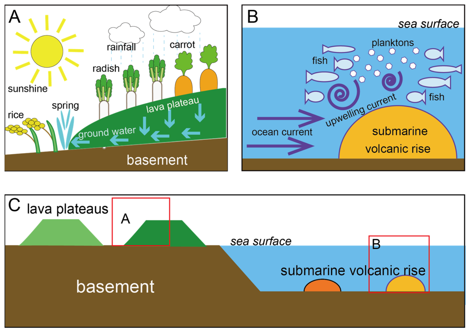
A complementary example is provided by the Hagi Geopark, where groundwater, rivers, springs, and coastal waters illustrate how hydrological systems support everyday human activities. Springs and groundwater have supplied drinking water, agriculture, fisheries, food production, and historical town development, while rivers transport sediment and nutrients from mountainous catchments to coastal ecosystems. Figure 3 summarizes representative examples of these relationships observed within the geopark [83].

3.4. Community-Based Geopark Practice

The preceding section showed how hydrological environments in active-margin settings support agriculture, fisheries, water resources, and other aspects of everyday life. In the Hagi Geopark, particular attention has been given to the relationships between geological and geomorphological features produced by three stages of magmatic activity and contemporary agriculture, fisheries, groundwater resources, and local culture (Figure 3).
Since becoming a Japanese Geopark in 2018, the Hagi Geopark has developed practical activities that connect Earth processes with local livelihoods, culture, and industries. Rather than presenting geoheritage only as scientific knowledge, these activities provide opportunities for local residents to recognize the value of their environment through everyday life.
Several programs connect geological processes with local food production and food culture. At Hagi Sea Mart, visitors learn how submarine volcanic landforms and marine environments contribute to productive fishing grounds and local seafood. In the “Earth-Eating Cafeteria,” participants enjoy dishes prepared by local chefs while learning how local geology, topography, water, and ecosystems support regional agricultural products, livestock, fisheries, and food culture.
Similar approaches have been developed in relation to local culture and education. Hagi ware, a ceramic tradition with a history of more than 400 years, developed through the use of local geological materials, including weathered granitic soils and volcanic-derived clay resources. Geopark programs introduce the relationships among local geology, clay resources, ceramic production, and regional culture, including the use of traditional climbing kilns. The geopark has also worked with local schools to restore the cultivation of indigo plants once used for traditional dyeing in the Hagi region. Through this long-term geoeducation program, successive generations of schoolchildren learn how local topography, soils, and environmental conditions supported indigo cultivation while contributing to the revival of a regional cultural tradition.
Community participation has also extended to geoheritage conservation. Following rainfall-induced damage to a geosite, local residents requested restoration work. They subsequently learned simple monitoring techniques from a geologist and have continued to monitor crack widths in the unstable slope by taking turns measuring them with rulers. This activity connects expert geological knowledge with community-based conservation and monitoring practices.
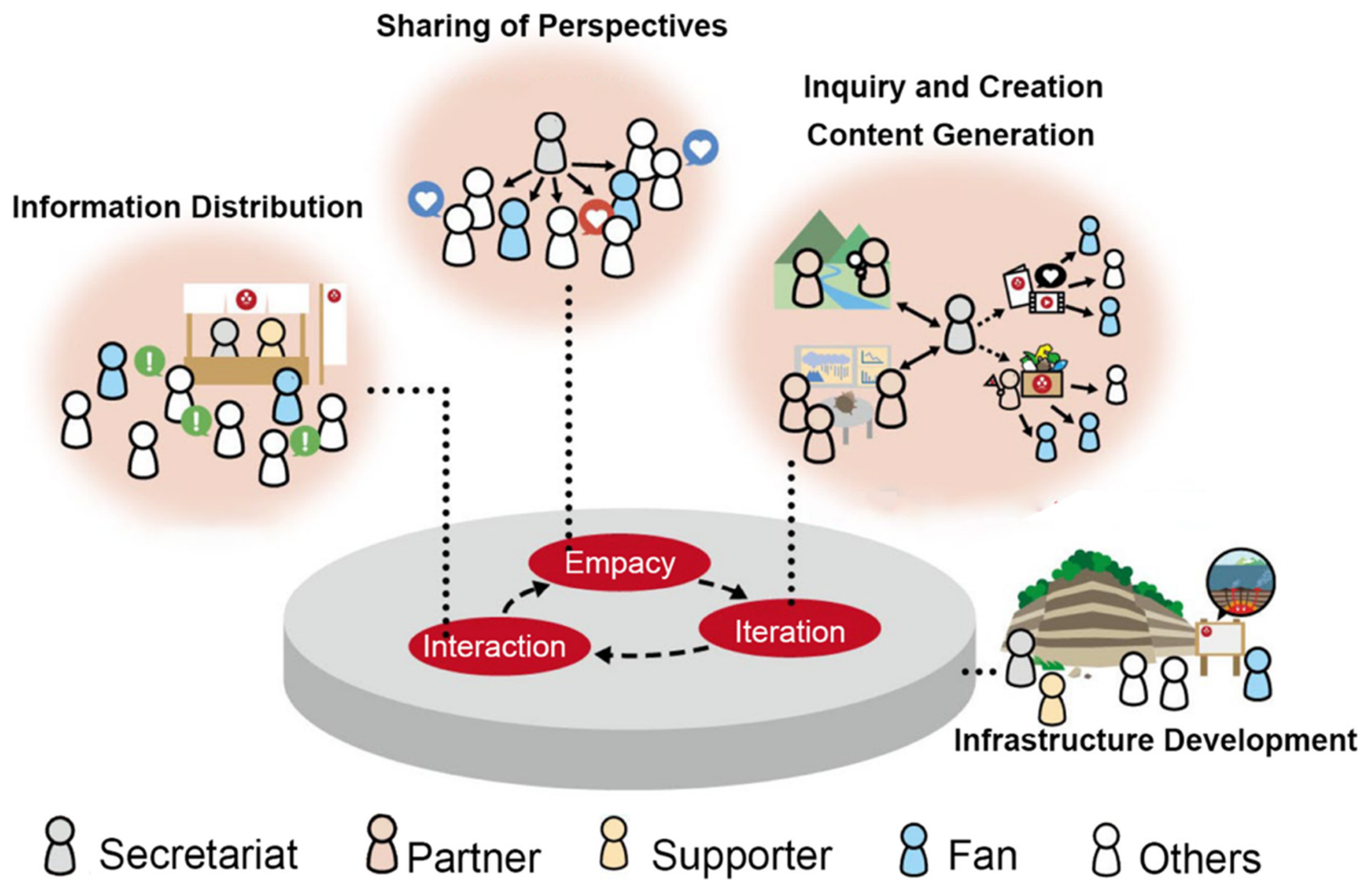
After eight years of practical activities connecting Earth processes with local livelihoods, culture, and industries, the Hagi Geopark developed the Action Plan (2026–2029) [28]. Building on these accumulated experiences, the plan presents a framework designed to encourage greater resident-led participation (Figure 4). The framework positions the secretariat as a hub connecting residents, practitioners, researchers, businesses, schools, and community organizations. It also provides multiple pathways for participation and organizes activities through five core measures.

4. Discussion

4.1. Networking Geoheritage Through Deep Time and Earth-System Processes

As presented in Section 3.1, the geoheritage sites distributed across Japanese geoparks preserve diverse geological records associated with the long-term evolution of the Japanese active margin. Although each site possesses its own local geological significance, these geoheritages can also be interpreted as interconnected records of Earth-system processes operating across multiple spatial and temporal scales.
The Japanese archipelago preserves a wide range of tectonic processes related to oceanic plate subduction, including arc magmatism, accretion, arc–arc collision, back-arc rifting, crustal uplift, and erosion [33]. Geoheritage associated with these processes is distributed throughout Japanese geoparks. For example, the Izu-Bonin Arc preserves ongoing processes related to continental crust formation [41,42,84], while accretionary complexes record the recycling of oceanic materials within plate tectonic systems [33,35,36,37]. Similarly, arc-collision zones preserved in the Izu Peninsula Geopark and Mt. Apoi Geopark provide insights into long-term continental growth processes [41,42,43,44,45,46]. Collectively, these geoheritages represent not simply isolated geological phenomena, but interconnected expressions of active-margin Earth-system evolution extending from Deep Time to the present.
Another example is provided by the geoheritage associated with the opening of the Sea of Japan. Miocene volcanic rocks and sedimentary basins distributed throughout Japan record crustal extension, subsidence, and magmatic activity associated with back-arc opening [85]. These records preserve evidence of continental-margin rifting processes that have repeatedly occurred throughout Earth history. Local geoheritage can be interpreted as part of broader tectonic cycles involving continental growth, fragmentation, and reorganization, reinforcing the Earth-system perspective presented in Section 3.1.
This broader interpretation expands the significance of geoheritage beyond local geological descriptions. Individual geosites become components of larger tectonic systems that have continuously shaped the Earth throughout geological history. This perspective allows local geoheritage to be repositioned within broader Earth-system processes and Deep Time.
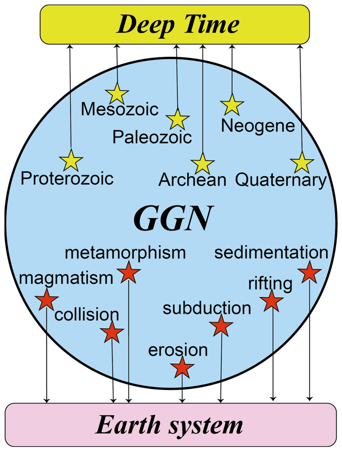
The same perspective can be extended beyond Japan. The UNESCO Global Geoparks preserve geoheritage representing diverse geological ages and Earth-system processes, including continental rifting, subduction, collision, sedimentation, magmatism, metamorphism, and erosion (e.g., [86,87]). As illustrated in Figure 5, geoheritage preserved in UNESCO Global Geoparks can be interpreted as complementary records of planetary-scale Earth-system processes operating across Deep Time.
Viewed individually, each geopark preserves geoheritage with its own scientific, educational, cultural, and regional significance as a valuable heritage to be conserved for future generations [3,4,5,6,7,8,9,10,12,13,14,19,20,21,22]. However, when connected through the UNESCO Global Geopark Network, these sites also create opportunities to recognize broader relationships among geological processes operating across the Earth system. Through such connections, local geoheritage can be interpreted within a much larger framework extending from the Archean to the present and ultimately into the future.
This perspective is particularly meaningful for Japanese geoparks. Precambrian geological records are extremely limited in Japan because active-margin processes have repeatedly removed, fragmented, or overprinted older geological units through subduction, accretion, tectonic erosion, magmatism, deformation, and uplift [88,89]. Most large-scale geoheritage preserved in Japan is younger than approximately 300 million years. In contrast, the UNESCO Global Geopark Network encompasses geoheritage representing a far broader range of Earth history, from the Archean to the present [90,91]. Through this global network, Japanese geoparks can be connected to geoheritage representing earlier stages of planetary evolution, thereby extending perspectives beyond the active-margin history of Japan toward Earth-system evolution across Deep Time.
An illustrative example is provided by the Miné-Akiyoshidai Karst Plateau Geopark. Geo-guides often ask visitors standing on the karst plateau how many limestone rocks they believe are exposed before explaining that the entire landscape is actually part of a single massive limestone body connected underground. Although individual pinnacles appear isolated at the surface, they are components of a larger geological structure. In a similar way, geoheritage sites distributed across geoparks worldwide may also be interpreted as interconnected expressions of broader Earth-system processes, even when they appear geographically separated.
By networking geoheritage through the framework of UNESCO Global Geoparks, local landscapes can be connected to planetary-scale Earth-system processes and Deep Time. Such expanded perspectives enable people to recognize that familiar landscapes and geoheritage are part of much larger geological processes operating across the Earth system. However, the purpose of these broader perspectives is not simply to extend understanding toward global scales. Equally important is the return of these perspectives to local communities, where they can provide new ways of interpreting the significance of local landscapes, natural resources, environmental conditions, and geohazards.
In this sense, geoparks function not only as places where perspectives expand from local environments toward planetary-scale Earth-system processes, but also as places where these broader understandings reconnect with everyday life. Through repeated movement between local and global perspectives, people may reinterpret familiar landscapes within the broader context of Earth history while grounding Earth-system understanding in lived experience. The present interpretation also resonates with recent discussions emphasizing that geoparks communicate geoheritage through broader meta-narratives linking geological processes with planetary and societal perspectives (e.g., [92]).

4.2. Geohazards on Active Margins: The Temporal Gap Between Human Time and Deep Time

The Japanese archipelago is situated on an active margin, where earthquakes and volcanic eruptions occur repeatedly as consequences of ongoing plate subduction. Because the Japanese Islands have remained along convergent plate boundaries for approximately 500 million years, similar tectonic and magmatic processes have operated throughout Deep Time. From this perspective, earthquakes and volcanic eruptions may be interpreted not merely as contemporary disasters, but as recurrent geological processes characteristic of active margins.
Geological and historical records indicate that large earthquakes, tsunamis, and volcanic eruptions have repeatedly affected the Japanese archipelago throughout geological time. Recurrence intervals estimated by the Headquarters for Earthquake Research Promotion (HERP) suggest that M9-class earthquakes occur at intervals of approximately 550–600 years, M8-class earthquakes at approximately 109 years, and M7-class earthquakes at intervals of 12–15 years [93]. Geological evidence, including tsunami deposits, trench turbidites, accretionary complexes, and volcanic deposits preserved in Japanese geoparks, further demonstrates that earthquakes, tsunamis, volcanic eruptions, and crustal deformation have repeatedly occurred throughout Deep Time [33,94,95]. These records indicate that geohazards and geoheritage are not independent phenomena, but different expressions of the same tectonic and magmatic processes operating within active margins.
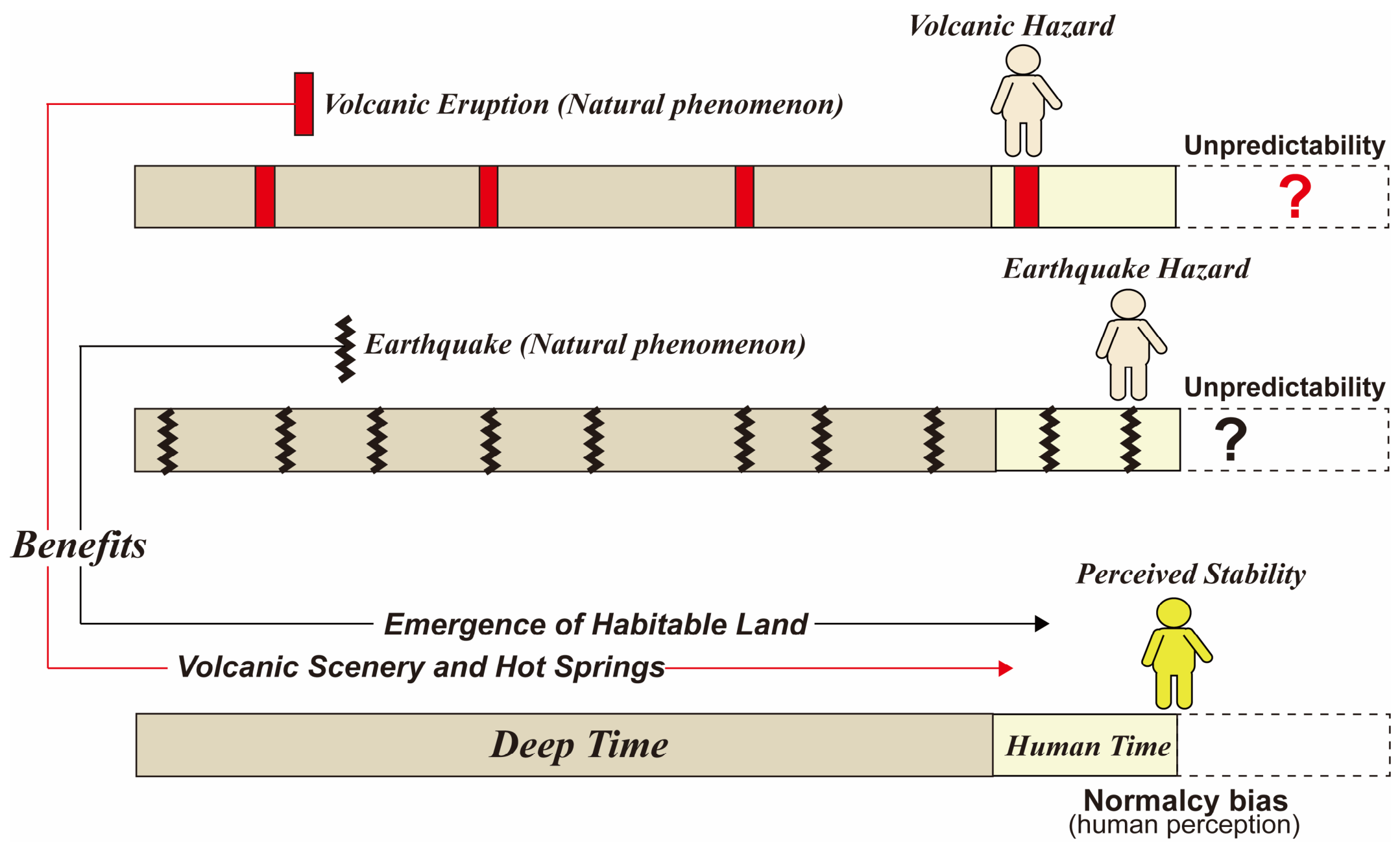
However, the recurrence intervals of the most destructive geohazards are often considerably longer than ordinary human memory, community experience, or administrative planning cycles. Consequently, although active-margin processes operate continuously over geological timescales, their most destructive manifestations are commonly experienced within Human Time as infrequent and exceptional events. This discrepancy creates a temporal gap between geological processes and human perception.
This temporal gap is particularly evident along the Japan Trench and the Nankai Trough, where geological and historical records indicate repeated occurrences of giant earthquakes and tsunamis over periods of thousands of years [93,96]. At the same time, current seismology acknowledges that the exact timing, location, and magnitude of future earthquakes cannot be predicted accurately [97]. For residents living in regions such as the Sanriku Geopark, Muroto Geopark, Nanki Kumano Geopark, and Tosashimizu Geopark, future earthquakes and tsunamis therefore remain both inevitable and uncertain aspects of the active-margin environment.
Earthquakes and volcanic eruptions are recurrent geological processes throughout Deep Time, yet they are often perceived within Human Time as rare and unpredictable events. This discrepancy may contribute to normalcy bias, the tendency to assume that destructive events are unlikely to occur within one’s own lifetime or community. While geohazards are experienced intermittently, the environmental benefits generated by active-margin processes—including habitable land, fertile soils, water resources, volcanic scenery, and hot springs—are experienced more continuously in everyday life. As a result, people may gradually perceive active-margin environments as fundamentally stable despite the persistence of underlying geological processes.
As illustrated in Figure 6, destructive geohazards recur repeatedly across Deep Time but are experienced within Human Time as infrequent and unpredictable events, whereas environmental benefits are experienced more continuously. This temporal asymmetry may reinforce perceptions of environmental stability and contribute to normalcy bias.
Human societies have long adapted to living with recurrent geohazards despite this temporal gap. Adaptation has involved not only recovering from disasters after they occur, but also developing practical knowledge, land-use strategies, and cultural traditions that enable communities to live with recurrent geohazards. Following the 1926 eruption of Mt. Tokachi, extensive farmland was buried by volcanic deposits, requiring decades of soil improvement and land restoration before agricultural productivity could recover [98,99]. These examples demonstrate that many benefits associated with active-margin environments have been maintained through continuous human adaptation and recovery efforts in response to repeated geological disturbances.
In addition to physical adaptation, communities have developed cultural mechanisms for preserving memories of rare but destructive events across generations. In the Sanriku Geopark, the traditional teaching of “Tsunami Tendenko” has been incorporated into disaster education and contributed to successful evacuation during the 2011 Tohoku Earthquake and tsunami [100]. Similarly, the story of “Inamura no Hi” preserves collective memory of the 1854 Ansei-Tokai Earthquake and tsunami through local culture and education [101]. Such practices help bridge the temporal gap between infrequent disasters and everyday experience by transmitting hazard awareness beyond the limits of individual memory.
These examples suggest that, as shown in Section 3.2, active-margin environments are shaped by both recurring geohazards and long-term human adaptation. Although destructive earthquakes and volcanic eruptions may be experienced as infrequent events within Human Time, the geological processes underlying them persist continuously throughout Deep Time. Geoparks provide opportunities to recognize that geohazards and environmental benefits are different expressions of the same active-margin processes.
This perspective extends previous studies that have emphasized the role of geoeducation in disaster risk reduction and hazard awareness (e.g., [102,103]). From this perspective, by recognizing recurrent geohazards within the broader context of Deep Time, geoparks may provide practical settings in which the concept of Timefulness can be experienced through local landscapes and everyday life [104].

4.3. Human Society Embedded in Earth-System Circulation

As discussed in Section 3.3, active-margin environments generate diverse hydrological systems, including rivers, groundwater, springs, wetlands, hot springs, and coastal waters. These environments are not merely water resources. They represent pathways through which geological processes influence ecosystems, agriculture, fisheries, and human society. In this sense, water provides one of the most direct links between Earth-system processes and everyday human life.
Water is indispensable to human life. Approximately 60% of the adult human body consists of water [105], and several liters are exchanged daily through drinking, metabolism, and physiological processes [106]. In many geopark regions, this water originates from groundwater and river systems controlled by local geological and hydrological conditions. Human life is therefore directly connected to the geological environment through hydrological circulation.
The hydrological characteristics of Japan are strongly influenced by active-margin tectonics. Ongoing uplift has produced steep mountains and short, rapidly flowing rivers. Because water residence times are generally short, river water and groundwater often contain relatively low concentrations of dissolved minerals and are commonly characterized as soft water [79]. These hydrological conditions have influenced many aspects of Japanese food culture, including the preparation of rice, tea, and traditional cuisine [78]. In volcanic regions, permeable volcanic deposits store groundwater that later emerges as springs, while karst terrains develop complex groundwater systems through dissolution and underground drainage. Thus, active-margin geological processes influence not only landscapes but also the quantity and quality of water that sustains everyday life.
The Miné-Akiyoshidai Karst Plateau Geopark provides a representative example. At the Beppu Benten area, surface water disappears into limestone through karst conduits and later re-emerges as spring water along a fault zone, supporting rice cultivation on the adjacent alluvial plain [107]. This example illustrates how geological structure, groundwater circulation, agriculture, and community water use are interconnected within a single hydrological system.
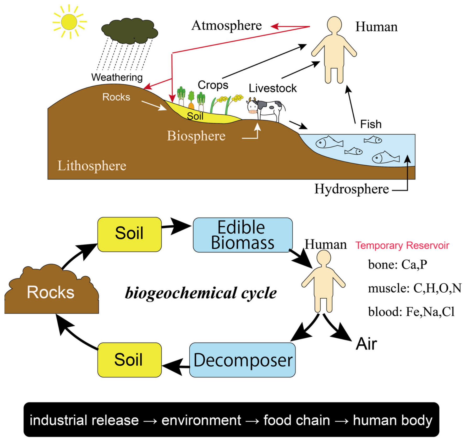
These relationships extend beyond water itself to the circulation of materials throughout the Earth system (Figure 7). Through weathering, minerals derived from rocks are released into soils and water systems, incorporated into crops, livestock, and marine organisms, and eventually consumed by humans [108]. Water, dissolved minerals, nutrients, and organic matter continuously circulate among rocks, soils, ecosystems, living organisms, and the atmosphere. Human society participates directly in these circulation systems through food production, consumption, and daily life.
Because materials circulate continuously through Earth-system pathways, substances introduced by human activities may also propagate through interconnected geological, hydrological, and ecological systems [109]. Historical examples in Japan, including mercury pollution in Minamata [110] and cadmium contamination associated with mining activities [111], demonstrate how disturbances introduced into circulation systems can affect ecosystems and human health over long timescales. These examples illustrate that human activities themselves become incorporated into Earth-system circulation.
These observations indicate that human life is not external to the Earth system but embedded within ongoing circulation linking rocks, water, ecosystems, food production, and society. Geoparks provide opportunities to recognize these relationships by connecting everyday experiences with the broader Earth-system circulation that sustains human life.
This perspective builds upon previous work highlighting the importance of geodiversity, geosystem services, and geoheritage in supporting ecosystems and human well-being (e.g., [3,4,5]). In addition to these perspectives, the present study suggests that geoparks can provide practical settings in which people recognize themselves as participants within the continuous Earth-system circulation linking rocks, water, ecosystems, food production, and human society.

4.4. Geoparks as Spaces for Participation and Community Practice

Many Japanese geoparks are located in active-margin regions characterized by steep mountainous terrain, geographically fragmented settlements, and limited areas of habitable land. At the same time, many of these regions face rapid depopulation, aging populations, and the gradual weakening of local social connections. As increasing numbers of elderly residents live alone or in aging households, challenges related to social isolation, transportation access, disaster vulnerability, and the long-term sustainability of local communities have become increasingly significant.
The 2011 Great East Japan Earthquake and tsunami highlighted the importance of these issues for local communities [56]. In many affected communities, residents were required to make immediate evacuation decisions together with neighbors before official assistance could arrive. Studies of the disaster have shown that communities with strong pre-existing social relationships demonstrated greater resilience during evacuation, shelter life, and long-term recovery processes [112,113,114,115]. These experiences suggest that sustainable local communities depend not only on governmental support and physical infrastructure but also on opportunities for participation, mutual support, and the social relationships that are cultivated through everyday community life.
From this perspective, the practical activities presented in Section 3.4 can be understood as more than individual programs in geoeducation, geotourism, conservation, or regional development. In the Hagi Geopark, activities related to local food culture, Hagi ware, indigo cultivation, and geoheritage conservation all reconnect geological processes with people’s everyday lives. Although these activities differ in their immediate objectives, they all encourage local residents to recognize relationships between the Earth and their communities through active participation in everyday life.
The Hagi Geopark Action Plan (2026–2029) further develops this perspective [28]. Rather than positioning the geopark secretariat as the principal actor, the plan proposes a framework in which local residents participate according to their own interests, abilities, and circumstances as Partners, Supporters, or Fans. The role of the secretariat is to support these diverse forms of community engagement by providing opportunities for learning, collaboration, information sharing, and networking. In this way, the Action Plan represents a practical framework through which relationships between the Earth and human society can be continuously translated into locally initiated activities.
Similar forms of community participation can also be observed in other Japanese geoparks. In the Sanriku Geopark, post-disaster reconstruction initiatives have emphasized neighborhood relationships, local participation, and the transmission of disaster memory. In several other geoparks, including the Hagi Geopark, the Miné-Akiyoshidai Karst Plateau Geopark, and the Kirishima Geopark, universal tourism initiatives encourage elderly residents and people with disabilities to participate more actively in geotourism and community activities [107,116,117]. Although these initiatives differ in their immediate objectives, they share a common emphasis on creating opportunities for communication, participation, and collaboration among diverse members of local communities.
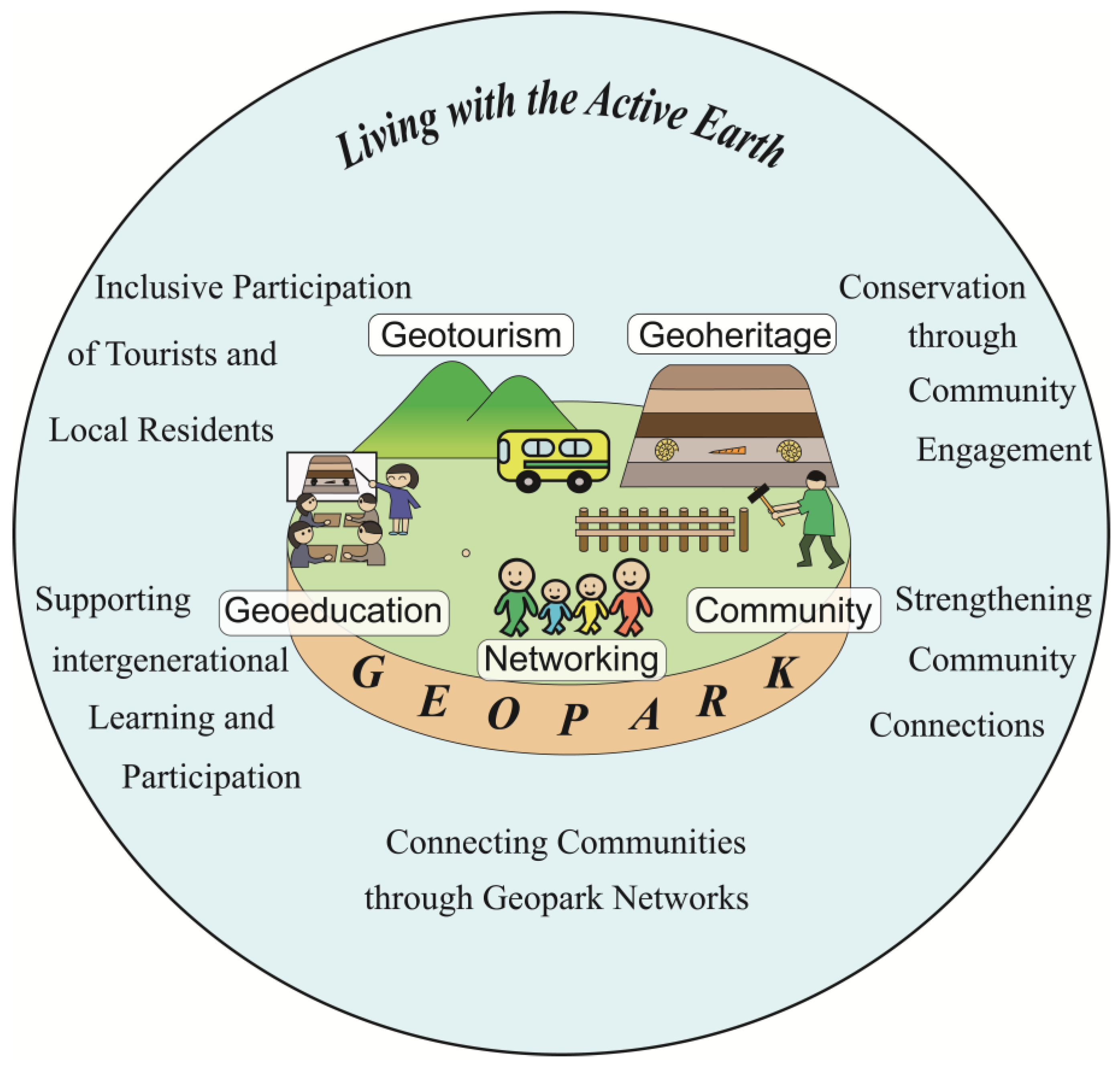
Figure 8 summarizes this perspective. Geoheritage provides a foundation for geoeducation, geotourism, conservation, networking, and diverse community activities. Through participation in these activities, relationships between the Earth and human society are recognized and expressed through local practice. At the same time, these activities strengthen connections among people, local communities, and the Earth system while creating opportunities for mutual learning, care, and cooperation across generations and social groups.
Viewed from this perspective, geoparks are not only places for conserving geoheritage or promoting tourism but also practical spaces where relationships between the Earth and human society are translated into education, culture, conservation, local industries, and community practice. Through these diverse forms of participation, geoparks strengthen connections among people, local communities, and the Earth system while contributing to more resilient local communities in active-margin regions.
This interpretation also complements previous studies emphasizing community engagement and participatory approaches in geoparks (e.g., [17,118,119]). The present study further suggests that participation is not only a means of supporting geopark activities but also a continuous process through which relationships among people, local communities, and the Earth system are continually reconnected through everyday practice.

5. Conclusions

This study examined Japanese geoparks situated within one of the world’s most tectonically active regions through four interconnected perspectives: geoheritage, geohazards, Earth-system circulation, and local communities. Based on a comprehensive examination of all 48 members of the Japanese Geoparks Network, together with practical observations from the Hagi Geopark and the Miné-Akiyoshidai Karst Plateau Geopark, the study explored how active-margin Earth-system processes are expressed through geoheritage, environmental conditions, and human society.
The results demonstrate that Japanese geoparks collectively preserve diverse records of plate subduction, magmatism, accretion, crustal deformation, uplift, erosion, sedimentation, and hydrological processes that have shaped the Japanese archipelago throughout Deep Time. At the same time, these processes continue to influence contemporary society through earthquakes, volcanic eruptions, water resources, ecosystems, agriculture, fisheries, and regional landscapes. From this perspective, geoheritage, geohazards, and hydrological environments may be understood not as separate phenomena, but as different expressions of Earth-system processes operating across different temporal and spatial scales.
A central contribution of this study is the identification of four forms of reconnection through which geoparks may help bridge relationships that are often separated in everyday human experience. First, geoheritage can reconnect local landscapes with Deep Time by revealing how individual geosites represent long-term Earth-system processes. Second, geohazards can reconnect Human Time with Deep Time by demonstrating that earthquakes, tsunamis, and volcanic eruptions are recurrent geological processes rather than isolated disasters. Third, water environments and Earth-system circulation can reconnect human life with ongoing geological and ecological processes by illustrating how water, food production, ecosystems, and livelihoods are sustained through interconnected material cycles. Finally, geopark activities can reconnect people with local communities through participation, communication, intergenerational learning, and shared engagement with regional environments.
Overall, these findings suggest that geoparks can be regarded not only as places for conserving geoheritage or promoting tourism, but also as practical frameworks for reconnecting relationships among the Earth system, time, place, and human society. Rather than treating geoheritage, geohazards, water environments, and community activities as separate domains, the present study demonstrates that they collectively represent complementary expressions of active-margin Earth-system processes operating across multiple spatial and temporal scales.
Participation provides the practical foundation for these reconnections. Through geoeducation, geotourism, geoheritage conservation, disaster learning, universal tourism, and community activities, geoparks create opportunities for people to recognize relationships between local environments and broader Earth-system processes. In this way, participation functions not merely as a means of communication but also as a process through which relationships among people, communities, and the Earth system can be continuously strengthened and renewed.
By interpreting the Japanese Geoparks Network as an integrated active-margin Earth system rather than simply as a collection of individual geoparks, this study provides a complementary perspective for geopark research. It demonstrates how geological information, geohazards, hydrological environments, Earth-system circulation, and community-based practices can be integrated within a single conceptual framework. This interpretation also complements previous geopark research by emphasizing not only the characteristics of individual geoparks but also their collective significance for understanding long-term relationships between the dynamic Earth system and human society.

Funding

This research was supported by JSPS KAKENHI Grant Number, JP23H03645.

Data Availability Statement

The data presented in this study were compiled from publicly available sources cited in the manuscript. No new primary data were generated. Therefore, no additional datasets are available.

Acknowledgments

The author is grateful to Takaaki Shirai of the Hagi Geopark Promotion Council Secretariat for providing detailed explanations of the guiding principles of Hagi Geopark. The author also sincerely thanks Joanna Wilson of the Miné–Akiyoshidai Karst Plateau Geopark for her candid and constructive comments on an earlier draft of the manuscript. These contributions are gratefully acknowledged.

Conflicts of Interest

The author declares no conflicts of interest.

References

  1. Nyulas, J.; Dezsi, Ș.; Niță, A.-F.; Magyari-Sáska, Z.; Frey, M.-L.; Horváth, A. Twenty-Five Years of Scientific Production on Geoparks from the Perspective of Bibliometric Analysis Using PRISMA. Sustainability 2025, 17, 2218. [Google Scholar] [CrossRef] [Scilit]
  2. Herrera-Franco, G.; Montalván-Burbano, N.; Carrión-Mero, P.; Jaya-Montalvo, M.; Gurumendi-Noriega, M. Worldwide Research on Geoparks through Bibliometric Analysis. Sustainability 2021, 13, 1175. [Google Scholar] [CrossRef] [Scilit]
  3. Gordon, J.E. Geoheritage, Geotourism and the Cultural Landscape: Enhancing the Visitor Experience and Promoting Geoconservation. Geoheritage 2018, 8, 136. [Google Scholar] [CrossRef] [Scilit]
  4. Gray, M. Geodiversity—Valuing and Conserving Abiotic Nature; John Wiley & Sons, Ltd.: Hoboken, NJ, USA, 2013. [Google Scholar]
  5. Brilha, J. Inventory and Quantitative Assessment of Geosites and Geodiversity Sites: A Review. Geoheritage 2016, 8, 119–134. [Google Scholar] [CrossRef] [Scilit]
  6. Henriques, M.H.; Dos Reis, R.P.; Brilha, J.; Mota, T. Geoconservation as an Emerging Geoscience. Geoheritage 2011, 3, 117–128. [Google Scholar] [CrossRef] [Scilit]
  7. Farsani, N.T.; Coelho, C.; Costa, C. Geotourism and Geoparks as Novel Strategies for Socio-Economic Development in Rural Areas. Int. J. Tour. Res. 2011, 13, 68–81. [Google Scholar] [CrossRef] [Scilit]
  8. Dowling, R.K.; Newsome, D. Handbook of Geotourism; Edward Elgar: Cheltenham, UK, 2018. [Google Scholar]
  9. Newsome, D.; Dowling, R. Geotourism; Goodfellow Publishers: Oxford, UK, 2010. [Google Scholar]
  10. Hose, T.A. Towards a History of Geotourism: Definitions, Antecedents and the Future. In History of Geoconservation; Birel, C.V., Prosser, C.D., Eds.; Special Publications; Geological Society: London, UK, 2008; Volume 300, pp. 37–60. [Google Scholar] [CrossRef] [Scilit]
  11. Martínez-Martín, J.E.; Mariñoso, P.E.; Rosado-González, E.M.; Sá, A.A. UNESCO Global Geoparks vs. Education: A 10-Year Bibliometric Analysis. Geoheritage 2023, 15, 34. [Google Scholar] [CrossRef] [Scilit]
  12. Ferdowsi, S.; Tavana, M.; Heydari, R.; Štrba, Ľ. Geoeducation: The Key to Geoheritage Conservation in Tourism Destinations. Int. Geol. Rev. 2025, 67, 1674–1696. [Google Scholar] [CrossRef] [Scilit]
  13. Zafeiropoulos, G.; Drinia, H.; Antonarakou, A.; Zouros, N. From Geoheritage to Geoeducation, Geoethics and Geotourism: A Critical Evaluation of the Greek Region. Geosciences 2021, 11, 381. [Google Scholar] [CrossRef] [Scilit]
  14. Yaakob, M.F.M. Managing Geo-Education within Education for Sustainable Development. Discov. Sustain. 2026, 7, 1010. [Google Scholar] [CrossRef] [Scilit]
  15. Louis, A.A.; Talib, H.; Chan, J.K.L.; Kamlun, K.U. Benefits of Geoparks from the Perspective of Local Communities: A Case Study of Kinabalu UNESCO Global Geopark, Malaysia. Int. J. Geoheritage Parks 2025, 13, 534–546. [Google Scholar] [CrossRef] [Scilit]
  16. Lee, Y.; Jayakumar, R. Economic Impact of UNESCO Global Geoparks on Local Communities: Comparative Analysis of Three UNESCO Global Geoparks in Asia. Int. J. Geoheritage Parks 2021, 9, 189–198. [Google Scholar] [CrossRef] [Scilit]
  17. Mammadova, A.; Redkin, A.; Beketova, T.; Smith, C.D. Community Engagement in UNESCO Biosphere Reserves and Geoparks: Case Studies from Mount Hakusan in Japan and Altai in Russia. Land 2022, 11, 227. [Google Scholar] [CrossRef] [Scilit]
  18. Dousin, O.; Aralas, S.; Denis, J.I. Geopark Development and Community Well-Being: The Case of Kinabalu UNESCO Global Geopark, Sabah, Malaysian Borneo. Int. J. Geoheritage Parks 2024, 12, 384–395. [Google Scholar] [CrossRef] [Scilit]
  19. Koupatsiaris, A.A.; Drinia, H. Geoethics as a Normative Foundation for Geoheritage, Geoconservation, and Geoeducation: From Geological Value toward Moral Responsibility. J. Geoethics Soc. Geosci. 2026, 1, 1–34. [Google Scholar] [CrossRef] [Scilit]
  20. Peppoloni, S.; Di Capua, G. Current Definition and Vision of Geoethics. In Geo-Societal Narratives; Bohle, M., Marone, E., Eds.; Springer: Cham, Switzerland, 2021. [Google Scholar]
  21. Di Capua, G.; Bobrowsky, P.T.; Kieffer, S.W.; Palinkas, C. Introduction: Geoethics Goes beyond the Geoscience Profession. Geol. Soc. Lond. Spec. Publ. 2021, 508, 1–11. [Google Scholar] [CrossRef] [Scilit]
  22. Antić, A.; Buchanan, M.; Bosnić, M.G.; Marjanović, M.; Di Capua, G.; Peppoloni, S.; Marković, S.B.; Spalević, V.; Marković, R.; Tomić, N. Geoethics Supporting Geotourism Modelling: Assessing Karst Geosites and Management Practices in Serbia and Montenegro. Int. J. Geoheritage Parks 2026, 14, 108–126. [Google Scholar] [CrossRef] [Scilit]
  23. Watanabe, M. The Origin and Development of Geoparks in Japan: Reflections from a Personal Perspective. In Natural Heritage of Japan; Chakraborty, A., Mokudai, K., Cooper, M., Watanabe, M., Chakraborty, S., Eds.; Geoheritage, Geoparks and Geotourism; Springer International Publishing: Cham, Switzerland, 2018; pp. 87–94. ISBN 978-3-319-61895-1. [Google Scholar]
  24. Wakita, K. Nature and Geoparks in Yamaguchi. Bull. Yamaguchi Sci. Res. Cent. 2022, 2, 21–47. [Google Scholar]
  25. Japanese Geoparks Network. Geopark Map of Japan; Japanese Geoparks Network: Tokyo, Japan, 2026. [Google Scholar]
  26. Miné-Akiyoshidai Karst Plateau Geopark Planning and Promotion Council. Miné-Akiyoshidai Karst Plateau Official Web Page. Available online: https://mine-geo.com (accessed on 15 May 2026).
  27. Hagi Geopark Planning and Promotion Council. Hagi Geopark. Available online: https://hagi-geopark.jp (accessed on 15 May 2026).
  28. Hagi Geopark Planning and Promotion Council. Hagi Geopark Action Plan 2026–2029; Hagi Geopark Planning and Promotion Council: Hagi City, Japan, 2026; p. 39. [Google Scholar]
  29. Geological Survey of Japan. AIST Seamless Digital Geological Map of Japan V2 1:200,000, Original Edition. Available online: https://gbank.gsj.jp/seamless/ (accessed on 15 May 2026).
  30. The Geospatial Information Authority of Japan GSI Maps. Available online: https://maps.gsi.go.jp/ (accessed on 15 May 2026).
  31. Japanese Geoparks Network. Available online: https://geopark.jp (accessed on 15 May 2026).
  32. Wakita, K. Geology and Tectonics of Japanese Islands: A Review—The Key to Understanding the Geology of Asia. J. Asian Earth Sci. 2013, 72, 75–87. [Google Scholar] [CrossRef] [Scilit]
  33. Wakita, K.; Nakagawa, T.; Sakata, M.; Tanaka, N.; Oyama, N. Phanerozoic Accretionary History of Japan and the Western Pacific Margin. Geol. Mag. 2021, 158, 13–29. [Google Scholar] [CrossRef] [Scilit]
  34. Isozaki, Y.; Maruyama, S.; Aoki, K.; Nakama, T.; Miyashita, A.; Otoh, S. Geotectonic Subdivision of the Japanese Islands Revisited: Categorization and Definition of Elements and Boundaries of Pacific-Type (Miyashiro-Type) Orogen. J. Geogr. 2010, 119, 999–1053. [Google Scholar] [CrossRef] [Scilit]
  35. Wakita, K. OPS Mélange: A New Term for Mélanges of Convergent Margins of the World. Int. Geol. Rev. 2015, 57, 529–539. [Google Scholar] [CrossRef] [Scilit]
  36. Wakita, K.; Metcalfe, I. Ocean Plate Stratigraphy in East and Southeast Asia. J. Asian Earth Sci. 2005, 24, 679–702. [Google Scholar] [CrossRef] [Scilit]
  37. Kusky, T.M.; Windley, B.F.; Safonova, I.; Wakita, K.; Wakabayashi, J.; Polat, A.; Santosh, M. Recognition of Ocean Plate Stratigraphy in Accretionary Orogens through Earth History: A Record of 3.8 billion Years of Sea Floor Spreading, Subduction, and Accretion. Gondwana Res. 2013, 24, 501–547. [Google Scholar] [CrossRef] [Scilit]
  38. Yamaoka, K.; Morohoshi, T.; Sato, D.; Mikuni, K. Ignimbrite Flare-up in Late Cretaceous–Paleocene Japan Empowered by Hot Mantle Inflow. Prog. Earth Planet. Sci. 2025, 12, 75. [Google Scholar] [CrossRef] [Scilit]
  39. Wu, J.; Wu, T.-J.; Yamaoka, K. Linking Pacific Plate Motions to Metamorphism and Magmatism in Japan During Cretaceous to Paleogene Times. Elements 2024, 20, 103–109. [Google Scholar] [CrossRef] [Scilit]
  40. Larson, R.L. Latest Pulse of Earth: Evidence for a Mid-Cretaceous Superplume. Geology 1991, 19, 547–550. [Google Scholar] [CrossRef]
  41. Tatsumi, Y.; Tamura, Y.; Nichols, A.R.L.; Ishizuka, O.; Takahashi, N.; Tani, K.-I. Izu–Bonin Arc. In The Geology of Japan; Moreno, T., Wallis, S., Kojima, T., Gibbons, W., Eds.; Geological Society: London, UK, 2016; pp. 175–199. ISBN 978-1-86239-743-9. [Google Scholar]
  42. Arai, R.; Iwasaki, T.; Sato, H.; Abe, S.; Hirata, N. Collision and Subduction Structure of the Izu–Bonin Arc, Central Japan, Revealed by Refraction/Wide-Angle Reflection Analysis. Tectonophysics 2009, 475, 438–453. [Google Scholar] [CrossRef] [Scilit]
  43. Niida, K.; Takasawa, E. Origin of Layering Observed in the Horoman Peridotite Complex, Japan. J. Geol. Soc. Jpn. 2007, 113, S167–S184. [Google Scholar] [CrossRef] [Scilit]
  44. Matsuda, T. Collision of the Izu-Bonin Arc with Central Honshu: Cenozoic Tectonics of the Fossa Magna, Japan. J. Phys. Earth 1978, 26, S409–S420. [Google Scholar] [CrossRef] [Scilit] [PubMed]
  45. Tamura, Y.; Ishizuka, O.; Aoike, K.; Kawate, S.; Kawabata, H.; Chang, Q.; Saito, S.; Tatsumi, Y.; Arima, M.; Takahashi, M.; et al. Missing Oligocene Crust of the Izu-Bonin Arc: Consumed or Rejuvenated During Collision? J. Petrol. 2010, 51, 823–846. [Google Scholar] [CrossRef] [Scilit]
  46. Asahina, T.; Komatu, M. The Horokanai Ophiolitic Complex in the Kamuikotan Tectonic Belt, Hokkaido Japan. J. Geol. Soc. Jpn. 1979, 85, 317–330_1. [Google Scholar] [CrossRef] [Scilit]
  47. Cabinet Office, Government of Japan. Disaster Prevention Information Page. Available online: https://www.bousai.go.jp/kaigirep/hakusho/h18/bousai2006/html/honmon/hm01010101.htm (accessed on 15 May 2026).
  48. Nakada, S. Volcanic Archipelago: Volcanism as a Geoheritage Characteristic of Japan. In Natural Heritage of Japan; Chakraborty, A., Mokudai, K., Cooper, M., Watanabe, M., Chakraborty, S., Eds.; Geoheritage, Geoparks and Geotourism; Springer International Publishing: Cham, Switzerland, 2018; pp. 19–28. ISBN 978-3-319-61895-1. [Google Scholar]
  49. Doke, R.; Yamaguchi, M.; Azuma, T.; Nakano, T.; Yasue, K.; Fujiwara, H.; Kagawa, T.; Nakajima, H. Utilization of active faults in Japanese geoparks. Act. Fault Res. 2022, 56, 71–82. [Google Scholar] [CrossRef] [PubMed]
  50. Satake, K. Geological and Historical Evidence of Irregular Recurrent Earthquakes in Japan. Philos. Trans. R. Soc. A 2015, 373, 20140375. [Google Scholar] [CrossRef] [Scilit] [PubMed]
  51. Cabinet Office, Government of Japan. Special Feature: The Great East Japan Earthquake. Available online: https://www.bousai.go.jp/kohou/kouhoubousai/h23/63/special_01.html (accessed on 15 May 2026).
  52. Koshimura, S.; Hayashi, S.; Gokon, H. The Impact of the 2011 Tohoku Earthquake Tsunami Disaster and Implications to the Reconstruction. Soils Found. 2014, 54, 560–572. [Google Scholar] [CrossRef] [Scilit]
  53. Goto, K.; Chagué-Goff, C.; Fujino, S.; Goff, J.; Jaffe, B.; Nishimura, Y.; Richmond, B.; Sugawara, D.; Szczuciński, W.; Tappin, D.R.; et al. New Insights of Tsunami Hazard from the 2011 Tohoku-Oki Event. Mar. Geol. 2011, 290, 46–50. [Google Scholar] [CrossRef] [Scilit]
  54. Nakahara, S.; Ichikawa, M. Mortality in the 2011 Tsunami in Japan. J. Epidemiol. 2013, 23, 70–73. [Google Scholar] [CrossRef] [Scilit] [PubMed]
  55. Lay, T.; Kanamori, H. Insights from the Great 2011 Japan Earthquake. Phys. Today 2011, 64, 33–39. [Google Scholar] [CrossRef] [Scilit]
  56. Norio, O.; Ye, T.; Kajitani, Y.; Shi, P.; Tatano, H. The 2011 Eastern Japan Great Earthquake Disaster: Overview and Comments. Int. J. Disaster Risk Sci. 2011, 2, 34–42. [Google Scholar] [CrossRef] [Scilit]
  57. Japan Meteorological Agency. Regarding Seismic and Volcanic Activity in April 2026. Available online: https://www.jma.go.jp/jma/press/2605/13a/2604jishin.html (accessed on 15 May 2026).
  58. Japan Meteorological Agency. The Great Hanshin-Awaji Earthquake Special Site; Japan Meteorological Agency: Tokyo, Japan, 2025.
  59. Matsuda, T. Active Faults and Damaging Earthquakes in Japan-Macroseismic Zoning and Precaution Fault Zones. In Maurice Ewing Series; Simpson, D.W., Richards, P.G., Eds.; American Geophysical Union: Washington, DC, USA, 2013; pp. 279–289. [Google Scholar]
  60. Suzuki, Y. Active Fault and Earthquake Disasters. In Human Geoscience; Himiyama, Y., Satake, K., Oki, T., Eds.; Advances in Geological Science; Springer: Singapore, 2020; pp. 99–117. ISBN 978-981-329-223-9. [Google Scholar]
  61. Kazama, M.; Kataoka, S.; Uzuoka, R. Volcanic Mountain Area Disaster Caused by the Iwate–Miyagi Nairiku Earthquake of 2008, Japan. Soils Found. 2012, 52, 168–184. [Google Scholar] [CrossRef] [Scilit]
  62. Yamanaka, H.; Chimoto, K.; Miyake, H.; Tsuno, S.; Yamada, N. Observation of Earthquake Ground Motion Due to Aftershocks of the 2016 Kumamoto Earthquake in Damaged Areas. Earth Planets Space 2016, 68, 197. [Google Scholar] [CrossRef] [Scilit]
  63. Japan Meteorological Agency. Earthquake in Northern Nagano Prefecture at Around 13:20 JST on 18 April 2026. Available online: https://www.jma.go.jp/jma/press/2604/18a/202604181520.html (accessed on 19 April 2026).
  64. Goda, K.; Campbell, G.; Hulme, L.; Ismael, B.; Ke, L.; Marsh, R.; Sammonds, P.; So, E.; Okumura, Y.; Kishi, N.; et al. The 2016 Kumamoto Earthquakes: Cascading Geological Hazards and Compounding Risks. Front. Built Environ. 2016, 2, 19. [Google Scholar] [CrossRef] [Scilit]
  65. Tanaka, K. Grief Care for Victims of the 2024 Noto Peninsula Earthquake in Japan. Health Emerg. Disaster Nurs. 2026, 13, 20–22. [Google Scholar] [CrossRef] [Scilit]
  66. Takahashi, N.; Toda, S. Evaluating Variability in Coseismic Slips of Paleoearthquakes from an Incomplete Slip History: An Example from Displaced Terrace Flights across the Kamishiro Fault, Central Japan. Prog. Earth Planet. Sci. 2021, 8, 15. [Google Scholar] [CrossRef] [Scilit]
  67. Tsutsumi, H.; Okada, A. Segmentation and Holocene Surface Faulting on the Median Tectonic Line, Southwest Japan. J. Geophys. Res. 1996, 101, 5855–5871. [Google Scholar] [CrossRef] [Scilit]
  68. Japan Meteorological Agency. Historical Volcanic Disasters in Japan Since the 18th Century: Eruptions Causing 10 or More Deaths or Missing Persons; Japan Meteorological Agency: Tokyo, Japan, 2026. Available online: https://www.jma.go.jp/jma/kishou/know/kazan/volcano_disaster.html (accessed on 15 May 2026).
  69. Yamagishi, H. Destructive Mass Movements Associated with Quaternary Volcanoes in Hokkaido, Japan. Geol. Soc. Lond. Spec. Publ. 1996, 110, 267–279. [Google Scholar] [CrossRef] [Scilit]
  70. Murai, I. On the Mud-Flows of the 1926 Eruption of Volcano Tokachi-Dake, Central Hokkaido, Japan. Bull. Earthq. Res. Inst. 1960, 38, 55–70. [Google Scholar]
  71. Cooper, M.J.M. The Mt. Unzen Disaster: A Terrible Learning Experience. In Natural Heritage of Japan; Chakraborty, A., Mokudai, K., Cooper, M., Watanabe, M., Chakraborty, S., Eds.; Geoheritage, Geoparks and Geotourism; Springer International Publishing: Cham, Switzerland, 2018; pp. 131–142. ISBN 978-3-319-61895-1. [Google Scholar]
  72. Hirose, H. Defining Disaster Relief: Disaster Victims and Disaster Relief Administration in the Case of Mt. Unzen’s Eruption. Int. J. Mass Emergencies Disasters 1992, 10, 281–292. [Google Scholar] [CrossRef] [Scilit]
  73. Yamaoka, K.; Geshi, N.; Hashimoto, T.; Ingebritsen, S.E.; Oikawa, T. Special Issue “The Phreatic Eruption of Mt. Ontake Volcano in 2014”. Earth Planets Space 2016, 68, 175. [Google Scholar] [CrossRef] [Scilit]
  74. Kagoshima Meteorological Office. Volcanic Activity of Sakurajima in 2025; Kagoshima Meteorological Office: Kagoshima, Japan, 2026. Available online: https://www.data.jma.go.jp/vois/data/report/monthly_v-act_doc/fukuoka/2025y/506_25y.pdf (accessed on 15 May 2026).
  75. Hirose, W.; Tajika, J. The 2000 Eruption of Usu Volcano and Related Damages. J. Jpn. Soc. Eng. Geol. 2000, 41, 150–154_2. [Google Scholar] [CrossRef] [Scilit]
  76. Narita, S.; Yokoo, A.; Ohkura, T.; Morita, M.; Mori, T.; Yoshikawa, S. Heat Transport Process Associated with the 2021 Eruption of Aso Volcano Revealed by Thermal and Gas Monitoring. Earth Planets Space 2024, 76, 62. [Google Scholar] [CrossRef] [Scilit]
  77. Miyabuchi, Y.; Hoshizumi, H. Geology of Aso Volcano, Japan: Caldera-Forming Eruptions and Post-Caldera Activity. J. Geol. Soc. Jpn. 2025, 131, 319–342. [Google Scholar] [CrossRef] [Scilit]
  78. Tatsumi, Y. An Introduction to Gastronomical Geology: The Wonderful Relationship Between Japanese Cuisine and the Japanese Archipelago; Kobunsha: Tokyo, Japan, 2022. [Google Scholar]
  79. Hori, M.; Shozugawa, K.; Sugimori, K.; Watanabe, Y. A Survey of Monitoring Tap Water Hardness in Japan and Its Distribution Patterns. Sci. Rep. 2021, 11, 13546. [Google Scholar] [CrossRef] [Scilit] [PubMed]
  80. Mammadova, A.; May, S.M.; Tomita, Y.; Harada, S. Synergies and Conflicts in Dual-Designated UNESCO Sites: Managing Governance, Conservation, Tourism, and Community Engagement at Mount Hakusan Global Geopark and Biosphere Reserve, Japan. Land 2025, 14, 488. [Google Scholar] [CrossRef] [Scilit]
  81. Mammadova, A. Biosphere Reserve as Learning Sites for Biocultural Conservation Education; Case of Mount Hakusan Biosphere Reserve in Japan. Eur. J. Sustain. Dev. 2017, 6, 487–496. [Google Scholar] [CrossRef] [Scilit]
  82. Shimozato, N.; Kikuchi, T. Contribution of Spatio-Temporal Geostory to the Regional Unity in the Geopark: A Case Study of Hakusan Tedorigawa Geopark in Ishikawa Prefecture. Int. J. Tour. Sci. 2016, 9, 33–39. [Google Scholar]
  83. Hagi Geopark Planning and Promotion Council. Geological Perspective Walking Map; Hagi Geopark Planning and Promotion Council: Hagi City, Japan, 2018; Available online: https://hagi-geopark.jp/wp-content/themes/maintheme/pdf/guidebook_02.pdf (accessed on 15 May 2026).
  84. Tamura, Y.; Ishizuka, O.; Sato, T.; Nichols, A.R.L. Nishinoshima Volcano in the Ogasawara Arc: New Continent from the Ocean? Isl. Arc. 2019, 28, e12285. [Google Scholar] [CrossRef] [Scilit]
  85. Jolivet, L.; Huchon, P.; Brun, J.P.; Le Pichon, X.; Chamot-Rooke, N.; Thomas, J.C. Arc Deformation and Marginal Basin Opening: Japan Sea as a Case Study. J. Geophys. Res. 1991, 96, 4367–4384. [Google Scholar] [CrossRef] [Scilit]
  86. Nunes, J.C.; Benton, M. Volcanic Geological Sites in UGGp European Geoparks: Special Issue. Geoconserv. Res. 2023, 6. [Google Scholar] [CrossRef]
  87. McClay, K.R.; Coward, M.P. The Moine Thrust Zone: An Overview. Geol. Soc. Lond. Spec. Publ. 1981, 9, 241–260. [Google Scholar] [CrossRef] [Scilit]
  88. Wakita, K.; Kametaka, M. Beyond the Akiyoshi Orogeny: Unravelling Overturned Structures and Tectonic Processes in the Permian Accretionary Complex of the Mine-Akiyoshidai Area, Yamaguchi, Western Japan. J. Geol. Soc. 2024, 181, jgs2023-170. [Google Scholar] [CrossRef] [Scilit]
  89. Pastor-Galán, D.; Spencer, C.J.; Furukawa, T.; Tsujimori, T. Evidence for Crustal Removal, Tectonic Erosion and Flare-Ups from the Japanese Evolving Forearc Sediment Provenance. Earth Planet. Sci. Lett. 2021, 564, 116893. [Google Scholar] [CrossRef] [Scilit]
  90. Benton, M.; Brasier, A.; Harrison, P.; Hamlet, L. The North West Highlands UNESCO Global Geopark: Oldest Fossils in Europe. Geoconservation Res. 2021, 4. [Google Scholar] [CrossRef] [Scilit]
  91. Friend, C.; Kinny, P. A Reappraisal of the Lewisian Gneiss Complex: Geochronological Evidence for Its Tectonic Assembly from Disparate Terranes in the Proterozoic. Contrib. Miner. Pet. 2001, 142, 198–218. [Google Scholar] [CrossRef] [Scilit]
  92. Stewart, I. Communicating Geoheritage: Meta-Narratives for Planet, Prosperity and People. SSRN Electron. J. 2026. [Google Scholar] [CrossRef] [Scilit]
  93. The Headquarters for Earthquake Research Promotion. Long-Term Evaluation of Seismic Activity Along the Japan Trench; The Headquarters for Earthquake Research Promotion: Tokyo, Japan, 2019. Available online: https://www.jishin.go.jp/main/chousa/kaikou_pdf/japan_trench.pdf (accessed on 15 May 2026).
  94. Chang, Y.-C.; Hsiung, K.-H.; Kanamatsu, T.; Nakanishi, R.; Yamamoto, Y.; Uramoto, G.-I. A Widespread Meter-Thick Turbidite in the Southern Kuril Trench Records the 13th-Century Megathrust Earthquake. Geosci. Lett. 2026, 13, 29. [Google Scholar] [CrossRef] [Scilit]
  95. Goto, T.; Satake, K.; Sugai, T.; Ishibe, T.; Harada, T.; Gusman, A.R. Tsunami History over the Past 2000 Years on the Sanriku Coast, Japan, Determined Using Gravel Deposits to Estimate Tsunami Inundation Behavior. Sediment. Geol. 2019, 382, 85–102. [Google Scholar] [CrossRef] [Scilit]
  96. The Headquarters for Earthquake Research Promotion. List of Published Long-Term Evaluation Results for Active Faults and Subduction-Zone Earthquakes; The Headquarters for Earthquake Research Promotion: Tokyo, Japan, 2026. Available online: https://www.jishin.go.jp/main/choukihyoka/ichiran.pdf (accessed on 15 May 2026).
  97. The Headquarters for Earthquake Research Promotion. Regarding the Update of Earthquake Probability Values Based on Long-Term Assessments; The Headquarters for Earthquake Research Promotion: Tokyo, Japan, 2026. Available online: https://www.static.jishin.go.jp/resource/evaluation/long_term_evaluation/updates/prob2026.pdf (accessed on 15 May 2026).
  98. Ikari, M. The Life of Genzo Igari, an Agricultural Engineer Who Dedicated Himself to the Reconstruction of Mudslide-Prone Areas; Exploring Local History (Kyodo o Saguru); Kamifurano Town Local Goverment: Hokkaido, Japan, 2017; pp. 51–62.
  99. Uesawa, S. A Study of the Taisho Lahar Generated by the 1926 Eruption of Tokachidake Volcano, Central Hokkaido, Japan, and Implications for the Generation of Cohesive Lahars. J. Volcanol. Geotherm. Res. 2014, 270, 23–34. [Google Scholar] [CrossRef] [Scilit]
  100. Yamori, K. Revisiting the Concept of Tsunami Tendenko: Tsunami Evacuation Behavior in the Great East Japan Earthquake. In Studies on the 2011 off the Pacific Coast of Tohoku Earthquake; Kawase, H., Ed.; Natural Disaster Science and Mitigation Engineering: DPRI Reports; Springer: Tokyo, Japan, 2014; pp. 49–63. ISBN 978-4-431-54417-3. [Google Scholar]
  101. Thompson, C.S. “Namura No Hi” (“the Rice Bale Fire”), Its Evolving Story and Global Relevance: The Politics of Tsunami Preparedness in Japan. Disrupt. Pattern Mater. 2020, 30, 112–124. [Google Scholar] [CrossRef] [Scilit]
  102. Agastya, I.B.O.; Paripurno, E.T.; Prastistho, B.; Murwanto, H.; Prasetya, J.D.; Nugraho, A.R.B. Model Media Learning for Disaster Risk Reduction in the Batur UNESCO Global Geopark. Int. J. Geoheritage Parks 2024, 12, 353–366. [Google Scholar] [CrossRef] [Scilit]
  103. Prantoko, E.; Muslim, D.; Yosep, B. A Comprehensive Review of Disaster Mitigation and Geoeducation: Approaches and Future Researches. J. Humanit. Soc. Stud. 2024, 08, 641–647. [Google Scholar]
  104. Bjornerud, M. Timefulness: How Thinking Like a Geologist Can Help Save the World; Princeton University Press: Princeton, NJ, USA, 2018. [Google Scholar]
  105. Lu, H.; Ayers, E.; Patel, P.; Mattoo, T.K. Body Water Percentage from Childhood to Old Age. Kidney Res. Clin. Pract. 2023, 42, 340–348. [Google Scholar] [CrossRef] [Scilit] [PubMed]
  106. Yamada, Y.; Zhang, X.; Henderson, M.E.T.; Sagayama, H.; Pontzer, H.; Watanabe, D.; Yoshida, T.; Kimura, M.; Ainslie, P.N.; Andersen, L.F.; et al. Variation in Human Water Turnover Associated with Environmental and Lifestyle Factors. Science 2022, 378, 909–915. [Google Scholar] [CrossRef] [Scilit] [PubMed]
  107. Wakita, K.; Nishio, T. Towards Inclusive and Universal Geo-Tourism in Geoparks: A Case Study from Yamaguchi Prefecture, Japan. Bull. Yamaguchi Sci. Res. Cent. 2026, 5, 4–19. [Google Scholar]
  108. Brantley, S.L.; Goldhaber, M.B.; Ragnarsdottir, K.V. Crossing Disciplines and Scales to Understand the Critical Zone. Elements 2007, 3, 307–314. [Google Scholar] [CrossRef] [Scilit]
  109. IPCC. Climate Change 2021—The Physical Science Basis; Intergovernmental Panel on Climate Change: Geneva, Switzerland, 2021. [Google Scholar]
  110. Eto, K. Minamata Disease. Neuropathology 2000, 20, 14–19. [Google Scholar] [CrossRef] [Scilit] [PubMed]
  111. Woolf, A.D. Itai-Itai Disease—Japan, 1955. In History of Modern Clinical Toxicology; Elsevier: Amsterdam, The Netherlands, 2022; pp. 109–120. ISBN 978-0-12-822218-8. [Google Scholar]
  112. Ngulube, N.K.; Tatano, H.; Samaddar, S. Enhancing Community Participation in Disaster Risk Reduction: Insights from Iwate Prefecture Post Great East Japan Earthquake. J. Disaster Sci. Manag. 2025, 1, 20. [Google Scholar] [CrossRef] [Scilit]
  113. Kawachi, I.; Aida, J.; Hikichi, H.; Kondo, K. Disaster Resilience in Aging Populations: Lessons from the 2011 Great East Japan Earthquake and Tsunami. J. R. Soc. N. Zeal. 2020, 50, 263–278. [Google Scholar] [CrossRef] [Scilit] [PubMed]
  114. Holt-Lunstad, J.; Smith, T.B.; Layton, J.B. Social Relationships and Mortality Risk: A Meta-Analytic Review. PLoS Med. 2010, 7, e1000316. [Google Scholar] [CrossRef] [Scilit] [PubMed]
  115. Sekiya, N. The Problems of Disaster Prevention Measures in Japan in Terms of Tsunami Evacuation after the Great East Japan Earthquake. J. Jpn. Soc. Civ. Eng. Ser. 6 (Safty Probl.) 2012, 68, I_1–I_11. [Google Scholar] [CrossRef] [Scilit]
  116. Nishio, T.; Wakita, K.; Okamoto, J. Creating a Geopark Accessible and Enjoyable for Everyone—Practical Approaches to Universal Tourism Initiatives. Bull. Yamaguchi Sci. Res. Cent. 2025, 5, 1–6. [Google Scholar]
  117. Nishio, T.; Hashimoto, M.; Kidera, K.; Naruo, Y. Practical Report on Universal Tourism and SDGs Sports Tourism Seminar in Yamaguchi Prefecture. Bull. Yamaguchi Sci. Res. Cent. 2022, 2, 10–16. [Google Scholar]
  118. Esengulova, N.; Lopolito, A.; Pazienza, P.; Lucia, C.D. The UNESCO Global Geopark Model for Sustainable Development in Marginalised Areas: Investigating Perceptions and Social Acceptance in a Local Context. Land Use Policy 2026, 168, 108090. [Google Scholar] [CrossRef] [Scilit]
  119. Halim, S.A.; Ishak, N.A. Examining Community Engagement in Heritage Conservation through Geopark Experiences from the Asia Pacific Region. Kaji. Malays. 2017, 35, 11–38. [Google Scholar] [CrossRef] [Scilit]
Figure 2. Schematic cross-section of an active margin system and associated geological processes.
Geosciences 16 00283 g002
Figure 3. Relationship between volcanic activity and agriculture and fisheries in the Hagi Geopark (after [83]). (A) Lava plateaus and spring-fed lowlands that support agricultural practices. (B) Submarine volcanic mounds that generate upwelling and highly productive fishing grounds. (C) Schematic geological cross section illustrating the land–sea linkage and the locations of panels A and B.
Geosciences 16 00283 g003
Figure 4. New geopark activities in the Hagi Geopark from 2026 to 2029, based on the Hagi Geopark Action Plan [28]. The model positions the secretariat as a hub connecting diverse stakeholders, including Partners, Supporters, and Fans, and organizes activities through five core measures: infrastructure development, information sharing, collaborative inquiry, content creation, and distribution. Solid arrows indicate the direction of interactions and activities among participants, whereas dashed arrows represent the iterative relationships among the three core activity domains (Empathy, Interaction, and Iteration). Dotted vertical lines indicate that each activity domain is supported by the underlying conceptual framework.
Geosciences 16 00283 g004
Figure 5. Conceptual representation of geoheritage within the UNESCO Global Geopark Network (GGN). Geoheritage sites preserved in UNESCO Global Geoparks represent Earth-system processes operating across Deep Time. The blue circle represents the UNESCO Global Geopark Network (GGN) as a whole. Red stars represent UNESCO Global Geoparks featuring geoheritage related to major Earth-system processes (e.g., tectonics, magmatism, erosion, and sedimentation), whereas yellow stars represent UNESCO Global Geoparks characterized by geoheritage representing specific geological time periods. Collectively, these geoparks provide a comprehensive perspective on both Earth-system processes and Deep Time.
Geosciences 16 00283 g005
Figure 6. Conceptual illustration of the temporal gap between recurrent active-margin geohazards and human perception.
Geosciences 16 00283 g006
Figure 7. Conceptual diagram illustrating material circulation linking rocks, soils, water, ecosystems, and human society in active-margin environments. Minerals and nutrients released through weathering circulate through ecosystems, food systems, and human life before returning to the environment through Earth-system circulation. The diagram also illustrates how substances released through human activities may re-enter these circulation pathways.
Geosciences 16 00283 g007
Figure 8. Conceptual model illustrating geoparks as spaces for participation and mutual care within active-margin regions. Through participation in these interconnected activities, relationships among people, place, and local communities may gradually be strengthened, allowing knowledge, experience, and local initiatives to be shared across generations.
Geosciences 16 00283 g008
Table 2. Major earthquake disasters in Japan [47,58].
YearName of EarthquakeName of GeoparkMagnitudeEpicenter DepthEarthquake TypeFatalities (Missing)
1995Southern Hyogo Prefecture Earthquake7.316 kmInland Crustal6437
2000Tottori-ken Seibu EarthquakeSan’in Kaigan
Geopark
7.39 kmInland Crustal0
2001Geiyo Earthquake6.746 kmPlate boundary2
2003Tokachi-oki Earthquake845 kmPlate boundary2 (2)
2004Mid Niigata Prefecture Earthquake6.813 kmInland Crustal68
2007Noto Hanto Earthquake6.911 kmInland Crustal1
2007Niigataken Chuetsu-oki Earthquake6.817 kmInland Crustal15
2008Iwate-Miyagi Nairiku EarthquakeMt.Kurikoma
Area Geopark
7.28 kmInland Crustal23 (10)
2011off the Pacific coast of Tohoku
Earthquake
Sanriku Geopark924 kmPlate boundaryca. 22,000
2016Kumamoto EarthquakeAso Geopark7.312 kmInland Crustal44
2018Hokkaido Iburi East EarthquakeToya-Usu Geopark6.737 kmInland Crustal273
2024Noto Peninsula Earthquake7.616 kmInland Crustal464
Table 3. Major volcanic disasters in Japan [68].
YearVolcanoName of GeoparkVictimsCauses of Fatalities
1979SakurajimaSakurajima-Kinkowan Geopark150+lava flow, ballistic ejecta
1783AsamayamaMt.Asama North Geopark1151pyroclastic flow, debris
1792UnzenUnzen Volcanic Area Geoparkca. 15,000debris avalanche, earthquake
1822UsuToya-Usu Geopark103pyroclastic flow
1914SakurajimaSakurajima-Kinkowan Geopark28–59ballistic ejecta, earthquake
1926TokachidakeTokachidake Geopark144eruption-induced snowmelt lahar
1958AsoAso Geopark12ballistic ejecta
2014Ontake63ballistic ejecta
Table 4. Major hot springs in Japanese Geoparks.
Name of GeoparksName of Hot Spring SitesType
Tokachidake GeoparkTokachidakeVolcanic
Toya-Usu GeoparkToyako, Tennen-Toyoura, Kitayuzawa, Bankei,Volcanic
Shimokita GeoparkYakuken, Oma, Osorezan, Ishigami, Kuwahata, YatateVolcanic
Mt.Kurikoma Area GeoparkKurikoma-Kogen, Sugawa, Sugawa-KogenVolcanic
Happo-Shirakami GeoparkHachimori-isaribiVolcanic
Oga Peninsula-Ogata GeoparkGogaVolcanic
Yuzawa GeoparkKoyasukyoVolcanic
Mt.Chokai & Tobishima Island
Geopark
Chokai, Yunodai, Sarukura,Volcanic
Zao GeoparkTo-oggataVolcanic
Bandaisan GeoparkBandaisanVolcanic
Tateyama Kurobe GeoparkUnazuki, Meiken Funabasi-TateyamaVolcanic
Mt.Asama North GeoparkShikazawaVolcanic
Izu Peninsula GeoparkAtami, Ito, YugawaraVolcanic
Izu Oshima GeoparkOshimaVolcanic
Hakone GeoparkHakoneVolcanic
Hakusan Tedorigawa GeoparkHakusanVolcanic
Hagi GeoparkHagiVolcanic
Oita Himeshima GeoparkHyoshigiVolcanic
Oita Bungoono GeoparkMie, NagayuVolcanic
Aso GeoparkAso, Yoshioka, Uchimaki, Kurokawa, etc.Volcanic
Unzen Volcanic Area GeoparkUnzenVolcanic
Kirishima GeoparkKirishima, Nyouken-Anraku, Hinatayama, TsurumaruVolcanic
Sakurajima-Kinkowan GeoparkSakurajima, ShirahamaVolcanic
Mishima Village Kikai Caldera
Geopark
Utanhama, Higashi, SakamotoVolcanic
Sanriku GeoparkSanriku, Minami-Sanriku, Ohfunatonon-volcanic
Choshi GeoparkInubozakinon-volcanic
Itoigawa GeoparkHimekawa, Itoigawa, Rengenon-volcanic
San’in Kaigan GeoparkKinosaki, Hamasaka, Yumura, Iwai, Hamamuranon-volcanic
Oki Islands GeoparkOkinon-volcanic
Nanki Kumano GeoparkNanki-Shirahama, Shingu, Katsuura, Kushimotonon-volcanic
Miyoshi GeoparkMatsuogawanon-volcanic
Tosashimizu GeoparkAshizurinon-volcanic
Table 5. Ramsar Registered Wetlands in Japanese Geoparks.
Ramsar Registered WetlandsGeoparksOutstanding FeaturesVulnerability
Izunuma-Uchinuma, KabukurinumaMt.Kurikomayama Area
Geopark
Lowland lakes and marshes formed by sediment damming on a floodplainWater quality degradation, shallowing, die-off of aquatic organisms, and overgrowth of lotus
Shizugawa-wanSanriku GeoparkRia coast formed in
association with crustal uplift
Tsunami impacts caused by the 2011 Tohoku Earthquake
Tateyama Midagahara and DainichidairaTateyama Kurobe
Geopark
Wind-beaten wet grasslands formed on a lava plateauVolcanic gas emissions and runoff of hazardous substances such as mercury
Lower Maruyama River and the surrounding rice paddiesSan’in Kaigan GeoparkReintroduction of the Oriental White Stork,
a Special Natural
Monument
Wetland restoration challenges from flooding, riverbed fluctuations, and invasive vegetation.
Shinji-koShimane Peninsula and Shinjiko Nakaumi
Estuary Geopark
Freshwater lake transformed from an inner bay by sediment dammingWater pollution, eutrophication, and lacustrine hypoxia
Akiyoshidai groundwater
system
Miné-Akiyoshidai Karst Plateau GeoparkSubsurface drainage systems flowing through limestone caves beneath a karst plateauProliferation of mosses and ferns caused by artificial lighting for tourism
Disclaimer/Publisher’s Note: The statements, opinions and data contained in all publications are solely those of the individual author(s) and contributor(s) and not of MDPI and/or the editor(s). MDPI and/or the editor(s) disclaim responsibility for any injury to people or property resulting from any ideas, methods, instructions or products referred to in the content.