1. Introduction
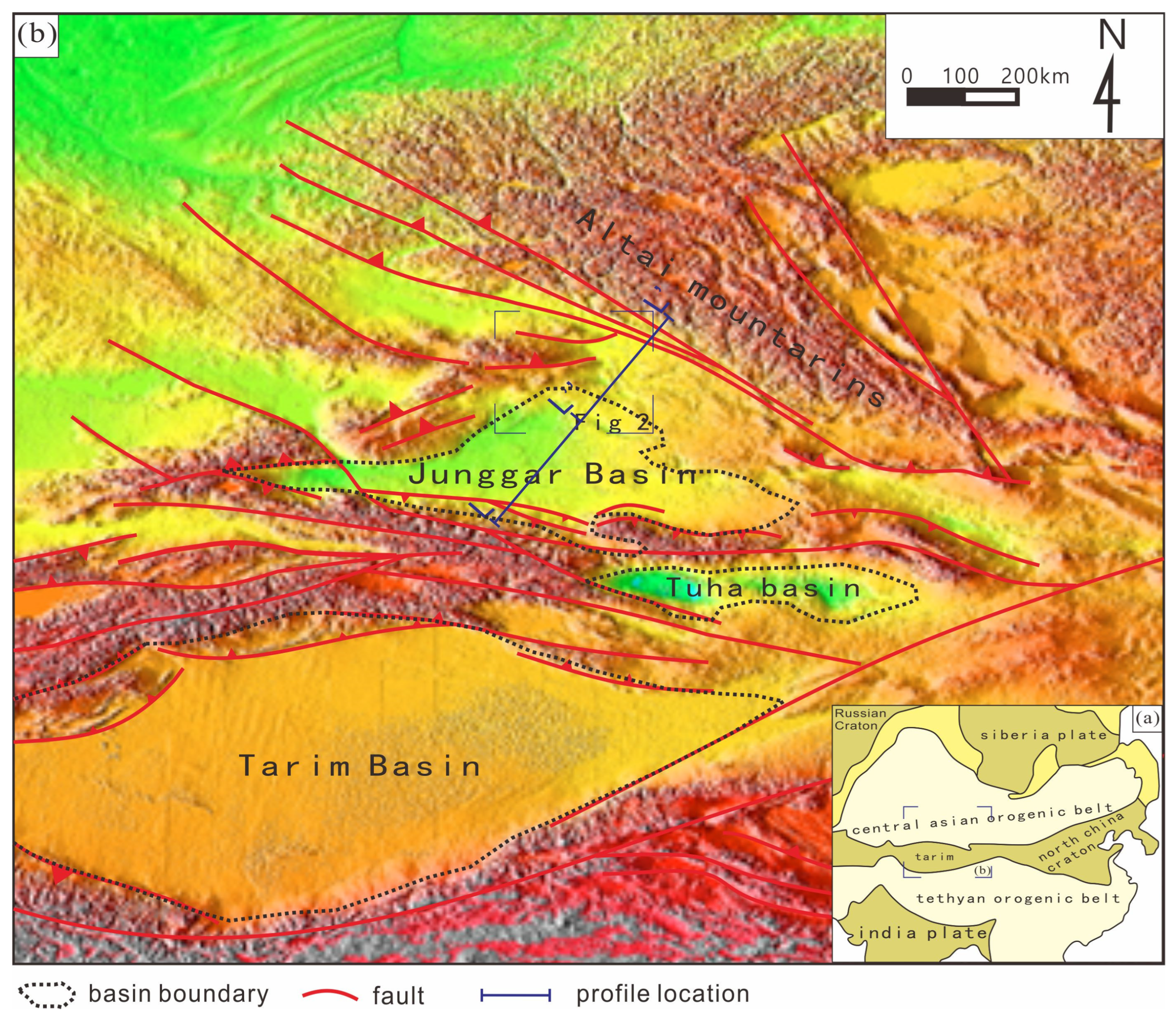
The Central Asian Orogenic Belt (CAOB), situated at the heart of the Asian continent and bounded by the Siberian Plate, Russian Craton, Tarim Block, and North China Craton (
Figure 1a), represents Earth’s most extensive Phanerozoic continental crustal accretion and intracontinental modification system. Over its billion-year tectonic evolution, this belt has undergone three distinct phases: (1) continental marginal accretion, (2) post-collisional adjustment, and (3) intracontinental orogenic reorganization. Its complete evolutionary continuum—spanning from oceanic subduction to terminal intraplate deformation—coupled with exceptional metallogenic and hydrocarbon endowment, establishes the CAOB as a natural laboratory for investigating continental evolution mechanisms and associated mineralizing processes [
1,
2,
3,
4,
5,
6].
The Junggar Basin, located in the southern CAOB, forms a triangular structural domain bounded by the Tianshan Orogenic Belt to the south, Altai Orogenic Belt to the northeast, and the discontinuous Zaire and Hara-Airat Mountain Ranges to the northwest (
Figure 1b). This Meso-Cenozoic sedimentary basin developed atop a Paleozoic basement, with its evolution fundamentally controlled by syn-tectonic activities of surrounding orogenic belts.
The Tianshan Orogenic Belt, situated along the southern basin margin (
Figure 1b), originated as a Late Paleozoic–Mesozoic collisional system. Reactivated during the Cenozoic as an intracontinental orogen due to far-field stresses from the India-Eurasia collision, it generated a coupled intracontinental orogenic belt and foreland basin system. Notably, Cenozoic intracontinental deformation in the North Tianshan induced intense fold-thrust systems along the southern Junggar Basin margin, profoundly influencing the basin’s Cenozoic structural architecture, strain partitioning, and sedimentological regimes [
11].
To the northeastern basin margin, the Altai Orogenic Belt extends into Mongolia, Russia, and Kazakhstan (
Figure 1b). This belt records Late Paleozoic collisional tectonics between the Siberian Plate and Kazakhstan Block, transitioning to an intracontinental orogenic regime since the Mesozoic [
12,
13]. Meso-Cenozoic reactivation generated pronounced compressional structures along the northeastern Junggar Basin, characterized by thrust belt propagation and basement-involved shortening.
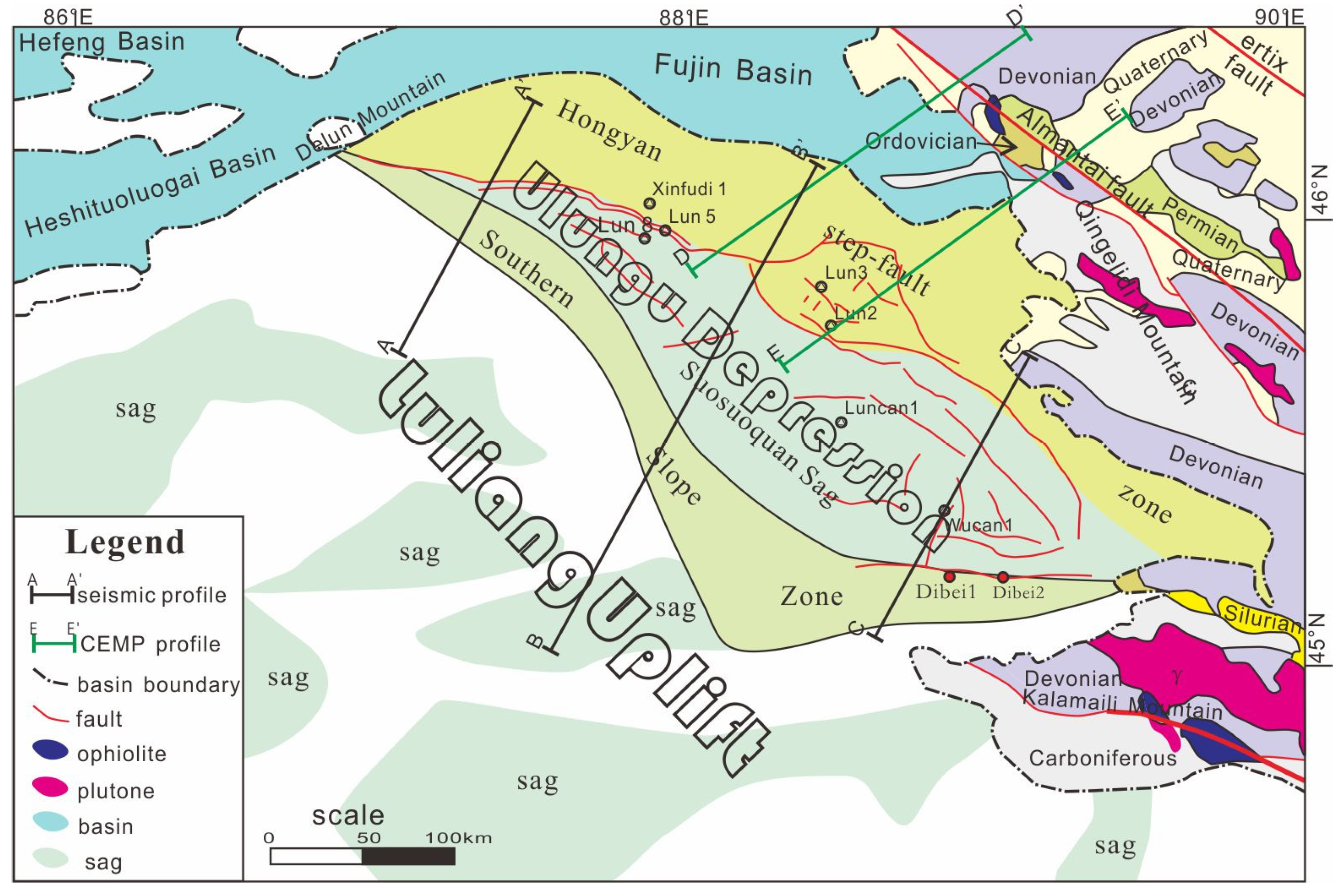
The Ulungu Depression, a first-order tectonic unit in the northeastern Junggar Basin, displays a NW-trending rhombic geometry bounded by the Qinggelidishan–Fujin Basin to the northeast, the Luliang Uplift to the southwest, the Delun Mountains to the northwest, and the Kalamaili Piedmont to the southeast (
Figure 2). Underlain by Carboniferous basement, its stratigraphic succession comprises Upper Triassic, Jurassic, Cretaceous, and Cenozoic strata. Structurally, the depression is subdivided into three second-order units: (1) the Hongyan Thrust Terrace Belt, (2) the Suosuoquan Sag, and (3) the Southern Slope Zone [
9,
14].
The Hongyan Thrust Terrace Belt, located along the northeastern margin, constitutes a thrust-nappe system with large-scale reverse faults. Mesozoic strata in this belt have been largely uplifted and eroded, resulting in Cenozoic deposits unconformably overlying the Carboniferous basement. Major fault systems include the Tusituoyila, South Well Lun-2, Ulungu East, Hongpen, and Kalasayi faults (
Figure 2). The Suosuoquan Sag, a NW-SE elongated depocenter, features thick Jurassic-Cretaceous sedimentary sequences, representing the depression’s main subsidence domain. The Southern Slope Zone exhibits gradual basement uplift toward the Luliang Uplift, accompanied by Jurassic thinning and subtle Upper Triassic attenuation in the same direction.
Mesozoic intracontinental orogeny in the Altai Orogenic Belt induced intense compressional deformation within the Ulungu Depression, accompanied by deposition of thick medium-to-coarse clastic successions [
16]. Late Cretaceous to Paleogene peneplanation events [
17,
18,
19,
20] are recorded by a regional Paleogene basal unconformity, overlain by undeformed Cenozoic strata.
While Meso-Cenozoic tectonic evolution of the depression has been extensively studied, critical knowledge gaps persist regarding: Paleozoic structural architecture and its inheritance effects; precise tectonic coupling mechanisms between the Ulungu Depression and Altai Orogenic Belt; and strain-partitioning patterns during Late Paleozoic accretionary phases. Resolving these issues is essential for deciphering the CAOB’s post-Paleozoic continental dynamics and metallogenic processes.
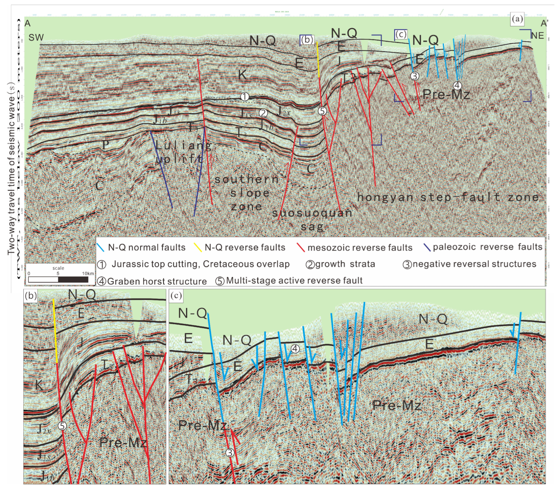
Figure 3.
Seismic profile A-A’ across the Ulungu Depression. (a) A-A’ profile; (b,c) Interpretation map of local seismic sections.
Figure 3.
Seismic profile A-A’ across the Ulungu Depression. (a) A-A’ profile; (b,c) Interpretation map of local seismic sections.
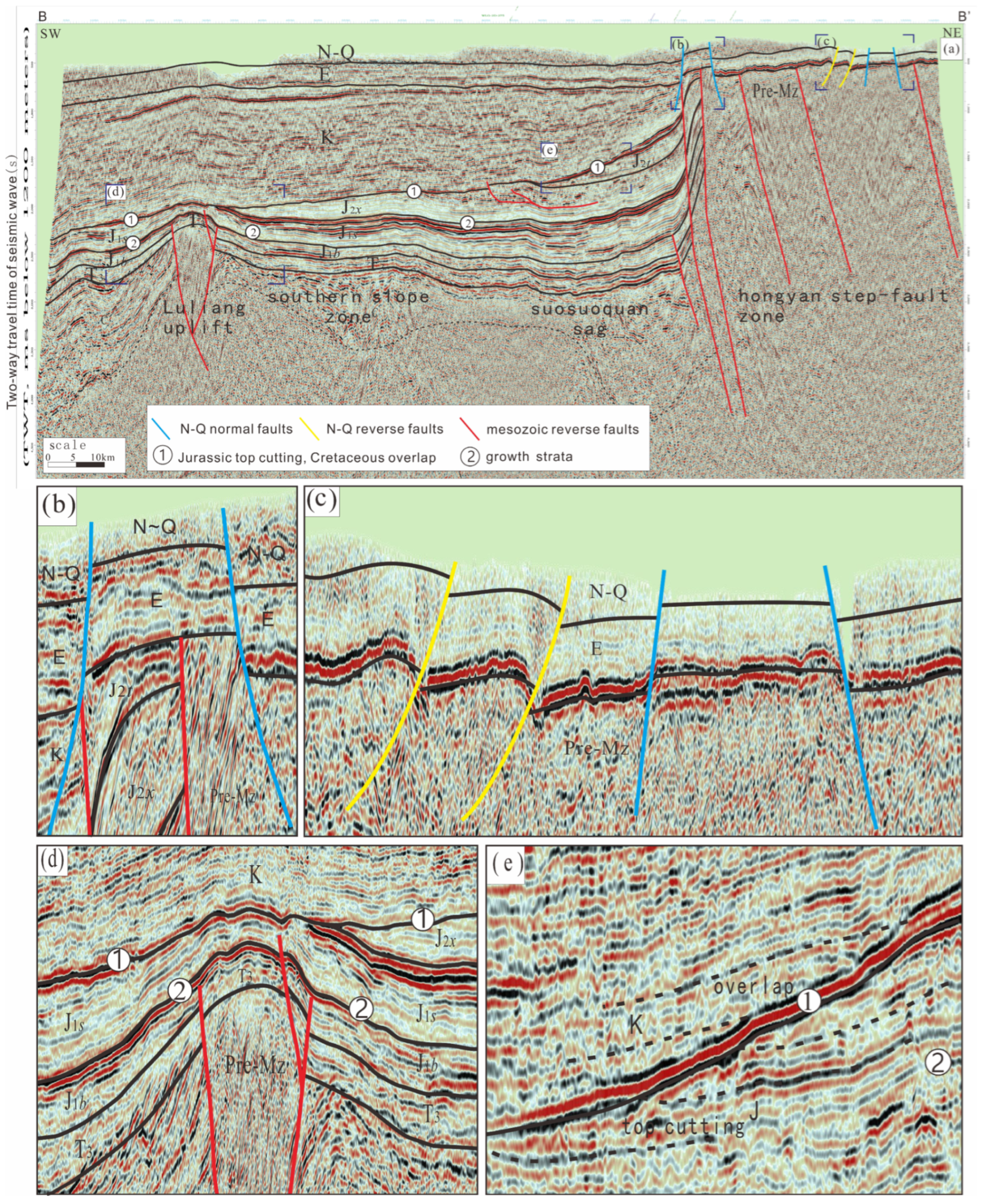
Figure 4.
Seismic profile B-B’ across the Ulungu Depression. (a) B-B’ profile; (b–e) Interpretation map of local seismic sections.
Figure 4.
Seismic profile B-B’ across the Ulungu Depression. (a) B-B’ profile; (b–e) Interpretation map of local seismic sections.
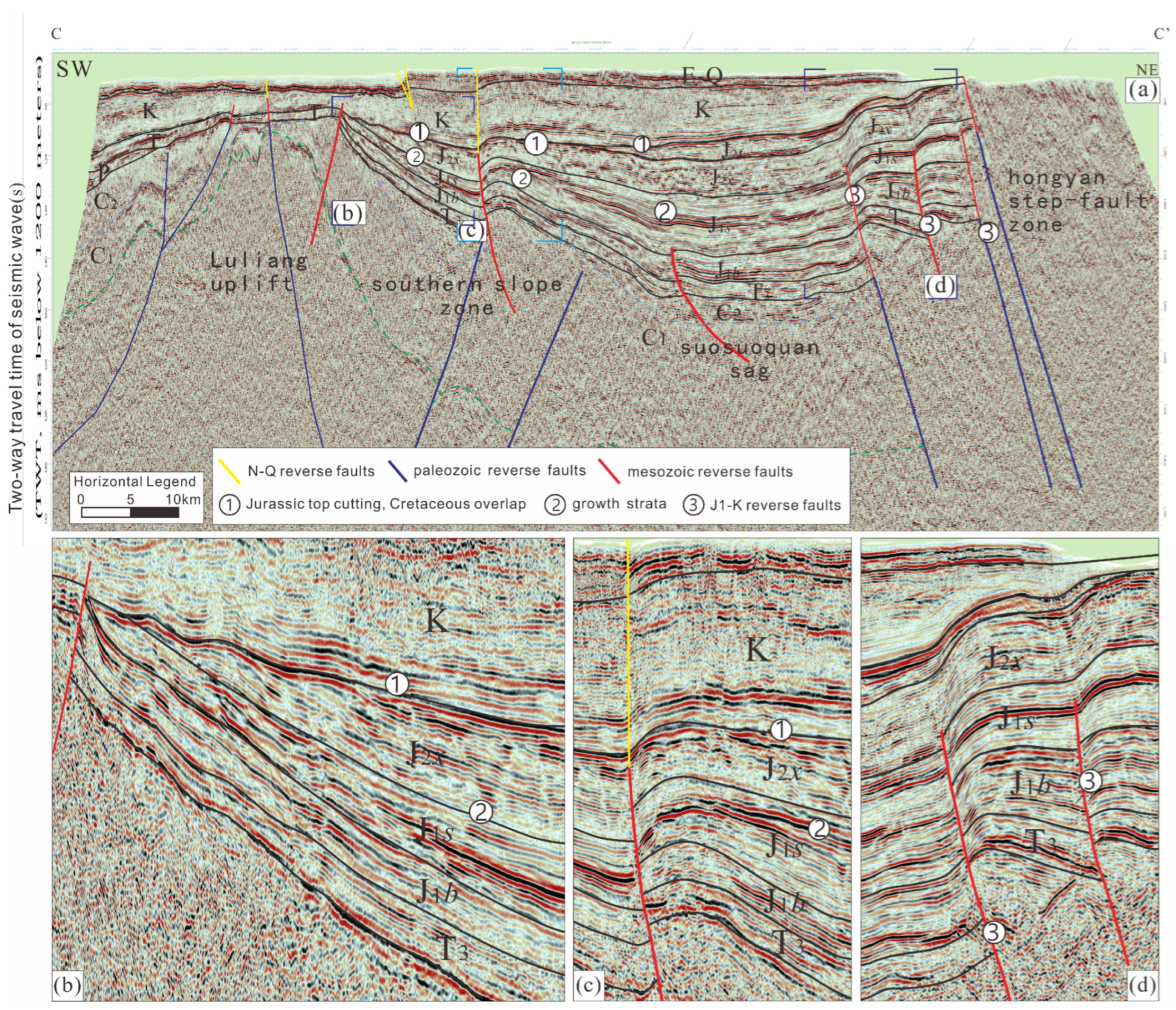
Figure 5.
Seismic profile C-C’ across the Ulungu Depression. (a) C-C’ profile; (b–d) Interpretation map of local seismic sections.
Figure 5.
Seismic profile C-C’ across the Ulungu Depression. (a) C-C’ profile; (b–d) Interpretation map of local seismic sections.
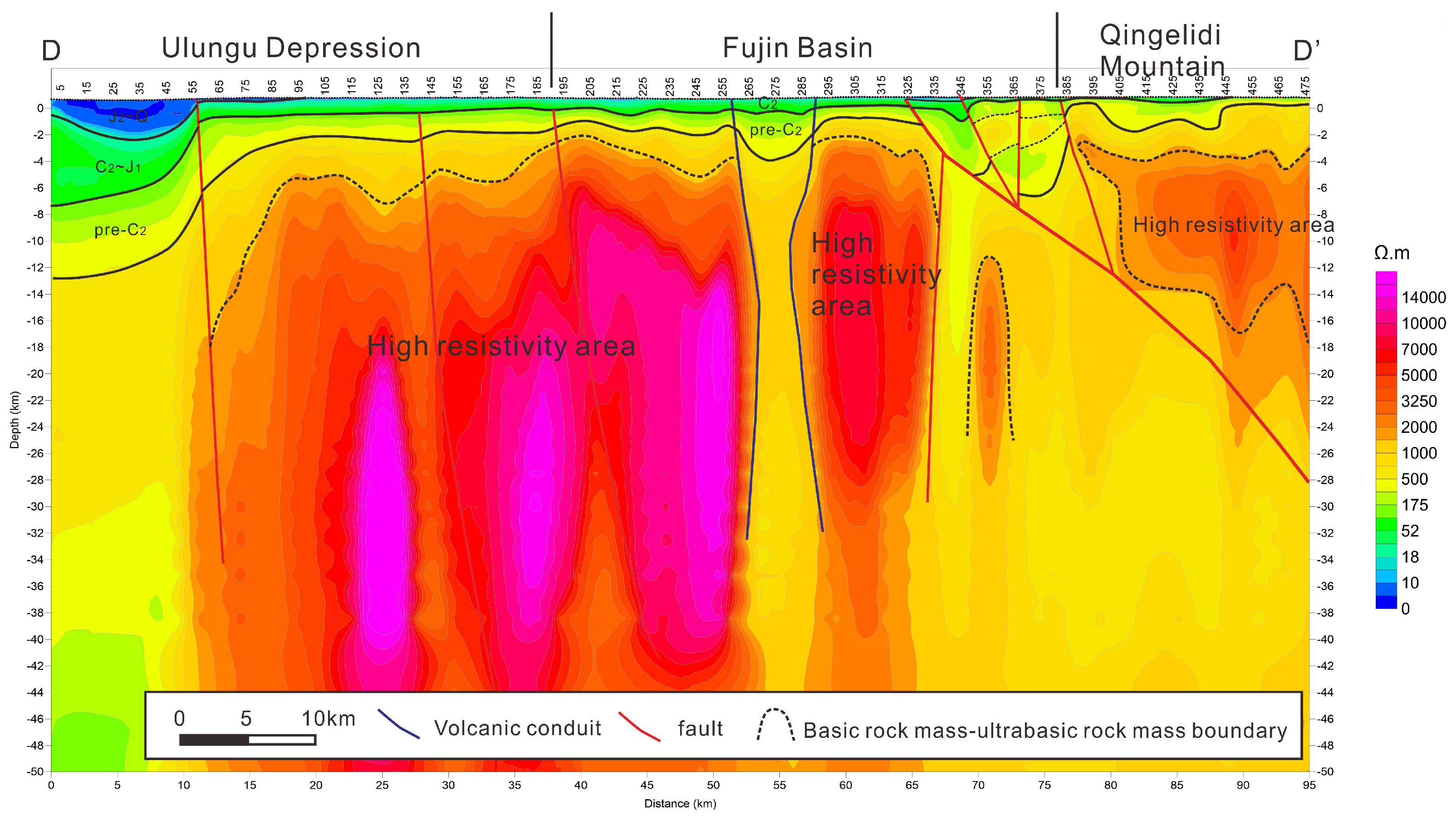
Figure 6.
Interpretation of geological structure of D-D’ electrical section in northeastern Junggar Basin.
Figure 6.
Interpretation of geological structure of D-D’ electrical section in northeastern Junggar Basin.
The deep seismic data in the study area are of poor quality, making it difficult to extract useful information. In this paper, we reinterpret the deep geological structure using newly acquired Continuous Electromagnetic Profiling (CEMP) data, combined with seismic data interpretation, which provides a basis for investigating the Paleozoic tectonic framework and the basin–mountain coupling mechanism in the study area.
2. Methods
Continuous Electromagnetic Profiling (CEMP) is a magnetotelluric (MT) sounding technique developed from Electromagnetic Array Profiling (EMAP). Through array-type observations that densely acquire multi-channel electric field signals, combined with low-pass filtering and other processing techniques, this method effectively suppresses static-shift disturbances caused by near-surface inhomogeneities, and is capable of providing electrical structure information from shallow to deep depths. The CEMP method is not shielded by high-resistivity (or high-velocity) formations, and can be deployed in carbonate-rock and igneous-rock covered areas, piedmont zones, and complex topographic regions. It is suitable for studying regional geological structures, basement relief and burial depth, fault distributions, and local structural styles in sedimentary basins.
2.1. Data Acquisition
In this study, two NE–SW trending CEMP survey lines, D-D’ (CEMP02) and E-E’ (CEMP01), were deployed in the Ulungu Depression on the northeastern margin of the Junggar Basin (
Figure 2). Field data acquisition was carried out in the tensor measurement mode, recording the five electromagnetic field components Ex, Ey, Hx, Hy, and Hz. Along the survey lines, electric dipoles were arranged in an end-to-end array configuration to densely sample multi-channel electric signals. Two CEMP lines with a combined length of 200 km were deployed in the Ulungu Depression, with a station spacing of 200 m, yielding 1004 coordinate points and 11 check points. The GPS network consisted of 3 GPS stations, including two national triangulation points and one newly established point. For positioning, 1054 GPS physical points and 50 check points were completed. CEMP acquisition covered 1017 physical points, among which 12 were check points; one well-side sounding point was also occupied. Additionally, 215 physical property specimens were collected.
2.2. Data Processing and Inversion
CEMP data processing is a critical step in converting electrical data into geological information. It includes general processing, qualitative processing, quantitative inversion, and electrical stratification.
General processing involves: applying Fourier transform to the acquired time-series signals to obtain the spectra of the five electromagnetic components Ex, Ey, Hx, Hy, and Hz, and then calculating the impedance tensor Z and tipper Tp parameters; performing impedance tensor decomposition, principal-axis impedance estimation, and TE/TM mode discrimination; applying remote magnetic reference techniques to suppress cultural noise and other interferences; using robust estimation methods to improve the reliability of impedance estimates; applying wavenumber-domain low-pass filtering to suppress static effects; and carrying out static correction.
Qualitative processing employs the Bostick inversion method. The Bostick method is an approximate 1D inversion scheme for magnetotelluric sounding curves; it is computationally fast and simple, and can adequately reflect the basic characteristics of the geoelectric section. It is a necessary step in the CEMP data inversion workflow.
Quantitative inversion comprises 1D continuous-medium inversion and 2D inversion. The 1D continuous-medium inversion assumes that the subsurface resistivity varies continuously with depth, and performs curve-fitting inversion for each individual station. The 2D inversion takes into account lateral variations along the profile: first, an initial model is constructed based on the 1D inversion results and existing geological and drilling information; then, through iterative forward modeling, the misfit between the calculated and observed apparent resistivities is minimized to obtain the final inversion result. The inversion incorporates topographic-corrected 2D continuous-medium imaging and uses rock physical property data from surface and borehole measurements to build relevant geological models, thus constraining the CEMP inversion to yield the subsurface electrical structure.
2.3. Integrated Interpretation of Seismic and CEMP Data
In this study, the electrical structure sections obtained from CEMP inversion were interpreted together with 2D reflection seismic profiles. The seismic data provide information on shallow-to-medium structural geometry and stratigraphic contacts, while the CEMP data compensate for the poor quality of deep seismic reflections; the two datasets mutually constrain and validate each other. For electrical layer calibration, we referred to resistivity logs and lithological records from boreholes in the study area (e.g., wells Lun 5, and Lun 2) to establish the relationship between lithology and resistivity, and to unify the electrical interfaces in the CEMP sections with the seismic reflection horizons. Through this integrated interpretation approach, a continuous geological structure section from shallow to deep was constructed, providing a reliable geophysical basis for investigating the basin–mountain coupling mechanism between the Ulungu Depression and the Altai Orogenic Belt.
3. Stratigraphic Overview
The Ulungu Depression is a Mesozoic–Cenozoic depression developed on the Carboniferous basement, and the tectonic evolution controls the sedimentary characteristics of the strata. The main sedimentary strata above the Carboniferous basement are Upper Triassic, Jurassic, Cretaceous, Paleogene, Neogene and Quaternary, and the Permian and Lower and Middle Triassic are missing (
Table 1).
The Carboniferous (C) is the basement structural layer of the Ulungu Depression [
8], which is dominated by volcanic rocks with sedimentary rocks. The Carboniferous strata drilled in wells Xinfudi 1, Lun 5 and Lun 8 are mainly a set of tuff and tuffaceous sandstone with tuffaceous mudstone.
The Upper Triassic Baijiantan Formation (T3b) is stably distributed in the whole area, mainly composed of lacustrine delta sandstone and mudstone, and locally contains carbonaceous mudstone.
The sedimentary thickness of Jurassic (J) is large, mainly composed of braided river, delta and shore-shallow lake facies sand mudstone. The Lower Jurassic Badaowan Formation (J1b) is a set of coal-bearing rock series, mainly composed of coarse clastic rocks, and a set of bottom conglomerate is often deposited at the bottom. The Lower Jurassic Sangonghe Formation (J1s) is dominated by pebbly sandstone, fine sandstone, siltstone and mudstone. The Xishanyao Formation (J2x) of the Middle Jurassic is composed of gray glutenite, sandstone, mudstone, coal seam or carbonaceous mudstone. There are 2~3 positive sequence sedimentary cycles, and the coal seams are stably distributed in the whole area. The Middle Jurassic Toutunhe Formation (J2t) is composed of gray mudstone, silty mudstone, argillaceous siltstone and brown-gray sandstone, which are interbedded with different thickness and form multiple normal sequence cycles.
The Lower Tugulu Group (K1tg) and the Upper Donggou Formation (K2d) are developed in the Cretaceous (K). The Tugulu Group (K1tg) is mainly composed of gray-green fine sandstone and brown, brownish red, gray-green mudstone with siltstone, and a set of gray-green breccia is occur at the bottom. The upper part of the Luodonggou Formation (K2d) is interbedded with purplish red mudstone and argillaceous siltstone. The lower part is composed of purplish red siltstone with red mudstone and silty mudstone, and the bottom is composed of variegated and gray-black glutenite with purplish red mudstone.
The Paleogene (E) deposits are relatively stable, with a thickness of 50~150 m. The lithology is mainly mudstone and siltstone, and pebbly sandstone is developed at the top and bottom.
The sedimentary thickness of the Neogene (N) varies greatly, and the thickness of the stratum is 0~500 m. The lithology is mainly mudstone and silty mudstone, and locally sandwiched with lenticular sandy conglomerate.
The thickness of Quaternary (Q) is 100~500 m, which is semi-consolidated-consolidated. The lithology is mainly sandstone, mudstone and glutenite.
4. Tectonic Deformation Styles
4.1. Late Cenozoic Extensional Structures: Neogene–Quaternary Normal Faults
On the basis of fine seismic profile interpretation, we found for the first time that the Neogene–Quaternary normal faults were developed in the Ulungu Depression (
Figure 3c and
Figure 4b,c). Some of these normal faults are developed in pairs to form graben-horst structures (
Figure 3 ④), and some are developed on the early reverse faults to form negative inversion structures (
Figure 3 ③). The latest strata of normal fault show that the activity time of these normal faults is mainly Neogene–Quaternary (
Figure 4b,c). Because the main body of the Mesozoic and Cenozoic in the Ulungu Depression is dominated by compressional structural deformation, and the development scale of normal faults is small, these normal faults are easily ignored by researchers. In the context of regional compressional tectonics, the discovery of these normal faults is of great significance for studying the Mesozoic–Cenozoic tectonic evolution process in the region.
4.2. Syn-Sedimentary Strata During the Uplifting Process of Luliang Uplift: Upper Triassic and Jurassic Growth Strata in the Southern Slope Zone
Based on the internal unconformity surface, growth anticline and thrust fault of Jurassic in Ulungu Depression, the predecessors believed that the main tectonic deformation of Jurassic in Ulungu Depression was strong extrusion thrust structure, and carried out a lot of research on the deformation characteristics and formation time of extrusion structure, and obtained good research results [
9,
15]. The Jurassic compressive tectonic deformation does exist, but the growth strata developed along the northern slope of the Luliang uplift, that is, the southern slope of the Ulungu Depression (
Figure 3 ②,
Figure 4 ② and
Figure 5 ②) indicate clearer geological information. These geological information clearly record the activity process of Luliang uplift in Mesozoic, and provide a reliable geological basis for the reconstruction of Mesozoic tectonic framework and tectonic evolution process in Ulungu Depression.
The overall sedimentary thickness of the Upper Triassic is relatively stable, and there is a slight thinning in the direction of the Luliang uplift. The characteristics of the growth strata are the weakest, and the Triassic in some areas is cut off by the boundary fault of the land beam uplift. The thinning trend of the Jurassic to the Luliang uplift is more obvious, and the growth strata are very developed. Relatively speaking, the Jurassic compressive tectonic deformation is only manifested as broad folds and local thrust structures, while the growth strata indicate the Luliang uplift from the Late Triassic. The long-term uplift process continued to the Late Jurassic and controlled the structural pattern and stratigraphic sedimentary characteristics of the Ulungu Depression.
4.3. Three Regional Unconformity Surfaces: Upper Triassic Bottom Unconformity Surface, Jurassic Top Unconformity Surface and Paleogene Bottom Unconformity Surface
In addition to the secondary unconformities developed in the Jurassic, Cretaceous or Cenozoic (the bottom conglomerate is generally developed on the unconformities, mainly parallel unconformities or small-angle unconformities), three major regional unconformities are mainly developed in the Mesozoic and Cenozoic in the Ulungu Depression, which are the bottom unconformities of the Upper Triassic, the cutting unconformities of the Jurassic top and the cutting unconformities of the Paleogene bottom.
The Ulungu Depression lacks the Permian and the Lower and Middle Triassic, and the Upper Triassic directly covers the Carboniferous, forming a regional unconformity between the Upper Triassic and the Carboniferous basement (
Figure 3a,
Figure 4a and
Figure 5a). The unconformity surface was formed from the Permian to the Middle Triassic regional uplift and denudation. The top of the Carboniferous suffered a certain degree of denudation until the Late Triassic Ulungu Depression began to settle and re-accept the deposition. On the seismic section, the unconformity surface is very obvious. The Carboniferous reflection under the unconformity surface is messy, and there are local stratigraphic reflection axes but not continuous. The Carboniferous surface in this area is less exposed, and the drilling part reveals the main source of understanding the Carboniferous. The Mesozoic–Cenozoic reflection axis above the unconformity is clear and continuous. The unconformity surface is an important tectonic event from the Permian to the early Mesozoic in this area. It is speculated that it is the product of collisional orogenic uplift and denudation in the Late Paleozoic of Ulungur. Due to the limitation of space, this paper will not discuss it in detail.
The Jurassic residual strata as a whole is a wedge-shaped body thinning towards the Luliang uplift. On the one hand, the original deposition is thinning towards the Luliang uplift; on the other hand, the continuous uplift of the Luliang uplift in the Late Jurassic–Early Cretaceous led to the erosion of the top of the Jurassic, and the closer to the Luliang uplift, the greater the amount of erosion. On the top surface of the residual Jurassic, it can be clearly seen that the Jurassic layer is cut by the top surface (
Figure 3 ①,
Figure 4 ① and
Figure 5 ①), indicating that the Jurassic top is cut and eroded, forming the Jurassic top cut unconformity. The closer to the Luliang uplift, the greater the angle of the unconformity surface cutting the Jurassic layer, the smaller the residual thickness of the Jurassic, indicating that the denudation center is in the Luliang uplift, which is caused by the continuous uplift of the Luliang uplift.
From the end of the Cretaceous to the beginning of the Paleogene, the Ulungu Depression was almost uplifted and denuded, and the unconformity surface of the Paleogene bottom was formed. In the Hongyan fault terrace zone, the unconformity between the Paleogene and the pre-Mesozoic strata (Carboniferous) is shown, and in the Suosuoquan sag and the Southern Slope Zone, a small-angle unconformity between the Paleogene and the Cretaceous was shown. All Mesozoic strata in Hongyan fault terrace zone have been uplifted and denuded, indicating that the uplift range of Hongyan fault terrace zone is very large. The closer to the Hongyan fault terrace, the more obvious the Cretaceous top unconformity, the greater the amount of erosion of the Cretaceous top. On the contrary, the erosion amount of Cretaceous in the direction of Luliang uplift decreases, and gradually transits from angular unconformity to parallel unconformity. It shows that the driving force of the formation of this unconformity comes from the direction of the Hongyan step-fault zone. The uplift amplitude increases in the direction of the Hongyan step-fault zone and decreases in the direction of the Luliang uplift.
4.4. Overlapping Deposition: The Cretaceous Overlaps on the Top of the Jurassic Unconformity
Through fine seismic profile interpretation, it is found that the Cretaceous has the characteristics of overlap deposition towards the Hongyan step-fault zone (
Figure 3 ①,
Figure 4 ① and
Figure 5 ①). It shows that during the formation of the Hongyan fault terrace, the Jurassic in the footwall of the Hongyan fault terrace was dragged and uplifted to form a slope inclined towards the Luliang uplift, and the Cretaceous was overlain on the slope from southwest to northeast. The whole process has experienced the process of Jurassic being dragged and uplifted by Hongyan fault terrace and Cretaceous overlapping deposition. The time of these two events is closely linked or almost simultaneous.
4.5. Deep Structure: Magmatic Intrusion, Volcanic Channel and Plate Collision
To the north of the Ulungu Depression, there are two NE-SW electrical profiles (
Figure 2), which are D-D’ (CEMP02) profile and E-E’ (CEMP01) profile, which can roughly reveal the deep geological structure characteristics.
The two electrical profiles reveal that there is a high-resistivity body with a lateral amplitude of 50~60 km in the depth of 6 km. By comparing with the resistivity of the surrounding strata, it is considered that this set of strata is likely to be ultrabasic–basic rock mass, representing the deep basement structure. The rock mass of the two profiles can basically correspond well, and the lateral distance of the profile reaches 36 km, indicating that it has a certain scale.
In the D-D’ electrical section, there is a low-resistance body running through the deep part between the high-resistance bodies on both sides at a distance of 50–60 km from southwest to northeast (
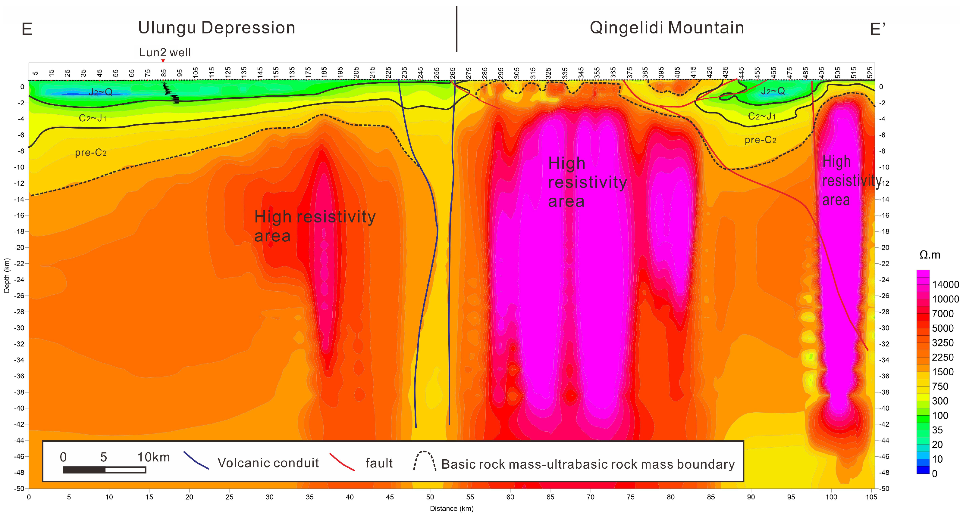
Figure 6). This low-resistivity body also exists in the E-E’ profile (
Figure 7). Through the analysis of surface conditions, the location of the low-resistance body is the Ulungur River (
Figure 8), and the formation of the low-resistance body should be affected by groundwater. The low-resistance body shows vertical penetration on the electrical profile, which proves that the depth of water infiltration is very deep, at least through the deep ultrabasic–basic rock mass, indicating the existence of deep fault communication. The Carboniferous volcanic rocks are widely developed, and this deep fault zone is likely to be a volcanic eruption channel.
The northern part of the D-D’ and E-E’ sections both reveal obvious northward subduction characteristics of the plate. The D-D’ section has an obvious oblique inverted triangular low-resistance body at a depth of 65–80 km and a depth of 0–8 km, which corresponds to the northern triangular high-resistance body (
Figure 6), which is an obvious plate subduction collision structure. In the E-E’ section, this structure forms a recoil fault in the shallow layer (
Figure 7).
4.6. Basin-Mountain Contact Relationship: Joint Control of Forward Thrust and Rigid Rock Mass
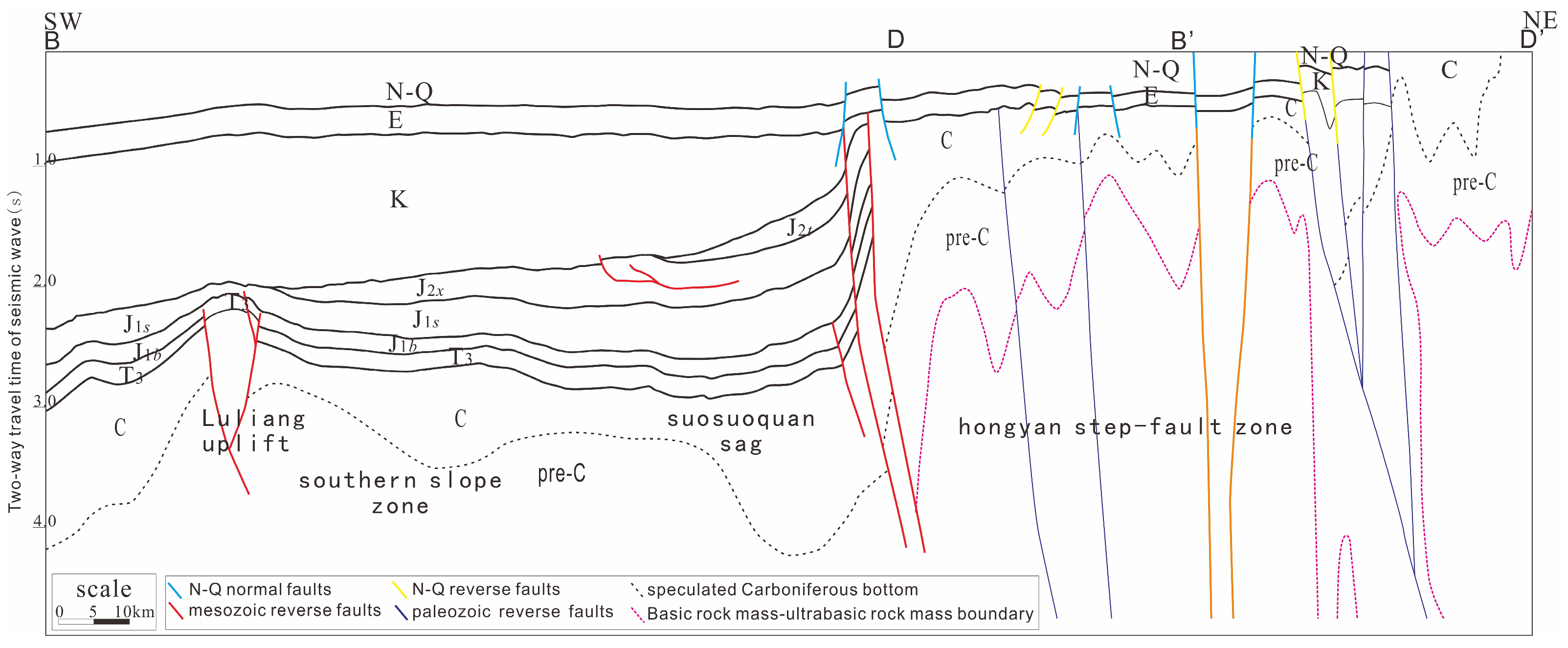
Through the comprehensive interpretation of seismic data and electrical data, the geological structure profile of the northeastern Junggar–Altay Mountains was established (
Figure 8). It can be seen from the section that the basin–mountain contact relationship is not completely distinguished, but after the transition of the subduction zone and the Hongyan fault terrace zone, it transitions from the Altay orogenic belt to the Ulungur depression. During the Cenozoic period, the subduction zone, the Hongyan fault terrace zone and the Ulungu Depression were subsiding as a whole as the receiving sedimentary area. From the Altay orogenic belt to the Ulungu Depression, the tectonic deformation changed from strong to weak. From Paleozoic to Mesozoic to Cenozoic, the tectonic deformation changes from strong to weak.
6. Discussion on the Formation Mechanism
6.1. Late Paleozoic Tectonic Evolution Is Mainly Controlled by Altay–Junggar Collision Orogenic Belt
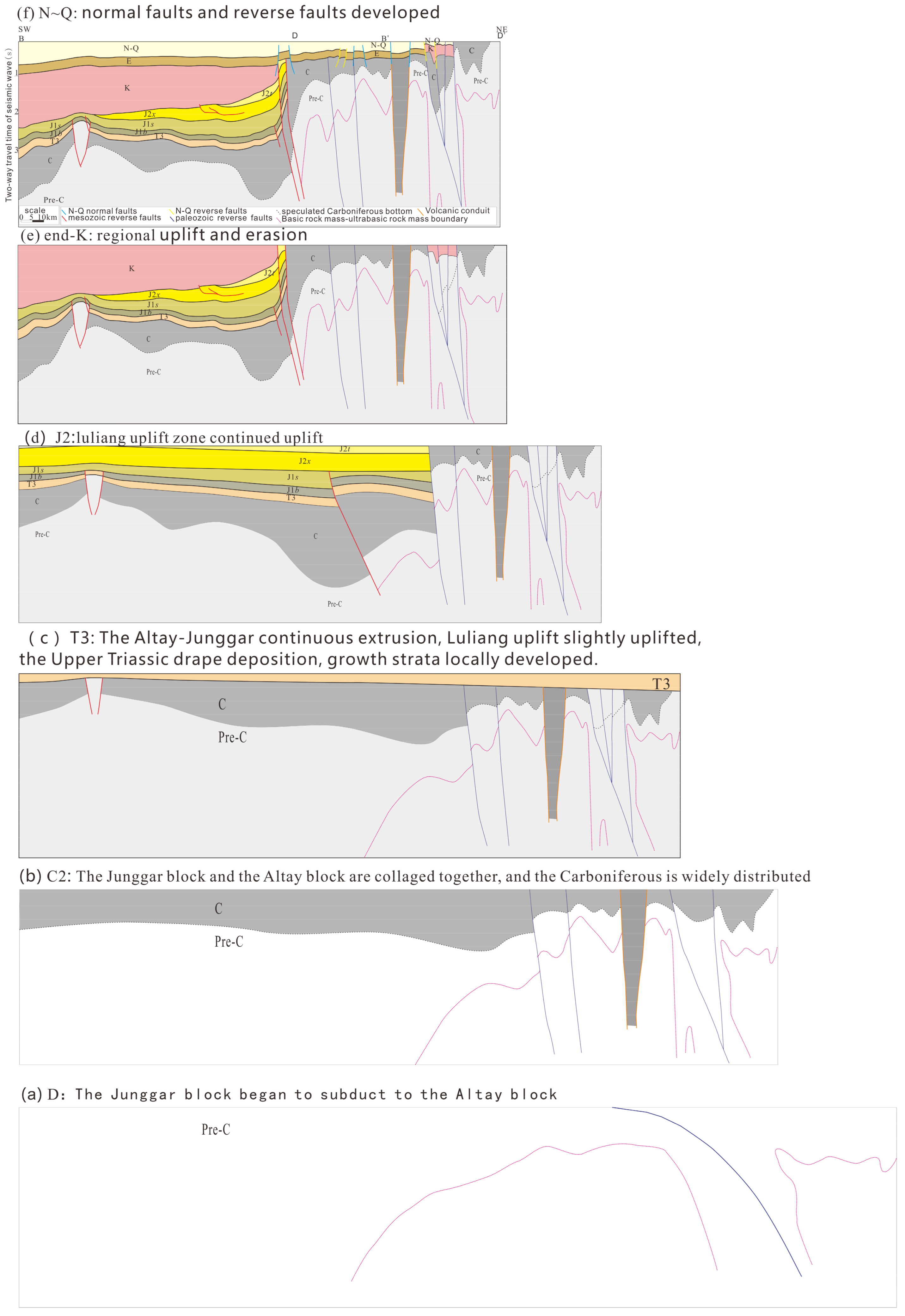
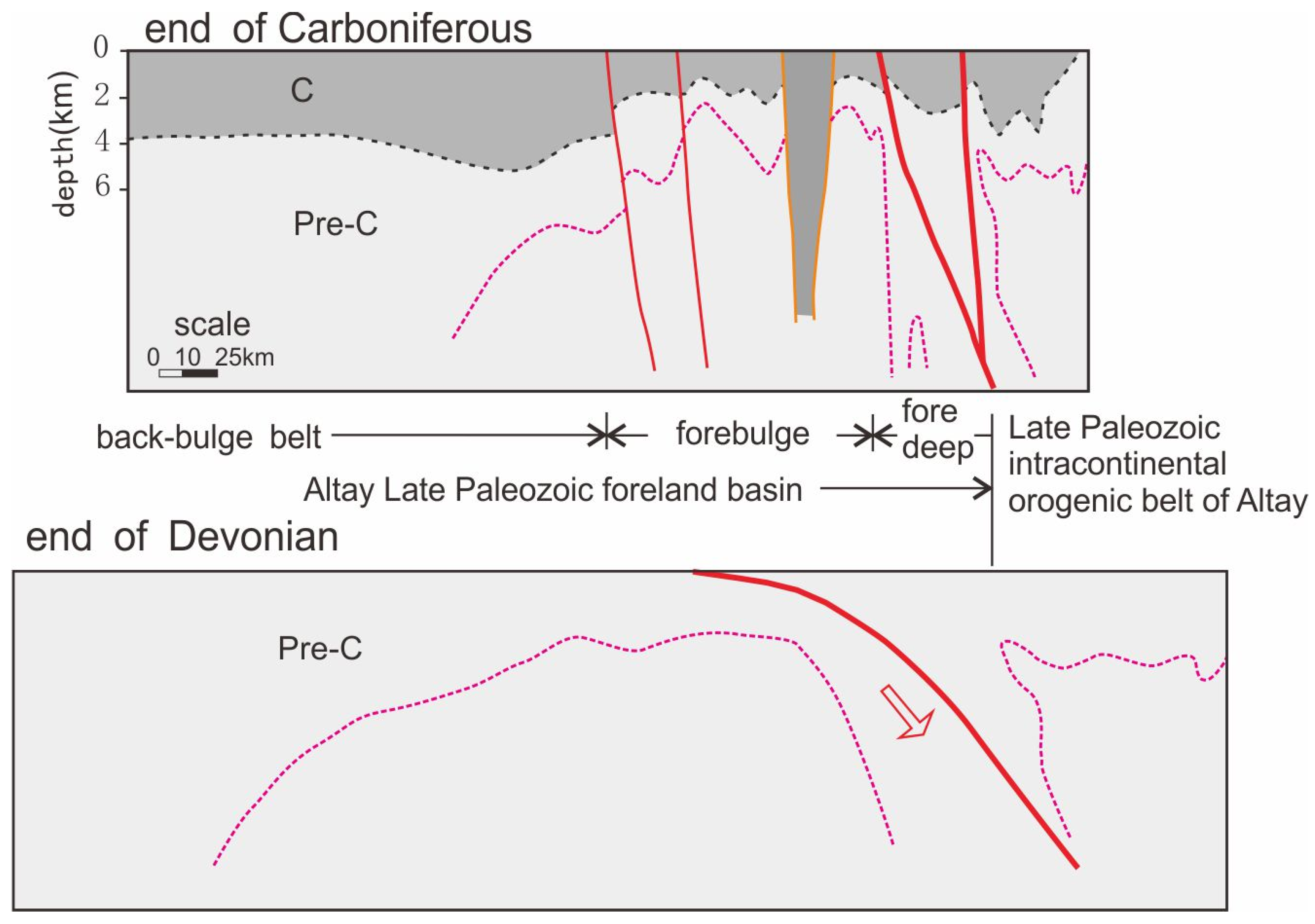
According to the electrical profile interpretation, there is a subduction zone between the Ulungu Depression and the Altay orogenic belt, which is speculated to be the Devonian–Carboniferous subduction collision zone, and a collision foreland basin is formed in the Ulungu area. Extensive volcanic eruptions occurred in the late stage of the subduction collision, forming a wide range of Late Carboniferous volcanic rocks [
21]. During the intermission of volcanic eruptions, extensive sedimentary strata were deposited and thickened in the foredeep zone and back-bulge zone (
Figure 10).
6.2. Mesozoic Tectonic Evolution Is Mainly Controlled by Altay Intracontinental Orogenic Belt
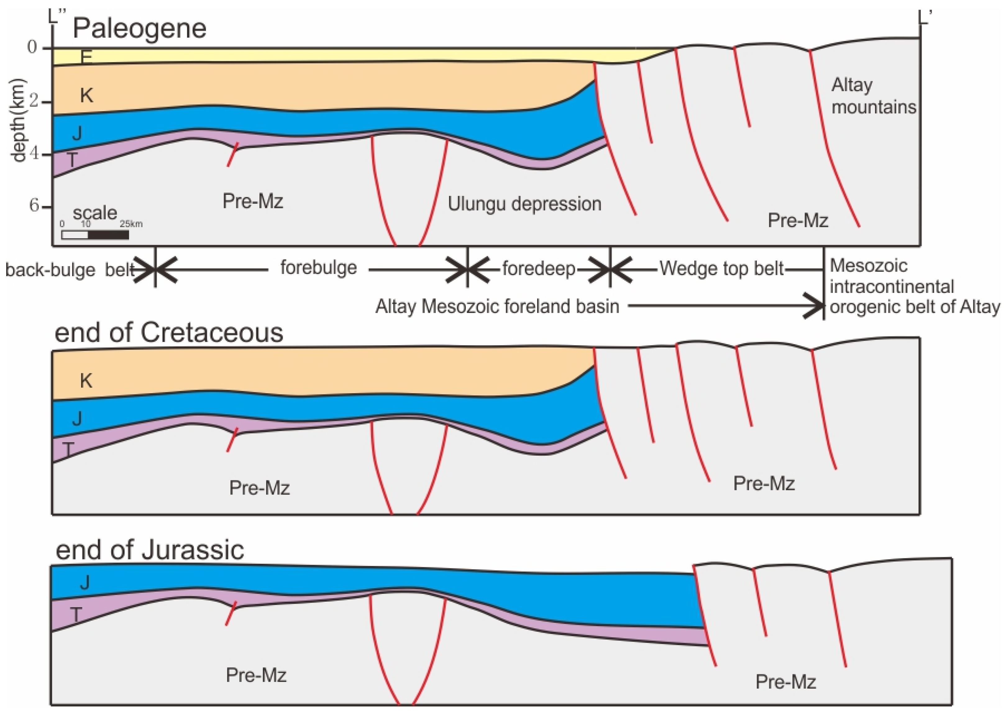
According to the interpretation of seismic profile and the restoration of balanced evolution profile, the stress source of Mesozoic tectonic deformation in Ulungu Depression is the direction of Altay Mountains. In the Mesozoic, the Ulungu Depression is a part of the foreland basin system on the southern margin of the Altay intracontinental orogenic belt, and its tectonic evolution process is mainly controlled by the Mesozoic activities of the Altay orogenic belt (
Figure 11).
In the Early–Middle Triassic, the Ulungu Depression inherited the uplift and denudation environment since the Permian, and lacked the middle and lower Triassic, which should be formed by the Late Paleozoic collision orogenic uplift and denudation in the Ulungu area until the Middle Triassic.
In the Late Triassic, the Ulungu area began to settle and accept deposition, and the Luliang uplift slowly uplifted, indicating that the Altay Mountains had just begun to resurrect, but the intensity was not large, and the thickness of the Upper Triassic did not change much as a whole.
In the Jurassic, the wedge-top zone of the Altai intracontinental orogenic belt spread to the Almantai fault. At this time, the Hongyan step-fault zone had not been formed. The Ulungu Depression was in the foredeep zone of the intracontinental foreland basin, and the Luliang uplift continued to rise as the forebulge zone. The Jurassic system is thinnest in the Luliang uplift zone and thickened in the direction of the Suosuoquan sag. The uplift and denudation of the Altay orogenic belt provides a rich source for the rapid deposition of terrigenous debris. From the Late Jurassic to the Early Cretaceous, with the continuous uplift of the Luliang uplift, the uplift rate was greater than the growth rate of the accommodated sedimentary space, and the top of the Jurassic was denuded.
During the Cretaceous period, the wedge-top zone of the Altay intracontinental foreland basin continued to expand southward to the Hongyan fault terrace zone. The Mesozoic was uplifted and denuded, and the Carboniferous was exposed to the surface (later covered by Cenozoic sediments). The Jurassic in the footwall of the Hongyan fault terrace zone was dragged and uplifted to form a slope inclined to the Luliang uplift. The Cretaceous overlain the slope and formed an unconformity surface with the Jurassic top cutting surface. At the end of the Cretaceous, the intracontinental orogeny continued to advance, and the Ulungu Depression was uplifted and denuded from northeast to southwest, forming an unconformity surface at the bottom of the Paleogene. The unconformity surface gradually transited from the angular unconformity of the Hongyan step-fault zone to the small-angle unconformity or near-parallel unconformity of the Southern Slope Zone.
During the Paleogene, the intracontinental orogeny of Altay gradually weakened and the strata were deposited stably.
6.3. Cenozoic Tectonic Evolution Is Mainly Cosntrolled by the North Tianshan Intracontinental Orogenic Belt
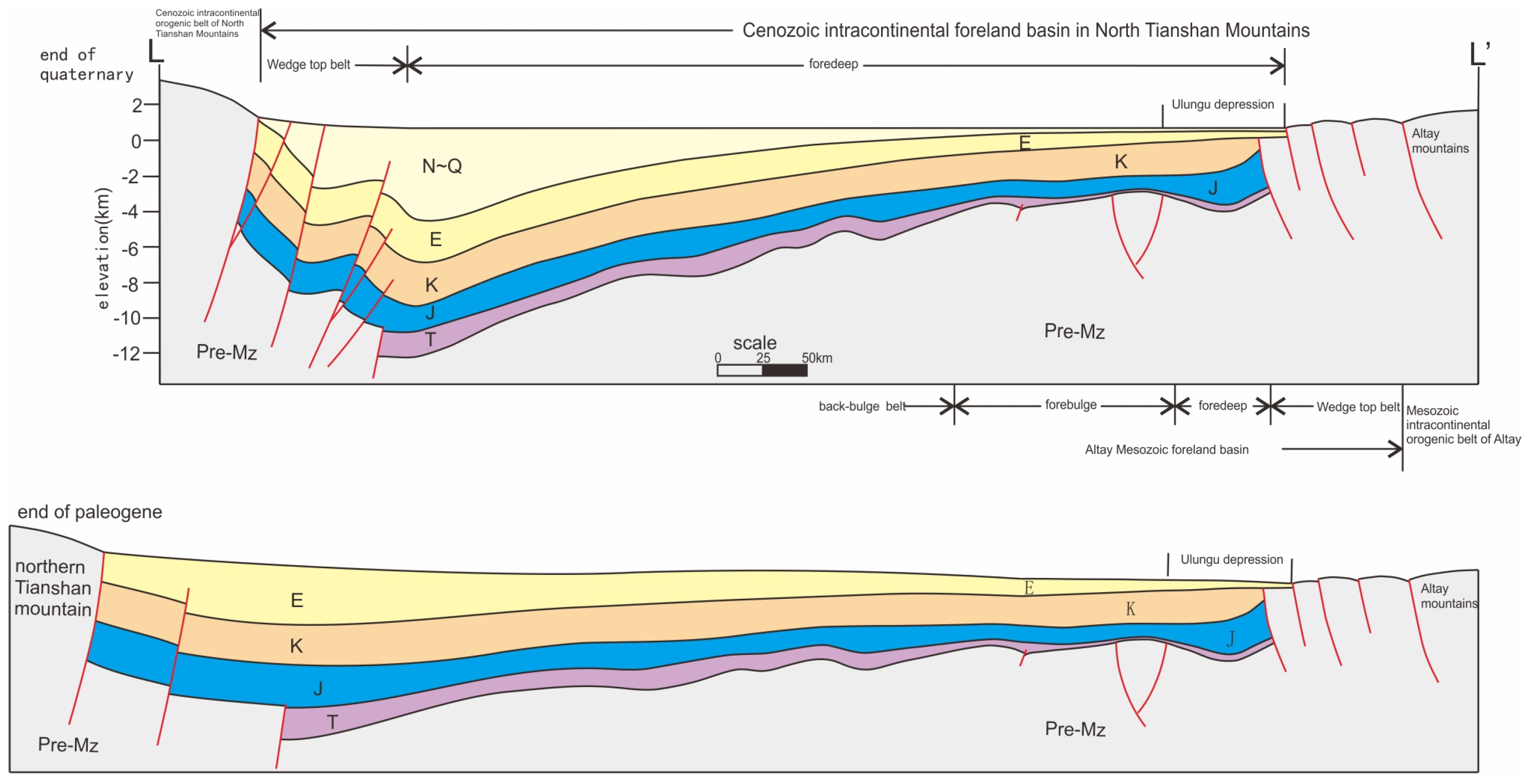
The most important tectonic event in the Cenozoic Eurasian continent is the India-Eurasia plate collision, which directly caused the strong uplift of the Himalayas and the Qinghai–Tibet Plateau, and led to the resurrection of the Tianshan Orogenic Belt across the Tarim Basin. The Ulungu Depression is far away from the Tianshan Mountains, but it is still controlled by the Cenozoic intracontinental orogenic belt of the North Tianshan Mountains. It is a cross superposition area of the Altay Mesozoic foreland basin system and the Cenozoic foreland basin system of the North Tianshan Mountains (
Figure 12).
In the Paleogene, the intracontinental orogeny of the northern Tianshan Mountains was still weak, and the Ulungu Depression stabilized the Paleogene.
In the Neogene–Quaternary, the North Tianshan Mountains experienced a strong intracontinental orogeny, forming a Cenozoic intracontinental foreland basin in the North Tianshan Mountains. In the southern margin of the Junggar Basin, a strong fold-thrust structure was formed, and a thick layer of Neogene–Quaternary was deposited. The Ulungu Depression is far away from the northern Tianshan Mountains, and the compressional structure deformation is weak and the formation thickness is small.
In addition, the Neogene–Quaternary normal faults newly discovered in this paper should be the product of stress relaxation during the inter-orogenic period of the North Tianshan intracontinental orogenic belt. During the inter-orogenic period, the compressive stress was relaxed and the extensional structure was developed, and a series of small normal faults were formed in the original compressive deformation zone. In fact, the late Cenozoic normal faults formed by the widely distributed orogenic intervals have been found in the Tarim Basin.
The Neogene–Quaternary normal faults documented in this study are not an isolated phenomenon within the broader India-Eurasia collision system. Similar extensional structures developed under regional compressional regimes have been widely recognized in the Tianshan orogenic belt and the Tarim Basin, providing important regional analogs that support our interpretation of these normal faults as products of episodic stress relaxation during inter-orogenic intervals [
22,
23,
24,
25].
6.4. Global Comparison: The Apennines Foreland Basin System
The polyphase tectonic evolution documented in the Ulungu Depression shares remarkable similarities with the foreland basin systems of the Apennines belt in Italy, where analogous transitions from collisional to intracontinental foreland basin settings have been described.
The Northern Apennines foredeep basin system, as documented by recent studies, exhibits a migrating foredeep-thrust belt complex characterized by the progressive eastward migration of deformation and sedimentation. Marroni et al. (2025) proposed a detailed tectonic evolution of the Macigno-Falterona foredeep basin at the Oligo-Miocene boundary, based on new biostratigraphic and structural data from the Falterona Unit in the Arezzo area [
26]. Their study reveals that this foredeep basin was deactivated not by the frontal thrust migrating at the basin boundary, but by the thrust cutting into the interior of the foredeep basin itself, dividing it into two sectors with contrasting evolutions: the western sector (Macigno Formation) was underthrust to depth (~7 km) beneath the orogenic wedge and experienced anchizone metamorphism, while the eastern sector (Monte Falterona Formation) remained at shallow structural levels and underwent frontal accretion with only diagenetic-grade deformation. This “intra-basinal” thrust migration mechanism provides a critical analog for understanding how foredeep basins can be segmented and deactivated.
Pasqualone et al. (2026) further documented the stages of development of the Northern Apennines Miocene foredeep basin through integrated facies analysis and structural setting of the Marnoso-Arenacea Formation in the Umbrian sector [
27]. Their study, combining detailed 1:10,000-scale geological mapping, physical stratigraphy, calcareous nannofossil biostratigraphy (188 samples), and petrographic analyses of arenites and calcarenites, reconstructed the tectono-stratigraphic evolution of the Marnoso-Arenacea basin. This basin represents one of the most significant lower–middle Miocene foredeep turbidite systems in the Mediterranean region. Pasqualone et al. (2026) identified three main tectono-stratigraphic units (Afra-Mt. Verde, Pietralunga–Gubbio–Valtopina, and Mt. Vicino Units) and demonstrated that foredeep sedimentation initiated diachronously from west to east: beginning in the Burdigalian in the western sector, shifting to the Langhian in the central sector, and finally reaching the easternmost Mt. Vicino area in the early Tortonian [
27]. Two mass-transport complexes (MTDs) emplaced during the Serravallian were linked to eastward thrust propagation, and the basin was segmented by syn-sedimentary extensional faults forming intra-basinal topographic highs (e.g., Mt. Subasio and Gubbio highs) that controlled turbidite distribution.
Several key parallels exist between the Apennines system and our study area:
- (1)
Polyphase foreland basin evolution. Both systems record a transition from syn-collisional foredeep basins to post-collisional intracontinental foreland basins. In the Northern Apennines, the Oligo-Miocene Macigno-Falterona foredeep was followed by the Langhian–Serravallian Marnoso-Arenacea foredeep, and finally by wedge-top and thrust-top basin sedimentation. Similarly, the Ulungu Depression evolved from a Late Paleozoic peripheral foreland basin (collisional stage) to a Mesozoic intracontinental foreland basin, with progressive southward migration of the wedge-top zone from the Altai Belt to the Hongyan fault terrace.
- (2)
Migration of deformation fronts and diachronous basin development. The Apennines system is characterized by the continuous eastward migration of the foredeep-thrust belt complex, with foredeep sedimentation progressively shifting toward the foreland. Marroni et al. [
26] demonstrated that the Macigno Formation was incorporated into the orogenic wedge in the Late Aquitanian (MNN1c Subzone), while the Monte Falterona Formation continued sedimentating until the Late Aquitanian (MNN1d Subzone) before its frontal accretion. Pasqualone et al. [
27] further documented this diachroneity in the younger Marnoso-Arenacea basin, where the onset of turbidite sedimentation ranged from the Burdigalian in the west to the early Tortonian in the east. This migrating behavior is mirrored in the Ulungu Depression, where the Mesozoic deformation front progressively migrated southward—from the Altai orogenic belt, through the Hongyan fault terrace, to the Luliang uplift—as recorded by the successive development of growth strata, thrust faults, and overlap deposits.
- (3)
Intra-basinal segmentation and inherited structural control. In the Apennines, the foredeep basin was segmented by syn-sedimentary normal faults related to foreland flexure and forebulge dynamics, creating topographic highs (e.g., Mt. Subasio, Gubbio highs) that influenced turbidite dispersal and caused significant thickness variations. Marroni et al. [
26] also emphasized that the inherited rifted margin architecture of the Adria lower plate fundamentally controlled thrust belt and foredeep evolution. In the Ulungu Depression, our newly recognized intra-basinal faults and the deep ultrabasic–basic rock masses imaged by CEMP (
Figure 6 and
Figure 7) appear to have similarly influenced the localization of subsequent deformation, as evidenced by the spatial correspondence between deep high-resistivity bodies and surface fault systems.
- (4)
Inversion and extensional structures in compressional settings. The Apennines exhibit positive inversion tectonics, with previous thrust planes locally reactivated during extension. The styles of positive inversion tectonics in the Central Apennines and the Adriatic foreland provide important analogs for understanding the interaction between contractional and extensional structures. In the Ulungu Depression, our newly discovered Neogene–Quaternary normal faults, some of which formed as negative inversion structures on earlier reverse faults (
Figure 3 ③), represent a similar phenomenon—extensional structures developed during inter-orogenic stress relaxation within a dominantly compressional regime. This parallel suggests that orogenic intervals with episodic stress relaxation may be a common feature of foreland basin systems worldwide.
- (5)
Mass-transport deposits as markers of tectonic instability. In the Apennines, Pasqualone et al. [
27] demonstrated that two Serravallian olistostromes (lc and sr bodies) in the Marnoso-Arenacea basin record episodes of thrust-front propagation and slope failure triggered by tectonic uplift. These MTDs incorporate clasts from both the Ligurian wedge and the Tuscan domain, reflecting the dismantling of the advancing orogenic front. Analogous mass-transport complexes in the Ulungu Depression may similarly record critical tectonic events and provide temporal constraints on deformation pulses.
However, important differences also exist. The Apennines system is primarily driven by slab rollback and lower crust delamination in a Mediterranean subduction context, with a “zip-like” tectonic model proposed for the last 10 Myr. In contrast, the Ulungu Depression evolved in the intracontinental setting of the Central Asian Orogenic Belt, where the primary driving mechanisms were far-field stresses from the India-Eurasia collision (Cenozoic) and the closure of the Paleo-Asian Ocean (Late Paleozoic). Additionally, the scale and structural style differ: the Apennines foredeep basins (Macigno-Falterona and Marnoso-Arenacea) exhibit relatively narrow, well-defined turbidite systems with clear thrust-sheet imbrication and documented underthrusting-to-accretion transitions, whereas the Ulungu Depression represents a broader, more diffuse intracontinental foreland basin with significant basement involvement and less organized thrust-sheet stacking. The Apennines examples also provide exceptionally well-constrained biostratigraphic frameworks (calcareous nannofossil zones MNN1–MNN8) that allow precise correlation of tectonic and sedimentary events—a level of resolution not yet achievable in the Ulungu Depression.
Meanwhile, the tectonic evolution of the Ulungu Depression and its peripheral areas is significantly more complex than that of the Apennines Foreland Basin System. Whereas the Apennines records a relatively single-phase Neogene foredeep development driven primarily by slab rollback, the Ulungu Depression experienced a polycyclic evolution from the Late Paleozoic to the Cenozoic, involving successive transitions from a peripheral foreland basin (Devonian–Carboniferous collision), through Mesozoic intracontinental foreland basin (with southward-migrating wedge-top zone), to Cenozoic reactivation under the far-field influence of the India-Eurasia collision. This long-term evolution is manifested by diverse deformation styles—including thrust faults, growth strata, multiple unconformities, overlap deposits, and extensional normal faults—reflecting alternating stress regimes and different driving orogens (Altai versus North Tianshan). Such a combination of temporal longevity, tectonic regime shifts, and stress-source variability is not observed in the Apennines system, which remains a comparatively simpler foreland basin example.
Despite these differences, the similarities in structural style, basin migration patterns, intra-basinal segmentation, and the coexistence of compressional and extensional structures suggest that the tectonic processes operating in these two orogenic systems may be governed by similar mechanical principles—namely, the interplay between plate convergence, lithospheric rheology, inherited basement architecture, and stress partitioning in foreland settings.




 and
and