Reconstruction of a 3D Bedrock Model in an Urban Area Using Well Stratigraphy and Geophysical Data: A Case Study of the City of Palermo
Abstract
1. Introduction
2. Geological and Geophysical Setting
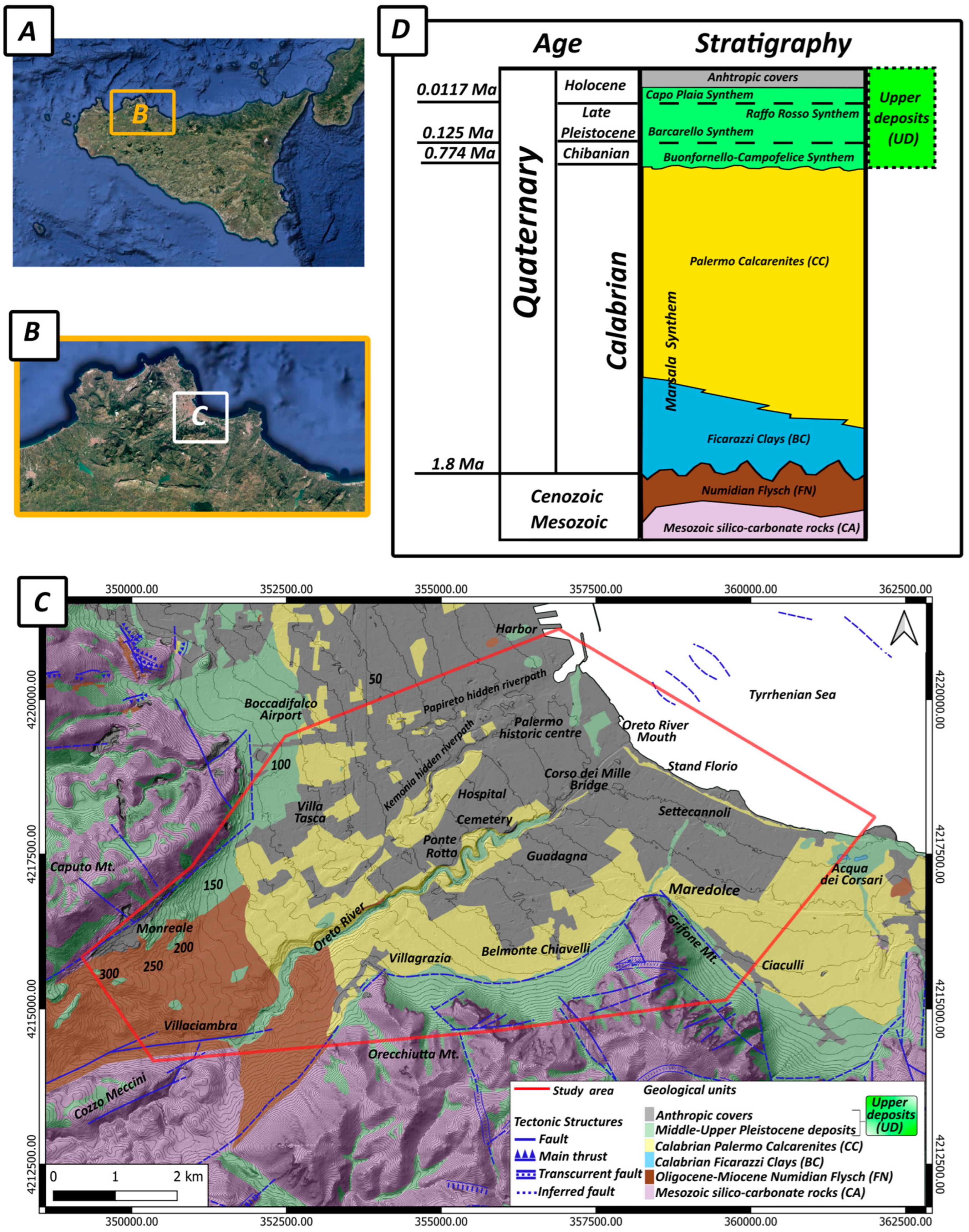
2.1. Geological Features of the Palermo Plain
2.2. Velocities of Shear Waves Within the Palermo Plain Deposits
3. Materials and Methods
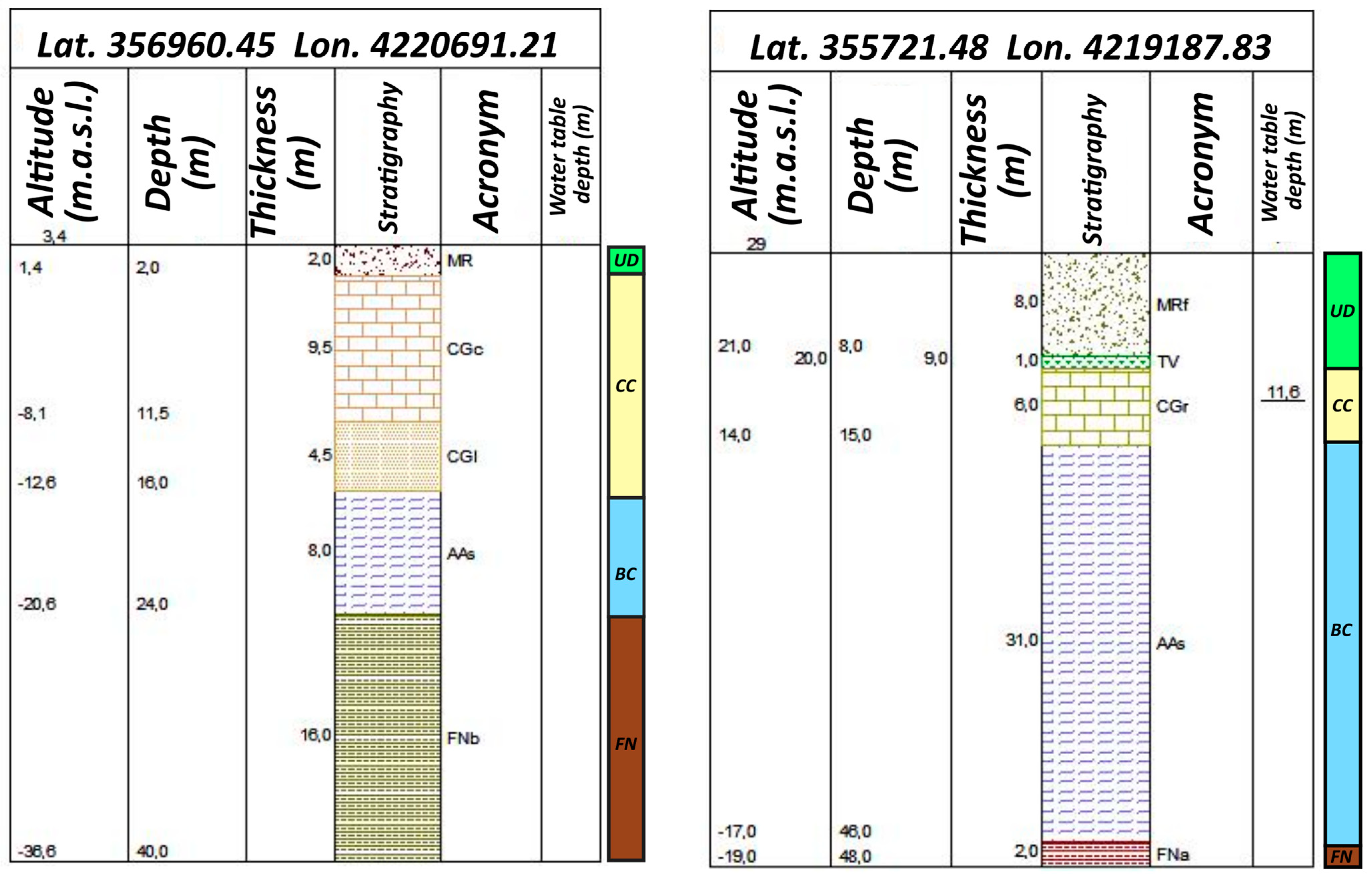
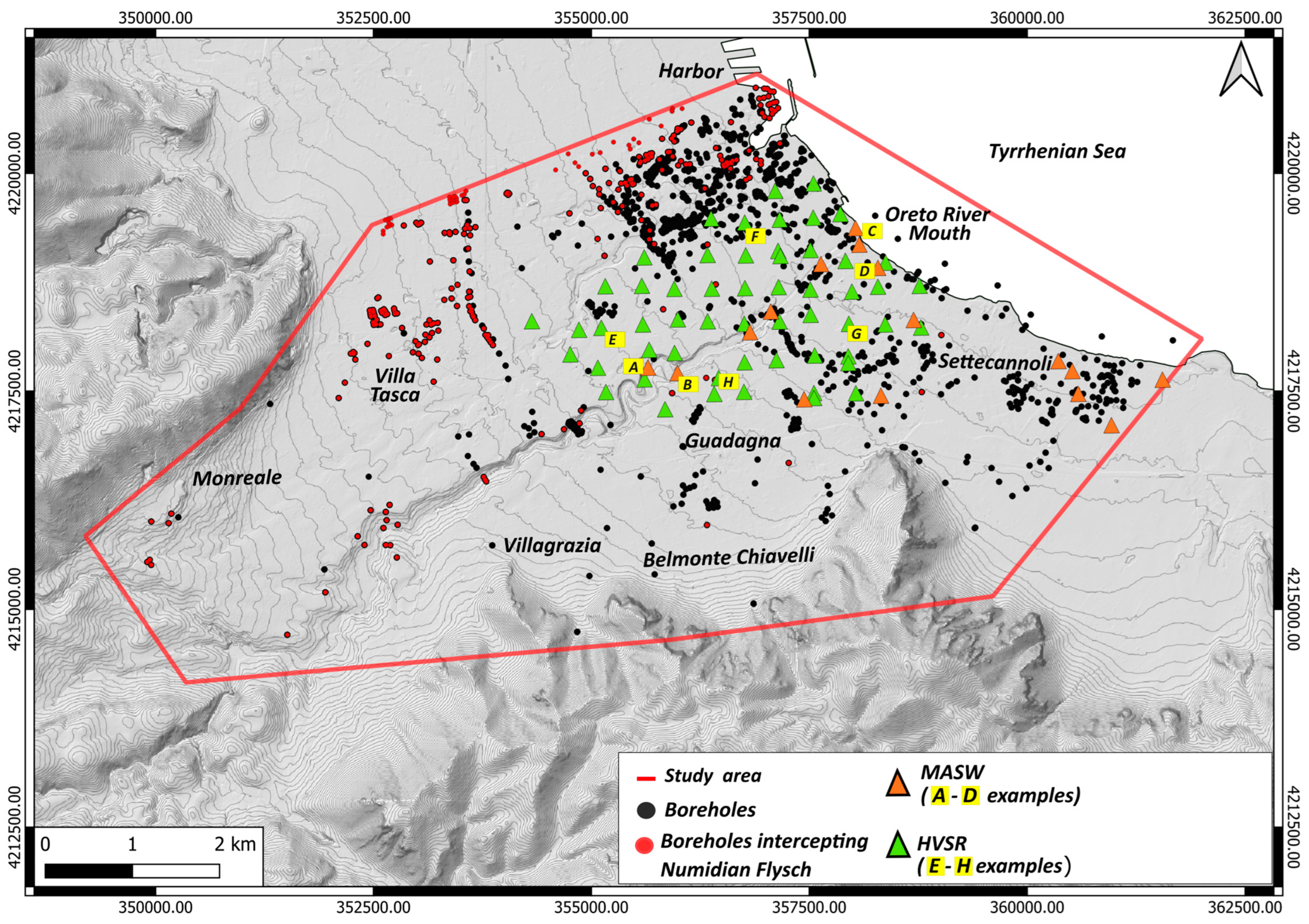
3.1. Boreholes
3.2. Environmental Noise Acquisition
3.3. Active Seismic Survey
4. Results and Discussion
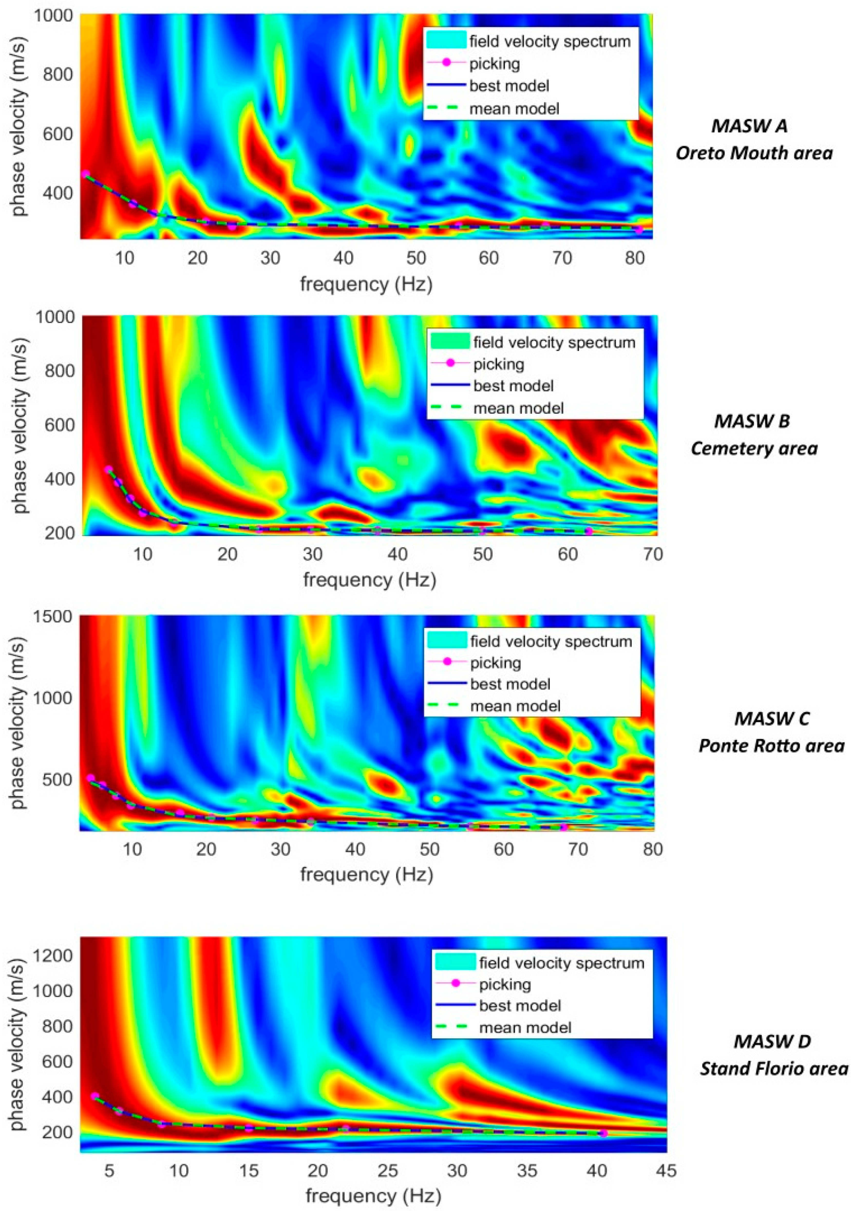
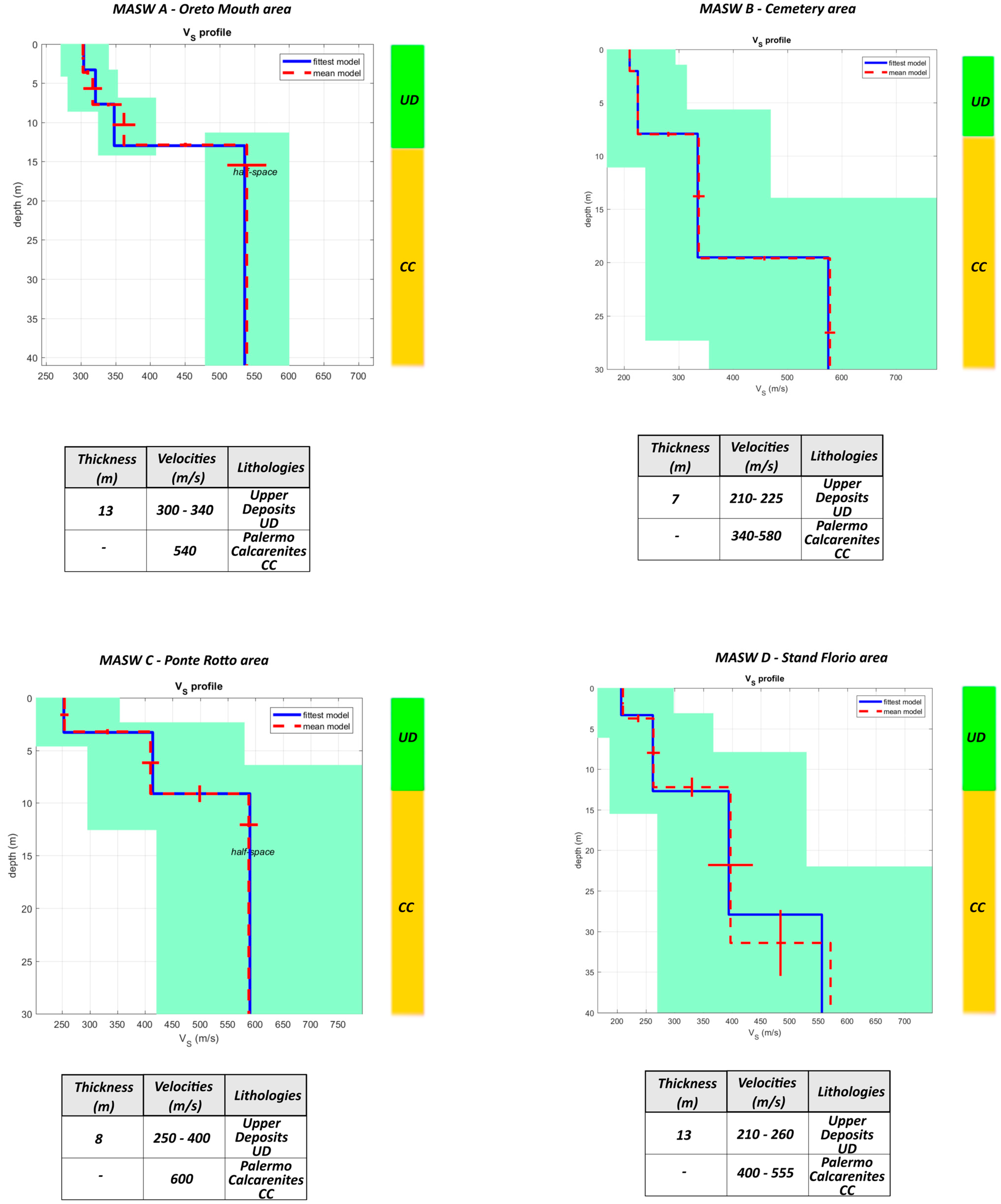
4.1. MASW Analysis
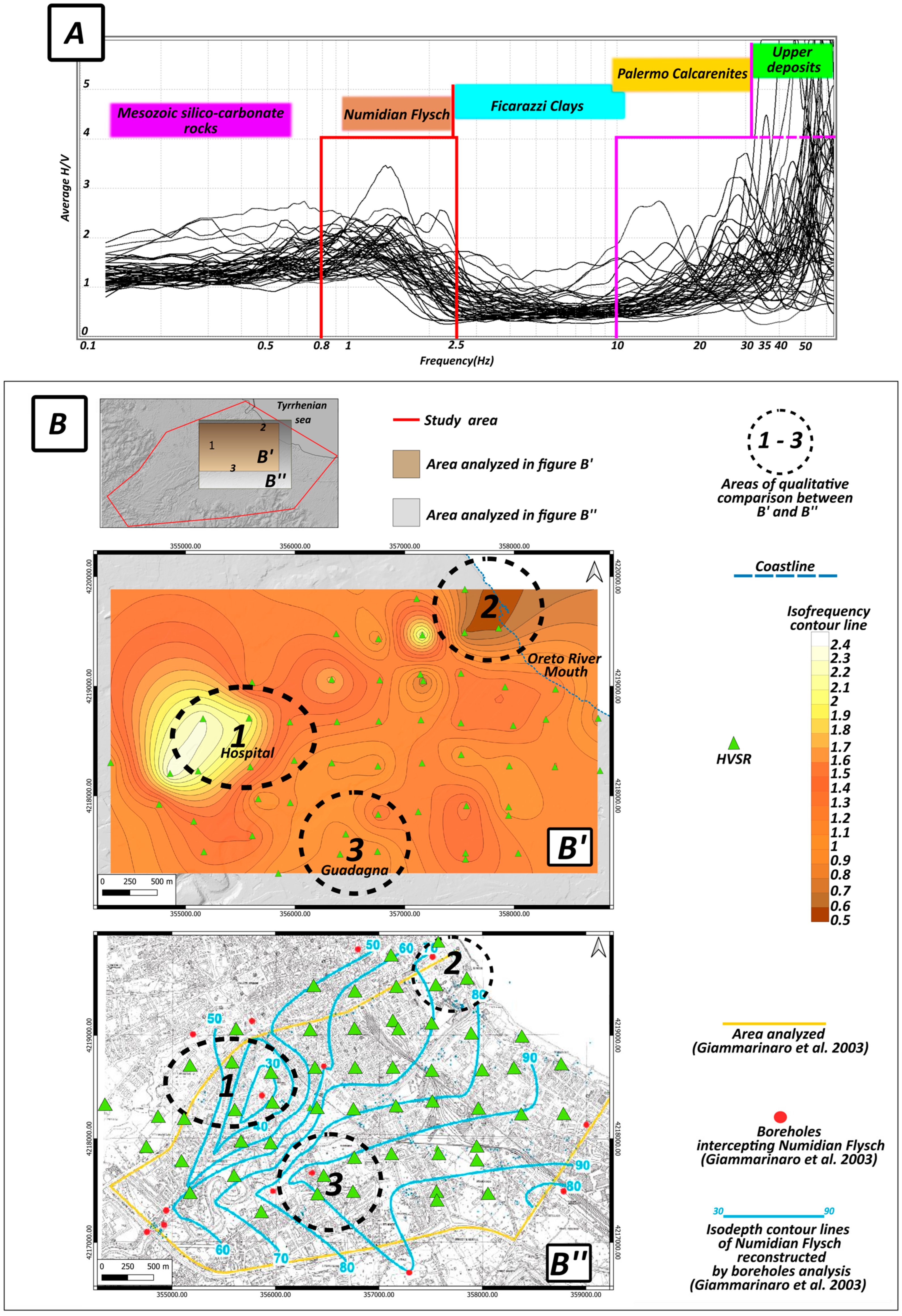
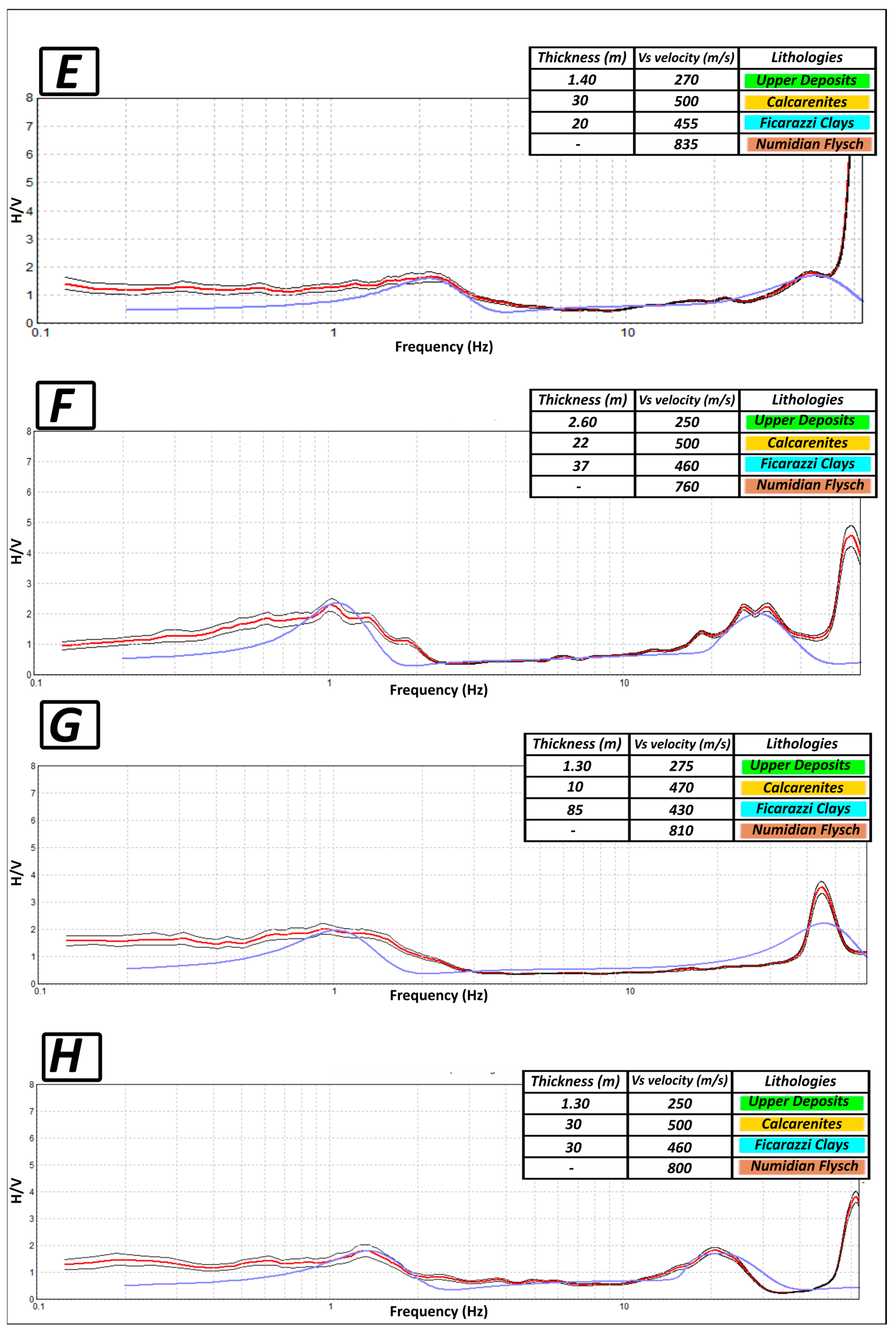
4.2. HVSR Qualitative Analysis and Inversion into Subsoil Velocity Models
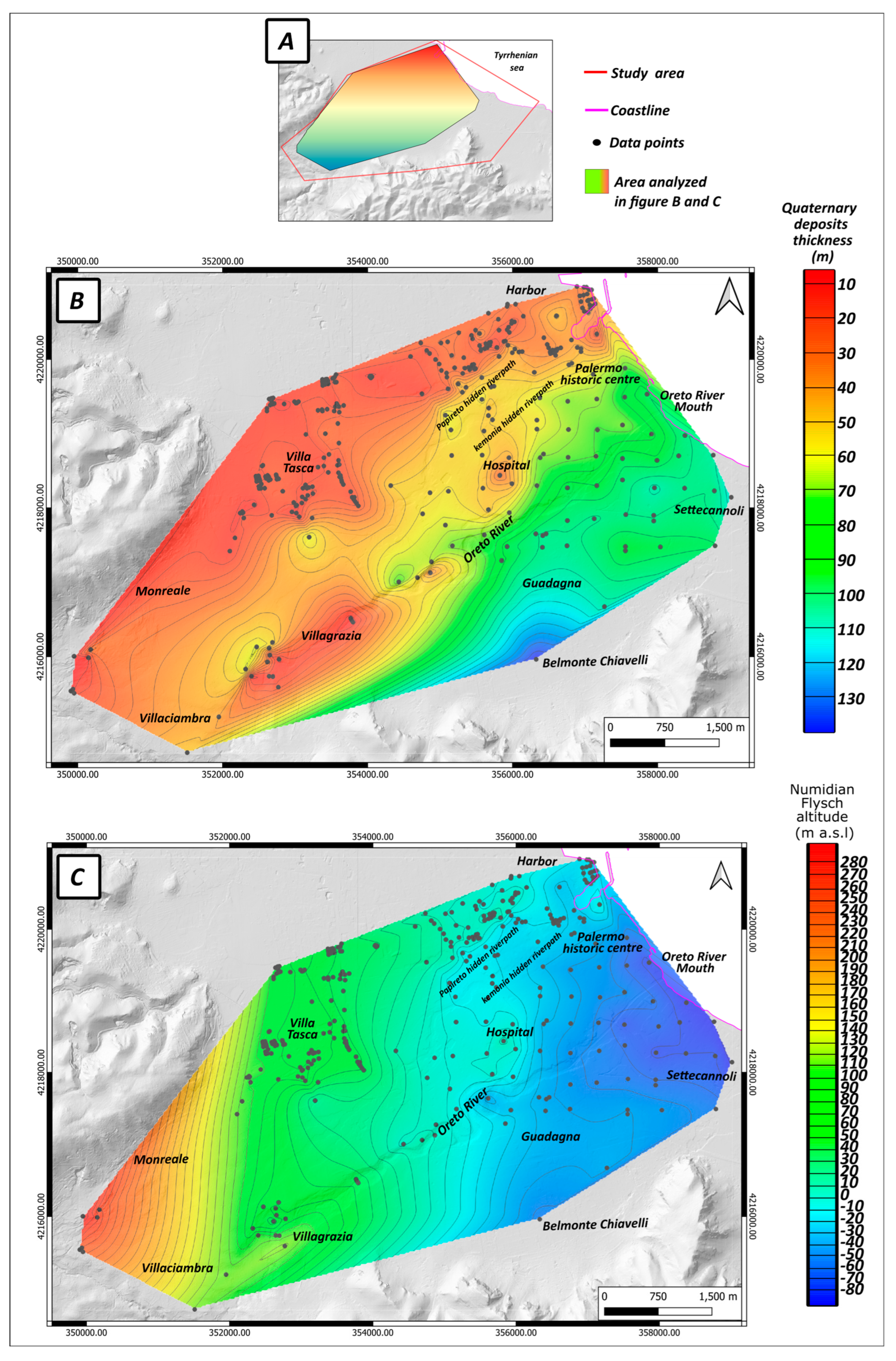
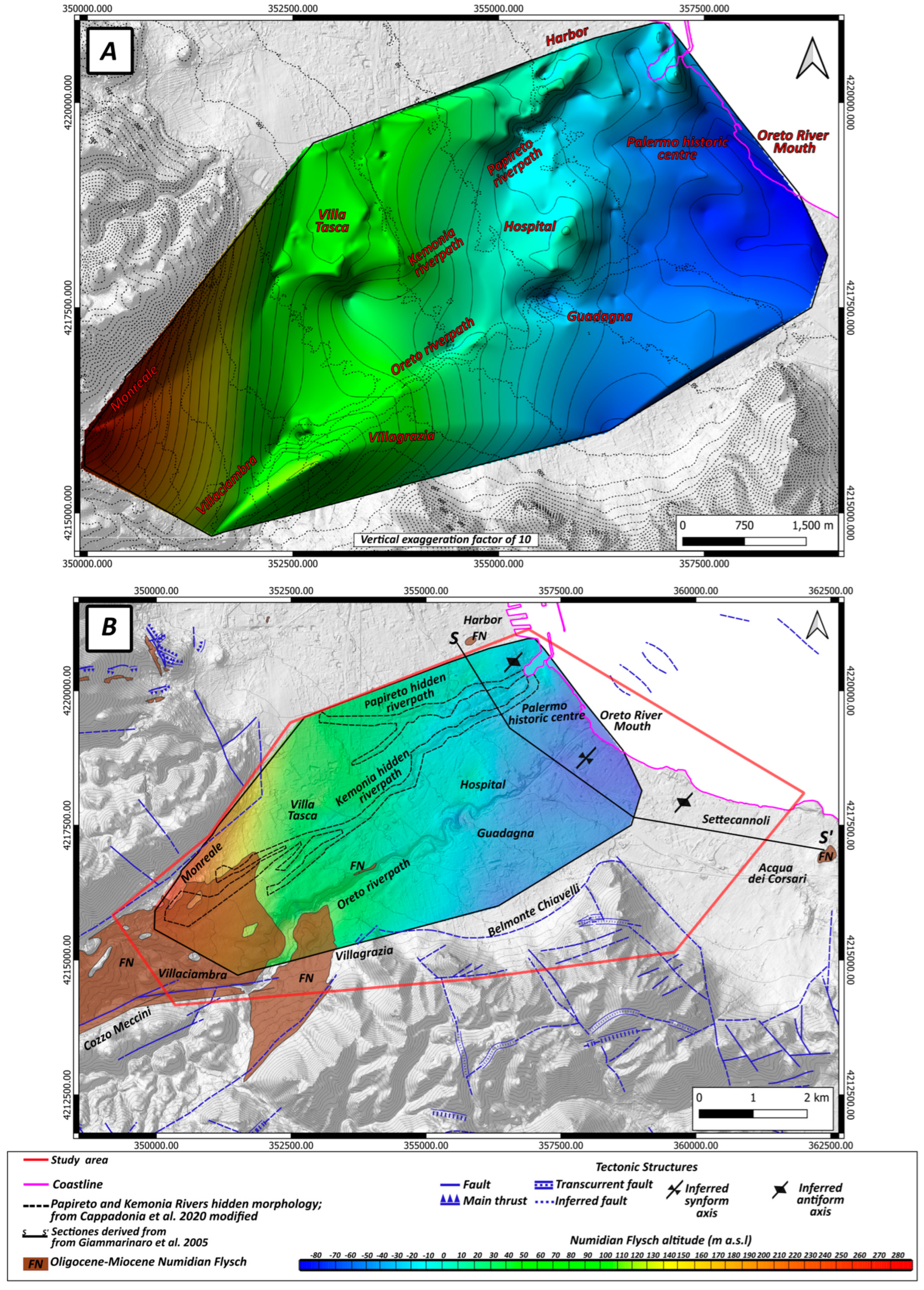
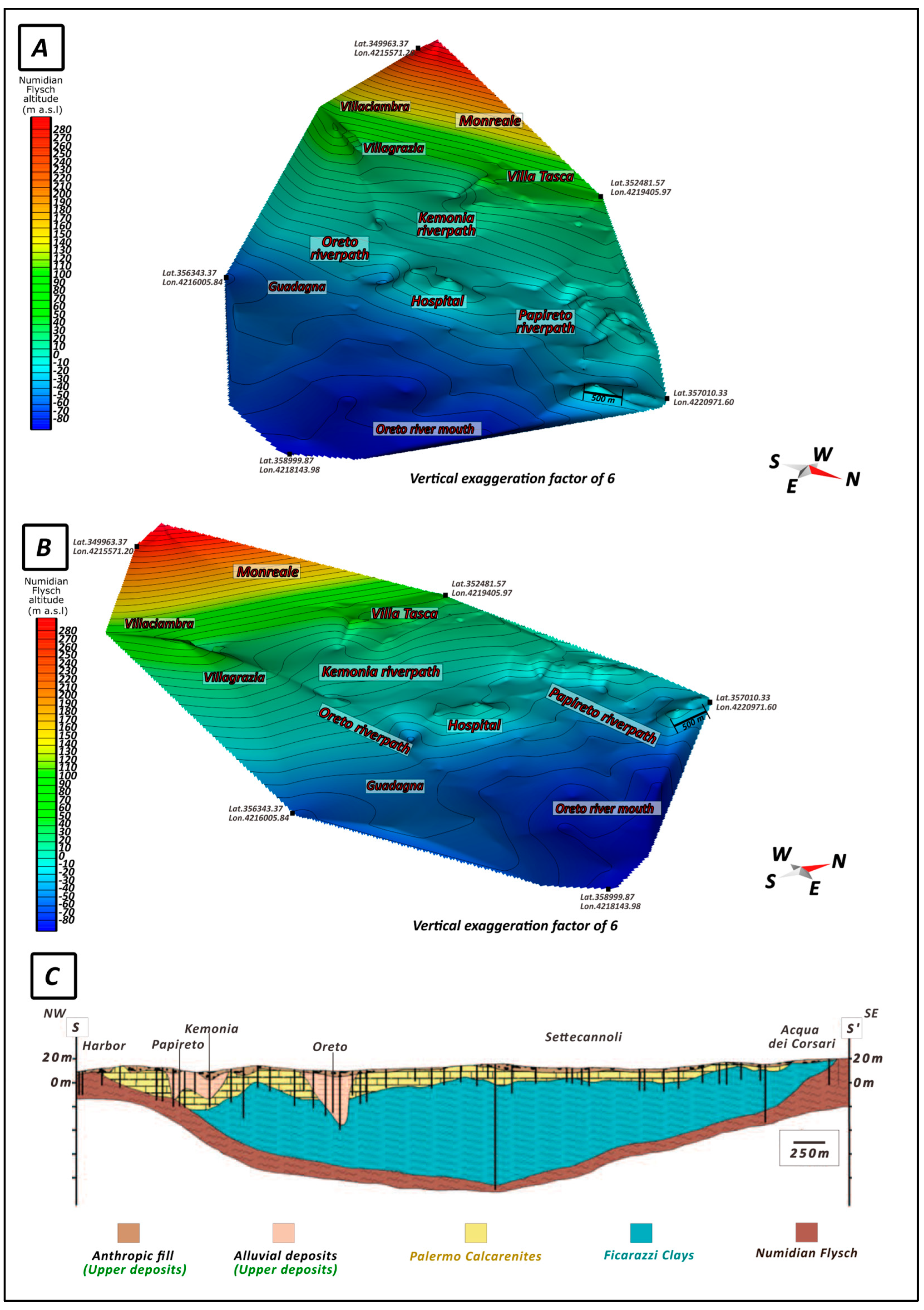
4.3. Reconstruction of the Numidian Flysch Surface Model
4.4. Analysis of the 3D Model of the Numidian Flysch Top Surface
5. Conclusions
Author Contributions
Funding
Data Availability Statement
Conflicts of Interest
References
- Royal, A.C.; Atkins, P.R.; Brennan, M.J.; Chapman, D.N.; Chen, H.; Cohn, A.G.; Goddard, K.Y.; Hayes, R.; Hao, T.; Lewin, P.L.; et al. Site Assessment of Multiple-Sensor Approaches for Buried Utility Detection. Int. J. Geophys. 2011, 1, 496123. [Google Scholar] [CrossRef]
- Plati, C.; Loizos, A.; Gkyrtis, K. Assessment of modern roadways using non-destructive geophysical surveying techniques. Surv. Geophys. 2020, 41, 395–430. [Google Scholar] [CrossRef]
- Santos, E.A.N.E.; Dutra, C.T.D.S.; Chinelli, C.K.; Hammad, A.W.; Haddad, A.N.; Soares, C.A. The main impacts of infrastructure works on public roads. Infrastructures 2021, 6, 118. [Google Scholar] [CrossRef]
- Rizzo, E.; Capozzoli, L.; De Martino, G.; Grimaldi, S. Urban geophysical approach to characterize the subsoil of the main square in San Benedetto del Tronto town (Italy). Eng. Geol. 2019, 257, 105133. [Google Scholar] [CrossRef]
- Andersen, T.R.; Poulsen, S.E.; Pagola, M.A.; Medhus, A.B. Geophysical mapping and 3D geological modelling to support urban planning: A case study from Vejle, Denmark. J. Appl. Geophys. 2020, 180, 104130. [Google Scholar] [CrossRef]
- Ksit, B.; Pilch, R. Dependence of Underground Infrastructure and Land Management in Urbanized Areas. Civ. Environ. Eng. Rep. 2021, 31, 85–98. [Google Scholar] [CrossRef]
- Gutierrez, I.; Weibull, W.; Watson, L.; Olsen, T.M.; Escalona, A. Holistic 3D model of an urban area in Norway: An integration of geophysical, geotechnical, remote sensing, and geological methods. Remote Sens. 2023, 15, 2872. [Google Scholar] [CrossRef]
- Innocenti, A.; Rosi, A.; Tofani, V.; Pazzi, V.; Gargini, E.; Masi, E.B.; Segoni, S.; Bertolo, D.; Paganone, M.; Casagli, N. Geophysical surveys for geotechnical model reconstruction and slope stability modelling. Remote Sens. 2023, 15, 2159. [Google Scholar] [CrossRef]
- Birgören, G.; Özel, O.; Siyahi, B. Bedrock depth mapping of the coast south of Istanbul: Comparison of analytical and experimental analyses. Turk. J. Earth Sci. 2009, 18, 315–329. [Google Scholar] [CrossRef]
- Kühn, D.; Ohrnberger, M.; Dahm, T. Imaging a shallow salt diapir using ambient seismic vibrations beneath the densely built-up city area of Hamburg, Northern Germany. J. Seismol. 2011, 15, 507–531. [Google Scholar] [CrossRef]
- Busato, L.; Boaga, J.; Peruzzo, L.; Himi, M.; Cola, S.; Bersan, S.; Cassiani, G. Combined geophysical surveys for the characterization of a reconstructed river embankment. Eng. Geol. 2016, 211, 74–84. [Google Scholar] [CrossRef]
- Bora, N.; Biswas, R.; Malischewsky, P. Imaging subsurface structure of an urban area based on diffuse-field theory concept using seismic ambient noise. Pure Appl. Geophys. 2020, 177, 4733–4753. [Google Scholar] [CrossRef]
- Luberti, G.M.; Prestininzi, A.; Esposito, C. Development of a geological model useful for the study of the natural hazards in urban environments: An example from the eastern sector of Rome (Italy). Ital. J. Eng. Geol. Environ. 2015, 2, 41–62. [Google Scholar] [CrossRef]
- Esposito, C.; Belcecchi, N.; Bozzano, F.; Brunetti, A.; Marmoni, G.M.; Mazzanti, P.; Romeo, S.; Camillozzi, F.; Cecchini, G.; Spizzirri, M. Integration of satellite-based A-DInSAR and geological modeling supporting the prevention from anthropogenic sinkholes: A case study in the urban area of Rome. Geomat. Nat. Hazards Risk 2021, 12, 2835–2864. [Google Scholar] [CrossRef]
- Guo, J.; Wang, X.; Wang, J.; Dai, X.; Wu, L.; Li, C.; Li, F.; Liu, S.; Jessell, M.W. Three-dimensional geological modeling and spatial analysis from geotechnical borehole data using an implicit surface and marching tetrahedra algorithm. Eng. Geol. 2021, 284, 106047. [Google Scholar] [CrossRef]
- Pica, A.; Lämmle, L.; Burnelli, M.; Del Monte, M.; Donadio, C.; Faccini, F.; Lazzari, M.; Mandarino, A.; Melelli, L.; Perez Filho, A.; et al. Urban geomorphology methods and applications as a guideline for understanding the city environment. Land 2024, 13, 907. [Google Scholar] [CrossRef]
- Cappadonia, C.; Di Maggio, C.; Agate, M.; Agnesi, V. Geomorphology of the urban area of Palermo (Italy). J. Maps 2020, 16, 274–284. [Google Scholar] [CrossRef]
- Agnesi, V. (Ed.) La Geomorfologia di Palermo; Sapienza Università Editrice: Rome, Italy, 2021; Volume 24, ISBN 978-88-9377-168-9. [Google Scholar]
- Di Matteo, S. Palermo: Storia Della Città: Dalle Origini ad Oggi; Kalos: Lumiose City, France, 2002. [Google Scholar]
- Coroneo, R. Storia del Porto di Palermo; Clausi, M., Ed.; AdSP del Mare di Sicilia Occidentale: Porto Empedocle, Italy, 2011. [Google Scholar]
- Columba, G.M. Per la topografia antica di Palermo. In Centenario Della Nascita di Michele Amari; Cozzo, G.S., Ed.; Stabilimento Tipografico Virzì: Palermo, Italy, 1910; Volume II, pp. 395–426. [Google Scholar]
- Brandolini, P.; Cappadonia, C.; Luberti, G.M.; Donadio, C.; Stamatopoulos, L.; Di Maggio, C.; Faccini, F.; Stanislao, C.; Vergari, F.; Paliaga, G.; et al. Geomorphology of the Anthropocene in Mediterranean urban areas. Prog. Phys. Geogr. Earth Environ. 2020, 44, 461–494. [Google Scholar] [CrossRef]
- Barbera, G. Conca d’Oro; Sellerio: Palermo, Italy, 2012. [Google Scholar]
- Guidoboni, E.; Mariotti, D.; Giammarinaro, M.S.; Rovelli, A. Identification of amplified damage zones in Palermo, Sicily (Italy), during the earthquakes of the last three centuries. Bull. Seismol. Soc. Am. 2003, 93, 1649–1669. [Google Scholar] [CrossRef]
- Di Giulio, G.; Azzara, R.M.; Cultrera, G.; Giammarinaro, M.S.; Vallone, P.; Rovelli, A. Effect of local geology on ground motion in the city of Palermo, Italy, as inferred from aftershocks of the 6 September 2002 M w 5.9 earthquake. Bull. Seismol. Soc. Am. 2005, 95, 2328–2341. [Google Scholar] [CrossRef]
- Giammarinaro, M.S.; Tertulliani, A.; Galli, G.; Leta, M. Investigation of surface geology and intensity variability in the Palermo, Italy, urban area after the 6 September 2002 earthquake. Bull. Seismol. Soc. Am. 2005, 95, 2318–2327. [Google Scholar] [CrossRef]
- Giammarinaro, M.S.; Barba, D.; Cionco, D.; Contino, A.; Vallone, P. Site effects assessment through historical and instrumental data integration. Quad. Del Mus. Geol. G. G. Gemmellaro 2006, 9, 170–177. [Google Scholar]
- Cusimano, G. Le Alluvioni Palermitane: Cronologia e Cause, dal 934 al 1988. [Univ.]; Dipartimento di Geologia e Geodesia: Palermo, Italy, 1989. [Google Scholar]
- Agnesi, V. La Valle dell’Oreto. Lineamenti di Geologia Ambientale; Uomo e Territorio: Palermo, Italy, 1995; Volume 7, pp. 25–45. [Google Scholar]
- Francipane, A.; Pumo, D.; Sinagra, M.; La Loggia, G.; Noto, L.V. A paradigm of extreme rainfall pluvial floods in complex urban areas: The flood event of 15 July 2020 in Palermo (Italy). Nat. Hazards Earth Syst. Sci. Discuss. 2021, 21, 2563–2580. [Google Scholar] [CrossRef]
- Bosco, G. Analisi preliminare della risposta dinamica locale del sottosuolo di Palermo. Riv. Ital. Geotec. 1984, 1, 23–35. [Google Scholar]
- Giammarinaro, M.S.; Canzoneri, V.; Vallone, P.; Zuccarello, A. Effects of the 6th September 2002 earthquake: Damage amplification in the south-eastern sector of Palermo explained by GIS technology. Ann. Geophys. 2003, 46, 1195–1207. [Google Scholar] [CrossRef]
- Todaro, P. Il rischio sismico nel centro storico di Palermo: Rigidità sismica e modelli geologici semplificati per terreni di sedime di fondazioni datate. In Archeometria Del Costruito. L’edificato Storico: Materiali, Strutture e Rischio Sismico; Edipuglia s.r.l.: Bari, Italy, 2006; pp. 239–255. [Google Scholar]
- Cusimano, G.; De Maio, M.; Gatto, L.; Hauser, S.; Pisciotta, A. Application of SINTACS method to the aquifers of Piana di Palermo, Sicily, Italy. Geofís. Int. 2004, 43, 661–670. [Google Scholar] [CrossRef]
- Lofrano, G.; Carotenuto, M.; Maffettone, R.; Todaro, P.; Sammataro, S.; Kalavrouziotis, I.K. Water collection and distribution systems in the Palermo Plain during the Middle Ages. Water 2013, 5, 1662–1676. [Google Scholar] [CrossRef]
- Candela, E.G.; Pecoraino, G.; Morici, S.; La Pica, L. Regulatory Framework—Water for Drinking Purposes. In Drinking Water in Sicily: Hydrogeological and Hydrogeochemical Aspects; Springer Int. Publishing: Cham, Switzerland, 2024; pp. 1–37. [Google Scholar] [CrossRef]
- Canzoneri, A.; Capizzi, P.; Martorana, R.; Albano, L.; Bonfardeci, A.; Costa, N.; Favara, R. Geophysical Constraints to Reconstructing the Geometry of a Shallow Groundwater Body in Caronia (Sicily). Water 2023, 15, 3206. [Google Scholar] [CrossRef]
- Agate, M.; Basilone, L.; Di Maggio, C.; Contino, A.; Pierini, S.; Catalano, R. Quaternary marine and continental unconformity-bounded stratigraphic units of the NW Sicily coastal belt. J. Maps 2017, 13, 425–437. [Google Scholar] [CrossRef]
- Catalano, R.; Valenti, V.; Albanese, C.; Accaino, F.; Sulli, A.; Tinivella, U.; Gasparo Morticelli, M.; Zanolla, C.; Giustiniani, M. Sicily’s fold–thrust belt and slab roll-back: The SI. RI. PRO. seismic crustal transect. J. Geol. Soc. 2013, 170, 451–464. [Google Scholar] [CrossRef]
- Catalano, R.; Basilone, L.; Di Maggio, C.; Gasparo Morticelli, M.; Agate, M.; Avellone, G.; Mancuso, M.; Contino, A.; Valenti, V.; Vaccaro, F.; et al. Note Illustrative Della Carta Geologica d’Italia Alla Scala 1:50.000 del Foglio 594–585 “Partinico-Mondello.”. Progetto CARG Dip di Geol e Geod Univ. di Palermo. 2013. Available online: https://iris.unipa.it/handle/10447/100586 (accessed on 1 March 2023).
- Catalano, R.; Avellone, G.; Basilone, L.; Contino, A.; Agate, M.; Di Maggio, C.; Sulli, A.; Gasparo Morticelli, M.; Albanese, C.; Vattano, M.; et al. Carta Geologica D’italia Alla Scala 1:50.000 e Note Illustrative del Foglio 595_Palermo; Progetto CARG Dip di Geol e Geod Univ. di Palermo, ISPRA: Rome, Italy, 2013. [Google Scholar]
- Incarbona, A.; Contino, A.; Agate, M.; Bonomo, S.; Calvi, F.; Di Stefano, E.; Giammarinaro, M.S.; Priulla, A.; Sprovieri, R. Biostratigraphy, chronostratigraphy and paleonvironmental reconstruction of the Palermo historical centre Quaternary succession. Ital. J. Geosci. 2016, 135, 512–525. [Google Scholar] [CrossRef]
- Basilone, L.; Di Maggio, C. Geology of Monte Gallo (Palermo Mts, NW Sicily). J. Maps 2016, 12, 1072–1083. [Google Scholar] [CrossRef]
- Ruggieri, G.; Sprovieri, R. Ricerche sul Siciliano di Palermo: Le argille del fiume Oreto. Boll. Soc. Geol. Ital. 1977, 94, 1613–1622. Available online: http://pascal-francis.inist.fr/vibad/index.php?action=getRecordDetail&idt=PASCALGEODEBRGM7820251877 (accessed on 1 March 2023).
- Ruggieri, G. Una trasgressione del Pleistocene inferiore nella Sicilia occidentale. Il Nat. Siciliano. 1978, 5, 3–4. [Google Scholar]
- Agate, M.; Beranzoli, L.; Braun, T.; Catalano, R.; Favalli, P.; Frugoni, F.; Pepe, F.; Smriglio, G.; Sulli, A. The 1998 offshore NW Sicily earthquakes in the tectonic framework of the southern border of the Tyrrhenian Sea. Mem. Soc. Geol. It. 2000, 55, 103–114. [Google Scholar]
- Martorana, R.; Agate, M.; Capizzi, P.; Cavera, F.; D’Alessandro, A. Seismo-stratigraphic model of “La Bandita” area in the Palermo Plain (Sicily, Italy) through HVSR inversion constrained by stratigraphic data. Ital. J. Geosci. 2018, 137, 73–86. [Google Scholar] [CrossRef]
- Cafiso, F.; Canzoneri, A.; Capizzi, P.; Carollo, A.; Martorana, R.; Romano, F. Joint interpretation of electrical and seismic data aimed at modelling the foundation soils of the Maredolce monumental complex in Palermo (Italy). Archaeol. Prospect. 2023, 30, 69–85. [Google Scholar] [CrossRef]
- Contino, A.; Giammarinaro, M.S.; Vallone, P.; Varsalona, S.; Zuccarello, A. Analisi stratigrafico geotecnica del settore meridionale della città di Palermo finalizzata alla caratterizzazione di fattori di pericolosità sismica in esso presenti. Bull. Soc. Geol. Ital. 2006, 125, 329. [Google Scholar]
- Giammarinaro, M.S.; Guidoboni, E.; Maiorana, S.; Rovelli, A. A GIS system as a tool for the integrated analysis of geological data and seismic effects: Historic centre of Palermo. In IEEE/ISPRS Joint Workshop on Remote Sens. and Data Fusion over Urban Areas (Cat. No.01EX482); IEEE: New York, NY, USA, 2001; pp. 288–292. [Google Scholar] [CrossRef]
- Canzoneri, V.; Giammarinaro, M.S.; Gugliuzza, G.; Vallone, P. Area urbana palermitana: Analisi delle proprietà geotecniche dei terreni supportata da tecnologia GIS. In XXI Convegno Nazionale di Geotecnica; Patreon Ed. Bologna: L’Aquila, Italy, 2002; pp. 37–44. [Google Scholar]
- Nakamura, Y. A method for dynamic characteristics estimation of subsurface using microtremor on the ground surface. Railw. Tech. Res. Inst. Q. Rep. 1989, 30, 25–33. Available online: https://www.sdr.co.jp/papers/hv_1989.pdf (accessed on 1 May 2025).
- Lermo, J.; Chávez-García, F.J. Are microtremors useful in site response evaluation? BSSA 1994, 84, 1350–1364. [Google Scholar]
- Fäh, D.; Kind, F.; Giardini, D. A theoretical investigation of average H/V ratios. GJI 2001, 145, 535–549. [Google Scholar] [CrossRef]
- Malischewsky, P.G.; Scherbaum, F. Love’s formula and H/V-ratio (ellipticity) of Rayleigh waves. Wave Motion 2004, 40, 57–67. [Google Scholar] [CrossRef]
- Arai, H.; Tokimatsu, K. S-wave velocity profiling by inversion of microtremor H/V spectrum. BSSA 2004, 94, 53–63. [Google Scholar] [CrossRef]
- Herak, M. Model HVSR—A Matlab® tool to model horizontal-to-vertical spectral ratio of ambient noise. Comput. Geosci. 2008, 34, 1514–1526. [Google Scholar] [CrossRef]
- Van Der Baan, M. The origin of SH-wave resonance frequencies in sedimentary layers. GJI 2009, 178, 1587–1596. [Google Scholar] [CrossRef]
- Tuan, T.T.; Scherbaum, F.; Malischewsky, P.G. On the relationship of peaks and troughs of the ellipticity (H/V) of Rayleigh waves and the transmission response of single layer over half-space models. GJI 2011, 184, 793–800. [Google Scholar] [CrossRef]
- Molnar, S.; Cassidy, J.F.; Castellaro, S.; Cornou, C.; Crow, H.; Hunter, J.A.; Matsushima, S.; Sánchez-Sesma, F.J.; Yong, A. Application of microtremor horizontal-to-vertical spectral ratio (MHVSR) analysis for site characterization: State of the art. Surv. Geophys. 2018, 39, 613–631. [Google Scholar] [CrossRef]
- Nogoshi, M.; Igarashi, T. On the amplitude characteristics of microtremor (Part 2). J. Seismol. Soc. JPN 1971, 24, 26–40, (In Japanese with English abstract). [Google Scholar] [CrossRef]
- Nakamura, Y. Real-time information systems for seismic hazards mitigation UrEDAS, HERAS and PIC. Q. Rep.-Rtri 1996, 37, 112–127. [Google Scholar]
- Nakamura, Y. Basic structure of QTS (HVSR) and examples of applications. In Increasing Seismic Safety by Combining Engineering Technologies and Seismological Data; Springer: Dordrecht, The Netherlands, 2009; pp. 33–51. Available online: https://link.springer.com/chapter/10.1007/978-1-4020-9196-4_4 (accessed on 1 March 2023).
- Xu, R.; Wang, L. The horizontal-to-vertical spectral ratio and its applications. EURASIP J. Adv. Signal Process 2021, 75. [Google Scholar] [CrossRef]
- Toni, M.; El Rayess, M.; Hafiez, H.A. Local site characteristics and earthquake ground motion parameters around the Nile River, south of Cairo, Egypt. J. App. Geophys. 2022, 197, 104528. [Google Scholar] [CrossRef]
- Lachet, C.; Bard, P.Y. Numerical and theoretical investigations on the possibilities and limitations of Nakamura’s technique. J. Phys. Earth 1994, 42, 377–397. [Google Scholar] [CrossRef]
- Ibs-von Seht, M.; Wohlenberg, J. Microtremor measurements used to map thickness of soft sediments. BSSA 1999, 89, 250–259. [Google Scholar] [CrossRef]
- Fäh, D.; Kind, F.; Giardini, D. Inversion of local S wave velocity structures from average H/V ratios, and their use for the estimation of site-effects. J. Seismol. 2003, 7, 449–467. [Google Scholar] [CrossRef]
- Bignardi, S.; Yezzi, A.J.; Fiussello, S.; Comelli, A. OpenHVSR—Processing toolkit: Enhanced HVSR processing of distributed microtremor measurements and spatial variation of their informative content. Comput. Geosci. 2018, 120, 10–20. [Google Scholar] [CrossRef]
- Molnar, S.; Sirohey, A.; Assaf, J.; Bard, P.Y.; Castellaro, S.; Cornou, C.; Cox, B.; Guillier, B.; Hassani, B.; Kawase, H.; et al. A review of the microtremor horizontal-to-vertical spectral ratio (MHVSR) method. J. Seismol. 2022, 26, 653–685. [Google Scholar] [CrossRef] [PubMed]
- Gabàs, A.; Macau, A.; Benjumea, B.; Bellmunt, F.; Figueras, S.; Vilà, M. Combination of geophysical methods to support urban geological mapping. Surv. Geophys. 2014, 35, 983–1002. [Google Scholar] [CrossRef]
- Martorana, R.; Capizzi, P.; Avellone, G.; D’Alessandro, A.; Siragusa, R.; Luzio, D. Assessment of a geological model by surface wave analyses. J. Geophys. Eng. 2017, 14, 159–172. [Google Scholar] [CrossRef]
- Meneisy, A.M.; Toni, M.; Omran, A.A. Soft sediment characterization using seismic techniques at Beni Suef city, Egypt. JEEG 2020, 25, 391–401. [Google Scholar] [CrossRef]
- Stanko, D.; Markušić, S. An empirical relationship between resonance frequency, bedrock depth and VS 30 for Croatia based on HVSR forward modelling. Nat. Hazards 2020, 103, 3715–3743. [Google Scholar] [CrossRef]
- Capizzi, P.; Martorana, R. Analysis of HVSR Data Using a Modified Centroid-Based Algorithm for Near-Surface Geological Reconstruction. Geosciences 2022, 12, 147. [Google Scholar] [CrossRef]
- Capizzi, P.; Martorana, R.; Canzoneri, A.; Bonfardeci, A.; Favara, R. Coastal Groundwater Bodies Modelling Using Geophysical Surveys: The Reconstruction of the Geometry of Alluvial Plains in the North-Eastern Sicily (Italy). Water 2024, 16, 1048. [Google Scholar] [CrossRef]
- Sesame, W. Site effects assessment using ambient excitations. In Optimum Deployment Strategy for Array Measurements; European Commission-Research General Directorate Project No. EVG1 CT, 26; European Commission-Research General Directorate: Brussels, Belgium, 2000. [Google Scholar]
- Mucciarelli, M.; Gallipoli, M.R.; Arcieri, M. The stability of the horizontal-to-vertical spectral ratio of triggered noise and earthquake recordings. BSSA 2003, 93, 1407–1412. [Google Scholar] [CrossRef]
- Jongmans, D.; Ohrnberger, M.; Wathelet, M. Recommendations for Quality Array Measurements and Processing. Report WP13, SESAME (Site Effects Assessment Using Ambient Excitations), European Commission, Brussels, 35 p. 2005. Available online: http://sesame.geopsy.org/Delivrables/Del-D24-Wp13.pdf (accessed on 1 March 2023).
- Park, C.B.; Miller, R.D.; Xia, J.; Ivanov, J. Multichannel seismic surface-wave methods for geotechnical applications. In Proceedings of the First International Conference on the Application of Geophysical Methodologies to Transportation Facilities and Infrastructure, St. Louis, MO, USA, 11–15 December 2000; pp. 11–15. [Google Scholar]
- Xia, J.; Miller, R.D.; Park, C.B.; Ivanov, J. Construction of 2-D vertical shear-wave velocity field by the multichannel analysis of surface wave technique. In Proceedings of the 13th EEGS Symposium on the Application of Geophysics to Engineering and Environmental Problems, Arlington, VA, USA, 20–24 February 2000; European Association of Geoscientists & Engineers: Bunnik, The Netherlands, 2000; pp. 1197–1206. [Google Scholar] [CrossRef]
- Xia, J. Estimation of near-surface shear-wave velocities and quality factors using multichannel analysis of surface-wave methods. J. Appl. Geophys. 2014, 103, 140–151. [Google Scholar] [CrossRef]
- Foti, S.; Hollender, F.; Garofalo, F.; Albarello, D.; Asten, M.; Bard, P.Y.; Comina, C.; Cornou, C.; Cox, B.; Di Giulio, G.; et al. Guidelines for the good practice of surface wave analysis: A product of the InterPACIFIC project. Bull. Earthq. Eng. 2018, 16, 2367–2420. [Google Scholar] [CrossRef]
- Miller, R.D.; Xia, J.; Park, C.B.; Ivanov, J.; Williams, E. Using MASW to map bedrock in Olathe, Kansas. In SEG Technical Program Expanded Abstracts 1999; Society of Exploration Geophysicists: Houston, TX, USA, 1999; pp. 433–436. [Google Scholar] [CrossRef]
- Watabe, Y.; Sassa, S. Application of MASW technology to identification of tidal flat stratigraphy and its geoenvironmental interpretation. Mar. Geol. 2008, 252, 79–88. [Google Scholar] [CrossRef]
- Panzera, F.; Lombardo, G. Seismic property characterization of lithotypes cropping out in the Siracusa urban area, Italy. Eng. Geol. Geol. 2013, 153, 12–24. [Google Scholar] [CrossRef]
- Jafri, N.J.S.; Ab Rahim, M.A.; Mohd Zahid, M.Z.A.; Bawadi, N.F.; Ahmad, M.M.; Mansor, A.F.; Wan Omar, W.M.S. Assessment of soil compaction properties based on surface wave techniques. In E3S Web of Conferences; EDP Sciences: Les Ulis, France, 2018; Volume 34, p. 01002. [Google Scholar] [CrossRef]
- Akkaya, İ.; Özvan, A. Site characterization in the Van settlement (Eastern Turkey) using surface waves and HVSR microtremor methods. J. App. Geophys. 2019, 160, 157–170. [Google Scholar] [CrossRef]
- Canzoneri, A.; Carollo, A.; Capizzi, P.; Majani, M.V.; Guastella, M.; Martorana, R. Seismic characterization and local seismic response analysis in urban areas: A case study of school sites in Palermo. In Proceedings of the GNGTS 2025, Bologna, Italy, 11–14 February 2025; Available online: https://gngts.ogs.it/scientific-program-2025/ (accessed on 6 May 2025).
- Mucciarelli, M. Reliability and applicability of Nakamura’s technique using microtremors: An experimental approach. J. Earthq. Eng. 1998, 2, 625–638. [Google Scholar] [CrossRef]
- Parolai, S.; Galiana-Merino, J.J. Effect of transient seismic noise on estimates of H/V spectral ratios. BSSA 2006, 96, 228–236. [Google Scholar] [CrossRef]
- Guillier, B.; Chatelain, J.L.; Bonnefoy-Claudet, S.; Haghshenas, E. Use of ambient noise: From spectral amplitude variability to H/V stability. J. Earthq. Eng. 2007, 11, 925–942. [Google Scholar] [CrossRef]
- Cara, F.; Di Giulio, G.; Milana, G.; Bordoni, P.; Haines, J.; Rovelli, A. On the stability and reproducibility of the horizontal-to-vertical spectral ratios on ambient noise: Case study of Cavola, Northern Italy. BSSA 2010, 100, 1263–1275. [Google Scholar] [CrossRef][Green Version]
- La Rocca, M.; Chiappetta, G.D.; Gervasi, A.; Festa, R.L. Non-stability of the noise HVSR at sites near or on topographic heights. Geophys. J. Int. 2020, 222, 2162–2171. [Google Scholar] [CrossRef]
- Castellaro, S.; Mulargia, F. VS30 Estimates Using Constrained H/V Measurements. BSSA 2009, 99, 761–773. [Google Scholar] [CrossRef]
- Dal Moro, G. Surface Wave Analysis for Near Surface Applications; Elsevier: Amsterdam, The Netherlands, 2014; ISBN 978-0-12800770-9. [Google Scholar]
- Castellaro, S. The complementarity of H/V and dispersion curves. Geophysics 2016, 81, T323–T338. [Google Scholar] [CrossRef]
- Parolai, S.; Picozzi, M.; Richwalski, S.M.; Milkereit, C. Joint inversion of phase velocity dispersion and H/V ratio curves from seismic noise recordings using a genetic algorithm, considering higher modes. Geophys. Res. Lett. 2005, 32, L01303. [Google Scholar] [CrossRef]
- Picozzi, M.; Parolai, S.; Richwalski, S.M. Joint inversion of H/V ratios and dispersion curves from seismic noise: Estimating the S-wave velocity of bedrock. Geophys. Res. Lett. 2005, 32, L11308. [Google Scholar] [CrossRef]
- Maresca, R.; Nardone, L.; Gizzi, F.T.; Potenza, M.R. Ambient noise HVSR measurements in the Avellino historical centre and surrounding area (southern Italy). Correlation with surface geology and damage caused by the 1980 Irpinia-Basilicata earthquake. Measurement 2018, 130, 211–222. [Google Scholar] [CrossRef]
- Abou Jaoude, R.; Makhoul, N.; Gesret, A.; Fleurisson, J.A. Numerical and Experimental Seismic Characterization of Byblos Site in Lebanon. Geosciences 2025, 15, 82. [Google Scholar] [CrossRef]
- Sambridge, M.; Braun, J.; McQueen, M. Computational methods for natural neighbor interpolation in two and three dimensions. In Proceedings of the Seventh Biennal Conference on Computational Techniques and Applications (CTAC 95), Melbourne, Australia, 3–5 July 1995; pp. 685–692. [Google Scholar] [CrossRef]
- Cueto, E.; Sukumar, N.; Calvo, B.; Martínez, M.A.; Cegonino, J.; Doblaré, M. Overview and recent advances in natural neighbour Galerkin methods. Arch. Comput. Methods Eng. 2003, 10, 307–384. [Google Scholar] [CrossRef]
- Avellone, G.; Barchi, M.R.; Catalano, R.; Morticelli, M.G.; Sulli, A. Interference between shallow and deep-seated structures in the Sicilian fold and thrust belt, Italy. J. Geol. Soc. 2010, 167, 109–126. [Google Scholar] [CrossRef]
- Caflisch, L. La geologia dei Monti di Palermo. Riv. It. Paleont. Strat. 1966, 12, 1–108. [Google Scholar]
- Agate, M.; Antonioli, F.; Caldareri, F.; Devoto, S.; Morticelli, M.G.; Sulli, A.; Parrino, N.; Furlani, S. Decoding Late Quaternary faulting through marine terraces and MIS 5.5 tilted tidal notches: Insights from central Mediterranean Sea (NW Sicily, Italy). Geomorphology 2025, 472, 109587. [Google Scholar] [CrossRef]
| Lithologies | Lower Vs Value (m/s) | Upper Vs Value (m/s) |
|---|---|---|
| Upper Triassic–Oligocene Carbonate (CA) | 700 | 1000 |
| Numidian Flysch (FN) | 450 | 1900 |
| Blue Clays (BC) | 100 | 1250 |
| Palermo Calcarenites (CC) | 100 | 1850 |
| Middle Pleistocene—Holocene “Upper deposits” (UD) | 60 | 450 |
Disclaimer/Publisher’s Note: The statements, opinions and data contained in all publications are solely those of the individual author(s) and contributor(s) and not of MDPI and/or the editor(s). MDPI and/or the editor(s) disclaim responsibility for any injury to people or property resulting from any ideas, methods, instructions or products referred to in the content. |
© 2025 by the authors. Licensee MDPI, Basel, Switzerland. This article is an open access article distributed under the terms and conditions of the Creative Commons Attribution (CC BY) license (https://creativecommons.org/licenses/by/4.0/).
Share and Cite
Canzoneri, A.; Martorana, R.; Agate, M.; Gasparo Morticelli, M.; Capizzi, P.; Carollo, A.; Sulli, A. Reconstruction of a 3D Bedrock Model in an Urban Area Using Well Stratigraphy and Geophysical Data: A Case Study of the City of Palermo. Geosciences 2025, 15, 174. https://doi.org/10.3390/geosciences15050174
Canzoneri A, Martorana R, Agate M, Gasparo Morticelli M, Capizzi P, Carollo A, Sulli A. Reconstruction of a 3D Bedrock Model in an Urban Area Using Well Stratigraphy and Geophysical Data: A Case Study of the City of Palermo. Geosciences. 2025; 15(5):174. https://doi.org/10.3390/geosciences15050174
Chicago/Turabian StyleCanzoneri, Alessandro, Raffaele Martorana, Mauro Agate, Maurizio Gasparo Morticelli, Patrizia Capizzi, Alessandra Carollo, and Attilio Sulli. 2025. "Reconstruction of a 3D Bedrock Model in an Urban Area Using Well Stratigraphy and Geophysical Data: A Case Study of the City of Palermo" Geosciences 15, no. 5: 174. https://doi.org/10.3390/geosciences15050174
APA StyleCanzoneri, A., Martorana, R., Agate, M., Gasparo Morticelli, M., Capizzi, P., Carollo, A., & Sulli, A. (2025). Reconstruction of a 3D Bedrock Model in an Urban Area Using Well Stratigraphy and Geophysical Data: A Case Study of the City of Palermo. Geosciences, 15(5), 174. https://doi.org/10.3390/geosciences15050174


