Article

Prospects of Creating a Geopark in the Ulytau Region of Kazakhstan: Geoheritage and Geotourism Potential

1
Limited Liability Partnership “Institute of Geological Sciences Named After K.I.Satpaev”, Satbayev University, Kabanbay Batyr Str., Almaty 050010, Kazakhstan
2
Geology and Oil-Gas Business Institute Named After K. Turyssov, Satbayev University, Satpayeva Str., 22, Almaty 050013, Kazakhstan
3
The Uly Tagzym Foundation, Ulytau Region, Mira Str., 51-21, Zhezkazgan 100600, Kazakhstan
*
Author to whom correspondence should be addressed.
Geosciences 2024, 14(12), 355; https://doi.org/10.3390/geosciences14120355
Submission received: 23 September 2024 / Revised: 26 October 2024 / Accepted: 7 November 2024 / Published: 19 December 2024

Abstract

:
This article is devoted to the study of geoheritage objects and the scientific justification for the creation of a geopark in the Ulytau region of Central Kazakhstan. This region is the largest copper-bearing province in the world and has a unique natural and cultural heritage. The purpose of this article is to show the scientific and tourist significance of geoheritage objects of the potential Ulytau Geopark. The geological history of this area tells about no less than 500 million years of the planet’s development. Geological, historical and sacred objects make this area extremely interesting for the development of geotourism and the creation of geoparks as a basis for the sustainable development of the area. The research methods included a bibliographic method, which made it possible to collect information on the geoheritage of the territory; field survey techniques; and methods based on the evaluation of the criteria for eligibility for UNESCO Geoparks. The methodology included five main blocks of assessment (geology and landscape, structure and management model, interpretation and environmental education, geotourism and sustainable development at the regional level) and represents an integrated interdisciplinary approach to present regional features in the context of the geological heritage of the world. Despite the length of time geology has been studied and the resources actively used, geoheritage sites have not been previously studied and characterised. Geoparks in Kazakhstan are at an early stage of development and this article aims to show the potential for establishing geoparks in the Ulytau region.

1. Introduction

On the territory of contemporary Central Kazakhstan, there are numerous geoheritage sites telling about the geological development of the planet from the Proterozoic to the present. In Kazakhstan today, preserving geoheritage is a more acute problem than ever, as the industrialisation of the country leads to the extraction of new geological objects, many of which are unique natural monuments. World practice shows that an effective way to preserve the pristine uniqueness of natural landscapes and geosystems is rational tourism and the recreational use of natural resources [1,2,3,4,5,6].
This region is characterised by the largest copper mineralisation and is widely known as “Big Zhezkazgan” [7], the centre of non-ferrous metallurgy in Kazakhstan. The subsurface of the region is rich in minerals: copper, iron, manganese ores, polymetals, brown coal, rare metals, etc. It is a mining district whose activities date back to the Bronze Age.
Zhezkazgan city is the regional centre of the Ulytau region and the “copper capital” of Kazakhstan. The name comes from the Kazakh “zhez” (copper) and “kazgan” (“to dig”). It was founded in 1939 as a working settlement of Kengir in the Kara-Kengir river basin. In 1941, the village was renamed Bolshoi Zhezkazgan. The city of Zhezkazgan was built together with the plant in 1948–1954, and picturesque buildings of Soviet architecture of the 1940s–1950s, such as the S. Kozhamkulov Theater or the old Kazakhmys Corporation building, are preserved here.
Due to the historical and industrial significance of the Zhezkazgan Mining and Metallurgical Combine, the Zhezkazgan Historical and Archaeological Museum was opened in 1978. The exhibition is housed in four halls dedicated to palaeontology, nature, archaeology and the ethnography of the “Pearl of Saryarka”.
Of particular interest to visitors are valuable palaeontological finds: the bones of the giant rhinoceros Paraceratherium (Oligocene, 40–35 million years ago), found in the Zhairem quarry 60 km from the city of Zhezkazgan; herring shark teeth (Eocene, 56–32 million years ago); and imprints of Paleozoic and Cenozoic plants and fish. Despite the previous long records of the use and study of the mineral and natural resources of the region, the geoheritage features have not been studied and described so far.
In total, 87,000 people live in this city. Zhezkagan is a single-industry town, and the absence of major enterprises other than the mining and metallurgical plant constrains its development [8]. The creation of a geopark will diversify the economy of the town and region through the sustainable development of geotourism.
The region also has great potential as a tourist destination due to the geological and mining areas of interest. However, the situation with intensive mining activities requires a search for alternatives that favour socio-economic development while respecting the environment and the territory.
The specialisation of a potential geopark is also associated with copper mineralisation and the widespread development of mineral deposits: as a “copper” metallurgical geopark, the region presents features of the formation and manifestation of copper and other minerals, as well as the history of the mining and smelting of metals from ancient times to the present. The objectives of the future geopark are the preservation of the geological–historical, natural and cultural heritage of Central Kazakhstan and its popularisation; the development of educational, scientific–industrial tourism; and the improvement of the economic and social situation of residents of the single-industry towns and villages (Figure 1).

2. The Importance of UNESCO Global Geoparks for the Sustainable Development of the Territory and Issues of the Creation of Geoparks in Kazakhstan

In recent years, the resource use of unique geological features (especially those with high aesthetic properties) has been associated with the development of tourism and geotourism in particular [9]. A large number of publications on this topic and their constantly growing number indicate the importance of geoheritage and its popularisation through the development of geotourism [10,11,12,13].
From the point of view of geology and economics, geotourism can be interpreted as a specific method of rational subsoil use, in which the subsoil itself and its resources remain untouched, only their informational and aesthetic attributes are used [14,15,16].
Geotourism can take the form of visiting individual geoheritage sites, developing specialised tours and excursions, or operating geoparks. It is the latter that is playing an increasingly important role in the development of geotourism thanks to better marketing, infrastructure provision and variety of services provided. The creation of geoparks can consolidate and realise the natural, cultural and human potential of territories within the framework of sustainable development (Statutes of IGGP), with the support of the local population and local governments [17,18].
In 2015, UNESCO ratified the establishment of a new status: UNESCO Global Geoparks. According to the definition given in the Statutes of the International Geoscience and Geoparks Programme (IGGP), geoparks are single, unified geographical areas where sites and landscapes of international geological importance are managed with a holistic concept of protection, education and sustainable development. Geoparks are created and operated to support local communities and are based on a bottom-up approach involving all relevant local and regional stakeholders and local authorities [17].
Geoparks are intended to preserve the geological, natural and cultural heritage of the territories for future generations, but they are not specially protected natural areas, which allows the local population to carry out economic activities. Unique natural and cultural objects in geoparks are protected by local legislation. Geoparks also actively develop partnerships with local entrepreneurs and scientific organisations. The participation of geoparks in the educational process is also significant, where the first encounter with nature and geology takes place. UNESCO Global Geoparks provide an excellent opportunity to help schools with outdoor activities and nature studies [19]. They are an example of recognising natural and cultural diversity, promoting peace and sustainable development [17]. Geoparks everywhere are becoming the country’s calling cards and iconic places to visit; moreover, they are also successful business ventures. The creation of geoparks forms a new impetus for local entrepreneurship.
Currently, the UNESCO Global Network of Geoparks includes 213 sites in 48 countries, and the number of applicants continues to grow. Geoparks have become a breakthrough project in sustainable tourism and territorial sustainable development in general. The projects realised in geoparks significantly increase ESG (Ecology, Social Policy and Corporate Governance) indicators and, consequently, the investment attractiveness of a territory.
UNESCO Geoparks are also effective strategies for promoting the seventeen UN Sustainable Development Goals [20].
Seventeen Sustainable Development Goals have been identified, not all of which are equally relevant to different countries. Goal numbers are given in brackets: poverty eradication (1), where tourism flows improve territorial economies; gender equality (5); decent work and economic growth (8), as geoparks provide significant employment and job opportunities; sustainable cities and human settlements (11), as improving the economic status of a geopark area reduces the out-migration of young people from villages and small towns; conservation of terrestrial (15) and marine ecosystems; and partnerships for sustainable development (17). Geopark work touches on other goals: good health and well-being (3); quality education (4); clean water and sanitation (6); industrialisation, innovation and infrastructure (9); responsible consumption and production (12); combating climate change (13); and preservation of marine ecosystems (14). Thus, the Sustainable Development Goals proclaimed by the UN are realised through geoparks.
Currently, the possibility of creating several geoparks is being considered in the territory of Kazakhstan, with the prospect of their further inclusion in the UNESCO Global Geoparks Network.
The step-by-step path of geopark development in Kazakhstan is presented as follows: initiative to create a territorial geopark—National Geopark—UNESCO Global Geopark. This evolutionary path corresponds to the IGGP Statutes and implies the gradual and productive promotion of the territory and local communities in the markets of tourist services, entrepreneurial activity and scientific and educational processes. Areas where mining operations have been or are being carried out are considered promising for the creation of geoparks as there is a sufficient concentration of population and not everyone is provided with employment. In these areas, as a rule, there are unique geological features nearby in need of protection, systematic scientific work is carried out and there are enterprising residents and local communities (geo-societies) (Statutes). Existing deposits are opened by mines or quarries, which are also of tourist interest. In such areas, there are usually regional and school museums, where special attention is paid to geological expositions. Industrial, scientific, aesthetic and educational tourism is successfully developed here.
In addition to geoheritage, the study area also possesses mountain heritage [21]. The concept of “mining heritage” is defined as a set of open and underground mine workings, hydraulic and transport structures, machines, documents or objects related to former mining activities and having historical, cultural or social value [22]. There are several places on Earth with outstanding geo-mining features (mining sites) [23] that have found a way to capitalise on these unique historical and tourist values and use them for local development [21].
These areas are good examples of the sustainable use of natural resources in the Ulytau region of Central Kazakhstan.
The territory of the potential geopark covers Zheskazgan city, the village Karsakpai in the southwest and the Zhezdy river basin in the east, from the Ulytau Mountains to the Karatorgai River valley in the north. The total planned area is about 3000 km2.
The initiative to create a geopark began in 2018. However, in 2024, by decision of the public council, this territory was awarded the status of a geopark, thanks to the efforts of activists under the leadership of the executive director of the “Uly Tagzym” Foundation B. Kozhakhmetov, with the support of the Chair of the Kazakhstan National Committee for Geoparks of UNESCO S. Nigmatova and members of the National Committee A. Bekbotaeva, I. Madiyarova, T. Pirogova, A. Seydali and others.
Copper mineralisation and the development of mineral deposits are also associated with the specialisation of the potential geopark as a “copper”, metallurgical geopark of Kazakhstan, where the formation and manifestations of copper and other minerals, as well as the history of the mining and smelting of metals from ancient to modern times, are presented. The tasks of the future geopark are the preservation of the geological–historical, natural and cultural heritage of Central Kazakhstan and its popularisation; the development of educational, scientific and industrial tourism; and the improvement of the economic and social situation of residents of the single-industry towns and settlements.
The mineralogical, stratigraphic, landscape and historical-mining-geological features of geoheritage of the future geopark are unique: the village museum of Karsakpai and the Museum of the History of Mining and Smelting in the village of Zhezdy, the archaeological metallurgical complex in the village of Taldysai, the Ulytau Mountains, the state National Natural Park, Karatorgai River, and ancient lead mines. The potential geopark has a rich historical heritage. Majestic mounds, necropolises, cultural mausoleums, petroglyphs, mines and metallurgical furnaces, which smelted copper, tin, silver and gold back in the III—II millennia BC, indicate that Ulytau was a centre of the Great Steppe from ancient times [24]. Numerous ancient copper smelters demonstrate how the history of copper mining began and the early bronze culture was formed. The Great “Copper Road” of Eurasia passed through here.

3. Geographical and Geological Setting

The Zhezkazgan-Ulytau region belongs to the folded part of Central Kazakhstan, which has undergone long-term denudation. In the northern part, the degree of folding is more intense than in the southern part. The northwestern part of the region is characterized by mountainous terrain. To the south and southwest, the area has the character of a flat hill, which, further to the south, decreases and gradually turns into the Shu-Sarysu Plain [25,26,27]. The rivers of the region and their tributaries originate from the southern slopes of the Teniz-Sarysu watershed: Kara-Kengir, Sary-Kengir, Sarysu and Kumola.

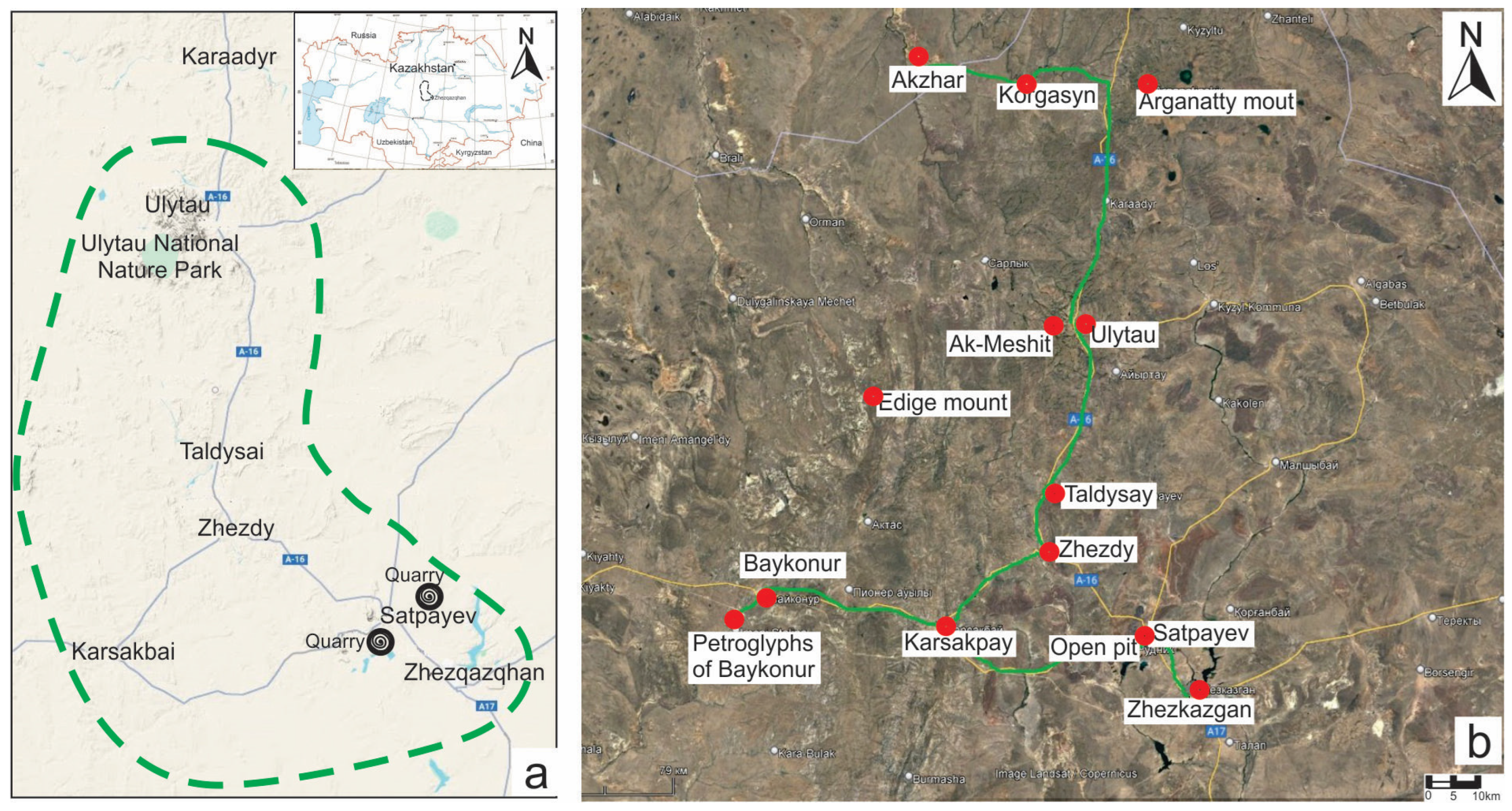
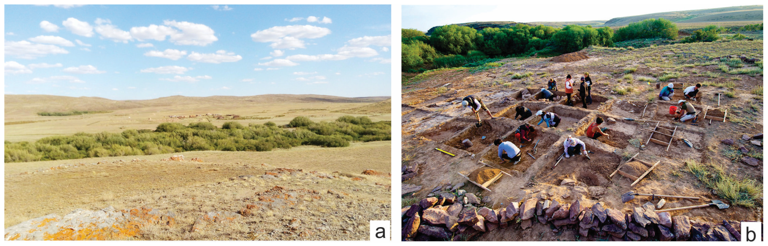
3.1. Geomorphological Structure

The following landforms are identified on the territory:
Denudation plains and plateaus: structural (stratal) plains on horizontally lying rocks (300–500 m asl) and sculptural (basement) plains on a folded base.
There is denudation of small hills with predominant relief forms in the form of dome-shaped and conical hills and ridges, not exceeding 600 m asl, and relative elevations reach 200 m. Low ridges and ridge relief are less common. Ridges in the transverse profile are often asymmetrical; the ridges are characterised by levelled or slightly convex peaks with distinct slope edges. The steepness of the slopes of the ridges falls within the range of 15–40°.
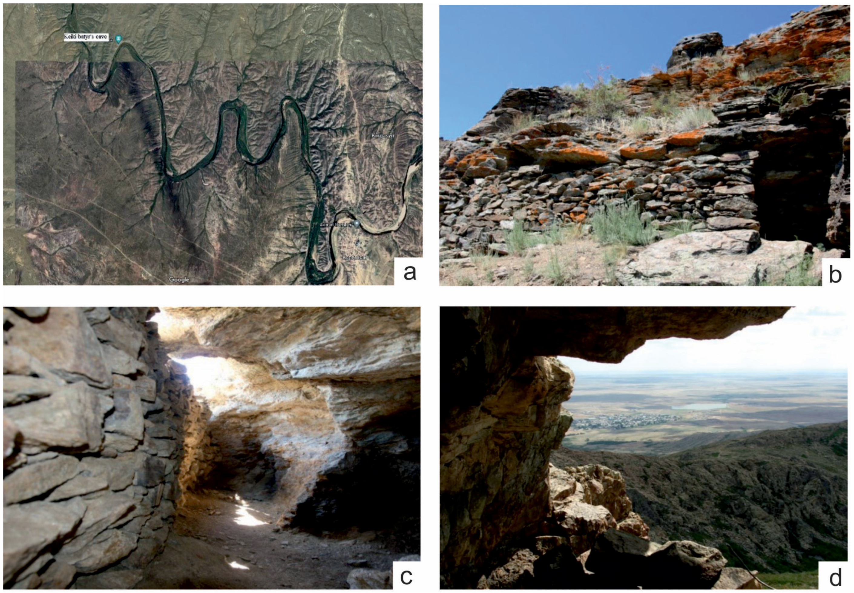
Among the monotonous small hills, areas of low mountain ridges stand out sharply, with relics of ancient levelling surfaces and a clearly defined folded base. Against the background of denudation plains located at absolute levels of 500–600 m, the individual mountains stand out like Sea Islands: Ulutau (1133 m), Idygeh (1064 m), Airtau (850 m) and Zhaksy-Arganaty (757 m).
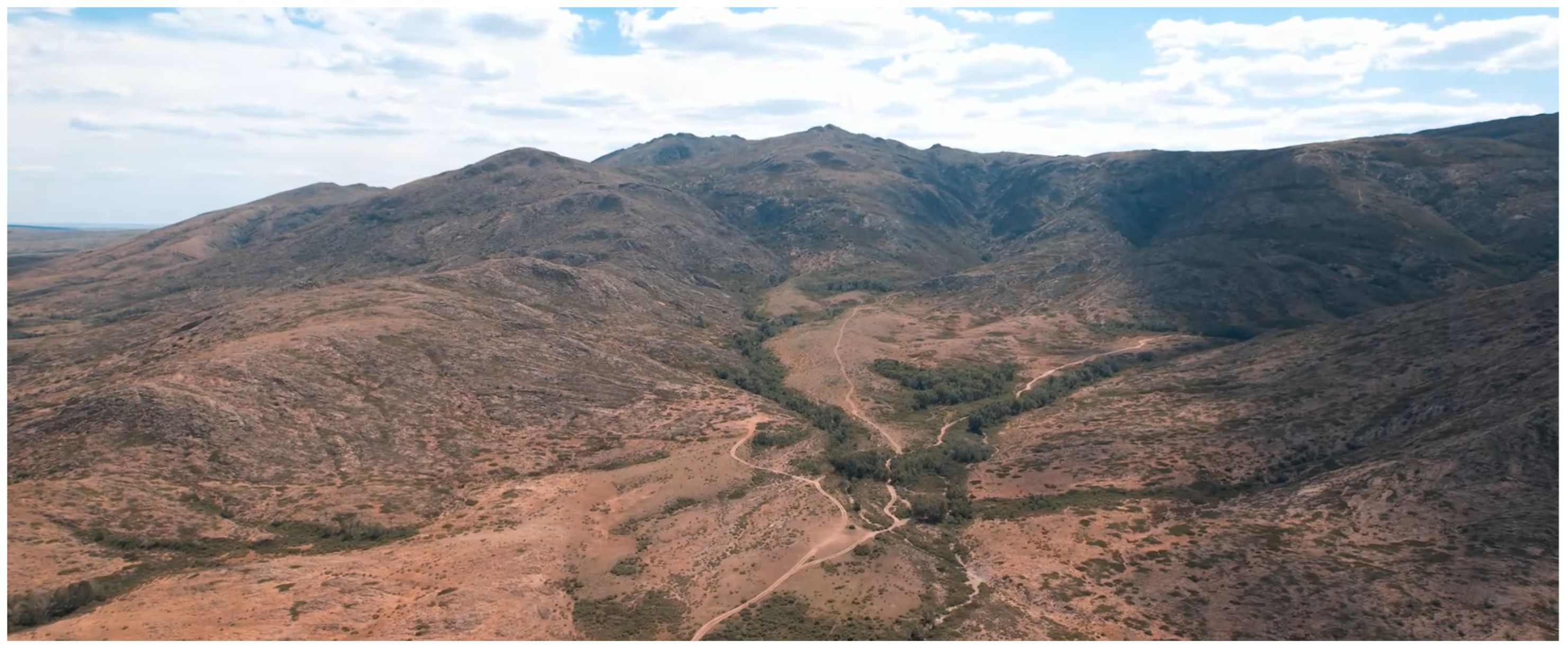
The rise of the Ulytau Mountains in the Pleistocene determines the stepped structure of their western slopes and the canyon-like type of valleys. The eastern slope of the Ulytau Upland is gentle, gradually turning into the arched rise of the Sarysu-Tengiz watershed. From the west, the hill is adjacent to the extensive structural and accumulative plains of the Turgai depression.
The Ulytau mountain range consists of low mountain ranges with an absolute height of 400–600 m above sea level, with individual sections reaching 800–1131 m (the highest peak of the massif is Mount Aulie). The second highest is Mount Edyge (1063 m high) and the third highest is Mount Koltau (925 m), located in the northern part of the mountains.
The mountain range stretches from southwest to northeast for more than 105 km; the greatest width in the central part reaches 27 km. The Ulytau massif is located in the Caledonian fold zone, surrounded by semi-deserts in the latitudinal zone.
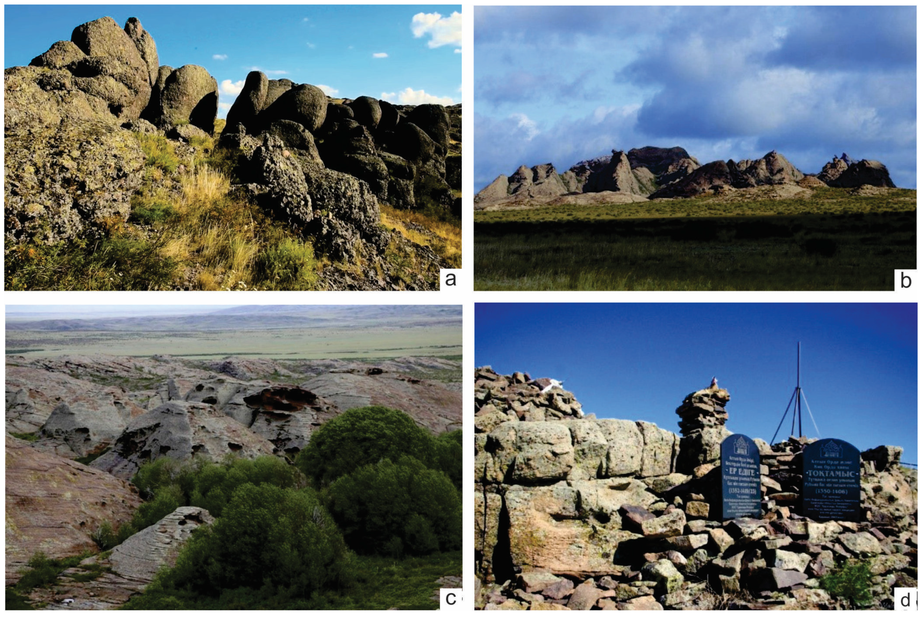
The mountains are rugged and rocky to the ground. The main part of the mountain ranges is composed of collapsing granites and is so exposed to arid denudation that “in many places it appears as a mountainous rocky desert without any developed soil cover” [28].
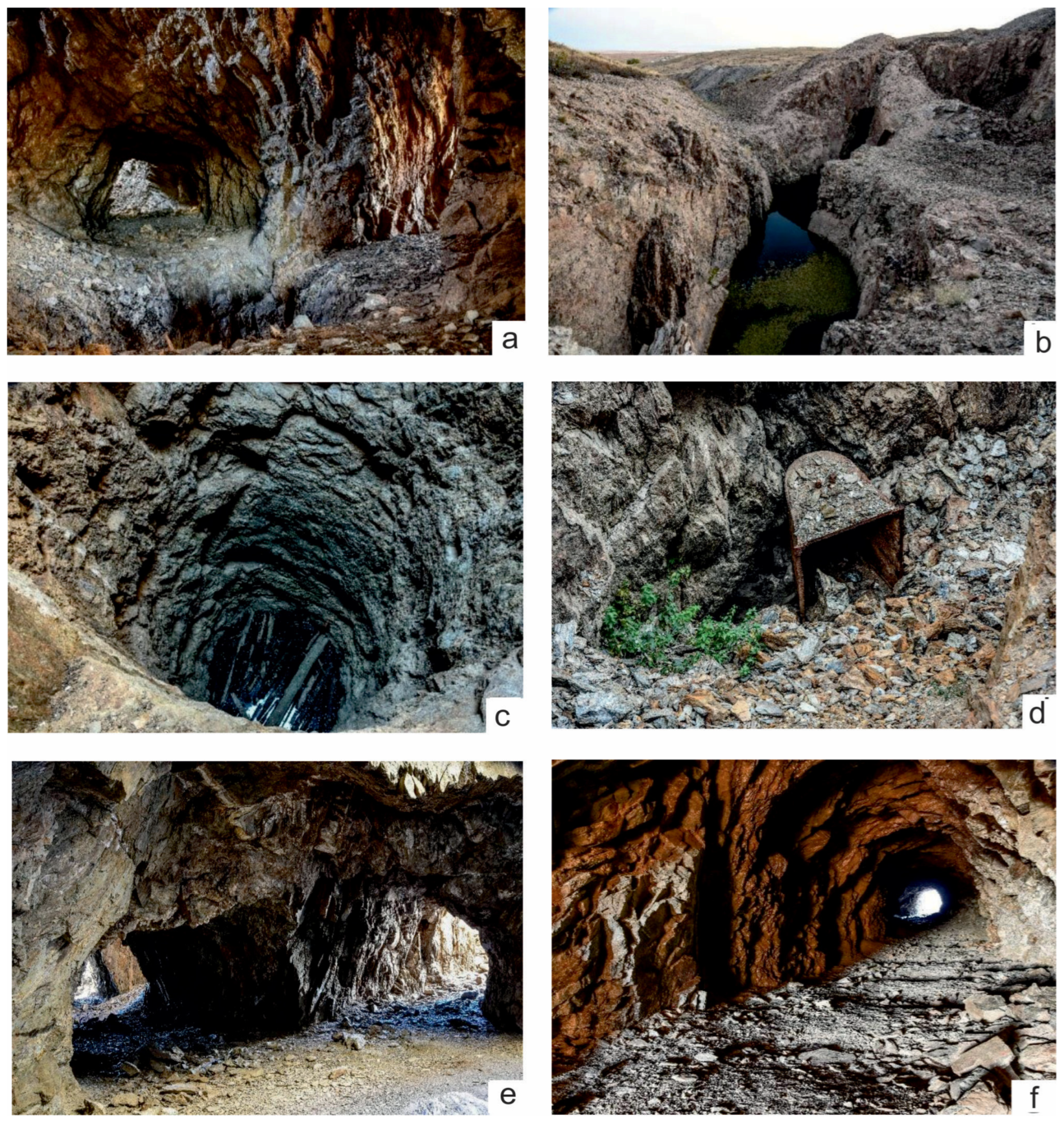
The ridge lowlands of Kyshtau and Zhaksy-Arganaty are composed of red Devonian sandstones and Precambrian shales. The absolute heights of the small hills vary from 200 to 600–700 m, and the relative elevations of ridges are 30–40 m. As with low mountains, small hills are characterised by the development of reliefs such as “kotyrtas” and “koitas” (sheep rocks).
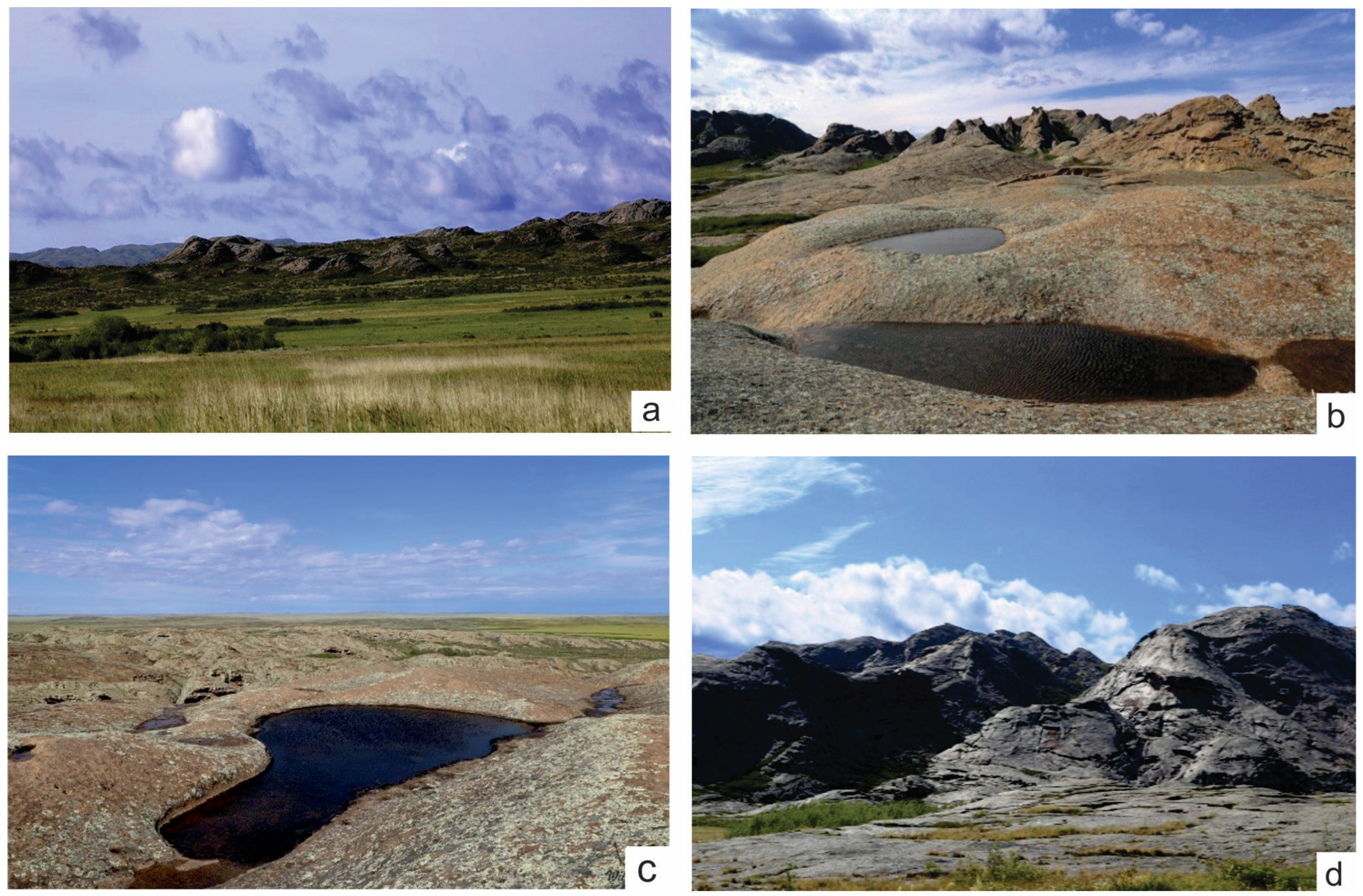
To the east of the Ulutau Mountains and Zhaksy-Arganaty, the relief of conical hills is widespread. The highest peaked hills reach a height of 100–130 m. Near the river valleys, erosion–denudation small hills are developed. On the western slopes of the Ulutau Mountains and the southern slope of the interfluve of Ishim and Sarysu, a denudation plain is developed, fixed by weathering crust with a thickness of up to 10 m. The absolute elevations of the plain surface of 360–400 m gradually decrease to the west. Within hypsometric marks of 400–500 m above sea level, on the right bank of the Sarysu River and on the western and southeastern outskirts of the Ulutau Mountains, flat and slightly undulating plains are formed on horizontally lying Paleogene-Neogene deposits.
Accumulative plains of lacustrine–deluvial origin are widespread near the Sarysu River valley.

3.2. Geological Structure

Copper deposits in the Ulytau region belong to the Zhezkazgan type, with unique and high-quality copper reserves concentrated in nine ore-bearing horizons of medium thickness in a relatively compact area.
In Kazakhstan, more than 70% of copper deposits are stratiform, the host rocks of which are sediment-hosted, with significant differences in size, reserves and mineral associations.
The Zhezkazgan ore field is located at the junction of the meridional folds of the Ulytau zone, with the latitudinally extending block-fold structures of the Sarysu-Teniz uplift. At their junction, brachyanticlines, domes and troughs are developed, which were named by Yu. A. Zaitsev [27] as a Kengir zone of brachyfold structures.
In the folded structure of the region, three floors are distinguished [7,28,29,30,31]: Caledonian the lower, Hercynian the middle and Alpine the upper.
The lower structural floor consists of complex anticlinoria (Ulytau, Kerei) and synclinoria (Yeskuly), composed of the Ordovician and Silurian strata, which forms the western wing of the Yeskuly synclinorium. Lower Paleozoic rocks are characterized by steep layer inclination angles (60–70°) and shallow intrastratal folding. The anticlinoria and synclinorium of the lower structural floor are oriented in the meridional direction.
Rocks of the Devonian, Carboniferous and Permian systems participate in the structure of the middle structural floor. Brachyfolds are of primary importance, with formations and block folds associated with large latitudinal faults.
In the middle structural level, three tectonic zones are clearly distinguished: the Ulytau uplift zone, including the Zhanai and Itauz anticlines and the Yeskuly and Ulytau domes; the Sarysu-Teniz zone of uplifts with developed latitudinal block folds; and the Kengir zone of brachyfold structures, located at the junction of the Ulytau and Sarysu-Teniz zones. The largest folds of the Kengir zone are Kengir, Uytas, Ortakagyl brachyanticlines and Zhezkazgan syncline. In the eastern part of the Kengir zone, brachyfolds of latitudinal orientation are developed; in the western part, the folds have a meridional Ulytau strike.
The listed main folded structures are complicated by folds of higher orders, forming flexures, domes and troughs. They are also susceptible to numerous rupture failures. Differently oriented Hercynian structures articulate into a single node in the Zhezkazgan region. Folded structures, oriented meridionally in the west of the region, gradually acquire a latitudinal strike to the east. At the junction of differently oriented dislocations in the area of the Zhezkazgan mine, small anticlines of a higher order are developed: the Akchiy, Pokro, Kresto and Annensky domes (Figure 2).
Upper structural floor. Cenozoic sediments rest on the Hercynian structural level almost horizontally, with a sharp angular unconformity. Vertical movements that repeatedly appeared in Alpine times are evidenced by tectonic depressions in which Cenozoic sediments accumulated.
Against the background of the Hercynian structural stage, structures of Cimmerian, Alpine and recent tectogenesis appear. Structural forms of Cimmerian tectogenesis are developed in the territories adjacent to the ore region in the form of depressions filled with Mesozoic lignite deposits. The tectonic structure of the Cimmerian structures is inherited and corresponds to the plan of the Hercynian structural floor.
Alpine tectogenesis is marked by rather powerful phases, as a result of which, large syneclises of Alpine times are formed, filled with sediments of the Mesozoic–Cenozoic age. Mesozoic sediments are folded into gentle brachyfolds, complicated by younger faults. During Alpine times, the territory of the ore region experienced uplift and intense denudation. During this period, the Kengir and Akchiy brachyanticlines, transverse to Hercynian structures, were apparently formed.
In recent and modern periods, oscillatory and tangential movements developed in the territory of the ore region, clearly recorded in the form of unconformities between the stratigraphic units of Cenozoic deposits, the elements of geomorphology in the form of tectonic ledges and the formation of terraces in the river valleys. The formation of the relief and engineering–geological conditions of the deposits in the region are also associated with these processes.

3.3. Stratigraphy of the Area

The geological structure of the area involves a complex of sediments belonging to the Precambrian, Lower, Middle and Upper Paleozoic, Mesozoic, and Cenozoic. The petrographic composition of these complexes is also complex and diverse, including crystalline schists, gneisses, Precambrian hyperbasites, intrusives, effusives, pyroclastics, normal sedimentary rocks of the Paleozoic (the degree of metamorphism of which increases from top to bottom) and sedimentary rocks of the Mesozoic–Cenozoic [28,32,33,34,35,36,37,38,39,40].
Pre-Paleozoic rocks are represented by crystalline schists. Above the sequence of crystalline schists is a suite of metamorphosed rocks of the Lower Paleozoic. Pre-Paleozoic and Lower Paleozoic rocks are exposed in the Karsakpay area in the Yeskuly and Ulytau mountains [33,40].
The modern stratigraphy of the Upper Paleozoic is more greatly detailed than the actual stratigraphic scheme and interprets the age of the Zhezkazgan formation differently [33,40].
Lower Proterozoic. The stratified Precambrian strata exposed in the core of the Yeskuly dome, according to the local stratigraphic scheme of the Zhezkazgan-Ulutau region, are attributed to the Bekturgan and Aralbay series. The total thickness of the Lower Proterozoic deposits is at least 2100 m. The Bekturgan series is composed of amphibolites and mica and mica-plagioclase schists, and the Aralbai series includes a volcanic–sedimentary sequence of albitophyric composition. The rocks of the named series are the most ancient in the region [33,40].
Paleozoic. The Cambrian system is represented by rocks of the Shaitantas Formation, which unconformably overlies Proterozoic metamorphic formations. It is overlain by the Ordovician Koskuduk Formation distributed in large sags of the roof of the Shaitantas ultrabasic massif to the northwest of Mount Shaitantas, in the extreme northeast of the Yeskuly dome. The lower half of the formation section is composed of grey and greenish-grey sandstones, mudstones, greenish-grey boulder and pebble conglomerates with pebbles of sandstones, shales, granite-gneisses, gabbro-amphibolites, and amphibolites. The upper part of the formation is a uniform sequence of greenish-grey and light grey fine-grained sandstones, tuff sandstones and siltstones, with small interbeds of mudstones. The total thickness of the formation is at least 1500 m.
Ordovician deposits are exposed in the vicinity of the Yeskuly hills in the form of a narrow meridionally elongated strip about 2 km wide and 18 km long. They are represented by sandstones, siltstones, mudstones and conglomerates; carbonate rocks occupy a significant place. The total thickness of the Ordovician exceeds 1300 m. The entire thickness is intensively crushed; often, Ordovician formations are located in tectonic blocks.
Based on lithological features, stratigraphic sequence and structural relationships, the entire complex of Ordovician formations is divided into three formations (from bottom to top): Koskuduk, Eskuly and Kyzyl Shoka. These formations are of purely local importance as they are developed over a very small area. They are all divided by disagreements [33,40].
The Lower Devonian within the territory under consideration is represented predominantly by terrigenous deposits, in contrast to the eastern parts of the Zhezkazgan region, which is composed of volcanogenic strata. Sedimentary strata of the Lower Devonian in the west of Central Kazakhstan are not known anywhere else. This circumstance, as well as the high saturation of fossil flora, gives the Lower Devonian section of the Yeskuly dome great importance [33,40].
The Lower Devonian deposits, despite their limited areal distribution, are represented by a thick (up to 2700 m) section and classified as the Kyzyltau Formation. The Kyzyltau Formation within the Kyzyltau Graben is divided into three subformations: the lower conglomerate, the middle variegated and the upper volcanogenic. The rocks of the lower part of the Kyzyltau formation consist of variegated conglomerates, gravelites, sandstones and, rarely, siltstones. The middle subformation is composed of various green-grey and red-brown sandstones. At its base, gravelstones are widely developed, and there are interlayers of small pebble conglomerates. Ash tuffs are present at the top of the section. In the extreme northeast of the Yeskuly dome, east of the Zhaman-Keregetas mountains, the middle subformation of the Kyzyltau formation is represented by alternating variegated fine- and medium-grained sandstones and siltstones, occasionally with interlayers of gravelstones. In the upper part of the section, poorly preserved prints of psilophytes were found. The upper subformation is formed by rhyolites, their paleotype varieties, rhyolite tuffs and tuff conglomerates. The total thickness of the Lower Devonian deposits is about 2500 m.
Middle-upper sections. Within the Zhezkazgan-Ulytau region, the Zhaksykon series is the most widespread among Devonian deposits. It rests unconformably on all older sediments and Ordovician and Middle Devonian granitoids. The Zhaksykon series is divided into three formations: Kyshtau, Airtau and Zhezdy. The two lower formations, when approaching the Karsakpai uplift and the Yeskuly dome, successively wedge out from north to south and fall out of the series section, and the Zhezdy formation transgressively falls on more ancient complexes. The Zhaksykon series as a whole belongs to the Middle-Upper Devonian [33,40].
The Zhezdy formation is distributed in the west of the territory under consideration on the wings of the Yeskuly dome, as well as in the extreme east of the region, on the left bank of the River Karakingir in the Uytas Mountains. The main fields of development of the formation are located in the vicinity of the Zhezdy deposit, traced along the western and northern wings of the Yeskuly dome. The Zhezdy Formation is unconformably overlain by the Uytas Formation. Greyish-green medium-grained polymictic sandstones appear locally in the sandstone conglomerate sequence.
The Zhezdy formation in the area of the Zhezdy deposit is broken through by cutting veins of barite–iron–manganese composition. The thickness of the Zhezdy formation in the vicinity of the Zhezdy field varies greatly: reaching a maximum in the zone of the Zhezdy and Promezhutochnoye fields, it quickly decreases, according to drilling data, to the south and north. The thickness of the Zhezdy Formation varies from a few tens of m to 550 m.
The rocks of the Upper Devonian are represented in the region by the Famennian stage, composed of terrigenous and carbonate rocks. Its outcrops occupy small areas mainly to the northwest and northeast of Zhezkazgan, where they are usually confined to the wings of anticlinal folds. Famennian deposits are well exposed in the coastal cliffs of the River Karakingir and at the southern end of the Itauz ridge. The Famennian stage is composed of a variety of limestones, dolomites, sandstones, siltstones, gravelites and small pebble conglomerates. The total thickness in most of the Zhezkazgan region is 220–520 m. Carbonate rocks, mainly dolomites, are present here only in the uppermost parts of the section [33,40].
Compared to the most complete section of the Famennian stage, located in the middle reaches of the River Karakingir to the north of the territory under consideration, sections of the south of the Zhezkazgan region are abbreviated. In both the western and eastern sections, at the base of the Famennian, there are terrigenous formations classified as the Uytas Formation; its upper part, represented by limestones and dolomites, belongs to the sulciferic horizon. The Uytas Formation corresponds to the Meisterian and partly Sulciferian horizons.
The Uytas Formation is a red-coloured, locally variegated terrigenous sequence composed predominantly of arkose and feldspathic-quartz sandstones, siltstones and, less commonly, mudstones. Up the section, it is gradually replaced by limestones of the upper Famennian stage. At the same time, variegated terrigenous formations are partly replaced by limestones. In the western parts of the Zhezkazgan region, the Uytas Formation lies unconformably; its base is composed of a characteristic thin (6–50 m) member of red-coloured, well-sorted quartz sandstones. This marked horizon is clearly visible on the northern, western and eastern wings of the Yeskuly dome. In the area of the Zhezdy and Promezhutochnoye deposits, strata deposits of manganese ores are confined to the base of the Uytas Formation. In the northern parts of the Yeskuly dome, under a member of quartz sandstones, there is a thin horizon of boulder conglomerates with pebbles and boulders of quartz, quartzites and acidic volcanic rocks. In the eastern parts of the Zhezkazgan region, the Uytas Formation has greater thickness and is connected with the underlying Zhezdy Formation by a gradual lithological transition. There is no disagreement on its basis here [33,40].
As illustrated in Figure 3, the sulciferous horizon in the east of the Zhezkazgan region is composed of dark grey limestones and dolomites. The limestones are fine-grained, less often pelitoform, with fine organic detritus, and dense. At the bottom, limestones usually contain an admixture of sandy and clayey material. The transition from the Uytas Formation is gradual.
Limestones in the lower carbonate part of the section have a characteristic lumpy composition, are thick-layered, have bumpy bedding surfaces and usually contain numerous remains of brachiopods. Higher up the section, the limestones become more dense and thick-plated, and interlayers of dolomitized limestones appear there, which are replaced at the very top of the section by a pack of dark grey and black dolomites containing subordinate interlayers of limestones. The thickness of carbonate deposits increases from south to north from 100 to 250–300 m. The dolomites are conformably overlain by light grey limestones of the Tournaisian stage.
Carbon deposits are widespread in the study area [33,40].
The Lower Carboniferous is represented by a carbonate strata, which, in the upper part of the section, gives way to terrigenous formations that everywhere underlie the ore-bearing strata.
The Tournaisian stage (Kassin and Rusakov horizons) and the lower Ishim layers of the Visean stage are formed mainly by limestones with an admixture of detrital and clayey material that is layered and silicified; the Famennian and Tournaisian stages and lower Ishim layers are combined into a limestone formation, widespread throughout the western part of Central Kazakhstan.
The Upper Ishim layers and Yagovkin, Dalnen and Beleuty horizons belong to the Visean and Serpukhovian stages, represented by terrigenous rocks and limestones. They are characterised by a clearly expressed rhythm of bedding. In the upper part of the limestone–terrigenous formation (upper Beleuty layers), there is no clear rhythm in the structure of the section.
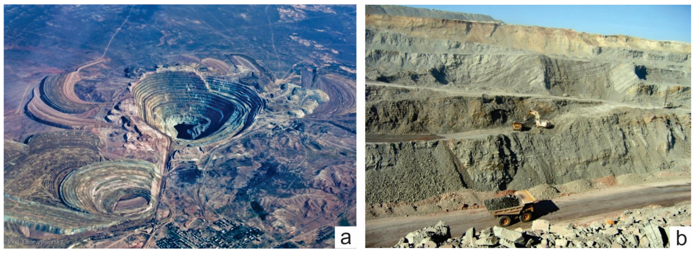
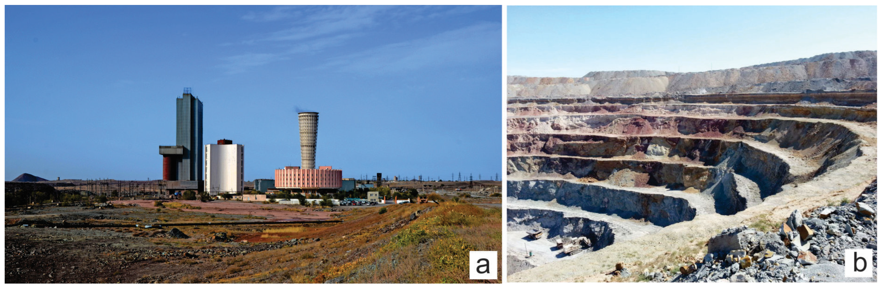
In the Zhezkazgan deposit area, copper-bearing rocks, represented by Upper Carboniferous deposits, are widely developed. The Zhezkazgan series is divided into two formations: Taskuduk (lower copper-bearing) and Zhezkazgan (upper copper-bearing).
The section of the ore-bearing strata within the Zhezkazgan deposit was studied by academician K.I. Satpaev (1935) [41] and refined according to subsequent studies by other authors [29,31,32,42].
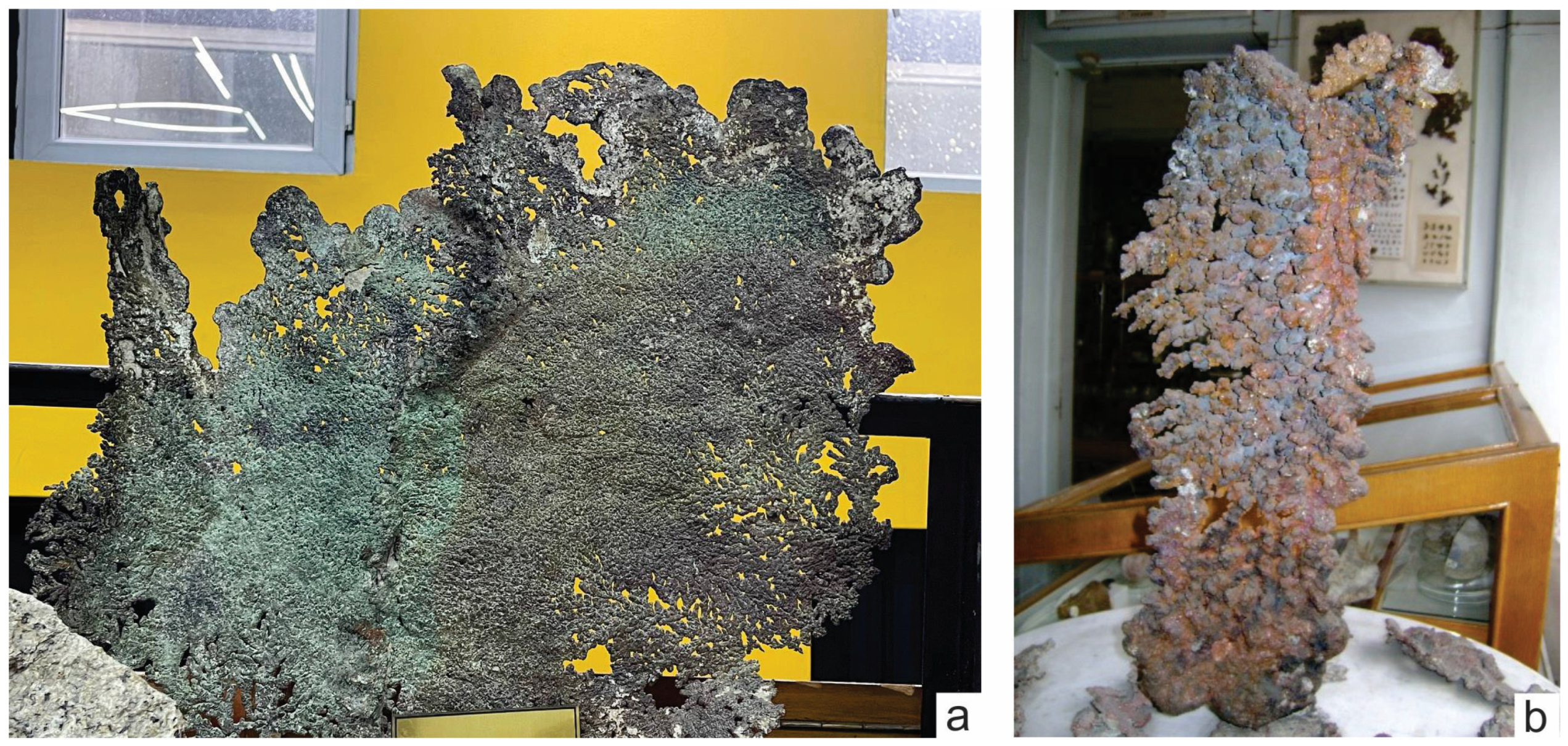
The ore-bearing formations are represented by a strata of alternating terrigenous and clayey rocks that are uniform in structure; sandstones and siltstones usually predominate, with mudstones subordinate to them. Interlayers and lenses of conglomerates and limestones are rare. Of particular importance is the marked horizon of silicified limestones, which can be traced with very small interruptions throughout almost the entire territory of the development of productive formations. The predominant colours of rocks are brown, red-brown, grey and green-grey. In many places, grey and green-grey sandstones are associated with copper and lead mineralisation, which is usually absent in rocks with brown and red-brown colours [33,40].
The rocks involved in the structure of the lower Taskuduk ore-bearing formation gradually transform down the section into lithologically similar Upper Beleutinian layers. The Taskuduk Formation consists of 16 layers of red-coloured and grey-coloured rocks, forming three ore-bearing horizons. The lower boundary of the formation is drawn by the appearance of red-coloured mudstones, siltstones and, less commonly, grey-coloured sandstones with a brownish tint. Basically, the boundary coincides with the roof of a thick layer of greenish-grey sandstones crowning the section of the Upper Beleutinian layers.
The Zhezkazgan Formation consists of separate grey-coloured layers of sandstones, siltstones and mudstones, alternating in the section, combined into seven ore-bearing horizons. At the base of the formation lie the ubiquitous Raimundovian conglomerates, consisting of well-rounded pebbles of rocks from the surrounding area. The rocks of the ore-hosting Zhezkazgan Formation in all areas of their distribution are characterised by small hilly reliefs and the development of narrow ridges and crests. The total thickness of the formation is 600–700 m.
Above the ore-bearing strata lie the rocks of the Permian system and Mesozoic–Cenozoic.
The Permian system within the Zhezkazgan region is divided on a lithological basis into two formations: Zhidelisai the lower and Kengir the upper [33,40].
The Zhidelisai Formation is composed of fine-grained red-brown and grey-violet terrigenous rocks. In the deposits of the Zhidelisai Formation, relatively frequent facies variability is observed, expressed in the replacement of mudstones that dominate the section with siltstones and sandstones. Closer to the top of the section, the number of sandstones increases, and their cement becomes significantly calcareous. The thickness of the formation is 300–410 m.
The Kengir Formation (P kn) in its lower section consists of brownish-pink to whitish, fine- to very-fine-grained calcareous sandstones and siltstones, interlayered with brownish-grey mudstones and grey, thin-platy marls. In the clayey marls, high-strength gypsum is observed. The thickness of the Kengir Formation ranges from 1100 to 1450 m.
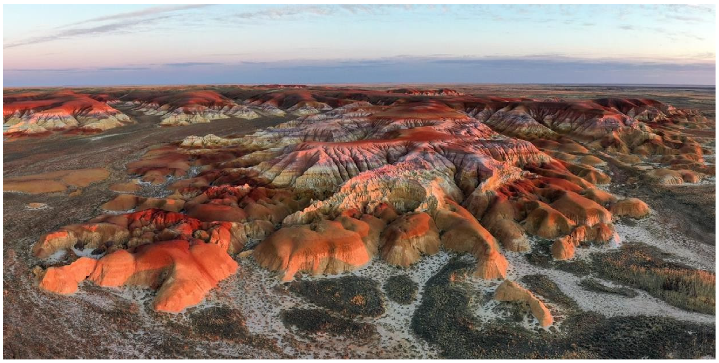
Mesozoic. On the territory of the Zhezkazgan ore district, Mesozoic weathering crusts of a relatively narrow distribution are developed along Paleozoic sedimentary strata and intrusive rocks. Outcrops of weathering crust are confined to watershed spaces and covered by Paleogene or Neogene deposits. The weathering crust has a kaolin, nontronite and silicified profile [40].
Cenozoic. Paleogene deposits are represented by Akchi and Chagray Formations that are overlain by the Aral and Zhilandy Formations of the Neogene age.
The Akchi Formation is also unconformably overlain by younger Neogene deposits, which lie sharply unconformably on the Paleozoic surface. The formation is represented by a variety of variegated clays, in which a large amount of sand and gravel–pebble material is often mixed. The maximum thickness of the formation is 110 m.
Rocks of the Chagrai Formation, represented by a homogeneous layer of quartz sands and pebbles with rare lens-shaped interlayers of grey clays and siltstones, everywhere overlie variegated clays of the Akchi Formation. Its thickness varies from 12 to 23 m.
The Neogene includes deposits of the Aral, Zhilandy and Pavlodar formations. Lumpy green gypsum clays of the Aral Formation usually fill ancient depressions produced in the Mesozoic peneplain by pre-Miocene erosion and are widespread.
Clays often contain small (4–5 mm), concentrically structured beads of iron and manganese hydroxides. In some places, the clays acquire yellowish and brownish tints, and fine gravelly material of Paleozoic rocks appears there. Crushed stones of milky-white quartz and silicified limestones of the Tournaisian stage are more common. Transparent lamellar gypsum forms small brushes and druses. In general, the Aral Formation is characterised by uniformity and consistency of composition. The main rock-forming minerals of clays are montmorillonite and beidellite.
The Zhilandy Formation is widespread in the northern and central parts of the territory, usually within watershed areas. The formation is represented by yellowish-grey and brown clays, loams and sandy loams containing fragments, crushed stone, and poorly rounded pebbles of Paleozoic rocks. At the base of the formation, there are usually greenish-brown lumpy clays with fragments of Paleozoic rocks up to 1 m in size. The thickness of the horizon varies but does not exceed 5 m. Above is a horizon of brown sandy clays with lens-shaped sand layers up to >15–20 m thick. The section is crowned by, as a rule, brown and red-brown non-layered clays with crushed stone and pebbles of Paleozoic rocks with a thickness of 7–10 m. The total thickness of the Zhilandy formation in the most complete sections does not exceed 35–40 m.
The Pavlodar formation is the youngest in the context of the Neogene system [33,40]. Its outcrops are widespread in the west and central parts of the territory. Relatively small areas are occupied by it in the northeast of the region, along the left bank of the River Karakingir. It is represented by various alluvial deposits of ancient river valleys: sands, sandy loams and pebbles. On the surface of the accumulative plains, composed of sediments of the Pavlodar Formation, residual forms of meanders are preserved. Often, at the base of the Pavlodar Formation, there are boulder pebble accumulations, which consist mainly of well-rounded boulders and pebbles of milky white quartz and less often of pebbles of effusive rocks. The thickness of the Pavlodar formation within the territory under consideration is 18–20 m.

3.4. Intrusive Complexes of the Area

In the territory of the Zhezkazgan ore district, outcrops of intrusive and metamorphosed formations are known only within the core of the Yeskuly dome. On the surface here, Precambrian and Lower Paleozoic rocks are identified, containing intrusive complexes of varied composition and age [25,32,33,40].
Of particular interest are Proterozoic endoliths. These are metamorphosed rocks, mainly gabbro-amphibolites with inclusions of magnetite, titanomagnetite, epidote and gneiss granites. The latter are represented by massive varieties with large-block individuality.
The age of gabbro-amphibolites is conventionally accepted as Proterozoic since they break through the Savinsky Formation of the Lower Proterozoic and, in turn, are subject to granitisation. In the gneiss complex of the Yeskuly dome, the most ancient are plagiogranitic gneisses; they are cut through by gneiss granites.
Ordovician intrusive rocks are also confined to the core of the Yeskuly dome and the Shaitantas massif of ultrabasic rocks, which cut through Precambrian granite-gneisses and volcanic–sedimentary and sedimentary rocks of the Lower Paleozoic. Within the Shaitantas massif, gabbros form isometric or somewhat elongated bodies at the eastern edge of the massif. During the processes of hydrothermal metasomatism, due to basic and ultrabasic rocks, listvenites, garnet–pyroxene rocks and skarns are formed in contact with limestones.
Pre-Devonian granitoid intrusions make up two massifs on the western slope of the Yeskuly dome: the Zhezdy and Naizatas massifs, which are separated from each other by the Zhezdy field of Precambrian shales and amphibolites. Both intrusive massifs are similar in composition and represented by biotite granites, quartz diorites and quartz syenite-diorites, complicated by a vein series of granites and quartz diorites.

4. Methods and Organisation of This Study

This work was organised according to the results of a study and analysis of the statutory and advisory materials of the International Program for Geoheritage and Geoparks of UNESCO [17] and an analysis of literary and stock materials on geology and stratigraphy of the territory. The experience of the UNESCO Global Geoparks was studied (materials from the relevant sites).
The establishment of a protected area is usually a long and complicated bureaucratic process. In order to assess the scientific, academic and tourism value of geosites, a thorough inventory is required [43].
In order to create an inventory and initially assess the geoheritage of the Ulytau region, field surveys were conducted in the summers of 2023 and 2024 under grant AP14871967 «Geological-palaeontological and palaeoclimatic studies of Cenozoic sediments of Central Kazakhstan as a basis for predicting mineral deposits». The surveys included route mapping, photographic documentation and detailed site descriptions. Additionally, in the preparation of this article, observations from authors with extensive experience in geoheritage research [44,45] who conducted geotours and scientific expeditions across Kazakhstan were utilised.
All identified geoheritage sites were categorised. Depending on which geological phenomenon was recognised as unique, several types of geoheritage objects were distinguished [10,46], namely, geomorphological, tectonic, stratigraphic, palaeontological, sedimentary, paleogeographic, magmatic, metamorphic, geochemical, mineralogical, hydrogeological, geothermal, geocryological, geotechnical, pedological, economic–geological, historical–mining–geological, and cosmogenic types. At the same time, particular geoheritage objects often turned out to be mixed as they combined two or more types.
As a result of the application of these methods, a systemic assessment of the territory’s potential was formed, presenting natural heritage objects in interrelation with cultural, educational and economic potential, and forming vectors for the sustainable development of the territory.
All geoheritage objects were ranked into four categories depending on the degree of uniqueness (in increasing order): local, regional, national and international.
The authors compiled a table that allows for the evaluation of geoheritage sites. Within each rank, objects were assessed on a 5-point system according to the following criteria: accessibility, preservation, scientific–educational significance, aesthetic appeal [9] and tourist value (Table 1).
Appropriate for the creation of geoparks are districts that were and are under mining operation as there are sufficient populations and a lack of jobs; as a rule, in these areas, there are unique geological objects nearby that need protection, systematic scientific work is being carried out and there are there are active residents and local communities (geo-communities) [21,22]. In the Ulytau region, mineral extraction is actively underway, with deposits accessed through open pits and mines that hold potential appeal for tourists. The area is home to regional and school museums with a strong focus on geological displays, contributing to the promotion of its geological heritage. Industrial, scientific, aesthetic and educational tourism are all flourishing in Ulytau, making it a significant geotourism destination where mining activities and natural heritage are closely intertwined.

5. The Potential Geosites

5.1. Zhezkazgan Group of Deposits

Near the city, in the northern direction, there are large quarries of cuprous sandstones of the Zhezkazgan group of deposits: Zhamanaybat, Itauyz, Saryoba, etc. This unique deposit has no equal among similar ones in the number of ore-bearing horizons or in the multicomponent material composition of the ores.
Large deposits near the cities of Zhezkazgan and Satpaev are developed by open-pit mining, and visiting the quarries becomes a real journey into the bowels of the Earth. In the quarry of the Zhezkazgan deposit, stratiform, ribbon- and lens-shaped ore bodies occur in accordance with the host rocks. Mineralisation is most often multi-layered; there are 26 ore members in nine ore-bearing horizons. The main reserves of copper ores are concentrated in deposits of primary sulfide ores at a depth of 300–350 m. The length of individual ore bodies reaches several kilometres, with a thickness of 1 to 20 m or more. The largest ore bodies sometimes reach enormous sizes (area of several square kilometres, thickness of several tens of metres).
The age of the host rocks varies from Proterozoic to Neogene. Large industrial deposits of cuprous sandstones are known mainly in Precambrian, Carboniferous and Permian deposits.
The section of sediments composing the trough begins with Lower Devonian volcanic rocks of various compositions, interbedded with red sandstones. Above this lie terrigenous and carbonate deposits: red sandstones and conglomerates of the Middle Devonian, silicified limestones, and sandstones and marls of the Lower Carboniferous. The total thickness of these deposits is 1500 m. They are conformably overlain by the productive Zhezkazgan formation of the Middle-Upper Carboniferous age with a thickness of about 700 m (Figure 4). Its section is represented by rhythmically alternating grey and red sandstones and siltstones with subordinate layers of conglomerates. The Zhezkazgan Formation is overlain by crimson-red sandstones, mudstones, limestones and marls of the Lower Permian age. Paleozoic deposits are in places covered by a cover of variegated, weakly cemented sandstones, clays, sands and pebbles of the Paleogene and Neogene.
The bulk of copper is concentrated in three widespread minerals: chalcopyrite, bornite and chalcocite. Lead mineralisation is represented by galena and zinc mineralisation by sphalerite (mainly cleiophane). Silver is present in ores in the form of independent minerals (including native silver) or included as an isomorphic impurity in sulfide lattices. Rhenium is associated with copper sulfides; its maximum content is established in bornite. A new rhenium mineral, Zhezkazganite, was discovered at the deposit. Among the trace minerals in the ores, pyrite, marcasite, arsenopyrite, betechtinite, copper and cobalt arsenides and fahlores were also identified (Figure 5).
The main primary minerals are chalcocite, bornite, chalcopyrite, galena and sphalerite; the minor ones are pyrite, marcasite, covellite, faded ores, native silver, rar, betechtinite, domeikite, stromeyerite, argentite, Zhezkazganite, pyrrhotite, safflorite and cobaltite. Of the secondary ore minerals, 31 are described: native elements, oxides, sulfides, halogens, carbonates, sulfates and silicates. The non-metallic minerals are calcite, quartz, barite, chalcedony, anglesite, gypsum, aragonite, etc. (Figure 6).
The main accompanying components of industrial importance are silver, rhenium, osmium and cadmium; the minor ones are cobalt, nickel, molybdenum, tin, bismuth, arsenic, antimony, tellurium, selenium, gallium, indium, thallium, germanium, palladium, platinum and mercury.
The main ore minerals are chalcocite, bornite, galena and sphalerite. The ores, in addition to copper, also contain lead, zinc, molybdenum and silver. A new mineral Zhezkazganite was discovered at the deposit.
Ore has been mined here since the beginning of the XX century. In 1943, the Zhezkazgan Copper Smelting Plant was formed, which included 17 mines of the Zhezkazgan mine, and the mine production was united into the Zhezkazgan Mining Administration.
The city of Satpaev is 7 km northwest of the city of Zhezkazgan. It was built in the 1950s of the last century specifically for miners and, at first, it was a working village called Nikolsky. In the 1970s, the village received the status of a city and, in 1990, it was renamed in honour of the famous Kazakh geologist Kanysh Satpaev, organizer of Kazakh science and founder of the school of metallogeny in Kazakhstan.
The Annenskaya mine (Figure 7), built in 1985, is clearly visible from Satpaev. It is one of the most modern shafts in the mine and an example of industrial architecture (Table 2).
All these objects—quarries, mines and anthropogenically modified landscape of the territory—can be used for the development of industrial, scientific and educational tourism.

5.2. Karsakpai

Approximately 90 km west of the city of Zhezkazgan and 70 km from the city of Satpaev is the village museum of Karsakpai. Here is located the first metallurgical plant, built in the steppes of Central Kazakhstan at the beginning of the twentieth century, and the Kanysh Satpaev’s house museum, dedicated to the prominent geologist, founder of the metallogenic school and researcher of the Zhezkazgan copper and magnesium deposit. The village was founded in 1912 by a foreign concession under the construction of the Karsakpai Copper Smelter (eng. Korsak-Pay Smelter).
In 1908, the English engineer Harvey visited the Zhezkazgan deposits and, upon returning to London, reported that one of the largest copper deposits in the world was identified here, although at a great distance from the railway.
In December 1912, it was decided that a copper smelter should be built in the Karsakpai tract. Here, the river made a loop and, according to the project, it was blocked with a small dam in a reservoir, which survives to this day. Eighteen small mines with a depth of 6 to 80 m were laid, and exploration work was carried out for the construction of a narrow-gauge railway with a length of 120 km. In 1913, a small brick factory was built, several pits were dug for industrial buildings and 15 mud-brick houses were built. In 1914, the foundation was laid for an enrichment plant for the future copper plant. Everything needed was carried on horses and camels. In 1914–1917, a narrow-gauge railway was built connecting the village of Baikonur with Karsakpai and Dzhusaly stations. Now, in the village of Karsakpai, only isolated fragments of the narrow-gauge road remain, dismantled in the early 1980s. On 8 October 1917, a train arrived in Karsakpai with equipment, which began to be quickly installed, but, due to the civil war, the work was not completed.
The exploration and industrial development of the deposit continued in the mid-1920s of the last century under the leadership of geologist Kanysh Satpaev. In 1928, the Karsakpai copper smelter began operating, with the reverberatory furnace and concentration plant being the first in the USSR. The Karsakpai Metallurgical Plant remains a city-forming enterprise to this day. Here, you can still see working pre-revolutionary English equipment.
Currently, in connection with the opening of the Zhezkazgan copper smelter, the Karsakpai Metallurgical Plant specialises in ferrous metallurgy, producing more than 80 types of components for mining and metallurgical equipment.
In Karsakpai there is a house museum of a prominent Kazakh geologist, scientist and organiser of science, academician K.I. Satpaev. The museum’s exhibitions include household items of that time, personal belongings of the famous Kazakh geologist, books, rock samples and other unique museum objects (Figure 8). Samples of copper ore are exhibited near the house (Table 3).
The village of Baikonir is located 55 km west of the village of Karsakpai. Here, in a depression filled with Mesozoic lignite deposits, brown coal used for metallurgical purposes has been mined since ancient times. This is not far from the village on flat blocks of rocks on both sides of the Baikonir River.
The Baikonyr rock paintings (Figure 9) were found 2.6 km west of the village of Baikonyr. Along the river, on the rocks, groups of rock paintings of animals, beasts and images of hunting scenes and chariots are carved. The images date back to the Bronze Age, Early Iron Age and Middle Ages. In some places, you can see running wolves, people on horses and camel caravans.

5.3. Town of Zhezdy

A total of 35 km northeast of the village Karsakpai, along the highway of Zhezkazgan-Ulytau, is the village of Zhezdy, famous for its manganese deposits.
The Zhezdy group of deposits is located in two groups of ore bodies, spaced 70 km from each other. The deposit has mines, a processing plant and an industrial centre.
In the Zhezdy deposit, manganese is found in the form of the mineral braunite with an admixture of psilomelane.
Manganese minerals in the area of the Zhezdy River were discovered during the expedition of K.I. Satpaev in 1928. Further exploration and industrial development of the deposit were continued under the leadership of K.I. Satpaev in 1941–1942. During the war years, the Zhezdy deposit produced 70.9% of all manganese ores in the country.
The ore basin is located on the southwestern wing of the Eskul anticline, near the village of Zhezdy. It is composed of Upper Devonian large-pebble conglomerates, arkosic sandstones and siliceous limestones. The basin is divided by the Zhezdy, Karsakbai and Agadyr faults into southwestern, central and northeastern blocks. Ore bodies in the form of layers, lenses and veins occur in the conglomerates of the Uyta deposits. The basin extends in a northwest direction for 5 km and the thickness varies from N to SE from 120 to 40 m. There are 6–7 ore-bearing layers in the geological section. The mineral composition of the ores consists of brownite, hematite, magnetite, jacobsite, psilomelane, pyrolusite and limonite.
The village is famous for its one-of-a-kind Museum of the History of Mining and Smelting, which reflects all stages of the long history of mining and studying copper shales in Central Kazakhstan. In addition, in the region, near the village of Baikonur (not to be confused with the cosmodrome), there are also coal seams, which have also been mined since ancient times. The coal was later used for the furnaces of the copper smelter in the village of Zhezdy.
The museum’s exposition is located in the open air on an area of 3 hectares, as well as in exhibition halls with an area of 916.31 sq.m.
The museum’s fund consists of more than 15 thousand exhibits covering the history of mining and smelting, material culture, and the ethnography and life of the Kazakh people. The museum shows the history of copper mining from the Paleolithic to the present: dioramas, ore samples, a working model of an ancient copper smelting furnace from the settlements of Atasu and Milykuduk (II-I BC), samples of drilling and tunnelling equipment, trains transporting ore, and thousands of other valuable and rare exhibits (Figure 10).
The pride of the museum is the reconstruction of two Bronze-Age furnaces: a cheese-blowing furnace and a crucible furnace, which is a prehistoric “full cycle plant” with all links of the metallurgical chain (Figure 11 and Figure 12).
The museum is an educational and outreach centre that regularly works with schoolchildren and students. The house museum of K.I. Satpaev in the village of Karsakpai and the Museum of the History of Mining and Smelting in the village of Zhezdy form a single historical and cultural complex (Table 4).

5.4. Taldysai

North of the village of Zhezdy, 16 km from it, in the tract at the confluence of the Ulken Rivers Zhezdy and Bala Zhezdy, near the village of Taldysai, there is a metallurgical historical and cultural complex created as part of the Ulytau nature reserve. The ore fields of the Zhezkazgan-Ulytau mining and metallurgical centre have been developed since ancient times, but, to date, numerous settlements and production sites of Bronze-Age miners and metallurgists have been destroyed by geological and industrial quarries. Only a few monuments were outside the zone of industrial development of the region, one of which is the settlement of Taldysai [47,48,49,50,51,52].
This was facilitated by the simple stratal shape of many deposits, large sizes and flat and shallow occurrences of cuprous sandstones and shales, which allowed for the use of an open method for developing their deposits.
Since 1994, comprehensive study of the monument has been carried out, including field and laboratory research using natural science methods and experimental modelling. There are many monuments concentrated within a radius of 3–5 km of historical and cultural heritage of different eras from the Paleolithic to the late Middle Ages and ethnographic modernity: Stone Age sites, a settlement of metallurgists and a burial ground of the Bronze Age, a mound “with a mustache” of early nomads, the medieval settlement of Baskamyr, a guardhouse tower, and a cave, which was inhabited both in antiquity and in the Middle Ages.
The most known scientific artefacts of Taldysai date back to the Bronze Age: one of the settlements of ancient metallurgists was discovered here, where almost the full cycle of metallurgical production was carried out. This was the smelting of copper from ore, its refining, the casting of products and their forging finishing from metallurgically “pure” copper.
Of interest are the discovered ancient mine-type metallurgical furnaces, representing the pits dug down to 2.5 m, used for the enrichment and smelting of sulfide ore. Also, ancient metallurgists used small above-ground furnaces for smelting oxidised ores. The smelting furnaces are located next to or inside the dwellings of the ancients, which is evidence of the existence of entire settlements of metallurgists.
A feature of the Late Bronze Age was the formation of craft production in metallurgy. Settlements with a clearly defined metallurgical specialisation appeared, sharply increasing the volume of copper smelting production, and other separate specialised structures appeared in settlements (Atasu, Akmustafa, Myrzhik, Taldysai, etc.). At the same time, the technology of metallurgical production itself became more sophisticated. It was the commercial production of copper, supplied to the trans-Eurasian trade routes of that era, that was the basic area of functioning of the mining and metallurgical centres of Kazakhstan.
Metallurgical centres similar to those of Taldysai have been found at the sites of northern Betpakdala. In the settlements of Atasu, Akmustafa, Akmaya and Myrzhik, also located in the Ulytau region, archaeologists have identified shaft-type ovens, like those at Taldysai. Thermal engineering structures of the Bronze Age of this type have no analogues outside of Kazakhstan.
Copper items found in the territories of modern Russia, Central Asia and the Balkans are very similar to those found by archaeologists in Taldysai (Figure 13). This became the reason for the hypothesis about the existence of the Copper Road, which originated long before the famous Great Silk Road. Through it, goods made of copper, bronze, silver and gold from the Ulytau-Zhezkazgan region went to Altai, Tarbagatai and all the way to West Asia and Greece.
Alkei Margulan assumed that with the emergence of the transit Great Silk Road, the Copper Road became one of its branches, supplying metal products to the East and West. Mentions of the Steppe Road are preserved in Herodotus’s “History” [24] (Table 5).

5.5. Ulytau Mountains

In Kazakh language, “Ulytau” means “Great Mountains”. For many kilometres of endless steppe, a mountain range is visible, which amazes with its majesty and beauty. The natural diversity of the Ulytau region is grand. In the north are the granite Ulytau Mountains (Figure 14), composed of Precambrian and Paleozoic sediments, with numerous springs and lakes, surrounded by groves of birch and pine trees. At the foot of the mountains are mixed herb meadows, gramineous meadows and meadow salt marshes. Only in the crevices of rocks do steppe grasses, wormwood and small shrubs live, and on large screes, thickets of creeping juniper and deciduous shrubs settle. On the slopes and on rocky peaks grow representatives of light forests, such as birch, aspen and juniper, on light chestnut soils, and along the river banks there are shrubs—raspberries, currants, willow, feather grass, sheep fescue and wormwood.
To the south, there are dry feather grass steppes, with small rivers and lakes, turning into a desert area and salt marshes.
Ulytau Mountains represent one of the oldest mountain ranges in Saryarka. They are composed mainly of granites and granodiorites. The massif consists of small lows and ridges stretching from north to south for 200 km. Its highest point is Akmeshit Peak (1131 m) (Table 6).

5.6. Mount Akmechet-Aulie

Akmechet-Aulie is a mountain in the Ulytau national park, 2 km from the village of Ulytau, and is the highest point of the Ulytau mountain range at 1131 m high. The mountain is composed of granodiorites of the Karamenda complex of the Middle Devonian overlying deposits of alaskite granites of the Orlinogorsk complex. The latter are exposed in a wide massif surrounding the elevated peak of Mount Akmechet.
The mountain is an object of pilgrimage and probably had sacred significance already in the Bronze Age, confirmed by numerous archaeological sites: mounds, sanctuaries and fortifications. According to one legend, the burial places of seven holy Sufi healers are located on the mountain. Here are the remains of a square 42 × 42 m building built from fragments of stone on clay mortar; its foundation is made of 30 × 40 cm granite slabs.
At the very foot of Mount Akmechet-Aulie (Figure 15), a dome of a cave is seen. Its depth is about 2 m. The facade arch of the left wing suffered destruction.

5.7. Mount Edige

Edyge Peak, 1063 m high, is located 35 km west of the village of Ulytau. It was named, as with the entire mountain, after Edyge bi, committed to the earth of the sacred Ulytau at its top. The burial place of Tokhtamysh, the famous khan of the Golden Horde, is also there. The mountain is composed of alaskite granites of the Orlinogorsk complex of the Middle Devonian. Granites, participating in the composition of the massive mountains, are pink-red in colour and coarse-crystalline with a characteristic mattress-like structure (Figure 16).

5.8. Arganaty Mountains

Arganaty Mountains represent a low mountain range located north of the Ulytau Mountains and extend for 80 km. The highest point is Mount Dondygul (757 m). The northern part of the ridge is composed of Proterozoic rocks, and Devonian and Carboniferous deposits are exposed on the southern slope. Numerous tributaries of the Karatorgai, Sarytorgai, Kara-Kengir and Teris-Akkan Rivers originate from the Arganaty Mountains (Figure 17). In the west, there are lakes Koskol and Kamystykol, and in the east, lakes Barakkol, Kurkol and Basbaital. There are many springs in the mountains, the water of which is considered healing. The slopes of the mountains are steppe, covered with feather grass, fescue, wormwood, meadowsweet and various other shrubs.
The cave of Keiki Batyr is located in a picturesque place near the Karatorgai River on the northern border of the Ulytau region, 6 km from the village of Korgasyn (Schenber).
Korgasyn village is the district centre. More than 500 people live there. The main occupation is agriculture. The creation of a geopark could improve the economy and social life of the village by developing tourism and creating new jobs. Educational programmes of the geopark will allow schoolchildren to expand their understanding of nature and history and will also contribute to the career guidance of young people.
Near the village of Korgasyn along the Karatorgai River, there are many interesting geological and historical objects that invariably attract tourists (Figure 18).
One of them is the cave of Keiki-batyr. Legends are associated with this grotto. In structure and size, Keiki Batyr’s cave resembles a grotto: low walls made of stones and a relatively narrow space inside. It is composed of carbonate rocks of the late Paleozoic.

5.9. Lead Mines

Old lead mines are located north of the village of Korgasyn on the opposite bank of the Karatorgai River. The name of the settlement “Korgasyn” means “lead” in Kazakh. In the immediate vicinity of the settlement, there are now almost depleted deposits of lead. Lead has been mined here since ancient times by local, Russian and English industrialists. This is an interesting tourist site with access to sunlight in the underground mines.
The rock outcrops contain old fortified mines. There is currently no work in the mines. This interesting tourist attraction with sunny access to the underground mines is very popular with tourists. However, it is not safe to visit the mines alone. As a geopark area, the mines must be equipped and provided with information boards and signs. This historical and mountain geological site has great educational value (Figure 19).

5.10. Akzhar Mountains

The Akzhar tract (Akzhar Mountains) is a mountainous and hilly semi-desert area 35 km northwest of the village of Korgasyn.
The tract is located in the interfluve of the Sarytorgai and Karatorgai Rivers, with Mount Akzhal rising above for 367 m in the southeastern part. An elevation called Zhalanshyk-Turme is situated 20 km to the east (Figure 20).
The Akzhar tract is a small, hilly clay massif, rainbow-hued from yellow and red to purple, and mixed with gypsum. Lacustrine–alluvial deposits of the Oligocene and Neogene–Quaternary ages are widely developed in this area. Clay, washed with water, forms a unique relief, filling it with a whole palette of colours, with iridescent tops playing in the sun. On the tops of hills, there are scatterings of white to brown gypsum roses in clay rocks.
The hilly, steeply-sloping terrain represents a special type of ravine relief that occurs under semiarid climate conditions in strata with a horizontal structure and in the absence of prominent layers, the so-called adyrs.
Despite the rosy landscapes, the area is striking in its lifelessness. The vegetation here is sparse, and the fauna is not rich either. Nevertheless, there are various types of insects, smooth lizards and steppe vipers on the territory of the massif, and one can find caves with nests of large birds of prey.
These Palaeogene–Neogene sediments are quite typical for this area and have a high aesthetic appeal. The sediments of the Akzhar tract are still insufficiently studied and need a holistic study. It is easily accessible and very promising for geotourism (Table 7).

6. Results

6.1. Inventory of Sites

As part of the initial analysis, data from 32 elements of potential scientific, tourist and academic interest were considered. After the first selection, only 18 locations along the Zhezkazgan-Karsakpay and Zhezkazgan-Korgasyn roads were chosen. Of these, 11 were later identified as geosites or mining areas based on their distinctive features (geological or mining-related, aesthetic value and scientific significance). Table 8 lists potential geo-objects, including mountains and rivers with notable geological characteristics. Additionally, two mining sites were identified, with prominent examples being mines and ancient workings. This list serves as a starting point for determining the region’s potential.

6.2. Proposed Route Including Geosites and Mining Sites

Based on the collected data and field research aimed at identifying the geoheritage and mining heritage, the route “Copper Route: From Ancient Times to the Future” was developed.
The proposed route is one of the possibilities, covering the sites described in this study. Visiting these sites offers an educational and comprehensive experience, encompassing various aspects of the region’s cultural and natural heritage. The route meets the following criteria: (i) accessibility of each selected geosite and mining site by car; (ii) educational and aesthetic value, as it involves visiting museums and historical locations; and (iii) comfort and convenience, with short distances between points of interest and the availability of guesthouses and other infrastructure along the way.
The total duration of the shorter route (Zhezkazgan—Zhezdy Village—Taldysai Village—Ulytau) could take one day. The results show the significance of this geotourism route and its potential contribution to the regional tourism offering. The route could also be highly educational for schoolchildren studying in their local area. Visiting all the described geosites and mining locations will take about three days: Zhezkazgan, with a museum visit, mines and the city of Satpayev; Karsakpay Village, visiting the K.I. Satpayev house museum; Baikonur Village, with coal outcrops and petroglyphs along the river cliffs; Zhezdy Village, with mining and metallurgical museums; Taldysai Village, visiting archaeological excavations; Ulytau Village, visiting the Ulytau National Park, granite massifs and sacred places in the mountains; Korgasyn Village, visiting caves and mines in the Kara-Torgay river cliffs; Akzhar Mountains; and then return to Zhezkazgan.
The route has great potential for both local tourists and those coming from other countries. The city of Zhezkazgan, as the region’s centre, is located in the very heart of Kazakhstan and serves as a logistical hub connecting the west and east and north and south of the vast country. The presence of an airport, railway station and good roads in the region makes the geopark area accessible for tourism. The tourism direction is gradually developing: guesthouses are being built (for example, several are located in Korgasyn Village), and new thematic routes are being developed. In the Ulytau region, an annual ethnofestival “Kokmaisa” has been held twice as part of efforts to preserve intangible culture.

7. Discussion

The active development of mineral deposits in Kazakhstan during the second half of the 20th century led to the rise of mining and metallurgical single-industry towns, which are currently experiencing certain economic challenges.
At present, there are no geoparks in Central Asian countries or Kazakhstan that are part of the UNESCO Global Geoparks Network. With its immense geological, cultural and historical potential, and with the active development of tourism, Kazakhstan is gradually recognising the importance and prospects of creating geoparks, with the aim of eventually joining the UNESCO Global Geoparks Network.
The analysis and study of the Ulytau region as a potential geotourism area have demonstrated significant potential. The potential Ulytau geopark territory meets the criteria for UNESCO Global Geoparks: it contains geological heritage of international significance, as evidenced by numerous publications. Geological formations from four epochs and ten periods are represented here (as shown in the “Stratigraphy” section), offering a comprehensive understanding of the geological history of Central Kazakhstan, as well as the history of copper and other metal extraction and smelting from ancient times to the present day. There are specialised museums that work with schoolchildren and students.
Of particular interest is the anthropogenically altered landscape and the region’s geomorphological features. There is also experience in preserving and managing world heritage sites (both tangible and intangible), biological diversity, and the mining–geological history of the region. Ulytau still holds many unsolved mysteries, and the establishment of a geopark will make the area even more accessible to researchers and tourists.
Despite the long history of geological study in this area, its geoheritage has barely been explored. Many sites require further research, geoconservation and museumification. Assessing the geotourism potential of the Ulytau region is crucial as it is a mining area with unique surface features, an anthropogenically disturbed landscape, and biodiversity.
The objectives of this assessment were to (i) identify groups of objects with scientific, educational or tourist value and (ii) prepare materials to inform the public about the value of geoheritage, helping to prioritise its use or conservation measures.
As for the results obtained, the assessment of geo-objects and mining sites shows a close connection between these objects, both geographically and scientifically. Here, one can observe (i) copper-bearing ores and their extraction methods and (ii) the historical aspect of copper mining and smelting, from the Bronze Age to modern times.
The development of proposals for the use of areas of geological and mining interest, such as the one discussed here (i.e., a route for visiting geo-objects and mining sites), contributes to (i) providing new alternative sources of income for the local population, (ii) increasing knowledge about the region and (iii) protecting geo-objects and mining sites. Overall, this contributes to achieving sustainable development goals and improving the quality of life and social development in harmony with the environment [4,21,53,54,55,56,57,58,59,60].
With proper management and improvements to the legislative framework, geotourism will contribute to the preservation of geological and mining sites of interest [21]. Furthermore, the prospects for creating a geopark in Ulytau offer an innovative solution to existing regional challenges, including the impacts of intensive mining, the lack of sufficient job opportunities, and anthropogenic environmental degradation.
Kazakhstan needs to recognise and support geoparks to help create rural enterprises and jobs in single-industry towns, whose economies largely depend on increasingly depleted mineral resources.

8. Conclusions

The research presented in this article highlights the presence of several geological and mining sites in the Ulytau mining region of Central Kazakhstan. Following the example of similar initiatives undertaken in some European countries, these sites could be utilised for the development of geotourism and the creation of the Ulytau Geopark in the future.
In the studied area, 11 geo-objects have been identified, including 2 mineral extraction sites. There is a substantial body of research and scientific articles on these areas, which confirms their high scientific significance on both international and regional scales.
The establishment of a geopark to protect geo-objects and mining heritage while attracting tourist activity would contribute to the socio-economic development of the region. Among other steps, legal measures are required to grant the status of a geopark, as well as the identification of funding opportunities for its initial phase of development.
Ulytau, with its geological and mining potential, has the opportunity to pursue an alternative path of territorial development by preserving geoheritage sites and engaging the local population. The development of geotourism here would represent a sustainable activity that is compatible with the region’s current socio-economic activities.

Author Contributions

S.N., I.M., T.P., A.S. and B.K. (Balzhan Kalibek) collected data on geosites and mining sites from the scientific literature, conducted extensive field studies and characterised the geosites. A.B. and T.P. performed geological description and stratigraphy of the study area. B.K. (Bakhtyar Kozhakhmet) initiated the work on the study of the potential geopark area. All authors participated in writing the manuscript. S.N. encouraged and supervised the research. All authors have read and agreed to the published version of the manuscript.

Funding

This research was funded by the Science Committee of the Ministry of Science and Higher Education of the Republic of Kazakhstan, project number: AP14871967.

Data Availability Statement

The data used in this study are contained within the article. Additional data are available upon request from the corresponding author.

Acknowledgments

The authors express their gratitude to the Committee of Geology of the Ministry of Industry and Construction of the Republic of Kazakhstan for acknowledging the importance of inventorying and preserving Kazakhstan’s geoheritage. We thank Dmitry Rugis for providing the photos.

Conflicts of Interest

The authors declare no conflicts of interest.

References

  1. Newsome, D.; Dowling, R.K. (Eds.) Geotourism: The Tourism of Geology and Landscape; Goodfellow Publishers: Oxford, UK, 2010; 320p. [Google Scholar]
  2. Dowling, R.K. Geotourism’s global growth. Geoheritage 2011, 3, 1–13. [Google Scholar] [CrossRef]
  3. Chen, A.; Lu, Y.; Ng, Y.C.Y. The Principles of Geotourism; Science Press: Beijing, China; Springer: Berlin/Heidelberg, Germany, 2015. [Google Scholar]
  4. Newsome, D.; Dowling, R. Geoheritage and geotourism. In Geoheritage, Assessment, Protection, and Management; Reynard, E., Brilha, J., Eds.; Elsevier: Amsterdam, The Netherlands, 2018; pp. 305–321. [Google Scholar]
  5. Gordon, J. Geoheritage, Geotourism and the Cultural Landscape: Enhancing the Visitor Experience and Promoting Geoconservation. Geosciences 2018, 8, 136. [Google Scholar] [CrossRef]
  6. Golubchikov, Y.N.; Kruzhalin, V.I. Geotourism as a new object of study in Earth Science. Zhizn Zemly (Life Earth) 2021, 43, 368–376. [Google Scholar] [CrossRef]
  7. Satpayev, K.I. Greater Dzhezkazgan. Geology and Metallogeny. In Proceedings of the Joint Scientific Session on the Problems of Development of Productive Forces of the Dzhezkazgan Ore District, 26 March–1 April 1961; Academy of Sciences of the KazSSR: A-Ata, Kazakhstan, 1961; 470p, (In Russian). Available online: https://www.calameo.com/read/00734962263492bfb82fe (accessed on 20 September 2024).
  8. Aliaskarov, D.T.; Beisenova, A.S.; Irkitbaev, S.N.; Atasoy, E.; Wiskulski, T. Modern Changes in Zhezkazgan City: Positive and negative factors of tourism development (Kazakhstan). GeoJ. Tour. Geosites 2017, 20, 243–253. Available online: http://gtg.webhost.uoradea.ro/ (accessed on 20 September 2024).
  9. Hose, T.A. The significance of aesthetic landscape appreciation to modern geotourism provision. In Geotourism: The Tourism of Geology and Landscape; Newsome, D., Dowling, R.K., Eds.; Goodfellow Publishers Ltd.: Oxford, UK, 2010; pp. 13–26. [Google Scholar]
  10. Ruban, D.A. Geotourism—A geographical review of the literature. Tour. Manag. Perspect. 2015, 15, 1–15. [Google Scholar] [CrossRef]
  11. Dowling, R.; Newsome, D. (Eds.) Handbook of Geotourism; Edward Elgar: Cheltenham, UK, 2018; 499p. [Google Scholar]
  12. Olafsdottir, R.; Tverijonaite, E. Geotourism: A systematic literature review. Geosciences 2018, 8, 234. [Google Scholar] [CrossRef]
  13. Herrera-Franco, G.; Montalván-Burbano, N.; Carrión-Mero, P.; Apolo-Masache, B.; Jaya-Montalvo, M. Research trends in geotourism: A bibliometric analysis using the Scopus database. Geosciences 2020, 10, 379. [Google Scholar] [CrossRef]
  14. Frey, M.-L. Geotourism—Examining tools for sustainable development. Geosciences 2021, 11, 30. [Google Scholar] [CrossRef]
  15. Zouros, N. Lesvos Petrified Forest geopark, Greece: Geoconservation. Geotourism Local Dev. 2010, 27, 19–28. Available online: https://www.researchgate.net/publication/258100078_Lesvos_Petrified_Forest_geopark_Greece_geoconservation_Geotourism_and_Local_development (accessed on 20 September 2024).
  16. Farsani, N.T.; Coelho, C.; Costa, C. Geotourism and Geoparks as Novel Strategies for Socio-economic Development in Rural Areas. Int. J. Tour. Res. 2011, 13, 68. [Google Scholar] [CrossRef]
  17. Statutes of the International Geoscience and Geoparks Programme. 2015. Available online: https://translated.turbopages.org/proxy_u/en-ru.ru.c80cf11b-66eab452-2d556214-74722d776562/ (accessed on 20 September 2024).
  18. Guidelines and Criteria for National Geoparks Seeking UNESCO’s Assistance to Join the Global Geoparks Network (GGN) (2014). Available online: http://www.unesco.org/new/fileadmin/MULTIMEDIA/HQ/SC/pdf/Geoparks_Guidelines_Jan2014.pdf (accessed on 20 September 2024).
  19. Manuela, C.M.; José, B. The Role of UNESCO Global Geoparks in Promoting Geosciences Education for Sustainability. Geoheritage 2020, 12, 1. [Google Scholar] [CrossRef]
  20. Transforming Our World: The 2030 Agenda for Sustainable Development. Available online: https://new-ndpc-static1.s3.amazonaws.com/CACHES/PUBLICATIONS/2016/05/14/The+2030+Agenda+for+Sustainable+Development+-+SDG.pdf (accessed on 20 September 2024).
  21. Carrión Mero, P.; Herrera Franco, G.; Briones, J.; Caldevilla, P.; Domínguez-Cuesta, M.J.; Berrezueta, E. Geotourism and Local Development Based on Geological and Mining Sites Utilization, Zaruma-Portovelo, Ecuador. Geosciences 2018, 8, 205. [Google Scholar] [CrossRef]
  22. Nita, J.; Myga-Piateck, U. Geotourism potential of post-mining regions in Poland. Bull. Geogr. 2014, 7, 138–156. [Google Scholar]
  23. Mata-Perelló, J.; Carrión, P.; Molina, J.; Villas-Boas, R. Geomining Heritage as a tool to promote the social development of rural communities. In Geoheritage: Assessment, Protection and Management, 3rd ed.; Reynard, E., Brihla, J., Eds.; Elsevier: Amsterdam, The Netherlands, 2018; pp. 167–174. ISBN 978-0-12-809531-7. [Google Scholar]
  24. Margulan, A.H. Mining in Central Kazakhstan in the Ancient and Middle Ages; Searches and Excavations in Kazakhstan: Alma-Ata, Kazakhstan, 1972. [Google Scholar]
  25. Yesenov, S.E.; Zaitsev, Y.A. Geology and Useful Minerals of the Dzhezkazgan Ore Region; Nedra: Moscow, Russia, 1975; 284p. [Google Scholar]
  26. Bespalov, V.F. Geological Structure of the Kazakh SSR; Nauka: Alma-Ata, Kazakhstan, 1971; 279p. [Google Scholar]
  27. Zaitsev, Y.A. Gertsin Tectonic Structure of the Western Part of the Sarysu-Teniz Watershed and Ulutau; MGU: Yellareddy Guda, Telangana, 1961; 280p. [Google Scholar]
  28. Seifullin, S.S. Main geological features of copper deposits of the Dzhezkazgan ore district. Izv. AN KazSSR Ser. Geol. 1957, 1, 20–25. [Google Scholar]
  29. Nuralin, N.N. On the role of fracture tectonics and ore deposition in Dzhezkazgan. Izv. AN KazSSR Geol. Ser. 1959, 2, 32–36. [Google Scholar]
  30. Nuralin, N.N. Some features of localisation of ore mineralisation in Dzhezkazgan. Proc. IGN AS KazSSR 1961, 4, 45–48. [Google Scholar]
  31. Zaitsev, Y.A.; Gabay, N.L.; Golubovsky, V.A.; Potapochkin, V.M.; Martynova, M.V. Geological structure of the Dzhezkazgan area. In Book Big Dzhezkazgan; Academy of Sciences of the KazSSR: Alma-Ata, Kazakhstan, 1961; pp. 60–81. [Google Scholar]
  32. Seifullin, S.S.; Nuralin, N.N.; Kopiatkevich, L.V.; Dzhaminov, K.D. Stratiform Copper Deposits of the Western Part of Central Kazakhstan; Nauka: Alma-Ata, Kazakhstan, 1976; Volume 3, 249p. [Google Scholar]
  33. Bekbotaeva, A.A. Lithofacial Conditions for the Formation of Reservoir Properties of Copper Sandstones in Zhezkazgan. Ph.D. Dissertation, Kazakh National Technical University Named After K.I. Satpayev, Almaty, Kazakhstan, 2015. [Google Scholar]
  34. Bespalov, V.F. About stratigraphy of the Upper Palaeozoic of the Dzhezkazgan area. In The Book: Proceedings of the Meeting on Unification of Stratigraphic Schemes of the Pre-Paleozoic and Palaeozoic of East Kazakhstan; Nauka: Alma-Ata, Kazakhstan, 1960; Volume 2, pp. 72–82. [Google Scholar]
  35. Litvinovich, N.V. Stone-Carboniferous and Permian sediments of the western part of Central Kazakhstan. In Materials on Geology of C. Kazakhstan; MGU: Yellareddy Guda, Telangana, 1962; Volume IV, 382p. [Google Scholar]
  36. Arustamov, A.A.; Esenov, S.h.E.; Parshin, G.B. Medist Sandstones of Northern Dzhezkazgan; Nauka: Alma-Ata, Kazakhstan, 1968; 139p. [Google Scholar]
  37. Litvinovich, N.V.; Golubovskaya, T.N.; Golubovsky, V.A. Stratigraphy of Upper Palaeozoic Sediments of the Western Part of Central Kazakhstan; Nedra: Moscow, Russia, 1974; 184p. [Google Scholar]
  38. Antoniuk, R.M.; Evseenko, R.D.; Ismailov, H.K.; Klochkov, M.V.; Maslova, I.G.; Yakimenko, R.D. Features of Paleozoic Magmatism of the Ulytau-Arganatinsk Middle Massif; Izvestiya NAS RK: Moscow, Russia, 2010; pp. 4–12. [Google Scholar]
  39. Stepanets, V.G.; Levin, V.L.; Khakimzhanov, M.; Savelyeva, N.A.; Li, E.S. Problems of petrology of ultramafic rocks of Karaturgay River Basin, Norhtern Ulytau (Central Kazakhstan). News Natl. Acad. Sci. Repub. Kazakhstan. Ser. Geol. Tech. Sci. 2018, 1, 150–172. [Google Scholar]
  40. Ergaliev, G.K.; Zhemchuzhnikov, V.G.; Pirogova, T.E.; Nikitina, O.I.; Nigmatova, S.A. Atlas of Reference Geological Sections and Stratotypes of the Phanerozoic of Kazakhstan: Monograph; “378” LLP: Almaty, Kazakhstan, 2020; 653p, ISBN 978-601-323-220-1. [Google Scholar]
  41. Satpayev, K.I. Main features of geology and metallogeny of the Dzhezkazgan copper-ore district; genesis, composition and reserves of copper ores of the district. In Bolshoi Dzhezkazgan; AS SSSR: Ata, Kazakhstan, 1935; pp. 195–258. [Google Scholar]
  42. Satpayev, K.I. Selected works. In Dzhezkazgan Copper-Ore District; Nauka KazSSR: Ata, Kazakhstan, 1967; 290p. [Google Scholar]
  43. Brilha, J. Inventory and quantitative assessment of geosites and geodiversity sites: A review. Geoheritage 2016, 8, 119–134. [Google Scholar] [CrossRef]
  44. Nigmatova, S.A.; Bayshashov, B.U.; Zhamangara, A.K.; Lucas, S.G.; Bayadilov, K.O.; Kasymkhankyzy, A. The new data on biostratigraphy of the basic geological section of the continental Cenozoic deposits of Aktau mountains (south-east Kazakhstan, Ili basin). News Natl. Acad. Sci. Repub. Kazakhstan Ser. Geol. Tech. Sci. 2018, 5, 150–162. [Google Scholar]
  45. Nigmatova, S.; Zhamangara, A.; Bayshashov, B.; Abubakirova, N.; Akmagambet, S.; Berdenov, Z. Canyons of the Charyn River (South-East Kazakhstan): Geological history and geotourism. GeoJ. Tour. Geosites 2021, 34, 102–111. [Google Scholar] [CrossRef]
  46. Lapo, A.V.; Davydov, V.I.; Pashkevich, N.G.; Petrov, V.V.; Vdovets, M.S. Methodological bases for the study of geological natural monuments of Russia. Stratigraphy. Geol. Correl. 1993, 1, 75–83. [Google Scholar]
  47. Yermolayeva, A.S. Introduction. History of research. In Taldysai. Settlement of Ancient Metallurgists of the Late Bronze Age in the Ulytau Steppe. Collective Monograph; Kurmankulov, Z., Ed.; Institute of Archaeology Named After A. Kh. Margulan: Almaty, Kazakhstan, 2020; pp. 3–17. (In Russian) [Google Scholar]
  48. Yermolayeva, A.S.; Kuzminykh, S.V.; Pak, J.-S.; Dubyagina, Y.V. Late Bronze Age Weapons from Foundry Workshops of Taldysay Settlement, Central Kazakhstan; [Пpeдмeты вoopyжeния Пoзднeгo Бpoнзoвoгo Beкa из мacтepcкиx литeйщикoв noceлeния Taлдыcaй в ЦeнтpaльнoМ Kaзaxcтaнe]; Stratum Plus: St. Petersburg, Russia, 2019; No. 2; pp. 109–120. (In Russian) [Google Scholar]
  49. Yermolayeva, A.S.; Kaliyeva, Z.S.; Dubyagina, E.V. Cultural attribution of the dwelling-workshop on the basis of the Taldysay settlement ceramics analysis [Kyльтypнaя aтpибyция Жилищa-Мacтepcкoй нa noceлeнии Taлдыcaй нa ocнoвe aнaлизa кepaмики]. Samara J. Sci. [Caмapcкий Нayчный Becтник] 2018, 7, 269–275. (In Russian) [Google Scholar] [CrossRef]
  50. Ankushev, M.N.; Artemiev, D.A.; Blinov, I.A. Metallurgy of the Bronze Age at the settlement of Taldysai: Ores, slags, alloys. In Taldysai—Settlement of Metallurgists of the Late Bronze Age in the Ulytau Steppes; Collective Monograph; Institute of Archaeology Named After A.CH. Margulan: Almaty, Kazakhstan, 2020; pp. 72–93. [Google Scholar]
  51. Calgaro, I. The Bronze Age Metalmaking Complex of Taldysai (Central Kazakhstan): Copper Production and Technology. Unpublished Master’s Thesis, University College London, Institute of Archaeology, London, UK, 2020; 43p. [Google Scholar]
  52. Yermolayeva, A.S.; Rusanov, I.A. Experimental modelling of metallurgical furnaces of the settlement Taldysai. In Proceedings of the Institute of Archeology Named After A.Kh. Margulan. Book 4 [Экcnepuмeнaльнoe Мoдeлupoвaнue Мeтaллypгuecкux neчeй noceлeнuя Taлдыcaй. Tpyды Инcтuтyтa apxeoлoгuu uм A.X. Mapгyлaнa. T. IV.]; Institute of Archaeology named after A.Kh. Margulan: Almaty, Kazakhstan, 2022. (In Russian) [Google Scholar]
  53. Hose, T.A. 3G’s for Modern Geotourism. Geoheritage 2012, 4, 7–24. [Google Scholar] [CrossRef]
  54. Berrezueta, E.; Domínguez-Cuesta, M.J.; Carrión, P.; Berrezueta, T.J.; Herrero, G. Propuesta metodológica para el aprovechamiento del patrimonio geológico minero de la zona Zaruma-Portovelo (Ecuador). Trab. De Geol. 2006, 26, 103–109. [Google Scholar]
  55. Campoverde, C.; Ramírez, G.; Carrión, P.; Herrera, G. Potencial Geoturístico-Minero de la Ruta del Oro, Ecuador; IV Congreso Internacional de Geología y Minería Ambiental para el Ordenamiento Territorial y el Desarrollo: Molina de Aragón, Spain, 2016. [Google Scholar]
  56. Carrión, P.; Herrera, G. Proyecto RUMYS: Rutas Minerales y Sostenibilidad. In Rutas Minerales en el Proyecto RUMYS. Un Factor Integral para el Desarrollo Sostenible de la Sociedad; Carrión, P., Ed.; ESPOL: Guayaquil, Ecuador, 2009; pp. 7–17. ISBN 978-9942-02-240-0. [Google Scholar]
  57. García-Cortés, A.; Carcavilla, L.; Díaz-Martínez, E.; Vegas, J. Inventario de Lugares de Interés Geológico de la Cordillera Ibérica. 2012, pp. 1–147. Available online: http://www.igme.es/patrimonio/Informe%20Ib%C3%A9rica%20Final.pdf (accessed on 5 April 2018).
  58. Lazzari, M.; Aloia, A. Geoparks, Geoheritage and Geotourism: Opportunities and Tools in Sustainable Development of the Territory. GeoJ. Tour. Geosites 2014, 13, 8–9. [Google Scholar]
  59. Gray, M. Geodiversity: Valuing and Conserving Abiotic Nature, 2nd ed.; John Wiley & Sons Ltd.: Chichester, UK, 2004; p. 508. ISBN 978-0-470-74215-0. [Google Scholar]
  60. Nigmatova, S.A.; Bekbotaeva, A.A.; Navrezov VSh Madiyarova, I.T. The role of UNESCO geoparks in sustainable tourism development in Kazakhstan. Tour. Leis. Hosp. 2024, 1, 19–29. [Google Scholar] [CrossRef]
Figure 1. Map scheme of Ulytau Geopark (a) and location of main facilities (b).
Geosciences 14 00355 g001
Figure 2. Geological map of Ulytau region.
Geosciences 14 00355 g002
Figure 3. Stratigraphic scheme of the Ulytau region [33], amended by T.E. Pirogova.
Geosciences 14 00355 g003
Figure 4. (a) Zhezkazgan mine. (b) Itauz open pit (2-Photo by A. Bekbotaeva).
Geosciences 14 00355 g004
Figure 5. Zhezkazgan deposit. (a) Dendrite of nugget copper oxidised from the surface. Satbaev University (Almaty) Geological Research Museum. (b) Nugget copper. Research Geological Museum, K.I. Satpayev Institute of Geological Sciences (Almaty). Photo by S.A. Nigmatova.
Geosciences 14 00355 g005
Figure 6. Minerals from the Zheskazgan deposit: (a) malachite and azurite, (b) crystals of sphalerite-kleiophane, (c) bornite, (d) crystal (~2 cm along the edge) of red kleiophane with yellow zones partially in a dense crust of chalcopyrite (mine no. 57, photo from https://webmineral.ru/minerals/image.php?id=20215, accessed on 29 November 2016), (e) azurite counter on sandstone rubbed with malachite, (f) calcite crystal on cuprous sandstone (bornite, chalcosine) (photos by S. Nigmatova (except e) from Satpayev University Museum of Education).
Geosciences 14 00355 g006
Figure 7. (a) Ventilation shaft air intake and auxiliary buildings of mine #57; behind it, you can see the Annenskaya mine header, located 5 km southwest of Satpayev and 20 km northwest of Zhezkazgan. (b) Zlatoust-Belovsky open pit, located ~23 km northwest of Zhezkazgan (photo by D. Rugis).
Geosciences 14 00355 g007
Figure 8. (a) The house museum of K.I. Satpayev in Karsakpai village. (b) Ore sample near the house.
Geosciences 14 00355 g008
Figure 9. The petroglyphs of the Baikonur tract.
Geosciences 14 00355 g009
Figure 10. (a) Museum of mining and smelting history in the village of Zhezdy. (b) Ore samples in the museum yard.
Geosciences 14 00355 g010
Figure 11. Open-air museum in the village of Zhezdy: (a) dynamo and camshaft, on the right two ladles for casting copper; (b) mining machinery in the museum yard.
Geosciences 14 00355 g011
Figure 12. (a) Copies of petroglyphs from the Terekty-Aulie Gorge. (b) Ancient copper smelting furnace.
Geosciences 14 00355 g012
Figure 13. (a) General view of Taldysai settlement (photo by Y. Pirogova). (b) Excavations of metallurgical settlement near Taldysai settlement (photo from https://e-history.kz/ru/news/show/3844 accessed on 29 November 2016).
Geosciences 14 00355 g013
Figure 14. Ulytau Mountains (photo by D. Rugis).
Geosciences 14 00355 g014
Figure 15. (a) Panorama of Akmechet-Auliye Mountain. (b) Summit of Akmechet-Aulie Mountain (Akmeshit).
Geosciences 14 00355 g015
Figure 16. (a) Panorama of the Edyge mountain massif. (b,c) Outcrops of leucocratic granites on the slopes of the Edyge mountains. (d) Tombstones for Emir Edyge bi and Khan Tokhtamysh of the Golden Horde on the top of Mount Edyge.
Geosciences 14 00355 g016
Figure 17. (a) Panorama of the Arganata mountain range. (b) Outcrops of Upper Ordovician granites in the Arganata massif. (c) Water-filled leached cavities in granites. (d) Fragment of the Arganaty mountain range (Photo by D. Rugis, A. Seidali).
Geosciences 14 00355 g017
Figure 18. (a) Satellite image of the location of Keiki Batyr’s cave on the Karaturgai River. (b) Inside the cave. (c) Entrance to the cave composed of Lower Proterozoic rocks. (d) Panoramic view of the Karatorgai River.
Geosciences 14 00355 g018
Figure 19. Old lead mines (photo by D. Rugis): (ad) passages of an ancient mining operation; (d) entrance to an ancient mining operation; (e,f) ancient carriages.
Geosciences 14 00355 g019
Figure 20. Akzhar tract: a mesmerising picture of a unique landscape created by nature (photo by D. Rugis).
Geosciences 14 00355 g020
Table 1. Criteria evaluation table.
Criteria/
Evaluation
54321
RankInternationalNationalRegionalLocal
AccessibilityEasily accessible, good asphalt roads, airport and railway stations nearbyGood accessibility, accessibility of roadsAverage accessibility, presence of dirt and country roadsPoor accessibility-off-road, need for long journeysInaccessible
Possibility of independent travelIndependent movement by public transport, bicycles, etc.Independently by carNeed for high-performance vehiclesNeed for specially prepared toursImpossible
Informational supportInformation in the public domain, accessibility of museums, visitor centres, maps, information boards, signs, etc.Information in the public domain, accessibility of museums, maps, information boardsLittle information, no information boards or signsVery little information, incorrect No information available
PreservationExcellent, everything is accessible for observation and understandingGood, the object needs protectionAverageBelow average
Scientific and educational significanceHigh, allows one to get an idea of a major geological stage in the development of the planet, good visibilityGoodSatisfactoryLowAbsent
Aesthetic appeal (subjective evaluation)HighGoodSatisfactoryLowBad
Touristic infrastructureVery developed: there are hotels of different price categories, guest houses, gas stations, roadside cafes, WCs, first aid stations, information kiosks, etc.Well developed: hotels, guest houses, roadside cafes, cafes, shops, gas stationsSatisfactory: guest houses, motels, the opportunity to spend the nightUnsatisfactory: rare guest houses, village shopsBad
Table 2. Overview of the Annenskaya mine’s tourist and geological attributes.
AttributeDescription
Geological TypeMineralogical, stratigraphic, historical–mining–geological, landscape–geomorphological
Tourist SpecialisationIndustrial, scientific, educational tourism
Rank5 (highest) for scientific significance, 4 for others
Accessibility4
Possibility of Independent Travel4
Informational Support3
Preservation4
Scientific and Educational Significance5
Aesthetic Appeal4
Tourist Infrastructure3
Table 3. Geoheritage and tourism characteristics of the K.I. Satpaev house museum and surrounding Karsakpai region.
CharacteristicDescription
Geological Type of GeoheritageMineralogical, historical–mining–geological, stratigraphic, landscape–geomorphological
Tourist SpecialisationIndustrial, scientific, educational tourism
Rank5, 4
Accessibility4
Possibility of Independent Travel4
Informational Support3
Preservation4
Scientific and Educational Significance5
Aesthetic Appeal (Subjective Evaluation)4
Tourist Infrastructure3
Table 4. Key characteristics of the Karsakpai house museum and geological heritage site.
Geological Type of GeoheritageMineralogical, Historical–Mining–Geological, Stratigraphic, Landscape–Geomorphological
Tourist SpecialisationIndustrial, scientific, educational tourism
Rank5
Accessibility4
Possibility of Independent Travel4
Informational Support5
Preservation4
Scientific and Educational Significance5
Aesthetic Appeal (Subjective Evaluation)5
Tourist Infrastructure4
Table 5. Geoheritage and tourism characteristics of the Copper Road as a branch of the Great Silk Road.
CharacteristicDescription
Geological Type of GeoheritageHistorical–mining–geological, landscape–geomorphological
Tourist SpecialisationScientific, educational tourism
CriteriaGrade
Rank5
Accessibility3
Possibility of Independent Travel3
Informational Support4
Preservation4
Scientific and Educational Significance5
Aesthetic Appeal (Subjective Evaluation)4
Tourist Infrastructure3
Table 6. Geoheritage and tourism characteristics of the mineralogical and historical mining sites in the region.
CharacteristicDescription
Geological Type of GeoheritageMineralogical, historical–mining–geological, stratigraphic, landscape–geomorphological
Tourist SpecialisationIndustrial, scientific, educational tourism, trekking, ethnotourism
Accessibility5
Possibility of Independent Travel5
Informational Support3
Preservation4
Scientific and Educational Significance5
Aesthetic Appeal (Subjective Evaluation)5
Tourist Infrastructure4
Table 7. Geoheritage and tourism characteristics of the Akzhar tract and Palaeogene–Neogene sediments.
CharacteristicDescription
Geological Type of GeoheritageStratigraphic, landscape–geomorphological
Tourist SpecialisationScientific, educational tourism, trekking
Rank4, 3
Accessibility5
Possibility of Independent Travel5
Informational Support3
Preservation5
Scientific and Educational Significance5
Aesthetic Appeal (Subjective Evaluation)5
Tourist Infrastructure4
Table 8. Inventory of sites.
No.NameSpecialisation
1Karsakpay VillageAnthropogenically disturbed landscape. Copper smelting plant founded in 1917. K.I. Satpayev Museum.
2Satpayev CityMines and quarries.
3Baikonur VillageExposures of coal layers. Quarries.
4Bulanty River (Baikonur)Paleozoic rock outcrops with petroglyphs along the banks.
5Taldysai VillageArchaeological excavations, settlements and ancient copper smelting. Ancient settlement Baskamyr. Copper ore outcrops.
6Zhezdy RiverAlluvial deposits, outcrops of Paleozoic volcanic and sedimentary rocks.
7Zhezdy VillageMining and copper smelting museum.
8Wolf MonumentReflects biodiversity and the reverence for wolves.
9Monument of Kazakhstan’s UnityModern monument.
10Monument to Abylai KhanMonument to the national hero.
11Ayrtau MountainVolcanic deposits. National Historical, Cultural and Natural Museum Reserve “Ulytau”. Petroglyphs.
12Akmechet-Aulie MountainPaleozoic outcrops, volcanic systems and carbonate deposits. Sacred place.
13Edyge MountainPaleozoic outcrops, volcanic systems and carbonate deposits.
14Arganaty MountainsProterozoic and Paleozoic outcrops, volcanic systems.
15Springs (numerous)Pure natural water and vegetation.
16Cave of Keiki BatyrCave in Paleozoic carbonate deposits along the Kara-Torgay River.
17Ancient Lead MinesMining–geological heritage.
18Akzhar MountainsCenozoic outcrops composed of red and green clays. High aesthetic appeal.
Disclaimer/Publisher’s Note: The statements, opinions and data contained in all publications are solely those of the individual author(s) and contributor(s) and not of MDPI and/or the editor(s). MDPI and/or the editor(s) disclaim responsibility for any injury to people or property resulting from any ideas, methods, instructions or products referred to in the content.

