1. Introduction
Natural caves have been used by human beings, since their origins, as housing and for religious or funerary purposes, which is why they are of great archaeological interest [
1]. In addition to humans, other living beings have inhabited them since the beginning of life on Earth, which also makes them of great paleontological interest [
2]. The study of the paleontological and archaeological remains found in underground cavities has allowed interpretation of the lives of our ancestors and the knowledge of the evolution and adaptation of animals and plants to their particular environmental conditions. The cave itself is of great geological interest, as it is the result of various processes, exogenous or endogenous, depending on the environment, which have given rise to its formation (karst, volcanic, etc.). This will condition its structure and interior modeling, and will give it the morphological, compositional, and visual attributes that will attract the attention of speleologists, visitors, and researchers [
3].
Worldwide, there are more than 5000 tourist caves, with about 250 million visitors per year, generating a tourism industry of more than EUR 1500 million per year. They are considered one of the most important geotourism resources for the regions that host them [
4].
In many instances, the geographical location of these caves has meant the activation of tourism in rural areas, which has been an opportunity for economic development for the local community, with the creation of an entire tourism industry (accommodation, catering, commerce, leisure) [
5].
The concern of managers for the stability of tourist caves is common to all tourist caves in the world, in which natural hazards have been addressed by applying different methodologies adapted to the geological singularities of the cave [
6,
7,
8,
9]. Most of these caves are of a karstic nature, although studies have also been carried out in volcanic tubes [
10].
In terms of their nature and geological origin, karst caves predominate, being found in Spain in the Iberian Peninsula and the Balearic Islands. They are followed, to a lesser extent, by volcanic caves, whose exploitation as tourist facilities is restricted exclusively to the Canary Islands.
Volcanic caves can be classified as pseudokarst [
11], as they are landscapes with morphologies that resemble karst, and/or they may have a predominance of subsurface drainage through conduit-type hollows but lack the element of long-term evolution by dissolution and physical erosion. Specifically, according to the classification proposed at the 1997 International Congress of Speleology, volcanic caves belong to the rheogenic pseudokarst group [
12] and include lava tubes, hollow tumuli of hollow lava rises, hollow lobes and flow tongues, open vertical volcanic conduits, caves formed by tree and animal casts trapped in lava, hollow hornitos, and hollow dikes.
The Arouca Declaration, which was adopted at the International Geotourism Congress held in Arouca (Portugal) in 2011, under the auspices of UNESCO [
13], defined geotourism as “tourism that sustains and improves the identity of a territory, considering its geology, environment, culture, aesthetic values, heritage and well-being of its residents”. Volcanic caves are an important tourist resource within sustainable tourism and specifically within geotourism [
14]. The interest that caves arouse among tourists not only attracts geotourists but also sun and beach tourists at the same destination, as in the Canary Islands. This means that tourist caves are visited by a large number of people throughout the year [
4], all important tourist attractions of the Canary Islands. The most visited volcanic caves in the Canary Islands in 2023 were those located on the island of Lanzarote: Jameos del Agua and Cueva los Verdes with 883,170 and 585,975 visitors, respectively. Lanzarote had 3,179,036 tourists that year [
15], which means that almost one-third of them chose geotourism.
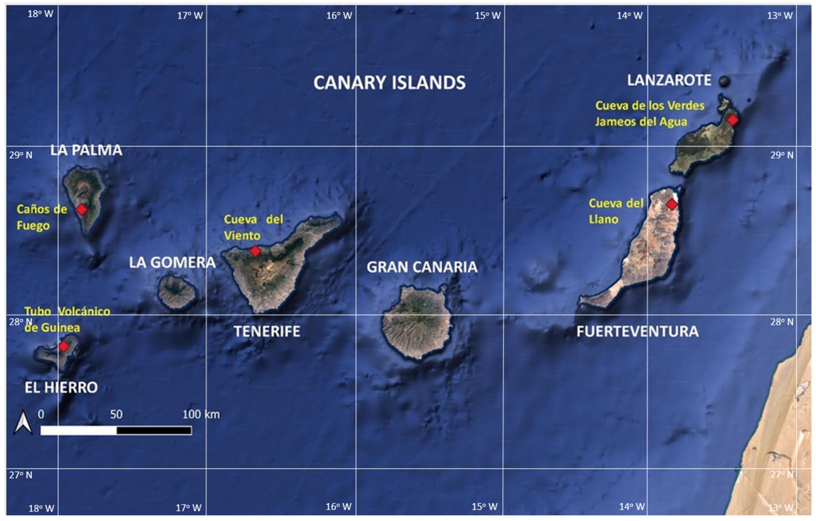
Numerous volcanic cavities or volcanic tubes have been identified in the Canary Islands as a result of the intense volcanic activity of the islands since their formation 20 million years ago [
16]. Of these, only the following are currently exploited as tourist caves: Cueva del Llano (Fuerteventura island), Cueva de Los Verdes and Jameos del Agua in Lanzarote, Cueva del Viento (Tenerife island), Caños de Fuego (La Palma island), and Tubo Volcánico de Guinea (El Hierro island) (
Figure 1).
Because tourist caves are visited daily by tourists and workers, a protocol for their effective and safe management is established in this study. There is an important group of workers inside the caves, such as guides and maintenance personnel [
17]. The workers are more exposed than tourists to the natural dangers that affect volcanic caves, since their time spent inside the caves is much longer. Workers work eight hours a day for five days a week. Tourists stay inside the cave for a maximum of two hours during a single visit per year. The risk to tourists is much lower because exposure to natural hazards is almost anecdotal [
18].
Subway ecosystems are highly susceptible to anthropogenic pressures on all their components, with synergistic impacts, often with consequences that are difficult to predict [
19]. Cave tourism may be responsible for altering the biotic component, affecting both the fauna and microflora inhabiting the caves, and also for changes in abiotic conditions (increased temperature and CO
2 concentration) or the introduction of pollutants.
However, the tourist activities practiced in the volcanic caves of the Canary Islands do not pose a threat to the stability of the cave, since they are carried out respecting the geomorphological integrity of the cave.
Occasionally, in order to adapt a cave as a tourist resource, it may be necessary to create accesses or eliminate interior obstacles to facilitate the transit of visitors, which implies modifications to the original morphology of the cave. In these cases, the stability of the cave may be affected if the appropriate protocols for geomechanical study of the rock massif are not applied when designing the necessary interventions.
Furthermore, this study only addresses tourist volcanic caves that have formed as volcanic tubes in the heart of basaltic lavas and which have a longitudinal extension and a considerable subterranean development. There are other types of volcanic caves that are also visited by tourists and residents in the Canary Islands, such as those that were inhabited by the primitive aborigines of the islands, but which do not have a linear underground development. These caves, which appear as large hollows on the surface of the slopes of the ravines, excavated by the aborigines in the soft rock levels or formed by natural erosion, and which were intended for habitation, religious, or mortuary use, are not covered in this work.
2. Materials and Methods
Studies of the structural stability of volcanic cavities are based on whether the characteristics of the rock mass allow the cavity to remain stable. This depends on several factors: the properties of the rock mass, the span or width of the cavity, the type of excavation, and the method of excavation [
20]. The present case is different, as the cavity has not been excavated but formed by natural processes; so, the approach was reduced to the analysis of two factors: the morphology and dimensions of the cavity and the geomechanical conditions of the rock mass.
In order to successfully address the structural stability study of a volcanic tube, it is advisable to undertake the following phases: (i) geological–geomorphological survey and identification of instabilities, (ii) geomechanical characterization of the cavity materials, and (iii) geomechanical analysis and stress–strain model.
- (i)
Geological–geomorphological survey and identification of instabilities
A detailed field inspection of the cavity should be conducted along its length, in order to determine the interior and exterior outcropping materials and detail its dimensions [
21]. Based on a geological–geomorphological mapping of the gallery, the different genetic units that have given rise to the current configuration of the cavity’s galleries must be distinguished.
In this phase, it is very important to have a topographic survey of the volcanic tube. The application of 3D laser scanning systems, with millimetric resolution, is becoming more frequent for the geospatial control of tunnels, mines, quarries, and all types of infrastructures, proving to be a very effective technique. For this reason, obtaining 3D point clouds for monitoring the stability of volcanic tubes in the Canary Islands has been a success [
22,
23,
24].
It is important to know the exact thickness of the materials between the cave ceiling and the surface, as well as the cave layout on the surface. This is necessary to be able to establish which activities and infrastructures on the surface are compatible with the structural stability of the cavity. For this, in addition to 3D scanning, a topographic survey of the interior of the cave must be carried out, subsequently transferring the coordinates of the layout from the interior to the surface [
25,
26].
In order to undertake this study, the following tourist caves in the Canary Islands were visited, where the types of existing instability and their possible evolution were observed and identified: Cueva del Llano (Fuerteventura), Cueva de los Verdes and Jameos del Agua (Lanzarote), Cueva del Viento (Tenerife), and Tubo Volcánico de Guinea (El Hierro). The cave located on the island of La Palma could not be visited due to the eruption of the Cumbre Vieja volcanic edifice in 2021. A large amount of pyroclasts (ashes) were emitted, which clogged some of the cave entrances (jameos). Instead, reconnaissance campaigns were carried out in a nearby cave, Cueva de los Palmeros.
The Cueva del Llano on the island of Fuerteventura is the oldest volcanic tube in the Canary Islands, with an age of approximately one million years. It has a length of 648 m and was formed from a large lava lake created during the eruption of the Montaña Escanfraga volcano [
27]. Its entire length can be visited.
The Cueva del Viento on the island of Tenerife is a set of volcanic tubes formed in the basaltic lavas of the first eruptive phase of the Pico Viejo volcano, which is located next to the Teide volcano. It was formed about 27,000 years ago, and its length reaches just over 18 km, one of the longest in the world and the longest in Europe [
28]. Only 180 m are exploited as a tourist resource.
The Cueva de los Verdes and Jameos del Agua correspond to two different sections of the same volcanic tube formed from the eruption of the Corona volcano on the island of Lanzarote, which took place approximately 21,000 years ago [
29]. It is a tube of about 7.6 km in length, reaching a maximum diameter of 25 m. Only a 1.5 km stretch can be visited as a tourist activity.
The Guinea Volcanic Tube on the island of El Hierro is a small gallery of about 100 m in length, the product of basaltic lava flows emitted by the El Golfo infill volcanism approximately 15,000 years ago [
30]. All its extensions can be visited.
The Cueva de los Palmeros on the island of La Palma is a volcanic tube that originated in the flowing basaltic lavas emitted by the Fuego volcano in the Cumbre Vieja ridge in the south of the island. It has an approximate age of about 4000 years. Its length is 151 m, in a route with an average slope of 44° [
31]. It is not currently not open to tourism.
- (ii)
Geomechanical characterization of the cavity materials
The geomechanical characterization of the materials that make up the cavity makes it possible to obtain the geomechanical parameters of the geotechnical units involved, which are necessary for the geotechnical calculation and stress–strain analysis. Geomechanical classifications are empirical methods to evaluate the support of a cavity. To obtain the geomechanical parameters of the rock mass, one of the following geomechanical classifications must be used: Bieniawski’s RMR index [
32]; Barton’s Q-System [
33]; or Marinos and Hoek’s GSI index [
34].
- (iii)
Geomechanical analysis and stress–strain model
The deformation model of the rock mass, for the type of rock quality obtained in the empirical analysis, can be estimated according to the Hoek–Brown rupture [
35] following Equations (1) and (2):
where
σci: simple compressive strength of sound rock, representing the rock matrix without discontinuities,
GSI: the GSI index; when only the RMR index is available, the correlation GSI = RMR − 5 can be applied,
D: factor of alteration of the massif by the excavation process. D = O for cavities.
Equation (1) applies when σci ≤ 100 MPa, and Equation (2) applies when σci > 100 MPa.
The strength parameters of the rock mass define the rock failure criterion. The Mohr–Coulomb failure criterion is one of the most commonly used, and its fundamental parameters are the cohesion c′ and the angle of internal friction ϕ′. This criterion follows Equation (3):
where in addition to c′ and ϕ′,
τ: shear resistance;
σ′: normal stress.
In certain rock masses, however, it is more appropriate to apply the Hoek–Brown fracture criterion [
34], which is widely accepted and has been applied in many projects around the world, whose fundamental parameters are the simple compressive strength of the intact rock, the σci, and three empirical parameters called m, s, and a, according to Equation (4):
where
σ1 and σ3: major and minor principal effective stresses, respectively.
mb: is the reduced value of the intact material constant, mi. The relationship between both values is as shown in Equation (5):
where
mi: intact material constant, dimensionless;
D: alteration factor, dimensionless.
The parameters a and s are material constants and are obtained from Equations (6) and (7):
where D is the disturbance factor.
In addition to applying empirical methods (geomechanical classifications), stability studies can be completed with numerical methods, both finite element and finite difference, which allow the stability of the cavity to be defined much more precisely.
3. Structural Stability of Volcanic Caves in the Canary Islands
The Canary Archipelago is a group of oceanic islands of volcanic origin, with a length of about 500 km, consisting of seven major islands (El Hierro, La Palma, La Gomera, Tenerife, Gran Canaria, Lanzarote, and Fuerteventura) and six islets (Alegranza, Montaña Clara, Roque el Este, Roque del Oeste, La Graciosa, and Lobos). The islands are located northwest of the African continent, approximately 100 km from the Saharan coast, between 27°37′ and 29°25′ N latitude and 13°20′ and 18°10′ west of Greenwich (
Figure 1).
The islands and islets grew from volcanic activity from the ocean floor more than 4000 m deep. The emerged island surface covers 7446.6 km
2, unevenly distributed. The morphology of the islands is varied, with a great contrast between the abrupt landscape of the western islands and the smoother relief of the eastern islands [
36].
Different successions of lava emissions resulting from effusive and strombolian eruptions, as well as pyroclastic emissions originating from explosive eruptions (plinian, phreatoplinian, volcanic), form a landscape throughout the Canary Archipelago dominated mostly by lavas of different natures and pyroclastic deposits of varied compositions. It has been produced practically since the beginning of the subaerial volcanic activity of the Archipelago, which dates back to the lower-middle Miocene, approximately 20 million years ago [
36,
37,
38,
39,
40].
From a geochemical point of view, the volcanic rocks of the Canary Islands belong to the alkaline igneous series, in this case, associated with intraplate volcanism [
41]. This igneous series is formed by a sequence of rocks whose composition evolves from undifferentiated terms, represented by basalts, intermediate terms, represented by trachybasalts, and finally, more differentiated or evolved terms, represented by trachytes and phonolites. Basaltic lava flows are the geological units with the highest representation in the Canary Islands.
Volcanic cavities are subterranean spaces built naturally in basaltic rock units, as a result of the modeling carried out by the lava emitted in volcanic eruptions during its circulation on the Earth’s surface, generating the so-called volcanic tubes [
42]. The end result is a longitudinal tunnel-like cavity in a basaltic rock mass that is affected by a series of discontinuities typical of this type of rock. Although, in general, they are usually stable structures, these cavities can suffer occasional block falls or the total collapse of some sections of the tube as a result of the evolution of the aforementioned discontinuities [
43].
Unlike artificial tunnels excavated in basaltic massifs, volcanic tubes do not have support or lining systems to guarantee their structural stability, which does not mean that they are not necessary [
44,
45]. In fact, rockfalls inside volcanic cavities are normal events in the natural evolution of these structures.
The structural stability of volcanic cavities will depend on the geomechanical properties of the materials, their spatial arrangement, and their age, conditioned in turn by the formation mechanisms of the volcanic tubes [
46]. Therefore, the managers of these facilities must perform periodic inspections and studies of the stability conditions of the cavity, identify indications or signs of possible landslides, and thus anticipate the occurrence of any event of this type, adopting the appropriate solutions.
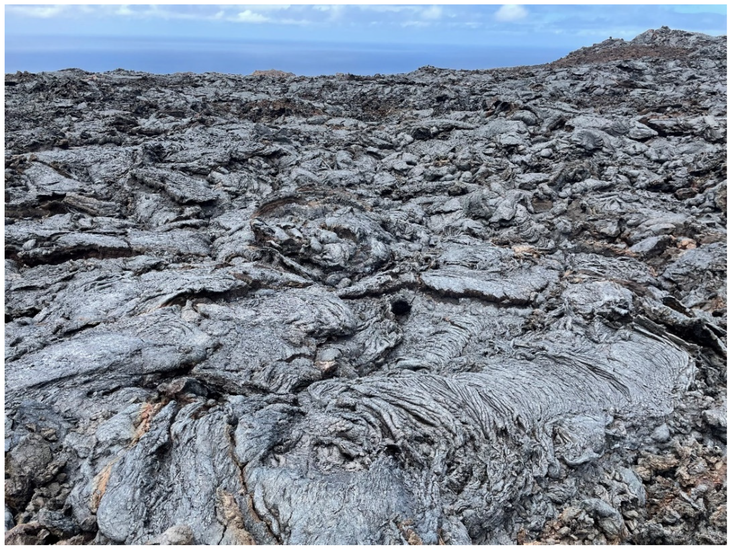
In terms of the morphology and structure, two basic types of basaltic lavas or flows exist: ‘aa’ or scoriaceous lavas and ‘pahoehoe’ lavas [
42]. Lavas with properties intermediate between these two types are called transitional lavas. The ‘pahoehoe’ lavas are more fluid than the ‘aa’ lavas, and when they cool and solidify, the surfaces are not scoriaceous but smooth, lobular, or cordate in shape (
Figure 2). Their interior structure is also different, presenting a very porous or spongy texture, a product of the small molds left in the rock by the numerous vacuoles, more or less spherical, of the gas contained in the lava [
47].
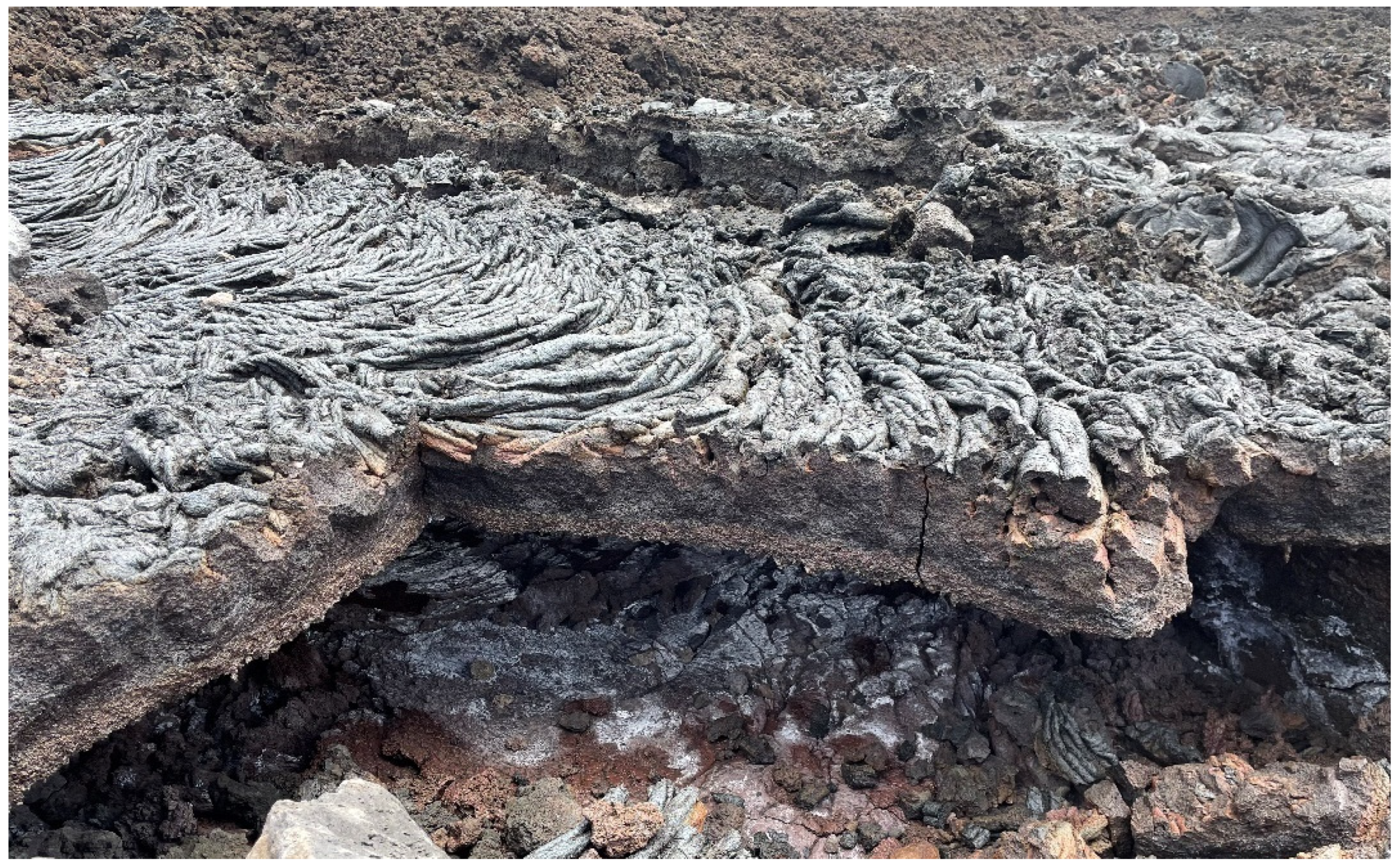
The internal structure of these lavas is formed by a tabular stacking of thin levels of basaltic rock. These layers (
Figure 3) are in turn affected by a vertical shrinkage and diaclases generated by the cooling of the lava, since the volume occupied by the liquid (lava) is greater than that occupied by the resulting solid (rock); the difference in volume is resolved by the formation of hexagonal prisms.
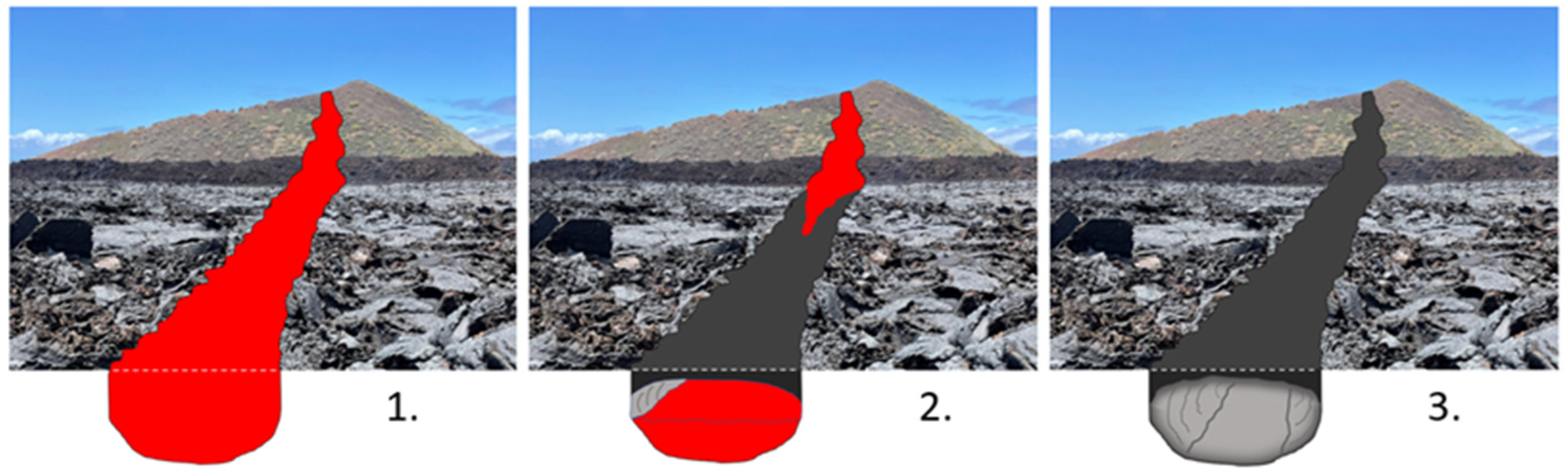
The formation of a volcanic tube can be summarized in three stages, as shown in
Figure 4: (1) There is a continuous flow for a long period of time of a ‘pahoehoe’ basaltic lava [
48], in such a way that the flow is channeled by the formation of solid edges on both sides of the flow, due to the cooling of the lava in contact with the air [
49]. (2) These edges grow as a result of lava splashes and form true walls of solidified lava that form the walls of the channel, while inside the channel, lava continues to flow; the surface also cools and solidifies on contact with the air, forming a rocky crust that will be the roof of the tube. (3) This crust will gradually thicken until it gives rise to a true slab of rock, which rests on the walls of the channel and which will form the roof or vault of the volcanic tube. When the lava flow ceases, the inside of the channel empties down the slope, creating the volcanic tube.
4. Results and Discussion
4.1. Classification of Volcanic Tube Instabilities
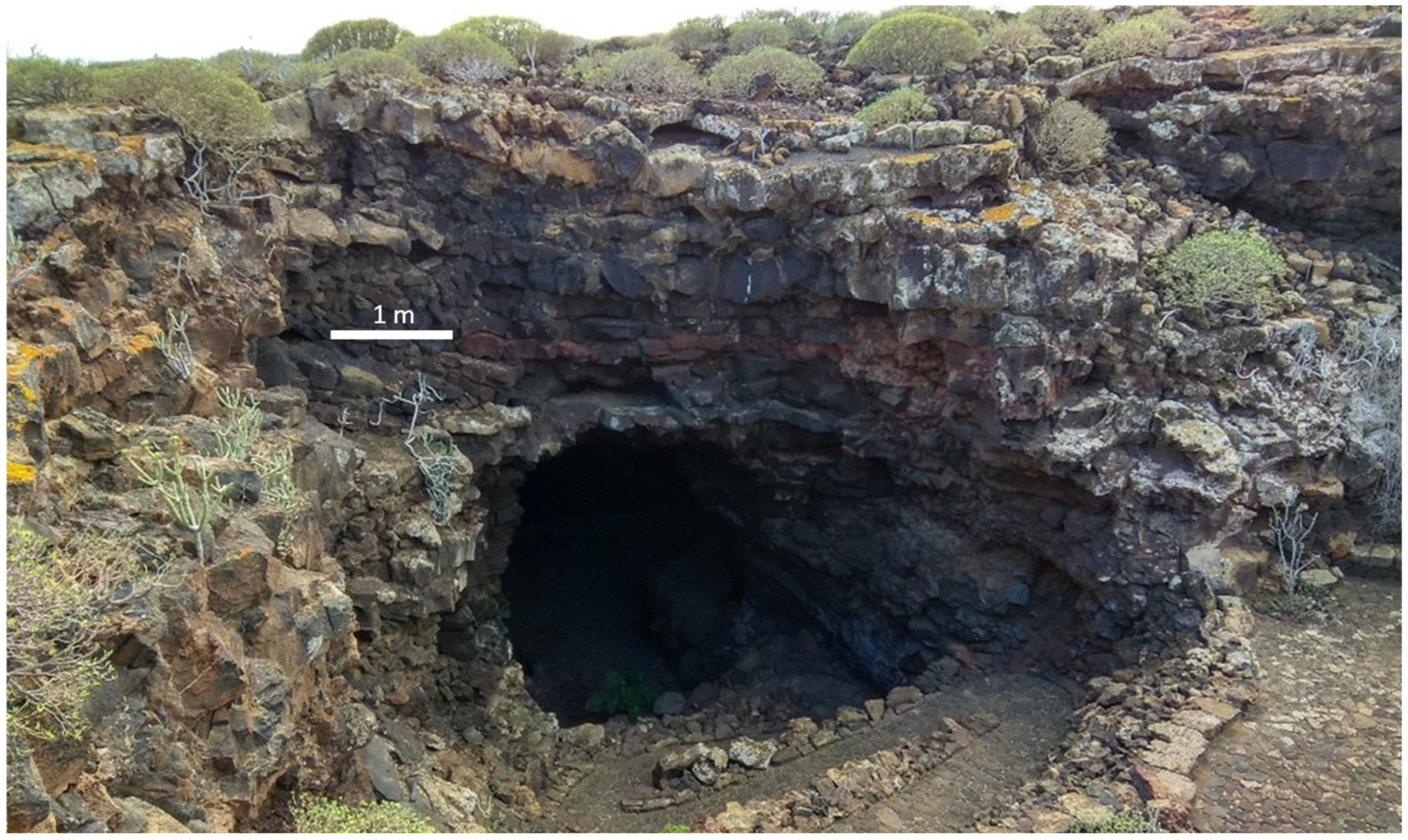
For this study, the instability processes of a volcanic cavity have been classified into three types, depending on the dimension of the process: micro-scale, meso-scale, and mega-scale. The micro- and meso-scale processes are the consequence of instability phenomena in the vault and walls due to the natural evolution of the rock mass that houses the cavity. These processes result in rock falls of different sizes and alterations of the surface of the cavity walls. Mega-scale processes refer to generalized collapses that develop on a geologic time scale; for such processes to take place, a general weakening of the geologic structure that constitutes the volcanic tube is required. However, global structural failure could occur after some extreme climatic event involving the infiltration of large amounts of water and/or the flow of large amounts of debris, a major earthquake, or highly invasive anthropogenic activities (excavation and construction). This process creates a jameo, a collapsed section of the tube that leaves the cavity open to the surface and creates access zones to its interior [
42].
Based on the inspection of numerous volcanic caves with instability problems in the Canary Islands and the analysis methodology described in the previous sections, a classification of types of instabilities for volcanic tubes, considering the scale of the process, is proposed below.
- (a)
Global Structural Instability
This mega-scale process refers to the possibility of collapse of a section of the vault, as occurred in the past in several of the caves studied (Cueva de los Verdes, Jameos del Agua, Cueva del Llano) and which gave rise to the present-day ‘jameos’ that have allowed access to these caves (
Figure 5). This phenomenon could be repeated in other parts of the tube, if the same geomechanical conditions were present that produced the structural failure of the vault and the formation of the ‘jameo’.
Although no signs of structural instability have been detected in the tourist caves of the Canary Islands in the sections that can be visited by tourists, it has been observed in other sections that these instabilities are usually associated with the highest/widest parts of the tube, regardless of the existing ‘jameos’.
The structure of the vaults seems to be made up of horizontal layers of several decimeters of basaltic rock, stacked in a tabular arrangement, affected by a shrinkage diaclasate. In order to determine the resistant capacity of these layers, studies are required to understand the stratigraphy and morphology of the materials between the vault and the ground surface, as well as the geomechanical properties of the rock masses involved [
50]. In order to obtain the most complete information possible, they should include detailed topographic surveys of the interior and exterior of the pipe, geophysical studies supported by surface mechanical soundings along the route of the pipe, and laboratory tests [
51].
- (b)
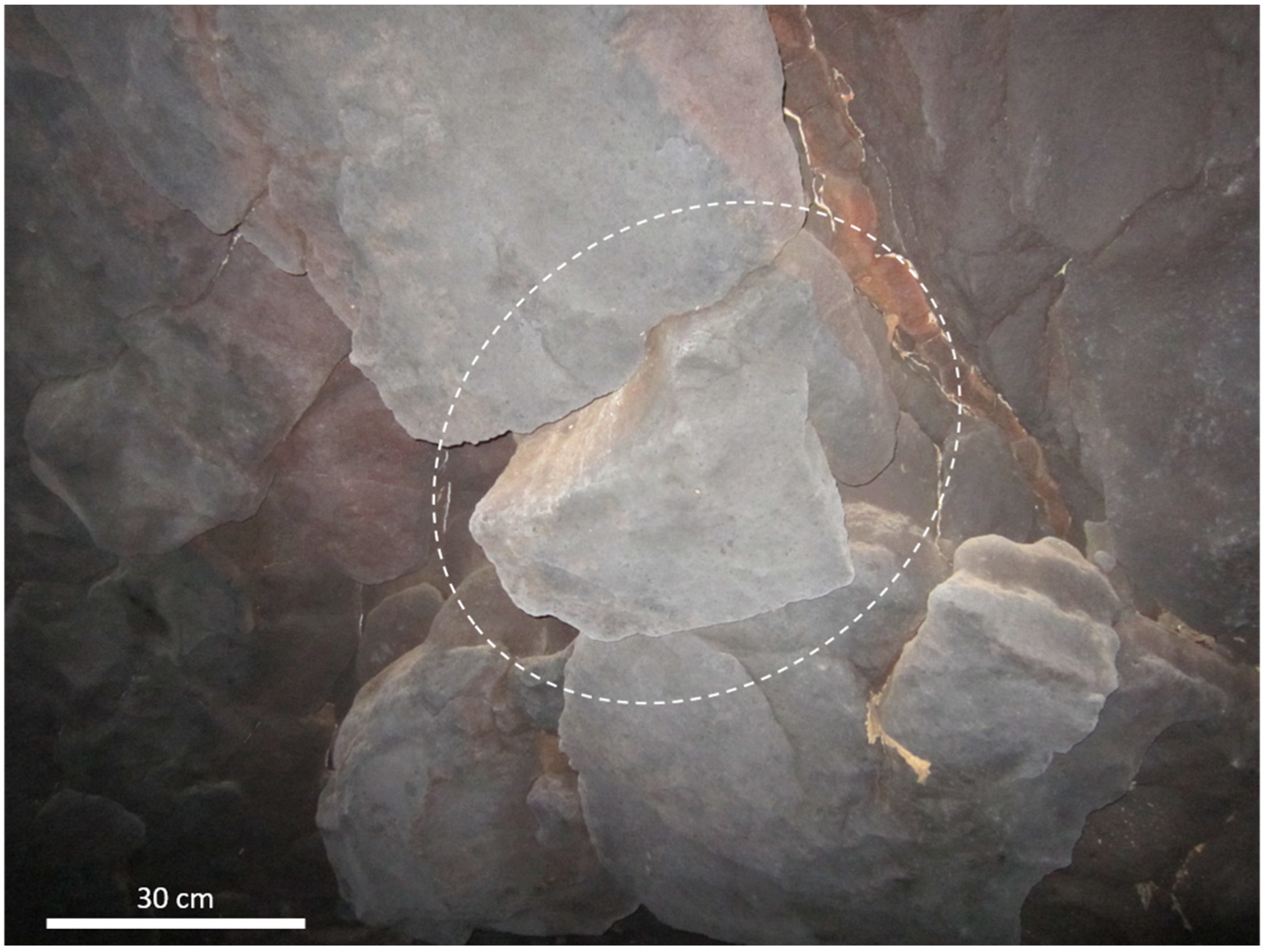
Point Instability Due to Falling Blocks
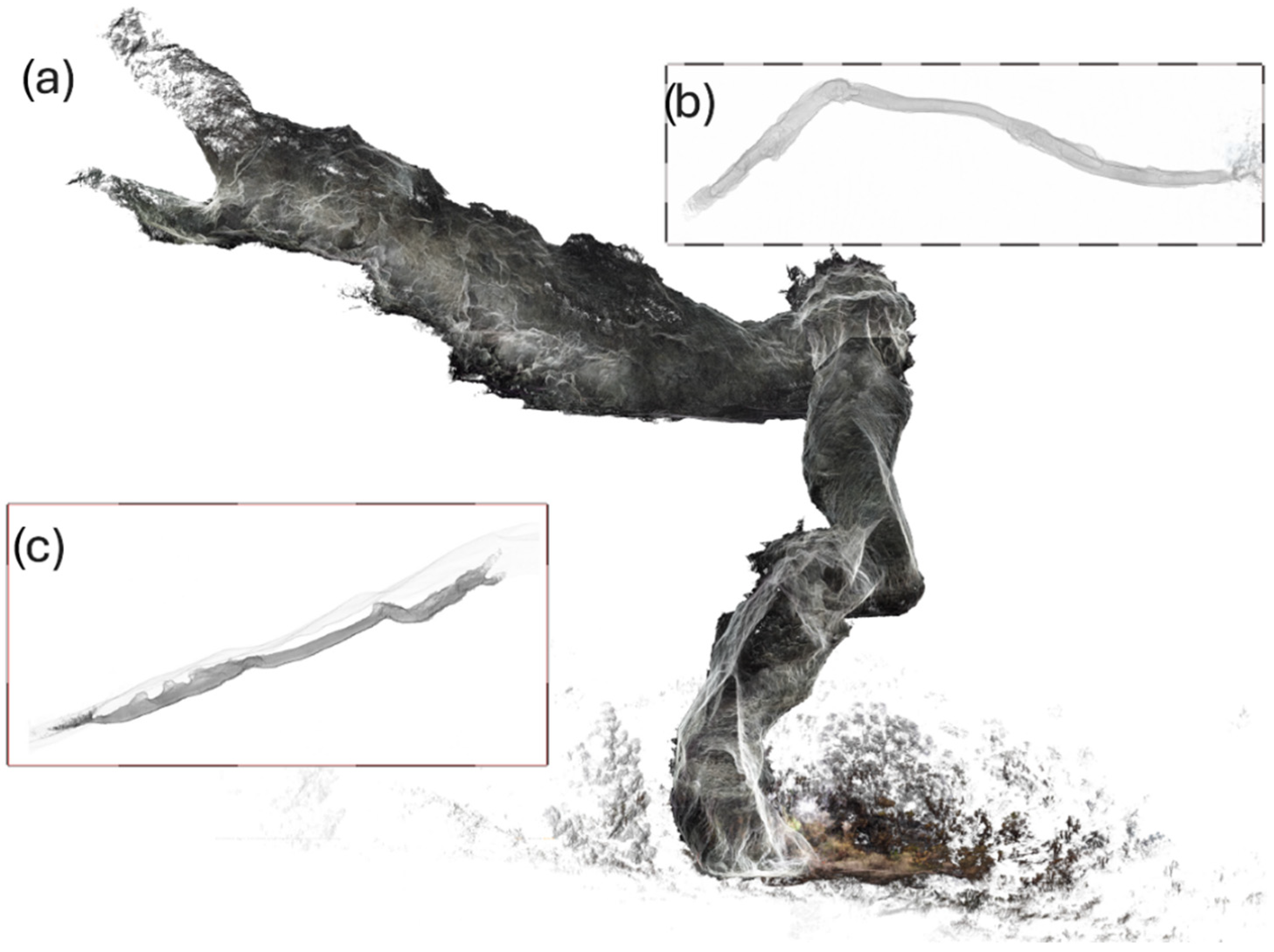
The confluence of the families of vertical retraction joints, with the horizontal joints of the contacts between the tabular lava levels, isolates blocks with shapes tending to hexagonal prisms that can also become detached (
Figure 6). This meso-scale instability is caused by detachment or a loss of block support [
52], as a consequence of one or more factors, such as (a) alteration of the block faces by fluid circulation, (b) convergent movements of the cavity due to the effect of gravity and the weight of materials on the vault, and (c) external factors such as seismic movements, and the dragging of soil and rock masses into the cavity.
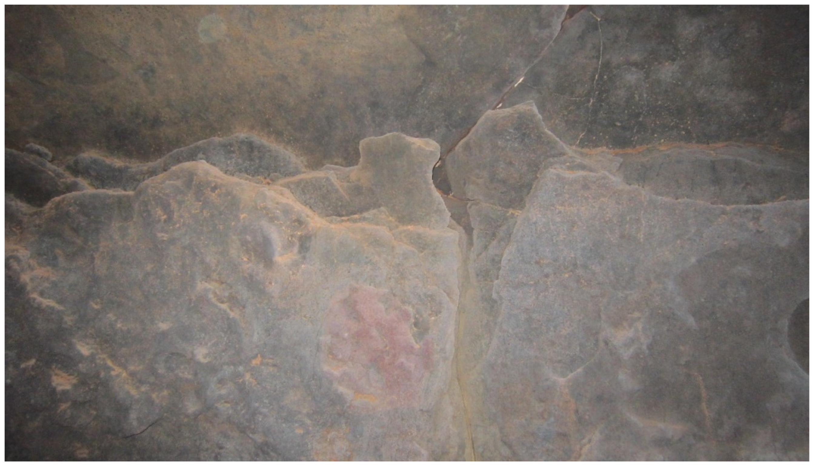
- (c)
Rock Bridge Instability
This type of meso-scale instability occurs when the detachment affects not only one block but a group of blocks. Over time, the layers of basaltic rock in the area of the vault of the tube undergo decompression and debonding, due to convergence processes typical of the fatigue of the material close to the cavity [
53]. In this case, rock bridges are formed (
Figure 7), which may eventually collapse.
- (d)
Point Instability Due to Slab Detachment
Another type of meso-scale instability common in volcanic tubes is centimeter-spaced flaking, with joints parallel to the inner arc of the vault, which favors the formation of slabs that can detach [
54] (
Figure 8).
- (e)
Surface Instabilities
These micro-scale instabilities are due to superficial alteration of the rock matrix, such as the oxidation of the rock, which causes the removal of small particles of millimetric to centimetric proportions [
55]. They do not pose a particular risk to people, since, given their dimensions and the height of their fall, they would not cause significant damage.
4.2. Geospatial Techniques to Control the Structural Stability of the Cavity
The application of 3D laser scanning to study the mega- and meso-scale behavior of the rock mass of volcanic tubes supports the geomechanical characterization of the rock mass by identifying, geometrically defining, and quantifying the rock discontinuities. In addition, this technique provides an accurate topography of the cave [
21,
22]. The application of this technique should involve the following phases and resulting products.
- (1)
First 3D reference scan or base scan
The first point cloud is obtained, which defines the digital model of the cavity [
56] and will allow comparison with future scans to detect displacements, deformations, or movements in the rock mass. For greater accuracy in geospatial analysis, it is recommended to scan at a rate of 2,000,000 points/second, with an average density of one point every 5 mm at 10 m and one point every 2 mm at 5 m.
- (2)
Cavity topography
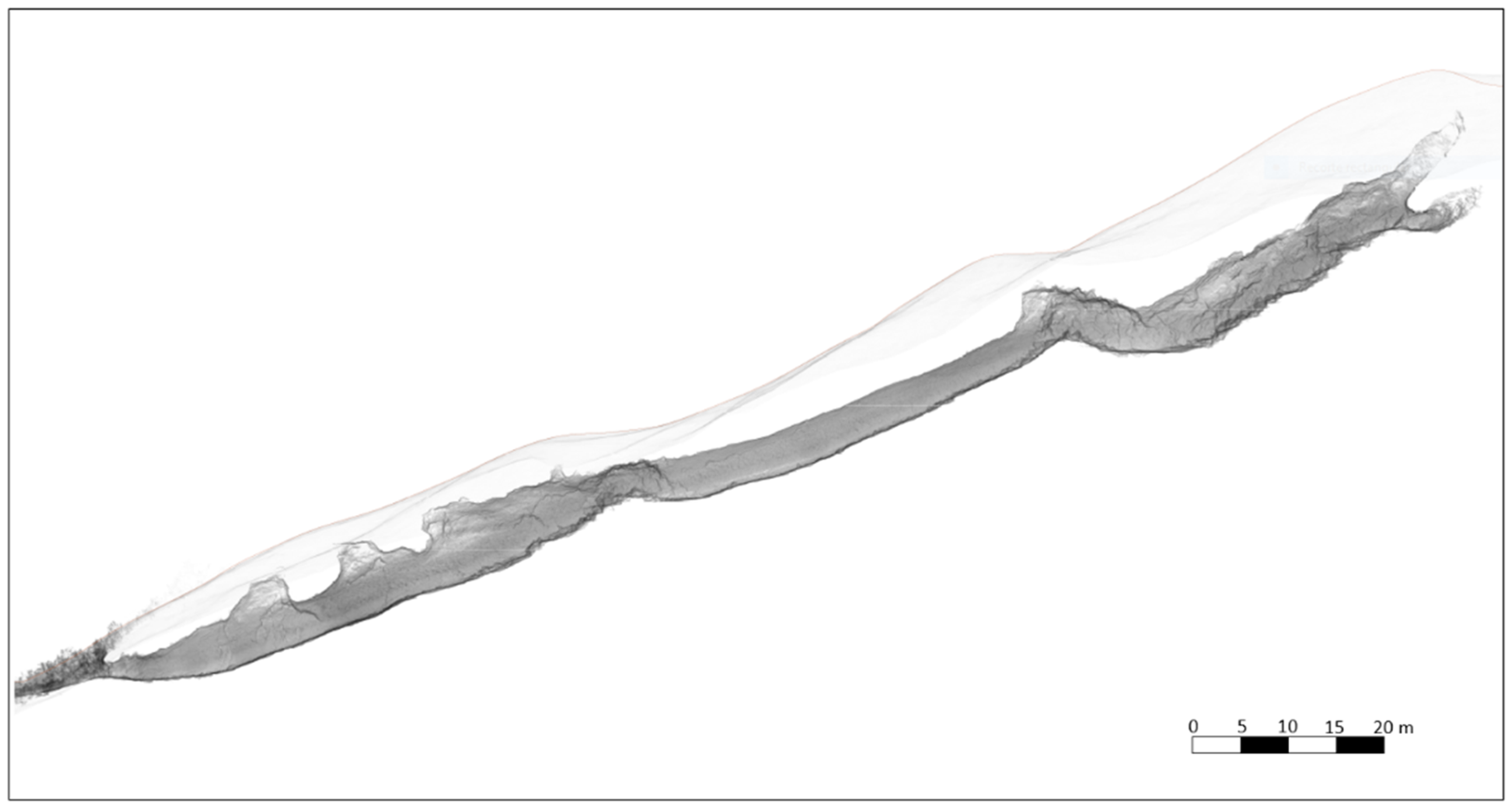
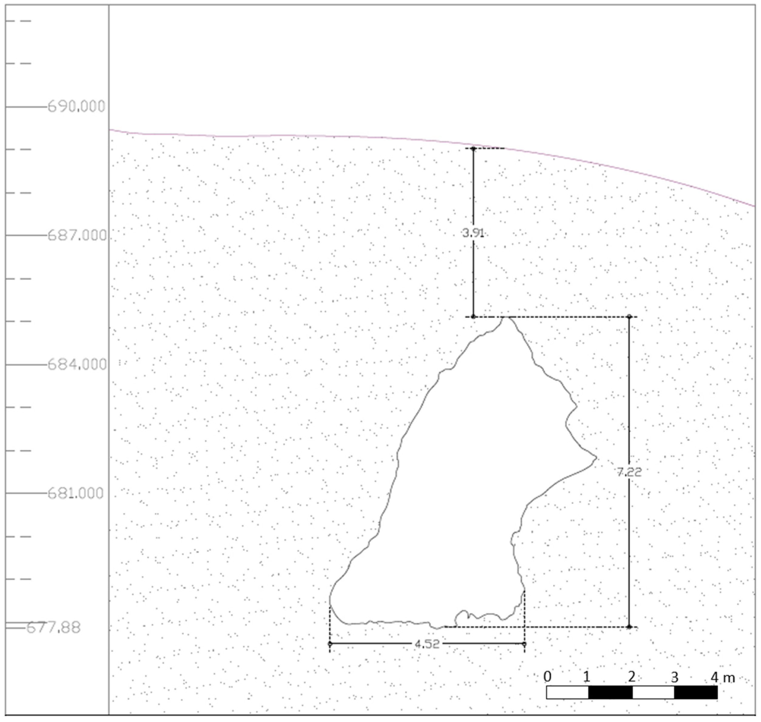
Simultaneous with the execution of the base scan, a topographic survey of the interior of the cave is carried out, subsequently transferring the coordinates of the layout of the interior to the surface and thus determining as accurately as possible the location of the projection of the tube on the surface. In this way, the thickness of the rock between the ceiling of the cave and the surface of the ground along the entire length of the route can be precisely determined (
Figure 9).
- (3)
Georeferenced 3D model
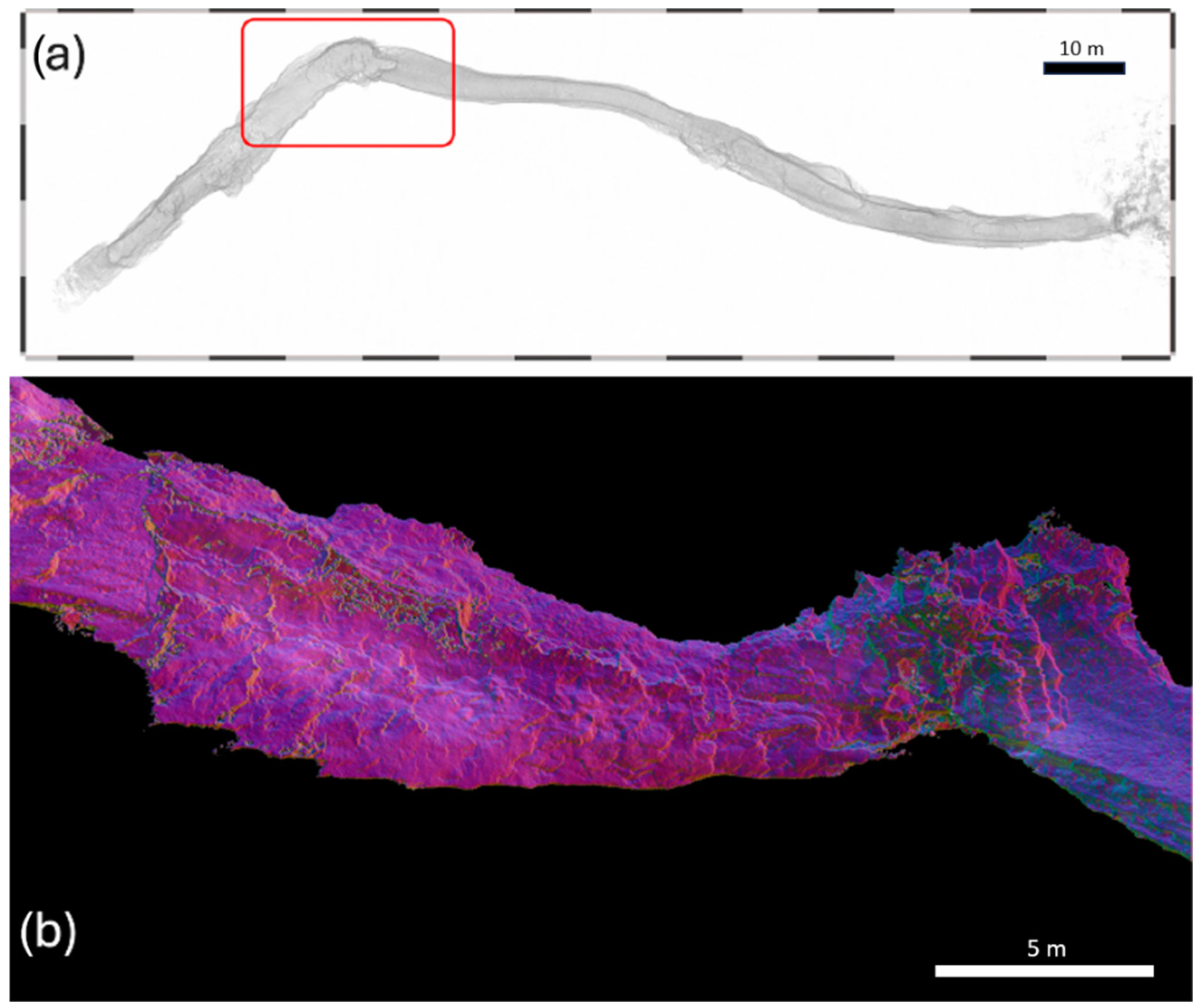
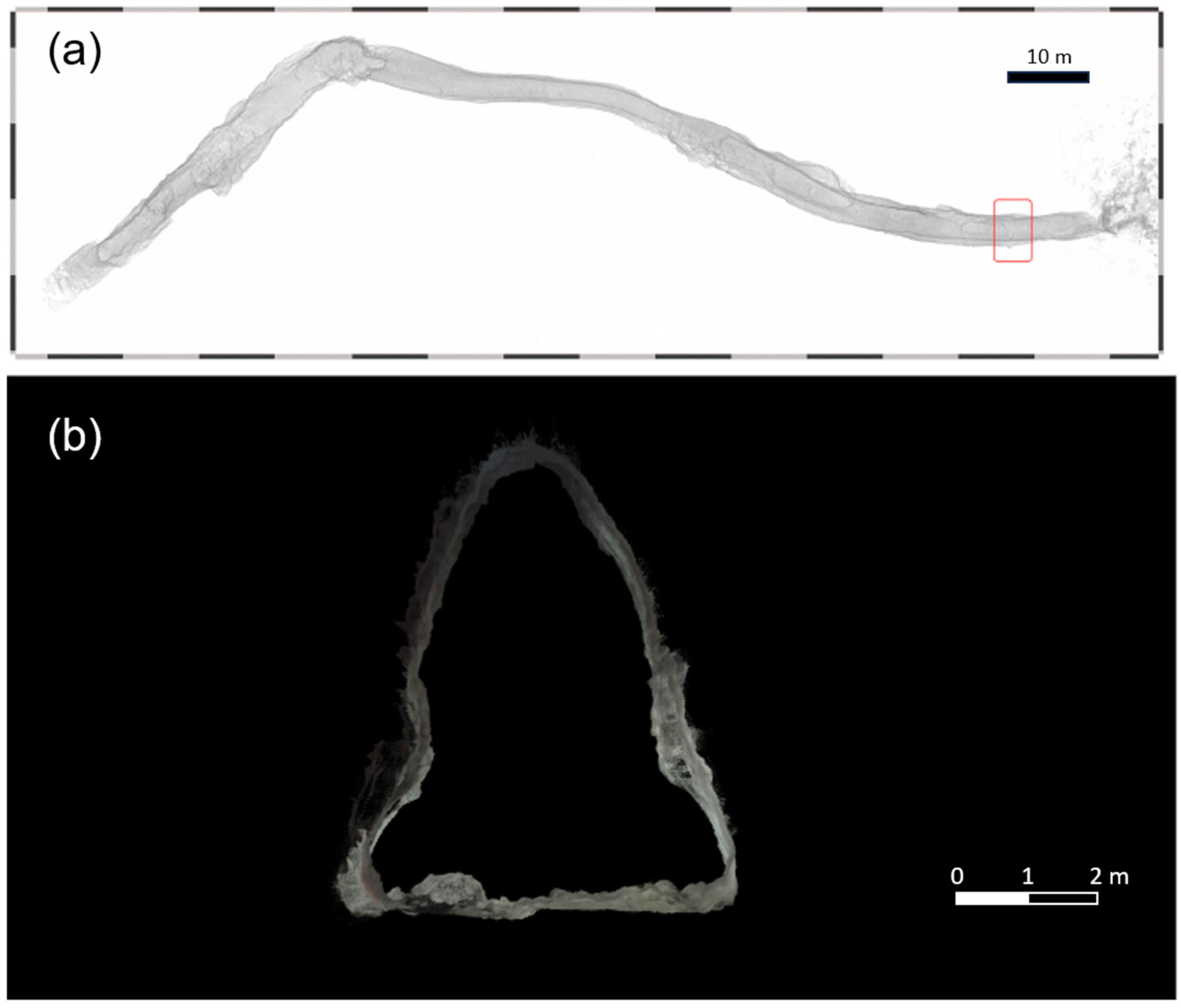
The result of this combination of scanning and topographic survey is a 3D model of the cave (
Figure 10) with UTM coordinates [
6]. From the treatment of the point cloud, it is possible to obtain, at any position of the pipe layout, as many sections as required for analysis of the internal stability of the pipe in terms of its geometry. These sections are also useful for studying the influence of external structures and communication and supply networks, located on the ground surface, which may compromise the stability of the cavity (
Figure 11).
- (4)
Geospatial study of discontinuities
From the data obtained by the point cloud, discontinuities are identified and measured, such as length, dips, openings, persistence, or spacing [
22]. The use of state-of-the-art scanners, such as the FARO Focus Premium 3D laser escanner or the FARO Orbis LiDAR/slam equipment used in this work, allows the collection of significant regarding the geospatial parameters of the interior of the cavity that refine the oscultation of discontinuities. From the values of the pulse intensity differences, we obtain different color fields where we can observe fissures and other hidden structures, imperceptible using other types of scanning or photogrammetry equipment. (
Figure 12). For graphical and geometrical analysis, programs such as Autodesk Recap or CloudCompareStereo, among others, can be used. In centimeter fissures, it is possible to measure the depth towards the interior of the rock mass (
Figure 13); this may enable knowledge of the thickness of the surface layers of the cave roof susceptible to detachment.
- (5)
Volumetric analysis
The dimensioning of instabilities from the point cloud is completed with the determination of the volume of blocks and layers susceptible to detachment and with the cubing of the volumes of material already detached. In addition, the volume of the interior of the volcanic tube can be calculated with high accuracy.
- (6)
Periodic scans
Periodic monitoring of the rock mass of the cavity consists of performing point clouds occasionally, depending on the degree of instability observed in the geological–geotechnical survey (1 month, 6 months, 1 year). Exceptionally, scans will be taken after extreme weather events, earthquakes of a magnitude involving any type of damage to buildings or infrastructure, and nearby invasive anthropic activities. The point clouds obtained will always be superimposed on the base scan. The objective of these comparisons is to determine whether the rock mass shows signs of instability mainly at the mega-scale and meso-scale.
4.3. Proposal for a Protocol for the Management of the Structural Safety of Tourist Volcanic Caves
The Decalogue of the Tourist Caves of Spain [
57] states that the “managers undertake to establish adequate management, control and surveillance mechanisms to guarantee the correct conservation and restoration of the subterranean environment”. Although no specific reference is made to the safety of people visiting or working in the cave, it is understood that, by ensuring the correct conservation and restoration of the subterranean environment, the structural stability of the cave is guaranteed [
58]. In this sense, it can be said that the managers of volcanic tourist caves in the Canary Islands must take responsibility for the structural integrity of the installation, in order to guarantee the safety of workers and visitors. In many of these caves, the managers have had to carry out some kind of intervention to guarantee structural stability throughout their period of operation as tourist facilities [
21].
Therefore, for managers, having a routine procedure to periodically verify that the stability conditions of the cavity are maintained is a protocol that would be highly desirable in tourist caves. The procedure proposed in this article would involve the following phases:
- (1)
Geological–geotechnical reconnaissance
An expert in the geology of volcanic environments and in geological engineering conducts the reconnaissance. The expert carries out a visual inspection of the interior of the cavity, detecting possible instabilities and recording data regarding the geomechanical properties of the materials. The expert applies minimally invasive techniques, such as the Schmidt sclerometer, to determine the impact rebound index, the geologist’s hammer to verify whether the blocks are loose or anchored, or ultrasound techniques to verify the existence of hidden cavities or discontinuities [
34,
50]. During this process, small fragments that have been removed during the application of the sclerometer and hammer should be removed, so they do not interfere in the subsequent topographic survey phase.
- (2)
Topographic survey of the cavity
The topographic base obtained must be of the highest possible quality and precision, since the aim is to identify any millimeter-sized element that is susceptible to mobilization on the interior surface of the cavity. Therefore, the application of a 3D laser scanner is highly recommended [
6,
24]. With this technique, it is possible to obtain a three-dimensional topographic model of the cavity in absolute coordinates and with an accuracy of 1–3 mm, which allows the evolution of the interior surface to be monitored over time. The scanning must be repeated occasionally, depending on the state of the cave, recommended annually or after the occurrence of unforeseen events (construction work, earthquakes, volcanic eruptions, floods).
- (3)
Instability mapping
This involves projecting the instabilities identified in the geological–geotechnical survey onto the topographic base obtained, in order to locate them and monitor their evolution each time the cavity is rescanned. This technique is eye-catching, so it can be shown to visitors as an additional attraction of the visit to the cave [
56].
- (4)
Analysis of instabilities and decision making
If, after a scan, significant movements are detected, or if minor blocks or fragments fall, indicating a major event, appropriate preventive measures must be taken; in any case, this will involve closing the affected section to the public.
- (5)
Contracting a geotechnical study of the stability of the cavity
When the circumstances of the previous point are met, this study should be contracted and must have sufficient scope to characterize the materials geomechanically, carry out the geomechanical analysis, and draw up the stress–strain model of the rock mass, in accordance with the proposed methodology, as well as to propose the technical solutions that guarantee the structural stability of the cavity.
- (6)
Implementation of technical solutions
These solutions must be compatible with the preservation of the natural environment of the cave, so that the rehabilitation and reinforcement treatments mimic, as far as possible, the rock massif. The use of metal bolts should be avoided, and fiberglass bolts should be used instead, mainly because of their greater resistance to erosion and greater durability over time. The use of conventional concretes and mortars should also be avoided, instead using epoxy resins of a predetermined color, with greater resistance and durability, which blend in better with the environment.
- (7)
Citizen Observation
This consists of encouraging the participation of visitors in detection of signs of instability during their visits to the caves, by taking photographs and videos and sending them to those responsible for stability control [
59]. In this case, the files can be sent by telephone messaging or e-mail provided on the information panels located at the entrance of the cave or in the interpretation centers near the cave.
The responsibility for geoconservation must be a shared task between managers and geotourists, as was highlighted at the IUCN (International Union for Conservation of Nature) congress held in Sydney (Australia) in 2014. There, it was stated that it is not possible for governments to assume all the costs of protecting the environment, so it is essential that the population also assumes responsibility for geoconservation [
60].
5. Conclusions
Structural stability problems affecting volcanic caves are the main problem faced by tourism managers in their day-to-day work of maintaining and preserving the physical integrity of the installation.
The intrinsic characteristics of the volcanic rocks that make up the cave give them a very particular behavior, which is important to know in order to tackle the problem of instability. In this study, these particularities have been uncovered, and the most appropriate tools for the study and analysis of these rock masses have been presented, which have been sanctioned by the practice of many years of application in volcanic cavities. In addition, the different types of instability that can occur in these caves are outlined, offering managers a tool to make a first identification and approach to the problem. This will allow them to be alert to danger and take the necessary preventive measures to ensure the safety of people (visitors and workers), until an expert technician carries out the relevant geotechnical study.
State-of-the-art geospatial techniques techniques have become one of the best as one of the best tools for monitoring the structural stability of cavities. Experience in the tourist volcanic caves of the Canary Islands has shown that applying a periodic monitoring system with a 3D laser scanner can be a very effective method of monitoring the stability of the rock massif, offering a guarantee of safety. As long as a reliable rock mass stability monitoring method is being applied and no instability results are obtained, it will not be necessary to act, which in turn, will contribute to maintaining the natural equilibrium.
Prevention is the best weapon available to the managers of tourist caves to anticipate the problems generated by natural hazards, hence the establishment of a protocol for the control of the structural stability of the interior of the cave, based on state-of-the-art techniques. This six-phase protocol can guide the manager from the first signs of instability to the resolution of the problem. A thorough geological–geotechnical study, carried out by an expert in volcanic geology, must be supported by a very precise topographic survey that allows linking the point clouds obtained by a 3D laser scanner to obtain an accurate digital model of the volcanic tube, completely georeferenced.
With these tools, the generation of instability maps and their analysis is facilitated, which will serve as the basis for applying the proposed methodology and obtaining the stress–strain model of the rock mass. With all this information, an intervention will be carried out in the cavity if necessary, applying minimally invasive and durable engineering techniques that mimic the terrain, in order to guarantee the visitor a real natural experience.
The responsibility for geoconservation should be shared between managers and geotourists. Geotourists play an important role in prevention and should be involved in monitoring and controlling the stability of the cavity, taking advantage of their environmental awareness. To this end, citizen observations are proposed, where the geotourist participates in monitoring by sending photos and videos of signs of instability, so that they can be analyzed by the managers of the tourist cave.
Due to the limited number of cavities studied, the results are not necessarily generalizable to the rest of the volcanic cavities of the Canary Islands or the rest of the planet, since the volcanic nature is intrinsically associated with the formation of subway channels with improbable layouts and capricious morphologies that condition the stability of the whole.


 ,
, 
