Article

Evaluating the Impact of Geoeducation Programs on Student Learning and Geoheritage Awareness in Greece

Department of Geology and Geoenvironment, National and Kapodistrian University of Athens, Panepistimiopolis, 15784 Athens, Greece
*
Author to whom correspondence should be addressed.
Geosciences 2024, 14(12), 348; https://doi.org/10.3390/geosciences14120348
Submission received: 28 August 2024 / Revised: 13 December 2024 / Accepted: 15 December 2024 / Published: 18 December 2024

Abstract

:
In recent years, multiple efforts to promote geoscience and geoenvironmental awareness have highlighted the need for geoeducation. This article explores the importance of integrating geoeducation into the Greek curriculum for promoting a deeper understanding of geosciences. The method used is primarily based on a mixed-methods approach, covering both qualitative and quantitative data. A preliminary assessment revealed a lack of information on the conceptual framework of geosites and geoparks. Following this, a geoeducation tool was developed to introduce the basic principles of geoeducation. The evaluation showed a significant increase in understanding and a heightened desire for further knowledge on geoeducational topics. To address current deficiencies, effective integration of this geoeducational tool requires comprehensive teacher training and curriculum reform. Promoting geoeducation through school programs is critical for creating a more informed, responsible, and sustainable society. This paper advocates policy changes and educational initiatives to firmly integrate geoeducation into the Greek educational system.

1. Introduction

Over the past twenty years, academic researchers have focused their efforts on issues related to geoconservation and geological heritage [1]. The term “geological heritage”, or “geoheritage”, is consistently associated with the broader concept of natural heritage [2]. In this context, the geoscientific community has undertaken efforts to record, evaluate, and highlight areas of significant geological interest. Key milestones in this effort are the Convention for the Protection of the World Cultural and Natural Heritage, held in Paris in 1972, and the International Declaration on the Rights of the Memory of the Earth, held in Digne in 1991 [3]. These events laid the foundations for a European initiative aimed at the protection of geoheritage and geodiversity, which led to the creation of the European Geoparks Network (EGN) in 2000 for the systematic promotion of geodiversity protection and conservation processes [4]. In 2004, the Global Network of Geoparks was created with the aim of enhancing the appreciation of geological heritage among both geoscientists and the public and promoting sustainable development in the areas hosting these geoparks [5]. These initiatives have given impetus to the development of geoeducational programs and activities.
In addition, a variety of activities closely related to geoeducation and geotourism are emerging, based on the principles of sustainability and sound environmental management [6,7]. These activities aim to preserve the geoenvironment, geological heritage, and geodiversity of geologically important areas. Geotourism is becoming increasingly popular as an alternative form of tourism that emphasizes social, cultural, environmental, and economic sustainability. This approach seeks to benefit not only society and its inhabitants but also the environment itself.
However, geoeducation in Greece is still in an early stage. Few geoeducation programs take place in schools, partly because of the structure of existing courses in primary and secondary education. Furthermore, these programs are often taught by non-specialist staff within the geography curriculum and occasionally during special subject units [8]. In secondary education, especially in the first and second years of upper secondary education, geology–geography are taught for only one or two hours a week. These curricula do not place sufficient emphasis on geoheritage, the paleontological significance of specific geological areas, or fossil sites that illustrate the evolution of our planet [9]. As a result, Greek students receive limited education in geological and geoenvironmental issues, leaving them with an insufficient understanding of the geosciences that are critical to everyday life [10,11]. According to a statistical study by Georgousis et al. [12], most Greek students do not have sufficient knowledge and understanding of geoheritage and its importance. This research highlights the need to introduce and implement geoeducation, not just environmental education. It is also vital to have well-trained staff in the Greek education system who can effectively communicate the importance of geosciences and geoheritage, which reflect the evolution of our planet.
Thus, geoeducation, which is an educational approach that focuses on teaching and learning about Earth systems, including geology, geography, the environment, and the various processes that shape our planet [2], is vital for the development of a society that understands and respects the planet. By integrating geoeducation into the national curriculum, Greece can ensure that students not only acquire basic scientific knowledge but also develop a strong moral framework to guide their interactions with the ecosystem.
The following primary objectives of this research are twofold: to assess the impact of a geoeducation program on students’ understanding and interest and to explore the steps necessary to integrate geoeducation into the Greek education system.
To achieve the first objective, a pre-test is administered to assess students’ initial awareness and understanding of geosites, geoparks, and geological heritage. A geoeducation program will then be developed and implemented, focusing on teaching the basic principles of geoeducation with an emphasis on the importance of geoheritage and sustainable environmental practices. A post-test will then be conducted to assess the effectiveness of the program in improving students’ understanding of geoeducation concepts and their intention to expand their knowledge in this area. Regarding the second objective, based on the findings of Georgousis et al. [12], who identified significant gaps in students’ knowledge and understanding of geological and geoenvironmental issues, this study will aim to develop practical recommendations to address these weaknesses. This includes developing comprehensive teacher training programs and designing curriculum changes to ensure that geology is effectively integrated into primary and secondary education. The aim of the study is to promote a more informed, responsible, and sustainable society by increasing geoethical awareness and education.

2. Methodology

2.1. Research Design

The present study uses a mixed methodological approach, incorporating both qualitative and quantitative research methods, to provide a comprehensive understanding of the need for geoeducation in Greece and to assess the impact of a geoeducation program on student understanding and interest. In particular, an exploratory sequential design was used, whereby qualitative data were collected first to identify themes related to geoeducation and geoethical awareness [13]. The exploratory sequential mixed approach consists of the following two phases: qualitative data collection and analysis, followed by a quantitative phase based on the qualitative findings. Statistical analysis is frequently included in the quantitative phase, but this varies depending on the research objectives and data type. While advanced statistical methods like paired-sample t-tests and factor analysis of-fer valuable insights, we focused on descriptive quantitative analysis. This approach aligns with our primary goal of identifying trends and changes in knowledge following the program. Descriptive statistics, such as frequency distributions and comparisons, provide clear and valid insights for evaluating educational interventions. The qualitative phase includes thematic or content analysis, whereas the quantitative phase employs tools such as surveys or tests. Based on the qualitative findings, we developed and validated quantitative instruments, such as questionnaires and assessment rubrics.
The integration occurred at the instrument development stage, where qualitative insights informed the formulation of the quantitative questions, and in the interpretation phase, where qualitative and quantitative results were synthesized to provide deeper insights. This approach allows for a more robust and nuanced analysis, combining the advantages of both qualitative and quantitative data [14,15].
Therefore, prior to conducting quantitative research, we conducted qualitative research to gather in-depth information about participants’ understanding, attitudes, and perceptions related to geoeducation. This phase aimed to inform the design of our quantitative instruments and ensure that the research questions were grounded in the real experiences and perspectives of the target audience.
We used purposive sampling [16] to select a diverse group of 30 participants, including secondary school teachers, students and community members from Kalymnos and Nisyros. This diversity allowed us to capture a wide range of views on geoeducation. We used semi-structured interviews and focus groups as the main data collection methods. The semi-structured interviews provided a flexible framework that allowed participants to express their views on geoeducation and its importance in the local context. In addition, focus groups were organized to facilitate discussion among participants, encouraging them to share and reflect on others’ ideas. These discussions provided information about shared beliefs and attitudes toward geoeducation. Interviews and focus groups were transcribed and analyzed using thematic coding. This analysis identified key themes, such as awareness of geoeducation, perceived barriers to integrating geoeducation into the school curriculum, and the potential benefits of geoeducation programs for local communities. Awareness of geoheritage was a major issue, with participants discussing their awareness of geological monuments, their significance, and the role of geoeducation in spreading this information. Geoethical concerns were also raised, emphasizing the ethical aspects of human contact with geological monuments, such as preservation, responsibility, and sustainable practices. Another key subject was participants’ understanding of geosites and geoparks, which highlighted their basic knowledge and attitudes about local geosites and geoparks, as well as their educational and touristic significance. Participants noted perceived barriers to geoeducation, such as a lack of resources, training, or knowledge, which hampered the incorporation of geoeducation into the formal curriculum. Finally, discussions about the potential benefits of geoeducation programs focused on how participants believed geoeducation may improve students’ awareness of environmental issues while also contributing to community development through geotourism.
Findings from the qualitative phase informed the design of the quantitative research, highlighting specific areas of interest and concern. For example, the qualitative data revealed a lack of awareness of specific geoeducation terms, which led us to include questions in the survey that assessed participants’ knowledge of these terms. In addition, insights into participants’ attitudes toward environmental management and geotourism were used to improve the research focus on these aspects of geoeducation.
Quantitative methods, including pre- and post-tests, are crucial for measuring changes in students’ knowledge and interest in geoeducation topics. The pre-test establishes initial awareness, while the post-test evaluates program effectiveness.
The research process was based on five stages (Figure 1). First, the participating school units were selected. Specifically, three high schools were selected from the island of Kalymnos and one from the island of Nisyros. The choice of these areas was not accidental, as both areas are of intense geological interest for different reasons [17,18]. Then, in the second phase, the pre-test was carried out, which consists of 25 questions, mainly of a closed type, in order to evaluate the existing situation. The main purpose of the pre-test was to record the situation regarding the knowledge background in geological courses that exists in different school units of secondary education. In the third phase, a geoeducational program was conducted to teach some basic geoeducational concepts. Then, in the fourth phase, the post-test (consisting of 25 questions) was conducted, which established the positive contribution of the training program, as well as the desire for further learning on such topics. In the fifth phase, the pre- and post-tests were recorded and analyzed. It should also be noted that the main purpose of the present research is the analysis of the quantitative results obtained from the pre- and post-tests and not the results of the answers given by the participants during the implementation of the geo-educational program. This is because the main purpose of the geoeducational program was to promote concepts and enhance the participants’ knowledge background, and not to evaluate the success rate of the answers.
In addition to the mixed-methods methodology, this study’s quantitative analysis is embedded in a program assessment model to analyze the geoeducation program’s effectiveness.
This evaluation framework allows for a structured approach to understanding the overall effectiveness of the geoeducation program by not only measuring knowledge gains through pre- and post-tests but also examining attitudinal changes and how these outcomes align with the program’s broader goals. Through this lens, the study sheds light on how geoeducation might influence both cognitive and affective domains in participants, as well as the possibility of long-term engagement with geosites and environmental stewardship.
It should also be mentioned that permission was requested from the Ministry of Education and the competent Directorate of Secondary Education of Dodecanese to conduct the research. Also, if a participant did not want to answer a question, this possibility was given, respecting the freedom of choice.

2.2. Educational Methodology

The geoeducation program designed for this study employed a combination of inquiry-based learning (IBL), place-based education, hands-on geological fieldwork, and digital tools to immerse students in geological concepts and foster critical thinking, problem solving, and environmental awareness. This multifaceted educational framework ensured that students were active participants in their learning, aligning with constructivist principles that promote direct engagement with material and environment [19].

2.2.1. Inquiry-Based Learning (IBL)

The program’s foundation was inquiry-based learning, which encouraged students to actively engage in learning by asking questions, investigating solutions, and constructing knowledge. In the context of geoeducation, IBL helped students explore their local geological environment, delve into topics such as Greece’s geological history and volcanic activity, and understand the significance of geosites and geoparks. Following the scientific method—from hypothesis generation to data collection, analysis, and conclusion—students were encouraged to take ownership of their learning. Rather than passively receiving information, they actively applied geological knowledge, fostering skills in critical thinking and scientific inquiry [20].

2.2.2. Place-Based Education

With the unique geological features of Kalymnos and Nisyros, the program integrated place-based education to connect students’ learning to their local environment and community. This approach allowed students to relate abstract concepts to their real-world surroundings. Through field trips to local geosites and geoparks, students engaged directly with geological features, reinforcing classroom learning and strengthening their sense of environmental stewardship. They also explored the relationship between their community and its geological history, learning about the role of geotourism and participating in local conservation efforts, which tied geology to broader social and economic issues [21].

2.2.3. Hands-On Geological Fieldwork and Digital Tools

Fieldwork was a critical component, enabling students to apply classroom knowledge in real-world settings. Students identified rock types, measured geological formations, and interpreted features through data collection and analysis exercises. Collaborative problem-solving tasks, like mapping exercises and erosion studies, encouraged teamwork and communication skills. Additionally, digital tools, including interactive maps, virtual tours, and data visualization software, complemented fieldwork and in-class learning. These tools enabled students to explore remote geosites, visualize geological processes, and analyze fieldwork data, thereby enhancing their understanding and engagement [22].

2.2.4. Bloom’s Taxonomy and Modern Pedagogical Approaches

Bloom’s Taxonomy served as a foundational framework, guiding the progression from basic knowledge acquisition to higher-order cognitive skills. In the initial stages, students engaged with key geological concepts through interactive quizzes and classroom discussions, while fieldwork and data analysis addressed the application and analysis stages. In collaborative projects, students reached the evaluation and creation stages, proposing conservation strategies and designing educational materials to raise awareness of local geological heritage. By incorporating IBL, place-based education, and Bloom’s Taxonomy, the program enabled students to move from foundational knowledge to complex understanding and application, creating a comprehensive geoeducation experience [23,24].

2.3. Description of the Geoeducational Program

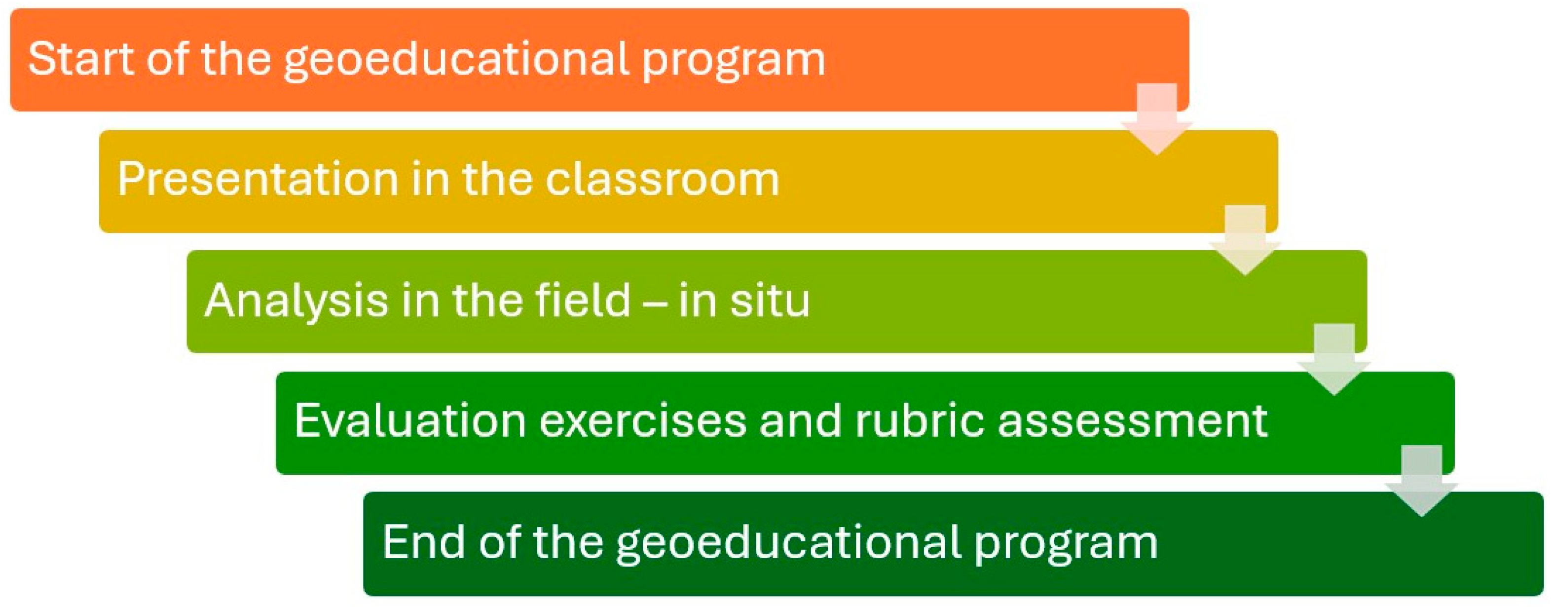
A geoeducational program, “Exploring the Wonderful World of a Limestone Island”, was developed to engage high school students and teachers with the geological heritage of Kalymnos. This comprehensive program unfolds across the following three distinct phases: classroom presentation, field analysis, and evaluation exercises, as illustrated in Figure 2. By progressing through each stage systematically, participants build a strong foundation in geoeducation, gain practical field experience, and assess their learning outcomes.
The program begins with an introductory classroom session aimed at providing participants with foundational knowledge of geological concepts, particularly focused on cave formation and geological processes. Interactive presentations, coupled with visual aids, are utilized to ensure participants grasp the fundamentals of geoeducation and appreciate the importance of geological heritage and geoconservation. This phase creates an interactive environment in which students and teachers can engage in discussions, fostering deeper understanding.
Following the classroom session, participants embark on a field trip to local geological sites, where they can directly observe and analyze geological features. This hands-on experience is instrumental in helping them apply theoretical concepts to real-world settings. Tablets and digital tools are integrated into the fieldwork to enhance learning, enabling participants to document observations and collaborate effectively. This phase not only reinforces previously covered material but also cultivates essential skills such as critical thinking, collaboration, communication, and digital competency.
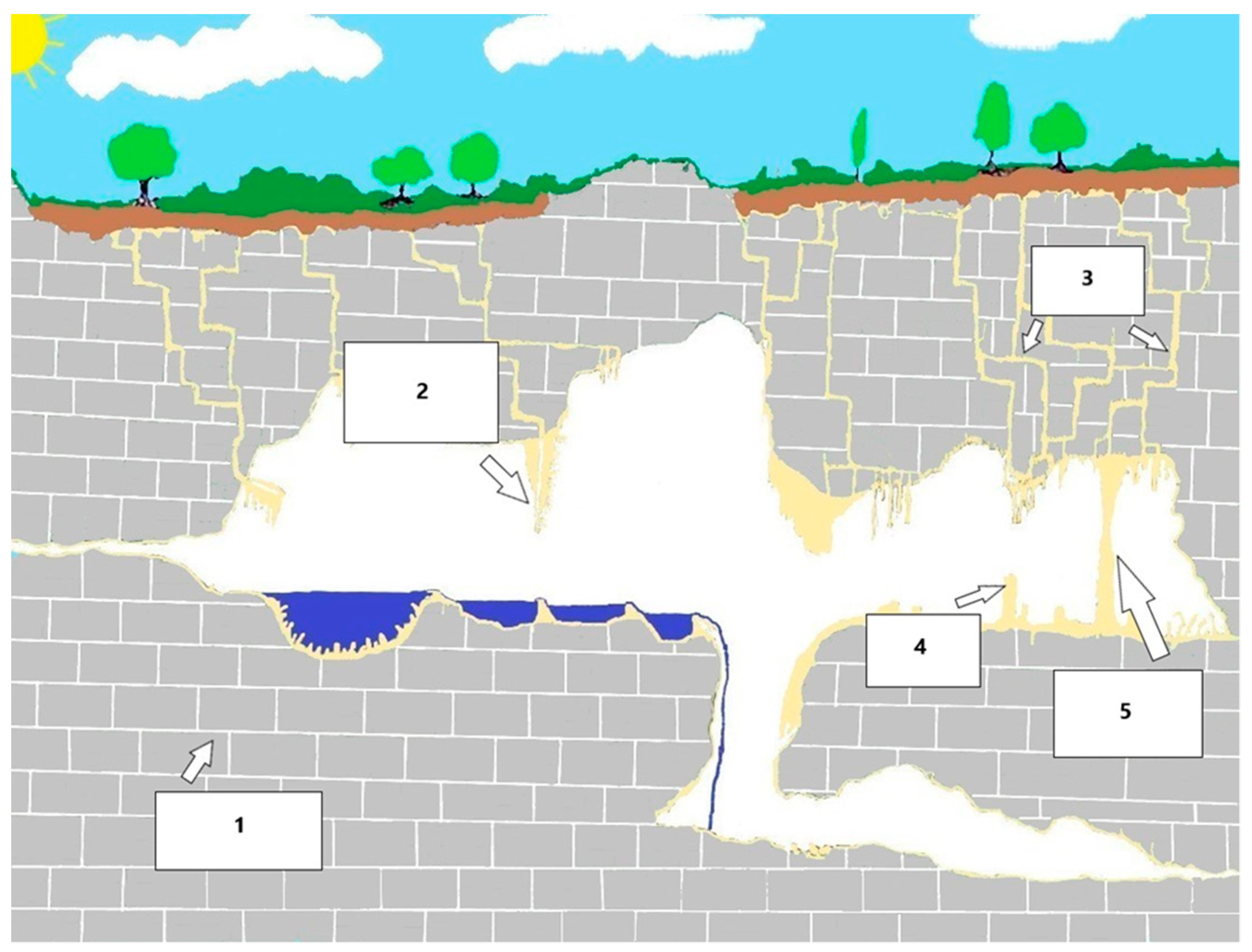
One of the central topics of the program is cave formation, visualized through a series of diagrams, such as in Figure 3. These diagrams outline the stages of cave development, beginning with water seeping through the soil and dissolving limestone to form cavities. Over time, these small cavities expand, ultimately forming large underground chambers. As this process continues, formations like stalactites and stalagmites begin to develop, illustrating the complexity and delicate nature of cave systems, which can take thousands to millions of years to form. This visual journey not only explains the stages of cave formation but also emphasizes the significance of specific geological conditions, such as the presence of limestone, and cultivates an appreciation for the fragility of these natural formations.
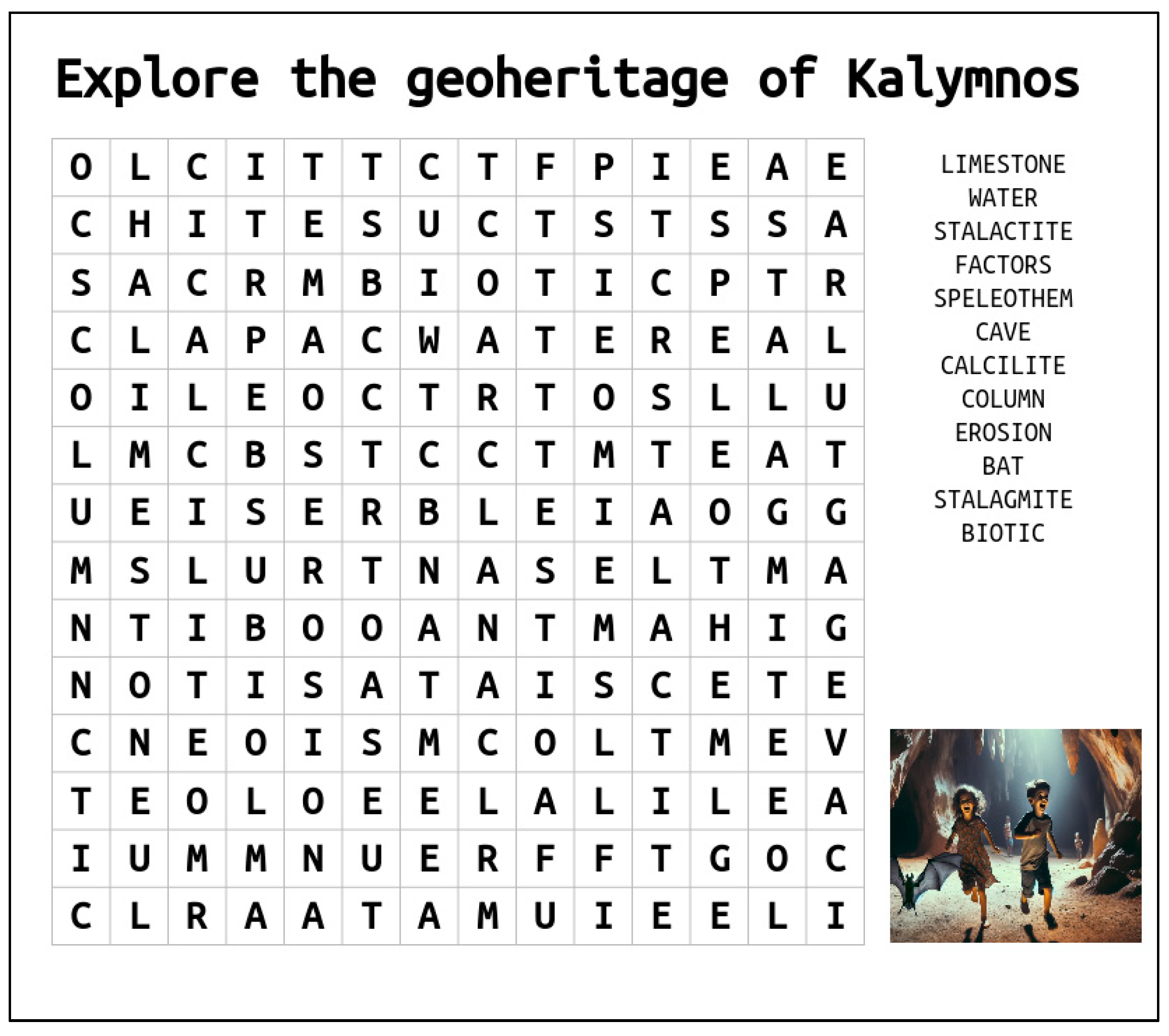
Upon returning to the classroom, participants complete various exercises to assess their understanding of the material covered. These include true/false and multiple-choice questions, as seen in Table 1 and Table 2, to evaluate their comprehension of cave formation and related geological concepts. Additionally, participants engage with interactive tools like a detailed diagram of a cave system (Figure 4) and a hidden word puzzle (Figure 5), which reinforces key terms in an enjoyable manner.
The program concludes with an evaluation rubric (Table 3), where participants reflect on their learning outcomes. The rubric assesses criteria such as understanding of geological concepts, heightened awareness of geoenvironmental protection, and the promotion of sustainable development. This feedback is crucial in measuring the program’s impact on participants’ knowledge and awareness, offering insights for future enhancements.

2.4. Justification of the Choice of Kalymnos and Nisyros for the Geoeducational Program on Caves

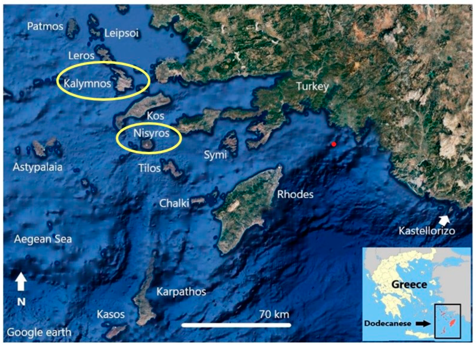
The islands of Nisyros and Kalymnos are located in the southeastern Aegean Sea and are part of the Dodecanese Island complex (Figure 6).
The island of Kalymnos was chosen for the implementation of our geoeducational program on caves because of its exceptional geological and geomorphological diversity. Kalymnos, located in the Dodecanese Island complex, is part of a region rich in geodiversity, which is affected by intense geotectonic activity at the convergence of the European and African lithospheric plates. The island is mainly composed of limestone, which earned it the nickname “limestone island”, and it is home to approximately 50 caves, many of which are still unexplored and offer unique educational opportunities [17].
Kalymnos’ rich geoheritage and spectacular landscape, including its caves, deep gorges, and mountains, make it an ideal location for geoeducation. These physical features provide a tangible context for students to learn geological concepts, processes, and the importance of geoheritage. In addition, the decrease in tourism on the island is an opportunity to revive interest through educational and geotourism initiatives. By implementing this program, we aim to enhance environmental awareness and respect for geo-heritage among students while contributing to the sustainable development of the local community through increased tourism.
The logic behind the implementation of the geoeducational program on the island of Nisyros, despite the absence of caves, lies in its unique geological importance as a volcanic island. Nisyros offers a unique educational opportunity to explore and understand volcanic processes, rock formations, and geothermal phenomena, which complement the study of the limestone caves at Kalymnos. With the inclusion of Nisyros, the program provides a broader geological perspective, exposing students to different geological environments in proximity. This diversity enriches the educational experience, promoting a deeper appreciation for the variety of geological features and processes that shape different landscapes [18].

3. Results

Regarding the participation rates of pupils and teachers in the pre- and post-test, it is noteworthy that 444 pupils participated out of a total of 672 (66.07%). Teachers showed a lower participation rate, as only 55 out of 94 in total (58.5%) participated. Therefore, the total sample that answered the questions was 499.

3.1. Results of the Pre-Test (Questionnaire A)

The pre-test included 25 closed-type questions designed to measure knowledge of basic geological concepts and geosites. The findings from the 499 participants are summarized below (as shown in Appendix B; Table A1).
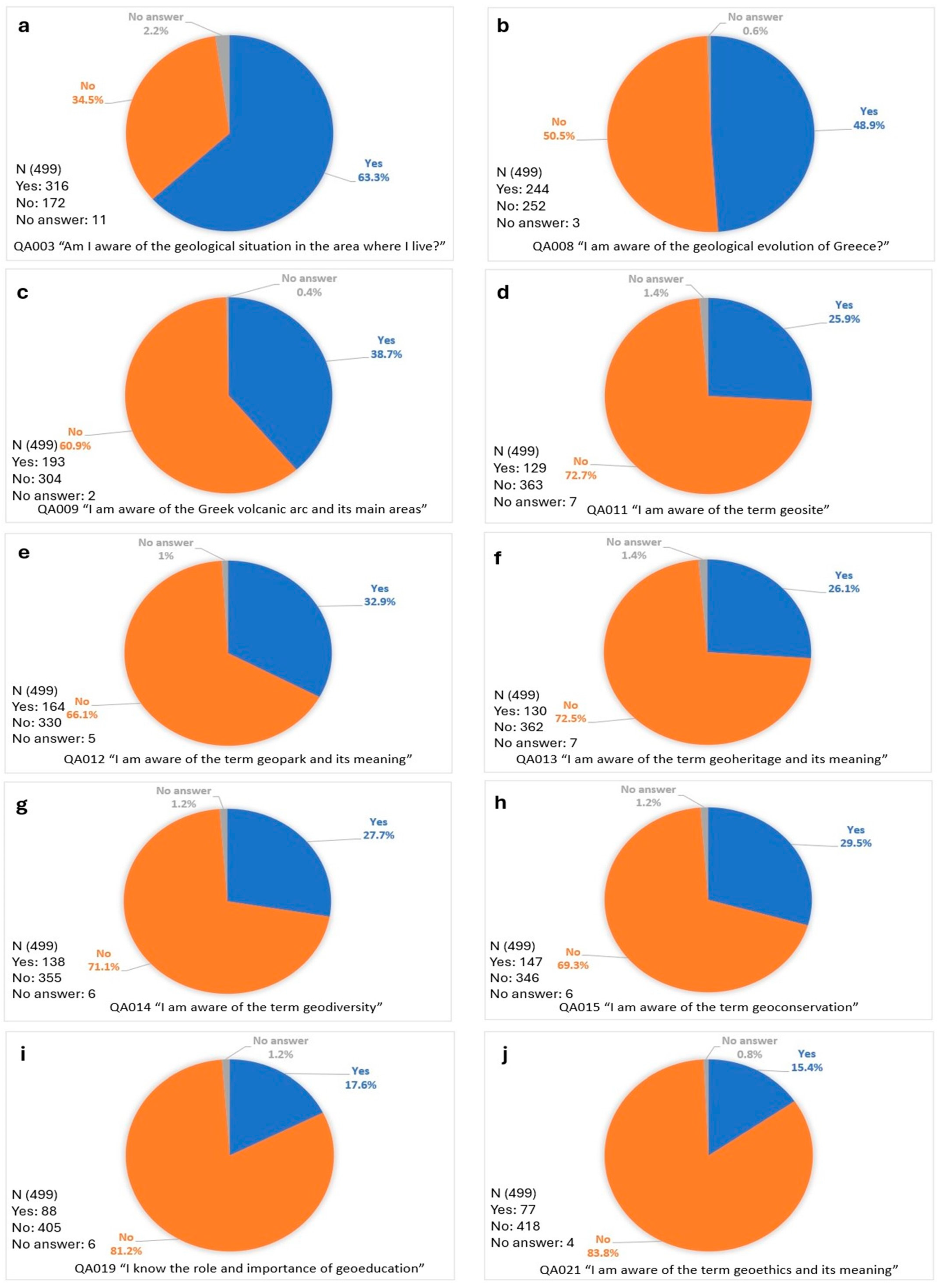
The pre-test studied participants’ awareness levels concerning geological concepts, including local geological conditions, the geological evolution of Greece, the Greek volcanic arc, and specialized terms, such as geosite, geopark, geoheritage, geodiversity, geoeducation, and geoethics. The findings indicate significant disparities in participants’ familiarity with these subjects, highlighting the need for enhanced educational frameworks to improve geological literacy and public understanding of geosciences (Figure 7).
Awareness of local geological conditions was relatively high, with 63.30% of participants expressing familiarity with the geological context of their area (Figure 7a). In contrast, knowledge of broader geological phenomena, such as the evolution of Greece, was equally limited, with 48.90% demonstrating awareness (Figure 7b). However, recognition of the Greek volcanic arc was substantially lower, with only 38.70% of participants aware of its main regions (Figure 7c). These results suggest a strong tendency toward localized geological awareness, accompanied by significant gaps in understanding broader regional or national geological contexts.
The study also revealed low levels of awareness concerning critical geological terms. Terms such as “geosite”, “geopark”, “geoheritage”, and “geodiversity” were recognized by less than one-third of participants, indicating limited exposure to the vocabulary of geoheritage (Figure 7d–h). Even lower awareness was observed for “geoeducation” and “geoethics”, with only 17.60% and 15.40% of respondents, respectively, acknowledging their importance (Figure 7i,j). This lack of familiarity underscores the challenges of conveying the societal and scientific significance of these concepts to a broader audience.
The findings underline the pressing need for targeted geoeducational programs aimed at bridging these knowledge gaps. By incorporating innovative interdisciplinary approaches and integrating geoscientific concepts into existing educational curricula, it is possible to foster a deeper understanding of geodiversity, geoheritage, and the ethical dimensions of geosciences. Such efforts are essential to cultivating a more informed public that appreciates the importance of geological resources in sustainable development and conservation efforts.

3.2. Results of the Post-Test (Questionnaire B)

The post-test included 25 questions, with the first two questions being the same as those of the pre-test. The post-test was conducted after the geoeducation program and aimed to assess whether there was a positive response and improved understanding of geoeducation and its conceptual framework. The findings from the 499 participants are as follows (as shown in Appendix B; Table A2):
In the post-test, perceptions and associations regarding geoeducation, geoheritage, geoconservation, geoethics, geosites, and geoparks among participants were studied. The findings reveal diverse interpretations of these concepts, emphasizing the multifaceted understanding of geological and environmental themes within the sample group.
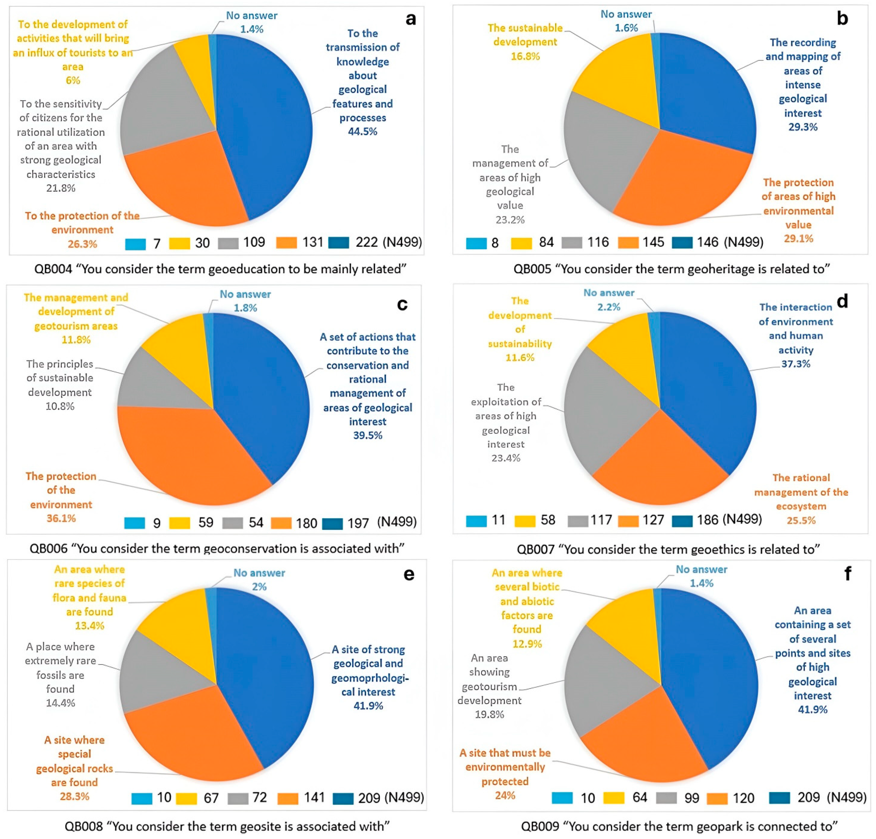
Regarding geoeducation, 44.50% of participants primarily associated it with the transmission of knowledge about geological features and processes (Figure 8a). Other significant associations included environmental protection (26.30%) and fostering sensitivity for the rational use of geologically significant areas (21.80%). Geoheritage was primarily linked to the recording and mapping of areas of geological interest (29.30%) and the protection of high environmental value areas (29.10%). Fewer respondents connected it to sustainable development (16.80%), reflecting a potential gap in integrating geoheritage with broader sustainability narratives (Figure 8b).
Geoconservation was most commonly understood as a set of actions for conserving and rationally managing geological areas (39.50%), followed by its association with environmental protection (36.10%). However, fewer participants linked it to sustainable development (10.80%) or geotourism management (11.80%) (Figure 8c). Geoethics was widely associated with the interaction between human activity and the environment (37.30%), followed by the rational management of ecosystems (25.50%). Notably, only 11.60% connected geoethics to sustainability, suggesting limited integration of ethical considerations into sustainability discourse among the respondents (Figure 8d).
Participants demonstrated a broad understanding of geosites and geoparks, with 41.90% identifying a geosite as a location of significant geological and geomorphological interest (Figure 8e). Similarly, 41.90% viewed a geopark as an area comprising multiple sites of high geological interest (Figure 8f). However, secondary associations, such as geotourism development and biotic–abiotic interactions, were less prevalent. These findings underscore the need for targeted educational strategies to deepen understanding of these concepts and their interconnected roles in promoting geosciences, environmental protection, and sustainable development.

4. Discussion

4.1. Insights into the Current State and Impact of Geoeducation in Greece

As mentioned above, the purpose of this research was to determine the current state of the educational community regarding issues related to geoeducation. Consequently, the pre-test was structured in such a way as to establish the level of knowledge on these topics through closed-type questions. In general, a lack of understanding of concepts and terms considered basic geological knowledge was found.
It is also important to note that the pupils showed a greater willingness to participate than teachers. Specifically, 66.07% of pupils participated, while only 58.50% of teachers did. This relatively low participation rate among teachers highlights a potential issue. It indicates a possible reluctance or lack of awareness of the importance of a geoeducational program and the concepts it addresses.
Regarding the answers of the pre-test, 34.50% of participants did not know the fundamental geological issues in their region. In addition, four out of ten participants had not visited areas of intense geological interest located in their place of residence. This indicates a lack of rational and collective utilization of such areas, which could benefit from appropriate promotion. Local bodies should engage in various promotional activities with the local community. Only in this way can sites with strong geological features become attractions for visitors, offering not only basic tourist services but also recreational opportunities.
In addition, the teaching of geology is mainly carried out by staff from other disciplines. More specifically, 50.10% of the participants stated that the course is not taught by a geologist. This is perhaps the most concerning finding of the study, as it has important implications for the transfer of knowledge about geoeducation and the promotion of geoethical values. Therefore, the Ministry of Education should ensure a higher percentage of geologists in school units nationwide, especially in areas of strong geological interest
More than 50% of the participants did not know the geological evolution of Greece or the Greek volcanic arc and its location. In addition, terms such as geoconservation, geopark, geosite, geodiversity, geoheritage, and geoethics were unknown to over 60% of the participants, while in some cases this percentage exceeded 70%. This lack of awareness demonstrates the need for a major revision of school textbooks related not only to the teaching of geology but also to the broader geosciences or environmental education.
After training the participants through the geoeducation program, it was found that both students and teachers seemed to understand the basic concepts related to geoeducation. In fact, the students showed interest through the many questions they asked during the presentation of the geoeducational program. The use of digital tools (such as computers, tablets, and video projectors) during the program played an important role in the learning process. These tools allowed participants to see and identify key geological features in real time, leading to a more interactive and engaging learning experience, which greatly helped in better understanding various geological terms. Thus, it is immediately apparent that geoeducation is an interdisciplinary field of study.
The participants’ answers in the post-test show a significant improvement in the understanding of the general topic. Most participants appeared to understand concepts such as geoconservation, geopark, geoheritage, geodiversity, and geoethics and how they relate to each other. They also provided insightful answers about the relationship between geoeducation, sustainable development, geotourism, and practices that benefit the local community. It is worth noting that question QB 018 in the post-test had the highest mean value (M * (N 499) = 4.0) of all responses. This suggests that geoeducation can contribute positively to the economic development of a region, based on the principles of sustainable development.

4.2. Proposal for the Integration of Geoeducation into the Greek Curriculum

Geoeducation, which focuses on geological heritage through holistic and interdisciplinary methods, is expected to significantly promote these values [25]. Therefore, geoscientists are encouraged to support geoeducation as a critical social value [26], aiming to transform students into aware and informed citizens with a strong sense of participation and rational stewardship. Despite its importance, geoenvironmental education has not yet been integrated into school curricula. Ideally, it should be a central element of both primary and secondary education in all subjects, with geoethics a fundamental element of every curriculum [27].
In this direction, innovative teaching methods can contribute positively to the promotion of geoeducation and its dimensions. Integrating geoeducation into school curricula through innovative teaching methods, such as STEAM, STEMAC, and HASS, can significantly enhance student engagement and promote deeper understanding of geological concepts [28,29,30,31]. The implementation of the geoeducational program in Kalymnos and Nisyros demonstrated several positive outcomes, particularly in enhancing students’ awareness of geoheritage and geodiversity while fostering their engagement with digital tools such as tablets and personal computers. These findings highlight the potential of interactive and interdisciplinary educational approaches to enrich understanding and stimulate interest in geosciences.
The integration of learning frameworks such as STEAM (Science, Technology, Engineering, Arts, and Mathematics), STEMAC (Science, Technology, Engineering, Mathematics, Agriculture, and Culture), and HASS (Humanities, Arts, and Social Sciences) could further amplify the program’s impact. These methodologies offer structured opportunities to develop critical thinking, creativity, and problem-solving skills, all of which were observed as beneficial outcomes of the program.
For instance, STEAM could enable students to incorporate artistic and design elements into scientific learning, such as creating digital geoheritage maps or artistic representations of local geodiversity. STEMAC, by integrating agricultural and cultural components, could encourage students to explore the interplay between agricultural practices, cultural history, and geodiversity on the islands. Similarly, HASS could facilitate an appreciation of the historical and societal relevance of geoheritage through activities such as research projects or narrative-based explorations of the volcanic history of Nisyros or the climbing culture of Kalymnos.
These frameworks build upon the program’s initial successes by offering broader and more diverse pathways for learning, thereby ensuring that the benefits of geoeducation are both sustained and expanded. Specific applications, such as the development of virtual tours for geoheritage sites or the analysis of geological features’ impacts on local culture, illustrate how these methodologies can directly contribute to educational goals centered on geoheritage and geodiversity.
For the aforementioned reasons, the promotion of geoeducation is extremely important for society, as through geoeducation activities, sustainable development will be more directly ensured, which is a cornerstone and goal for the well-being of all peoples, because of the negative environmental impacts observed. As shown in Figure 9, the pyramid symbolizes the foundational actions required for a progressive pathway toward achieving sustainability. Geoeducation, situated at the base of it, represents the essential activities that underpin and facilitate the following stages: recognition of geodiversity, geoconservation, geoheritage promotion, and geoethical awareness.
The structure is designed to highlight the logical and sequential interdependence of these actions. Each tier of the pyramid reflects a necessary step that builds upon the preceding one, ultimately culminating in sustainability at the apex. This metaphor illustrates that achieving sustainability requires first establishing a robust foundation through geoeducational initiatives. In addition, geoeducation can spread awareness of the geoethical value that a geosite bears witness to and the value of the geoheritage it reflects [32]. Thus, the preservation and protection of an area of intense geological interest can be more immediately ensured. Along with geoeducation, geotourism actions can be developed at the same time, which can lead to the upgrading of the standard of living of a society [33,34].
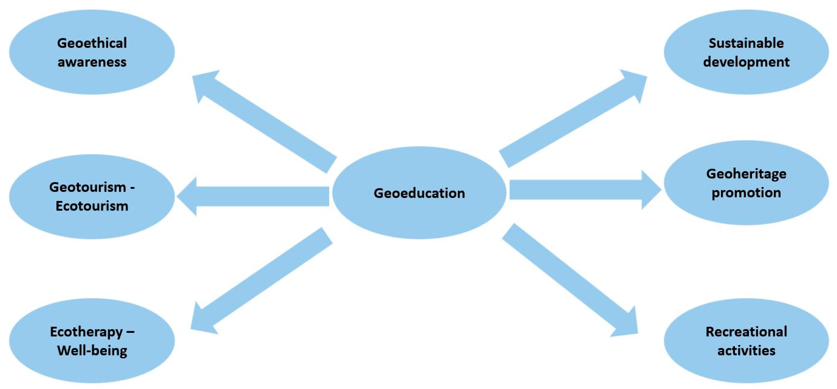
In addition to the above, research has shown that when an educational activity takes place in the environment, students reap many benefits. First, a more fruitful relationship with the environment develops. Also, their skills are strengthened and a sense of responsibility, awareness, conservation, protection of the geoenvironment, and ecological consciousness is cultivated [35,36]. In addition, engaging in such activities also benefits their mental health and promotes creativity, as students can comfortably engage in various individual (e.g., painting) or collective (e.g., theater) actions. The positive effects of ecotherapy are directly linked to the geopedagogical activity [37,38,39,40,41]. Therefore, it becomes clear that geoeducation plays a central role in education [42,43] and contributes significantly to various fields such as sustainable development, geoethical awareness, promotion of geoheritage value, geotourism–ecotourism, leisure activities, and ecotherapy or wellness (Figure 10).

5. Conclusions

This study highlights the critical need to incorporate geoeducation into the Greek school curriculum. By evaluating current knowledge levels among students and teachers, the research identifies significant gaps in geological understanding, stressing the urgency for curriculum reform. The proposed integration of geoeducation, supported by innovative teaching methods, like STEAM, STEMAC, and HASS, aims to make geosciences more accessible, engaging, and relevant. This approach not only enhances geological knowledge but also promotes environmental stewardship, geoethical awareness, and community development. The findings suggest that with proper implementation and teacher training, geoeducation can play a pivotal role in fostering a generation that is better equipped to address environmental and societal challenges, aligning with sustainable development goals.

Author Contributions

Conceptualization, G.Z. and H.D.; methodology, G.Z. and H.D.; formal analysis, G.Z.; investigation, G.Z.; resources, G.Z.; data curation, G.Z.; writing—original draft preparation, G.Z.; writing—review and editing, H.D.; supervision, H.D. All authors have read and agreed to the published version of the manuscript.

Funding

This research received no external funding.

Data Availability Statement

The data presented in this study are available upon request from the corresponding author.

Acknowledgments

The authors gratefully thank the journal editor and the three reviewers for their thorough consideration of this paper.

Conflicts of Interest

The authors declare no conflicts of interest.

Appendix A

Questionnaire A
001.
Educational status
001.1
I am pupil in a junior high school
001.2
I am teacher in a junior high school
002.
Gender
002.1
Female
002.2
Male
003.
Am I aware of the geological situation of the area in which I live?
Yes  No
004.
I have visited the areas with strong geological features in my place of residence:
Yes  No
005.
I know basic information about the wider geological feature of my area because I studied a book of:
005.1
Geology–Geography
005.2
History
005.3
Wider bibliographic sources
005.4
I do not know
006.
The course of Geology–Geography is taught by:
006.1
Geologist
006.2
Physicist
006.3
Chemist
006.4
Biologist
006.5
Other specialty: __________
007.
Participation in programs:
007.1
I have participated in a school geoenvironmental educational program
007.2
I have participated in other types of educational programs
007.3
I have participated in an extracurricular environmental program
007.4
I have not participated in any environmental or educational program
008.
I am aware of the geological evolution of Greece:
Yes  No
009.
I am aware of Greek volcanic arc and its main areas:
Yes  No
010.
Why does Greece have strong seismicity?
010.1
Because of its volcanoes
010.2
Due to climatic conditions
010.3
Due to the point of convergence of lithospheric plates
010.4
Because of its rocks
011.
I am aware of the term geosite:
Yes  No
012.
I am aware of the term geopark and its meaning:
Yes  No
013.
I am aware of the term geoheritage and its meaning:
Yes  No
014.
I am aware of the term geodiversity:
Yes  No
015.
I am aware of the term geoconservation:
Yes  No
016.
I know if Greece has geoparks:
Yes  No
017.
I am aware of the term sustainable development and its benefits:
Yes  No
018.
Have you ever heard of geoeducation?
Yes  No
If so, please state: __________
019.
I know the role and importance of geoeducation:
Yes  No
020.
I am aware of various geoeducational activities:
Yes  No
If so, please list some: __________
021.
I am aware of the term geoethics and its meaning:
Yes  No
022.
I believe that geoeducation can contribute positively to a society:
Yes  No
If so, please state how: __________
023.
I am engaged in geoeducational activities:
Yes  No
024.
I know how many geoparks Greece has and where they are located:
Yes  No
025.
I think that geoeducation is also connected with cultural or archaeological values:
Yes  No
Questionnaire B
001.
Educational status
001.1
I am pupil in a junior high school
001.2
I am teacher in a junior high school
002.
Gender
002.1
Female
002.2
Male
003.
How do you think geoeducation will be developed and spread?
003.1
Through intramural activities and similar geoeducational programs
003.2
Through a document that will contain its meaning and dimensions
003.3
Through extracurricular geoenvironmental activities
003.4
Through initiatives of the municipality or the local community
004.
You consider the term geoeducation to be mainly related:
004.1
To the transmission of knowledge about geological features and processes
004.2
To the protection of the environment
004.3
To the sensitivity of citizens for the rational utilization of an area with strong geological characteristics
004.4
To the development of activities that will bring an influx of tourists to an area
005.
You consider the term geoheritage is related to:
005.1
The recording and mapping of areas of intense geological interest
005.2
The protection of areas of high environmental value
005.3
The management of areas of high geological value
005.4
The sustainable development
006.
You consider the term geoconservation is associated with:
006.1
A set of actions that contribute to the conservation and rational management of areas of geological interest
006.2
The protection of the environment
006.3
The principles of sustainable development
006.4
The management and development of geotourism areas
007.
You consider the term geoethics is related to:
007.1
The interaction of environment and human activity
007.2
The rational management of the ecosystem
007.3
The exploitation of areas of high geological interest
007.4
The development of sustainability
008.
You consider the term geosite is associated with:
008.1
A site of strong geological and geomorphological interest
008.2
A site where special geological rocks are found
008.3
A place where extremely rare fossils are found
008.4
An area where rare species of flora and fauna are found
009.
You consider the term geopark is connected to:
009.1
An area containing a set of several points and sites of high geological interest
009.2
A site that must be environmentally protected
009.3
An area showing geotourism development
009.4
An area where several biotic and abiotic factors are found
010.
In your opinion, what is the most important sector that geoeducation should develop (choose more than one answer):
010.1
Geoscientific knowledge
010.2
Awareness regarding natural disasters
010.3
Rational use of mineral wealth
010.4
Awareness of sustainable development and its applications
010.5
Awareness of geoheritage
010.6
Awareness of geoconservation and environmental protection
010.7
Awareness of geoethics and its beneficial dimensions
011.
Geotourism is a form of tourism:
011.1
With the main object of geoeducational activities and visiting areas with high geological value
011.2
With alternative activities (alternative tourism)
011.3
For the development of tourism infrastructure
011.4
Series of activities for the protection of the environment
Please indicate (√) the Extent to Which You Agree with the Following Suggestions.
1: Strongly Disagree, 2: Disagree, 3: Neither Agree nor Disagree, 4: Agree,
5: Strongly Agree
12345
012. Do you think that the educational system contributes to the promotion of geoeducation?
013. Do you think there are geoeducational programs that will promote and highlight geoheritage at a national level?
014. Would you like to participate in geoeducational activities or programs?
015. Do you think that geoeducation will contribute to sustainable development?
016. Would you be interested in learning more about geoeducation?
017. Do you consider that geoeducation beyond geological values,
transmits additional historical, archaeological values, etc.?
018. Do you think that geoeducation contributes to the economic
development of an area?
019. Do you think that geoeducation contributes to the
citizens’ awareness for the preservation and protection of the environment?
020. Do you think that geoeducational activities can
change the standard of living of the citizens of a local community?
021. Do you think that geoeducational activities will contribute to
geotourism development of an area?
022. Do you think that awareness of geoheritage value will contribute to the preservation and protection of the environment?
023. Do you think that awareness of geoheritage will contribute to
the transmission of the principles of sustainable development?
024. Do you think that the transmission of the geoheritage value will contribute to the awareness of the citizens for the protection and utilization of the geological areas that show strong interest?
025. Do you think that geoeducation promotes various recreational activities?

Appendix B

Table A1. Summarized data per question in Questionnaire A.
QuestionSummarized Data
001. Educational statusPupils: 443 (88.80%)Teachers: 55 (11.07%)No answer: 1 (0.20%)
002. GenderMale: 241 (48.30%)Female: 257 (51.50%)No answer: 1 (0.20%)
003. Am I aware of the geological situation of the area in which I live?Yes499 (N): 316 (63.30%)No499 (N): 172 (34.50%)No answer499 (N): 11 (2.20%)
004. I have visited the areas with strong geological features in my place of residence:Yes499 (N): 290 (58.10%)No499 (N): 204 (40.90%)No answer499 (N): 5 (1.00%)
005. I know basic information about the wider geological feature of my area because I studied a book on:
005.1. Geology–GeographyYes499 (N): 171Yes499 (%): 34.30
005.2. HistoryYes499 (N): 62Yes499 (%): 12.40
005.3. Wider bibliographic sourcesYes499 (N): 54Yes499 (%): 10.80
005.4. I do not knowYes499 (N): 205Yes499 (%): 41.90
No answerYes499 (N): 3Yes499 (%): 0.60
006. The course of Geology–Geography is taught by:
006.1. GeologistYes499 (N): 249Yes499 (%): 49.90
006.2. PhysicistYes499 (N): 76Yes499 (%): 15.20
006.3. ChemistYes499 (N): 34Yes499 (%): 6.80
006.4. ΒiologistYes499 ( N): 92Yes499 (%): 18.40
006.5. Other specialty: __________Yes499 (N): 45Yes499 (%): 9.00
No answerYes499 (N): 3Yes499 (%): 0.60
007. Participation in programs:
007.1. I have participated in a school geoenvironmental educational programYes499 (N): 82Yes499 (%): 16.40
007.2. I have participated in other types of educational programsYes499 (N): 115Yes499 (%): 23.00
007.3. I have participated in an extracurricular environmental programYes499 (N): 62Yes499 (%): 12.40
007.4. I have not participated in any environmental or educational programYes499 (N): 238Yes499 (%): 47.80
No answerYes499 (N): 2Yes499 (%): 0.40
008. I am aware of the geological evolution of Greece:Yes499 (N): 244 (48.90%)No499 (N): 252 (50.50%)No answer499 (N): 3 (0.60%)
009. I am aware of Greek volcanic arc and its main areas: Yes499 (N): 193 (38.70%)No499 (N): 304 (60.90%)No answer499 (N): 2 (0.40%)
010. Why does Greece have strong seismicity?
010.1. Because of its volcanoesYes499 (N): 53Yes499 (%): 10.60
010.2. Due to climatic conditionsYes499 (N): 53Yes499 (%): 10.60
010.3 Due to the point of convergence of lithospheric platesYes499 (N): 339Yes499 (%): 67.90
010.4 Because of its rocksYes499 (N): 48Yes499 (%): 9.70
No answerYes499 (N): 6Yes499 (%): 1.20
011. I am aware of the term geosite:Yes499 (N): 129 (25.90%)No499 (N): 363 (72.70%)No answer499 (N): 7 (1.40%)
012. I am aware of the term geopark and its meaning:Yes499 (N): 164 (32.90%)No499 (N): 330 (66.10%)No answer499 (N): 5 (1.00%)
013. I am aware of the term geoheritage and its meaningYes499 (N): 130 (26.10%)No499 (N): 362 (72.50%)No answer499 (N): 7 (1.40%)
014. I am aware of the term geodiversityYes499 (N): 138 (27.70%)No499 (N): 355 (71.10%)No answer499 (N): 6 (1.20%)
015. I am aware of the term geoconservationYes499 (N): 147 (29.50%)No499 (N): 346 (69.30%)No answer499 (N): 6 (1.20%)
016. I know if Greece has geoparksYes499 (N): 225 (45.10%)No499 (N): 268 (53.70%)No answer499 (N): 6 (1.20%)
017. I am aware of the term sustainable development and its benefits:Yes499 (N): 221 (44.30%)No499 (N): 275 (55.10%)No answer499 (N): 3 (0.60%)
018. Have you ever heard of geoeducation?Yes499 (N): 82 (16.40%)No499 (N): 415 (83.20%)No answer499 (N): 2 (0.40%)
019. I know the role and importance of geoeducationYes499 (N): 88 (17.60%)No499 (N): 405 (81.20%)No answer499 (N): 6 (1.20%)
020. I am aware of various geoeducational activitiesYes499 (N): 64 (12.80%)No499 (N): 430 (86.20%)No answer499 (N): 5 (1.00%)
021. I am aware of the term geoethics and its meaningYes499 (N): 77 (15.40%)No499 (N): 418 (83.80%)No answer499 (N): 4 (0.80%)
022. I believe that geoeducation can contribute positively to a societyYes499 (N): 211 (42.30%)No499 (N): 276 (55.30%)No answer499 (N): 12 (2.40%)
023. I am engaged in geoeducational activitiesYes499 (N): 102 (20.40%)No499 (N): 396 (79.40%)No answer499 (N): 1 (0.20%)
024. I know how many geoparks Greece has and where they are locatedYes499 (N): 80 (16.00%)No499 (N): 417 (83.60%)No answer499 (N): 2. (0.40%)
025. I think that geoeducation is also connected with cultural or archaeological valuesYes499 (N): 306 (61.30%)No499 (N): 190 (38.10%)No answer499 (N): 3 (0.60%)
Table A2. Summarized data per question of questionnaire B.
QuestionSummarized Data
001. Educational statusPupils: 443 (88.80%)Teachers: 55 (11.07%)No answer: 1 (0.20%)
002. GenderMale: 241 (48.30%)Female: 257 (51.50%)No answer: 1 (0.20%)
003. How do you think geoeducation will be developed and spread?
003.1. Through intramural activities and similar geoeducational programsYes499 (N): 259Yes499 (%): 51.90
003.2. Through a document that will contain its meaning and dimensionsYes499(N): 48Yes499 (%): 9.60
003.3. Through extracurricular geoenvironmental activitiesYes499 (N): 91Yes499(%): 18.20
003.4. Through initiatives of the municipality or the local communityYes499 (N): 92Yes499 (%): 18.50
No answerYes499 (N): 9Yes499 (%): 1.80
004. You consider the term geoeducation to be mainly related:
004.1. To the transmission of knowledge about geological features and processesYes499 (N): 222Yes499 (%): 44.50
004.2. To the protection of the environmentYes499 (N): 131Yes499 (%): 26.30
004.3. To the sensitivity of citizens for the rational utilization of an area with strong geological characteristicsYes499 (N): 109Yes499 (%): 21.80
004.4. To the development of activities that will bring an influx of tourists to an areaYes499 (N): 30Yes499 (%): 6.00
No answerYes499 (N): 7Yes499 (%): 1.40
005. You consider the term geoheritage is related to:
005.1. The recording and mapping of areas of intense geological interestYes499 (N): 146Yes499 (%): 29.30
005.2. The protection of areas of high environmental valueYes499 (N): 145Yes499 (%): 29.10
005.3. The management of areas of high geological valueYes499 (N): 116Yes499 (%): 23.20
005.4. The sustainable developmentYes499 (N): 84Yes499 (%): 16.80
No answerYes499 (N): 8Yes499 (%): 1.60
006. You consider the term geoconservation is associated with:
006.1. A set of actions that contribute to the conservation and rational management of areas of geological interestYes499 (N): 197Yes499 (%): 39.50
006.2. The protection of the environmentYes499 (N): 180Yes499 (%): 36.10
006.3. The principles of sustainable developmentYes499 (N): 54Yes499 (%): 10.80
006.4. The management and development of geotourism areasYes499 (N): 59Yes499 (%): 11.80
No answerYes499 (N): 9Yes499 (%): 1.80
007. You consider the term geoethics is related to:
007.1. The interaction of environment and human activityYes499 (N): 186Yes499 (%): 37.30
007.2. The rational management of the ecosystemYes499 (N): 127Yes499 (%): 25.50
007.3. The exploitation of areas of high geological interestYes499 (N): 117Yes499 (%): 23.40
007.4. The development of sustainabilityYes499 (N): 58Yes499 (%): 11.60
No answerYes499 (N): 11Yes499 (%): 2.20
008. You consider the term geosite is associated with:
008.1. A site of strong geological and geomorphological interestYes499 (N): 209Yes499 (%): 41.90
008.2. A site where special geological rocks are foundYes499 (N): 141Yes499 (%): 28.30
008.3. A place where extremely rare fossils are foundYes499 (N): 72Yes499 (%): 14.40
008.4. An area where rare species of flora and fauna are foundYes499 (N): 67Yes499 (%): 13.40
No answerYes499 (N): 10Yes499 (%): 2.00
009. You consider the term geopark is connected to:
009.1. An area containing a set of several points and sites of high geological interestYes499 (N): 209Yes499 (%): 41.90
009.2. A site that must be environmentally protectedYes499 (N): 120Yes499 (%): 24.00
009.3. An area showing geotourism developmentYes499 (N): 99Yes499 (%): 19.80
009.4. An area where several biotic and abiotic factors are foundYes499 (N): 64Yes499 (%): 12.90
No answerYes499 (N): 7Yes499 (%): 1.40
010. In your opinion, what is the most important sector that geoeducation should develop (choose more than one answer):
010.1. Geoscientific knowledgeYes499 (N): 255Yes499 (%): 51.10
010.2. Awareness regarding natural disastersYes499 (N): 170Yes499 (%): 34.06
010.3. Rational use of mineral wealthYes499 (N): 128Yes499 (%): 25.65
010.4. Awareness of sustainable development and its applicationsYes499 (N): 96Yes499 (%): 19.23
010.5. Awareness of geoheritageYes499 (N): 206Yes499 (%): 41.28
010.6. Awareness of geoconservation and environmental protectionYes499 (N): 231Yes499 (%): 46.29
010.7. Awareness of geoethics and its beneficial dimensions Yes499 (N): 116Yes499 (%): 23.24
No answerYes499 (N): 7Yes499 (%): 1.40
011. Geotourism is a form of tourism:
011.1. With the main object of geoeducational activities and visiting areas with high geological valueYes499 (N): 233Yes499 (%): 46.90
011.2. With alternative activities (alternative tourism)Yes499 (N): 130Yes499 (%): 26.10
011.3. For the development of tourism infrastructureYes499 (N): 69Yes499 (%): 13.80
011.4. Series of activities for the protection of the environmentYes499 (N): 55Yes499 (%): 12.00
No answerYes499 (N): 7Yes499 (%): 1.40
012. Do you think that the educational system contributes to the promotion of geoeducation?M * (N499) = 2.1
013. Do you think there are geoeducational programs that will promote and highlight geoheritage at a national level?M * (N499) = 3.7
014. Would you like to participate in geoeducational activities or programs?M * (N499) = 3.5
015. Do you think that geoeducation will contribute to sustainable development?M * (N499) = 3.6
016. Would you be interested in learning more about geoeducation?M * (N499) = 3.6
017. Do you consider that geoeducation beyond geological values, transmits additional historical, archaeological values, etc.?M * (N499) = 3.5
018. Do you think that geoeducation contributes to the economic development of an area?M * (N499) = 4.0
019. Do you think that geoeducation contributes to the citizens’ awareness for the preservation and protection of the environment?M * (N499) = 3.6
020. Do you think that geoeducational activities can change the standard of living of the citizens of a local community?M * (N499) = 3.4
021. Do you think that geoeducational activities will contribute to geotourism development of an area?M * (N499) = 3.6
022. Do you think that awareness of geoheritage value will contribute to the preservation and protection of the environment?M * (N499) = 3.5
023. Do you think that awareness of geoheritage will contribute to the transmission of the principles of sustainable development?M * (N499) = 3.9
024. Do you think that the transmission of the geoheritage value will contribute to the awareness of the citizens for the protection and utilization of the geological areas that show strong interest?M * (N499) = 3.5
025. Do you think that geoeducation promotes various recreational activities?M * (N499) = 3.6
* Mean value on a 1 to 5 Likert scale.

References

  1. Brilha, J.B.R.; Reynard, E. Geoheritage and geoconservation: The challenges. In Geoheritage; Reynard, E., Brihla, J., Eds.; Elsevier: Amsterdam, The Netherlands, 2018; pp. 431–438. [Google Scholar] [CrossRef]
  2. Zafeiropoulos, G.; Drinia, H.; Antonarakou, A.; Zouros, N. From geoheritage to geoeducation, geoethics and geotourism: A critical evaluation of the Greek region. Geosciences 2021, 11, 381. [Google Scholar] [CrossRef]
  3. Martini, G. (Ed.) Actes du premier symposium international sur la protection au patrimonie geologique. In Memoires de la Societe 656 Geologique de France, Proceedings of the First Symposium on Earth Heritage Conservation, 11–16 June 1991; Numero Special 165; Société géologique de France: Digne, France, 1993; 276p. [Google Scholar]
  4. Zouros, N. The European Geoparks Network. Episodes 2004, 27, 165–171. [Google Scholar] [CrossRef]
  5. Zouros, N.; Valiakos, I. Geoparks Management and Assessment. Bull. Geol. Soc. Greece 2017, 43, 965–977. [Google Scholar] [CrossRef]
  6. Herrera-Franco, G.; Montalván-Burbano, N.; Carrión-Mero, P.; Apolo-Masache, B.; Jaya-Montalvo, M. Research trends in geotourism: A bibliometric analysis using the scopus database. Geosciences 2020, 10, 379. [Google Scholar] [CrossRef]
  7. Ólafsdóttir, R.; Tverijonaite, E. Geotourism: A systematic literature review. Geosciences 2018, 8, 234. [Google Scholar] [CrossRef]
  8. Rokka, A. Geology in primary education; Potential and perspectives. Bull. Geol. Soc. Greece 2018, 34, 819–823. [Google Scholar] [CrossRef]
  9. Meléndez, G.; Fermeli, G.; Koutsouveli, A. Analyzing Geology textbooks for secondary school curricula in Greece and 775 Spain: Educational use of geological heritage. Bull. Geol. Soc. Greece 2007, 40, 1819–1832. [Google Scholar] [CrossRef]
  10. Trikolas, K.; Ladas, I. The necessity of teaching earth sciences in secondary education. In Proceedings of the 3rd International 777 GEOschools Conference, Teaching Geosciences in Europe from Primary to Secondary School, Athens, Greece, 28–29 September 2013; pp. 73–76. [Google Scholar]
  11. Fermeli, G.; Meléndez, G.; Calonge, A.; Dermitzakis, M.; Steininger, F.; Koutsouveli, A.; Neto de Carvalho, C.; Rodrigues, J.; D’Arpa, C.; Di Patti, C. GEOschools: Innovative teaching of geosciences in secondary schools and raising awareness on 781 geoheritage in the society. In Avances y Retos en la Conservación del 782 Patrimonio Geológico en España; Fernández-Martínez, E., y Castaño de Luis, R., Eds.; Actas de la IX Reunión Nacional de la Comisión de Patrimonio Geológico (Sociedad 783 Geológica de España); Universidad de León: León, Spain, 2011; pp. 120–124. ISBN 978-84-9773-578-0. [Google Scholar]
  12. Georgousis, E.; Savelides, S.; Mosios, S.; Holokolos, M.-V.; Drinia, H. The Need for Geoethical Awareness: The Importance of 785 Geoenvironmental Education in Geoheritage Understanding in the Case of Meteora Geomorphes, Greece. Sustainability 2021, 13, 6626. [Google Scholar] [CrossRef]
  13. Creswell, J.C.; Clark, V.P. Designing and Conducting Mixed Methods Research, 3rd ed.; Sage Publications: Thousand Oaks, CA, USA, 2018. [Google Scholar]
  14. Saraswati, P.; Devi, A. Mixed Methods-Research Methodology an Overview. Mathews J. Nurs. Health Care 2023, 5, 1–3. [Google Scholar] [CrossRef]
  15. Winlow, H.; Simm, D.; Marvell, A.; Schaaf, R. Using focus group research to support teaching and learning. In Pedagogic Research in Geography Higher Education; Routledge: London, UK, 2017; pp. 112–123. [Google Scholar]
  16. Campbell, S.; Greenwood, M.; Prior, S.; Shearer, T.; Walkem, K.; Young, S.; Bywaters, D.; Walker, K. Purposive sampling: Complex or simple? Research case examples. J. Res. Nurs. 2020, 25, 652–661. [Google Scholar] [CrossRef] [PubMed]
  17. Zafeiropoulos, G.; Drinia, H. Kalymnos Island, SE Aegean Sea: From Fishing Sponges and Rock Climbing to Geotourism Perspective. Heritage 2021, 4, 3126–3146. [Google Scholar] [CrossRef]
  18. Zafeiropoulos, G.; Drinia, H. Comparative Analysis of Two Assessment Methods for the Geoeducational Values of Geosites: A Case Study from the Volcanic Island of Nisyros, SE Aegean Sea, Greece. Geosciences 2022, 12, 82. [Google Scholar] [CrossRef]
  19. Mann, K.; MacLeod, A. Constructivism: Learning Theories and Approaches to Research. In Researching Medical Education; Cleland, J., Durning, S.J., Eds.; John Wiley & Sons, Ltd.: Hoboken, NJ, USA, 2015; pp. 49–66. [Google Scholar] [CrossRef]
  20. Geitz, G.; Donker, A.; Parpala, A. Studying in an Innovative Teaching–Learning Environment: Design-Based Education at a University of Applied Sciences. Learn. Environ. Res. 2024, 27, 17–35. [Google Scholar] [CrossRef]
  21. Salinas-Navarro, D.E.; Vilalta-Perdomo, E.; Michel-Villarreal, R.; Montesinos, L. Using Generative Artificial Intelligence Tools to Explain and Enhance Experiential Learning for Authentic Assessment. Educ. Sci. 2024, 14, 83. [Google Scholar] [CrossRef]
  22. Siddiq, F.; Olofsson, A.D.; Lindberg, J.O.; Tomczyk, L. What Will Be the New Normal? Digital Competence and 21st-Century Skills: Critical and Emergent Issues in Education. Educ. Inf. Technol. 2024, 29, 7697–7705. [Google Scholar] [CrossRef]
  23. Argyilan, E.; Huysken, K.; Votaw, R. Deconstructing a Geology Field Trip to Reconstruct Around a Pedagogical Framework: A Case Study on the Integration of Cognitive Learning Theories and Learning Progressions. J. Sch. Teach. Learn. 2024, 24, 58–75. [Google Scholar] [CrossRef]
  24. Boyd, P.; Hill, J. Working with Rubrics. In Academic Standards in Higher Education: Critical Perspectives and Practical Strategies; Taylor & Francis: Abingdon, UK, 2024. [Google Scholar]
  25. Maran, A. Geoconservation in Serbia-State of play and future perspectives. Eur. Geol. 2012, 34, 1–72. [Google Scholar]
  26. Peppoloni, S.; Di Capua, G. Geoethics: Ethical, Social, and Cultural Values in Geosciences Research, Practice, and Education. In Geoscience for the Public Good and Global Development: Toward a Sustainable Future, Geological Society of America, Special Papers; Greg, W., Jeff, G., Eds.; Geological Society of America: Boulder, CO, USA, 2016; pp. 17–21. [Google Scholar]
  27. Promduangsri, P.; Crookall, D. Geoethics education: From theory to practice—A case study. In Proceedings of the EGU General Assembly 2020, Online, 4–8 May 2020. [Google Scholar] [CrossRef]
  28. Gates, A.E. Benefits of a STEAM collaboration in Newark, New Jersey: Volcano simulation through a glass-making experience. J. Geosci. Educ. 2017, 65, 4–11. [Google Scholar] [CrossRef]
  29. Liritzis, I.; Mainzer, K.; Lavicza, Z.; Fenyvesi, K.; Dinescu, V.; Orlandi, S.; Yu, H.; Teodorescou-Ciocanea, L.; Elias, M.I.; Cosmopoulos, M.; et al. EASA Expert Group: Science, Technology, Engineering, Mathematics in Arts and Culture (STEMAC). Proc. Eur. Acad. Sci. Arts 2024, 3, 27. [Google Scholar] [CrossRef]
  30. Georgousis, E.; Savelides, S.; Drinia, H. Interdisciplinary Approach Research of STEM&HASS Educational Objects in Confronting Complex Environmental Problems. In Proceedings of the 8th Conference on Environmental Education for Sustainability in the Age of Climate Change, Patra, Greece, 11–13 September 2020. [Google Scholar]
  31. Mereli, A.; Niki, E.; Psycharis, S.; Drinia, H.; Antonarakou, A.; Mereli, M.; Maria, T. Education of students from Greek schools regarding natural disasters through STEAM. Eur. J. Math. Sci. Technol. Educ. 2023, 19, em2314. [Google Scholar] [CrossRef] [PubMed]
  32. Zafeiropoulos, G.; Drinia, H. A new quantitative assessment method for the geoeducational potential of the geodiversity. In Proceedings of the EGU General Assembly Conference Abstracts, Vienna, Austria, 23–28 May 2023; p. EGU23-8907. [Google Scholar] [CrossRef]
  33. Zafeiropoulos, G.; Drinia, H. GEOAM: A Holistic Assessment Tool for Unveiling the Geoeducational Potential of Geosites. Geosciences 2023, 13, 210. [Google Scholar] [CrossRef]
  34. Zafeiropoulos, G.; Drinia, H. Effectiveness of the Geoeducational Assessment Method (GEOAM) in Unveiling Geoeducational Potential: A Case Study of Samos. Geosciences 2023, 13, 336. [Google Scholar] [CrossRef]
  35. Koupatsiaris, A.A.; Drinia, H. Expanding Geoethics: Interrelations with Geoenvironmental Education and Sense of Place. Sustainability 2024, 16, 1819. [Google Scholar] [CrossRef]
  36. Georgousis, E.; Savelidi, M.; Savelides, S.; Mosios, S.; Holokolos, M.-V.; Drinia, H. How Greek Students Perceive Concepts Related to Geoenvironment: A Semiotics Content Analysis. Geosciences 2022, 12, 172. [Google Scholar] [CrossRef]
  37. Song, Y.I.K. Exploring connections between environmental education and ecological public art. Child. Educ. 2008, 85, 13–19. [Google Scholar] [CrossRef]
  38. Asah, S.T.; Bengston, D.N.; Westphal, L.M.; Gowan, C.H. Mechanisms of children’s exposure to nature: Predicting adulthood environmental citizenship and commitment to nature-based activities. Environ. Behav. 2018, 50, 807–836. [Google Scholar] [CrossRef]
  39. Chawla, L. Benefits of nature contact for children. J. Plan. Lit. 2015, 30, 433–452. [Google Scholar] [CrossRef]
  40. Gill, T. The benefits of children’s engagement with nature: A systematic literature review. Child. Youth Environ. 2014, 24, 10–34. [Google Scholar] [CrossRef]
  41. Miranda Orama, T.J. Art and Eco Therapies: Benefits to Motor Development of Preschool-Age Children in the Screen Era. Master’s Thesis, Lesley University, Cambridge, MA, USA, 2022. [Google Scholar]
  42. Kondyli, C.; Psychogiou, M.; Drinia, H. The Museums of Geology and Paleontology as Geoeducational Learning Environments for Raising Climate Change Awareness. Sustainability 2024, 16, 4481. [Google Scholar] [CrossRef]
  43. Fanioudaki, E.; Drinia, H.; Fassoulas, C. Geocultural Interactions in Minoan Crete: An Environmental Education Perspective through Drama Techniques. Sustainability 2024, 16, 907. [Google Scholar] [CrossRef]
Figure 1. Flow chart defining the basic phases of the research.
Geosciences 14 00348 g001
Figure 2. Flow chart of the geoeducational program.
Geosciences 14 00348 g002
Figure 3. Arrange images in order from 1 to 4 showing cave formation.
Geosciences 14 00348 g003
Figure 4. Fill in the blanks with the appropriate geological terms.
Geosciences 14 00348 g004
Figure 5. Find the hidden words related to geological concepts.
Geosciences 14 00348 g005
Figure 6. Satellite photo of the Dodecanese Island complex, SE Greece; inlet: sketch map of Greece showing the location of Dodecanese Island complex.
Geosciences 14 00348 g006
Figure 7. Pie charts summarizing the awareness of 499 participants (N = 499) on various terms and concepts related to geoeducation. The key findings include that 63.3% of participants were aware of the local geological situation, but awareness of other geoscience concepts, such as geological evolution, geosites, geoheritage, and geoeducation, was significantly lower, indicating a general lack of knowledge in these areas. Explanation of subfigures (aj) in the text.
Geosciences 14 00348 g007
Figure 8. Pie charts illustrating the understanding of geoeducation and related terms among the 499 participants (N = 499). The majority (44.5%) associate geoeducation with knowledge of geological features, while 26.3% associate it with environmental protection. Responses to geoheritage, geoconservation, geoethics, geosites, and geoparks indicate a significant awareness of the importance of conservation, ethical management, and education about sites of geological interest. It is worth noting that the results of the post-test showed improved accuracy after the implementation of the geo-educational program. Explanation of subfigures (af) in the text.
Geosciences 14 00348 g008
Figure 9. Contribution of geoeducation.
Geosciences 14 00348 g009
Figure 10. Geoeducation and its positive dimensions.
Geosciences 14 00348 g010
Table 1. True or false exercise on cave formation and geoeducation concepts.
Instructions: Indicate Whether Each Statement Is Correct or Incorrect by Marking “T” for True or “F” for False.
TrueFalse
1. Most caves are formed naturally and not by man-made causes
2. The concepts cave and hollow are different
3. Stalactites are drops of water
4. Stalagmites form at the base of a cave
5. Limestone as a rock has enough porosity
6. In a cave there are only abiotic factors
7. The climbing field is created in a mainly faulted area
8. The main types of faults fall into three categories
9. Geoconservation refers to a set of activities related to the conservation and rational management of areas of intense geological importance
10. Geoethics deal with the interaction of the environment and human activities based on respect for geological processes that have evolved over time.
11. A geosite is not of geological or historical interest
12. Geoeducation is linked to geotourism
13. Geoeducation is linked to sustainable development
14. A cave can be created in one year
15. Cave speleothems are fossils
Table 2. Type of multiple-choice exercise.
Choose the Correct Answer to the Following Questions
1. Caves are created by
a. peopleb. natural geological processesc. both a and b
2. Hollows can only be entered by
a. peopleb. small animalsc. no organisms
3. Caves contains
a. biotic factorsb. abiotic factorsc. both biotic and abiotic factors
4. Stalactites are found
a. on the roof of a caveb. on the floor of a cavec. both a and b
5. Stalagmites are found
a. on the roof of a caveb. on the floor of a cavec. both a and b
6. A cave is created mainly inside
a. limestone rocksb. granitic rocksc. igneous rocks
7. Limestone is
a. a metamorphic rockb. a sedimentary rockc. an igneous rock
8. The life cycle of a cave is divided into
a. two stagesb. three stagesc. four stages
9. A cave depending on temperature conditions can be divided into
a. four zonesb. three zonesc. two zones
10. A geoeducational activity can be organized by
a. an educator of any directionb. geologistc. none
Table 3. Rubric assessment of the geoeducational program.
Please Indicate Your Level of Agreement with the Following Statements
1. Strongly Disagree, 2. Disagree, 3. Neither Disagree nor Agree, 4. Agree, 5. Strongly Agree
12345
1. The geoeducational program helped in understanding geological concepts and processes.
2. The geoeducational program increased awareness of the protection and conservation of the geoenvironment.
3. The geoeducational program strengthened the exploration of areas with significant geological content and fostered a geoethical culture.
4. The geoeducational program promoted the principles of sustainable development.
5. I would recommend this geoeducational program to others.
6. Geoeducation can be effectively developed using ICT.
7. This geoeducational program has a constructive effect on students’ attitude.
8. This geoeducational program contributes to the creation of a culture of citizens with a higher environmental consciousness.
9. Do you think that a geoeducational program contributes to the creation of a culture of citizens with a higher environmental attitude?
10. Do you think that during the geoeducational program you had the opportunity to develop skills such as communication, creativity, collaboration, and critical thinking?
Disclaimer/Publisher’s Note: The statements, opinions and data contained in all publications are solely those of the individual author(s) and contributor(s) and not of MDPI and/or the editor(s). MDPI and/or the editor(s) disclaim responsibility for any injury to people or property resulting from any ideas, methods, instructions or products referred to in the content.