
Relationship between the Geotourism Potential and Function in the Polish Part of the Roztocze Transboundary Biosphere Reserve


Abstract
1. Introduction
2. Materials and Methods
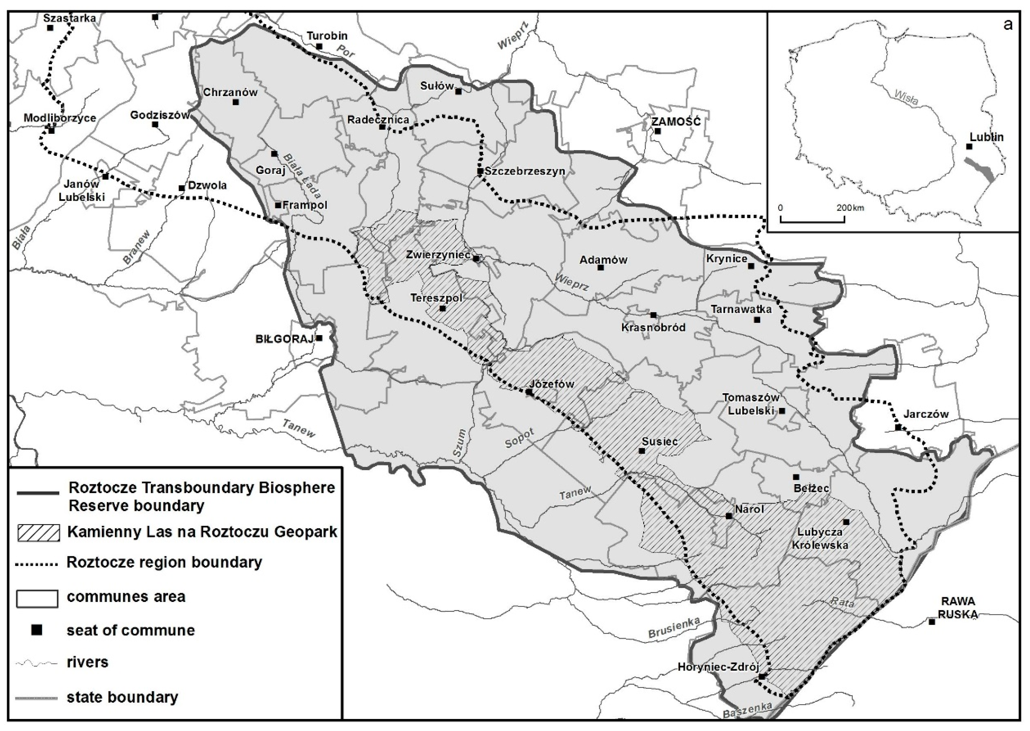
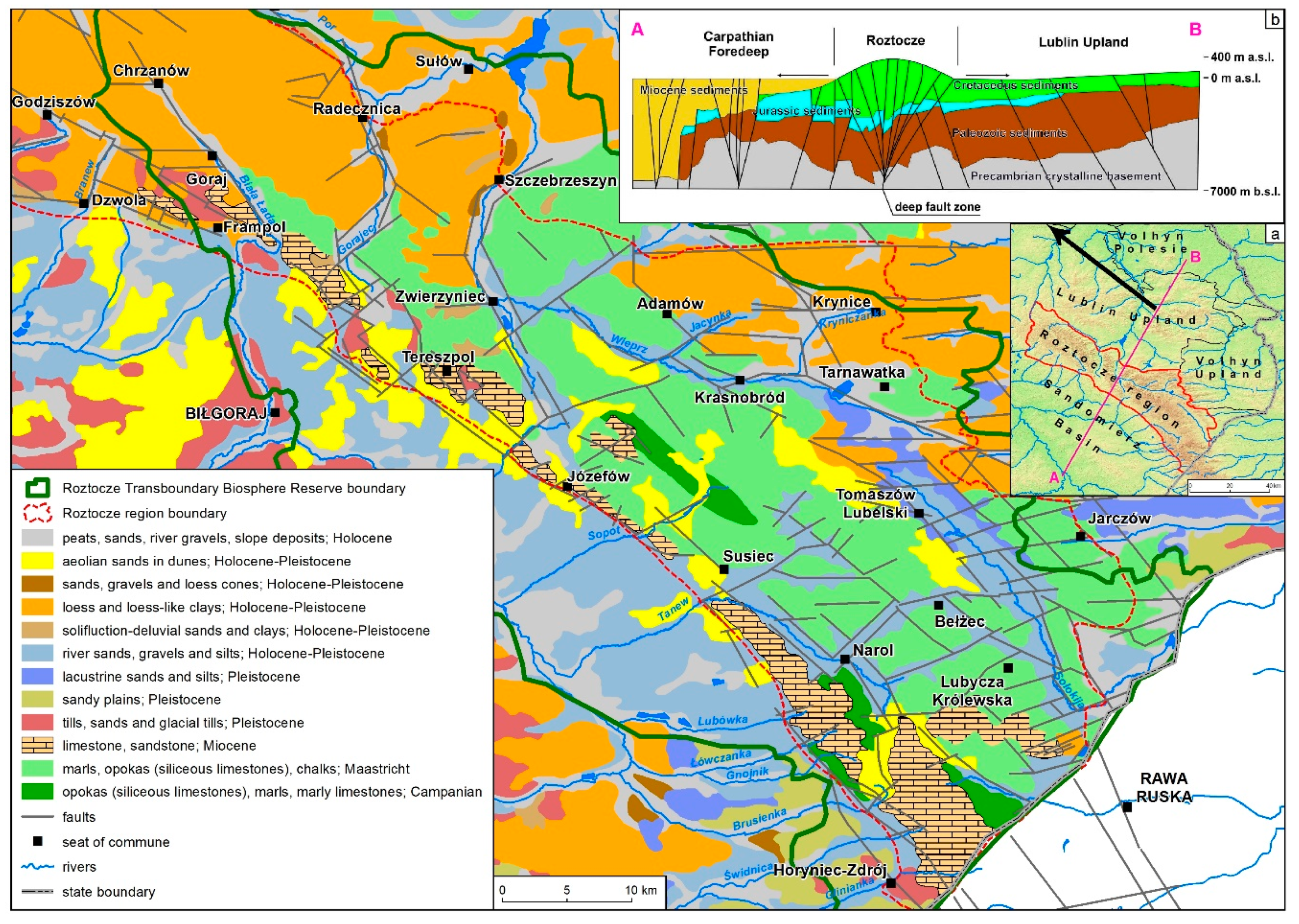
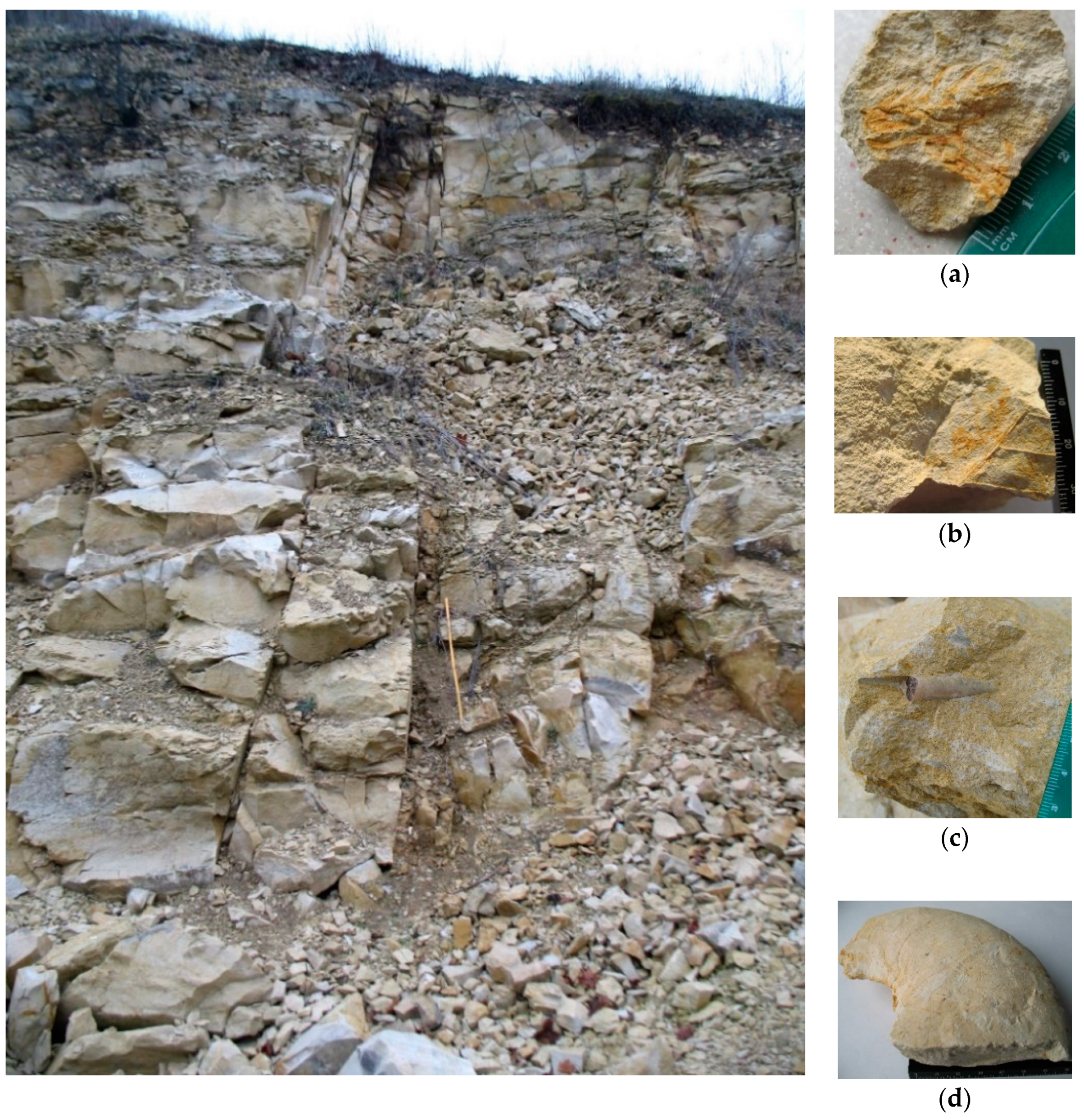
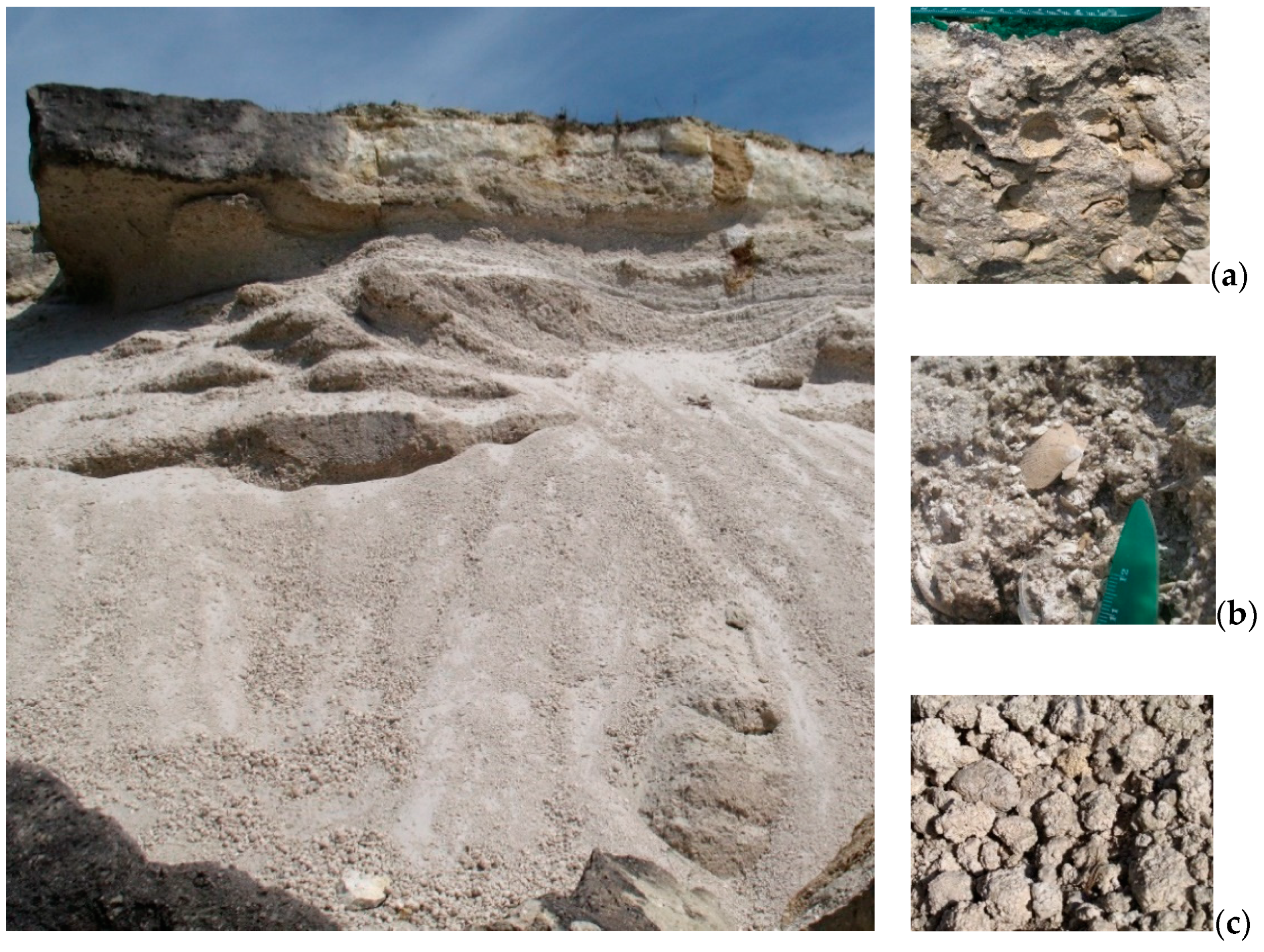
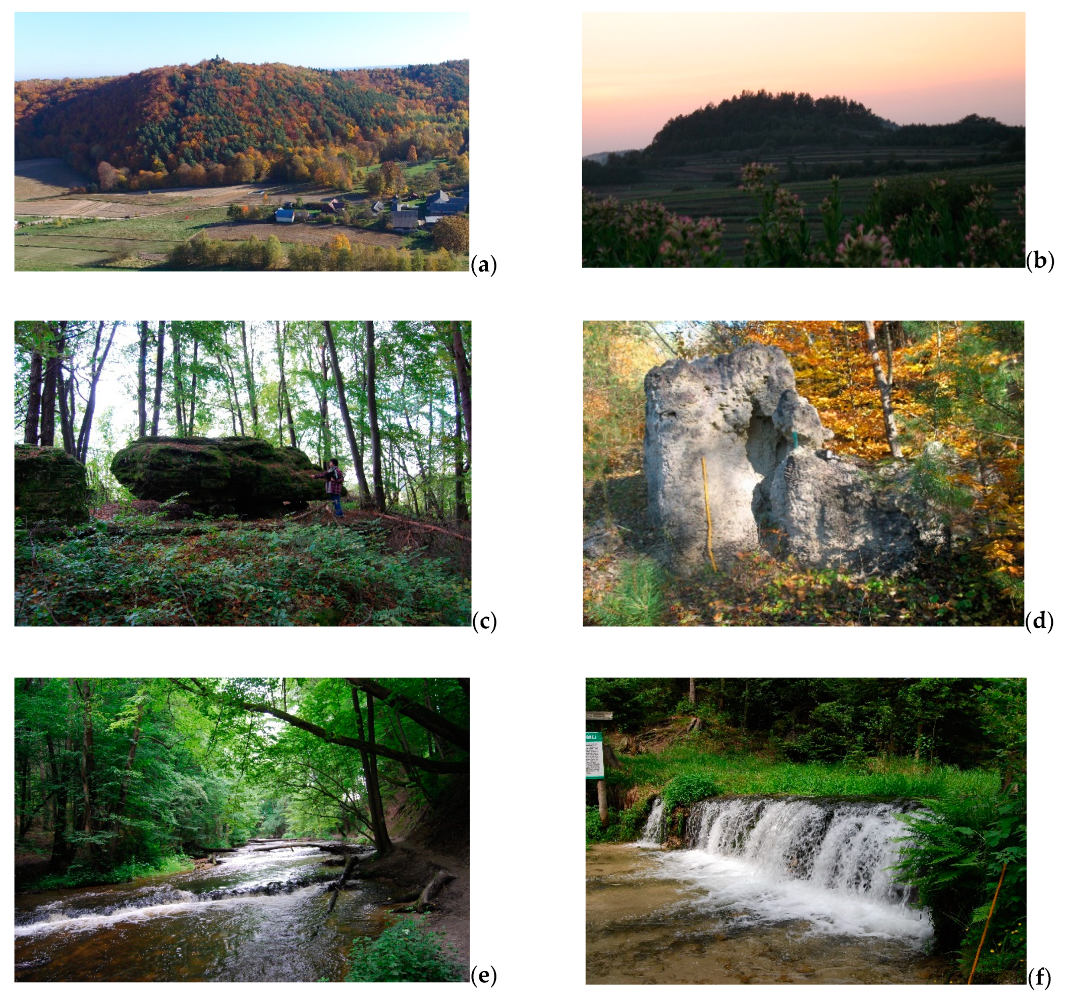
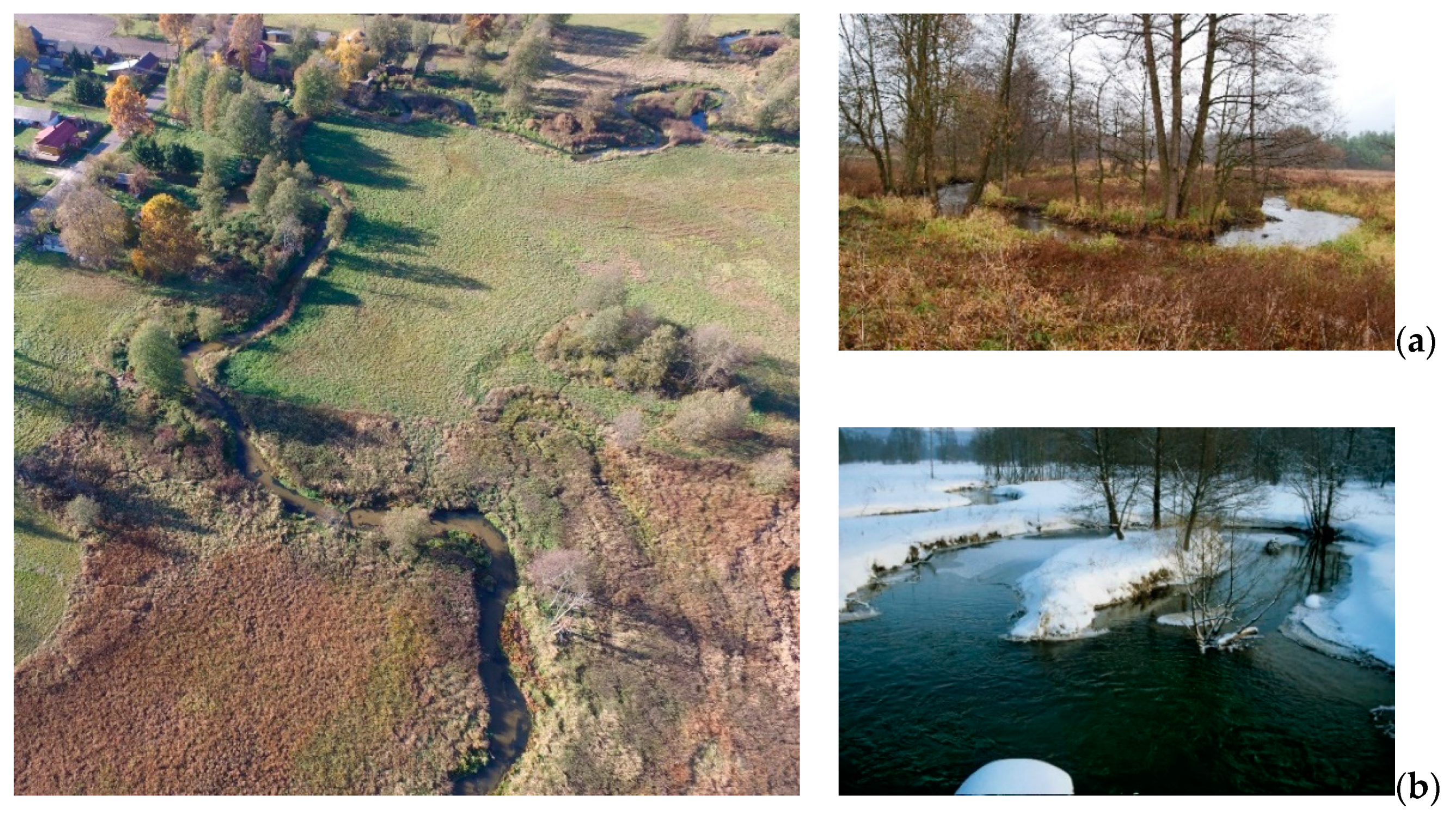
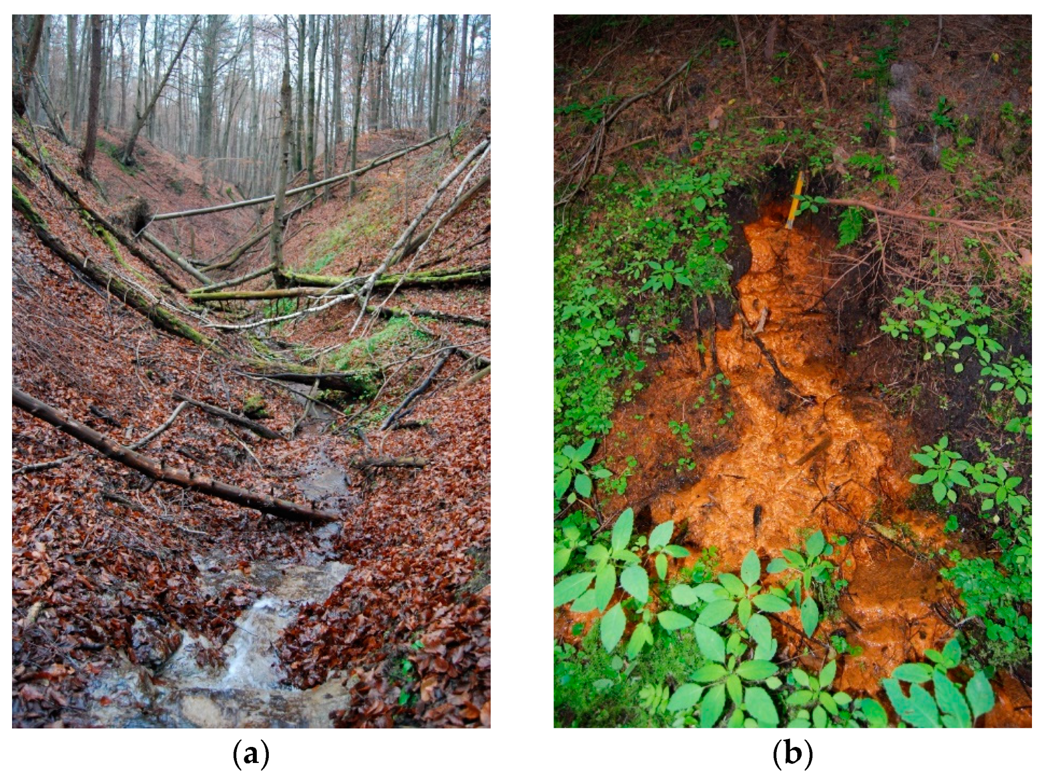
2.1. Geotourism Resources of the Roztocze TBR


2.2. Materials
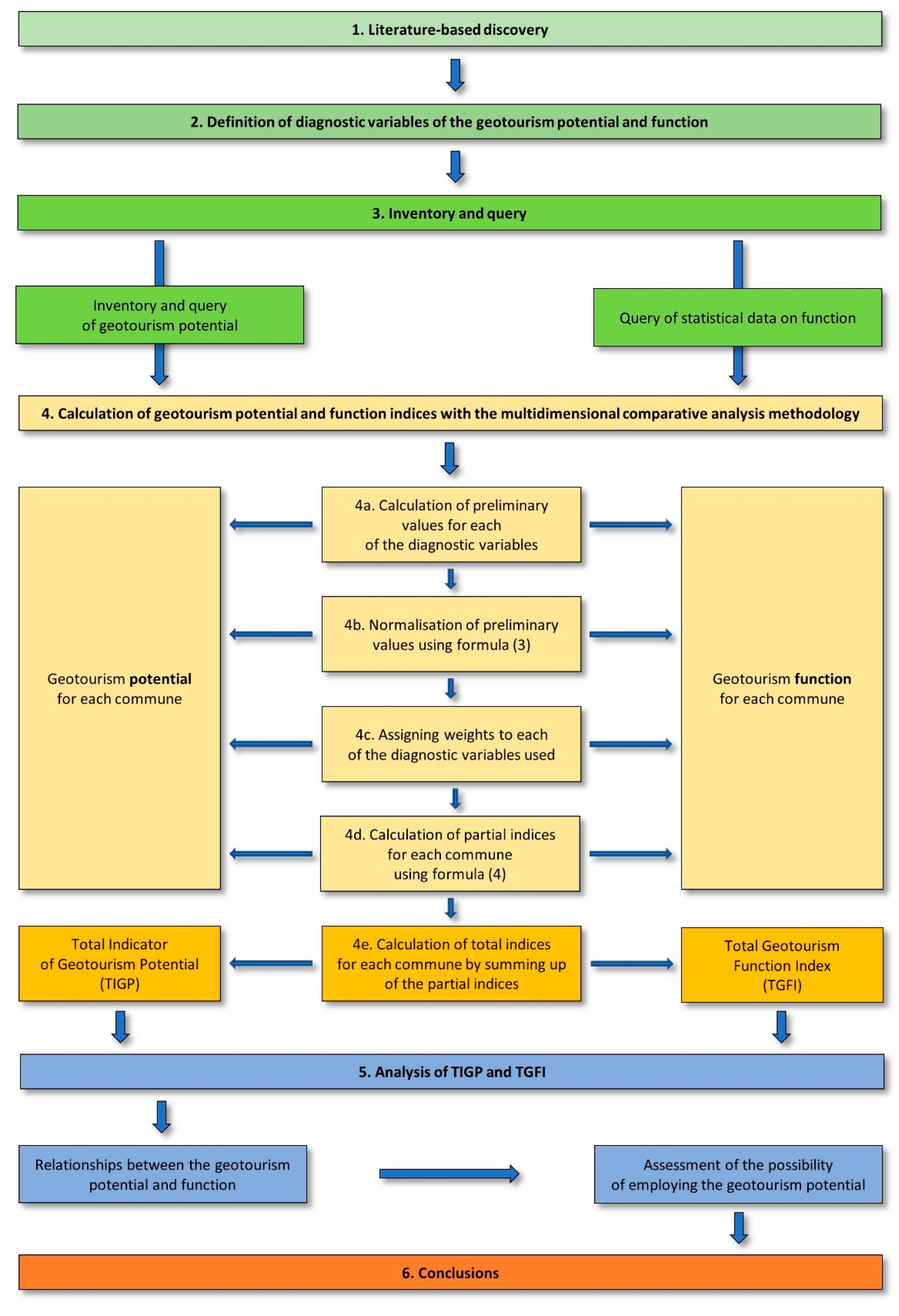
2.3. Methods
3. Results
3.1. Diversity of the Geotourism Potential in the Roztocze TBR
3.2. Diversity of the Geotourism Function Based on the Number of Users of Resources and Products
4. Discussion
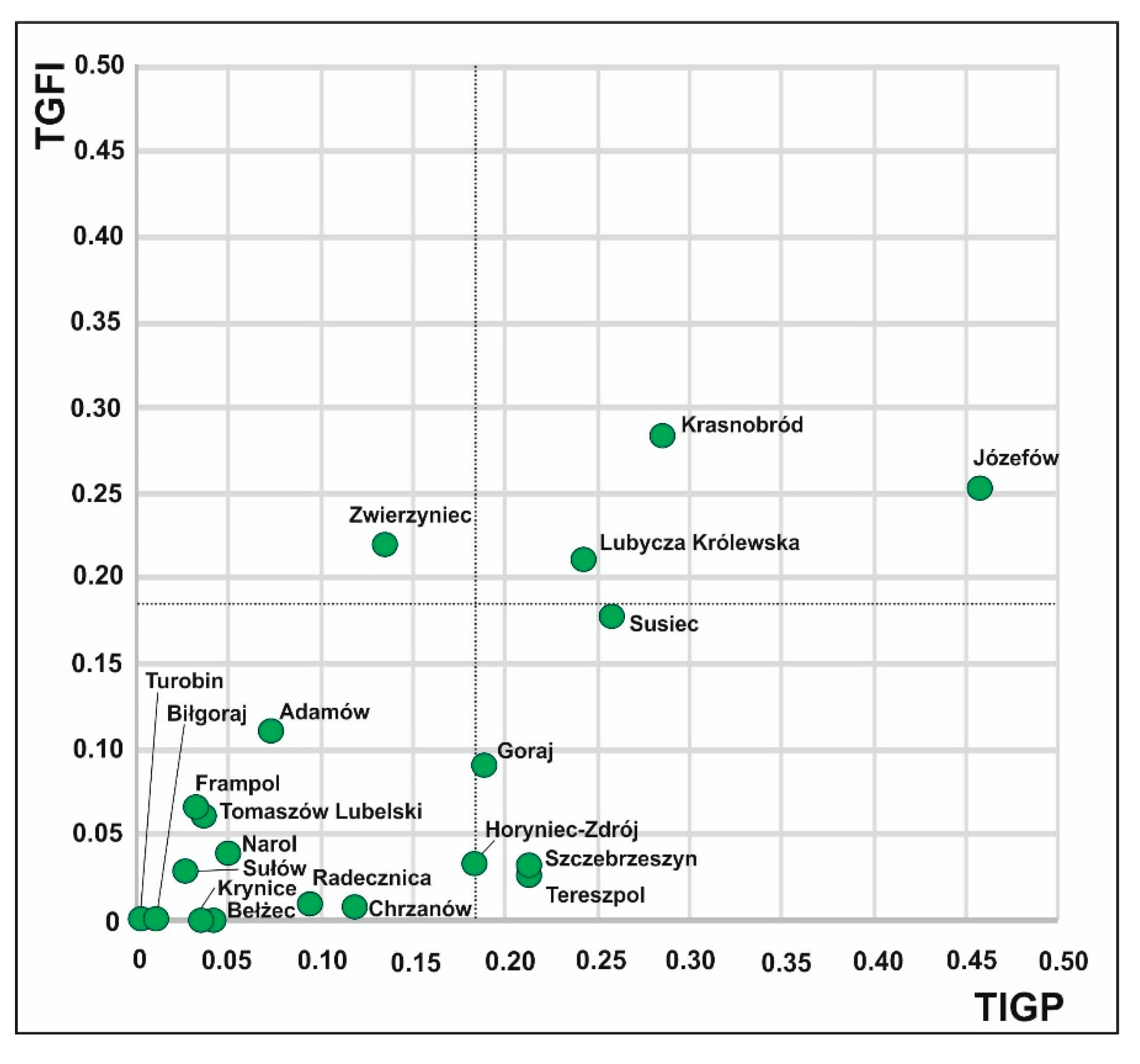
4.1. Relationships between the Geotourism Potential and Function
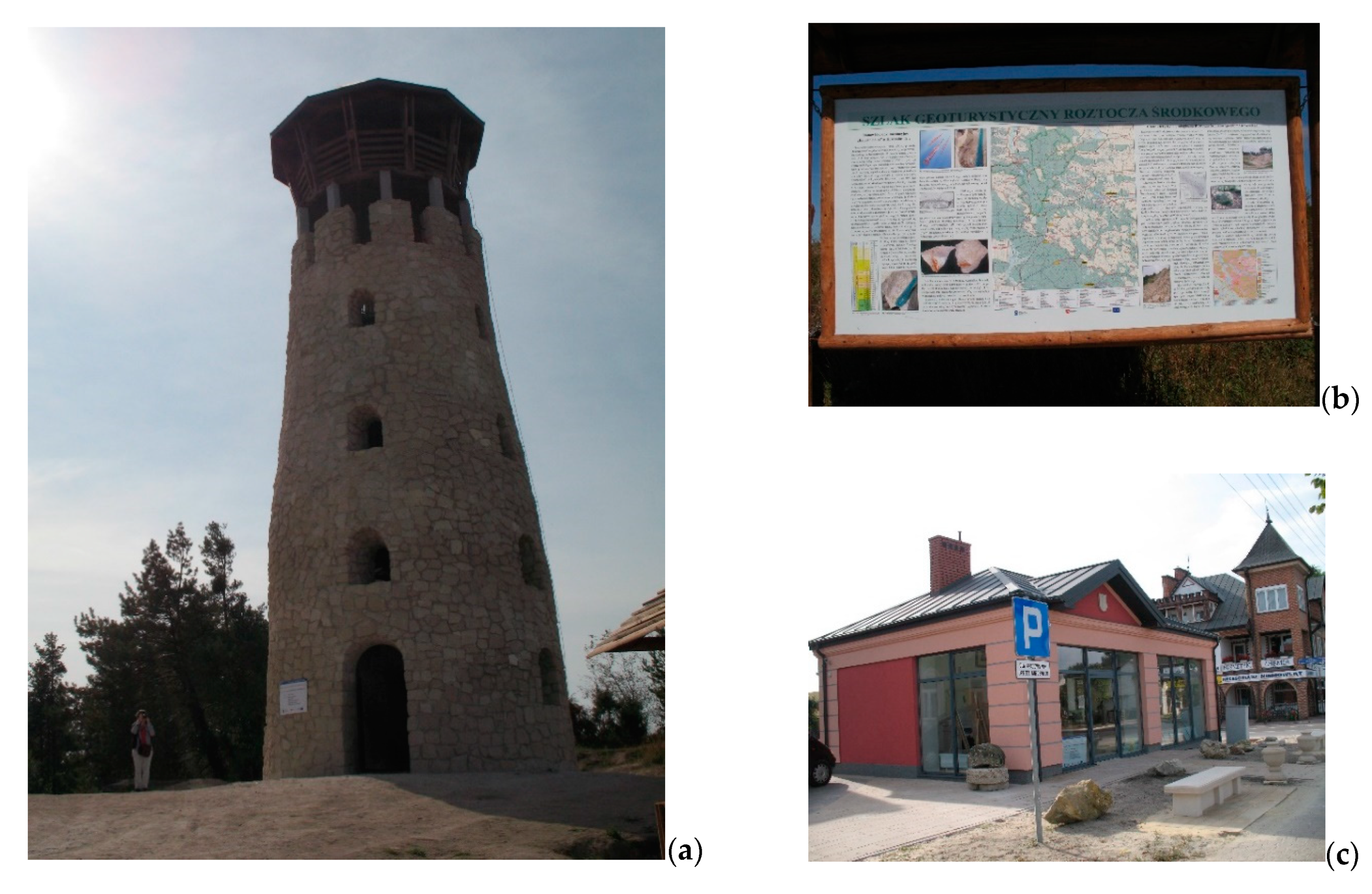
4.2. Assessment of the Possibility of Employing the Geotourism Potential of the Roztocze TBR for Establishment the “Kamienny Las na Roztoczu” Geopark
5. Conclusions
Funding
Institutional Review Board Statement
Informed Consent Statement
Data Availability Statement
Acknowledgments
Conflicts of Interest
References
- Bushell, R.; Staiff, R.; Eagles, P.F.J. Tourism and protected areas: Benefits beyond boundaries. In Tourism and Protected Area: Benefits Beyond Boundaries; Bushell, R., Eagles, P.J.F., Eds.; CABI International: Wallingford, UK, 2007; pp. 1–11. [Google Scholar]
- Towards a Green Economy. Pathways to Sustainable Development and Poverty Eradication. A Synthesis for Policy Makers. UNEP. 2011. Available online: https://sustainabledevelopment.un.org/content/documents/126GER_synthesis_en.pdf (accessed on 15 November 2020).
- Hall, C.M.; Piggin, R. World Heritage sites: Managing the brand. In Managing Visitor Attractions: New Directions; Fyall, A., Garrod, B., Leask, A., Eds.; Butterworth Heinemann: Oxford, UK, 2003; pp. 203–219. [Google Scholar]
- Ryan, J.; Silvanto, S. The World Heritage site list: The making and management of a brand. Place Brand. Public Dipl. 2009, 5, 290–300. [Google Scholar] [CrossRef]
- Ryan, J.; Silvanto, S.; Seitz, V. The promotion of UNESCO biosphere reserves as tourist destinations: A preliminary examination of trends and implications. Int. J. Bus. Glob. 2013, 10, 309–324. [Google Scholar] [CrossRef]
- Gonzalez-Tejada, C.; Du, Y.; Read, M.; Girault, Y. From nature conservation to geotourism development: Examining ambivalent attitudes towards UNESCO directives with the global geopark network. Int. J. Geoherit. 2017, 5, 1–20. [Google Scholar] [CrossRef]
- Ryan, J.; Silvanto, S. A brand for all the nations: The development of the World Heritage brand in emerging markets. Mark. Intell. Plan. 2011, 29, 305–318. [Google Scholar] [CrossRef]
- Solon, J.; Borzyszkowski, J.; Bidłasik, M.; Richling, A.; Badora, K.; Balon, J.; Brzezińska-Wójcik, T.; Chabudziński, Ł.; Dobrowolski, R.; Grzegorczyk, I.; et al. Physico-geographical mesoregions of Poland—Verification and adjustment of boundaries on the basis of contemporary spatial data. Geogr. Political 2018, 91, 143–170. [Google Scholar] [CrossRef]
- Roztoczański Park Narodowy. Available online: http://roztoczanskipn.pl/pl/45-aktualnosci/501-transgraniczny-rezerwat-biosfery-roztocze (accessed on 15 November 2020).
- Roztocze Transboundary Biosphere Reserve, Poland/Ukraine. Available online: https://en.unesco.org/biosphere/eu-na/roztocze (accessed on 15 November 2020).
- Hawkins, D.E.; Lamoureux, K. Global growth and magnitude of ecotourism. In The Encyclopedia of Ecotourism; Weaver, D.B., Ed.; CABI Publishing: Wallingford, UK, 2001; pp. 63–72. [Google Scholar] [CrossRef]
- Buckley, R.C. Case Studies in Ecotourism; CABI Publishing: Wallingford, UK, 2003. [Google Scholar]
- Hose, T.A. European “Geotourism”—Geological interpretation and geoconservation promotion for tourist. In Geological Heritage: Its Conservation and Management; Barretino, D., Wimbledon, W.P., Gallego, E., Eds.; Instituto Tecnológico Geominero de España: Madrid, Spain, 2000; pp. 127–146. [Google Scholar]
- Dowling, R.K. Global geotourism—An emerging form of sustainable tourism. Czech J. Tour. 2013, 2, 59–79. [Google Scholar] [CrossRef]
- Farsani, N.T.; Coelho, C.; Costa, C. Geotourism and geoparks as novel strategies for socio-economic development in rural areas. Int. J. Tour. Res. 2011, 13, 68–91. [Google Scholar] [CrossRef]
- Newsome, D.; Dowling, R.K.; Leung, Y.F. The nature and management of geotourism: A case study of two established iconic geotourism destinations. Tour. Manag. Perspect. 2012, 2–3, 19–27. [Google Scholar] [CrossRef]
- Dowling, R.K. Geotourism’s global growth. Geoheritage 2011, 3, 1–13. [Google Scholar] [CrossRef]
- Neto de Carvalho, C.; Rodrigues, J.C.; Canilho, S.; Amado, S. Geopark Naturtejo, bajo los auspicios de la UNESCO: La construcción participativa de un destino geoturístico en Portugal. Tierra Y Tecnol. 2011, 40, 52–56. [Google Scholar]
- Ólafsdóttir, R.; Tverijonaite, E. Geotourism: A Systematic Literature Review. Geosciences 2018, 8, 234. [Google Scholar] [CrossRef]
- Bentivenga, M.; Cavalcante, F.; Mastronuzzi, G.; Palladino, G.; Prosser, G. Geoheritage: The Foundation for Sustainable Geotourism. Geoheritage 2019, 11, 1367–1369. [Google Scholar] [CrossRef]
- Štrba, L.; Kolačkovská, J.; Kudelas, D.; Kršák, B.; Sidor, C. Geoheritage and Geotourism Contribution to Tourism Development in Protected Areas of Slovakia—Theoretical Considerations. Sustainability 2020, 12, 2979. [Google Scholar] [CrossRef]
- Ólafsdóttir, R. Geotourism. Geosciences 2019, 9, 48. [Google Scholar] [CrossRef]
- Lazzari, M.; Aloia, A. Geoparks, geoheritage and geotourism: Opportunities and tools in sustainable development of the territory. Geoj. Tour. Geosites 2014, 13, 8–9. [Google Scholar]
- Dowling, R.K.; Newsome, D. (Eds.) Geotourism; Elsevier Butterworth-Heinemann: Oxford, UK, 2006. [Google Scholar]
- Rodrigues, J.; de Carvalho, C.N.; Ramos, M.; Ramos, R.; Vinagre, A.; Vinagre, H. Geoproducts—Innovative development strategies in UNESCO Geoparks: Concept, implementation methodology, and case studies from Naturtejo Global Geopark, Portugal. Int. J. Geoheri. Parks 2021, in press. [Google Scholar] [CrossRef]
- Palladino, G.; Prosser, G.; Bentivenga, M. The geological itinerary of Sasso di Castalda: A journey into the geological history of the Southern Apennine thrust-belt (Basilicata-Southern Italy). Geoheritage 2013, 5, 47–58. [Google Scholar] [CrossRef]
- Buckley, R.; Robinson, J.; Carmody, J.; King, N. Monitoring for management of conservation and recreation in Australian protected areas. Biodivers. Conserv. 2008, 17, 3589–3606. [Google Scholar] [CrossRef]
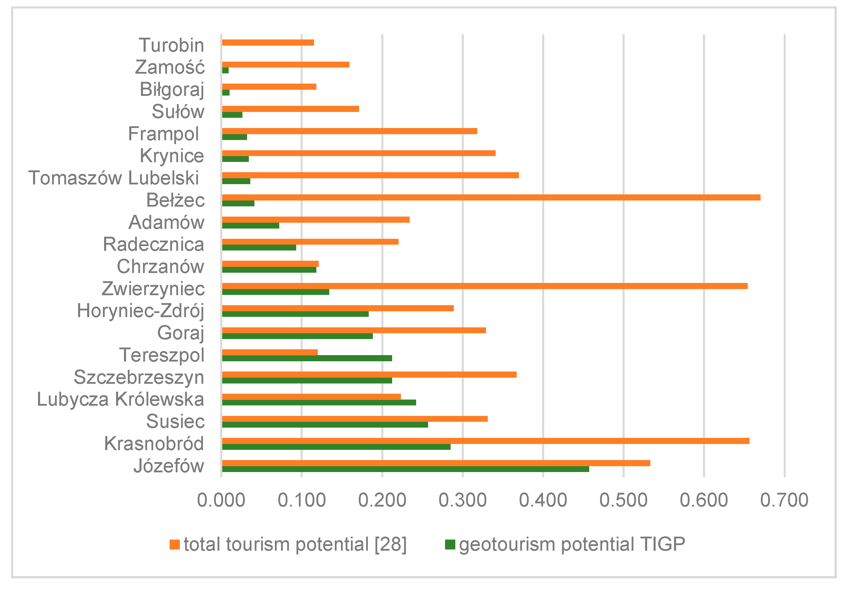
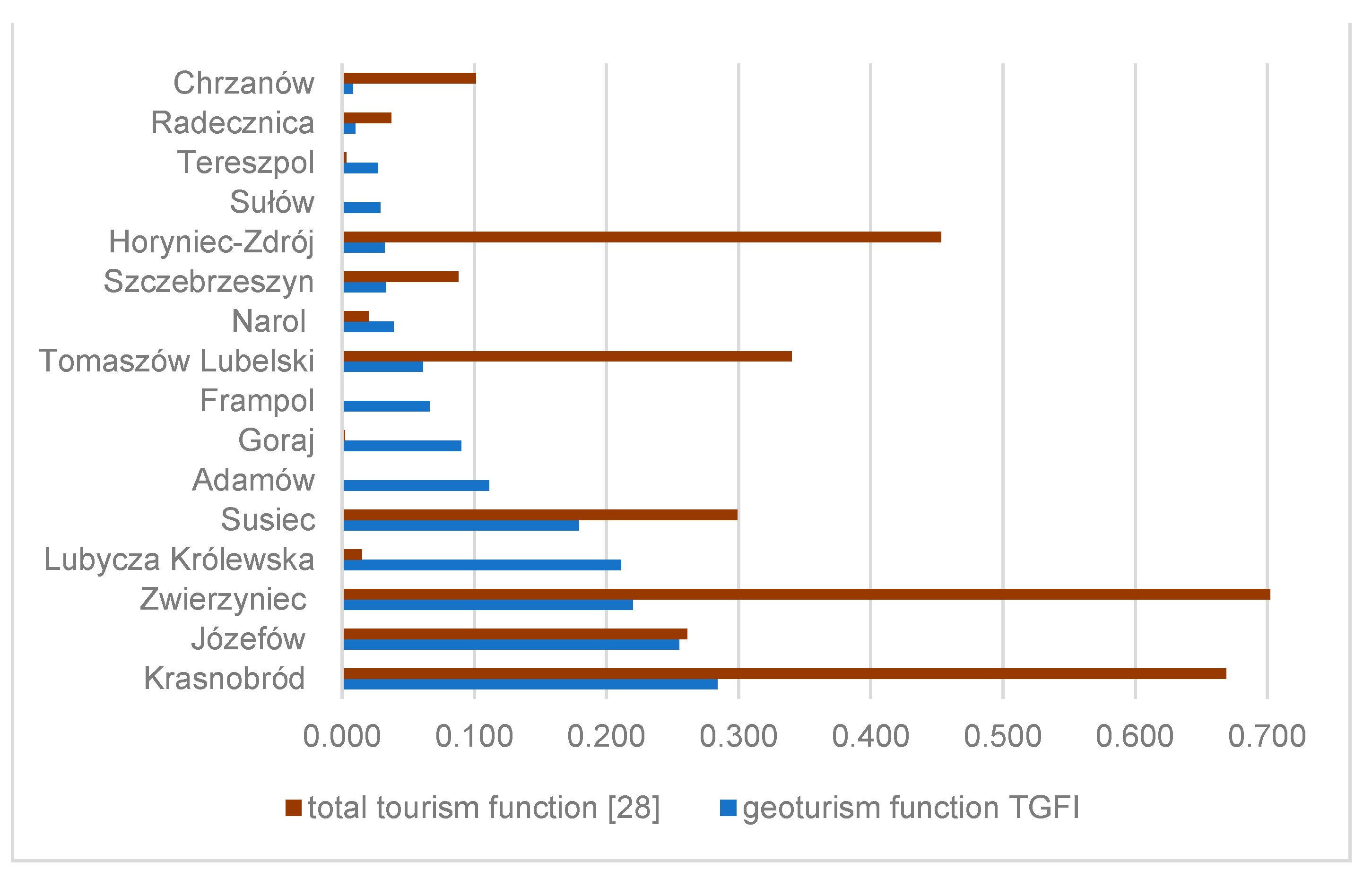
- Brzezińska-Wójcik, T.; Skowronek, E.; Świeca, A. Diversity of the tourism potential and functions in the Roztocze region. Econ. Probl. Tour. 2017, 40, 65–81. [Google Scholar] [CrossRef][Green Version]
- Krąpiec, M.; Jankowski, L.; Margielewski, W.; Urban, J.; Krąpiec, P. The Stone Forest (Kamienny Las) Geopark in Roztocze and its geoturistic values. Prz. Geol. 2012, 60, 468–479. [Google Scholar]
- Berthelsen, A. From Precambrian to Variscan Europe. In A Continent Revealed. The European Geotraverse; Blundell, D., Freeman, R., Mueller, S., Eds.; University Press: Cambridge, UK, 1992; pp. 153–164. [Google Scholar]
- Malinowski, J.; Mojski, J.E. Mapa Geologiczna Polski 1:200,000, ark. Lublin, A—Mapa Utworów Powierzchniowych; Wydawnictwa Geologiczne: Warszawa, Poland, 1981. [Google Scholar]
- Rzechowski, J.; Kubica, B. Mapa Geologiczna Polski 1:200,000, ark. Tomaszów Lubelski, Dołhobyczów. A—Mapa Utworów Powierzchniowych; Wydawnictwo Kartograficzne Polskiej Agencji Ekologicznej, S.A.: Warszawa, Poland, 1996. [Google Scholar]
- Margielewski, W.; Jankowski, L.; Krąpiec, M.; Garecka, M.; Hałas, S.; Urban, J. Analysis of reworked sediments as a basis of the Palaeogene-Neogene palaeogeography interpretation: Case study of the Roztocze region (SE Poland). Sediment. Geol. 2017, 352, 14–29. [Google Scholar] [CrossRef]
- Cieśliński, S.; Kubica, B.; Rzechowski, J. Mapa Geologiczna Polski. 1:200,000, ark. Tomaszów Lubelski, Dołhobyczów. B—Mapa bez Utworów Czwartorzędowych; Wydawnictwo Kartograficzne Polskiej Agencji Ekologicznej, S.A.: Warszawa, Poland, 1996. [Google Scholar]
- Buraczyński, J.; Krzowski, Z. Middle Eocene in the Sołokija graben on Roztocze Upland. Kwart. Geol. 1994, 38, 739–753. [Google Scholar]
- Wysocka, A. Clastic Badenian deposits and sedimentary environments of the Roztocze Hills across the Polish-Ukrainian border. Acta Geol. Pol. 2002, 52, 535–563. [Google Scholar]
- Kłusek, M. Fossil wood from the Roztocze region (Miocene, SE Poland)—A tool for palaeoenvironmental reconstruction. Geol. Q. 2006, 50, 465–474. [Google Scholar]
- Buraczyński, J. Roztocze. Budowa–Rzeźba–Krajobraz; Zakład Geografii Regionalnej: Lublin, Poland, 1997. [Google Scholar]
- Brzezińska-Wójcik, T.; Kociuba, W. Transformation of the Roztocze segment of the Wieprz river valley (SE Poland) in the Pleistocene. Prz. Geol. 2001, 49, 257–266. [Google Scholar]
- Karczmarz, K.; Popiel, J.S. Wstępne badania nad florą górnokredową Roztocza. Ann. Umcs 1966, 21, 269–278. [Google Scholar]
- Halamski, A.T. Latest Cretaceous leaf floras from southern Poland and western Ukraine. Acta Palaeontol. Pol. 2013, 58, 407–443. [Google Scholar] [CrossRef]
- Cieśliński, S. Szczegółowa Mapa Geologiczna Polski 1:50,000, ark. Zakrzówek (822); Państwowy Instytut Geologiczny: Warszawa, Poland, 1993.
- Brzezińska-Wójcik, T. Morfotektonika w Annopolsko-Lwowskim Segmencie pasa Wyżynnego w Świetle Analizy Cyfrowego Modelu Wysokościowego oraz Wskaźników Morfometrycznych; Uniwersytet Marii Curie Skłodowskiej: Lublin, Poland, 2013; Available online: https://books-box.com/katalog/wydawnictwo/wydawnictwo-uniwersytetu-marii-curie-sklodowskiej-w-lublinie?page=16 (accessed on 20 November 2020).
- Pisera, A. Palaeoecology and lithogenesis of the Middle Miocene (Badenian) algal-vermetid reefs from the Roztocze Hills, southeastern Poland. Acta Geol. Pol. 1985, 35, 89–155. [Google Scholar]
- Geostanowiska PIG-PIBCBDG. Available online: https://cbdgportal.pgi.gov.pl/geostanowiska/ (accessed on 20 November 2020).
- Brzezińska-Wójcik, T.; Hnatiuk, R. Rzeźba terenu. In Roztocze—Przyroda i Człowiek; Grabowski, T., Harasimiuk, M., Kaszewski, B.M., Kravchuk, Y., Lorens, B., Michalczyk, Z., Shabliy, O., Eds.; Roztoczański Park Narodowy: Zwierzyniec, Poland, 2015; pp. 75–91. [Google Scholar]
- Kociuba, W.; Brzezińska-Wójcik, T. Zarys paleogeografii roztoczańskiego odcinka doliny Wieprza (SE Polska) w czwartorzędzie. Ann. Umcs 2002, 54, 49–82. [Google Scholar]
- Superson, J. Funkcjonowanie Systemu Fluwialnego Wyżynnej Części Dorzecza Wieprza w Zlodowaceniu Wisły; Rozprawy Habilitacyjne Wydziału BiNoZ UMCS: Lublin, Poland, 1996. [Google Scholar]
- Buraczyński, J. Les entailles d’erosion recentes (ravins) du Roztocze Occidental. Biul. Lubel. Tow. Nauk. 1965, 3, 23–26. [Google Scholar]
- Chmiel, S.; Michalczyk, Z.; Turczyński, M. Ocena jakości wód podziemnych i powierzchniowych Roztocza. Ann. UMCS 1997, 52, 77–102. [Google Scholar]
- Ciężkowski, W.; Porwisz, B.; Zuber, A. Geneza i wiek wód siarczkowych Horyńca Zdroju i Ratoszyna. Współcz. Probl. Hydrogeol. 2003, 9, 95–102. [Google Scholar]
- PIG-PIBCBDG. Available online: http://geostanowiska.pgi.gov.pl/gsapp_v2/ObjectDetails.aspx?id=2166 (accessed on 20 November 2020).
- Roztoczański Park Narodowy. Available online: http://roztoczanskipn.pl/pl/ (accessed on 26 November 2020).
- Zespół Lubelskich Parków Krajobrazowych. Available online: https://parki.lubelskie.pl/ (accessed on 28 November 2020).
- Lokalna Organizacja Turystyczna Roztocze. Available online: http://roztoczewita.pl/ (accessed on 28 November 2020).
- Lokalna Organizacja Turystyczna Zamość i Roztocze. Available online: https://pl-pl.facebook.com/LOTZamosciRoztocze/ (accessed on 28 November 2020).
- Józefowska Kawaleria Rowerowa. Available online: http://jkr.org.pl/ (accessed on 2 December 2020).
- Polskie Towarzystwo Turystyczno-Krajoznawcze. Oddział w Zamościu. Available online: http://www.zamosc.pttk.pl/ (accessed on 5 December 2020).
- Powiat Biłgorajski. Available online: https://www.bilgorajski.pl/ (accessed on 2 December 2020).
- Powiat Lubaczowski. Available online: https://powiatlubaczowski.pl/ (accessed on 12 December 2020).
- Powiat Tomaszowski. Available online: https://www.powiat-tomaszowski.com.pl/ (accessed on 2 December 2020).
- Powiat Zamojski. Available online: http://www.powiatzamojski.pl/ (accessed on 15 December 2020).
- Gmina Batorz. Available online: http://www.batorz.gmina.pl/index.php/muzeum-wiejskie (accessed on 2 December 2020).
- Restauracja Klemens. Available online: http://restauracjaklemens.pl/muzeum-skarbow-ziemi-i-morza (accessed on 5 January 2021).
- Zagroda Guciów. Available online: https://www.guciow.pl/muzeum (accessed on 5 January 2021).
- Powiat Tomaszowski. Available online: https://www.powiat-tomaszowski.com.pl/aktualnosci/2020/06/muzeum-skamienialych-drzew-w-siedliskach/ (accessed on 5 January 2021).
- Najafabadei, M.E.; Kia, E.A.; Alizadeh, S.J.; Kefayatmotlagh, O. Assessment of ecotourism and geo-tourism potentials the Chahardangeh region (in the Mazandaran province) using the SWOT model. Cumhuriyet Sci. J. 2015, 36, 274–288. [Google Scholar]
- Antić, A.; Tomić, N. Geoheritage and geotourism potential of the Homolje area (eastern Serbia). Acta Geotur. 2017, 8, 67–78. [Google Scholar] [CrossRef][Green Version]
- Pilogallo, A.; Nolè, G.; Amato, F.; Saganeiti, L.; Bentivenga, M.; Palladino, G.; Scorza, F.; Murgante, B.; Las Casas, G. Geotourism as a Specialization in the Territorial Context of the Basilicata Region (Southern Italy). Geoheritage 2019, 11, 1435–1445. [Google Scholar] [CrossRef]
- Greco, S.; Ishizaka, A.; Tasiou, M.; Torrisi, G. On the Methodological Framework of Composite Indices: A Review of the Issues of Weighting, Aggregation, and Robustness. Soc. Indic. Res. 2019, 141, 61–94. [Google Scholar] [CrossRef]
- Gołembski, G.; Nawrot, Ł.; Olszewski, M.; Zmyślony, P. Investment decisions in the early stages of the tourism area life cycle. Tourism 2010, 58, 361–377. Available online: https://hrcak.srce.hr/63594 (accessed on 17 February 2021).
- Słomka, T. Geodiversity of Poland. Pol. Geol. Rev. 2008, 56, 584–587. [Google Scholar]
- Ollier, C. Problems of geotourism and geodiversity. Quaest. Geogr. 2012, 31, 57–61. [Google Scholar] [CrossRef]
- Derek, M. Funkcja Turystyczna Jako Czynnik Rozwoju Lokalnego w Polsce. Ph.D. Thesis, Wydział Geografii i Studiów Regionalnych UW, Warszawa, Poland, 2008. Available online: http://wgsr.uw.edu.pl/wgsr/wp-content/uploads/2018/11/1_pdfsam_doktorat-w-pdf.pdf (accessed on 20 November 2020).
- Durydiwka, M. Tourist function in rural areas of Poland. Spacial diversity and changing trends. Misc. Geogr. 2013, 17, 5–11. [Google Scholar] [CrossRef]
- Jafari, J. (Ed.) Encyclopedia of Tourism; Routledge: London, UK; New York, NY, USA, 2001. [Google Scholar]
- Gierliński, G.D.; Ploch, I.; Gawor-Biedowa, E.; Niedźwiedzki, G. The first evidence of dinosaur tracks in the Upper Cretaceous of Poland. Oryctos 2008, 8, 107–113. [Google Scholar]
- Jaroszewski, W. Sedymentacyjne przejawy mioceńskiej ruchliwości tektonicznej na Roztoczu Środkowym. Prz. Geol. 1977, 25, 418–427. Available online: https://geojournals.pgi.gov.pl/pg/article/view/21850/15533 (accessed on 28 December 2020).
- Brzezińska-Wójcik, T. Strategia hands-on activity w kreowaniu geoproduktów w kontekście edukacji, interpretacji i promocji geodziedzictwa na Roztoczu (środkowowschodnia Polska). Ekon. Probl. Tur. 2015, 29, 169–193. [Google Scholar]
- Urząd Marszałkowski Województwa Lubelskiego w Lublinie. Available online: https://promocja.lubelskie.pl/turystyka/regionalne-szlaki-rowerowe/ (accessed on 27 December 2020).
- Ponikiewski, A. Jaskiniowe Roztocze. Jaskinie 2009, 55, 28–30. [Google Scholar]
- Stowarzyszenie Przyjaciół Roztocza “Jastrzębia Zdebrz”. Available online: https://www.roztoczezachodnie.pl/lista_uczestnikow (accessed on 27 December 2020).
- Sobolewska, A.; Sztanke, M.; Pasternak, K. Składniki borowiny i jej właściwości lecznicze. Balneol. Polska 2007, 49, 93–98. [Google Scholar]
- Michalczyk, Z. (Ed.) Źródła Roztocza; Uniwersytet Marii Curie Skłodowskiej: Lublin, Poland, 1996. [Google Scholar]
- Wągrowski, A. Objaśnienia do Szczegółowej Mapy Geologicznej Polski 1:50,000, ark. Turobin (859); Wydawnictwa Kartograficzne Polskiej Agencji Ekologicznej, S.A.: Warszawa, Poland, 2001. [Google Scholar]
- Green Velo. Available online: https://greenvelo.pl/detal/1171-greenvelo-trasa-rowerowa-gminy-zamosc-na-skraju-roztocza (accessed on 27 November 2020).
- Miasto i Gmina Szczebrzeszyn. Available online: https://www.szczebrzeszyn.pl/dla-turysty/ (accessed on 10 December 2020).
- Gminny Ośrodek Kultury w Horyńcu-Zdroju. Available online: http://www.horyniec.naszgok.pl (accessed on 15 December 2020).
- Hose, T.A. Geotourism and Interpretation. In Geotourism; Dowling, R., Newsome, D., Eds.; Butterworth Heinemann; Elsevier Science: Oxford, UK, 1995; pp. 221–241. [Google Scholar]
- Kawałko, D. Józefowski ośrodek kamieniarski. In Przyczynki do etnografii Zamojszczyzny; Materiały Ogólnopolskiej Sesji Popularno-Naukowej w Zamościu: Zamość, Poland, 22–24.IX.1995 r.; pp. 46–61. Available online: http://biblioteka.teatrnn.pl/dlibra/Content/11058/Przyczynki_do_etnografii_Zamojszczyzny.pdf (accessed on 15 January 2021).
- Kaczmarek, J.; Stasiak, A.; Włodarczyk, B. Produkt Turystyczny. Pomysł, Organizacja, Zarządzanie, 2nd ed.; Polskie Wydawnictwo Ekonomiczne: Warszawa, Poland, 2010. [Google Scholar]


| Spheres | Sections | Stimulants y | Diagnostic Variable | Unit of Potential | Unit of Function | Communes | Weight of Variable |
|---|---|---|---|---|---|---|---|
| resources | disused and active quarries, outcrops | 1 | disused and active quarries of Late Cretaceous rocks | number of objects/1 km2 | number of tourists/ km² | Chrzanów, Frampol, Goraj, Radecznica, Turobin, Biłgoraj, Sułów, Szczebrzeszyn, Tereszpol, Adamów, Bełżec, Józefów, Krasnobród, Krynice, Susiec, Tarnawatka, Tomaszów Lubelski, Zamość, Zwierzyniec, Horyniec-Zdrój, Lubycza Królewska, Narol | 0.10 |
| 2 | disused and active quarries of Miocene rocks | 0.05 | |||||
| 3 | loess outcrops | 0.02 | |||||
| 4 | outcrops in dunes | 0.02 | |||||
| 5 | sites with petrified wood | 0.10 | |||||
| landforms | 6 | residual hills | number of objects/1 km2 | 0.02 | |||
| 7 | rocks and groups of rocks | 0.05 | |||||
| 8 | river valleys | 0.02 | |||||
| 9 | springs | 0.01 | |||||
| 10 | steep rapids (waterfalls) | 0.05 | |||||
| 11 | ravines in Miocene formations | km/1 km2 | 0.02 | ||||
| 12 | loess gullies | 0.02 | |||||
| 13 | caves | number of objects/1 km2 | 0.01 | ||||
| products | museums and natural collections | 14 | nature museums | 0.05 | |||
| 15 | educational centers | 0.10 | |||||
| 16 | other nature collections | 0.02 | |||||
| touristic and educational trails | 17 | hiking trails | km/1 km2 | 0.02 | |||
| 18 | cycling trails | 0.02 | |||||
| 19 | thematic routes related to geotourism resources | 0.10 | |||||
| 20 | educational routes | 0.10 | |||||
| events/ festivals | 21 | international events | number of events/1 km2 | 0.05 | |||
| 22 | national and regional events | 0.05 |
| Sections | Stimulants y | Diagnostic Variable | Preliminary Values of Features in Communes | ||
|---|---|---|---|---|---|
| Chrzanów | Frampol | Goraj | |||
| disused and active quarries, outcrops | 1 | disused and active quarries of Late Cretaceous rocks | 0.014 | 0.000 | 0.015 |
| 2 | disused and active quarries of Miocene rocks | 0.000 | 0.009 | 0.015 | |
| 3 | loess outcrops | 0.000 | 0.009 | 0.030 | |
| 4 | outcrops in dunes | 0.000 | 0.000 | 0.000 | |
| 5 | sites with petrified wood | 0.000 | 0.000 | 0.000 | |
| Sections | y | Diagnostic Variable | Normalized Values of Features in Communes | ||
|---|---|---|---|---|---|
| Chrzanów | Frampol | Goraj | |||
| disused and active quarries, outcrops | 1 | disused and active quarries of Late Cretaceous rocks | 0.875 | 0.000 | 0.938 |
| 2 | disused and active quarries of Miocene rocks | 0.000 | 0.093 | 0.155 | |
| 3 | loess outcrops | 0.000 | 0.009 | 0.030 | |
| 4 | outcrops in dunes | 0.000 | 0.000 | 0.000 | |
| 5 | sites with petrified wood | 0.000 | 0.000 | 0.000 | |
| Sections | y | Diagnostic Variable | Partial Indices of Features in Communes | ||
|---|---|---|---|---|---|
| Chrzanów | Frampol | Goraj | |||
| disused and active quarries, outcrops | 1 | disused and active quarries of Late Cretaceous rocks | 0.088 | 0.000 | 0.094 |
| 2 | disused and active quarries of Miocene rocks | 0.000 | 0.006 | 0.009 | |
| 3 | loess outcrops | 0.000 | 0.000 | 0.001 | |
| 4 | outcrops in dunes | 0.000 | 0.000 | 0.000 | |
| 5 | sites with petrified wood | 0.000 | 0.000 | 0.000 | |
| Summary indicator for the section | 0.088 | 0.006 | 0.104 | ||
| Values of the Total Indices of the Geotourism Potential (TIGP) and the Total Indices of the Geotourism Function (TGFI) | Interpretation | |
|---|---|---|
| Potential | Function | |
| >0.184 | very high | very well developed |
| 0.123–0.183 | high | well developed |
| 0.061–0.122 | moderate | moderately developed |
| 0.001–0.060 | low | poorly developed |
| 0.000 | none | not developed |
| Geotourism Potential | |||||||||
|---|---|---|---|---|---|---|---|---|---|
| Very High | High | Moderate | Low | None | |||||
| Communes | TIGP > 0.184 | Communes | TIGP 0.123–0.183 | Communes | TIGP 0.061–0.122 | Communes | TIGP 0.001–0.060 | Communes | TIGP 0.000 |
| Józefów | 0.457 | Horyniec-Zdrój | 0.183 | Chrzanów | 0.118 | Narol | 0.049 | Tarnawatka | 0.000 |
| Krasnobród | 0.285 | Zwierzyniec | 0.134 | Radecznica | 0.093 | Bełżec | 0.041 | ||
| Susiec | 0.257 | Adamów | 0.072 | Tomaszów Lubelski | 0.036 | ||||
| Lubycza Królewska | 0.242 | Krynice | 0.034 | ||||||
| Szczebrzeszyn | 0.212 | Frampol | 0.032 | ||||||
| Tereszpol | 0.212 | Sułów | 0.026 | ||||||
| Goraj | 0.188 | Biłgoraj | 0.010 | ||||||
| Zamość | 0.009 | ||||||||
| Turobin | 0.001 | ||||||||
| Communes | Resources | Product |
|---|---|---|
| Józefów |
|
|
| Krasnobród |
|
|
| Susiec |
|
|
| Lubycza Królewska |
|
|
| Szczebrzeszyn |
|
|
| Tereszpol |
|
|
| Goraj |
|
| Communes | Resources | Product |
|---|---|---|
| Horyniec-Zdrój |
|
|
| Zwierzyniec |
|
|
| Communes | Resources | Product |
|---|---|---|
| Chrzanów |
|
|
| Radecznica |
|
|
| Adamów |
|
|
| Communes | Resources | Product |
|---|---|---|
| Narol |
|
|
| Tomaszów Lubelski |
|
|
| Frampol |
|
|
| Sułów |
| |
| Turobin | ||
| Bełżec |
| |
| Biłgoraj |
| |
| Krynice |
| |
| Zamość |
|
|
| Geotourism Function | |||||||||
| Very Well Developed | Well Developed | Moderately Developed | Poorly Developed | Not Developed | |||||
| Communes | TIGP> 0.184 | Communes | TIGP0.123–0.183 | Communes | TIGP0.061–0.122 | Communes | TIGP0.001–0.060 | Communes | TIGP0.000 |
| Krasnobród | 0.284 | Susiec | 0.179 | Adamów | 0.111 | Narol | 0.039 | Bełżec | 0.000 |
| Józefów | 0.255 | Goraj | 0.090 | Szczebrzeszyn | 0.033 | Krynice | 0.000 | ||
| Zwierzyniec | 0.220 | Frampol | 0.066 | Horyniec-Zdrój | 0.032 | Biłgoraj | 0.000 | ||
| Lubycza Królewska | 0.211 | Tomaszów Lubelski | 0.061 | Sułów | 0.029 | Zamość | 0.000 | ||
| Tereszpol | 0.027 | Turobin | 0.000 | ||||||
| Radecznica | 0.010 | Tarnawatka | 0.000 | ||||||
| Chrzanów | 0.008 | ||||||||
| Communes | Resources | Product |
| Krasnobród |
|
|
| Józefów |
|
|
| Zwierzyniec |
|
|
| Lubycza Królewska |
|
|
| Communes | Resources | Product |
| Susiec |
|
|
| Communes | Resources | Product |
|---|---|---|
| Adamów |
|
|
| Goraj |
|
|
| Frampol |
| |
| Tomaszów Lubelski |
|
|
| Communes | Resources | Product |
|---|---|---|
| Narol |
|
|
| Szczebrzeszyn |
|
|
| Horyniec-Zdrój |
|
|
| Sułów |
|
|
| Tereszpol |
|
|
| Radecznica |
| |
| Chrzanów |
|
Publisher’s Note: MDPI stays neutral with regard to jurisdictional claims in published maps and institutional affiliations. |
© 2021 by the author. Licensee MDPI, Basel, Switzerland. This article is an open access article distributed under the terms and conditions of the Creative Commons Attribution (CC BY) license (http://creativecommons.org/licenses/by/4.0/).
Share and Cite
Brzezińska-Wójcik, T. Relationship between the Geotourism Potential and Function in the Polish Part of the Roztocze Transboundary Biosphere Reserve. Geosciences 2021, 11, 120. https://doi.org/10.3390/geosciences11030120
Brzezińska-Wójcik T. Relationship between the Geotourism Potential and Function in the Polish Part of the Roztocze Transboundary Biosphere Reserve. Geosciences. 2021; 11(3):120. https://doi.org/10.3390/geosciences11030120
Chicago/Turabian StyleBrzezińska-Wójcik, Teresa. 2021. "Relationship between the Geotourism Potential and Function in the Polish Part of the Roztocze Transboundary Biosphere Reserve" Geosciences 11, no. 3: 120. https://doi.org/10.3390/geosciences11030120
APA StyleBrzezińska-Wójcik, T. (2021). Relationship between the Geotourism Potential and Function in the Polish Part of the Roztocze Transboundary Biosphere Reserve. Geosciences, 11(3), 120. https://doi.org/10.3390/geosciences11030120