
Visitation Rate Analysis of Geoheritage Features from Earth Science Education Perspective Using Automated Landform Classification and Crowdsourcing: A Geoeducation Capacity Map of the Auckland Volcanic Field, New Zealand


Abstract
:1. Introduction
2. Disposition of Formal Decision Instruments
How Conservation Strategies and Urban Planning Look like Today
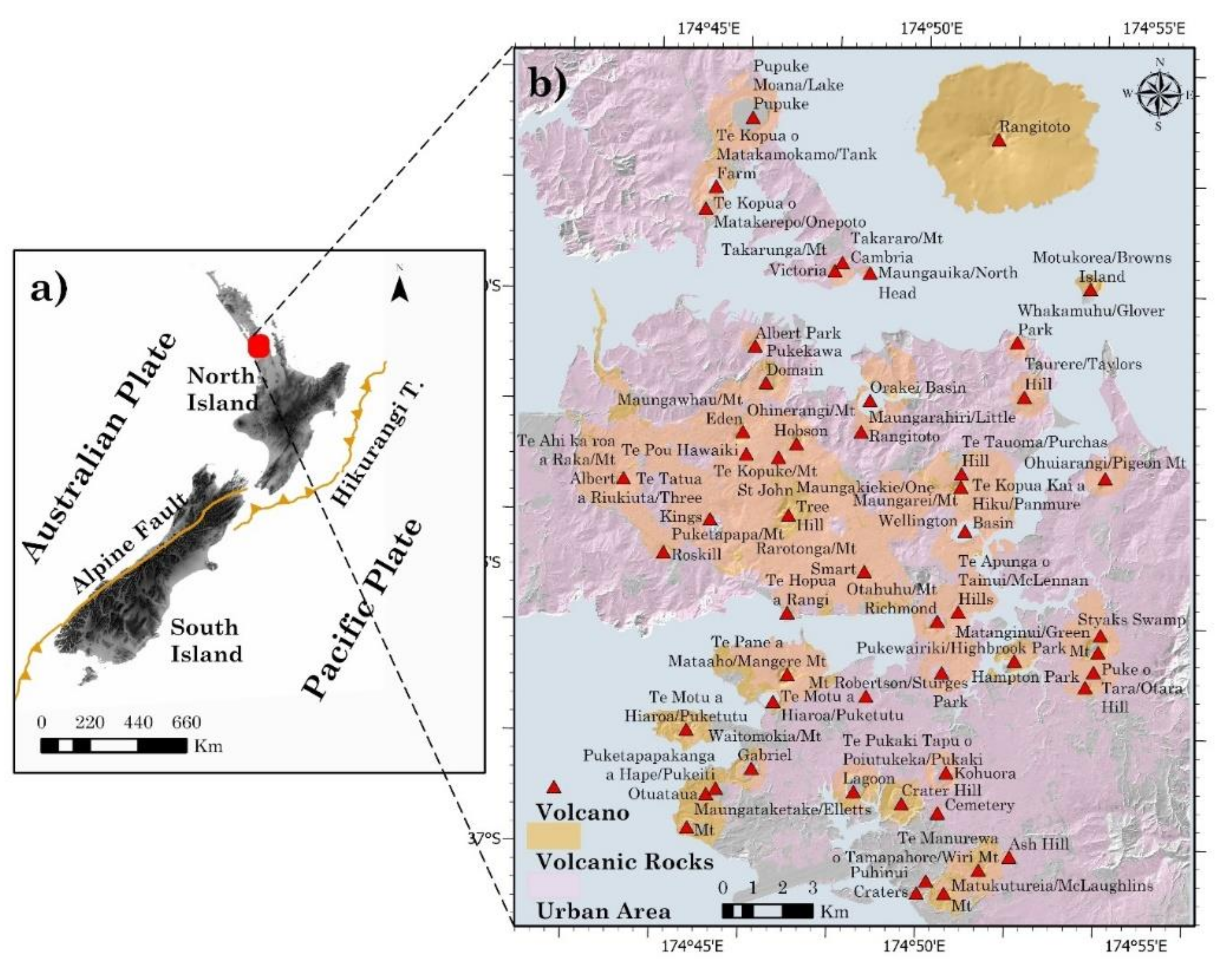
3. The Study Area
4. Methods and Results
4.1. Formal Decision Instruments and Community Endeavour
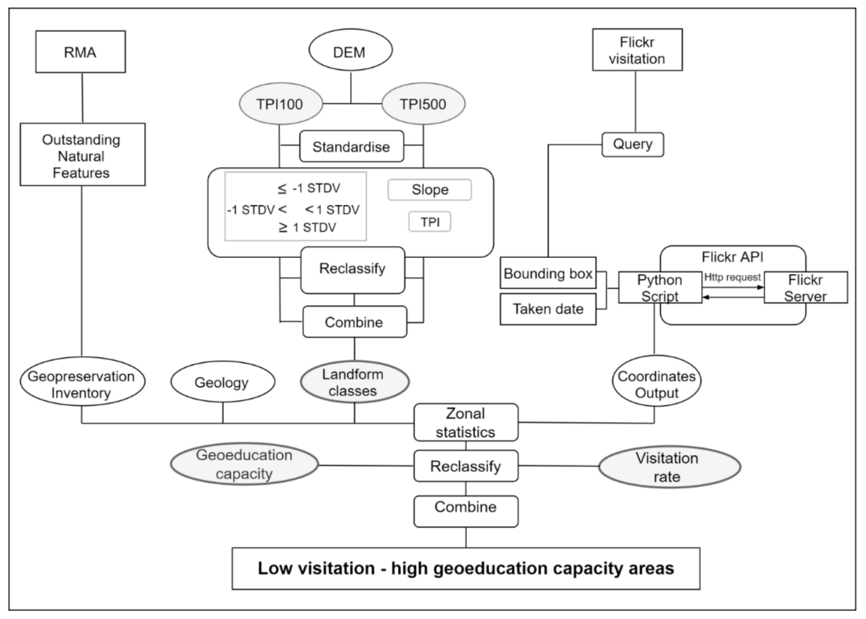
4.2. The Mapping
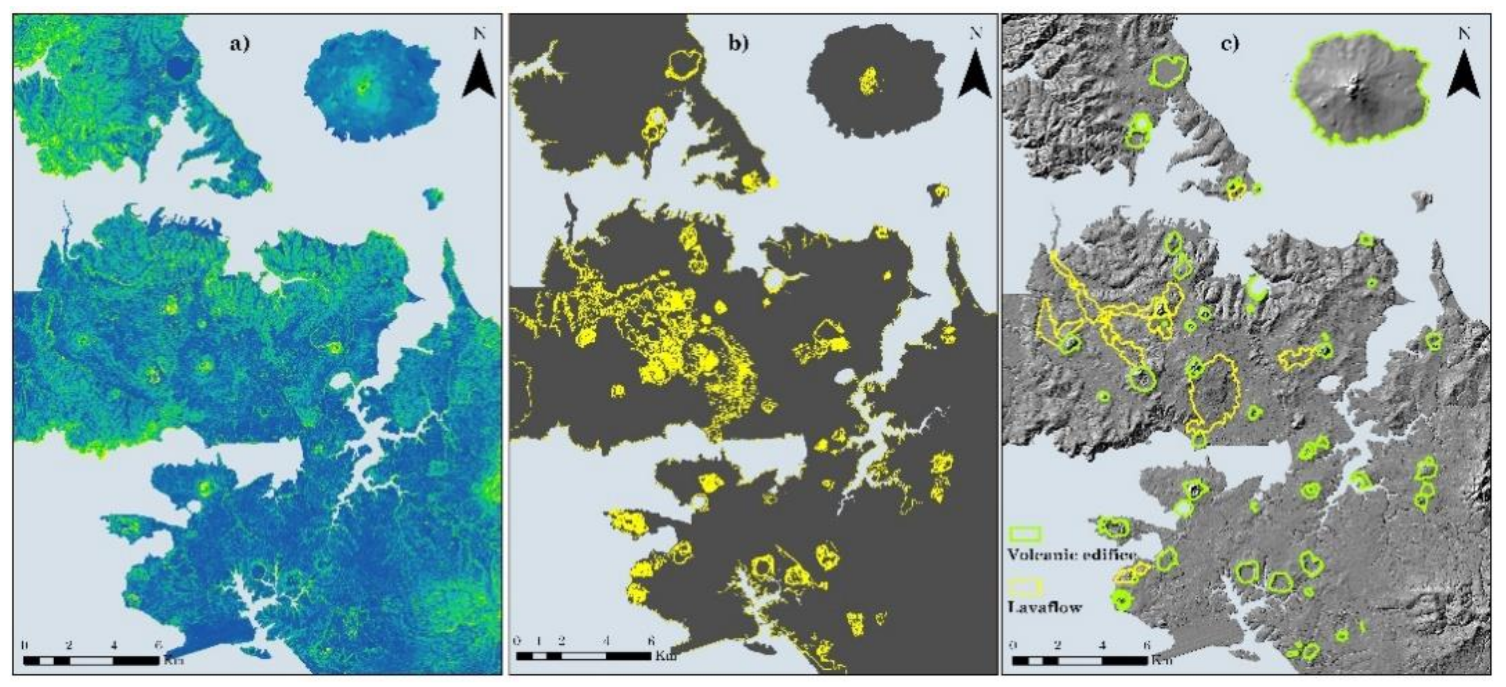
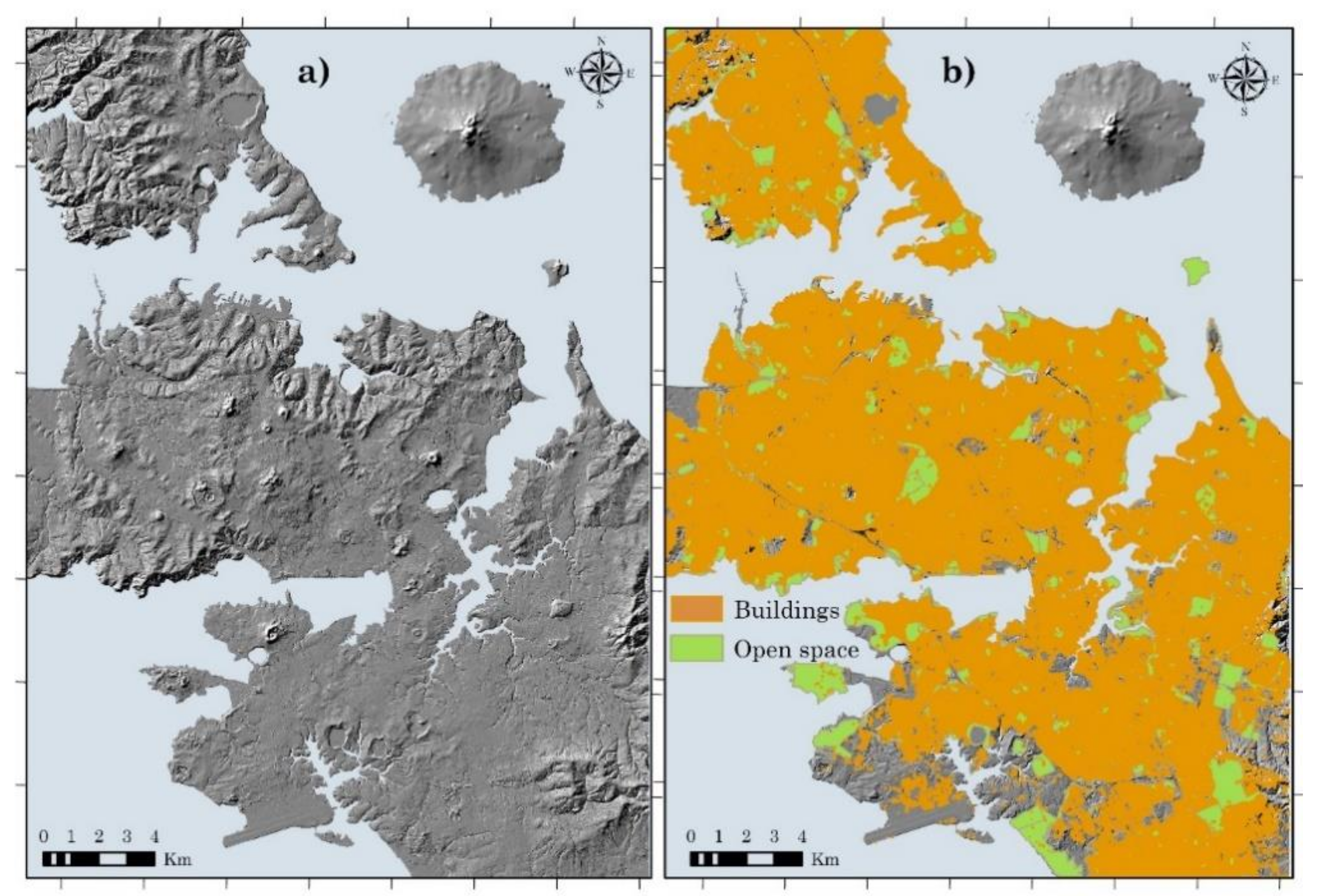
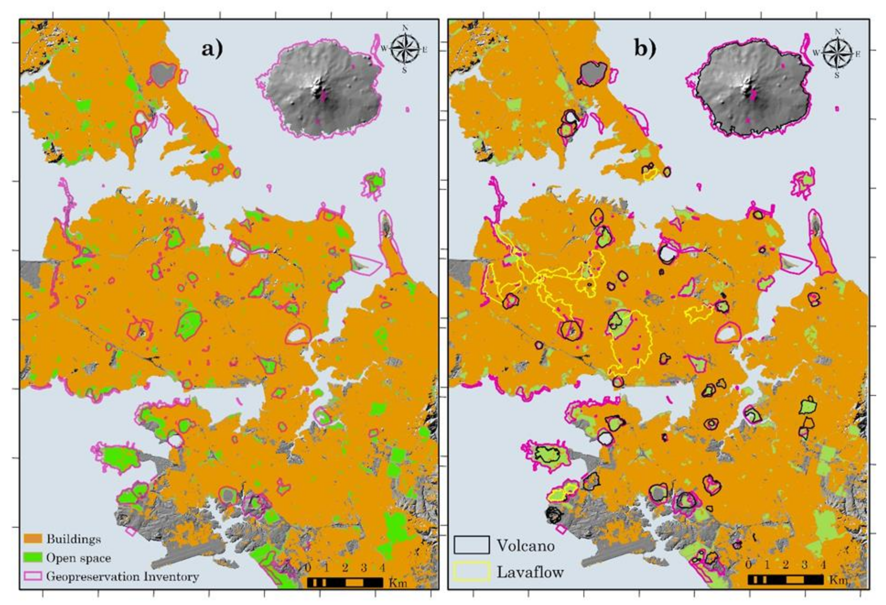
4.2.1. Boundary
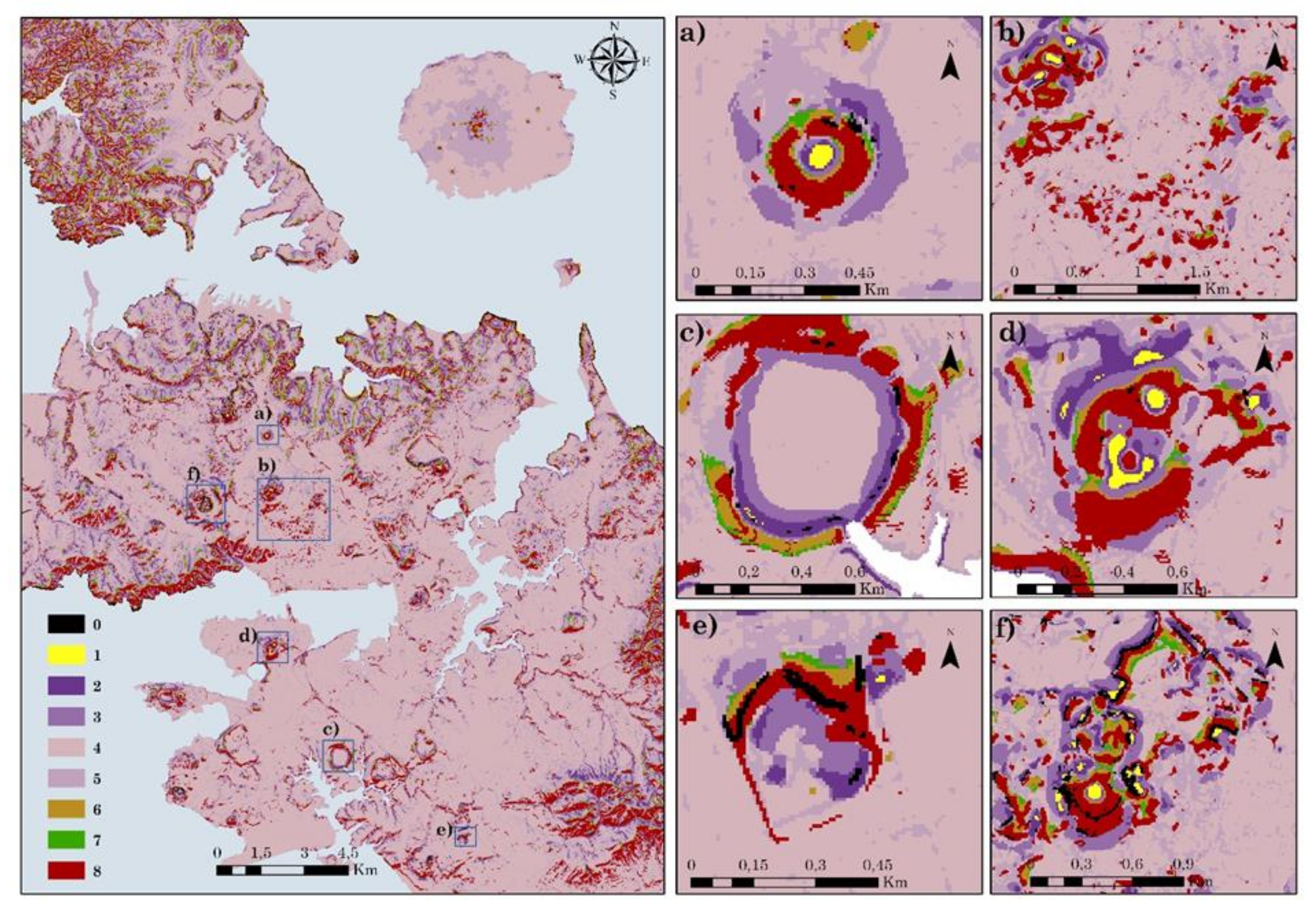
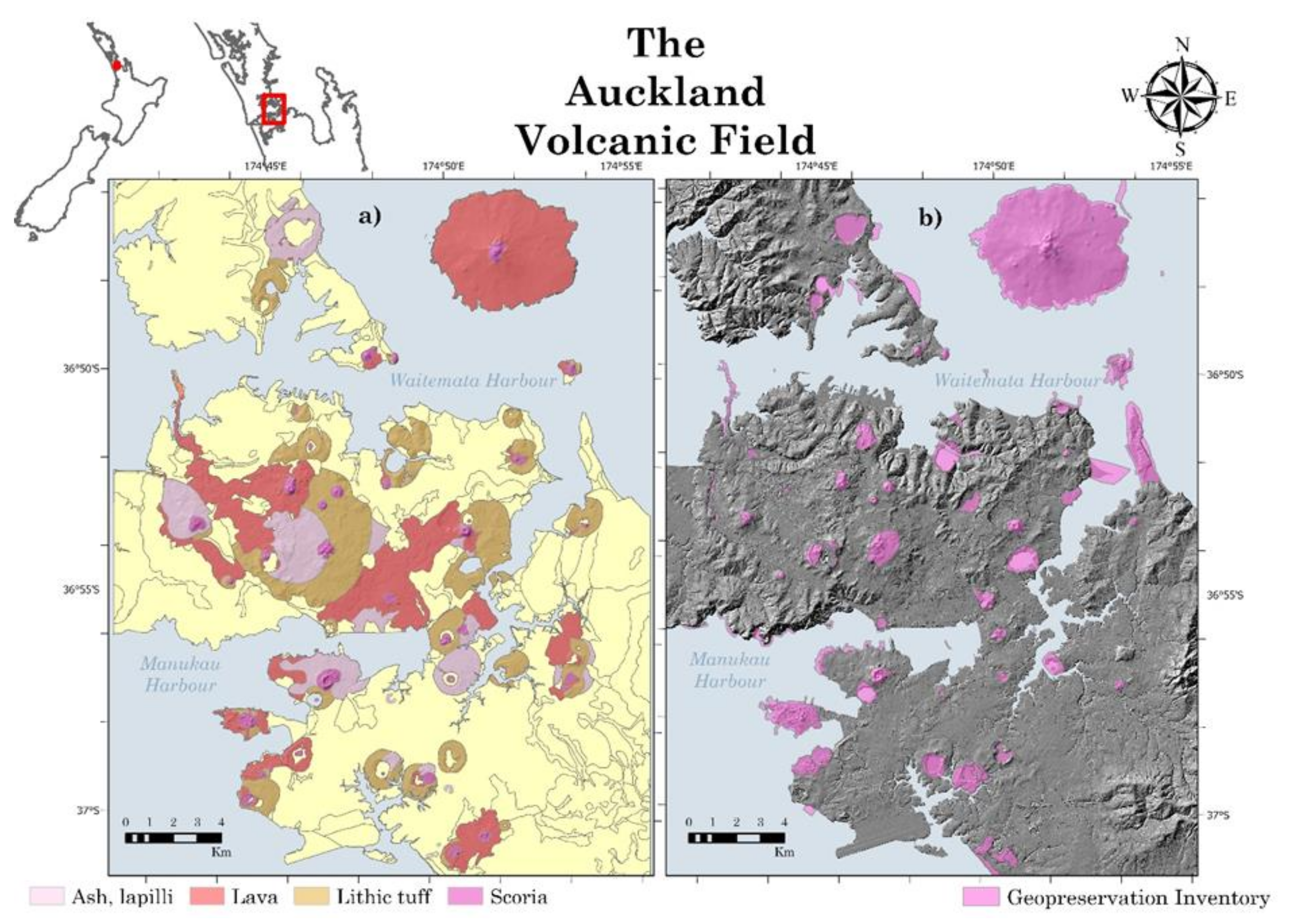
4.2.2. Classification
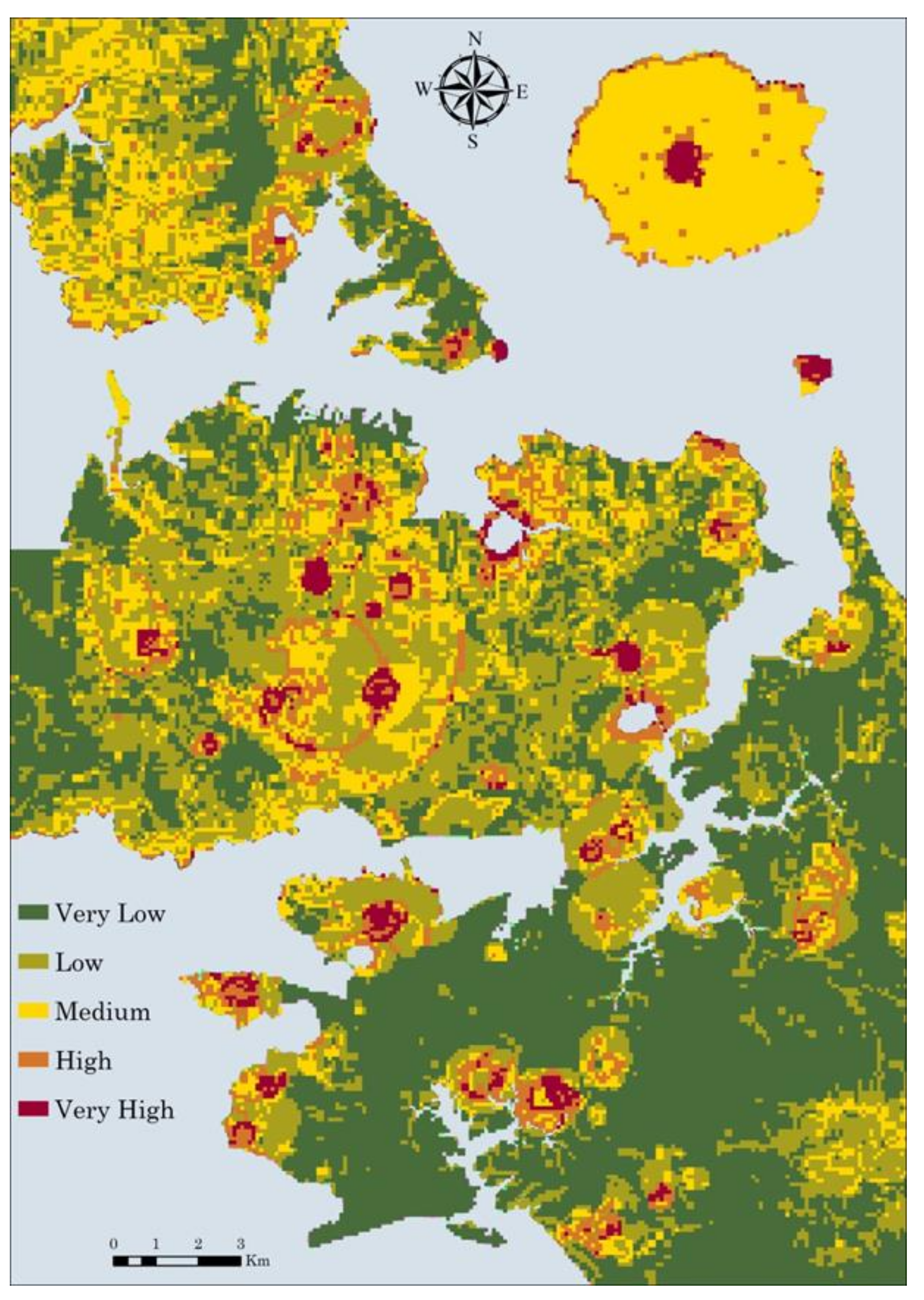
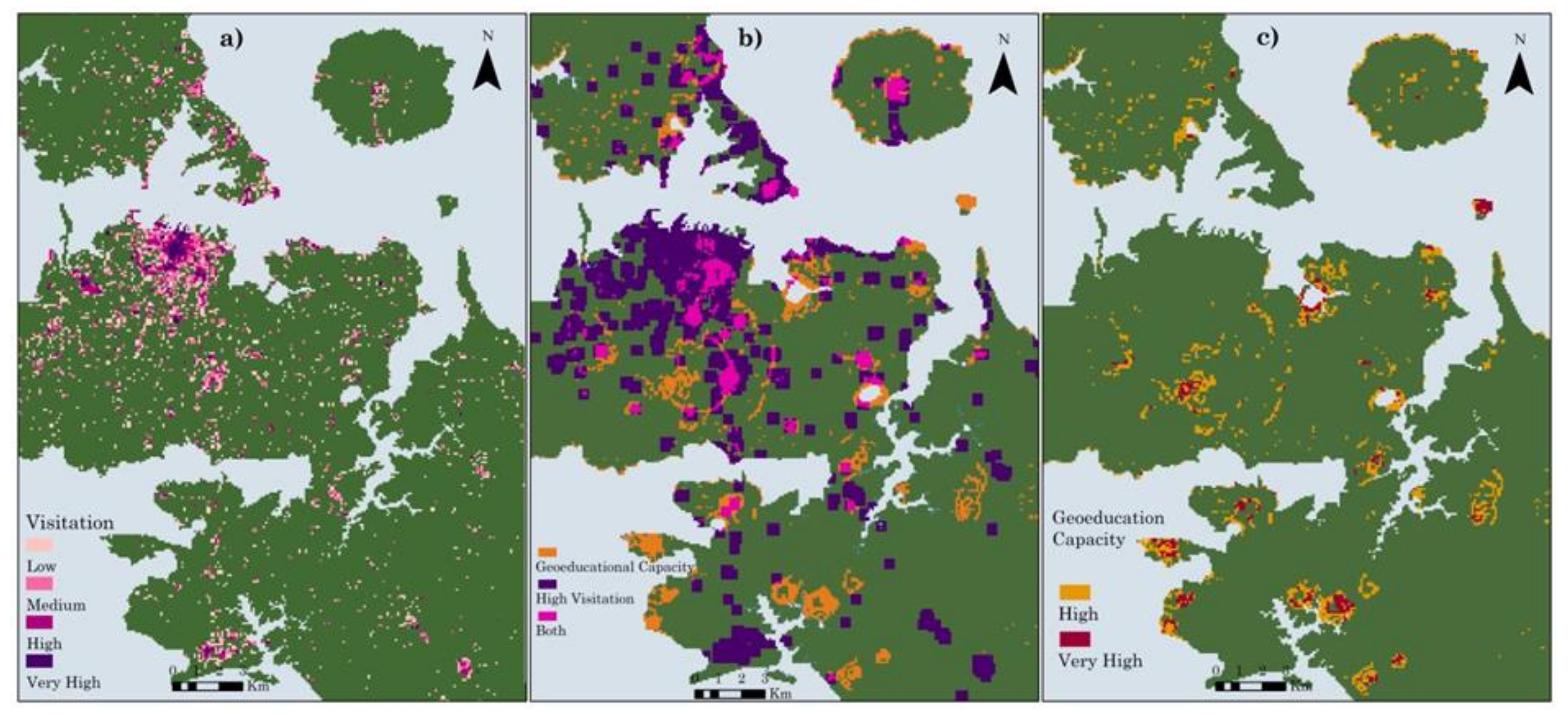
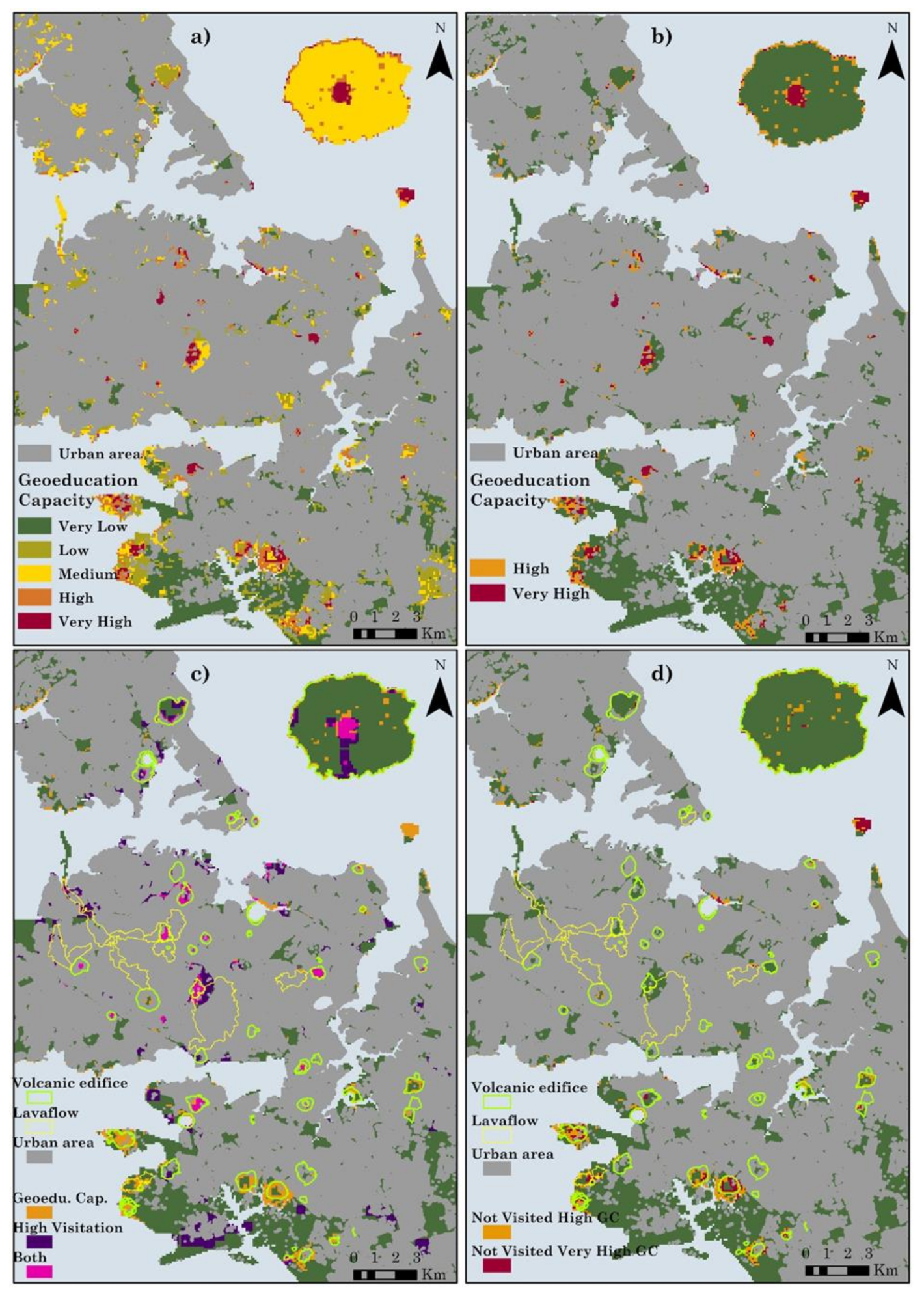
4.2.3. Analysis
5. Discussion
5.1. GIS Techniques to Strengthen Geoheritage Case
5.2. Geoeducational Capacity Map in Urban Planning
5.3. Geoeducational Capacity Map in Indigenous Knowledge System
5.4. Improving Geoeducational Site Network in Auckland
5.5. Big Data Analysis as Decision Making Support Tool
6. Conclusions
Author Contributions
Funding
Data Availability Statement
Acknowledgments
Conflicts of Interest
References
- Jiao, L. Urban land density function: A new method to characterize urban expansion. Landsc. Urban Plan 2015, 139, 26–39. [Google Scholar] [CrossRef]
- Auckland Governance Reforms. Spatial Planning Options for the Auckland Council. Cabinet Comittee on Implementation of Auckland Governance Reforms, Ministry for the Environment, New Zealand Government. 2009.
- Gu, K. Urban morphological regions and urban landscape management: The case of central Auckland, New Zealand. Urban Des. Int. 2010, 15, 148–164. [Google Scholar] [CrossRef]
- UNEP. Decoupling Natural Resource Use and Environmental Impacts from Economic Growth; Fischer-Kowalski, M., Swilling, M., von Weizsäcker, E.U., Ren, Y., Moriguchi, Y., Crane, W., Krausmann, F., Eisenmenger, N., Giljum, S., Hennicke, P., et al., Eds.; A Report of the Working Group on Decoupling to the International Resource Panel; United Nations Environment Programme: Nairobi, Kenya, 2011; Volume 2011. [Google Scholar]
- Pongsiri, M.J.; Roman, J.; Ezenwa, V.O.; Goldberg, T.L.; Koren, H.S.; Newbold, S.C.; Ostfeld, R.S.; Pattanayak, S.K.; Salkeld, D.J. Biodiversity loss affects global disease ecology. Bioscience 2009, 59, 945–954. [Google Scholar] [CrossRef]
- Brooks, T.M.; Mittermeier, R.A.; Mittermeier, C.G.; Da Fonseca, G.A.; Rylands, A.B.; Konstant, W.R.; Flick, P.; Pilgrim, J.; Oldfield, S.; Magin, G. Habitat loss and extinction in the hotspots of biodiversity. Conserv. Biol. 2002, 16, 909–923. [Google Scholar] [CrossRef] [Green Version]
- Hoekstra, J.M.; Boucher, T.M.; Ricketts, T.H.; Roberts, C. Confronting a biome crisis: Global disparities of habitat loss and protection. Ecol. Lett. 2005, 8, 23–29. [Google Scholar] [CrossRef]
- UNEP-WCMC. Mapping Multilateral Environmental Agreements to the Aichi Biodiversity Targets. 2015. Available online: https://www.unep.org/resources/report/mapping-multilateral-environmental-agreements-aichi-biodiversity-targets (accessed on 20 September 2021).
- Di Capua, G.; Bobrowsky, P.T.; Kieffer, S.W.; Palinkas, C. Introduction: Geoethics goes beyond the geoscience profession. Geol. Soc. Lond. Spec. Publ. 2021, 508, 1. [Google Scholar] [CrossRef]
- Ruban, D.A.; Tiess, G.; Sallam, E.S.; Ponedelnik, A.A.; Yashalova, N.N. Combined mineral and geoheritage resources related to kaolin, phosphate, and cement production in Egypt: Conceptualization, assessment, and policy implications. Sustain. Environ. Res. 2018, 28, 454–461. [Google Scholar] [CrossRef]
- Gray, M. Valuing Geodiversity in an ‘Ecosystem Services’ Context. Scott. Geogr. J. 2012, 128, 177–194. [Google Scholar] [CrossRef]
- Fox, N.; Graham, L.J.; Eigenbrod, F.; Bullock, J.M.; Parks, K.E. Incorporating geodiversity in ecosystem service decisions. Ecosyst. People 2020, 16, 151–159. [Google Scholar] [CrossRef]
- van Ree, C.C.D.F.; van Beukering, P.J.H.; Boekestijn, J. Geosystem services: A hidden link in ecosystem management. Ecosyst. Serv. 2017, 26, 58–69. [Google Scholar] [CrossRef]
- Gray, M. Other nature: Geodiversity and geosystem services. Environ. Conserv. 2011, 38, 271–274. [Google Scholar] [CrossRef] [Green Version]
- Németh, K.; Gravis, I.; Németh, B. Dilemma of Geoconservation of Monogenetic Volcanic Sites under Fast Urbanization and Infrastructure Developments with Special Relevance to the Auckland Volcanic Field, New Zealand. Sustainability 2021, 13, 6549. [Google Scholar] [CrossRef]
- Justus, J.; Colyvan, M.; Regan, H.; Maguire, L. Buying into conservation: Intrinsic versus instrumental value. Trends Ecol. Evol. 2009, 24, 187–191. [Google Scholar] [CrossRef] [PubMed] [Green Version]
- Fick, G.R.; Brent Ritchie, J.R. Measuring Service Quality in the Travel and Tourism Industry. J. Travel Res. 1991, 30, 2–9. [Google Scholar] [CrossRef]
- Hassan, S.S. Determinants of market competitiveness in an environmentally sustainable tourism industry. J. Travel Res. 2000, 38, 239–245. [Google Scholar] [CrossRef]
- Leiper, N. Why ‘the tourism industry’is misleading as a generic expression: The case for the plural variation,‘tourism industries’. Tour. Manag. 2008, 29, 237–251. [Google Scholar] [CrossRef]
- Moreira, J.C.; Vale, T.F.d.; Burns, R.C. Fernando de Noronha Archipelago (Brazil): A Coastal Geopark Proposal to Foster the Local Economy, Tourism and Sustainability. Water 2021, 13, 1586. [Google Scholar] [CrossRef]
- Štrba, Ľ.; Kolačkovská, J.; Kudelas, D.; Kršák, B.; Sidor, C. Geoheritage and Geotourism Contribution to Tourism Development in Protected Areas of Slovakia—Theoretical Considerations. Sustainability 2020, 12, 2979. [Google Scholar] [CrossRef] [Green Version]
- Duarte, A.; Braga, V.; Marques, C.; Sá, A.A. Geotourism and Territorial Development: A Systematic Literature Review and Research Agenda. Geoheritage 2020, 12, 65. [Google Scholar] [CrossRef]
- Beretic, N.; Đukanović, Z.; Cecchini, A. Geotourism as a Development Tool of the Geo-mining Park in Sardinia. Geoheritage 2019, 11, 1–16. [Google Scholar] [CrossRef]
- Lim, K. A Study of Geotourism Growth through Recognition of Geoeducation and Geoconservation for the Geoheritage. J. Tour. Leis Res. 2014, 26, 43–59. [Google Scholar]
- Gordon, J.E.; Barron, H.F. Valuing Geodiversity and Geoconservation: Developing a More Strategic Ecosystem Approach. Scott. Geogr. J. 2012, 128, 278–297. [Google Scholar] [CrossRef]
- Pringle, J.K. Educational egaming: The future for geoscience virtual learners? Geol. Today 2014, 30, 147–150. [Google Scholar] [CrossRef] [Green Version]
- Lukes, L.A.; Jones, J.P.; McConnell, D.A. Self-regulated learning: Overview and potential future directions in geoscience. J. Geosci. Educ. 2021, 69, 14–26. [Google Scholar] [CrossRef]
- Elliott, S.M.; Hanson, H.P. Syndication of the earth system: The future of geoscience? Environ. Sci. Policy 2003, 6, 457–463. [Google Scholar] [CrossRef]
- Manduca, C.; Kastens, K. Geoscience and geoscientists: Uniquely equipped to study Earth. Spec. Pap. Geol. Soc. Am. 2012, 486, 1–12. [Google Scholar] [CrossRef] [Green Version]
- Leiper, N. Tourist attraction systems. Ann. Tour. Res. 1990, 17, 367–384. [Google Scholar] [CrossRef]
- Yeung, S.K. An Evaluation of the Hong Kong Geopark: To What Extent Does It Promote Sustainable Human Development? Master’s Thesis, Lund University, Lund, Sweden, June 2013. [Google Scholar]
- Wang, L.; Tian, M.; Wang, L. Geodiversity, geoconservation and geotourism in Hong Kong Global Geopark of China. Proc. Geol. Assoc. 2015, 126, 426–437. [Google Scholar] [CrossRef]
- Ng, S.L. Hong Kong Geopark: A paradigm of urban sustainable tourism. Asian Geogr. 2014, 31, 83–96. [Google Scholar] [CrossRef]
- Sütő, L.; Ésik, Z.; Nagy, R.; Homoki, E.; Novák, T.J.; Szepesi, J. Promoting Geoheritage Through a Field Based Geo-education Event, a Case Study of the Hungarian Geotope Day in the Bükk Region Geopark. Geoconserv. Res. 2020, 3, 81–96. [Google Scholar]
- Henriques, M.H.; Tomaz, C.; Sá, A.A. The Arouca Geopark (Portugal) as an educational resource: A case study. Episodes 2012, 35, 481–488. [Google Scholar] [CrossRef] [PubMed] [Green Version]
- Rodrigues, J.; Neto de Carvalho, C.; Ramos, M.; Ramos, R.; Vinagre, A.; Vinagre, H. Geoproducts–Innovative development strategies in UNESCO Geoparks: Concept, implementation methodology, and case studies from Naturtejo Global Geopark, Portugal. Int. J. Geoherit. Parks 2021, 9, 108–128. [Google Scholar] [CrossRef]
- Yeoman, I.; Brass, D.; McMahon-Beattie, U. Current issue in tourism: The authentic tourist. Tour. Manag. 2007, 28, 1128–1138. [Google Scholar] [CrossRef]
- Cohen, E. Authenticity, equity and sustainability in tourism. J. Sustain. Tour. 2002, 10, 267–276. [Google Scholar] [CrossRef]
- Maslow, A.H. Toward a Psychology of Being; Simon and Schuster: New York, NY, USA, 2013. [Google Scholar]
- Andrasanu, A. Buzau land geopark. Steps in building a new geopark in Romania. In Proceedings of the XIX CBGA Congress, Thessaloniki, Greece, 23–26 September 2010; pp. 503–512. [Google Scholar]
- Tomić, N. The potential of Lazar Canyon (Serbia) as a geotourism destination: Inventory and evaluation. Geogr. Pannonica 2011, 15, 103–112. [Google Scholar] [CrossRef]
- Liberatoscioli, E.; Boscaino, G.; Agostini, S.; Garzarella, A.; Patacca Scandone, E. The Majella National Park: An Aspiring UNESCO Geopark. Geosciences 2018, 8, 256. [Google Scholar] [CrossRef] [Green Version]
- AlRayyan, K.; Hamarneh, C.; Sukkar, H.; Ghaith, A.; Abu-Jaber, N. From Abandoned Mines to a Labyrinth of Knowledge: A Conceptual Design for a Geoheritage Park Museum in Jordan. Geoheritage 2019, 11, 257–270. [Google Scholar] [CrossRef]
- Caironi, V.; Zucali, M.; Bollati, I.; Gomba, T.; San Martino, A.; Fumagalli, P. Urban Geology: Itineraries in the city center to discover lithological geodiversity. Rend. Online Soc. Geol. Ital. 2019, 49, 26–32. [Google Scholar]
- Comentale, B. Disused stone quarries in urban landscape, a feature of geoheritage: Case studies from Paris and Nantes. Physio-Geo 2019, 13, 1–24. [Google Scholar] [CrossRef]
- Habibi, T.; Ponedelnik, A.A.; Yashalova, N.N.; Ruban, D.A. Urban geoheritage complexity: Evidence of a unique natural resource from Shiraz city in Iran. Resour. Policy 2018, 59, 85–94. [Google Scholar] [CrossRef]
- Pelfini, M.; Bollati, I.M.; Giudici, M.; Pedrazzini, T.; Sturani, M.; Zucali, M. Urban geoheritage as a resource for Earth Sciences education: Examples from Milan metropolitan area. Rend. Online Della Soc. Geol. Ital. 2018, 45, 83–88. [Google Scholar] [CrossRef]
- Polck, M.A.d.R.; de Medeiros, M.A.M.; de Araújo-Júnior, H.I. Geodiversity in Urban Cultural Spaces of Rio de Janeiro City: Revealing the Geoscientific Knowledge with Emphasis on the Fossil Content. Geoheritage 2020, 12, 47. [Google Scholar] [CrossRef]
- Portal, C.; Kerguillec, R. The Shape of a City: Geomorphological Landscapes, Abiotic Urban Environment, and Geoheritage in the Western World: The Example of Parks and Gardens. Geoheritage 2018, 10, 67–78. [Google Scholar] [CrossRef]
- Wolniewicz, P. Bringing the History of the Earth to the Public by Using Storytelling and Fossils from Decorative Stones of the City of Poznań, Poland. Geoheritage 2019, 11, 1827–1837. [Google Scholar] [CrossRef] [Green Version]
- Capdevila-Werning, R. Preserving Destruction: Philosophical Issues of Urban Geosites. Open Philos. 2020, 3, 550–565. [Google Scholar] [CrossRef]
- Prosser, C.D. Geoconservation, Quarrying and Mining: Opportunities and Challenges Illustrated Through Working in Partnership with the Mineral Extraction Industry in England. Geoheritage 2018, 10, 259–270. [Google Scholar] [CrossRef]
- Gioncada, A.; Pitzalis, E.; Cioni, R.; Fulignati, P.; Lezzerini, M.; Mundula, F.; Funedda, A. the volcanic and mining geoheritage of San Pietro Island (Sulcis, Sardinia, Italy): The potential for geosite valorization. Geoheritage 2019, 11, 1567–1581. [Google Scholar] [CrossRef]
- López-García, J.A.; Oyarzun, R.; Andrés, S.L.; Martínez, J.I.M. Scientific, educational, and environmental considerations regarding mine sites and geoheritage: A perspective from SE Spain. Geoheritage 2011, 3, 267–275. [Google Scholar] [CrossRef] [Green Version]
- Hu, W.; Wall, G. Environmental management, environmental image and the competitive tourist attraction. J. Sustain. Tour. 2005, 13, 617–635. [Google Scholar] [CrossRef]
- Newsome, D.; Dowling, R.; Leung, Y.-F. The nature and management of geotourism: A case study of two established iconic geotourism destinations. Tour. Manag. Perspect. 2012, 2, 19–27. [Google Scholar] [CrossRef]
- Farsani, N.T.; Coelho, C.O.A.; Costa, C.M.M. Analysis of Network Activities in Geoparks as Geotourism Destinations. Int. J. Tour. Res. 2014, 16, 1–10. [Google Scholar] [CrossRef]
- Gatautis, R.; Vitkauskaite, E. Crowdsourcing application in marketing activities. Procedia-Soc. Behav. Sci. 2014, 110, 1243–1250. [Google Scholar] [CrossRef] [Green Version]
- Whitla, P. Crowdsourcing and its application in marketing activities. Contemp. Manag. Res. 2009, 5. [Google Scholar] [CrossRef]
- Brabham, D.C. Crowdsourcing the public participation process for planning projects. Plan. Theory 2009, 8, 242–262. [Google Scholar] [CrossRef]
- Certoma, C.; Corsini, F.; Rizzi, F. Crowdsourcing urban sustainability. Data, people and technologies in participatory governance. Futures 2015, 74, 93–106. [Google Scholar] [CrossRef]
- Sigala, M. Gamification for crowdsourcing marketing practices: Applications and benefits in tourism. Adv. Crowdsourcing 2015, 129–145. [Google Scholar]
- Lehdonvirta, V.; Bright, J. Crowdsourcing for public policy and government. Policy Internet 2015, 7, 263–267. [Google Scholar] [CrossRef] [Green Version]
- Prpić, J.; Taeihagh, A.; Melton, J. The fundamentals of policy crowdsourcing. Policy Internet 2015, 7, 340–361. [Google Scholar] [CrossRef] [Green Version]
- Brabham, D.C.; Ribisl, K.M.; Kirchner, T.R.; Bernhardt, J.M. Crowdsourcing applications for public health. Am. J. Prev. Med. 2014, 46, 179–187. [Google Scholar] [CrossRef]
- Good, B.M.; Su, A.I. Crowdsourcing for bioinformatics. Bioinformatics 2013, 29, 1925–1933. [Google Scholar] [CrossRef] [PubMed] [Green Version]
- Solemon, B.; Ariffin, I.; Din, M.M.; Anwar, R.M. A review of the uses of crowdsourcing in higher education. Int. J. Asian Soc. Sci. 2013, 3, 2066–2073. [Google Scholar]
- Besaleva, L.I.; Weaver, A.C. CrowdHelp: A crowdsourcing application for improving disaster management. In Proceedings of the 2013 IEEE Global Humanitarian Technology Conference (GHTC), San Jose, CA, USA, 20–23 October 2013; pp. 185–190. [Google Scholar]
- Djelassi, S.; Decoopman, I. Customers’ participation in product development through crowdsourcing: Issues and implications. Ind. Mark. Manag. 2013, 42, 683–692. [Google Scholar] [CrossRef]
- Alivand, M.; Hochmair, H.H. Spatiotemporal analysis of photo contribution patterns to Panoramio and Flickr. Cartogr. Geogr. Inf. Sci. 2017, 44, 170–184. [Google Scholar] [CrossRef]
- Zielstra, D.; Hochmair, H.H. Positional accuracy analysis of Flickr and Panoramio images for selected world regions. J. Spat. Sci. 2013, 58, 251–273. [Google Scholar] [CrossRef]
- Shafique, S.; Ali, M.E. Recommending most popular travel path within a region of interest from historical trajectory data. In Proceedings of the 5th ACM SIGSPATIAL International Workshop on Mobile Geographic Information Systems, Burlingame, CA, USA, 31 October 2016; pp. 2–11. [Google Scholar]
- Cai, G.; Hio, C.; Bermingham, L.; Lee, K.; Lee, I. Mining frequent trajectory patterns and regions-of-interest from Flickr photos. In Proceedings of the 2014 47th Hawaii International Conference on System Sciences, Waikoloa, HI, USA, 6–9 January 2014; pp. 1454–1463. [Google Scholar]
- Höpken, W.; Müller, M.; Fuchs, M.; Lexhagen, M. Flickr data for analysing tourists’ spatial behaviour and movement patterns: A comparison of clustering techniques. J. Hosp. Tour. Technol. 2020. Available online: https://www.emerald.com/insight/content/doi/10.1108/JHTT-08-2017-0059/full/html (accessed on 20 September 2021).
- Kisilevich, S.; Krstajic, M.; Keim, D.; Andrienko, N.; Andrienko, G. Event-based analysis of people’s activities and behavior using flickr and panoramio geotagged photo collections. In Proceedings of the 2010 14th International Conference Information Visualisation, London, UK, 26–29 July 2010; pp. 289–296. [Google Scholar]
- Kádár, B.; Gede, M. Where Do Tourists Go? Visualizing and Analysing the Spatial Distribution of Geotagged Photography. Cartogr. Int. J. Geogr. Inf. Geovisualization 2013, 48, 78–88. [Google Scholar] [CrossRef]
- Chareyron, G.; Da-Rugna, J.; Branchet, B. Mining tourist routes using flickr traces. In Proceedings of the 2013 IEEE/ACM International Conference on Advances in Social Networks Analysis and Mining, Niagara, ON, Canada, 25–28 August 2013; pp. 1488–1489. [Google Scholar]
- Chen, L.; Roy, A. Event detection from flickr data through wavelet-based spatial analysis. In Proceedings of the 18th ACM Conference on Information and Knowledge Management, Hong Kong, China, 6–9 November 2009; pp. 523–532. [Google Scholar]
- Weiss, A.D. Topographic Position and Landforms Analysis. 2001. Available online: http://www.jennessent.com/downloads/tpi-poster-tnc_18x22.pdf (accessed on 16 August 2021).
- Theobald, D.M.; Harrison-Atlas, D.; Monahan, W.B.; Albano, C.M. Ecologically-Relevant Maps of Landforms and Physiographic Diversity for Climate Adaptation Planning. PLoS ONE 2015, 10, e0143619. [Google Scholar] [CrossRef] [Green Version]
- Woo, C.-S.; Lee, C.-W.; Jeong, Y. Study on application of topographic position index for prediction of the landslide occurrence. J. Korean Soc. Environ. Restor. Technol. 2008, 11, 1–9. [Google Scholar]
- Riley, J.W.; Calhoun, D.L.; Barichivich, W.J.; Walls, S.C. Identifying small depressional wetlands and using a topographic position index to infer hydroperiod regimes for pond-breeding amphibians. Wetlands 2017, 37, 325–338. [Google Scholar] [CrossRef]
- Ma, J.; Lin, G.; Chen, J.; Yang, L. An improved topographic wetness index considering topographic position. In Proceedings of the 2010 18th International Conference on Geoinformatics, Beijing, China, 18–20 June 2010; pp. 1–4. [Google Scholar]
- Mieza, M.S.; Cravero, W.R.; Kovac, F.D.; Bargiano, P.G. Delineation of site-specific management units for operational applications using the topographic position index in La Pampa, Argentina. Comput. Electron. Agric. 2016, 127, 158–167. [Google Scholar] [CrossRef] [Green Version]
- Trentin, R.; de Souza Robaina, L.E. Study of the landforms of the ibicuí river basin with use of topographic position index. Rev. Bras. De Geomorfol. 2018, 19. [Google Scholar] [CrossRef] [Green Version]
- Skentos, A. Topographic Position Index based landform analysis of Messaria (Ikaria Island, Greece). Acta Geobalcanica 2018, 4, 7–15. [Google Scholar] [CrossRef]
- Hopkins, J.L.; Smid, E.R.; Eccles, J.D.; Hayes, J.L.; Hayward, B.W.; McGee, L.E.; van Wijk, K.; Wilson, T.M.; Cronin, S.J.; Leonard, G.S.; et al. Auckland Volcanic Field magmatism, volcanism, and hazard: A review. New Zealand J. Geol. Geophys. 2020, 64, 1–22. [Google Scholar] [CrossRef]
- Demographia. Demographia International Housing Affordability. 2021. Available online: http://www.demographia.com/dhi.pdf (accessed on 1 August 2021).
- Wetzstein, S. Comparative housing, urban crisis and political economy: An ethnographically based ‘long view’ from Auckland, Singapore and Berlin. Hous. Stud. 2019, 34, 272–297. [Google Scholar] [CrossRef]
- Hayes, J.L.; Wilson, T.M.; Deligne, N.I.; Lindsay, J.M.; Leonard, G.S.; Tsang, S.W.R.; Fitzgerald, R.H. Developing a suite of multi-hazard volcanic eruption scenarios using an interdisciplinary approach. J. Volcanol. Geotherm. Res. 2020, 392, 106763. [Google Scholar] [CrossRef]
- Deligne, N.I.; Fitzgerald, R.H.; Blake, D.M.; Davies, A.J.; Hayes, J.L.; Stewart, C.; Wilson, G.; Wilson, T.M.; Castelino, R.; Kennedy, B.M.; et al. Investigating the consequences of urban volcanism using a scenario approach I: Development and application of a hypothetical eruption in the Auckland Volcanic Field, New Zealand. J. Volcanol. Geotherm. Res. 2017, 336, 192–208. [Google Scholar] [CrossRef]
- Kereszturi, G.; Bebbington, M.; Nemeth, K. Forecasting transitions in monogenetic eruptions using the geologic record. Geology 2017, 45, 283–286. [Google Scholar] [CrossRef]
- Linnell, T.; Shane, P.; Smith, I.; Augustinus, P.; Cronin, S.; Lindsay, J.; Maas, R. Long-lived shield volcanism within a monogenetic basaltic field: The conundrum of Rangitoto volcano, New Zealand. GSA Bull. 2016, 128, 1160–1172. [Google Scholar] [CrossRef]
- Agustín-Flores, J.; Németh, K.; Cronin, S.J.; Lindsay, J.M.; Kereszturi, G. Shallow-seated explosions in the construction of the Motukorea tuff ring (Auckland, New Zealand): Evidence from lithic and sedimentary characteristics. J. Volcanol. Geotherm. Res. 2015, 304, 272–286. [Google Scholar] [CrossRef]
- Hayward, B.W. Volcanoes of Auckland: A Field Guide; Auckland University Press: Auckland, New Zealand, 2019; p. 335. [Google Scholar]
- Pressey, R.L.; Weeks, R.; Gurney, G.G. From displacement activities to evidence-informed decisions in conservation. Biol. Conserv. 2017, 212, 337–348. [Google Scholar] [CrossRef]
- Destination AKL 2025. A New Direction for Auckland’s Visitor Economy. Auckland Tourism, Events and Economic Development. 2018. Available online: https://www.aucklandnz.com/destinationakl (accessed on 1 May 2021).
- Németh, B.; Németh, K.; Procter, J.N.; Farrelly, T. Geoheritage Conservation: Systematic Mapping Study for Conceptual Synthesis. Geoheritage 2021, 13, 45. [Google Scholar] [CrossRef]
- Auckland Conservation Management Strategy. In Auckland Conservation Management Strategy (CMS) 2014–2020; Auckland City Council: Auckland, New Zealand, 2014; Volume I.
- New Zealand-Aotearoa Government Tourism Strategy. Enrich New Zealand-Aotearoa through Sustainable Tourism Growth. Department of Conservation, Ministry of Business, Innovation and Employment, New Zealand Government, 2019. Available online: https://www.mbie.govt.nz/dmsdocument/5482-2019-new-zealand-aotearoa-government-tourism-strategy-pdf (accessed on 1 June 2020).
- New Zealand Coastal Policy Statement. Replaces New Zealand Coastal Policy Statement 1994; New Zealand Department of Conservation: Wellington, New Zealand, 2010.
- New Zealand Geopreservation Inventory. Available online: https://services.main.net.nz/geopreservation/. (accessed on 31 August 2020).
- The Auckland Plan. The Aucklan Plan 2050. 2018. Available online: https://www.aucklandcouncil.govt.nz/plans-projects-policies-reports-bylaws/our-plans-strategies/auckland-plan/Pages/default.aspx (accessed on 31 August 2020).
- Wright, J. The State of New Zealand’s Environment: Commentary by the Parliamentary Commissioner for the Environment on Environment Aotearoa 2015, June 2016; Parliamentary Commissioner for the Environment, Te Kaittiaki Taiao a Te Whare Paremata. 2016. Available online: https://www.pce.parliament.nz/publications/the-state-of-new-zealands-environment-commentary-by-the-parliamentary-commissioner-for-the-environment-on-environment-aotearoa-2015 (accessed on 31 August 2020).
- Auckland Council. Open Space Provision Policy 2016. 2016. Available online: https://www.aucklandcouncil.govt.nz/plans-projects-policies-reports-bylaws/our-policies/Documents/open-space-provision-policy.pdf (accessed on 1 May 2021).
- Auckland Regional Council. Auckland Regional Policy Statement. 1999. Available online: http://www.aucklandcity.govt.nz/council/documents/regionalplans/aucklandcouncilregionalpolicystatement/ACRPS%20Policy.pdf (accessed on 1 May 2021).
- McCoy, M.D.; Ladefoged, T.N. In Pursuit of Māori Warfare: New archaeological research on conflict in pre-European contact New Zealand. J. Anthropol. Archaeol. 2019, 56, 101113. [Google Scholar] [CrossRef]
- Boswijk, G.; Johns, D. Assessing the potential to calendar date Māori waka (canoes) using dendrochronology. J. Archaeol. Sci. Rep. 2018, 17, 442–448. [Google Scholar] [CrossRef]
- Pool, I. Te Iwi Maori: Population Past, Present and Projected; Auckland University Press: Auckland, New Zealand, 2013. [Google Scholar]
- Ryks, J.; Pearson, A.L.; Waa, A. Mapping urban Māori: A population-based study of Māori heterogeneity. N. Z. Geogr. 2016, 72, 28–40. [Google Scholar] [CrossRef] [Green Version]
- Stone, R.C.J. From Tamaki-Makau-Rau to Auckland: A History of Auckland; Auckland University Press: Auckland, New Zealand, 2001. [Google Scholar]
- Németh, K.; Moufti, M.R. Geoheritage Values of a Mature Monogenetic Volcanic Field in Intra-continental Settings: Harrat Khaybar, Kingdom of Saudi Arabia. Geoheritage 2017, 9, 311–328. [Google Scholar] [CrossRef]
- Wimbledon, W. Geosites—A Mechanism for Protection, Integrating National and International Valuation Of Heritage Sites. In Proceedings of the Atti del Convegno nazionale “il Patrimonio geologico: Una risorsa da Proteggere e valorizzare” Periodico della SIGEA, Società Italiana di Geologia Ambientale, Basliicata, Italy, 29–30 April 2010; p. 492. [Google Scholar]
- Ruban, D.A. Comment on “Geotourist values of loess geoheritage within the planned Geopark Małopolska Vistula River Gap, Poland” by J. Warowna et al. [Quaternary International, 399, 46–57]. Quat. Int. 2016, 425, 196–197. [Google Scholar] [CrossRef]
- Reynard, E.; Coratza, P.; Hobléa, F. Current Research on Geomorphosites. Geoheritage 2016, 8, 1–3. [Google Scholar] [CrossRef] [Green Version]
- Pelfini, M.; Bollati, I. Landforms and geomorphosites ongoing changes: Concpets and implications for geoheritage promotion. Quaest. Geograph. 2014, 33, 131. [Google Scholar] [CrossRef] [Green Version]
- Višnić, T.; Began, M. Evaluation of geoheritage models—analysis and its application on the loess profiles in Vojvodina region. Forum Geogr. 2016, XV, 97–108. [Google Scholar] [CrossRef]
- Pralong, J.-P. A method for assessing tourist potential and use of geomorphological sites. Géomorphosites Définition Évaluation Cartogr. 2005, 11, 189–196. [Google Scholar] [CrossRef]
- Pereira, P.; Pereira, D. Methodological Guidelines for Geomorphosite Assessment. 2010. Available online: http://repositorium.sdum.uminho.pt/handle/1822/45573 (accessed on 31 August 2021).
- Reynard, E.; Fontana, G.; Kozlik, L.; Scapozza, C. A method for Assessing “Scientific” and “Additional Values” of Geomorphosites. Geograph. Helvetica 2007, 62, 148–158. [Google Scholar] [CrossRef]
- Brilha, J. Inventory and Quantitative Assessment of Geosites and Geodiversity Sites: A Review. Geoheritage 2016, 8, 119–134. [Google Scholar] [CrossRef] [Green Version]
- Hopkins, J.L.; Timm, C.; Millet, M.-A.; Poirier, A.; Wilson, C.J.N.; Leonard, G.S. Os isotopic constraints on crustal contamination in Auckland Volcanic Field basalts, New Zealand. Chem. Geol. 2016, 439, 83–97. [Google Scholar] [CrossRef]
- Seebeck, H.; Nicol, A.; Giba, M.; Pettinga, J.; Walsh, J. Geometry of the subducting Pacific plate since 20 Ma, Hikurangi margin, New Zealand. J. Geol. Soc. 2014, 171, 131–143. [Google Scholar] [CrossRef]
- Briggs, R.M.; Okada, T.; Itaya, T.; Shibuya, H.; Smith, I.E.M. K-Ar ages, paleomagnetism, and geochemistry of the South Auckland volcanic field, North Island, New Zealand. N. Z. J. Geol. Geophys. 1994, 37, 143–153. [Google Scholar] [CrossRef] [Green Version]
- Briggs, R.M.; Itaya, T.; Lowe, D.J.; Keane, A.J. Ages of the Pliocene—Pleistocene Alexandra and Ngatutura Volcanics, western North Island, New Zealand, and some geological implications. N. Z. J. Geol. Geophys. 1989, 32, 417–427. [Google Scholar] [CrossRef] [Green Version]
- Newnham, R.; Lowe, D.J.; Gehrels, M.; Augustinus, P. Two-step human–environmental impact history for northern New Zealand linked to late-Holocene climate change. Holocene 2018, 28, 1093–1106. [Google Scholar] [CrossRef]
- Brothers, R.N.; Golson, J. Geological and archaeological interpretation of a section in Rangitoto ash on Motutapu island, Auckland. N. Z. J. Geol. Geophys. 1959, 2, 569–577. [Google Scholar] [CrossRef]
- Hayward, B.W.; Murdoch, G.; Maitland, G. Volcanoes of Auckland, The Essential Guide; Auckland University Press: Auckland, New Zealand, 2011. [Google Scholar]
- Kereszturi, G.; Németh, K.; Cronin, S.J.; Procter, J.; Agustín-Flores, J. Influences on the variability of eruption sequences and style transitions in the Auckland Volcanic Field, New Zealand. J. Volcanol. Geotherm. Res. 2014, 286, 101–115. [Google Scholar] [CrossRef]
- Agustín-Flores, J.; Nemeth, K.; Cronin, S.; Lindsay, J.; Kereszturi, G.; Brand, B.; Smith, I. Phreatomagmatic eruptions through unconsolidated coastal plain sequences, Maungataketake, Auckland Volcanic Field (New Zealand). J. Volcanol. Geotherm. Res. 2014, 276. [Google Scholar] [CrossRef]
- Németh, K.; Cronin, S.J.; Smith, I.E.M.; Agustin Flores, J. Amplified hazard of small-volume monogenetic eruptions due to environmental controls, Orakei Basin, Auckland Volcanic Field, New Zealand. Bull. Volcanol. 2012, 74, 2121–2137. [Google Scholar] [CrossRef]
- Leonard, G.S.; Calvert, A.T.; Hopkins, J.L.; Wilson, C.J.N.; Smid, E.R.; Lindsay, J.M.; Champion, D.E. High-precision 40Ar/39Ar dating of Quaternary basalts from Auckland Volcanic Field, New Zealand, with implications for eruption rates and paleomagnetic correlations. J. Volcanol. Geotherm. Res. 2017, 343, 60–74. [Google Scholar] [CrossRef]
- Allen, S.R.; Smith, I.E.M. Eruption styles and volcanic hazard in the Auckland volcanic field. Geosci. Rep. Shizuoka Univ. 1994, 20, 5–14. [Google Scholar]
- Cassidy, J.; Locke, C.A. The Auckland volcanic field, New Zealand: Geophysical evidence for structural and spatio-temporal relationships. J. Volcanol. Geotherm. Res. 2010, 195, 127–137. [Google Scholar] [CrossRef]
- Sandri, L.; Jolly, G.; Lindsay, J.; Howe, T.; Marzocchi, W. Combining long- and short-term probabilistic volcanic hazard assessment with cost-benefit analysis to support decision making in a volcanic crisis from the Auckland Volcanic Field, New Zealand. Bull. Volcanol. 2012, 74, 705–723. [Google Scholar] [CrossRef]
- Lindsay, J.; Marzocchi, W.; Jolly, G.; Constantinescu, R.; Selva, J.; Sandri, L. Towards real-time eruption forecasting in the Auckland Volcanic Field: Application of BET_EF during the New Zealand National Disaster Exercise ‘Ruaumoko’. Bull. Volcanol. 2010, 72, 185–204. [Google Scholar] [CrossRef]
- Kereszturi, G. Monogenetic Basaltic Volcanoes: Genetic Classification, Growth, Geomorphology and Degradation; IntechOpen: London, UK, 2012. [Google Scholar]
- Hayward, B. Small satellite explosion craters in the Auckland Volcanic Field. Geocene 2015, 13, 5–12. [Google Scholar]
- Sprung, P.; Schuth, S.; Münker, C.; Hoke, L. Intraplate volcanism in New Zealand: The role of fossil plume material and variable lithospheric properties. Contrib. Mineral. Petrol. 2007, 153, 669–687. [Google Scholar] [CrossRef]
- Gravis, I.; Németh, K.; Procter, J.N. The Role of Cultural and Indigenous Values in Geosite Evaluations on a Quaternary Monogenetic Volcanic Landscape at Ihumātao, Auckland Volcanic Field, New Zealand. Geoheritage 2017, 9, 373–393. [Google Scholar] [CrossRef]
- Gravis, I.; Németh, K.; Twemlow, C.; Németh, B. The Case for Community-Led Geoheritage and Geoconservation Ventures in Māngere, South Auckland, and Central Otago, New Zealand. Geoheritage 2020, 12, 19. [Google Scholar] [CrossRef]
- Nemeth, K.; Casadevall, T.; Moufti, M.R.; Martí, J. Volcanic Geoheritage. 2017. Available online: https://link.springer.com/article/10.1007/s12371-017-0257-9 (accessed on 21 October 2021).
- Gravis, I.; Németh, K. From Regional Geopark to a UNESCO Global Geopark: Community Initiative with Strong Scientific Support to Evaluate the Geoheritage and Cultural Values at Ihumātao, South Auckland. In Proceedings of the 6th International Maar Conference – Abstracts, Edited by Jiaqi Liu, Rijeka, Croatia, 30 July–3 August 2016; pp. 39–40. [Google Scholar]
- Procter, J.; Nemeth, K. Recognising indigenous peoples values and knowledge systems in Geoheritage: Case studies from New Zealand and the South Pacific. In Proceedings of the EGU General Assembly Conference Abstracts, Vienna, Austria, 23–28 April 2017; p. 10979. [Google Scholar]
- Hayward, B.W.; Murdoch, G.; Maitland, G. Human Interaction with Auckland’s Volcanoes; University of Auckland Press: Auckland, New Zealand, 2011. [Google Scholar]
- Resource Management Act. Resource Management Act No 69 (as at 29 October 2019), Public Act—New Zealand Legislation. 1991. Available online: https://www.legislation.govt.nz/act/public/1991/0069/latest/DLM230265.html (accessed on 12 October 2020).
- Reserves Act. Reserves Act 1977 (Reprint as at 7 August 2020 New Zealand Legislation. 1977. Available online: https://www.legislation.govt.nz/act/public/1977/0066/latest/DLM444617.html?search=sw_096be8ed81a057c2_scientific_25_se&p=1&sr=11 (accessed on 1 June 2021).
- Kermode, L.; Heron, D.W. Geology of the Auckland Urban Area: Sheet R11: 1:50 000; GNS Science: Lower Hutt, New Zealand, 1992. [Google Scholar]
- Goodchild, M.F. Citizens as sensors: The world of volunteered geography. GeoJournal 2007, 69, 211–221. [Google Scholar] [CrossRef] [Green Version]
- Chen, J.; Shaw, S.-L. Representing the spatial extent of places based on flickr photos with a representativeness-weighted kernel density estimation. In Proceedings of the the Annual International Conference on Geographic Information Science, Montreal, QC, Canada, 27–30 September 2016; pp. 130–144. [Google Scholar]
- Sun, A.; Bhowmick, S.S. Quantifying tag representativeness of visual content of social images. In Proceedings of the 18th ACM international conference on Multimedia, Firenze, Italy, 25—29 October 2010; pp. 471–480. [Google Scholar]
- Lieskovský, J.; Rusňák, T.; Klimantová, A.; Izsóff, M.; Gašparovičová, P. Appreciation of landscape aesthetic values in Slovakia assessed by social media photographs. Open Geosci. 2017, 9, 593. [Google Scholar] [CrossRef] [Green Version]
- Huiskes, M.J.; Lew, M.S. The mir flickr retrieval evaluation. In Proceedings of the 1st ACM International Conference on Multimedia Information Retrieval, Vancouver, BC, Canada, 30–31 October 2008; pp. 39–43. [Google Scholar]
- Senaratne, H.; Bröring, A.; Schreck, T. Using Reverse Viewshed Analysis to Assess the Location Correctness of Visually Generated VGI. Trans. GIS 2013, 17, 369–386. [Google Scholar] [CrossRef] [Green Version]
- Antoniou, V.; Fonte, C.; See, L.; Estima, J.; Jokar Arsanjani, J.; Lupia, F.; Minghini, M.; Foody, G.; Fritz, S. Investigating the Feasibility of Geo-Tagged Photographs as Sources of Land Cover Input Data. ISPRS Int. J. Geo-Inf. 2016, 5, 64. [Google Scholar] [CrossRef]
- Fernández, B.M.C.; González, R.C.L.; Lopez, L. Historic city, tourism performance and development: The balance of social behaviours in the city of Santiago de Compostela (Spain). Tour. Hosp. Res. 2016, 16, 282–293. [Google Scholar] [CrossRef]
- Jacobsen, J.K.S.; Iversen, N.M.; Hem, L.E. Hotspot crowding and over-tourism: Antecedents of destination attractiveness. Ann. Tour. Res. 2019, 76, 53–66. [Google Scholar] [CrossRef]
- Neuts, B.; Nijkamp, P. Tourist crowding perception and acceptability in cities: An Applied Modelling Study on Bruges. Ann. Tour. Res. 2012, 39, 2133–2153. [Google Scholar] [CrossRef]
- Yagi, C.; Pearce, P.L. The Influence of Appearance and the Number of People Viewed on Tourists’ Preferences for Seeing Other Tourists. J. Sustain. Tour. 2007, 15, 28–43. [Google Scholar] [CrossRef]
- Malczewski, J. GIS-based multicriteria decision analysis: A survey of the literature. Int. J. Geogr. Inf. Sci. 2006, 20, 703–726. [Google Scholar] [CrossRef]
- Jankowski, P.; Nyerges, T.L.; Smith, A.; Moore, T.; Horvath, E. Spatial group choice: A SDSS tool for collaborative spatial decisionmaking. Int. J. Geogr. Inf. Sci. 1997, 11, 577–602. [Google Scholar] [CrossRef]
- Amatulli, G.; Domisch, S.; Tuanmu, M.-N.; Parmentier, B.; Ranipeta, A.; Malczyk, J.; Jetz, W. A suite of global, cross-scale topographic variables for environmental and biodiversity modeling. Sci. Data 2018, 5, 1–15. [Google Scholar] [CrossRef] [Green Version]
- Wood, S.W.; Murphy, B.P.; Bowman, D.M. Firescape ecology: How topography determines the contrasting distribution of fire and rain forest in the south-west of the Tasmanian Wilderness World Heritage Area. J. Biogeogr. 2011, 38, 1807–1820. [Google Scholar] [CrossRef]
- Parker, A.J. The topographic relative moisture index: An approach to soil-moisture assessment in mountain terrain. Phys. Geogr. 1982, 3, 160–168. [Google Scholar] [CrossRef]
- Dyer, J.M. Assessing topographic patterns in moisture use and stress using a water balance approach. Landsc. Ecol. 2009, 24, 391–403. [Google Scholar] [CrossRef]
- Galparsoro, I.; Borja, Á.; Bald, J.; Liria, P.; Chust, G. Predicting suitable habitat for the European lobster (Homarus gammarus), on the Basque continental shelf (Bay of Biscay), using Ecological-Niche Factor Analysis. Ecol. Model. 2009, 220, 556–567. [Google Scholar] [CrossRef]
- Hook, P.B.; Burke, I.C. Biogeochemistry in a shortgrass landscape: Control by topography, soil texture, and microclimate. Ecology 2000, 81, 2686–2703. [Google Scholar] [CrossRef]
- Van Haaren, R.; Fthenakis, V. GIS-based wind farm site selection using spatial multi-criteria analysis (SMCA): Evaluating the case for New York State. Renew. Sustain. Energy Rev. 2011, 15, 3332–3340. [Google Scholar] [CrossRef]
- Szurek, M.; Blachowski, J.; Nowacka, A. GIS-based method for wind farm location multi-criteria analysis. Min. Sci. 2014, 21. [Google Scholar] [CrossRef]
- Sahnoun, H.; Serbaji, M.M.; Karray, B.; Medhioub, K. GIS and multi-criteria analysis to select potential sites of agro-industrial complex. Environ. Earth Sci. 2012, 66, 2477–2489. [Google Scholar] [CrossRef]
- Eldrandaly, K.; Eldin, N.; Sui, D. A COM-based spatial decision support system for industrial site selection. J. Geogr. Inf. Decis. Anal. 2003, 7, 72–92. [Google Scholar]
- Jelokhani-Niaraki, M.; Malczewski, J. A group multicriteria spatial decision support system for parking site selection problem: A case study. Land Use Policy 2015, 42, 492–508. [Google Scholar] [CrossRef]
- Siejka, M. The role of spatial information systems in decision-making processes regarding investment site selection. Real Estate Manag. Valuat. 2017, 25, 62–72. [Google Scholar] [CrossRef] [Green Version]
- Bahrani, S.; Ebadi, T.; Ehsani, H.; Yousefi, H.; Maknoon, R. Modeling landfill site selection by multi-criteria decision making and fuzzy functions in GIS, case study: Shabestar, Iran. Environ. Earth Sci. 2016, 75, 337. [Google Scholar] [CrossRef]
- Chen, J. GIS-based multi-criteria analysis for land use suitability assessment in City of Regina. Environ. Syst. Res. 2014, 3, 13. [Google Scholar] [CrossRef] [Green Version]
- Mosadeghi, R.; Warnken, J.; Tomlinson, R.; Mirfenderesk, H. Comparison of Fuzzy-AHP and AHP in a spatial multi-criteria decision making model for urban land-use planning. Comput. Environ. Urban Syst. 2015, 49, 54–65. [Google Scholar] [CrossRef] [Green Version]
- Svoray, T.; Bar, P.; Bannet, T. Urban land-use allocation in a Mediterranean ecotone: Habitat Heterogeneity Model incorporated in a GIS using a multi-criteria mechanism. Landsc. Urban Plan. 2005, 72, 337–351. [Google Scholar] [CrossRef]
- Zabihi, H.; Alizadeh, M.; Kibet Langat, P.; Karami, M.; Shahabi, H.; Ahmad, A.; Nor Said, M.; Lee, S. GIS Multi-Criteria Analysis by Ordered Weighted Averaging (OWA): Toward an integrated citrus management strategy. Sustainability 2019, 11, 1009. [Google Scholar] [CrossRef] [Green Version]
- Janssen, R.; Rietveld, P. Multicriteria analysis and geographical information systems: An application to agricultural land use in the Netherlands. In Geographical Information Systems for Urban and Regional Planning; Springer: Dordrecht, The Netherlands, 1990; pp. 129–139. [Google Scholar]
- Joerin, F.; Musy, A. Land management with GIS and multicriteria analysis. Int. Trans. Oper. Res. 2000, 7, 67–78. [Google Scholar] [CrossRef]
- Nguyen, T.T.; Verdoodt, A.; Van, Y.T.; Delbecque, N.; Tran, T.C.; Van Ranst, E. Design of a GIS and multi-criteria based land evaluation procedure for sustainable land-use planning at the regional level. Agric. Ecosyst. Environ. 2015, 200, 1–11. [Google Scholar] [CrossRef]
- Colantoni, A.; Delfanti, L.; Recanatesi, F.; Tolli, M.; Lord, R. Land use planning for utilizing biomass residues in Tuscia Romana (central Italy): Preliminary results of a multi criteria analysis to create an agro-energy district. Land Use Policy 2016, 50, 125–133. [Google Scholar] [CrossRef] [Green Version]
- Kazemi, H.; Akinci, H. A land use suitability model for rainfed farming by Multi-criteria Decision-making Analysis (MCDA) and Geographic Information System (GIS). Ecol. Eng. 2018, 116, 1–6. [Google Scholar] [CrossRef]
- Skilodimou, H.D.; Bathrellos, G.D.; Chousianitis, K.; Youssef, A.M.; Pradhan, B. Multi-hazard assessment modeling via multi-criteria analysis and GIS: A case study. Environ. Earth Sci. 2019, 78, 47. [Google Scholar] [CrossRef]
- Gigović, L.; Jakovljević, G.; Sekulović, D.; Regodić, M. GIS multi-criteria analysis for identifying and mapping forest fire hazard: Nevesinje, Bosnia and Herzegovina. Teh. Vjesn. 2018, 25, 891–897. [Google Scholar]
- Ahmadisharaf, E.; Tajrishy, M.; Alamdari, N. Integrating flood hazard into site selection of detention basins using spatial multi-criteria decision-making. J. Environ. Plan. Manag. 2016, 59, 1397–1417. [Google Scholar] [CrossRef]
- Huyen, D.; Tuan, V.A. Applying GIS and multi criteria evaluation in forest fire risk zoning in son la province, Vietnam. In Proceedings of the International Conference on Geoinformation Spatial-Infrastructure Development, Hanooi, Vietnam, 12–15 November 2008; pp. 9–11. [Google Scholar]
- Bell, N.; Schuurman, N.; Hayes, M.V. Using GIS-based methods of multicriteria analysis to construct socio-economic deprivation indices. Int. J. Health Geogr. 2007, 6, 17. [Google Scholar] [CrossRef] [PubMed] [Green Version]
- Panagopoulos, G.P.; Bathrellos, G.D.; Skilodimou, H.D.; Martsouka, F.A. Mapping urban water demands using multi-criteria analysis and GIS. Water Resour. Manag. 2012, 26, 1347–1363. [Google Scholar] [CrossRef]
- Mokrech, M.; Nicholls, R.J.; Dawson, R.J. Scenarios of future built environment for coastal risk assessment of climate change using a GIS-based multicriteria analysis. Environ. Plan. B Plan. Des. 2012, 39, 120–136. [Google Scholar] [CrossRef] [Green Version]
- Uribe, D.; Geneletti, D.; Del Castillo, R.F.; Orsi, F. Integrating stakeholder preferences and GIS-based multicriteria analysis to identify forest landscape restoration priorities. Sustainability 2014, 6, 935–951. [Google Scholar] [CrossRef] [Green Version]
- Chenini, I.; Mammou, A.B.; El May, M. Groundwater recharge zone mapping using GIS-based multi-criteria analysis: A case study in Central Tunisia (Maknassy Basin). Water Resour. Manag. 2010, 24, 921–939. [Google Scholar] [CrossRef]
- Bera, A.; Mukhopadhyay, B.P.; Das, D. Landslide hazard zonation mapping using multi-criteria analysis with the help of GIS techniques: A case study from Eastern Himalayas, Namchi, South Sikkim. Nat. Hazards 2019, 96, 935–959. [Google Scholar] [CrossRef]
- Rahamana, S.A.; Aruchamy, S.; Jegankumar, R. Geospatial approach on landslide hazard zonation mapping using multicriteria decision analysis: A study on Coonoor and Ooty, part of Kallar watershed, The Nilgiris, Tamil Nadu. Int. Arch. Photogramm. Remote Sens. Spat. Inf. Sci. 2014, 40, 1417. [Google Scholar] [CrossRef] [Green Version]
- Zhang, Z.; Sherman, R.; Yang, Z.; Wu, R.; Wang, W.; Yin, M.; Yang, G.; Ou, X. Integrating a participatory process with a GIS-based multi-criteria decision analysis for protected area zoning in China. J. Nat. Conserv. 2013, 21, 225–240. [Google Scholar] [CrossRef]
- Hajehforooshnia, S.; Soffianian, A.; Mahiny, A.S.; Fakheran, S. Multi objective land allocation (MOLA) for zoning Ghamishloo Wildlife Sanctuary in Iran. J. Nat. Conserv. 2011, 19, 254–262. [Google Scholar] [CrossRef]
- Ligmann-Zielinska, A.; Church, R.L.; Jankowski, P. Spatial optimization as a generative technique for sustainable multiobjective land-use allocation. Int. J. Geogr. Inf. Sci. 2008, 22, 601–622. [Google Scholar] [CrossRef]
- Gilbert, K.C.; Holmes, D.D.; Rosenthal, R.E. A multiobjective discrete optimization model for land allocation. Manag. Sci. 1985, 31, 1509–1522. [Google Scholar] [CrossRef]
- Matthews, K.B.; Craw, S.; Elder, S.; Sibbald, A.R.; MacKenzie, I. Applying Genetic Algorithms to Multi-Objective Land Use Planning. 2000. Available online: https://www.semanticscholar.org/paper/Applying-Genetic-Algorithms-to-Multi-Objective-Land-Matthews-Craw/8ed77b46a255af01cc2884dd9416a5431b85819a (accessed on 21 October 2021).
- Zhang, H.; Zeng, Y.; Jin, X.; Shu, B.; Zhou, Y.; Yang, X. Simulating multi-objective land use optimization allocation using Multi-agent system—A case study in Changsha, China. Ecol. Model. 2016, 320, 334–347. [Google Scholar] [CrossRef]


| Resource Management Act [146] | The Act calls upon to recognise and provide for the matters of national importance:
|
| Reserves Act: Scientific Reserves [147] | Its purpose is to have effect, in relation to reserves classified as scientific reserves, for the purpose of protecting and preserving in perpetuity for scenic study, research, education and the benefit of the country … types of soil, geomorphological phenomena and like matters of special interest. |
| Auckland Regional Policy Statement [106] | Auckland’s sense of place is also defined by its volcanic field of which the volcanic cones are the most well-known features. Their identification as Outstanding Natural Features recognises that they are of geological and scientific significance in their own right, as well as having amenity values and being of particular spiritual value to iwi of the region. |
| Open Space Provision Policy [105] | Treasure Auckland’s Parks and Open Spaces by protecting and conserving them and improving people’s ability to understand and appreciate their value and significance. |
| Destination Auckland 2025 [97] | Because everything is connected, the only way we can ensure the sustainability of any particular subsystem of our region is by adopting a holistic approach. “If planned and managed well”, the Executive Director of UN Habitat said recently, “Cities can be the main tool for sustainable development and a solution to many of the challenges our planet is facing today.” |
| Slope Position | Volcanic Landform | Class | TPI100stdi | TPI500stdi | TPI100 | Slope |
|---|---|---|---|---|---|---|
| Cliff | Exposure | 0 | >50° | |||
| Deeply incised streams | Deep crater | 1 | ≤−100 | ≤−100 | ≤−10 | |
| Deeply incised streams | Quarry | 2 | ≤−100 | ≤−100 | >−10 | |
| Mid-slope drainages | Lava drainages, tuff ring | 3 | >−100, <100 | |||
| Plains | Explosion crater (maar) | 4 | >−100, <100 | <6° | ||
| Open slopes | Lava flow | 5 | >−100, <100 | >−100, <100 | >6° | |
| Upper slopes, mesas | Tuff ring | 6 | >−100, <100 | ≥100 | >−1, <1 | |
| Upper slopes, mesas | Shallow or open crater | 7 | >−100, <100 | ≥100 | ||
| Ridges | Cone, Ridges | 8 | ≥100 |
| Geology | Geopreservation Inventory | Landform Classes | ||||||||||||||||
|---|---|---|---|---|---|---|---|---|---|---|---|---|---|---|---|---|---|---|
| Scoria | Ash and Lapilli | Lithic Tuff | Lava | Non Volcanic | Importance ‘A’ | Importance ‘B’ | Importance ‘C’ | Non Volcanic | 0 | 1 | 2 | 3 | 4 | 5 | 6 | 7 | 8 | |
| Extent (km2) | 5.7 | 23.9 | 39.8 | 61.5 | 283 | N/A | N/A | N/A | N/A | 2.4 | 23.6 | 220 | 97 | 39.9 | 1.7 | 12.4 | 11.7 | 5 |
| Weight | 4 | 3 | 2 | 2 | 1 | 4 | 3 | 2 | 1 | 8 | 4 | 1 | 2 | 3 | 9 | 5 | 6 | 7 |
Publisher’s Note: MDPI stays neutral with regard to jurisdictional claims in published maps and institutional affiliations. |
© 2021 by the authors. Licensee MDPI, Basel, Switzerland. This article is an open access article distributed under the terms and conditions of the Creative Commons Attribution (CC BY) license (https://creativecommons.org/licenses/by/4.0/).
Share and Cite
Németh, B.; Németh, K.; Procter, J.N. Visitation Rate Analysis of Geoheritage Features from Earth Science Education Perspective Using Automated Landform Classification and Crowdsourcing: A Geoeducation Capacity Map of the Auckland Volcanic Field, New Zealand. Geosciences 2021, 11, 480. https://doi.org/10.3390/geosciences11110480
Németh B, Németh K, Procter JN. Visitation Rate Analysis of Geoheritage Features from Earth Science Education Perspective Using Automated Landform Classification and Crowdsourcing: A Geoeducation Capacity Map of the Auckland Volcanic Field, New Zealand. Geosciences. 2021; 11(11):480. https://doi.org/10.3390/geosciences11110480
Chicago/Turabian StyleNémeth, Boglárka, Károly Németh, and Jon N. Procter. 2021. "Visitation Rate Analysis of Geoheritage Features from Earth Science Education Perspective Using Automated Landform Classification and Crowdsourcing: A Geoeducation Capacity Map of the Auckland Volcanic Field, New Zealand" Geosciences 11, no. 11: 480. https://doi.org/10.3390/geosciences11110480
APA StyleNémeth, B., Németh, K., & Procter, J. N. (2021). Visitation Rate Analysis of Geoheritage Features from Earth Science Education Perspective Using Automated Landform Classification and Crowdsourcing: A Geoeducation Capacity Map of the Auckland Volcanic Field, New Zealand. Geosciences, 11(11), 480. https://doi.org/10.3390/geosciences11110480