The Scientific Landscape of November 23rd, 1980 Irpinia-Basilicata Earthquake: Taking Stock of (Almost) 40 Years of Studies


Abstract
1. Introduction
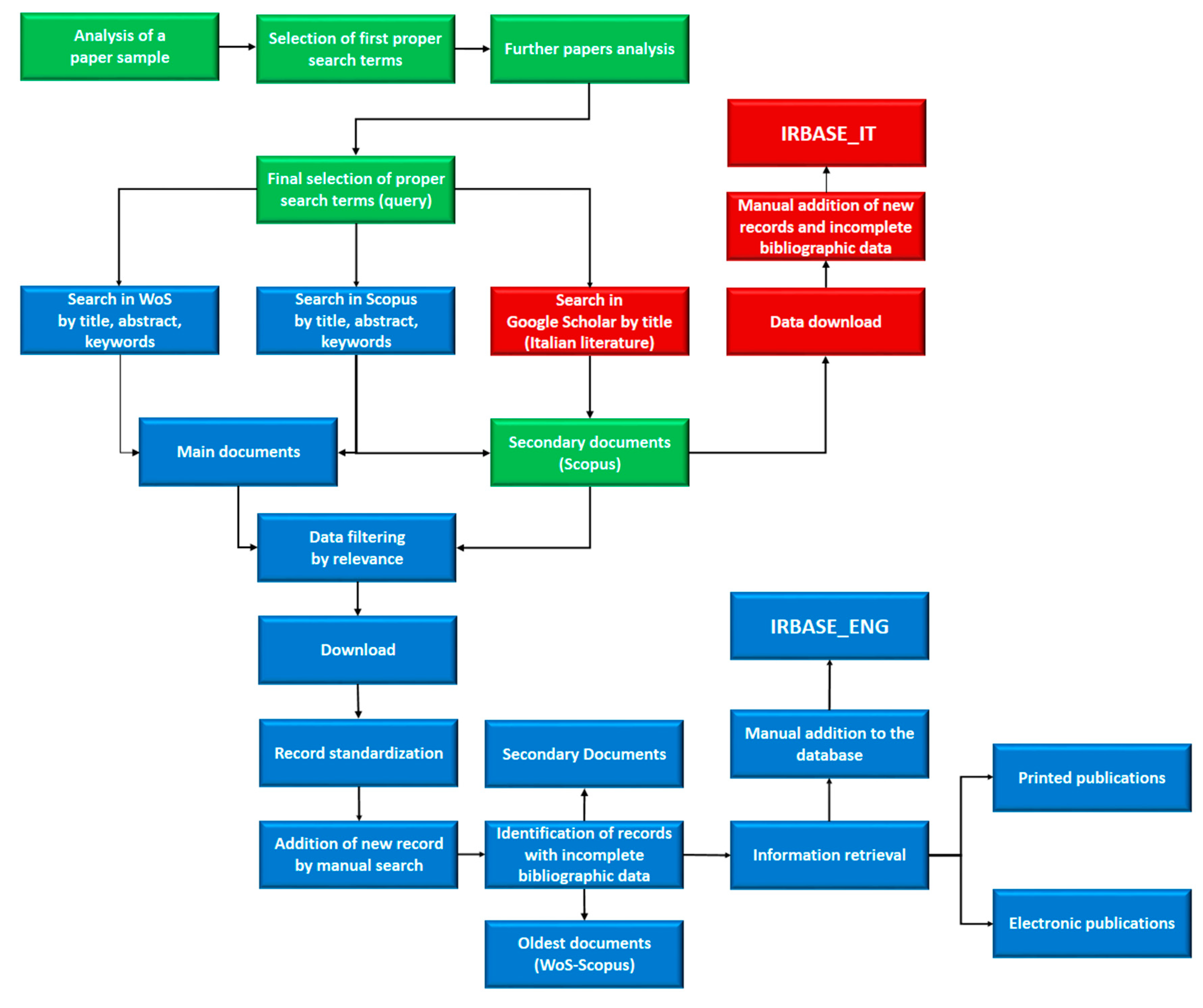
2. Materials and Methods
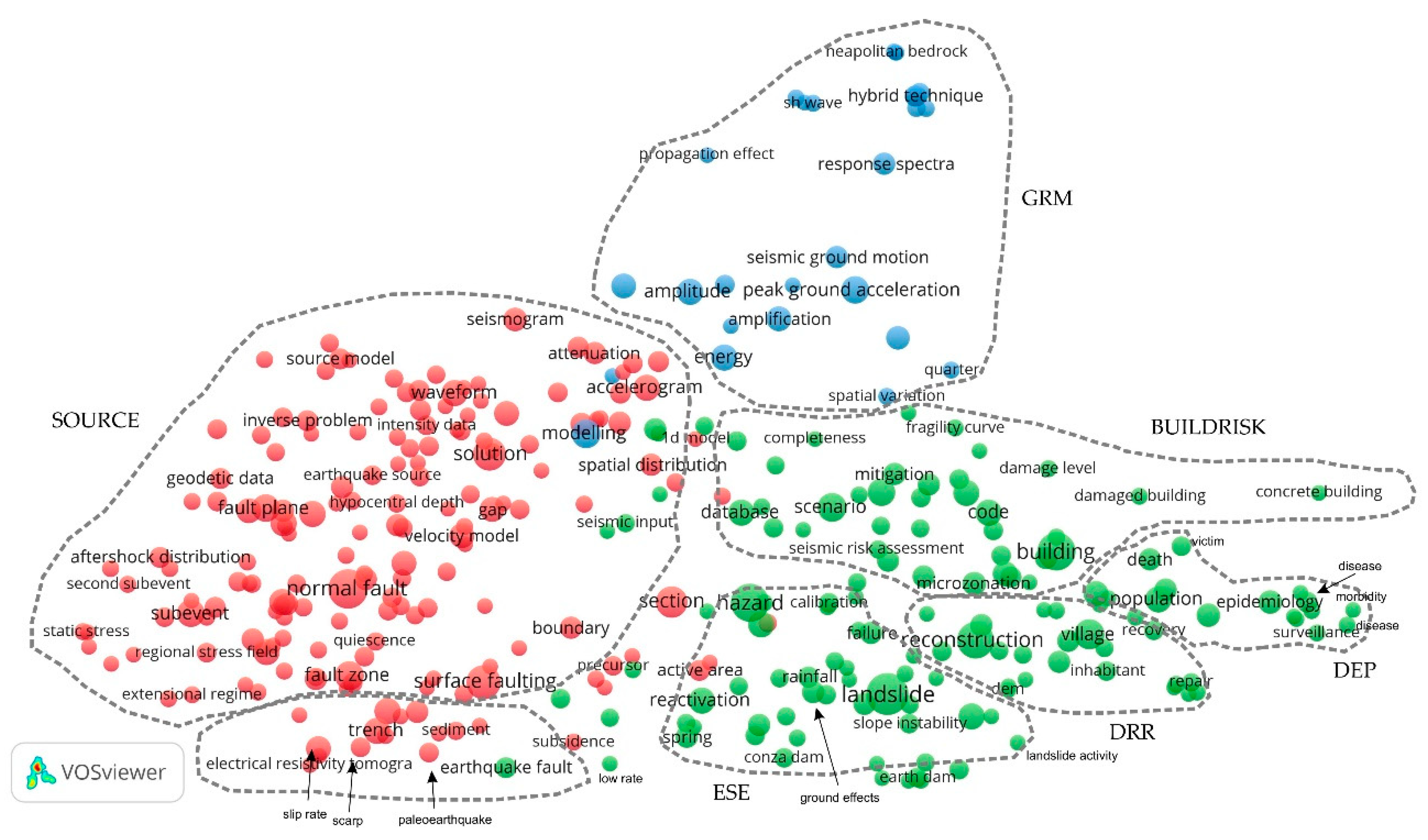
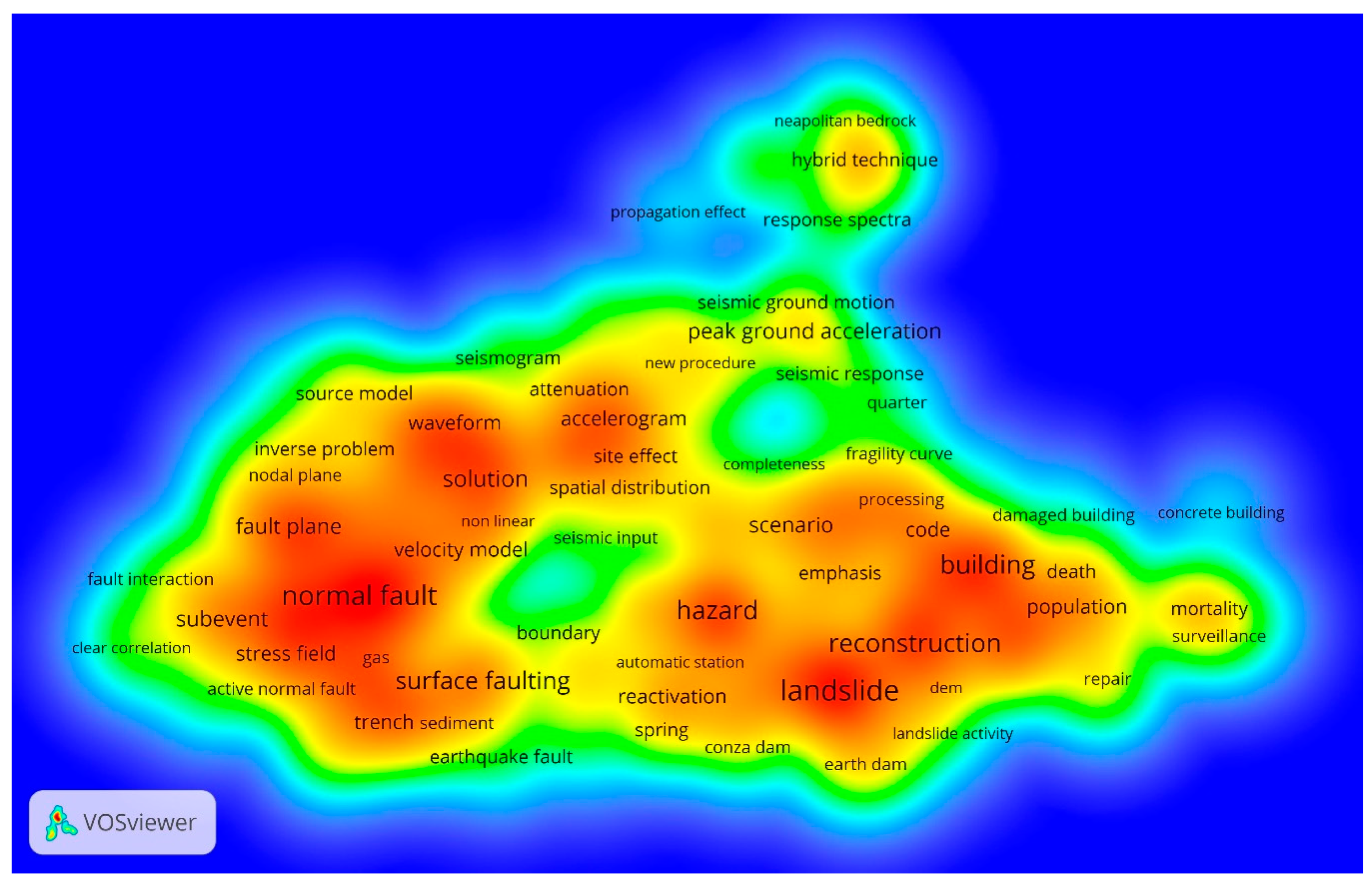
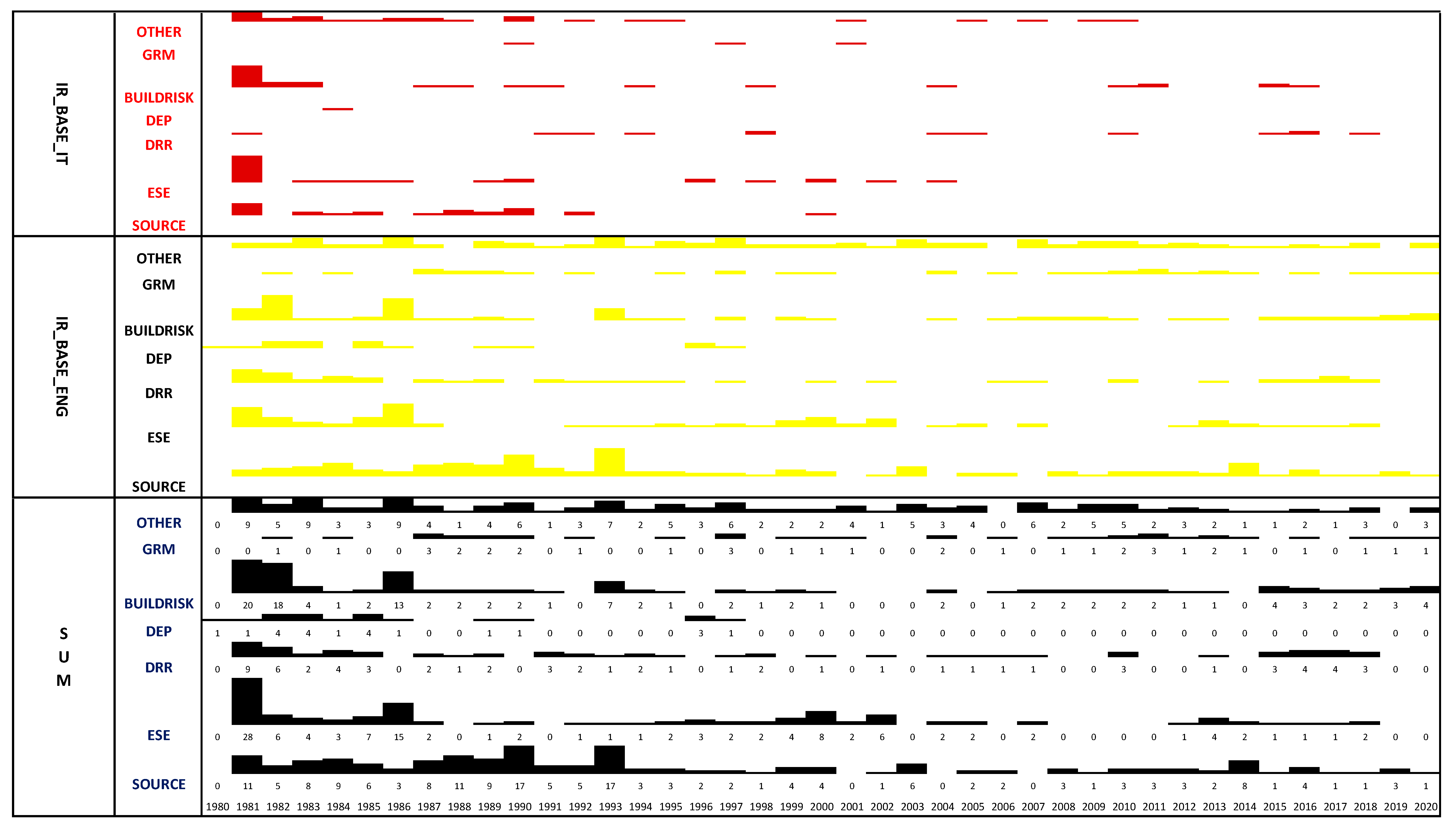
3. Results
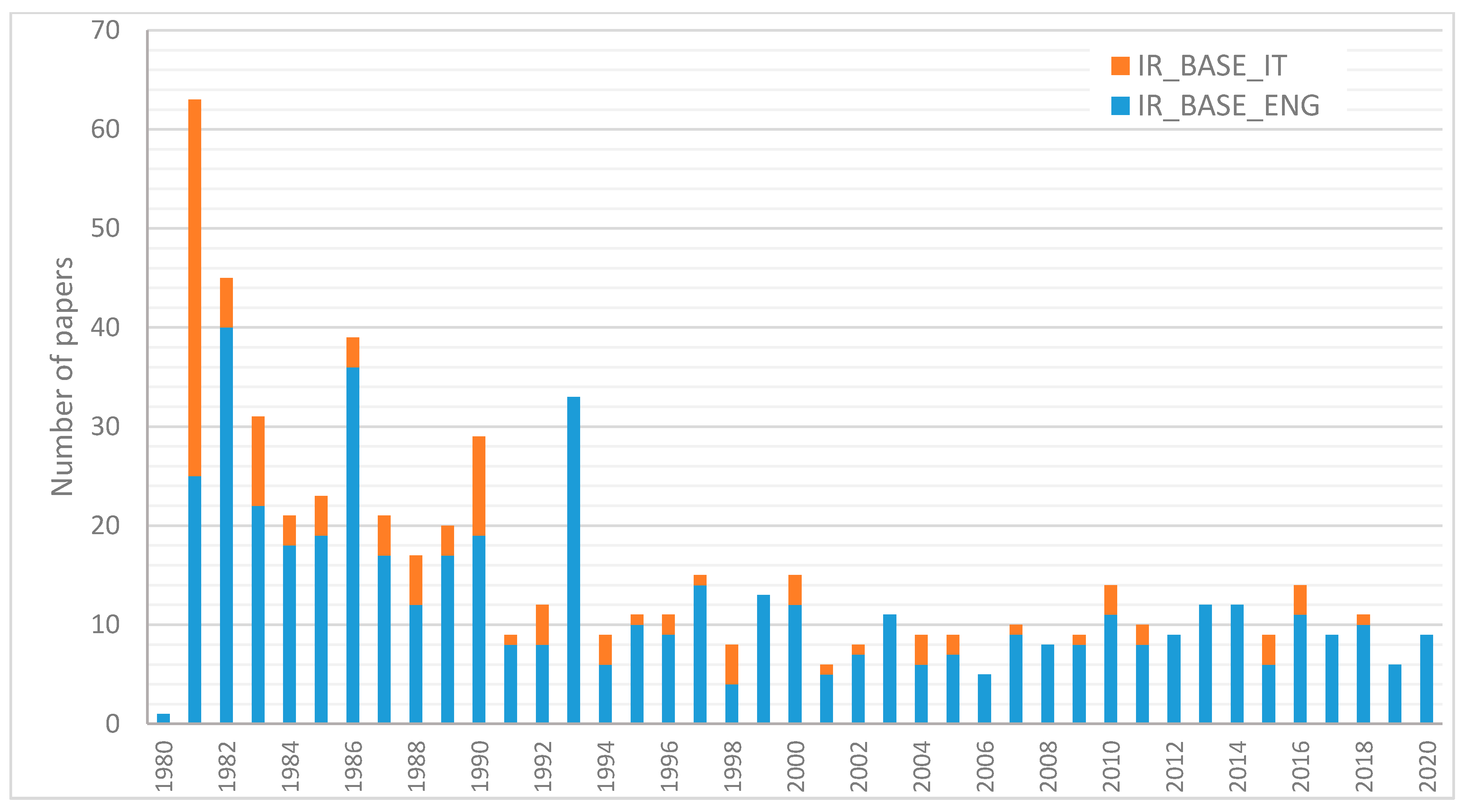
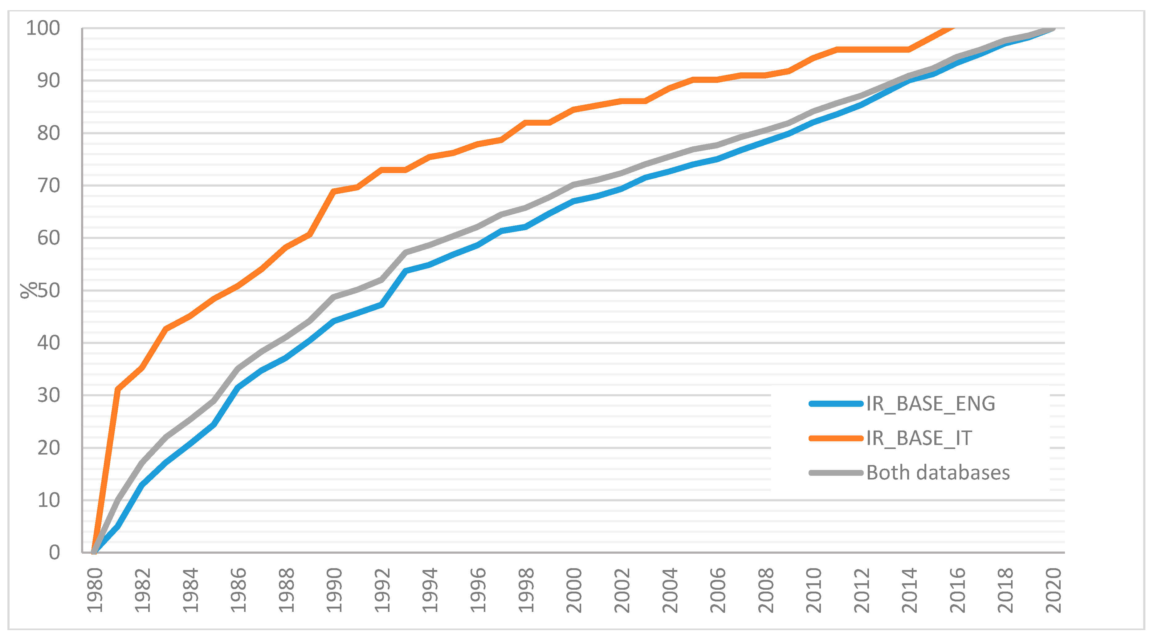
The Two Databases
4. Discussion
4.1. Cluster 1 (Red) (SOURCE)
4.1.1. Studies Concerning the Seismic Source through Mainly Seismological Data
4.1.2. Studies of the Seismic Source by Paleoseismological and Geophysical Investigations
4.2. Cluster 2 (Green)
4.2.1. Earthquake Secondary Effects (ESE)
4.2.2. Disaster Response and Recovery (DRR)
4.2.3. Disaster Epidemiology (DEP)
4.2.4. Building and Infrastructure Damage, Vulnerability, Risk Assessment, and Mitigation (BUILDRISK)
4.3. Cluster 3 (Blue) (GRM)
5. Statistic of Documents by Topics
6. Conclusions
Limitations
Author Contributions
Funding
Acknowledgments
Conflicts of Interest
Appendix A
References
- Guidoboni, E.; Ferrari, G.; Mariotti, D.; Comastri, A.; Tarabusi, G.; Sgattoni, G.; Valensise, G. CFTI5Med, Catalogo dei Forti Terremoti in Italia (461 a.C.-1997) e Nell’area Mediterranea (760 a.C.-1500); Istituto Nazionale di Geofisica e Vulcanologia (INGV): Rome, Italy, 2018. [Google Scholar] [CrossRef]
- Commissione Parlamentare D’Inchiesta. 1991—Commissione Parlamentare D’inchiesta Sulla Attuazione Degli Interventi per la Ricostruzione e lo Sviluppo dei Territori Della Basilicata e Della Campania Colpiti dai Terremoti del Novembre 1980 e Febbraio 1981, Relazione Conclusiva e Propositiva, Vol. I, Tomo I. 1991. Available online: http://www.senato.it/leg/10/BGT/Schede/docnonleg/30412.htm (accessed on 20 June 2020). (In Italian).
- Pantosti, D.; Valensise, G. Faulting mechanism and complexity of the November 23, 1980, Campania- Lucania earthquake, inferred from surface observations. J. Geophys. Res. 1990, 95, 15319–15341. [Google Scholar] [CrossRef]
- Cotecchia, V. Ground deformations and slope instability produced by the earthquake of 23 November 1980 in Campania and Basilicata. Geol. Appl. Idrogeol. 1986, 21, 31–100. [Google Scholar]
- Esposito, E.; Gargiulo, A.; Iaccarino, G.M.; Porfido, S. Distribuzione dei Fenomeni Franosi Riattivati dai Terremoti dell’Appennino Meridionale. In Proceedings of the Censimento Delle Frane del Terremoto del 1980. Proc. Intern. Convention on Prevention of Hydrogeological Hazards, CNR(IRPI), Torino, I, Alba, Torino, Italy, 5–7 November 1996; pp. 409–429. (In Italian). [Google Scholar]
- Blumetti, A.M.; Esposito, E.; Ferreli, L.; Michetti, A.M.; Porfido, S.; Serva, L.; Vittori, E. New Data and Reinterpretation of the November 23, 1980, M 6.9, Irpinia-Lucania Earthquake (Southern Apennine) Coseismic Surface Effects. In Proceedings of the International Workshop “Large-Scale Vertical Movements and Related Gravitational Processes” Special Issue, Studi Geologici Camerti, Siena, Italy, 20–21 September 2002; pp. 19–27. [Google Scholar]
- Waltman, L.; Van Eck, N.J.; Noyons, E. A unified approach to mapping and clustering of bibliometric networks. J. Infometr. 2010, 4, 629–635. [Google Scholar] [CrossRef]
- Liu, X.; Zhan, F.B.; Hong, S.; Niu, B.; Liu, Y. A bibliometric study of earthquake research: 1900–2010. Scientometrics 2012, 92, 747–765. [Google Scholar] [CrossRef]
- Stahl, B.C.; Heersmink, R.; Goujon, P.; Flick, C.; van den Hoven, J.; Wakunuma, K.; Ikonen, V.; Rader, M. Identifying the ethics of emerging information and communication technologies: An essay on issues, concepts and method. In Ethical Impact of Technological Advancements and Applications in Society; Luppicini, R., Ed.; Information Science Reference: Hershey, PA, USA, 2012; pp. 61–79. [Google Scholar]
- Gizzi, F.T.; Leucci, G. Global Research Patterns on Ground Penetrating Radar (GPR). Surv. Geophys. 2018, 39, 1039–1068. [Google Scholar] [CrossRef]
- Knapczyk, A.; Francik, S.; Pedryc, N.; Hebda, T. Bibliometric analysis of research trends in engineering for rural development. In Proceedings of the 17th International Scientific Conference Engineering for Rural Development, Jelgava, Latvia, 23–25 May 2018; pp. 700–707. [Google Scholar] [CrossRef]
- Krauskopf, E. A bibiliometric analysis of the Journal of Infection and Public Health: 2008–2016. J. Infect. Public Health 2018, 11, 224–229. [Google Scholar] [CrossRef]
- Guz, A.N.; Rushchitsky, J.J. Scopus: A system for the evaluation of scientific journals. Int. Appl. Mech. 2009, 45, 351–362. [Google Scholar] [CrossRef]
- Boschi, E.; Pantosti, D.; Slejko, D.; Stucchi, M.; Valensise, G. Special Issue on the meeting “Irpinia Dieci Anni Dopo”. Ann. Geofis. 1993, 36, 351. [Google Scholar]
- Valensise, G. Summary of Contributions on the 23 November 1980, Irpinia earthquake. Ann. Geofis. 1993, XXXVI, 345–351. [Google Scholar]
- Bartol, T.; Mackiewicz-Talarczyk, M. Bibliometric analysis of publishing trends in fiber crops in Google Scholar, Scopus, and Web of Science. J. Nat. Fibers 2015, 12, 531–541. [Google Scholar] [CrossRef]
- Choudhury, M.; Chatterjee, D.; Mukherjee, A. Global topology of word co-occurrence networks: Beyond the two-regime power-law. In Proceedings of the International Conference on Computational Linguistics, Beijing, China, 23–27 August 2010; pp. 162–170. [Google Scholar]
- Van Rijsbergen, C.J. A theoretical basis for the use of co-occurrence data in information retrieval. J. Doc. 1977, 33, 106–119. [Google Scholar] [CrossRef]
- Van Eck, N.J.; Waltman, L. Text mining and visualization using VOSviewer. ISSI Newsl. 2011, 7, 50–54. [Google Scholar]
- Van Eck, N.J.; Waltman, L. Visualizing bibliometric networks. In Measuring Scholarly Impact: Methods and Practice; Ding, Y., Rousseau, R., Wolfram, D., Eds.; Springer: Berlin/Heidelberg, Germany, 2014; pp. 285–320. [Google Scholar]
- Boschi, E.; Mulargia, F.; Mantovani, E.; Bonafede, M.; Dziewonski, A.M.; Woodhouse, J.H. The Irpinia earthquake of November 23, 1980. EOS 1981, 62, 330. [Google Scholar]
- Scarpa, R.; RAPP, S.R. Sismometria del Terremoto del 23/11/1980. Il terremoto campano-lucano del 23.11. 1980: Elaborazione dati sismometrici. Rend. Soc. Geol. Ital. 1981, 4, 427–450. [Google Scholar]
- Berardi, R.; Berenzi, A.; Capozza, F. Campania-Lucania Earthquake on 23 November 1980: Accelerometric Recordings of the Main Quake and Relating Processing; Technical Report, Ente Nazionale per l’Energia Elettrica (ENEL); Contribution to the Annual Convention of the Italian National Research Project on Italian Seismicity: Udine, Italy, 1981; pp. 1–103. [Google Scholar]
- Del Pezzo, E.; Iannaccone, G.; Martini, M.; Scarpa, R. The 23 november 1980 Southern Italy Earthquake. Bull. Seismol. Soc. Am. 1983, 73, 187–200. [Google Scholar]
- Arca, S.; Marchioni, A. I movimenti verticali del suolo nelle zone della Campania et della Basilicata interessate dal sisma del novembre 1980. Boll. Geod. Sci. Affin. 1983, 42, 125–135. [Google Scholar]
- Deschamps, A.; King, G.C.P. The Campania-Lucania (southern Italy) earthquake of 23 November 1980. Earth planet. Sci. Lett. 1983, 62, 296–304. [Google Scholar]
- Deschamps, A.; King, G.C.P. Aftershocks of the Campania-Lucania (Italy) earthquake of 23 November 1980. Bull. Seismol. Soc. Am. 1984, 74, 2483–2517. [Google Scholar]
- Westaway, R.; Jackson, J. Surface faulting in the southern Italian Campania-Basilicata earthquake of 23 November 1980. Nature 1984, 312, 436–438. [Google Scholar] [CrossRef]
- Westaway, R. Geometry of faulting in the Campania-Basilicata (Southern Italy) earthquake of 23rd November 1980. Geophys. J. R. Astron. Soc. 1985, 81, 335. [Google Scholar]
- Crosson, R.S.; Martini, M.; Scarpa, R.; Key, S.C. The southern Italy earthquake of 23 November 1980: An unusual pattern of faulting. Bull. Seismol. Soc. Am. 1986, 76, 381–394. [Google Scholar]
- Crosson, R.S.; Martini, M.; Scarpa, R.; Key, S.C. The southern Italy earthquake of 23 November 1980: An unusual pattern of faulting. Reply. Bull. Seismol. Soc. Am. 1987, 77, 1075–1077. [Google Scholar]
- Westaway, R. The Southern Italy earthquake of 23 November 1980—An unusual pattern of faulting—Comment. Bull. Seismol. Soc. Am. 1987, 77, 1071–1074. [Google Scholar]
- Westaway, R.; Jackson, J. The earthquake of 1980 November 23 in Campania–Basilicata (southern Italy). Geophys. J. R. Astron. Soc. 1987, 90, 375–443. [Google Scholar] [CrossRef]
- Bernard, P.; Zollo, A. The Irpinia (Italy) 1980 earthquake: Detailed analysis of a complex normal faulting. J. Geophys. Res. 1989, 94, 1631–1647. [Google Scholar] [CrossRef]
- Pantosti, D.; Valensise, G. Source geometry and long-term behavior of the 1980, Irpinia earthquake fault based on field geologic observations. Ann. Geofis. 1993, 36, 41–43. [Google Scholar]
- Westaway, R. Revised hypocentre and fault rupture geometry for the 1980 November 23 Campania-Basilicata earthquake in southern Italy. Geophys. J. Int. 1992, 109, 376–390. [Google Scholar] [CrossRef]
- Westaway, R. Fault rupture geometry for the 1980 Irpinia earthquake: A working hypothesis. Ann. Geofis. 1993, 36, 51–69. [Google Scholar]
- Amato, A.; Chiarabba, C.; Malagnini, L.; Selvaggi, G. Three-dimensional P-velocity structure in the region of the MS = 6.9 Irpinia, Italy, normal faulting earthquake. Phys. Earth Planet. Inter. 1992, 75, 111–119. [Google Scholar] [CrossRef]
- Cocco, M.; Pacor, F. The rupture process of the 1980 Irpinia, Italy, earthquake from the inversion of strong motion waveforms. Tectonophysics 1993, 218, 157–177. [Google Scholar] [CrossRef]
- Cocco, M.; Pacor, F. Space-time evolution of the rupture process from the inversion of strong-motion waveforms. Ann. Geofis. 1993, 36, 109–130. [Google Scholar]
- Amato, A.; Selvaggi, G. Aftershock location and P-velocity structure in the epicentral region of the 1980 Irpinia earthquake. Ann. Geofis. 1993, 1, 3–15. [Google Scholar]
- Giardini, D. Teleseismic observation of the November 23 1980, Irpinia earthquake. Ann. Geofis. 1993, 36, 17–25. [Google Scholar]
- Pingue, F.; De Natale, G.; Briole, P. Modeling of the 1980 Irpinia earthquake source: Constraints from geodetic data. Ann. Geofis. 1993, 1, 27–40. [Google Scholar]
- Sirovich, L.; Chiaruttini, C. The influence of source complexity on the polarization and azimuthal radiation of S-Waves, and a simplified synthesis of the macroseismic field. Ann. Geofis. 1993, 1, 81–91. [Google Scholar]
- Bernard, P.; Zollo, A.; Trifu, C.I.; Herrero, A. Details of the rupture kinematics and mechanism of the 1980 Irpinia earthquake: New results and remaining questions. Ann. Geofis. 1993, 1, 71–80. [Google Scholar]
- Vaccari, F.; Harabaglia, P.; Suhadolc, P.; Panza, G.F. The Irpinia (Italy) 1980 earthquake: Waveform modelling of accelerometric data and macroseismic considerations. Ann. Geofis. 1993, 1, 93–108. [Google Scholar]
- Nostro, C.; Cocco, M.; Belardinelli, M.E. Static stress changes in extensional regimes: An application to southern Apennines (Italy). Bull. Seismol. Soc. Am. 1997, 87, 234–248. [Google Scholar]
- Belardinelli, M.E.; Cocco, M.; Coutant, O.; Cotton, F. Redistribution of dynamic stress during coseismic ruptures: Evidence for fault interaction and earthquake triggering. J. Geophys. Res. Solid Earth 1999, 104, 14925–14945. [Google Scholar] [CrossRef]
- Amoruso, A.; Crescentini, L.; Scarpa, R. Faulting geometry for the complex 1980 Campania-Lucania earthquake from levelling data. Geophys. J. Int. 2005, 162, 156–168. [Google Scholar] [CrossRef]
- Amoruso, A.; Crescentini, L.; Di Lieto, B.; Scarpa, R. Faulting mechanism of the Campania-Lucania 1980 earthquake, Italy, from high-resolution, 3D velocity structure, aftershock relocation, fault-plane solutions, and post-seismic deformation modeling. Ann. Geophys. 2011, 54, 806–821. [Google Scholar]
- Pantosti, D.; Schwartz, D.P.; Valensise, G. Paleoseismologic and geomorphic observations along the 1980 Irpinia surface fault rupture, southern Apennines (Italy). EOS Trans. AGU 1989, 70, 1349. [Google Scholar]
- D’Addezio, G.; Pantosti, D.; Valensise, G. Paleoearthquakes along the Irpinia fault at Pantano di San Gregorio Magno (Southern Italy). Alp. Mediterr. Quat. 1991, 4, 121–135. [Google Scholar]
- Pantosti, D.; D’Addezio, G.; Cinti, F.R. Paleoseismological Evidence of Repeated Large Earthquakes along the 1980 Irpinia Earthquake Fault. Ann. Geofis. 1993, 36, 321–330. [Google Scholar]
- Pantosti, D.; Schwartz, D.P.; Valensise, G. Paleoseismology along the 1980 surface rupture of the Irpinia fault: Implications for earthquake recurrence in the southern Apennines, Italy. J. Geophys. Res. Solid Earth 1993, 98, 6561–6577. [Google Scholar] [CrossRef]
- Improta, L.; Zollo, A.; Bruno, P.P.; Herrero, A.; Villani, F. High-resolution seismic tomography across the 1980 (Ms 6.0) Southern Italy earthquake fault scarp. Geophys. Res. Lett. 2003, 30. [Google Scholar] [CrossRef]
- Bruno, P.P.; Castiello, A.; Improta, L. Ultrashallow seismic imaging of the causative fault of the 1980, M6.9, southern Italy earthquake by pre-stack depth migration of dense wide-aperture data. Geophys. Res. Lett. 2010, 37, L19302. [Google Scholar] [CrossRef]
- Galli, P.A.C.; Giocoli, A.; Peronace, E.; Piscitelli, S.; Quadrio, B.; Bellanova, J. Integrated near surface geophysics across the active Mount Marzano Fault System (southern Italy): Seismogenic hints. Int. J. Earth Sci. 2014, 103, 315–325. [Google Scholar] [CrossRef]
- Galli, P.A.C.; Peronace, E.; Quadrio, B.; Esposito, G. Earthquake fingerprints along fault scarps: A case study of the Irpinia 1980 earthquake fault (southern Apennines). Geomorphology 2014, 206, 97–106. [Google Scholar] [CrossRef]
- Vassallo, M.; Festa, G.; Bobbio, A.; Serra, M. Low shear velocity in a normal fault system imaged by ambient noise cross correlation: The case of the Irpinia fault zone, Southern Italy. J. Geophys. Res. Solid Earth 2016, 121, 4290–4305. [Google Scholar] [CrossRef]
- Lo Re, D.; Florio, G.; Ferranti, L.; Ialongo, S.; Castiello, G. Self-constrained inversion of microgravity data along a segment of the Irpinia fault. J. Appl. Geophys. 2016, 124, 148–154. [Google Scholar] [CrossRef]
- Guerricchio, A.; Melidoro, G. Pseudo-tectonic mass movements in the southern Apennines. [Movimenti di massa pseudo-tettonici nell’appennino dell’Italia meridionale]. Geol. Appl. Idrogeol. 1981, 16, 251–294. [Google Scholar]
- Maugeri, M.; Motta, E.; Sorriso Valvo, M. Senerchia landslide triggered by the 23 November 1980 earthquake. In Proceedings of the 4th International Congress—International Association of Engineering Geology, New Delhi, India, 10–15 December 1982; Volume 8, pp. 139–149. [Google Scholar]
- Bousquet, J.C.; Gars, G.; Lanzafame, G.; Philip, H. Surface breaks of gravitational origin at the time of the Irpinia earthquake-23/11/1980; southern Italy. Geol. Appl. Idrogeol. 1983, 18, 427–435. [Google Scholar]
- Da Roit, R.; Fontanive, A.; Lojelo, L.; Muzzi, F.; Spat, G. Terremoto Campano-Lucano del 23 Novembre 1980: Evidenze di Liquefazione di Terreni non Coesivi Saturi. Comm. ENEA-ENEL per lo Studio dei Problemi Sismici Connessi con la Realizzazione di Impianti Nucleari. In Proceedings of the Conv. Ann. del CNR-PFG su Sismicità d’Italia, stato delle Conoscenze e Qualità della Normativa Sismica, 1981, Udine, Italy, 2–14 May 1982. (In Italian). [Google Scholar]
- Del Prete, M.; Liuzzi, G.T. Results of a preliminary study of the Calitri (AV) landslide triggered by the 23 November 1980 earthquake. [Risultati dello studio preliminare della frana di Calitri (AV) mobilitata dal terremoto del 23 Novembre 1980]. Geol. Appl. Idrogeol. 1981, 16, 153–165. [Google Scholar]
- Faccioli, E. Engineering Seismology Aspects of the M-6.5, Southern Italy Earthquake of Nov. 23, 1980: A Preliminary Review. International Conferences on Recent Advances in Geotechnical Earthquake Engineering and Soil Dynamics. 1981, p. 16. Available online: https://scholarsmine.mst.edu/icrageesd/01icrageesd/session08/16 (accessed on 20 May 2020).
- Hutchinson, J.N.; Del Prete, M. Landslides at Calitri, southern Apennines, reactivated by the earthquake of 23rd November 1980. Geol. Appl. Idrogeol. 1985, 20, 9–38. [Google Scholar]
- Baldassarre, G. Geological effects of the 23 November 1980 earthquake in Atella, outskirts of Basilicata. [Effetti geologici del sisma del 23 Novembre 1980 nella periferia dell’abitato di Atella (Basilicata)]. Geol. Appl. Idrogeol. 1981, 16, 227–238. [Google Scholar]
- Agnesi, V.; Carrara, A.; Macaluso, T.; Monteleone, S.; Pipitone, G.; Sorriso-Valvo, M. Preliminary observations of slope instability phenomena induced by the earthquake of November 1980 on the upper valley of Sele river. [Osservazioni preliminari sui fenomeni di instabilita dei versanti indotti dal sisma del 1980 nell’alta valle del Sele]. Geol. Appl. Idrogeol. 1982, 17, 79–93. [Google Scholar]
- Genevois, R.; Prestininzi, A. Deformations and mass movements induced by the November 23rd, 1980 earthquake in the middle valley of the Tammaro River-BN. [Deformazioni e movimenti di massa indotti dal sisma del 23-11-1980 nella media valle del F. Tammaro (BN)]. Geol. Appl. Idrogeol. 1982, 17, 305–318. [Google Scholar]
- Salvemini, A. Basic aspects of phenomena of instability in the limestone massifs of Monti Cervialto and Terminio-Tuoro (southern Apennines) induced by the earthquake of 23 November 1980. [Aspetti fondamentali dei fenomeni di dissesto nei massicci carbonatici dei Monti Cervialto e Terminio-Tuoro (Appennino Meridionale) indotti dal sisma del 23 novembre 1980]. Geol. Appl. Idrogeol. 1982, 17, 209–218. [Google Scholar]
- Alexander, D. Preliminary assessment of landslides resulting from the earthquake of 23rd November 1980 in Southern Italy. Disasters 1981, 5, 376–383. [Google Scholar] [CrossRef]
- Porfido, S.; Esposito, E.; Vittori, E.; Tranfaglia, G.; Michetti, A.M.; Blumetti, M.; Ferreli, L.; Guerrieri, L.; Serva, L. Areal distribution of ground effects induced by strong earthquakes in the southern Apennines (Italy). Surv. Geophys. 2002, 23, 529–562. [Google Scholar] [CrossRef]
- Porfido, S.; Esposito, E.; Guerrieri, L.; Vittori, E.; Tranfaglia, G.; Pece, R. Seismically induced ground effects of the 1805, 1930 and 1980 earthquakes in the Southern Apennines, Italy. Boll. Soc. Geol. Ital. 2007, 126, 333–346. [Google Scholar]
- Cotecchia, V.; Salvemini, A. Correlation between seismic events and discharge variations at Caposele and Cassano Irpino springs, with particular reference to the 23 November 1980 earthquake. [Correlazione fra eventi sismici e variazione di portata alle sorgenti di Caposele e Cassano Irpino, con particolare riferimento al sisma del 23 Novembre 1980]. Geol. Appl. Idrogeol. 1981, 16, 167–192. [Google Scholar]
- Wasowski, J.; Del Gaudio, V.; Pierri, P.; Capolongo, D. Factors controlling seismic susceptibility of the Sele valley slopes: The case of the 1980 Irpinia earthquake re-examined. Surv. Geophys. 2002, 23, 563–593. [Google Scholar] [CrossRef]
- Del Prete, M. Example of mudslide hazard in the Southern Apennines (Italy). Ann. Geofis. 1993, 36, 271–276. [Google Scholar]
- Parise, M.; Wasowski, J. Landslide activity maps for landslide hazard evaluation: Three case studies from Southern Italy. Nat. Hazards 1999, 20, 159–183. [Google Scholar] [CrossRef]
- Capolongo, D.; Refice, A.; Mankelow, J. Evaluating earthquake-triggered landslide hazard at the basin scale through GIS in the Upper Sele river Valley. Surv. Geophys. 2002, 23, 595–625. [Google Scholar] [CrossRef]
- Martino, S.; Prestininzi, A.; Romeo, R.W. Earthquake-induced ground failures in Italy from a reviewed database. Nat. Hazards Earth Syst. Sci. 2014, 14, 799–814. [Google Scholar] [CrossRef]
- Cavazzani, A. Social and Institutional Impact of the 1980 Earthquake in Southern Italy: Problems and Prospects of Civil Protection; The Council of Yugoslav Association of Self-Managed Communities of Interest for Scientific Research: Ljubljana, Slovenia, 1982; pp. 425–436. [Google Scholar]
- Ventura, F. The earthquake in Campania and Basilicata (Italy) of 23rd November 1980—The nature of the state’s emergency interventions and the future quality of reconstruction. In Tenth World Conference of Sociology, Mexico; ISIG Publication: Gorizia, Italy, 1982. [Google Scholar]
- Ventura, F. The long-term effects of the 1980 earthquake on the villages of southern Italy. Disasters 1984, 8, 11. [Google Scholar] [CrossRef]
- D’Souza, F. Recovery following the South Italian earthquake, November 1980: Two contrasting examples. Disasters 1982, 6, 101–109. [Google Scholar] [CrossRef]
- D’Souza, F. Recovery following the south Italian earthquake, November 1980: Contrasting examples. Ekistics 1984, 51, 476–482. [Google Scholar] [CrossRef]
- Alexander, D. Housing crisis after natural disaster: The aftermath of the November 1980 southern Italian earthquake. Geoforum 1984, 15, 489–516. [Google Scholar] [CrossRef]
- Caporale, R.; Rossi, I.; Chaeretakis, A. Reconstruction and Socio-Cultural Systems, A Long-Range Study of Reconstruction Processes Following the November 23, 1980 Earthquake in Southern Italy; Institute for Italian-American Studies: New York, NY, USA, 1985; Unpublished report. [Google Scholar]
- Alexander, D. Preserving the Identity of Small Settlements during Post-Disaster Reconstruction in Italy. Disasters 1989, 13, 228–236. [Google Scholar] [CrossRef] [PubMed]
- Chubb, J. Three earthquakes: Political response, reconstruction, and the institutions: Belice (1968), Friuli (1976), Campania (1980). In Disastro: Disasters in Italy Since 1860: Culture, Politics, Society; Dickie, J., Foot, J., Snowden, F.M., Eds.; Palgrave: New York, NY, USA, 2002; pp. 186–210. [Google Scholar]
- Forino, G.; Ciccarelli, S.; Bonamici, S.; Perini, L.; Salvati, L. Developmental Policies, Long-Term Land-Use Changes and the Way Towards Soil Degradation: Evidence from Southern Italy. Scott. Geogr. J. 2015, 131, 123–140. [Google Scholar] [CrossRef]
- Porfido, S.; Alessio, G.; Gaudiosi, G.; Nappi, R.; Spiga, E. The resilience of some villages 36 years after the Irpinia-Basilicata (Southern Italy) 1980 earthquake. In Proceedings of the Workshop on World Landslide Forum in Advancing Culture of Living with Landslides, Ljubljana, Slovenija, 29 May–2 June 2017; Mikoš, M., Vilímek, V., Yin, Y., Sassa, K., Eds.; Springer: Cham, Switzerland, 2017; pp. 121–133. [Google Scholar] [CrossRef]
- Greco, D.; Faustini, A.; Forastiere, F.; Galanti, M.R.; Magliola, M.E.; Moro, M.L.; Piergentili, P.; Rosmini, F.; Stazi, M.A.; Luzi, S.; et al. Epidemiological surveillance of diseases following the earthquake of 23rd November 1980 in Southern Italy. Disasters 1981, 5, 398–406. [Google Scholar] [CrossRef] [PubMed]
- Alexander, D. Disease epidemiology and earthquake disaster. The example of Southern Italy after the 23 November 1980 earthquake. Soc. Sci. Med. 1982, 16, 1959–1969. [Google Scholar] [CrossRef]
- Bruycker, M.D.; Greco, D.; Lechat, M.F. The 1980 earthquake in Southern Italy—Morbidity and mortality. Int. J. Epidemiol. 1985, 14, 113–117. [Google Scholar] [CrossRef] [PubMed]
- Berger, E.; Studer, J. Southern Italy Earthquake, November 23, 1980. Reconnaissance Summary; Earthquake Engineering Research Institute: Oakland, CA, USA, 1981; pp. 88–94. [Google Scholar]
- Guerpinar, A.; Vardanega, C.; Ries, E.R. November 23, 1980 Irpinia earthquake (terremoto campano lucano) observations of soil-structure interaction effects. In Proceedings of the 6th International Conference on Structural Mechanics in Reactor Technology. Mechanical and Thermal Problems of Future Fusion Reactor Power Plants, Paris, France, 17–21 August 1981; p. 20. Available online: https://www.scopus.com/inward/record.uri?eid=2-s2.0-0019708742&partnerID=40&md5=01c2a1d6484e65b7b3ecd86fa55993bd (accessed on 13 June 2020).
- Postpischl, D.; Ferrari, G.; Giovani, L.; Spadea, M.C.; Vecchi, M.; Stucchi, M.; Bottari, A.; Lo Giudice, E.; Baldassarre, R.; Branno, A.; et al. Il terremoto irpino del 23 Novembre 1980; rilievo macrosismico. Stato di avanzamento al 12-5-81. Rend. Soc. Geol. Ital. 1981, 4, 503–505. [Google Scholar]
- Postpischl, D.; Perrone, V. Il Terremoto del 23/11/1980 in Campania e Lucania: Rilievo Macrosismico; C.N.R. Progetto Finalizzato Geodinamica: Pisa, Italy, 1981; p. 121. [Google Scholar]
- Postpischl, D.; Brano, A.; Esposito, E.G.L.; Ferrari, G.; Marturano, A.; Porfido, S.; Rinaldis, V.; Stucchi, M. The Irpinia earthquake of November 23, 1980. Atlas Isoseismal Maps Ital. Earthq. 1985, 114, 152–157. [Google Scholar]
- Coburn, A.W.; Hughes, R.E.; Nash, D.F.T.; Spence, R.J.S. Damage assessment and ground motion in the Italian earthquake of 23.11.1980. In Proceedings of the 7th European conference on Earthquake Engineering, Athens, Greece, 20–25 September 1982; pp. 101–108. [Google Scholar]
- Ammann, W.; Porro, B. Earthquake in southern Italy of 23 November 1980 engineering aspects and interpretation of building damage. In Proceedings of the 7th European Conference on Earthquake Engineering, Athens, Greece, 20–25 September 1982; Volume 1, pp. 151–158. [Google Scholar]
- Hojjat, A. Behavior of reinforced concrete buildings during the southern Italy earthquake of November 23, 1980. In Proceedings of the 7th European Conference on Earthquake Engineering, Athens, Greece, 20–25 September 1982; Volume 1, pp. 143–150. [Google Scholar]
- Cotecchia, V.; Nuzzo, G.; Salvemini, A.; Tafuni, N.; Pavoncelli, G. Tunnel and structural analysis of large underground structure damaged by the earthquake of November 23, 1980. In Proceedings of the Internazional Sypmosium on Geology Problems in Seismic Areas, Bari, Italy, 13–19 April 1986; Volume 21, pp. 329–352. [Google Scholar]
- Braga, F.; Dolce, M.; Liberatore, D. A Statistical Study on Damaged Buildings and Ensuing Review of MSK-76 Scale, Southern Italy November 23 1980 Earthquake. In Progetto Finalizzato di Geodinamica; CNR Italia, Pub. No. 503 (7ECEE, Athens): Athens, Greece, 1982; pp. 65–84. [Google Scholar]
- Braga, F.; Liberatore, D.; Dolce, M. Fast and reliable damage estimation for optimal relief operations. In Earthquake Relief in Less Industrialized Areas; Schuppisser, S., Studer, J.A., Eds.; Balkema: Rotterdam, The Netherlands, 1984; pp. 145–151. [Google Scholar]
- Rota, M.; Penna, A.; Strobbia, C. Processing Italian damage data to derive typological fragility curve. Soil Dyn. Earthq. Eng. 2008, 28, 933–947. [Google Scholar] [CrossRef]
- Del Gaudio, C.; Di Ludovico, M.; Polese, M.; Manfredi, G.; Prota, A.; Ricci, P.; Verderame, G.M. Seismic fragility for Italian RC buildings based on damage data of the last 50 years. Bull. Earthq. Eng. 2020, 18, 2023–2059. [Google Scholar] [CrossRef]
- Dolce, M.; Speranza, E.; Giordano, F.; Borzi, B.; Bocchi, F.; Conte, C.; Di Meo, A.; Faravelli, M.; Pascale, V. Observed damage database of past Italian earthquakes: The Da. DO WebGIS. Boll. Geofis. Teor. Appl. 2019, 60, 141–164. [Google Scholar]
- Scire, E.; Siro, L.; Stucchi, M.; Gaiazzi, M. Geo- seismic investigations and urban planning after the Irpinia- Basilicata 1980 earthquake: Part 2, the case of S. Angelo dei Lombardi (Italy). Geol. Appl. Idrogeol. 1986, 21, 387–397. [Google Scholar]
- Scire, E.; Siro, L.; Stucchi, M.; Gaiazzi, M. Geo-seismic investigations and urban planning after the Irpinia-Basilicata 1980 earthquake: Part 1, the case of Caposele and Conza della Campania. Geol. Appl. Idrogeol. 1986, 21, 441–450. [Google Scholar]
- Chiocchini, U.; Cherubini, C. Seismic microzoning of the Lioni village destroyed by the November 23rd 1980 earthquake (Irpinia, Campano-Lucano Apennine). Geol. Appl. Idrogeol. 1986, 21, 341–362. [Google Scholar]
- Maugeri, M.; Carrubba, P. Microzonation for ground motion during the 1980 Irpinia earthquake at Calabritto, Italy. In Proceedings of the 14nd International Conference on Soil Mechanics and Foundation Engineering, Hamburg, Germany, 6–12 September 1997; pp. 81–96. [Google Scholar]
- Siro, L. Microzonation in emergency: A short technical report. The Italian Geodynamics Project, Publication Number 503, National Research Council of Italy. Presented at the VII ECEE, Athens, Greece, 6–7 September 1982; pp. 53–63. [Google Scholar]
- Siro, L. Emergency microzonations by Italian Geodynamics Project after November 23, 1980 earthquake. In Proceedings of the 3rd International Conference on Microzonation, Seattle, WA, USA, 28 June–1 July 1982; Volume 3, pp. 1417–1427. [Google Scholar]
- Rovelli, A.; Bonamassa, O.; Cocco, M.; Di Bona, M.; Mazza, S. Scaling laws and spectral parameters of the ground motion in active extensional areas in Italy. Bull. Seismol. Soc. Am. 1988, 78, 530–560. [Google Scholar]
- Bosco, G.; Dolce, M.; Marino, M. Artificial accelerograms consistent with the 1980 Irpinia earthquake. In Proceedings of the Tenth World Conference on Earthquake Engineering, Madrid, Spain, 24 July 1992; pp. 895–900. [Google Scholar]
- Convertito, V.; De Matteis, R.; Cantore, L.; Zollo, A.; Iannaccone, G.; Caccavale, M. Rapid estimation of ground-shaking maps for seismic emergency management in the Campania Region of southern Italy. Nat. Hazards 2010, 52, 97–115. [Google Scholar] [CrossRef]
- Cultrera, G.; Ameri, G.; Saraò, A.; Cirella, A.; Emolo, A. Ground-motion simulations within ShakeMap methodology: Application to the 2008 Iwate-Miyagi Nairiku (Japan) and 1980 Irpinia (Italy) earthquakes. Geophys. J. Int. 2013, 193, 220–237. [Google Scholar] [CrossRef]
- Nunziata, C.; Costa, G.; Marrara, F.; Panza, G.F. Validated Estimation of Response Spectra for the 1980 Irpinia Earthquake in the Eastern Area of Naples. Earthq. Spectra 2000, 16, 643–660. [Google Scholar] [CrossRef]
- Di Giulio, G.; Improta, L.; Calderoni, G.; Rovelli, A. A study of the seismic response of the city of Benevento (Southern Italy) through a combined analysis of seismological and geological data. Eng. Geol. 2008, 97, 146–170. [Google Scholar] [CrossRef]
- Maresca, R.; Nardone, L.; Pasquale, G.; Pinto, F.; Bianco, F. Effects of surface geology on seismic ground motion deduced from ambient-noise measurements in the town of Avellino, Irpinia region (Italy). Pure Appl. Geophys. 2012, 169, 1173–1188. [Google Scholar] [CrossRef]
- Maresca, R.; Nardone, L.; Gizzi, F.T.; Potenza, M.R. Ambient noise HVSR measurements in the Avellino historical centre and surrounding area (southern Italy). Correlation with surface geology and damage caused by the 1980 Irpinia-Basilicata earthquake. Measurement 2018, 130, 211–222. [Google Scholar] [CrossRef]
- Rovida, A.; Camassi, R.; Gasperini, P.; Stucchi, M. (Eds.) Catalogo Parametrico dei Terremoti Italiani (CPTI11); Istituto Nazionale di Geofisica e Vulcanologia (INGV): Milano, Bologna, 2011. [Google Scholar] [CrossRef]


Publisher’s Note: MDPI stays neutral with regard to jurisdictional claims in published maps and institutional affiliations. |
© 2020 by the authors. Licensee MDPI, Basel, Switzerland. This article is an open access article distributed under the terms and conditions of the Creative Commons Attribution (CC BY) license (http://creativecommons.org/licenses/by/4.0/).
Share and Cite
Gizzi, F.T.; Potenza, M.R. The Scientific Landscape of November 23rd, 1980 Irpinia-Basilicata Earthquake: Taking Stock of (Almost) 40 Years of Studies. Geosciences 2020, 10, 482. https://doi.org/10.3390/geosciences10120482
Gizzi FT, Potenza MR. The Scientific Landscape of November 23rd, 1980 Irpinia-Basilicata Earthquake: Taking Stock of (Almost) 40 Years of Studies. Geosciences. 2020; 10(12):482. https://doi.org/10.3390/geosciences10120482
Chicago/Turabian StyleGizzi, Fabrizio Terenzio, and Maria Rosaria Potenza. 2020. "The Scientific Landscape of November 23rd, 1980 Irpinia-Basilicata Earthquake: Taking Stock of (Almost) 40 Years of Studies" Geosciences 10, no. 12: 482. https://doi.org/10.3390/geosciences10120482
APA StyleGizzi, F. T., & Potenza, M. R. (2020). The Scientific Landscape of November 23rd, 1980 Irpinia-Basilicata Earthquake: Taking Stock of (Almost) 40 Years of Studies. Geosciences, 10(12), 482. https://doi.org/10.3390/geosciences10120482