1. Introduction
Adaptive reuse is an architectural strategy that aims to transform and reprogram existing building stock and has gained increasing importance in the contexts of sustainability, cultural continuity, and urban resilience. In particular, the conversion of industrial heritage buildings into hospitality, cultural, or public uses has been widely addressed both in architectural practice and in academic literature [
1,
2,
3]. Recent studies have further examined such transformations through the lens of spatial experience, highlighting how adaptive reuse interventions reshape perceptual and configurational qualities in former industrial buildings [
4].
However, a substantial portion of this discourse evaluates adaptive reuse processes primarily through structural interventions, energy performance, economic sustainability, or cultural values, while the transformation of plan-level spatial organization and spatial hierarchy is often treated as a secondary concern. Recent reviews have further highlighted the growing integration of daylighting performance, visual comfort, and energy efficiency within multi-objective optimization frameworks in building adaptation research [
5]. While such approaches address environmental performance criteria and integrated thermal–visual comfort objectives, the configurational implications of plan-level spatial restructuring remain comparatively underexamined.
Yet programmatic transformation entails not only a change of functions but also a fundamental reconfiguration of interior spatial organization, circulation relationships, and spatial priorities. Such plan-level transformations necessitate the re-establishment of spatial hierarchies that directly shape user experience. Despite this, studies that examine interior plan layouts and spatial hierarchy through quantitative and comparative approaches remain limited within the adaptive reuse literature [
6,
7].
The Space Syntax approach, developed for the analysis of spatial configuration, enables the interpretation of interior spatial organization through measures of accessibility, connectivity, and hierarchical relationships [
8,
9,
10]. Nevertheless, a large proportion of Space Syntax-based studies focus on the urban scale, while building-scale analyses tend to rely on multiple cases and offer generalized readings based on average values [
11,
12]. Studies that compare the pre- and post-intervention conditions of a single building at the plan level within the same architectural boundaries remain relatively limited.
Within this context, the primary gap in the literature does not merely concern the lack of building-scale analyses, but more specifically the relative scarcity of analytically controlled investigations that isolate the role of plan-level design decisions in the redistribution of spatial hierarchy during adaptive reuse. While previous studies have examined adaptive reuse in terms of structural performance, heritage values, or user perception, fewer studies have systematically traced how spatial hierarchy is restructured within the same architectural boundaries when programmatic transformation occurs. As a result, the configurational mechanisms through which architectural design decisions are associated with differentiated spatial hierarchies across floors remain underexplored.
Accordingly, this study does not aim to demonstrate that adaptive reuse alters spatial hierarchy in a general sense; rather, it seeks to analytically examine how spatial hierarchy is reconfigured in relation to program-driven design interventions within a single building envelope. By comparing pre- and post-intervention configurations under identical boundary conditions, the study adopts an analytically controlled comparative protocol that allows spatial transformation to be interpreted in relation to plan-level architectural decisions rather than contextual variation.
In this respect, the contribution of the study lies not in identifying predictable public–private distributions across floors, but in making visible how such distributions are configurationally produced and reorganized under programmatic transformation. The novelty therefore resides not in the predictability of public–private differentiation, but in the controlled comparison of plan-level configurational change within a fixed architectural envelope. Through visibility-based syntactic measures, the study advances a design-oriented analytical reading that connects quantitative outputs to architecturally meaningful decision nodes within the plan organization.
Accordingly, the research is structured around the following questions:
RQ1: How is spatial hierarchy reconfigured at the plan level when programmatic transformation occurs within the same architectural envelope?
RQ2: How does this redistribution differ between the ground floor and upper floors under identical boundary conditions?
RQ3: In what ways can visibility-based syntactic measures reveal the configurational mechanisms underlying this redistribution?
Accordingly, the study advances a set of analytical propositions that guide the comparative reading of spatial configurations within a controlled single-case analytical protocol. These propositions are not intended as statistically generalizable hypotheses, but as case-bound interpretive premises that structure the configurational analysis.
These propositions do not function as statistically testable hypotheses, but as structured analytical parameters guiding controlled configurational comparison.
AP1: The ground floor is examined to determine whether measurable amplification of integration is observed at circulation nodes introduced through program-driven restructuring.
AP2: Upper floors are examined to determine whether comparatively more segregated and configurational structures emerge under program-driven reorganization.
AP3: The redistribution of spatial hierarchy is examined in terms of whether it occurs selectively across floors rather than uniformly across the building.
These propositions function as interpretive lenses for examining configurational change within a controlled case condition. The contribution of the study lies not in confirming expected public–private distributions, but in revealing the configurational mechanisms through which design decisions produce differentiated hierarchical conditions across floors.
Through the use of visibility-based syntactic measures as an interpretive design tool, this study contributes to the literature by examining how spatial hierarchy is selectively reconfigured at the plan level during the adaptive reuse process. These analytical propositions are not intended to establish generalizable causal laws, but to structure and guide an interpretive, design-oriented examination of configurational change within a controlled single-case condition.
1.1. Conceptual Framework: Spatial Hierarchy as an Architectural Construct
1.1.1. The Concept of Spatial Hierarchy
Spatial hierarchy is a fundamental organizational principle defined through the degrees of accessibility, circulation relationships, and spatial priorities offered by architectural space to its users. In architectural theory, this concept has been addressed through various perspectives, including center–periphery relationships, the public–private distinction, and the gradation of transitions between spaces [
13,
14]. Within this framework, spatial hierarchy derives its meaning not solely from the size of spaces or their functional classifications, but from their positions within the relational network formed by spatial connections.
The relational nature of spatial hierarchy is articulated particularly clearly in the Space Syntax approach developed by Hillier and Hanson [
15]. This approach suggests that configurational arrangements between spaces are associated with user movement patterns, wayfinding behavior, and spatial experience. Accordingly, architectural space is understood not as a passive physical container, but as a relational system that shapes social and functional interactions.
In the context of this study, spatial hierarchy is not treated as a normative design criterion or a performance indicator, but as a spatial construct that is produced and transformed through plan-level architectural decisions. This perspective recognizes spatial hierarchy as a dynamic phenomenon that can be reconfigured in response to programmatic transformation and design interventions, rather than as a fixed or inherent property.
1.1.2. Spatial Hierarchy and Circulation at the Plan Level
Plan organization constitutes one of the primary architectural levels at which spatial hierarchy can be most directly observed. The visual and physical relationships established between spaces, the continuity of circulation networks, and the positioning of threshold spaces are among the key factors that determine how spatial priorities are distributed within the plan [
16]. For this reason, the plan level is understood not only as a functional arrangement but also as a relational structure that embodies architectural design logic.
Concepts such as visual fields, wayfinding, and spatial continuity play a critical role in interpreting the perceptual dimension of spatial hierarchy at the plan level. This relationship between plan configuration and spatial understanding has been extensively discussed in studies on the development of users’ topological knowledge of building layouts [
17]. Spaces in which visual relationships are concentrated are often perceived as spatial centers, whereas visually and physically segregated areas tend to be identified as secondary or more controlled zones of use [
18,
19]. This suggests that spatial hierarchy is produced not solely through functional distributions, but also through user experience and perceptual guidance mechanisms.
Within the context of this study, the plan level is approached not as a fixed schematic arrangement, but as a dynamic structure that is continuously reconfigured through circulation decisions, visual continuities, and threshold spaces. This perspective assumes that plan organization represents one of the primary analytical planes through which spatial transformation in adaptive reuse processes can be examined.
1.1.3. Spatial Hierarchy in the Context of Adaptive Reuse
Adaptive reuse projects often require existing spatial hierarchies to be reconsidered in response to new programmatic requirements. Programmatic change frequently results in the redefinition of existing circulation schemes, spatial centers, and access relationships; within this process, spatial hierarchy may in some cases be preserved, in others weakened, or reconfigured altogether [
9,
20]. This variability indicates that spatial hierarchy in the context of adaptive reuse does not produce a singular or predictable outcome.
Recent literature emphasizes that the preservation of spatial continuity in adaptive reuse projects is not always possible or necessary; instead, spatial priorities required by new functions are selectively reproduced through plan-level design interventions [
19]. In particular, the conversion of industrial buildings into hospitality or public uses frequently involves opening ground floors to public access while organizing upper floors according to more controlled use scenarios. However, such arrangements should not be regarded as automatic or inevitable outcomes, but rather as spatial configurations associated with plan-level design decisions.
Within this perspective, spatial hierarchy in adaptive reuse is approached not as a static heritage attribute, but as a dynamic architectural construct that is redefined through programmatic transformation and plan-level design decisions. This perspective assumes that the transformation of spatial hierarchy can be analytically traced most effectively through relational readings conducted at the plan level.
1.1.4. Analytical Readings of Spatial Hierarchy
Reading spatial hierarchy at the plan level requires the systematic and comparable analysis of relationships between spaces. The Space Syntax approach offers a set of methods that enable the analytical examination of spatial hierarchy by rendering spatial relationships visible through quantitative measures [
21]. In particular, visibility-based analyses contribute to tracing relational patterns in plan organization by addressing issues such as circulation potential, wayfinding behavior, and the identification of spatial centers within interior environments. While axial analysis has been widely employed to represent large-scale movement networks and street-based configurations, its linear abstraction is less suited to capturing fine-grained interior spatial differentiation within enclosed architectural environments. In contrast, Visibility Graph Analysis (VGA) operates through grid-based relational visibility fields that approximate perceptual accessibility within enclosed interior environments, allowing the detection of continuous visual connectivity and subtle plan-level configurational shifts that may not be captured through linear axial representations. For this reason, VGA is particularly appropriate for examining interior spatial reorganization in adaptive reuse projects at the building scale.
However, when such analyses assess spatial hierarchy solely through numerical performance indicators, the relationships between architectural configuration and design decisions risk being overlooked. While numerous studies have reported strong relationships between Space Syntax measures and pedestrian movement patterns, such correlations do not fully capture the architectural logic underlying spatial hierarchies [
22]. For this reason, visibility-based analyses can be more meaningfully interpreted in conjunction with plan-level architectural interventions rather than being reduced to the production of quantitative outputs. Recent studies have emphasized the importance of addressing spatial analyses within a design-oriented and interpretive perspective rather than limiting them to purely quantitative performance reporting [
23,
24]. This perspective highlights spatial hierarchy not merely as a measurable condition, but as a phenomenon that acquires meaning within its architectural context.
In this study, spatial hierarchy is therefore approached not as a normative design criterion or performance metric, but as an architectural construct produced and transformed through plan-level design decisions. Accordingly, visibility-based Space Syntax analyses are employed not to quantify the extent to which spatial transformation occurs, but to make visible how and where such transformation is produced within the plan organization. This analytical protocol enables the interpretation of changes in spatial hierarchy in direct relation to architectural design decisions. Unlike descriptive case studies that document functional conversion, this study quantifies how plan-level reconfiguration systematically restructures configurational hierarchy under controlled boundary conditions. This quantitative tracing of hierarchical redistribution provides an analytical lens for understanding adaptive reuse beyond descriptive documentation. Beyond its case-specific findings, the study introduces an operational analytical protocol for building-scale configurational research. By defining program-sensitive control points as design decision nodes and examining their integration and mean depth shifts under fixed architectural constraints, the framework establishes a measurable comparison schema between pre- and post-intervention configurations within a single envelope. This structured methodological template enables researchers to quantitatively assess how plan-level architectural decisions redistribute spatial centrality and hierarchical relations in adaptive reuse contexts. By shifting analysis from descriptive documentation toward decision-oriented configurational evaluation, the study positions spatial hierarchy as a measurable architectural outcome rather than a presumed functional by-product.
2. Materials and Methods
This study adopts a controlled single-case comparative design. The selection of a single building is not intended to produce statistical generalizations, but to establish an analytically controlled condition in which spatial transformation can be examined without the interference of varying contextual parameters.
By comparing pre- and post-intervention spatial configurations within identical architectural boundaries, the study analytically isolates the effect of program-driven plan-level design decisions as the primary variable of change. The structural system, building envelope, floor plate dimensions, and overall spatial footprint remain constant across both conditions. Therefore, configurational differences observed through visibility-based analyses can be interpreted as the outcome of interior spatial reorganization rather than contextual, morphological, or structural variation.
In this sense, the case is not treated as a representative typology, but as an analytically bounded condition that enables the tracing of spatial hierarchy redistribution under controlled parameters. The methodological emphasis is placed on configurational transformation within a fixed spatial envelope, where the intervention logic functions as the primary design variable under controlled boundary conditions, and the resulting spatial hierarchy constitutes the analytical focus of the study.
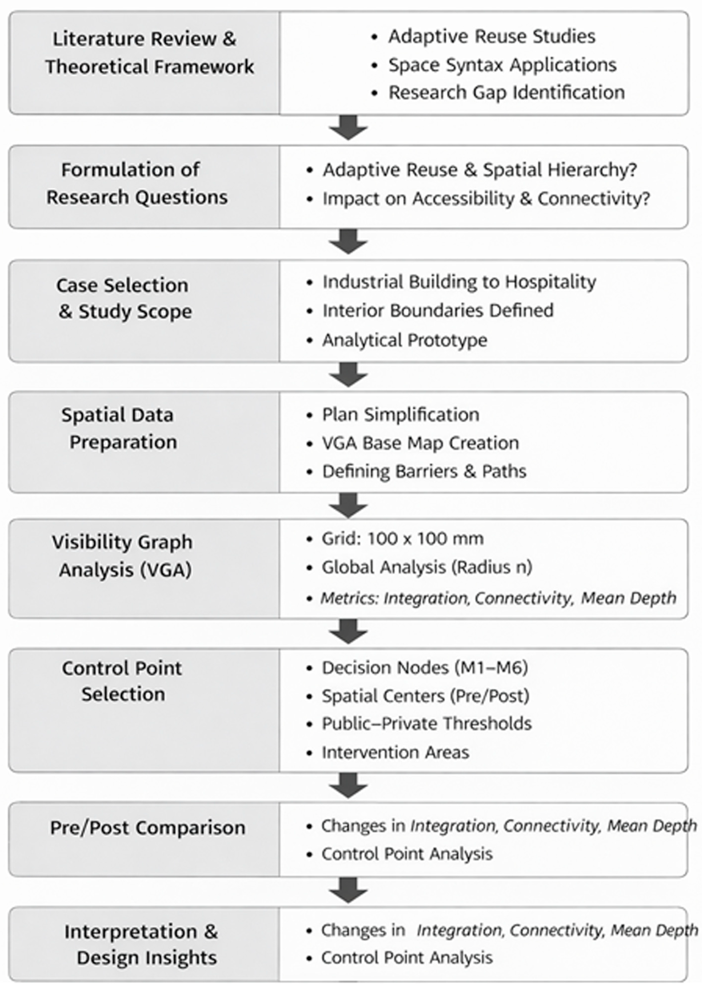
The methodology adopted in this study is structured as a multi-stage and systematic process, extending from the review of relevant literature to analytical evaluation. The research is grounded in an analytical protocol aimed at examining plan-level transformations in spatial hierarchy within the context of adaptive reuse. Accordingly, the selection of the case building, the preparation of spatial data, the execution of visibility-based configurational analyses, and the interpretation of the resulting findings in relation to plan organization and design decisions are addressed as sequential stages.
The overall methodological protocol and the analytical steps followed in the study are schematically summarized in
Figure 1. The presented workflow diagram illustrates that the spatial analyses are not treated as independent technical outputs, but are interpreted in direct relation to plan-level architectural interventions.
2.1. Case Building and Analytical Scope
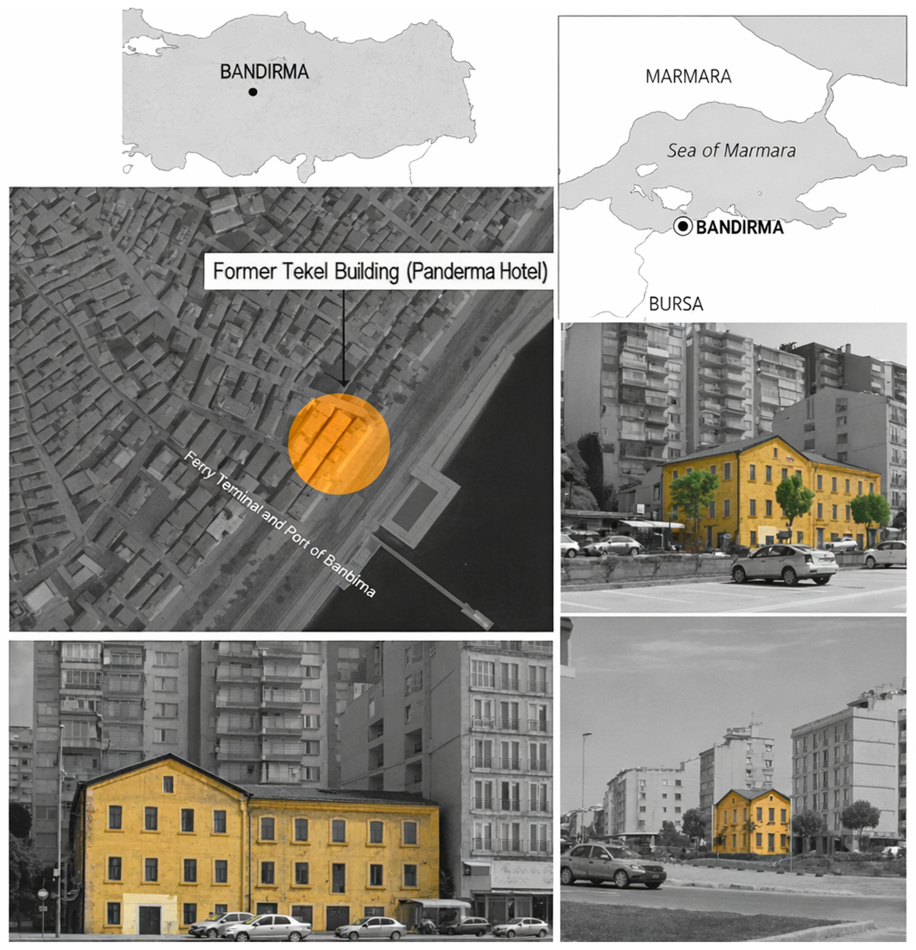
The building examined in this study is a former industrial structure located in the city center of Bandırma, directly connected to the port and ferry terminal, and situated within a dense urban fabric (
Figure 2). Currently reused as a hospitality facility, the building—through its relationship with the surrounding multi-storey residential context and transportation infrastructure—provides a suitable case for examining plan-level spatial transformations in the context of adaptive reuse. The urban context of the building is presented through the study area visualization, which situates the case at national, regional, and city scales while simultaneously illustrating its immediate surroundings and existing physical condition (
Figure 2). The building’s compact plan structure, limited number of floors, and absence of major structural alteration make it particularly suitable for isolating the effects of program-driven plan-level reconfiguration.
The building has an approximate gross floor area of 1593 m2 distributed across three levels. Following restoration and adaptive reuse, the ground floor accommodates a restaurant and associated kitchen facilities, a lobby and reception area, administrative offices, and sanitary units. The first and second floors each contain eleven guest rooms with en-suite bathroom facilities (22 rooms in total), together with floor-level service offices. An additional meeting room is located at the cihannüma level.
Vertical circulation is provided by a three-flight stair positioned along the south-eastern structural wall and an integrated elevator shaft, while access to the cihannüma level is achieved via a timber stair rising from the first floor. Technical units, including mechanical and generator rooms, are positioned externally at garden level to the south of the main building mass. No structural expansion or modification of the load-bearing system was undertaken; the building envelope and floor plate dimensions remained unchanged. These programmatic insertions were therefore accommodated within stable architectural boundaries, enabling controlled comparison of spatial configuration across pre- and post-intervention conditions.
In this context, the building is approached not as a representative example, but as an analytically bounded case condition that enables the examination of how plan-level decisions associated with programmatic transformation affect spatial hierarchy through before-and-after comparisons conducted within the same architectural boundaries. Accordingly, the analysis focuses on comparing pre- and post-intervention spatial configurations within identical architectural limits. This approach allows the observed configurational changes to be interpreted as outcomes related to program-driven architectural interventions rather than to differences in scale, context, or building footprint.
Although the building is situated within a dense urban environment, the analytical focus of the study is confined to interior spatial configuration. The urban context is considered as a background condition shaping programmatic requirements, while the primary objective of the study is defined as analytically examining how plan-level design interventions are associated with the reorganization of spatial hierarchy.
2.2. Visibility Graph Analysis
Spatial configuration was analyzed using visibility-based Space Syntax methods to examine changes in accessibility, connectivity, and depth relationships during the adaptive reuse process. At the building scale, Visibility Graph Analysis (VGA) was selected because it allows the representation of continuous visual fields and circulation potential within interior spaces at a detailed plan-level resolution. Foundational studies have documented the applicability of VGA in interpreting spatial configuration in relation to architectural use and movement [
25]. All visibility graph analyses were conducted using Syntax2D (S2D), version 1.3.0.7 (Space Syntax Laboratory, University College London, London, UK). Spatial models were generated from CAD-based floor plans. Architectural boundaries were defined based on load-bearing and fixed partition walls extracted from CAD-based drawings.
The visibility model was constructed based on primary enclosure geometry at the plan level. Structural columns were represented graphically in the plan but were not modelled as independent visibility barriers, as their scale did not substantially alter the global integration patterns of the visibility field. For modelling consistency, fixed structural walls and full-height permanent partitions were encoded as complete visibility barriers. Door openings were modelled as open thresholds where circulation was functionally permitted in the post-intervention condition and according to documented access conditions in the pre-intervention layout. Temporary furnishings, movable partitions, and non-structural elements below eye level were excluded from the visibility model. Inaccessible technical rooms, service shafts, and structurally enclosed voids were removed from the analytical grid. Visibility constraints were therefore defined strictly according to permanent architectural enclosure geometry at eye-level approximation, ensuring consistent barrier encoding across both temporal configurations. The analysis was conducted in two dimensions at the plan level, without incorporating vertical visual fields across floors. Under these consistent modelling assumptions, the magnitude of pre–post metric shifts should be interpreted in relation to visibility-field restructuring rather than as isolated numerical escalation. Because VGA integration values accumulate relational visibility across the entire grid system, the introduction or removal of spatial partitions, corridor alignments, and threshold openings can produce substantial changes in cumulative visibility relations. In grid-based VGA systems, minor topological changes may propagate system-wide integration effects due to the cumulative nature of relational visibility calculation. In the present study, all modelling assumptions—including boundary definitions, partition treatment, door openings, and grid parameters—were consistently applied across both temporal configurations. Therefore, the observed metric shifts reflect reorganization of visibility continuity and circulation structure rather than artefacts of modelling variation.
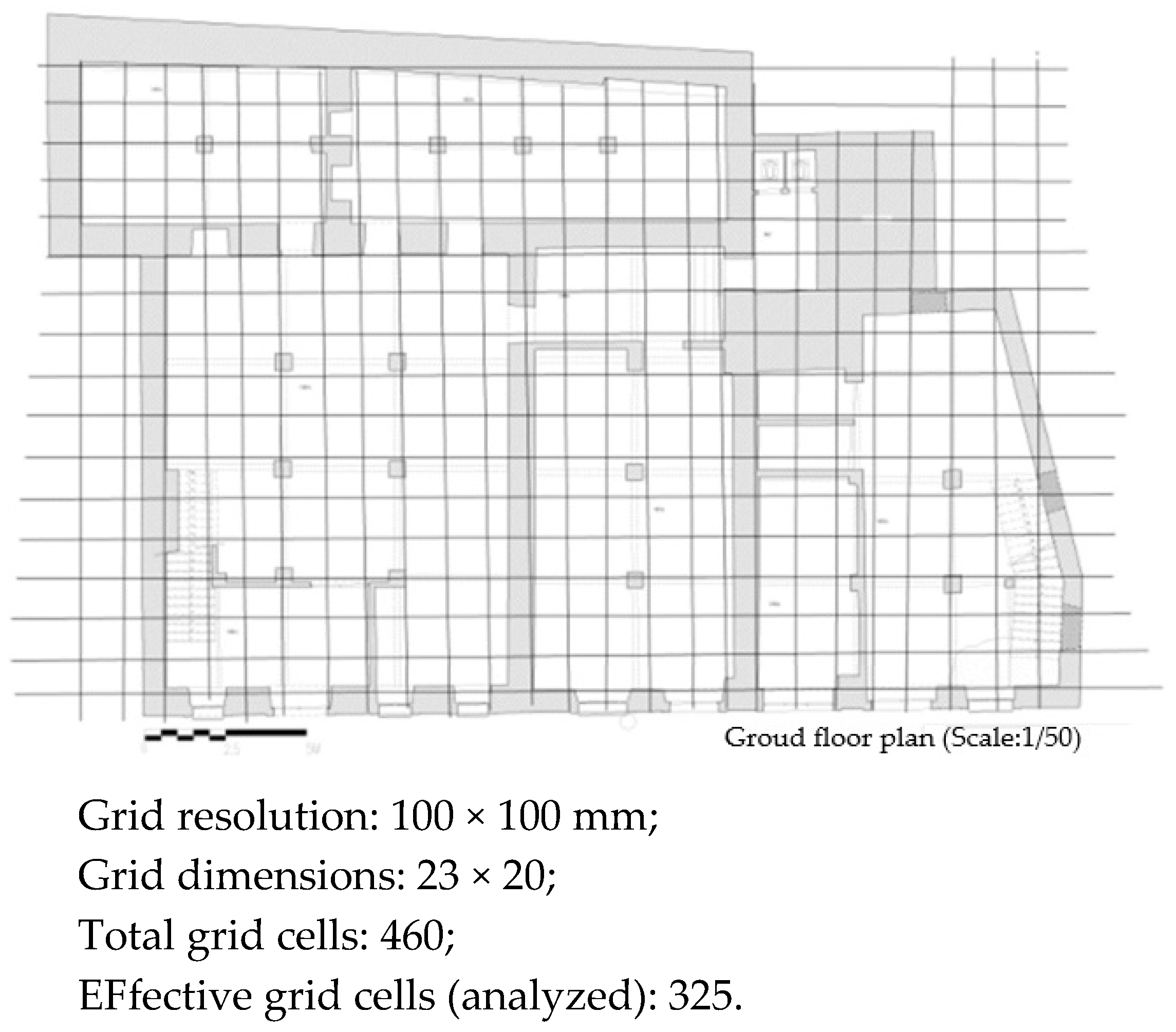
Grid-based visibility graphs were generated using a resolution of 100 × 100 mm (see
Appendix A,
Figure A1). This resolution was selected based on the interior spatial scale and circulation density of the building. A finer grid produces excessive fragmentation without significantly altering global integration patterns, whereas a coarser grid reduces spatial differentiation at the plan level. The 100 mm resolution therefore provides a balanced level of analytical sensitivity suitable for building-scale interior visibility analysis. On the ground floor, 460 grid cells were generated, of which 325 were included after excluding obstructed or inaccessible areas. Although the number of effective grid cells varied across floors due to plan geometry, identical grid resolution and analytical parameters were consistently applied across all floors and both pre- and post-intervention configurations to ensure methodological comparability. Preliminary tests conducted at 150 mm and 200 mm resolutions showed consistent directional patterns in global integration distribution, indicating that the selected 100 mm grid does not appear to artificially amplify configurational differentiation. These alternative resolutions did not alter the relative ranking of integration values across control points.
All analyses were conducted using a global VGA approach (radius = n), allowing each grid cell to be evaluated in relation to the entire spatial system. The primary syntactic measures employed were visual integration, connectivity, and mean depth. These measures are treated as relational indicators rather than normative performance metrics. All reported values are raw (non-normalized) measures, interpreted comparatively between pre- and post-intervention conditions within identical architectural boundaries. As the comparison is confined to a controlled single-case condition with consistent parameters, normalization procedures required for cross-case statistical comparison were methodologically unnecessary. To ensure methodological robustness and replicability, all analytical parameters—including grid resolution, boundary definitions, radius settings, and visibility computation procedures—were consistently maintained across all floors and both temporal conditions. The controlled application of identical settings allows direct configurational comparison without introducing analytical variability. This transparency ensures that the analytical procedure can be reproduced under equivalent spatial conditions. It should be noted that raw integration values obtained from VGA are sensitive to system size and grid density. As the analysis is confined to a controlled single-case condition with identical grid resolution, boundary definitions, and radius settings across pre- and post-intervention configurations, absolute magnitudes are not interpreted as independent indicators of spatial performance. Instead, the study focuses exclusively on relative directional shifts within the same spatial system. Therefore, high numerical values reflect cumulative visibility relations within the grid-based system rather than enabling direct cross-system comparison. This controlled analytical protocol ensures internal consistency while avoiding misleading inter-system interpretation. Because both temporal configurations share identical spatial boundaries and analytical parameters, normalization would proportionally rescale the values without altering the directional interpretation of configurational change. Preliminary normalization tests conducted on selected control points confirmed that proportional rescaling did not alter the sign or relative magnitude ranking of Δ Integration values across floors. For this reason, raw values were retained to preserve fine-grained relational differentiation within the same spatial system.
2.3. Selection of Control Points: Comparative Approach and Rationale
Instead of relying exclusively on system-wide statistical averages, the analysis adopts a comparative, design-oriented control-point-based approach. This method focuses on spatial nodes of architectural and functional significance that are associated with the transformation process, allowing plan-level changes to be examined in a more focused and interpretable manner.
The control points (M1–M6) were identified according to the following four explicit criteria:
Circulation decision nodes where users encounter directional choices or experience spatial transitions;
Locations representing spatial centrality in both pre- and post-intervention conditions, with functionally equivalent roles within the plan;
Threshold spaces between public, semi-public, and private zones, where changes in spatial hierarchy and access control become most evident;
Areas directly subjected to architectural intervention, including reconfigured circulation cores, redistributed program areas, and newly introduced spatial connectors.
These control points do not represent specific rooms or spaces, but rather critical relational nodes within the plan organization where spatial hierarchy is produced, directed, or transformed. Accordingly, they are treated not as discrete spatial units, but as analytical references where circulation, visibility, and access relationships are concentrated. By prioritising configurational significance over abstract statistical averages, this approach foregrounds design-driven spatial differentiation by examining where, how, and in which directions plan-level architectural decisions reshape spatial hierarchy during the adaptive reuse process.
The visual integration, connectivity, and mean depth values employed in this study are non-normalised (raw) syntactic measures. Rather than enabling inter-building comparisons based on absolute values, the analysis focuses on revealing relative configurational changes between pre- and post-intervention conditions within identical architectural boundaries. By comparing the same control points across both configurations, the analysis does not ask whether accessibility increases uniformly across the system, but instead identifies where and how spatial priorities are selectively intensified, maintained, or withdrawn through plan-level design decisions. In this way, the control-point-based approach foregrounds plan-level design decisions over statistical abstraction and supports a design-oriented analytical perspective for interpreting spatial hierarchy. While alternative nodes could theoretically be selected, the defined criteria ensure methodological transparency and configurational comparability. Each control point corresponds to a spatially and programmatically equivalent relational position across both temporal conditions, thereby minimizing arbitrariness in node selection. To test robustness, additional neighbouring grid cells within a 1.5 m radius of each defined control point and belonging to the same relational category were examined. The 1.5 m radius corresponds approximately to the average interpersonal circulation distance within the primary corridor widths observed in the case building, allowing robustness testing without extending into adjacent relational zones. These supplementary nodes showed consistent directional shifts in integration and mean depth values across pre- and post-intervention conditions, indicating that the findings are not solely dependent on isolated nodal selection. Vertical redistribution is not derived from direct comparison of absolute integration magnitudes across floors with differing system sizes or grid-cell counts; rather, it is interpreted through consistent intra-floor pre/post-directional shifts observed under identical analytical parameters. Because each floor maintains stable architectural boundaries across temporal states, redistribution is interpreted as a relative change in configurational intensity across levels, supported by cross-level directional contrast rather than numerical equivalence.
Accordingly, vertical differentiation is analytically grounded in intra-floor consistency combined with cross-level directional contrast. Cross-floor interpretation is therefore based on directional contrast rather than absolute equivalence of syntactic magnitude.
Table 1 summarises the functional and relational roles associated with each defined control point in both pre- and post-intervention configurations. Additional supporting visual material is provided in
Appendix A (
Figure A1).
3. Results
3.1. Comparative Analysis of Ground-Floor Spatial Configuration
The spatial configuration of the ground floor was examined through a controlled comparison of pre- and post-intervention conditions in order to identify how program-driven architectural interventions restructured accessibility and spatial hierarchy within the same architectural envelope. Visibility-based measures were not interpreted as isolated quantitative outputs, but as indicators of how configurational centrality and circulation logic were redefined through plan-level decisions.
In the pre-intervention configuration, integration values exhibit a relatively constrained distribution, with centrality concentrated in limited interior zones and without a clearly articulated public circulation axis. The spatial hierarchy appears comparatively diffuse, with no dominant configurational spine organizing movement and visual relationships.
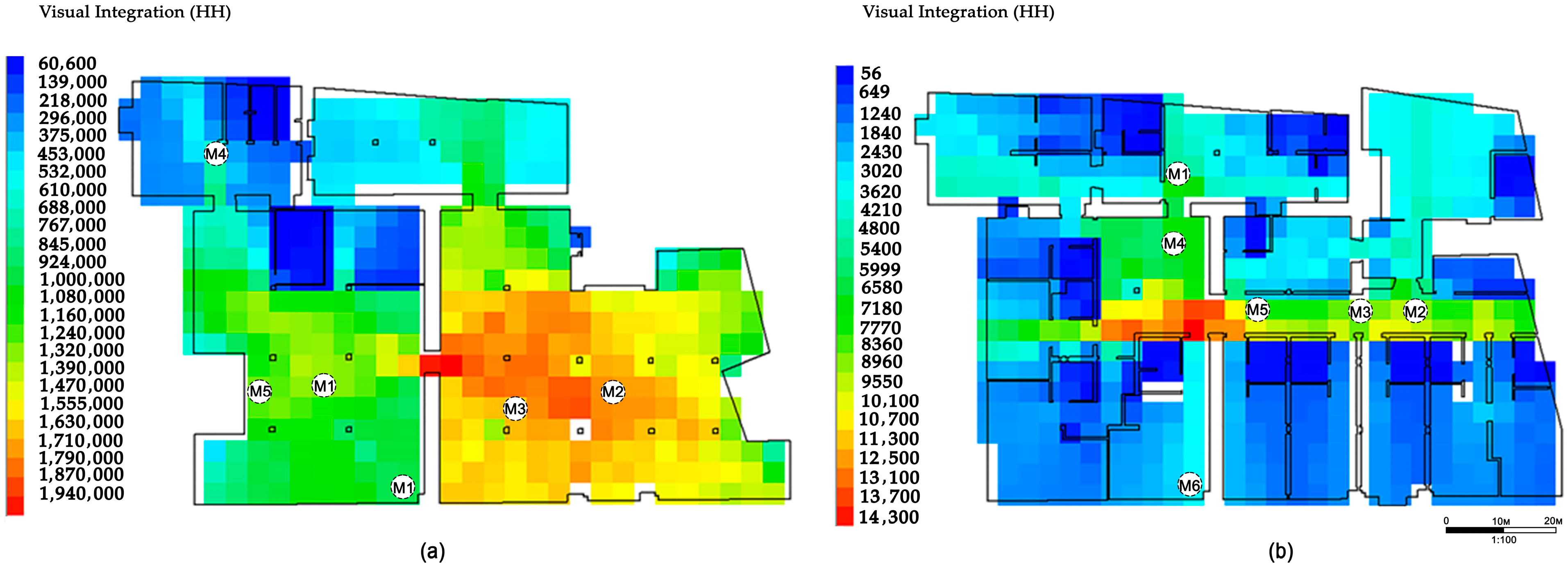
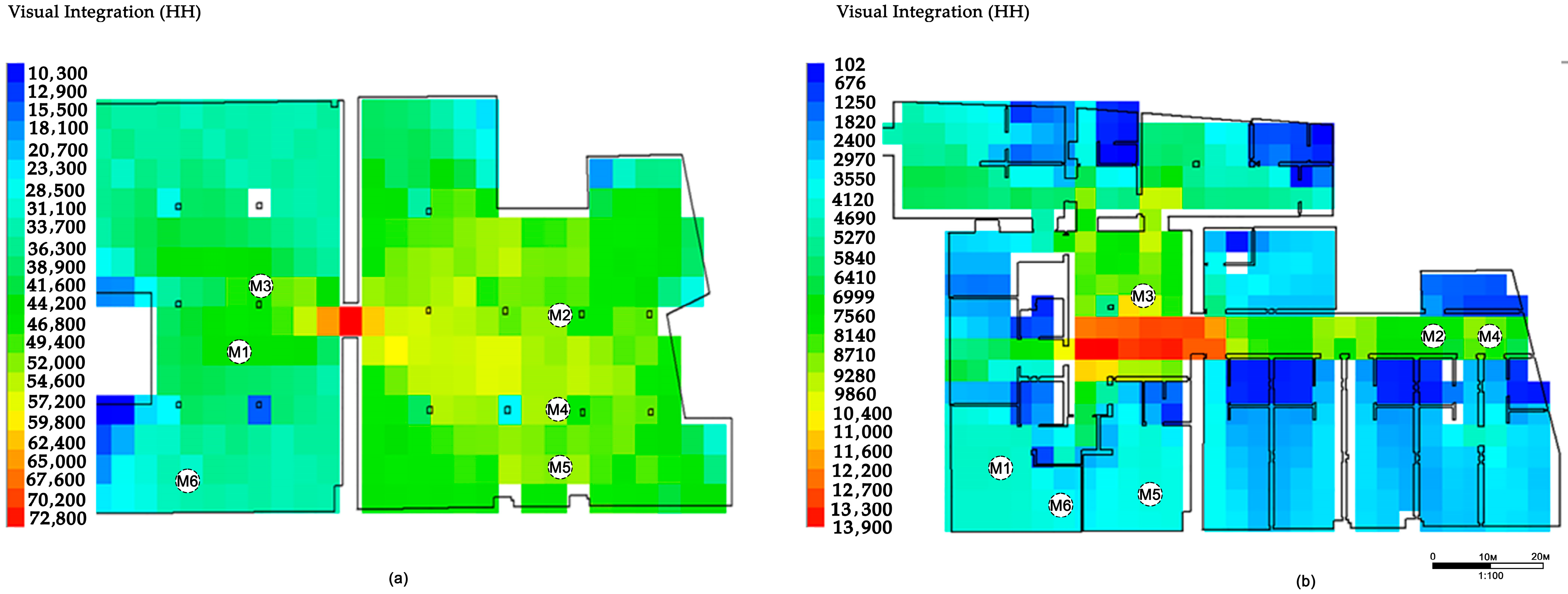
Following the adaptive reuse intervention, the redistribution of visual integration on the ground floor does not manifest as a uniform amplification of accessibility, but as a spatial reorientation of centrality toward newly defined movement corridors and publicly accessible areas (
Figure 3b). Integration values increase particularly along reconfigured circulation axes and spatial connectors introduced through the hospitality program. This pattern suggests selective recalibration of spatial hierarchy through the restructuring of primary movement paths rather than uniform strengthening across the entire floor.
Figure 3b shows a clear intensification of integration values concentrated around the newly introduced circulation nodes, indicating that program-driven restructuring has selectively amplified configurational centrality at the ground floor.
Warmer colors indicate higher visual integration values (greater configurational centrality), while cooler colors represent lower integration and increased spatial segregation. Black squares denote control points (M1–M6), defined according to explicit methodological criteria to enable controlled comparison between pre- and post-intervention conditions, while N1 denotes the primary circulation node used as a reference point in the configurational analysis. Color gradients represent the relative range of integration values within each configuration. Color scales are adjusted independently to reflect the respective value distributions of the pre- and post-intervention ground-floor layouts.
Connectivity values further support this interpretation. While the pre-intervention condition exhibits fragmented visual fields and limited relational continuity between spaces, the post-intervention configuration exhibits strengthened visual linkages within principal circulation zones. Rather than reflecting a simple increase in connections, this shift suggests a consolidation of visual fields along primary circulation paths, contributing to the legibility of public access areas.
Mean depth values provide additional evidence of hierarchical restructuring. In the pre-intervention configuration, even publicly accessible zones exhibit relatively elevated depth values, indicating a lack of clear spatial prioritisation. In contrast, the post-intervention condition shows reduced depth within primary public areas and increased depth within service and controlled-use zones. The increase in mean depth at controlled nodes such as M5 (from 2.23 to 4.58) further illustrates the increased relational distance observed in service-oriented zones, reinforcing vertical and horizontal segregation patterns within the same spatial envelope.
The comparative evaluation of control points (M1–M6), presented in
Table 2, indicates that spatial transformation is concentrated at nodal locations rather than occurring homogeneously across the system. The magnitude and directionality of integration shifts—most notably the substantial amplification at M4 (+19,649.17) and the pronounced withdrawal at M5 (−7258.89)—indicate that hierarchical redistribution is asymmetrically concentrated at defined circulation nodes. These magnitudes should be interpreted relative to the baseline visibility continuity of the pre-intervention configuration, rather than as absolute performance indicators. Accordingly, the observed shifts reflect spatially differentiated redistribution at specific circulation nodes rather than uniform functional reassignment.
3.2. Upper Floors: Configurational Contraction and Differentiation
While the ground floor exhibits a redistribution and expansion of configurational centrality, the upper floors exhibit a contrasting spatial logic characterised by increased compression of accessibility fields. The comparative analysis of pre- and post-intervention conditions suggests not a uniform reduction in spatial quality, but a measurable recalibration of hierarchical depth associated with program-specific privacy requirements.
3.2.1. First Floor
In the pre-intervention configuration, integration values on the first floor display a dispersed pattern, with several nodes exhibiting relatively high accessibility despite the absence of a clearly articulated functional hierarchy. This distribution suggests a spatial system that, although not strongly centralised, does not yet differentiate between primary and secondary zones in a programmatically defined manner.
In the post-intervention condition, the reduction in integration and connectivity values should not be interpreted as configurational weakening. Rather, the redistribution reflects a deliberate contraction of circulation fields and a redefinition of spatial thresholds. Accessibility becomes selectively limited to functionally necessary paths, while peripheral zones exhibit increased depth and segregation.
Figure 4b demonstrates a measurable contraction of high-integration zones and an increase in mean depth values at defined control points, indicating a more segregated and selectively structured configurational regime at the upper levels.
Warmer colours indicate higher levels of visual integration and greater configurational centrality, whereas cooler tones represent lower integration and increased spatial segregation. Control points M1–M6 identify spatially and functionally comparable relational nodes across both temporal conditions, selected in accordance with defined methodological criteria. The post-intervention configuration shows contraction of visibility fields and increased configurational differentiation relative to the pre-intervention condition. All colour gradients represent relative integration values within the analyzed floor and are interpreted comparatively between pre- and post-intervention conditions.
The substantial and asymmetrical decreases in integration at all defined control points (
Table 3)—most notably at M2 (−32,803.79) and M3 (−32,346.19)—indicate pronounced contraction of configurational centrality across the first floor. These magnitudes should be interpreted relative to the baseline visibility continuity of the undivided pre-intervention industrial layout, rather than as absolute performance indicators. The concurrent increase in mean depth across control points further reinforces this containment pattern, indicating that spatial nodes become configurationally more distant within the global visibility network. This measurable deepening of relational distance complements the reduction in integration values and suggests that hierarchical differentiation emerges through systematic configurational withdrawal rather than incidental programmatic reassignment.
3.2.2. Second Floor
The second floor exhibits a substantial reduction in visual integration across the defined control points following intervention. In the pre-intervention configuration, relatively high integration values at certain nodes correspond to an undivided spatial structure, where visibility fields extend across the floor with limited corridor segmentation.
Warmer colours indicate higher visual integration and greater configurational centrality, while cooler colours indicate lower integration and increased spatial segregation. Control points M1–M6 correspond to analytically defined relational nodes selected according to explicit methodological criteria. The post-intervention configuration shows reduced integration and shortened visibility fields relative to the pre-intervention condition. All colour gradients represent relative integration values within each analyzed floor.
Following intervention, integration and connectivity values decrease substantially across all defined control points (
Table 4), with integration reductions exceeding −40,000 at several nodes (e.g., M1, M2, M4, M5). These shifts indicate marked contraction of configurational centrality across the second floor. The magnitude of Δ Integration values should be interpreted relative to the baseline visibility continuity and overall system size of the undivided pre-intervention configuration, in which extended visibility fields produced elevated integration values. The introduction of corridor segmentation and compartmentalisation consequently generated proportionally large reductions. Concurrent increases in mean depth—most notably at M1 (1.51 to 4.29) and M5 (1.49 to 3.81)—further reinforce this containment pattern, demonstrating measurable relational distancing within the global visibility network.
The consistency and magnitude of decreased integration combined with increased mean depth across all control points suggest that the second floor exhibits a distinct pattern of hierarchical containment.
Figure 5b makes this containment regime visually explicit, showing the contraction of high-integration zones and the shortening of visibility fields across the post-intervention configuration. Unlike the selective amplification observed on the ground floor, the second floor exhibits systematic reduction in relational accessibility, producing a vertically differentiated hierarchy within identical architectural boundaries.
4. Discussion
This study does not seek to establish direct empirical correlations between syntactic measures and observed user behavior. Instead, VGA is employed as an interpretive configurational tool for examining plan-level spatial restructuring. The interpretations presented here therefore concern configurational potential rather than empirically verified behavioral performance. Future validation may involve short-term observational movement sampling or circulation trace mapping aligned with control points M1–M6, enabling systematic comparison between syntactic intensification and observed movement concentration within identical spatial boundaries.
The contribution of this study lies not in confirming intuitive public–private distributions, but in analytically tracing the configurational mechanisms through which adaptive reuse restructures spatial hierarchy within identical architectural boundaries. Previous research has frequently approached adaptive reuse from strategic, economic, or feasibility-oriented perspectives [
26], emphasizing decision-making frameworks and performance assessment at the building or urban scale. While such approaches are essential for evaluating adaptive reuse potential, they typically do not examine how plan-level architectural interventions reconfigure spatial hierarchy within the existing envelope.
The present study complements these strategic assessments by introducing a configurational reading that links design decisions to measurable hierarchical redistribution. By isolating plan-level design interventions under controlled conditions, the findings suggest that spatial transformation operates through measurable recalibration of visibility fields, circulation axes, and nodal centrality. Within this framework, adaptive reuse can be understood not merely as functional substitution, but as a structured reorganization of spatial hierarchy at the plan level.
4.1. Redistribution of Spatial Hierarchy
The comparative analysis suggests that adaptive reuse does not dissolve existing hierarchies but recalibrates them rather than replacing them entirely. Such recalibration aligns with configurational theory, which suggests that spatial hierarchy emerges through relational restructuring within a system rather than through simple functional reassignment [
13,
16].
This redistribution becomes visible in the differential behavior of defined control points, where shifts in integration and connectivity values indicate selective amplification of certain relational nodes and compression of others. Rather than uniformly increasing accessibility across the system, the post-intervention configuration exhibits intensified configurational centrality in specific circulation corridors while reducing relational exposure in more controlled zones.
By tracing these shifts at identical control points under consistent analytical parameters, the study moves beyond descriptive accessibility comparison and examines how hierarchical differentiation emerges through plan-level design decisions. In this respect, the contribution lies in revealing the configurational mechanisms that produce hierarchical redistribution within a fixed spatial envelope, rather than merely confirming anticipated public–private gradients.
While recent studies have proposed computational and grammar-based methods to generate alternative spatial layouts in adaptive reuse contexts [
26], the present study differs by examining how spatial hierarchy is restructured within an already implemented intervention. Rather than producing design alternatives, the analysis focuses on tracing configurational redistribution within a fixed architectural envelope, thereby linking plan-level design decisions to measurable hierarchical outcomes.
Notably, the magnitude and directional contrast of integration shifts across control points indicate that the observed redistribution cannot be fully explained by functional reassignment alone; rather, it reflects measurable recalibration of relational intensity within the existing spatial envelope.
On the ground floor in particular, integration does not increase uniformly across all control points. Instead, configurational intensity is redistributed unevenly: while specific circulation nodes (e.g., M4 and M6) experience substantial amplification, others (e.g., M3 and M5) undergo pronounced withdrawal. This uneven directional pattern suggests that spatial hierarchy is not globally strengthened but selectively restructured. The coexistence of intensified and reduced integration values within the same floor therefore supports the interpretation of adaptive reuse as a process of differentiated hierarchical reorganization rather than homogeneous centralization.
4.2. Ground-Floor Centralisation
The concentration of integration and connectivity values on the ground floor reflects not an automatic programmatic necessity but a measurable configurational restructuring that redefines the ground floor as the dominant relational plane of the building. In particular, the intensified integration values observed at key circulation control points indicate measurable extension of visibility fields and reinforcement of nodal centrality along newly structured movement axes.
This suggests that centrality in adaptive reuse contexts is not inherent to level position but emerges through plan-level recalibration of circulation paths and visual continuity. Accordingly, the ground floor functions as the primary locus of configurational centrality, where movement fields expand and central nodes exhibit increased integration under controlled boundary conditions.
The mixed Δ Integration values observed at the ground-floor control points further confirm that centrality is redistributed asymmetrically, concentrating relational intensity along newly defined circulation spines while selectively withdrawing it from service-oriented or controlled nodes.
This supports a reading of adaptive reuse as a process of horizontal expansion of centrality rather than uniform enhancement of spatial integration.
4.3. Upper Floors—Vertical Hierarchical Compression
The upper floors exhibit a contrasting configurational pattern characterised by measurable contraction of visibility fields and increased mean depth values at defined control points. Rather than indicating diminished spatial quality, this compression corresponds to a structured vertical gradient in which accessibility is reduced in relation to program-specific thresholds.
In particular, the reduction in integration and connectivity values across upper-floor circulation nodes corresponds to increased containment of visibility and movement fields that differentiates private or semi-private zones from the centralised ground-floor configuration. Increased relational depth has similarly been associated with mechanisms of spatial control and privacy differentiation in building-scale configurational analyses [
16,
20]. This vertical differentiation suggests that spatial hierarchy in adaptive reuse is redistributed through both expansion and containment processes.
In contrast to the asymmetrical redistribution observed on the ground floor, the upper levels demonstrate a consistent directional shift toward increased relational depth and reduced integration across control points, indicating systematic hierarchical containment rather than selective amplification.
While the ground floor centralises configurational intensity, the upper floors exhibit hierarchy through greater configurational segregation under identical boundary conditions. These findings suggest a differentiated spatial pattern characterised by horizontal intensification and vertical compression. The significance of the findings lies not in confirming functional expectations, but in quantifying the magnitude and patterned directionality of configurational shifts that are otherwise assumed but rarely measured.
5. Conclusions
This study provides a controlled configurational analysis of adaptive reuse as a process of restructuring spatial hierarchy within a fixed architectural envelope, rather than merely reassigning functional categories. By conducting controlled pre- and post-intervention comparisons within identical architectural boundaries, the research isolates program-driven plan-level design decisions as the primary factor associated with measurable shifts in integration, connectivity, and spatial depth.
The findings suggest that spatial transformation cannot be fully explained by an intuitive public–private gradient alone. On the ground floor, integration and connectivity values intensify along redefined circulation axes, while upper floors exhibit measurable contraction of visibility fields and increased relational depth. The magnitude and patterned distribution of these shifts indicate a systematic configurational recalibration rather than automatic programmatic realignment. Within the examined case, adaptive reuse therefore operates as a reconfiguration of spatial hierarchy rather than merely as a reassignment of functions.
Methodologically, the study demonstrates that visibility-based Space Syntax analysis can function as a design-oriented interpretive tool when applied under controlled boundary conditions. Rather than pursuing statistical generalisation, the proposed approach traces configurational mechanisms within a fixed spatial envelope, linking quantitative outputs to architectural decisions within the analysed configuration. The findings concern configurational potential rather than empirically verified behavioral outcomes.
While confined to a controlled single-case condition, the contribution of the study lies in articulating a case-bound analytical framework for systematically examining configurational change within stable architectural boundaries. The analytical protocol should therefore be interpreted in relation to comparable spatial conditions rather than as a universally transferable model. Such conditions include: (i) stable architectural boundaries that allow controlled comparison, (ii) significant program transformation requiring plan-level reorganization, and (iii) spatial configurations in which circulation and visibility play a central role in functional differentiation.
While cultural and contextual factors may influence program priorities and user behavior, the configurational mechanisms identified here relate primarily to plan-level spatial reorganization rather than to culturally specific design outcomes. Accordingly, the study offers a structured analytical perspective for examining similar processes in adaptive reuse contexts where comparable spatial and circulation conditions can be clearly identified.
In applying the protocol to other cases, several methodological assumptions and potential adjustments should be explicitly considered. The approach is most suitable for building types with relatively continuous interior layouts—such as industrial, commercial, or institutional structures—where visibility fields meaningfully reflect relational hierarchy. In highly cellular residential plans or fragmented heritage interiors, grid resolution and control-point definition may require recalibration to preserve analytical consistency. Normalization of integration values may also become necessary when comparing buildings of substantially different spatial scales or when system size varies between temporal conditions. Additionally, adjustments to boundary definitions and analytical radius parameters may be required where vertical circulation cores or structural segmentation patterns differ significantly. Under such clearly defined modeling conditions, the protocol offers a structured means of examining how architectural interventions influence relational hierarchies.