Article

Integrating the SBE–SD Method and Eye-Tracking Analysis for Evaluating Visual Experience in Traditional Village Heritage Landscapes


1
College of Architecture and Civil Engineering, West Anhui University, Lu’an 237012, China
2
School of Architecture, Southeast University, Nanjing 210018, China
3
Graduate School of Environmental Engineering, The University of Kitakyushu, Kitakyushu 808-0135, Japan
4
School of Foreign Languages, Hefei Normal University, Hefei 230061, China
5
School of Architecture and Planning, Anhui Jianzhu University, Hefei 230601, China
*
Author to whom correspondence should be addressed.
Buildings 2026, 16(18), 3747; https://doi.org/10.3390/buildings16183747 (registering DOI)
Submission received: 26 July 2026 / Revised: 5 September 2026 / Accepted: 8 September 2026 / Published: 20 September 2026
(This article belongs to the Section Architectural Design, Urban Science, and Real Estate)

Abstract

Rapid urbanization has posed significant challenges to the conservation and sustainable management of heritage landscapes. This study integrates the Scenic Beauty Estimation–Semantic Differential (SBE–SD) method with eye-tracking (ET) analysis to establish a subjective–objective framework for evaluating visual experiences in heritage landscapes, using the traditional villages of Hongcun and Xidi in Anhui Province, China, as case studies. A total of 117 participants completed the eye-tracking experiment, while 374 respondents with varied demographic and prior-visitation backgrounds participated in the SBE–SD questionnaire survey based on 28 representative landscape photographs. The results indicate that different landscape types exhibit distinct eye-tracking characteristics, with visual attention primarily concentrated on dominant architectural structures and visually salient landscape elements. Significant associations were identified between subjective visual quality evaluations and ET indicators, particularly fixation frequency (FF) and proportion of fixation duration (PFD). Associations were also observed between landscape perception dimensions and visual attention metrics, highlighting the relationship between perceived landscape characteristics and gaze behavior. The correspondence between ET results and SBE–SD evaluations supports the value of integrating subjective and objective approaches in heritage landscape assessment. Overall, the findings demonstrate the potential of eye-tracking as a complementary quantitative approach for understanding the visual quality of traditional village landscapes and provide practical implications for heritage conservation and landscape planning.

1. Introduction

1.1. Background

In contrast to modern cities, traditional villages have abundant cultural heritage resources. With a long history, they constitute a key driving force for promoting sustainable development in rural areas [1]. As China promotes integrated urban–rural development as an important national strategy, rural landscapes play an essential role by delivering multiple ecosystem services, including the enhancement of psychological and physical well-being [2,3]. The visual and sensory pleasure of rural landscapes can be effective in alleviating the mental stress of local residents and travelers, offering opportunities to escape from urban environmental stressors [4,5]. However, in the context of rapid urbanization, traditional villages continue to face significant development pressures. Under market-oriented economic conditions, real estate expansion and infrastructure construction have, in some cases, led to excessive development, posing challenges to the preservation of historic spatial patterns and cultural landscapes. This situation highlights the urgent need for balanced protection and sustainable management strategies. At the same time, high-quality landscape environments not only enhance esthetic experience and tourism attractiveness but also function as important platforms for facilitating urban–rural exchange of information, resources, and cultural values. The classification of traditional landscape types varies but is mainly categorized as cultural landscapes, farmland landscapes, artificial landscapes, and natural landscapes [6,7]. As rural tourism has gained popularity, the landscape space of traditional villages has emerged as a key element in attracting tourists. The characteristics of traditional rural settlements are patterns shaped by a specific human environment, natural environment, ecological environment, and cultural context, and have typical external physical features [8]. Currently, traditional village landscapes face a series of challenges. During the rapid development of urban areas, county towns, and rural regions, increasing discrepancies have emerged between contemporary construction styles and the historical landscape characteristics of ancient villages. Settlement patterns inherited from the agricultural era have become increasingly difficult to preserve, and some villages have gradually lost their distinctive regional identities due to environmental and socio-economic changes [9]. Therefore, traditional villages must not only resist the homogenization of landscape characteristics but also preserve unique regional features that enhance public visual preference and cultural identity.

1.2. Literature Review

Scholars have primarily focused on traditional village studies, particularly heritage conservation, landscape planning, and tourism development [10]. Since the 1970s, research on traditional villages has become increasingly interdisciplinary, drawing on architecture, landscape ecology, urban and rural planning, history, and geography [11]. Most existing studies employ questionnaire surveys, field observations, the Analytic Hierarchy Process (AHP), and expert evaluations to assess landscape esthetics and cultural values. However, the integration of objective behavioral evidence remains relatively limited. From a spatial perspective, previous studies have mainly focused on three aspects: spatial distribution, evolutionary characteristics, and influencing factors. Using GIS-based methods, researchers have examined the spatial patterns of traditional villages across different historical periods, summarized their evolutionary characteristics, and explored the natural and socio-cultural factors influencing their development [8]. In recent years, scholars have increasingly applied advanced digital technologies, including UAV oblique photogrammetry and GIS-based remote sensing, to investigate traditional village landscapes. Attention has also gradually shifted toward human perception and behavioral responses. For example, Luo et al. [12] evaluated the effects of six social, demographic, and health-related factors and seven accessibility-related factors on preferences for visual and auditory elements in rural environments.
Eye-tracking (ET) technology records eye-movement behaviors, such as fixations, saccades, and pupil responses, in real time during visual observation, providing a quantitative approach for investigating visual attention and cognitive processes. In recent years, ET has been widely applied in medicine, education, transportation, human–computer interaction, advertising design, user experience, and environmental psychology [4,13]. Subsequently, it has been gradually introduced into geography, tourism, and landscape research [4,14,15]. In the field of landscape evaluation, ET data have increasingly been used to quantify visual preferences and provide quantitative evidence for landscape assessment and design. Previous studies have demonstrated that ET indicators, such as fixation frequency (FF) and proportion of fixation duration (PFD), can effectively reflect visual attention toward landscape elements [1]. For example, Zhang et al. [16] combined Scenic Beauty Estimation (SBE) with ET analysis and found that forest park landscapes exhibited relatively high visual quality, while also confirming the reliability of ET data for landscape evaluation. Similarly, Su et al. [15] investigated user preferences for rural public-space landscapes using ET techniques. Furthermore, ET has frequently been integrated with subjective questionnaires and physiological indicators, including heart rate, electroencephalography (EEG), and skin conductance, to enhance the reliability of research findings. Goto et al. [17] reported that Japanese garden landscapes elicited longer fixation durations and greater reductions in heart rate, suggesting that complex natural environments may provide stronger restorative benefits. Zhang et al. [18] further demonstrated that audiovisual interactions enhanced the restorative effects of forest park environments and that changes in pupil diameter were significantly associated with reductions in anxiety levels. Despite these advances, the application of ET technology in vernacular architecture and architectural heritage research remains relatively limited. Existing studies have primarily focused on landscape visual quality, visual preference, and restorative environments in natural settings such as forests, nature reserves, and waterfront landscapes. In contrast, research investigating the visual quality and perceptual characteristics of cultural heritage landscapes (CHLs), particularly traditional village landscapes, remains insufficient.
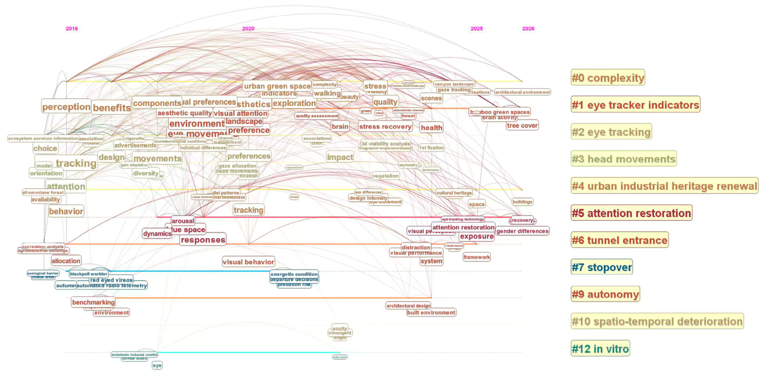
On 20 May 2026, the Web of Science Core Collection was searched to retrieve publications related to eye-tracking and landscape perception research. The search query included terms such as “eye tracking”, “visual preference”, “landscape perception”, “visual attention”, and “environmental esthetics”. Document types were limited to Articles, Proceedings Papers, and Early Access, yielding a total of 304 records. The dataset was subsequently imported into CiteSpace (Version 6.4.R1) for bibliometric visualization analysis. The node type was set to Keywords, and the analysis covered the period from 2016 to May 2026 with one-year time slices. Pathfinder and Pruning Sliced Networks were applied as pruning methods, and the Log-Likelihood Ratio (LLR) algorithm was used for cluster extraction. As shown in Figure 1 and Figure 2, the keyword co-occurrence network highlights eye tracking, visual preferences, perception, attention, landscape, esthetics, and behavior as the most prominent research themes, indicating growing interest in the relationships among visual attention, environmental perception, and landscape evaluation. The timeline visualization further reveals several major research clusters, including complexity, eye-tracking indicators, head movements, urban industrial heritage renewal, and attention restoration. Since 2020, research attention has gradually shifted from basic eye-movement measurements toward cognitive perception, environmental esthetics, landscape preference, and heritage-related studies. Overall, these findings demonstrate that eye-tracking technology has become an important quantitative research tool for investigating visual preference mechanisms, environmental perception processes, and esthetic evaluation in landscape and heritage studies.
This study investigates the traditional villages of Hongcun and Xidi from the perspective of public perception, with the aim of examining the relationships between heritage landscape characteristics, visual attention, and landscape evaluation. Although eye-tracking technology has been widely applied in environmental perception and landscape research, its application in traditional village heritage studies remains limited. By integrating eye-tracking (ET) analysis with the Scenic Beauty Estimation–Semantic Differential (SBE–SD) approach, this study establishes a combined subjective–objective evaluation framework for traditional village heritage landscapes. The findings contribute to a better understanding of visual preference mechanisms and provide quantitative evidence for heritage conservation and landscape planning.

2. Materials and Methods

2.1. Study Area

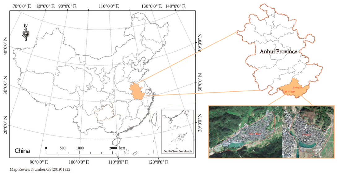
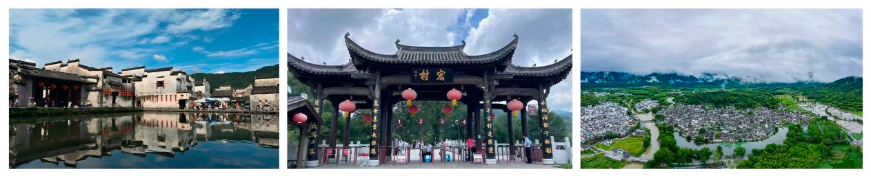
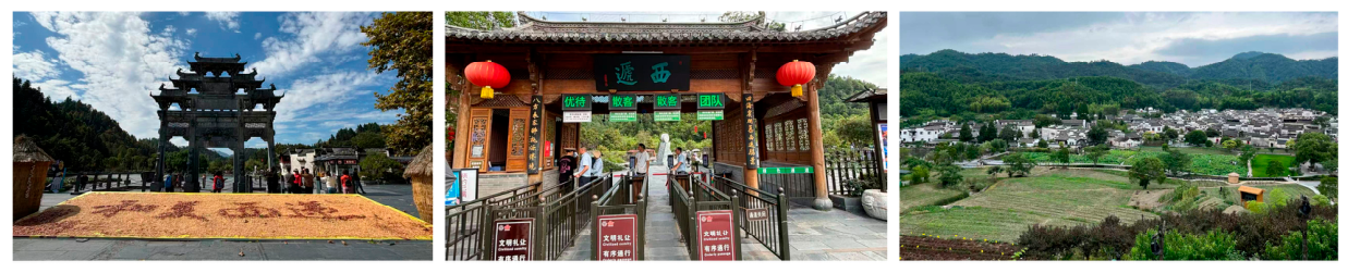
This study focuses on Hongcun and Xidi, two representative traditional villages located in Huangshan City, Anhui Province, China. Renowned for their distinctive Hui-style architecture and cultural landscapes, both villages were inscribed on the UNESCO World Heritage List in 2000 (Figure 3, Figure 4 and Figure 5). They are among the first National Historic and Cultural Villages of China, key national cultural heritage protection units, and National 5A Tourist Attractions. Often described as villages depicted in traditional Chinese landscape paintings, Hongcun and Xidi are characterized by white walls, black-tiled roofs, and well-preserved landscape features such as South Lake and Moon Pond. Surrounded by mountains and interconnected water systems, the villages represent a well-preserved traditional rural environment and attract numerous domestic and international visitors each year. Originating from the Song Dynasty and further developed during the Ming and Qing dynasties, the villages are widely recognized for their distinctive site selection, spatial organization, and water management systems.
For this study, 28 representative photographs were selected from the protected areas of the two villages [9]. The photographs were subsequently classified into four principal landscape categories: farmland landscapes, natural landscapes, cultural landscapes, and artificial landscapes.

2.2. Experimental Data Collection

2.2.1. Experimental Procedures and Operation Steps

This study employed eye-tracking (ET) technology, a non-invasive method that records eye movements and gaze behavior in real time and objectively quantifies visual attention through fixation and saccade metrics. Representative landscape images were selected for the experimental analysis. The participants were individuals of different ages, occupations, and cultural backgrounds. During the experiment, data such as fixation points, fixation times, and the areas of interest were recorded to assess the visual preferences associated with different landscape elements.

2.2.2. Data Collection and Participants

A three-round expert screening and consultation process was conducted to select representative landscape photographs. A total of 20 experts participated, including 10 architectural designers and 10 landscape planning scholars, all with more than 10 years of professional or research experience in architecture, landscape architecture, heritage conservation, or rural planning. In each round, experts independently evaluated the candidate photographs based on landscape representativeness, visual clarity, and category coverage. Feedback from each round was incorporated into the subsequent screening process, and disagreements were addressed through further expert consultation. Initially, more than 200 landscape photographs were collected from the core landscape areas of Hongcun and Xidi. Following three rounds of expert screening and evaluation, 28 representative photographs were retained for the experiment. These images were classified into four landscape categories: farmland landscapes (F), natural landscapes (N), cultural landscapes (C), and artificial landscapes (A). The selected photographs were intended to capture both the characteristic esthetic qualities and the typical visual and spatial features of each landscape category, while avoiding an overrepresentation of exceptionally attractive or visually extreme scenes. To facilitate subsequent analysis, all photographs were coded using the abbreviations F, N, C, and A, followed by numerical identifiers corresponding to individual scenes (Table 1).
The photographs used in this study were collected between June 2024 and October 2024 using an iPhone 15 Pro smartphone (Apple Inc., Cupertino, CA, USA). The device was used solely for image acquisition and provided sufficient clarity and resolution for standardized presentation in the eye-tracking experiment. Smartphone performance was not treated as an experimental variable, and no AI-based image-recognition tools (e.g., Google Lens) were used during image acquisition or analysis. The same smartphone was used throughout image acquisition to minimize device-related variation. Most images were captured during summer and autumn under stable daylight conditions, primarily between 09:00–12:30 and 15:00–18:30, in order to avoid extreme lighting conditions and maintain relatively consistent illumination. To reduce the influence of irrelevant environmental variables, photographs taken under foggy, hazy, rainy, overcast, or nighttime conditions were excluded. In addition, excessive pedestrian activity and visual obstruction were avoided whenever possible, except in unavoidable public landscape scenes. No season-specific color correction or artificial enhancement was applied, as the photographs were intended to retain the natural visual characteristics of the village landscapes. To minimize non-seasonal variation, images taken under extreme lighting, adverse weather, or visual obstruction were excluded. Because season was not predefined or balanced as an experimental factor, a post hoc summer–autumn comparison was not conducted, as it could confound seasonal effects with differences in landscape category and scene composition. During image acquisition, the camera lens was generally maintained at approximately 1.5–1.7 m above ground level, representing the typical eye height of a standing adult. Similar focal lengths and viewing angles were adopted to ensure consistency in spatial composition and visual presentation. All photographs were standardized to a 16:9 aspect ratio and resized to the same resolution before presentation. Representative landscape scenes were further verified through consultation with local residents and visitors to ensure the diversity and representativeness of the samples. Previous studies have shown that photograph-based evaluations can provide useful representations of landscape preference; however, static images cannot fully reproduce the dynamic and multisensory experience of on-site landscape perception [19,20].
The eye-tracking (ET) experiment was conducted in a controlled laboratory environment under standardized indoor lighting conditions. A total of 117 participants completed the eye-tracking experiment, whereas 374 respondents (Table 2), including local residents, tourists, university students, and academic experts, participated in the SBE and SD questionnaire survey. All participants had normal or corrected-to-normal vision and self-reported no color vision deficiency or eye disease. No clinical health examination was conducted before the experiment; therefore, unmeasured conditions such as fatigue or stress may have introduced some variability into the eye-tracking results. Eye movements were recorded using a Tobii Pro X3-120 eye tracker (120 Hz) mounted below a 21-inch monitor. Prior to data collection, a standard nine-point calibration procedure was performed for each participant. The 28 landscape photographs were presented in a fully randomized order in full-screen mode, with each image displayed for 8 s followed by a 2 s black-screen interval to minimize sequence effects and visual fatigue. The 8 s exposure duration was determined with reference to previous landscape eye-tracking studies, which have employed presentation periods of approximately 7–10 s; several heritage- and rural-landscape studies specifically adopted an 8 s exposure followed by a 2 s black-screen interval [6,21,22]. Raw gaze data were processed using Tobii Pro Lab software, and only recordings with a valid tracking ratio above 80% and successful calibration were retained for subsequent analysis. Finally, ET data were integrated with questionnaire results to examine the relationships between subjective landscape perception and objective visual attention in traditional village landscapes.

2.2.3. Data Acquisition

Data collection and analysis were performed using Tobii Pro Lab software. Seven ET indicators—AFD, PFD, ASA, ASV, SF, FF and PSD—were selected, with definitions provided in Table 3. All participants then completed the SBE-SD questionnaire. The collected data were organized and coded in Excel for further analysis.

2.3. SBE-SD Subjective Questionnaire

At the beginning of this study, a questionnaire survey was conducted to examine participants’ visual perception and evaluation of rural landscapes. The survey consisted of two parts. The first part collected demographic information through 10 items, including gender, age, education, nationality, occupation, and frequency of visiting traditional villages. The second part of the questionnaire was developed using the Semantic Differential (SD) method to evaluate participants’ perceptions of traditional village landscapes [20,23]. Eight perceptual dimensions, including naturalness, diversity, harmony, singularity, agreeableness, historicity, cleanliness, and openness, were assessed using a seven-point bipolar scale ranging from −3 to +3. Higher scores indicated more positive evaluations of landscape characteristics, whereas lower scores reflected more negative perceptions. The SD method has been widely applied in studies of landscape perception and environmental evaluation because it effectively quantifies subjective esthetic responses [24,25]. A total of 374 valid questionnaires were collected over a ten-day survey period, and the resulting data were analyzed using SPSS 27.0.
For the evaluation of the selected photographs, eight perceptual dimensions were used: naturalness, diversity, harmony, singularity, agreeableness, historicity, cleanliness, and openness. Naturalness (N) describes the perceived degree of natural environmental elements, including mountains, water bodies, vegetation, and other ecological components. Diversity (D) refers to the richness and variety of visual landscape elements, such as architectural spaces, water features, plants, streets, and cultural components. Harmony (H) reflects the perceived coordination among architectural forms, spatial organization, natural environments, and human-made elements. Singularity (S) describes the uniqueness and distinctiveness of landscape characteristics, including traditional dwellings, ancestral halls, bridges, waterscapes, and local cultural features. Agreeableness (A) represents the perceived comfort, pleasantness, and psychological satisfaction provided by the landscape environment. Historicity (HI) refers to the extent to which historical and cultural attributes are perceived within the landscape, including traditional buildings, historic streets, cultural relics, and collective memories. Cleanliness (C) reflects the perceived level of environmental order, maintenance, and visual tidiness. Openness (O) describes the degree of spatial openness, visual accessibility, and visibility within a landscape scene. These eight dimensions were used as key perceptual indicators for evaluating the visual quality of traditional village landscapes.
The suitability of the SD questionnaire data for factor analysis was assessed using the Kaiser–Meyer–Olkin (KMO) measure and Bartlett’s test of sphericity. Principal component analysis (PCA) was used for factor extraction, and components with eigenvalues greater than 1 were retained. Varimax rotation with Kaiser normalization was applied to improve factor interpretability. The factor loadings, communalities, and normalized weights are presented in Table 4. The contribution of each SD indicator was calculated based on its loadings on the retained factors and the corresponding variance contribution rates. The resulting contributions were subsequently normalized so that the sum of the eight indicator weights equaled 1.
Based on the normalized weights, the landscape visual quality score was calculated as follows:
VQ = 0.19N + 0.14D + 0.16H + 0.04S + 0.13A +0.14HI + 0.10C + 0.10O

3. Results

3.1. Landscape Eye-Tracking Characteristics

In the formula, VQ represents the evaluation value of the LVQ; The eight capital letters N-O respectively represent eight SD indicators.
To sum up, the cultural landscape exhibited the shortest average fixation duration, suggesting that its visual features could be efficiently recognized and processed by participants. The natural landscape attracted substantial visual attention, reflecting a strong degree of visual appeal. Agricultural landscapes showed slightly higher average saccade amplitudes than the other landscape types, indicating a wider visual exploration range [23]. Moreover, the combination of relatively high fixation frequency and short fixation duration in cultural landscapes suggests that their distinctive visual features were quickly identified and interpreted.

3.2. Landscape Visual Quality Evaluation Model Based on Eye-Tracking Metric

3.2.1. Model Construction

Based on Equation (1) of the LVQ evaluation system derived from subjective assessments, the visual quality value of each image was calculated. A correlation analysis was then conducted between the seven eye-tracking indicators and the visual quality values, and the results are presented in Table 5. It was found that the subjectively evaluated LVQ is significantly correlated with the proportion of fixation duration at the 0.01 level, and significantly correlated with FF, AFD at the 0.05 level. These results indicate that ET indicators are associated with a certain extent with the LVQ values obtained from subjective evaluations.
It is assumed that the LVQ based on ET indicators EVQ has a multiple linear relationship with the seven ET indicators.
The LVQ obtained from subjective evaluation was taken as the dependent variable, and the seven ET indicators were used as independent variables. A stepwise regression method was applied to conduct multiple linear regression analysis, with the aim of establishing the relationship between LVQ and ET data.
The stepwise multiple linear regression analysis yielded a statistically significant final model, F(2, 465) = 7.465, p < 0.001. However, the model explained only a limited proportion of the variance in subjective landscape visual quality (R2 = 0.031; adjusted R2 = 0.027). The model was developed in two steps, with PFD entered in the first step and FF added in the second step. As presented in Table 6 and Table 7, the final stepwise regression model (Model 2) is expressed as follows:
EVQ = 6.455 + 0.226FF − 1.248PFD
The final stepwise regression model retained PFD and FF as variables statistically associated with LVQ, whereas AFD, SF, ASA, ASV, and PSD were not retained. PFD showed a negative association with LVQ, while FF showed a positive association. Thus, within the fitted model, lower PFD and higher FF were associated with higher subjective landscape visual-quality evaluations. However, the model explained only 3.1% of the variance in LVQ (R2 = 0.031; adjusted R2 = 0.027). Therefore, these relationships should be interpreted as weak exploratory associations rather than evidence of strong explanatory or predictive performance.
Based on the questionnaire-derived evaluation system presented in Equation (1), the mean subjective LVQ scores were 5.97 for natural landscapes, 5.90 for cultural landscapes, 5.62 for artificial landscapes, and 5.08 for farmland landscapes. These values represent questionnaire-based subjective evaluations and were not calculated using the eye-tracking regression equation. Natural and cultural landscapes received relatively higher subjective evaluations than artificial and farmland landscapes. Descriptively, artificial landscapes also exhibited a lower mean FF (2.58) than cultural (2.67) and natural landscapes (2.69), while their mean PFD (0.85) was slightly higher than that of cultural landscapes (0.82). Nevertheless, given the low explanatory power of the regression model, these eye-tracking differences cannot be considered a direct empirical explanation for the differences in subjective LVQ scores. Instead, they provide complementary information about participants’ visual-attention patterns across landscape types. Further validation using larger independent datasets and models that account for repeated observations is required.

3.2.2. Model Validation

Four test cases that were not included in the model-estimation procedure were used to conduct a preliminary consistency check. The corresponding FF and PFD values were substituted into Equation (2), producing predicted EVQ scores of 5.99 for the natural landscape, 6.04 for the cultural landscape, 5.98 for the artificial landscape, and 5.91 for the farmland landscape. The corresponding questionnaire-derived LVQ scores calculated using Equation (1) were 5.97, 5.90, 5.62, and 5.08, respectively.
The absolute differences between the predicted and questionnaire-derived scores were 0.02 for the natural landscape, 0.14 for the cultural landscape, 0.36 for the artificial landscape, and 0.83 for the farmland landscape. Across the four test cases, the mean absolute error was 0.335, and the root mean square error was 0.457. The predicted and questionnaire-derived scores showed relatively close agreement for the natural and cultural landscapes, whereas larger discrepancies were observed for the artificial and farmland landscapes. The predicted ordering was cultural, natural, artificial, and farmland, while the questionnaire-derived ordering was natural, cultural, artificial, and farmland.
These results indicate that the model reproduced part of the relative pattern observed in the questionnaire evaluations but did not provide consistently accurate estimates across all four landscape types. Given the model’s limited explanatory power (R2 = 0.031; adjusted R2 = 0.027), the small number of test cases, and the relatively large prediction error for the farmland landscape, this analysis should be regarded as a preliminary descriptive consistency check rather than evidence of strong predictive performance or generalizability. Further validation using larger independent samples, more diverse landscape images, and statistical models that account for repeated observations is required. Future studies should also incorporate image-derived visual features, including color, texture, spatial composition, and semantic content, and examine nonlinear or multilevel modeling approaches.

3.2.3. Correlation and Multiple Regression Analyses of Landscape SD Indicators and Eye-Tracking Metrics

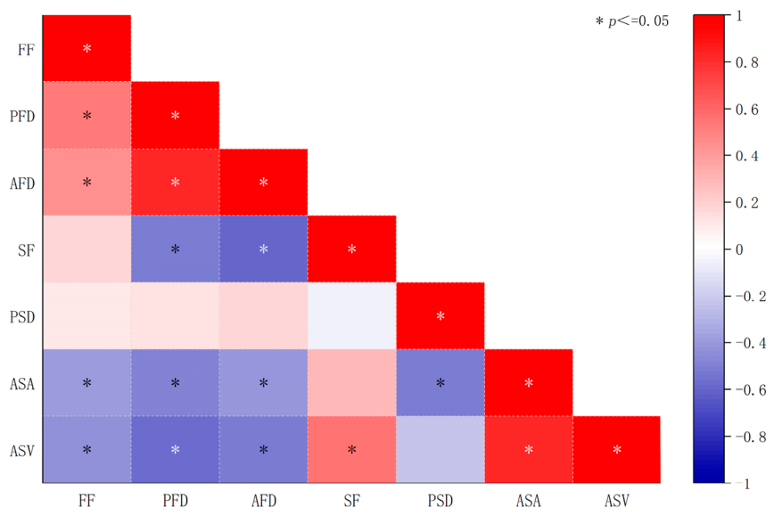
To investigate whether traditional village landscape characteristics influence participants’ visual attention behavior, correlation analyses were conducted between eight landscape perception indicators and eye-tracking metrics. The results revealed significant positive correlations between Naturalness (N), Harmony (H), Agreeableness (A), and several eye-tracking indicators. This finding suggests that landscapes characterized by greater environmental coherence and spatial comfort are more likely to attract sustained visual attention. Historicity (HI) showed a strong positive correlation with Average Fixation Duration (AFD), indicating that landscapes rich in traditional cultural attributes require longer visual information processing. In addition, Diversity (D) and Openness (O) were positively associated with Average Saccade Amplitude (ASA), suggesting that greater landscape complexity and spatial openness may expand the scope of visual exploration. In contrast, Cleanliness (C) exhibited negative correlations with several eye-tracking metrics, suggesting that differences in environmental cleanliness may influence participants’ visual attention and information-processing behavior. Overall, the results demonstrate that different landscape perception attributes are associated with distinct visual attention patterns, indicating that landscape composition and spatial characteristics can significantly influence the allocation of visual attention.
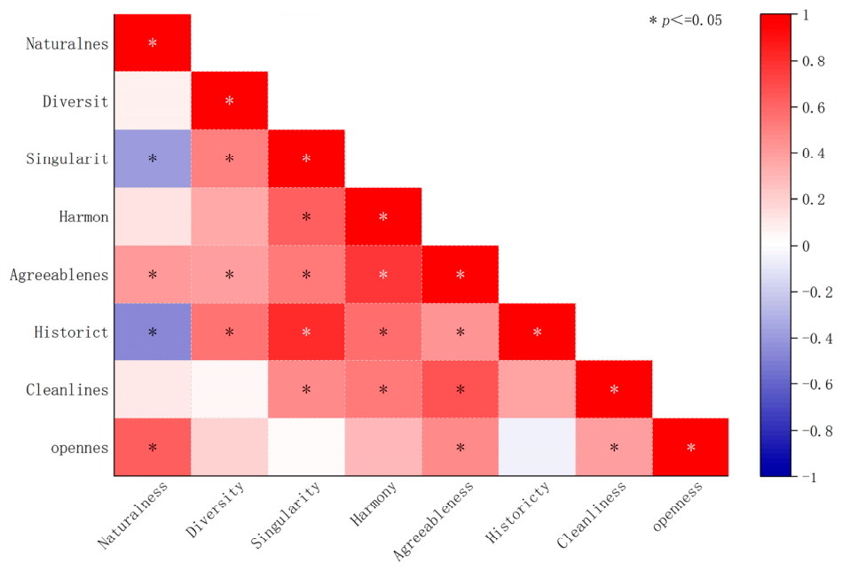
The correlation and regression analyses demonstrated that Naturalness (N), Harmony (H), Historicity (HI), and Openness (O) were significantly and positively correlated with multiple eye-tracking indicators, suggesting that the natural coherence, cultural richness, and spatial openness of traditional village landscapes exert positive effects on participants’ visual attention. Among these variables, Historicity (HI) exhibited relatively strong correlations with Average Fixation Duration (AFD) and Saccade Frequency (SF), indicating that landscapes containing abundant historical and cultural elements require more intensive visual processing and cognitive engagement (Figure 6, Table 8). By contrast, Agreeableness (A) and Cleanliness (C) showed negative correlations with several eye-tracking metrics, suggesting that differences in environmental perception may influence visual attention behavior. Furthermore, the regression analysis identified Historicity, Naturalness, and Openness as the most influential perceptual factors affecting variations in visual attention (Figure 7). Overall, the findings confirm the existence of meaningful relationships between landscape perception dimensions measured by the Semantic Differential (SD) scale and eye-tracking indicators, highlighting the important role of perceived landscape characteristics in shaping visual attention patterns.

4. Discussion

4.1. Eye-Tracking Heatmaps

The fixation locations and durations of all participants were visualized using heatmaps to illustrate the distribution of visual attention across different landscape scenes. Heatmaps represent gaze intensity through color gradients, where red regions indicate longer fixation durations and higher levels of visual attention, whereas yellow and green regions indicate progressively lower levels of visual engagement [1,26]. Overall, participants’ visual attention was primarily concentrated in the central regions of the landscape images, although distinct patterns were observed among different landscape types. In scenes N2, N8, and A3, pathways extending into the distance attracted the greatest visual attention. In A4, C5, C8, and N1, centrally located landscape elements, such as sculptures and ponds, formed the primary visual focal points. Similarly, in C1 and N4, clusters of traditional buildings received the highest levels of visual attention, indicating that visually prominent architectural features and spatial landmarks play an important role in directing gaze behavior [1,25].
The heatmap results further suggest that participants were particularly sensitive to pathway guidance, architectural structures, and building façades within traditional village public spaces. Similar findings have been reported in previous studies, which demonstrated that visual attention is strongly influenced by the spatial organization, visual prominence, and compositional characteristics of landscape elements [21,27]. Differences in the size, shape, position, and color of landscape elements contribute to distinct visual perception and preference patterns among landscape types. Architectural structures, sculptures, and other visually dominant elements are more likely to become visual focal points due to their clear forms and spatial prominence, whereas natural elements such as vegetation, mountains, and water bodies tend to generate broader and more dispersed visual exploration patterns [12,28]. These findings indicate that both the physical characteristics and spatial arrangement of landscape elements significantly influence visual attention and esthetic perception in traditional village environments.

4.2. Eye-Tracking Heatmaps of Landscape Visual Attention

The heatmap analysis revealed substantial differences in visual attention patterns among landscape types. Visual attention in cultural landscapes was highly concentrated on prominent architectural and cultural features, such as stone carvings, signboards, and traditional buildings, whereas attention in natural and agricultural landscapes was distributed more broadly across mountains, vegetation, water bodies, and transitional spaces. These findings suggest that the spatial composition, visual prominence, and arrangement of landscape elements play important roles in guiding visual attention. Elements located near the center of the visual field or possessing distinctive forms and textures were more likely to become visual focal points, while natural elements with irregular shapes and dispersed distributions generated broader visual exploration patterns. Similar observations have been reported in previous eye-tracking studies, which demonstrated that landscape composition and the spatial organization of visual elements significantly influence gaze behavior and visual perception [1,10].
The regression analysis further indicated that fixation frequency (FF) was positively associated with landscape visual quality, whereas the proportion of fixation duration (PFD) showed a negative relationship. The relatively low explanatory power of the final model (R2 = 0.121; adjusted R2 = 0.104) indicates that eye-tracking metrics explain only a limited proportion of the variation in landscape visual quality. This may reflect the limited diversity of visual stimuli, the linear specification of the model, omitted image-level visual attributes, and the multidimensional nature of landscape preference. Nevertheless, the positive association between FF and visual quality is consistent with previous eye-tracking research. Tang et al. [10] reported that landscapes receiving more frequent fixations generally attracted greater visual interest and esthetic appreciation, while Yao et al. [1] found significant associations between fixation-related indicators and perceived landscape attractiveness. These findings suggest that repeated visual attention may be associated with more positive esthetic evaluations, but the present results should not be interpreted as evidence of strong predictive capability. Future studies should integrate image-derived features, such as color, texture, edge density, spatial composition, and semantic content, and explore nonlinear or machine-learning approaches to improve the explanatory and predictive performance of the model.
From the perspective of traditional village heritage conservation, natural landscapes achieved the highest visual quality evaluations, followed by cultural landscapes. The visual attractiveness of natural landscapes may be associated with the presence of vegetation, water bodies, and open views, which provide rich visual stimuli and contribute to positive esthetic experiences. This finding is consistent with previous studies showing that natural environments enhance visual preference and restorative perception [1,17]. Meanwhile, cultural landscapes benefited from distinctive architectural features and clear visual focal points, highlighting the importance of preserving traditional architectural character and cultural identity in heritage villages. Overall, the integration of eye-tracking data and subjective evaluations provides a useful approach for understanding visual preference mechanisms and offers objective evidence to support landscape conservation, tourism planning, and environmental management in traditional villages.
The controlled laboratory setting used in this study facilitated standardized comparisons of visual attention across participants, consistent with previous image-based eye-tracking studies [29]. However, static photographs cannot fully reproduce the three-dimensional, dynamic, and multisensory experience of visiting traditional villages. In real environments, gaze behavior may also be influenced by walking, changing viewpoints, sounds, other visitors, and interactions with surrounding spaces. Field-based studies using mobile eye trackers have demonstrated the value of capturing visual attention under naturalistic conditions [30,31]. Therefore, the present results should be interpreted as controlled visual responses to representative landscape images rather than complete representations of on-site perception. Future studies should validate these findings using portable eye-tracking devices during actual visits to traditional heritage environments.

4.3. Recommendations

Based on the empirical findings from the eye-tracking and SBE–SD analyses, and supplemented by expert consultation, the following recommendations are proposed. Recommendations concerning ecological and cultural landscape elements are directly linked to the observed visual-quality and attention patterns, whereas recommendations related to infrastructure, environmental management, and community participation are primarily expert-informed complementary strategies.

4.3.1. Enhancing the Ecological Value of Traditional Village Landscape

Maintaining ecological integrity is considered one of the most effective approaches to improving landscape visual quality. Based on the experts’ opinions, several recommendations were proposed. First, the original topographic patterns of traditional villages should be respected, and excessive human intervention should be minimized. The researcher emphasized that diverse terrain conditions can promote biodiversity and enrich landscape perception [32]. Second, native plant species should be prioritized while reducing the use of exotic ornamental plants commonly found in urban landscapes. Establishing a local plant database could further strengthen the ecological and cultural identity of traditional villages. The use of indigenous vegetation helps preserve regional landscape characteristics and supports ecological sustainability [22]. Third, the natural attributes of water systems should be protected by limiting the excessive construction of hardened embankments and regularly monitoring water quality within village waterways. The researcher argued that natural water environments not only contribute to biodiversity conservation but also significantly improve visual landscape quality [25].

4.3.2. Conserving and Inheriting Cultural Heritage in Traditional Villages

Cultural heritage is regarded as an important visual and cultural resource in traditional villages, and its protection is essential for sustainable rural development. Regarding tangible cultural heritage, the experts proposed several strategies. First, newly constructed buildings should undergo strict approval procedures to ensure that their architectural forms remain consistent with the overall village character. Restoration projects should follow the principle of preserving the original appearance by using local materials and traditional construction techniques. Second, traditional craftsmen and artisans should be protected and systematically trained. Li et al. [19] noted that the skills of traditional craftsmen are associated with regional architectural culture and play a critical role in heritage conservation. Third, comprehensive restoration guidelines for traditional buildings should be established to support standardized conservation practices. Finally, detailed archives should be created for historic buildings, streets, and cultural relics, accompanied by a hierarchical protection and management system.

4.3.3. Improving Infrastructure and Environmental Management

The quality of infrastructure and environmental management directly affects both the safety of cultural heritage and the quality of life of local residents in traditional villages [33]. Accordingly, the experts proposed several recommendations. First, infrastructure systems should be strengthened, including sewage treatment facilities, waste collection and transfer stations, and fire-protection water storage systems. Such facilities are essential for improving living conditions and protecting heritage sites. Second, villagers should receive regular fire-safety education and emergency response training to improve their capacity to manage fire-related risks. Third, village sanitation management and waste-sorting systems should be implemented to improve environmental cleanliness and visual order.

4.3.4. Encouraging Community Participation

Community participation plays a fundamental role in landscape conservation and heritage protection. The experts recommended establishing incentive mechanisms to encourage residents to participate actively in activities such as maintaining village cleanliness, restoring traditional buildings, organizing folk cultural events, and preserving traditional handicrafts. As the primary stakeholders of traditional villages, local residents are essential to the long-term protection and sustainable development of rural landscapes.

5. Conclusions

(1)
Taking traditional village landscape as an example, this study applies first-hand empirical data and attempts to introduce the ET evaluation method into the assessment of landscape VQ. The findings not only provide an objective and scientific approach to evaluating the VQ of traditional village landscape but also offer a new perspective for landscape visual assessment. According to psychological principles, stimuli that satisfy individual needs and evoke positive emotional responses tend to attract greater attention and generate consistent ET patterns. This phenomenon has also been confirmed in ET studies on advertisements and web interfaces. In this study, ET data were used to explore participants’ interest characteristics and the attractiveness of landscapes, thereby evaluating LVQ. The results demonstrate that ET data have indicative value for LVQ, and that ET analysis is applicable to landscape visual assessment.
(2)
Future research could expand the demographic diversity of participants and conduct experiments in real scenic environments using actual tourists as subjects, in order to obtain more realistic evaluations of landscapes. Such efforts are expected to yield findings with greater generalizability.
(3)
This study has several limitations. First, static images cannot fully reproduce the three-dimensional, dynamic, and multisensory characteristics of real-world landscape experiences. Second, seasonal differences in vegetation conditions and illumination may have influenced participants’ visual responses, as season was not treated as a controlled experimental factor. In addition, although the same smartphone was used throughout image acquisition to minimize device-related variation, device-specific image processing may still have introduced minor differences in image appearance. Future studies should therefore validate the findings in real-world heritage environments, improve the control of seasonal conditions, and employ calibrated cameras or RAW-format images to further reduce potential visual bias.

Author Contributions

Conceptualization, J.C. and H.F.; methodology, Q.N.; software, J.C.; and Q.N.; formal analysis, J.Z. and Y.Z.; Data curation, J.Z., Q.N. and Y.Z.; writing—original draft, J.C.; writing—review and editing, H.F. and Q.N.; supervision—H.F. and A.Y. All authors have read and agreed to the published version of the manuscript.

Funding

Domestic Visiting Scholar Funding Project of West Anhui University in 2025 (No. wxxygnfx2025003); 2022 Key Laboratory Open Project of Hui-style Architecture in Anhui Province (No: HPJZ-2022-05); High-Level Talent Research Startup Fund of West Anhui University under contract No. WGKQ2022053; 2023 Annual Anhui Provincial Social Sciences Innovation and Development Research Project (Project No. 2023CX104); Anhui Provincial Key Laboratory of Hui-style Architecture Director’s Fund (Project No. 2024HPJZ-ZR02).

Institutional Review Board Statement

The study was conducted in accordance with the Declaration of Helsinki and was approved by the Scientific Research Ethics Review Committee of West Anhui University (Approval No. 202506003; date of approval: 18 June 2025). This research was approved by the Institutional Review Board (IRB) [202506003]. Any changes made to the agreement will be reviewed by the IRB. The results of this study will be disseminated by publication in a peer-reviewed journals.

Informed Consent Statement

Written informed consent was obtained from all participants involved in the study prior to their participation.

Data Availability Statement

The data supporting the findings of this study are available from the corresponding author upon reasonable request and with the permission of the corresponding author. To protect participants’ privacy and comply with the informed consent agreement, all participant data have been anonymized. Therefore, personally identifiable information is not publicly available.

Acknowledgments

The authors would like to thank those who provided helpful comments and support during the development of this study.

Conflicts of Interest

The authors declare no conflicts of interest.

Declaration of Generative AI Use

The authors report generative AI was not used in their research or preparation of this manuscript.

Abbreviations

PFDProportion of fixation duration
AFDAverage fixation duration
FFFixation Frequency
ASAAverage saccade amplitude
ASVAverage saccade velocity
SFSaccade frequency
PSDPupil size diameter
ETEye-tracking
EVQEye-tracking visual quality
LVQlandscape visual quality
VQvisual quality

References

  1. Yao, X.; Sun, Y. Using a Public Preference Questionnaire and Eye Movement Heat Maps to Identify the Visual Quality of Rural Landscapes in Southwestern Guizhou, China. Land 2024, 13, 707. [Google Scholar] [CrossRef] [Scilit]
  2. Liu, Y.; Li, Z.; Tian, Y.; Gao, B.; Wang, S.; Qi, Y.; Zou, Z.; Li, X.; Wang, R. A Study on Identifying the Spatial Characteristic Factors of Traditional Streets Based on Visitor Perception: Yuanjia Village, Shaanxi Province. Buildings 2024, 14, 1815. [Google Scholar] [CrossRef] [Scilit]
  3. Chen, G.; Yan, J.; Wang, C.; Chen, S. Expanding the Associations between Landscape Characteristics and Aesthetic Sensory Perception for Traditional Village Public Space. Forests 2024, 15, 97. [Google Scholar] [CrossRef] [Scilit]
  4. Tang, H.; Liu, X.; Li, J.; Wang, H. Study on the Conservation and Renewal of Traditional Rural Tourism Spaces: A Perspective Based on Tourists’ Revisit Intention. J. Clean. Prod. 2025, 499, 145184. [Google Scholar] [CrossRef] [Scilit]
  5. Tinker, M.A. Experimental Studies on the Legibility of Print: An Annotated Bibliography. Read. Res. Q. 1966, 1, 67–118. [Google Scholar]
  6. Xu, F. Impacts of Wind Energy Development on Landscape Planning in the Context of Carbon Neutrality. Landsc. Archit. 2022, 29, 52–58. [Google Scholar]
  7. Zakariya, K.; Ibrahim, P.H.; Wahab, N.A.A. Conceptual Framework of Rural Landscape Character Assessment to Guide Tourism Development in Rural Areas. J. Constr. Dev. Ctries. 2019, 24, 85–99. [Google Scholar] [CrossRef] [Scilit]
  8. Chen, J.; Yan, A.; Sun, H. Study on Landscape Characteristics and Formation Mechanism of Chinese Traditional Settlements Based on Niche Theory; Springer: Berlin/Heidelberg, Germany, 2023; pp. 551–559. [Google Scholar]
  9. Meng, S.; Liu, C.; Zeng, Y.; Xu, R.; Zhang, C.; Chen, Y.; Wang, K.; Zhang, Y. Quality Evaluation of Public Spaces in Traditional Villages: A Study Using Deep Learning and Panoramic Images. Land 2024, 13, 1584. [Google Scholar] [CrossRef] [Scilit]
  10. Tang, Z.; Xu, X.; Wang, F.; Zhang, L.; Zhu, M. Effect of Interface Layout Design of a Public Library Website on Information-Seeking Experience for Elderly People. Libr. Hi Tech 2025, 43, 746–762. [Google Scholar] [CrossRef] [Scilit]
  11. Jin, L.; Wang, Z.; Chen, X. Spatial Distribution Characteristics and Influencing Factors of Traditional Villages on the Tibetan Plateau in China. Int. J. Environ. Res. Public Health 2022, 19, 13170. [Google Scholar] [CrossRef] [Scilit] [PubMed]
  12. Luo, H.; Deng, L.; Jiang, S.; Song, C.; Fu, E.; Ma, J.; Sun, L.; Huang, Z.; Jiang, M.; Zhu, C. Assessing the Influence of Individual Factors on Visual and Auditory Preference for Rural Landscape: The Case of Chengdu, China. J. Environ. Plan. Manag. 2022, 65, 727–744. [Google Scholar] [CrossRef] [Scilit]
  13. Xing, Y.; Leng, J. Evaluation of Public Space in Traditional Villages Based on Eye Tracking Technology. J. Asian Archit. Build. Eng. 2024, 23, 125–139. [Google Scholar] [CrossRef] [Scilit]
  14. Zhang, S.; Cheng, Z.; Liang, W.; Ding, L. For the Better Protection of Wetland Resources: Net Value of Ecosystem Services after Protective Development of Xixi Wetland in Hangzhou, China. Sustainability 2023, 15, 5913. [Google Scholar] [CrossRef] [Scilit]
  15. Su, T.; Wang, K.; Li, S.; Wang, X.; Li, H.; Ding, H.; Chen, Y.; Liu, C.; Liu, M.; Zhang, Y. Analysis and Optimization of Landscape Preference Characteristics of Rural Public Space Based on Eye-Tracking Technology: The Case of Huangshandian Village, China. Sustainability 2022, 15, 212. [Google Scholar] [CrossRef] [Scilit]
  16. Tang, C.; He, S.; Liu, W.; Zhang, W.; Zhang, M. Environmental Study on Differentiation and Influencing Factors of Traditional Village Lands Based on GIS. Ekoloji Derg. 2019, 4685. [Google Scholar]
  17. Goto, S.; Takase, H.; Yamaguchi, K.; Kato, T.; Sun, M.; Koga, A.; Liang, T.; Poy, I.A.; Herrup, K. Eye Movement Patterns Drive Stress Reduction during Japanese Garden Viewing. Front. Neurosci. 2025, 19, 1581080. [Google Scholar] [CrossRef] [Scilit]
  18. Zhang, Y.; Hong, Y.; Lin, L. Study on Influencing Factors of Public Space Vitality of Mountainous Traditional Villages in Southern Zhejiang. Dev. Small Cities Towns 2022, 40, 84–92. [Google Scholar]
  19. Li, Y.; Yao, Z.; Guo, Z. Willingness to Pay and Preferences for Rural Tourism Attributes among Urban Residents: A Discrete Choice Experiment in China. Econ. Anal. Policy 2023, 77, 460–471. [Google Scholar] [CrossRef] [Scilit]
  20. Guo, S.; Zhao, N.; Zhang, J.; Xue, T.; Liu, P.; Xu, S.; Xu, D. Landscape Visual Quality Assessment Based on Eye Movement:College Student Eye-Tracking Experiments on Tourism Landscape Pictures. Resour. Sci. 2017, 39, 1137–1147. [Google Scholar] [CrossRef]
  21. Wang, Z.; Zhou, Q.; Man, T.; He, L.; He, Y.; Qian, Y. Delineating Landscape Features Perception in Tourism-Based Traditional Villages: A Case Study of Xijiang Thousand Households Miao Village, Guizhou. Sustainability 2024, 16, 5287. [Google Scholar] [CrossRef] [Scilit]
  22. Li, X.; Wang, P.; Li, L.; Liu, J. The Influence of Architectural Heritage and Tourists’ Positive Emotions on Behavioral Intentions Using Eye-Tracking Study. Sci. Rep. 2025, 15, 1447. [Google Scholar] [CrossRef] [Scilit] [PubMed]
  23. Zhuang, W. SD Method Related to Evaluation of Architectural Space Objectives. J.-Tsinghua Univ. 1996, 36, 42–47. [Google Scholar]
  24. Mundher, R.; Al-Sharaa, A.; Al-Helli, M.; Gao, H.; Abu Bakar, S. Visual Quality Assessment of Historical Street Scenes: A Case Study of the First “Real” Street Established in Baghdad. Heritage 2022, 5, 3680–3704. [Google Scholar] [CrossRef] [Scilit]
  25. Gao, H.; Abu Bakar, S.; Maulan, S.; Mohd Yusof, M.J.; Mundher, R.; Zakariya, K. Identifying Visual Quality of Rural Road Landscape Character by Using Public Preference and Heatmap Analysis in Sabak Bernam, Malaysia. Land 2023, 12, 1440. [Google Scholar] [CrossRef] [Scilit]
  26. Ren, H.; Yang, F.; Zhang, J.; Wang, Q. Evaluation of Cognition of Rural Public Space Based on Eye Tracking Analysis. Buildings 2024, 14, 1525. [Google Scholar] [CrossRef] [Scilit]
  27. Luo, J.; Zhao, T.; Cao, L.; Biljecki, F. Semantic Riverscapes: Perception and Evaluation of Linear Landscapes from Oblique Imagery Using Computer Vision. Landsc. Urban Plan. 2022, 228, 104569. [Google Scholar] [CrossRef] [Scilit]
  28. Ode, Å.; Tveit, M.S.; Fry, G. Capturing Landscape Visual Character Using Indicators: Touching Base with Landscape Aesthetic Theory. Landsc. Res. 2008, 33, 89–117. [Google Scholar] [CrossRef] [Scilit]
  29. Dupont, L.; Antrop, M.; Van Eetvelde, V. Eye-Tracking Analysis in Landscape Perception Research: Influence of Photograph Properties and Landscape Characteristics. Landsc. Res. 2014, 39, 417–432. [Google Scholar] [CrossRef] [Scilit]
  30. Cottet, M.; Vaudor, L.; Tronchère, H.; Roux-Michollet, D.; Augendre, M.; Brault, V. Using Gaze Behavior to Gain Insights into the Impacts of Naturalness on City Dwellers’ Perceptions and Valuation of a Landscape. J. Environ. Psychol. 2018, 60, 9–20. [Google Scholar] [CrossRef] [Scilit]
  31. De la Fuente Suárez, L.A. Subjective Experience and Visual Attention to a Historic Building: A Real-World Eye-Tracking Study. Front. Archit. Res. 2020, 9, 774–804. [Google Scholar] [CrossRef] [Scilit]
  32. Silitonga, R.M.; Sukwadi, R.; Inderawati, M.M.W.; Yanto; Jou, Y.-T. Designing Eye-Tracking Experiment to Enhance Reading Comprehension in Online Learning Environment. Eng. Proc. 2025, 103, 11. [Google Scholar] [CrossRef] [Scilit]
  33. Wu, C.; Chen, M.; Zhou, L.; Liang, X.; Wang, W. Identifying the Spatiotemporal Patterns of Traditional Villages in China: A Multiscale Perspective. Land 2020, 9, 449. [Google Scholar] [CrossRef] [Scilit]
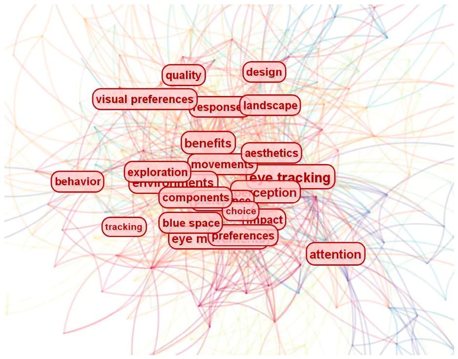
Figure 1. Keyword co-occurrence network in eye-tracking and landscape perception research.
Buildings 16 03747 g001
Figure 2. Timeline visualization of keyword clusters in eye-tracking and landscape perception research.
Buildings 16 03747 g002
Figure 3. Location map of Hongcun and Xidi villages.
Buildings 16 03747 g003
Figure 4. Hongcun village.
Buildings 16 03747 g004
Figure 5. Xidi village.
Buildings 16 03747 g005
Figure 6. Triangular correlation heatmap among eye-tracking metrics.
Buildings 16 03747 g006
Figure 7. Correlation heatmap of SD indicators.
Buildings 16 03747 g007
Table 1. Classification of traditional village landscape types and their main landscape element.
Landscape TypesPicture
Code
Specific Landscape CategoryMain Landscape Elements and Characteristics
Farmland
landscape
F1Paddy field and distant mountain landscapeFarmland, distant mountains, villagers, rural open space, vegetation
F2Agricultural planting and greenhouse landscapeGreenhouses, crops, farmland, mountains, agricultural facilities
F3Terraced farmland and rural cultivation landscapeTerraced fields, vegetation, forests, rural paths, natural boundaries
F4Golden rice field landscapePaddy fields, rural roads, distant mountains, vegetation, agricultural scenery
Artificial
landscape
A1Parking Facilities and Road LandscapeParking areas, vehicles, roads, artificial facilities, pedestrians
A2Artificial Planting Courtyard LandscapeCourtyard buildings, vegetation, artificial pavement, outdoor furniture
A3Man-Made Walkway LandscapeWalkways, trees, recreational facilities, pedestrians
A4Artificial WaterscapeLandscape archways, artificial structures, lighting facilities, tourists
A5Artificial StructuresPublic plazas, pavilion corridors, activity spaces, visitors
A6Man-Made Residential Courtyard LandscapeCommercial facilities, streets, vehicles, pedestrians, signage
A7Commercial street landscapeShops, commercial spaces, tourists, street facilities, advertisements
A8Courtyard leisure landscapeLeisure facilities, courtyard decorations, vegetation, seating areas
Cultural landscapeC1Waterside settlement landscapeWater bodies, Hui-style architecture, settlement reflections, cultural scenery
C2Ground, couplets, furnitureTraditional architecture, memorial archways, carved decorations, lanterns
C3Ground, couplets, furnitureInterior furnishings, traditional furniture, cultural decorations
C4Traditional architecture, ground, Artificial structures, trees, skyWooden structures, architectural doors and windows, lanterns, carvings
C5Traditional architecture, people, vehiclesWaterfront streets, traditional buildings, commercial activities, tourists
C6Traditional alley cultural landscapeAlley spaces, cultural symbols, shops, pedestrians
C7Traditional architectural entrance landscapeBuilding entrances, lanterns, cultural decorations, tourists
C8Traditional courtyard cultural landscapeCourtyard space, leisure environment, traditional cultural atmosphere
Natural landscapeN1Waterwheel and lotus pond landscapeWater bodies, lotus pond, traditional settlements, waterwheel, vegetation
N2River and embankment landscapeRivers, embankments, distant mountains, vegetation, ecological environment
N3Mountain forest landscapeForests, mountains, sky, natural vegetation, wildlife habitat
N4Settlement and pastoral panoramic landscapeTraditional settlements, farmland, distant mountains, open landscape views
N5River waterfall landscapeRivers, waterfalls, dams, mountains, natural ecological features
N6Mountain grassland landscapeMountains, grassland, vegetation, open rural natural space
N7Forest and grassland landscapeTrees, grassland, ecological vegetation, natural environment
N8Distant village landscapeMountains, villages, sky, vegetation, broad visual field
Table 2. The overall data of the demographic survey.
VariableCategoryFrequencyValid Percent
GenderMale20755.35%
Female16744.65%
AgeUnder 1841.07%
18 to 2516644.39%
26 to 359124.33%
36 to 456216.58%
46 to 554411.76%
Above 5571.87%
Educational levelHigh school and below205.35%
Bachelor’s degree22860.96%
Master’s degree7319.52%
Ph.D.5314.17%
Have you ever been to Hongcun/Xidi Village beforeYes20254.01%
No17245.99%
Frequency of visits to traditional villagesLess than once a year21457.22%
Twice a year8322.19%
Three to five times a year4211.23%
More than 5 times a year359.36%
Current occupationStudent17145.72%
Self-employed person123.21%
Private sector employee266.95%
Government employee277.22%
Teacher/Professor6116.31%
Other occupation7720.59%
Table 3. Definitions and significance of eye-tracking indicators.
IndicatorSignificance
Average Fixation Duration (AFD)Refers to the average duration of fixations during visual observation. Longer fixation durations generally indicate deeper cognitive processing and greater visual attention
Proportion of Fixation Duration (PFD)Represents the proportion of total fixation time allocated to a specific landscape element or area of interest (AOI).
Average Saccade Amplitude (ASA)Refers to the average angular distance between two consecutive fixation points during visual observation. Larger values indicate a broader visual exploration range and greater spatial scanning behavior.
Average Saccade Velocity (ASV)Refers to the average speed of eye movement between fixation points and reflects the efficiency and dynamics of visual scanning.
Saccade Frequency (SF)Refers to the number of saccadic eye movements occurring within a given observation period and reflects visual search activity and attentional scanning behavior.
Fixation Frequency (FF)Represents the number of fixations occurring within a certain period or area. Higher fixation frequency generally indicates stronger visual attraction and attention.
Pupil Size Diameter (PSD)Refers to the average pupil diameter recorded during image viewing and is commonly used to reflect cognitive load, emotional arousal, and attentional engagement.
Table 4. Factor analysis results and normalized weights of the SD indicators.
SD IndicatorFactor 1 LoadingFactor 2 LoadingCommunalityFinal Normalized Weight
Naturalness (N)0.840.220.7540.19
Diversity (D)0.730.340.6490.14
Harmony (H)0.810.280.7350.16
Singularity (S)0.310.490.3360.04
Agreeableness (A)0.760.260.6450.13
Historicity (HI)0.240.860.7970.14
Cleanliness (C)0.480.610.6030.10
Openness (O)0.690.320.5790.10
Note: KMO = 0.846. Bartlett’s test of sphericity: χ2 = 1128.4, df = 28, p < 0.001. Principal component analysis was used for factor extraction, and two components with eigenvalues greater than 1 were retained. Varimax rotation with Kaiser normalization was applied. Factor 1 and Factor 2 explained 41.66% and 22.05% of the variance, respectively, yielding a cumulative variance explained of 63.71%.
Table 5. Multiple comparisons of eye movement indicators for different landscape types.
FFPFDAFD (ms)SF (count/s)PSDASA/°ASV (°/S)
Overall Difference
(p value)
<0.001 *0.9810.042 *0.004 *0.480.540.765
Cultural Landscape (C)2.67 d0.820457.502.8 d0.072.9089.50
Natural Landscape (N)2.69 d0.862460.762.7 d0.0702.6882.47
Artificial Landscape (A)2.58 d0.851500.502.2 d0.062.9086.34
Farmland
Landscape (F)
2.39 abc0.870518.362.1 abc0.073.6091.42
Note: * Indicates a significant difference at the 0.05 level; 2.39 abc in the agricultural landscape represents the average value of the annotation frequency of the agricultural landscape, and abc indicates a significant difference between the agricultural landscape and cultural landscape, natural landscape, and artificial landscape. The interpretation method for other values is the same as this. Although the overall difference in AFD was statistically significant (p = 0.042), none of the post hoc pairwise comparisons remained significant after adjustment for multiple comparisons.
Table 6. Correlation analysis between eye movement indices and subjective evaluation value of landscape visual quality.
FFPFDAFDSFASAASVPSD
VQPearson Correlation0.107 *−0.128 **−0.110 *0.0800.0300.0700.092
Sig.0.0210.0060.0170.0840.5170.1300.047
N117117117117117117117
Table 7. Stepwise multiple regression coefficients.
ModelVariableUnstandardized
Coefficients
βtpR2Adjusted R2Durbin–Watson
BSE
Model 1(Constant)6.8990.347-19.889<0.0010.0160.014-
PFD−1.1200.401−0.128−2.7860.006
Model 2(Constant)6.4550.384-16.851<0.0010.0310.0271.76
PFD−1.2480.402−0.142−3.1010.002
FF0.2260.0850.1232.6580.008
Note: B = unstandardized regression coefficient; SE = standard error; β = standardized regression coefficient.
Table 8. Pearson correlation analysis between landscape SD indicators and eye-tracking metrics.
IndicatorFFPFDAFDSFPSDASAASV
Naturalness (N)0.284 *−0.215 *−0.173 *0.1020.231 *0.0840.067
Diversity (D)0.317 **−0.194−0.2010.1180.2640.0910.072
Harmony (H)0.352 **0.1430.186 *0.205 *0.1740.0970.083
Singularity (S)0.221 *0.0840.1050.1640.193 *0.0760.054
Agreeableness (A)−0.108−0.237 *−0.281 **−0.096−0.144−0.082−0.061
Historicity (HI)0.336 **0.176 *0.208 *0.213 *0.241 *0.1150.092
Cleanliness (C)−0.096−0.254 *−0.302 **−0.118−0.165−0.074−0.058
Openness (O)0.291 *0.1320.174 *0.224 *0.201 *0.0890.071
Note: * p < 0.05; ** p < 0.01.
Disclaimer/Publisher’s Note: The statements, opinions and data contained in all publications are solely those of the individual author(s) and contributor(s) and not of MDPI and/or the editor(s). MDPI and/or the editor(s) disclaim responsibility for any injury to people or property resulting from any ideas, methods, instructions or products referred to in the content.