Article

Sonic and Haptic Encounters with Industrial Heritage in Transition: An Exploratory Study of Bomonti, Istanbul

by
Hasan Basri Kartal
1,* and
Asiye Nisa Kartal
2
1
Department of Architecture, Mimar Sinan Fine Arts University, Istanbul 34427, Türkiye
2
Department of Architecture, Istanbul Technical University, Istanbul 34437, Türkiye
*
Author to whom correspondence should be addressed.
Buildings 2026, 16(18), 3691; https://doi.org/10.3390/buildings16183691
Submission received: 22 August 2026 / Revised: 11 September 2026 / Accepted: 14 September 2026 / Published: 16 September 2026

Abstract

Industrial heritage is often evaluated through preserved fabric, new functions, and visual character, while the situated sensory consequences of reuse and adjoining redevelopment receive less attention. This exploratory pilot study examines sonic and haptic encounters along a predetermined route connecting industrial heritage, adaptive reuse, older streets, and high-rise redevelopment in Bomonti, Istanbul. The design-trained author-researchers familiar with the district conducted a paired sensewalk on a summer weekday afternoon, producing a photographic corpus, field notes with simple sketches, and continuous digital route recordings that also captured their in-walk conversation. The materials were jointly interpreted through reflexive cross-modal analysis. Sonic territories and haptic urbanism were used as complementary analytical dimensions, while sensory unevenness described cross-cutting differences among route settings. Traffic, commercial activity, cultural programming, courtyards, material transitions, slopes, thresholds, and controlled access shaped this particular encounter. These sensory cues became relevant to heritage meaning only when interpreted through spatial relations, historical knowledge, memory, present use, and access; they were not treated as heritage values in themselves. Experiential heritage value is therefore advanced as a situated interpretive lens rather than a general measurement. The study neither provides a causal account of urban transformation mechanisms nor establishes a stable sensory inventory of Bomonti; it offers a bounded approach for investigating how transformed heritage settings are perceived and interpreted.

1. Introduction

Heritage-led urban transformation is commonly made legible through conserved structures, restored facades, new functions, and changes in land use and skyline. Such readings are essential but incomplete because industrial heritage is also encountered as an environment of sound, material contact, movement, access, and social occupation. Adaptive reuse changes inherited fabric, functions, and heritage interpretation [1,2,3], but it also changes how a former industrial building is approached, heard, touched, and incorporated into everyday urban life. Experiential heritage value is used here to describe this situated significance: the value produced when inherited materials, spatial configurations, memories, and contemporary uses are perceived through the moving body. A sensory approach therefore asks how conservation and redevelopment become audible and tangible at street level [4,5,6,7].
International heritage practice and values-based scholarship likewise treat significance as plural and dynamic: tangible fabric is considered together with intangible associations, social and use values, everyday urban life, and the meanings attributed by people [8,9,10,11,12,13]. This expanded understanding provides the basis for examining sensory experience as one situated route into heritage interpretation, without equating sensory stimulus with heritage value.
Sensewalking [14] is a walking-based qualitative method in which participants move through a defined environment while deliberately attending to sensory conditions and documenting perceptions as they arise. Its methodological lineage includes smellwalks [15,16], soundwalks [17], and combined sensory walks that examine interactions among sound, light, smell, materiality, movement, and bodily orientation [15,16,17]. When applied to built heritage, sensewalking can supplement visual and fabric-based assessment by tracing how material continuity, acoustic character, thresholds, permeability, thermal conditions, and accessibility affect the lived experience of inherited places [4,18]. A paired format additionally makes noticing and interpretation dialogic, allowing sensory impressions to be compared and contextualised while the environment is being traversed [4,5]. The practice has roots in Westerkamp’s formulation of soundwalking as an intentionally listening-centred excursion [19] and in Southworth’s urban-design account of listening as a way to read the city [20]. More broadly, walking research across disciplines treats movement as an embodied, place-sensitive mode of inquiry and knowledge production rather than simply a means of moving between observation points [21].
Bomonti offers a particularly productive setting for examining experiential heritage value under conditions of rapid change. Emerging as an early industrial area around the brewery established by the Bomonti brothers, the district accumulated factories, religious and minority heritage, housing, and commercial life before deindustrialisation and accelerated redevelopment [2,22]. Today, industrial structures and older streets coexist with Bomontiada’s cultural adaptive reuse, hotels, gated developments, and high-rise residences. Studies of Bomonti document the reconfiguration of urban memory and cultural uses through transformation [23,24]. Against this context, the present study examines how inherited buildings are encountered through sonic relations, thresholds, publicness, and pedestrian conditions.
Existing research has interpreted Bomonti through industrial heritage, adaptive reuse, collective memory, responsive environments, green architecture, gentrification, and creative and cultural production [23,24,25,26]. Research on sensory methods, meanwhile, clarifies how places are encountered through sound, touch, movement, and memory [4,5,17,18]. Bringing these studies together raises a route-scale question. The issue is not simply whether transformed heritage can be sensed, but how sonic and haptic cues acquire heritage relevance through spatial cognition, documented history, present use, memory, and access. The study’s research entry point is therefore the route-scale relationship among sensory encounter, industrial heritage value, and the surrounding urban layers through which reuse is approached. It brings fabric-centred accounts of transformation into dialogue with sensory approaches to heritage valuation; it does not claim to model the mechanisms or population-level impacts of redevelopment.
In this article, heritage-led urban transformation denotes the documented coexistence of conservation, adaptive reuse, and redevelopment in Bomonti; it provides the context of inquiry rather than the causal process being modelled. The study examines how selected transformed heritage settings are perceived and interpreted at street level. It does not seek to explain the institutional, financial, planning, displacement, or population-level social mechanisms through which the district’s transformation occurred.
This exploratory pilot study addresses two questions: (1) What sonic and haptic qualities were encountered during one bounded paired sensewalk across industrial heritage, adaptive reuse, older urban fabric, and high-rise redevelopment in Bomonti? (2) How can these situated encounters inform an interpretation of experiential heritage value in this specific urban context? The two design-trained authors followed a predetermined route and jointly analysed field notes and sketches, two continuous MP3 route recordings containing environmental sound and in-walk conversation, and 55 unique photographs. The purpose is to examine how transformed heritage spaces were perceived and interpreted under defined field conditions, not to provide a representative sensory inventory or a causal explanation of Bomonti’s urban transformation mechanisms.

2. Literature Review

2.1. Bomonti: Industrial Heritage, Urban Transformation, and Layered Urban Life

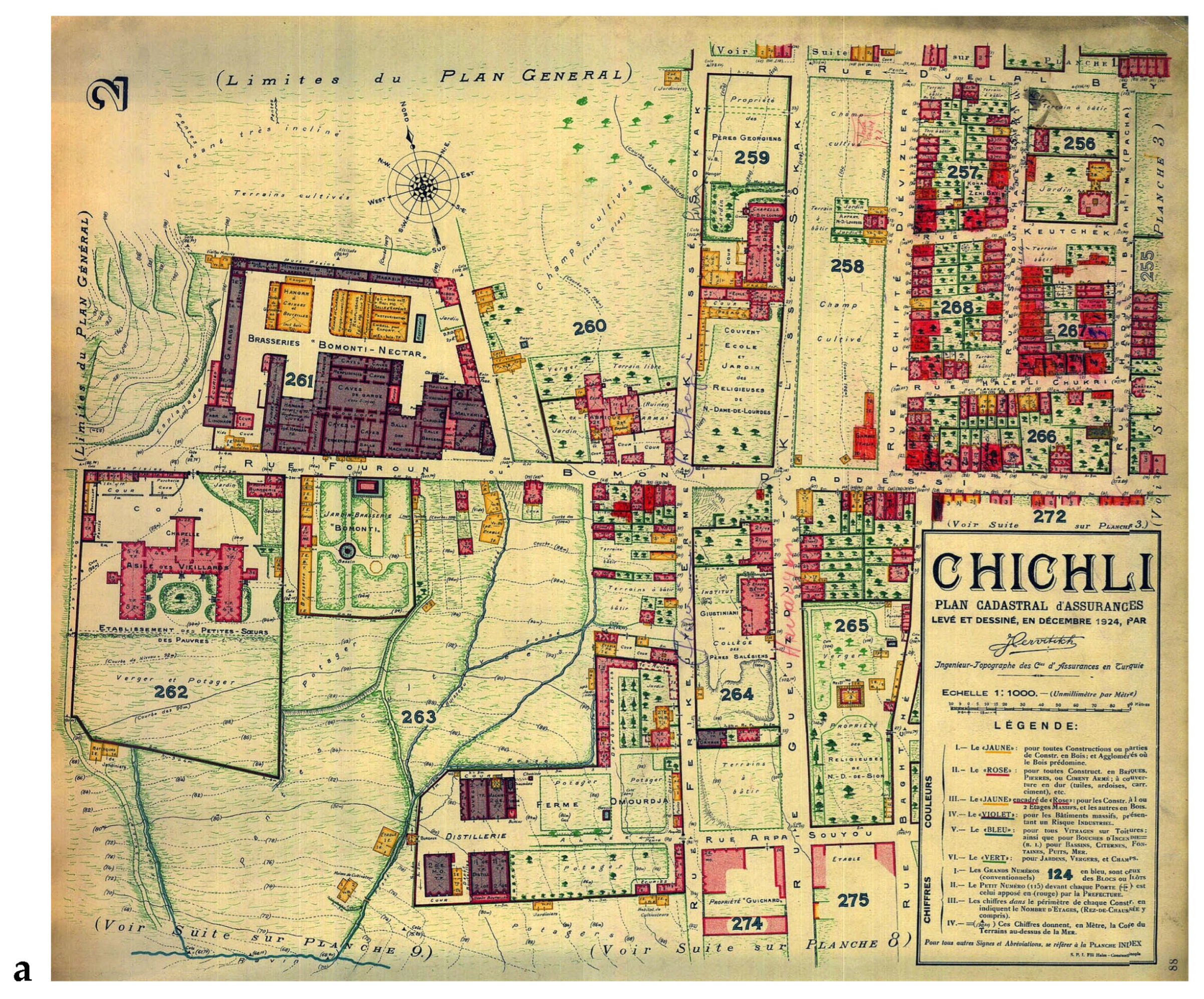
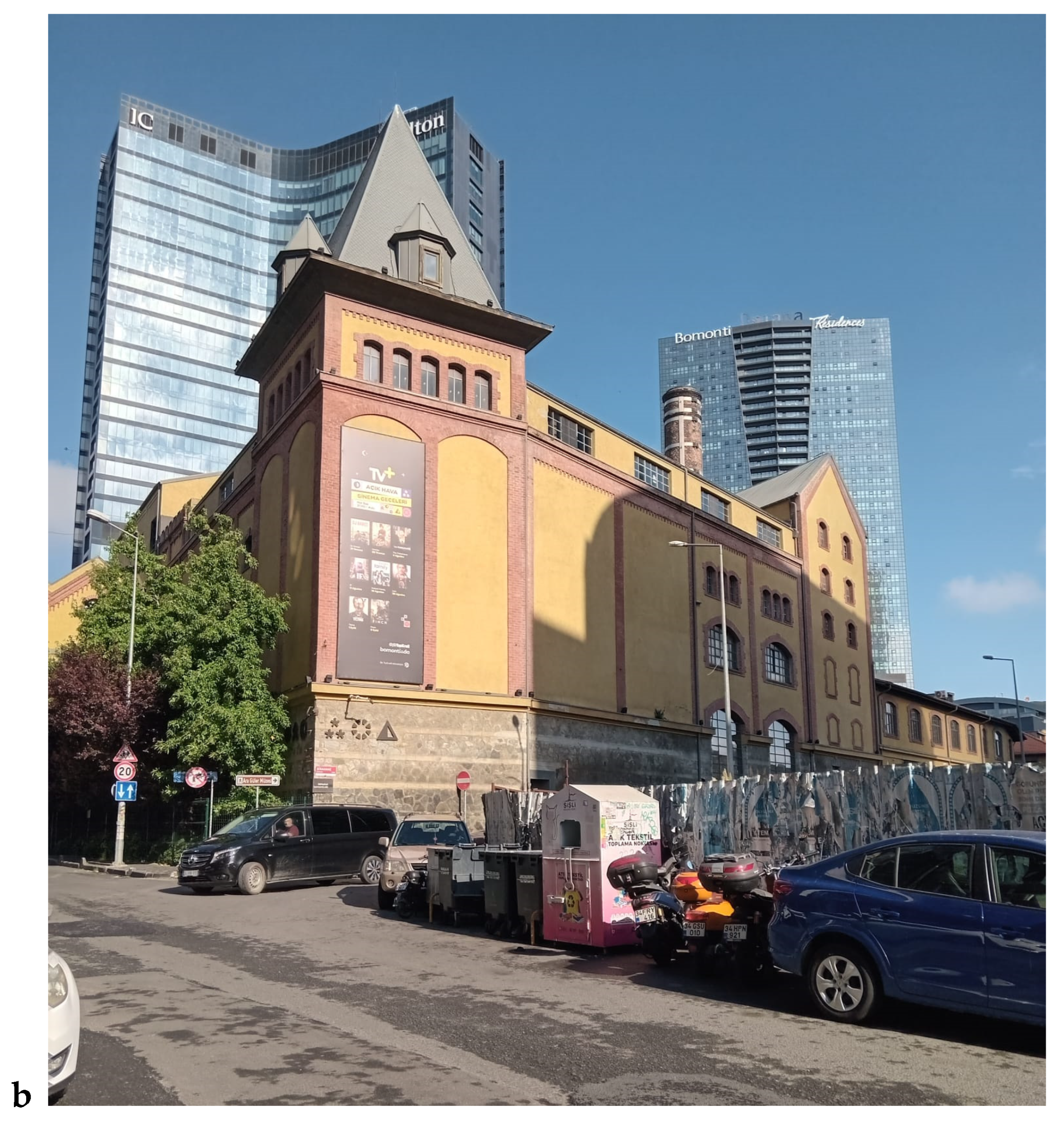
Bomonti’s contemporary complexity is rooted in its formation as an industrial and socially heterogeneous district. Historical studies trace how industrialisation shaped its architectural fabric, settlement patterns, and relation to Istanbul, while the brewery became a technological landmark and generator of neighbourhood identity [2,22]. Mapping-oriented research draws attention to spatial variation and minority communities across Şişli–Bomonti–Feriköy, while morphological work situates the district within longer processes of inner-city change [27,28]. Industrial heritage in Bomonti is therefore both material evidence of production and a framework through which cultural memory, urban identity, and contemporary development are negotiated. Jacques Pervititch’s 1924 fire-insurance plan records the Bomonti-Nectar Brewery as a large, internally differentiated industrial compound among cultivated land, gardens, religious institutions, and emerging residential blocks [29], while Figure 1b shows Bomontiada’s retained fabric framed by adjacent high-rise development. Together, Figure 1a,b makes the factory’s early scale and urban setting legible.
Doldur’s account situates Bomonti’s industrial development and subsequent change within the district’s inner-city location and its relations to markets, labour, and transport [30]. Er’s archive- and survey-based inventory documents a wider institutional and residential landscape, including Catholic schools and churches, water-supply structures, masonry apartments, garden houses, and later informal settlements alongside factories [22]. Read together, these studies support an interpretation of the neighbourhood through the interdependence of production, worship, education, infrastructure, residence, and leisure, rather than industry alone. This longer history is important for sensory interpretation: the abrupt changes encountered within short walking intervals are not only effects of recent redevelopment but also inherit an earlier pattern of functional and social interweaving.
The conversion of industrial premises into cultural and commercial destinations has made adaptive reuse central to Bomonti’s identity and to its heritage-led urban transformation. Toprak and Hacihasanoglu [24] interpret the brewery’s transformation into Bomontiada through cultural processes and heterotopic space, whereas Yenel [3] treats industrial buildings as carriers of technological, social, architectural, and material value that require more than functional change. Bilge warns that selective reuse can threaten the integrity of industrial heritage [1]. Öztürk’s comparison of cultural reuse in Turkey and Europe further draws attention to the distinction between building-focused interventions and the treatment of industrial complexes as a whole [31]. Experiential heritage value extends this debate by asking whether material continuity, spatial sequence, acoustic character, access, and public use remain perceptible after conversion. Moshaver [32] similarly frames adaptive reuse as a tectonic dialogue in which new intervention both complements and challenges inherited industrial fabric, preserving the spirit of place while making temporal layers legible. Broader scholarship conceptualises adaptive reuse as both an architectural discipline and a staged process involving heritage-value assessment, design strategy, implementation, maintenance, and subsequent evaluation [33,34]. Stakeholder research also positions reuse within sustainability and urban regeneration while identifying tensions among conservation priorities, viability, and development [35]. A recent account similarly emphasises balancing historic integrity, contemporary functionality, and stakeholder needs [36].
At the scale of the brewery, Er’s architectural reconstruction further shows that the heritage object is not a single, temporally uniform shell. The complex accumulated residential, administrative, malting, boiling, fermentation, storage, laboratory, and service blocks from the early twentieth century through later production phases [22], complementing earlier architectural documentation [2]. Masonry, solid brick, reinforced concrete, vaults, altered openings, and interconnecting additions recorded changes in technology and operation. Adaptive reuse must therefore be assessed against the legibility of this accretive production system, not only the survival of its most recognisable facades. The value of a courtyard, threshold, wall, or volume lies partly in its former relation to other blocks and processes. Reuse can make these layers newly accessible, but selective retention can also separate atmospheric industrial character from the functional relationships that produced it [37]. Langenberg’s concept of “transformation value” offers a complementary position by treating repair, adaptability, and continued renewal as heritage-relevant capacities rather than as changes necessarily opposed to conservation [38].
Transformation has produced sharp differences between ‘old’ and ‘new’ Bomonti. The responsive-environments approach has been applied to residential areas in studies comparing ‘old’ and ‘new’ Bomonti [25]. Gürleyen and Ocakçı [23] describe a metamorphosis of memory through homogenisation, hybridisation, and the replacement of locally embedded environments by spaces of circulation and consumption. Longitudinal research similarly associates high-rise development with uneven change and the side-by-side presence of socially and spatially disconnected worlds [39,40]. Read together, these studies motivate the present study’s focus on relations between conserved buildings and surrounding streets, including access, publicness, and sensory experience. Research on high-rise buildings in Türkiye also foregrounds function and internal space efficiency, but these building-centred metrics do not by themselves explain how towers reshape street-level sensory relations [41].
Bomonti has also been interpreted through metamodern theory as a setting in which temporal and aesthetic registers coexist [42]. Reference [43] is primary promotional material issued by a commercial hospitality actor. It packages Bomonti as a visitor route linking the historic factory, cultural consumption, gastronomy, local commerce, and luxury towers. It is used here only to examine how the district is represented in commercial and tourism discourse—not as scholarly evidence about Bomonti’s transformation. The promotional narrative illustrates how contrast itself becomes marketable, foregrounding heritage as atmosphere while leaving accessibility, permeability, and everyday publicness unresolved.
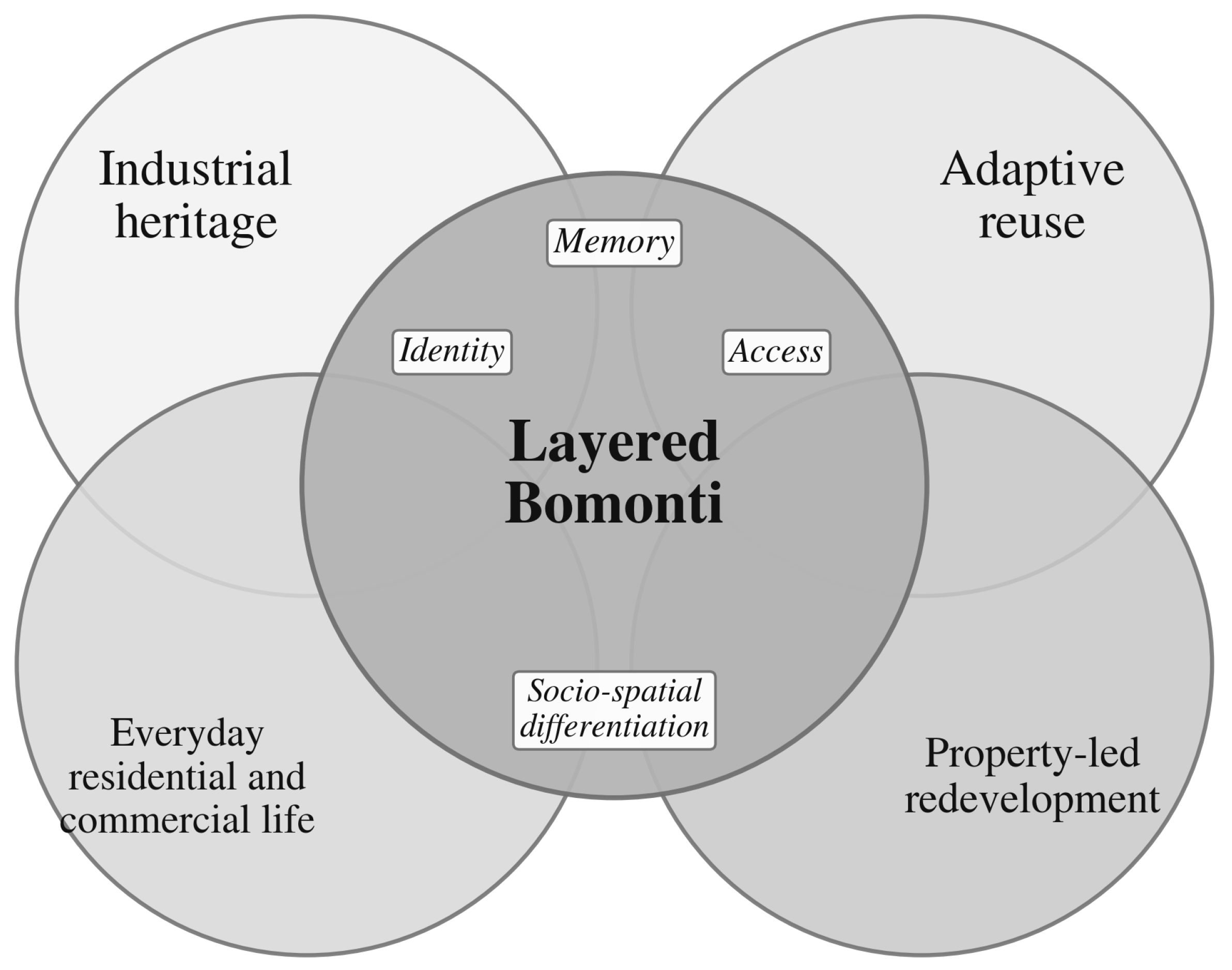
Figure 2 synthesises this literature by positioning Bomonti’s contemporary condition at the intersection of industrial heritage, adaptive reuse, everyday neighbourhood life, and property-led redevelopment. Their overlaps show that memory, identity, access, and socio-spatial differentiation are produced through coexistence rather than the complete replacement of one layer by another. Architectural documentation and studies of urban memory and cultural change provide the contextual basis for these relationships [2,23,24]. In this study, experiential heritage value describes how retained fabric is interpreted through contemporary use, movement, and sensory encounter.
Industrial heritage scholarship makes the connection with sensory inquiry particularly important. Berger and High caution against reducing (de-)industrial heritage to preserved remains, directing attention to the politics of heritage making and the social inheritances of industrial loss [44]. Spatial narrative research likewise relates protection to the organisation of material traces, historical information, movement, and contemporary interpretation [45]. Cheng and Bowring show more specifically how rust, dust, smoke, and smell can compose industrial memoryscapes (a socio-spatial construct where physical landscapes, architecture, and environments intersect with individual or collective memory) beyond surviving architectural form [46]. Sensory evidence is therefore heritage-relevant not because every sound, texture, smell, or atmosphere is intrinsically valuable, but because it may disclose—or obscure—relationships among production history, retained fabric, spatial sequence, memory, adaptive reuse, and present occupation. This provides the conceptual bridge between the industrial heritage discussion above and the sensory methods examined below.

2.2. Sensory Methods and the Experiential Evaluation of Built Heritage

Built heritage assessment commonly privileges architectural form, material authenticity, physical condition, and functional change. Sensewalking does not replace these criteria; it adds an experiential register by examining how inherited environments are perceived through movement, attention, memory, and bodily orientation. Smellwalking research demonstrates how mobile methods make backgrounded stimuli, atmosphere, and situated interpretation available for qualitative analysis, while sensory mapping translates ephemeral encounters into spatially communicable records [15,16]. Kępczyńska-Walczak positions ambiance and perception within a process of heritage decoding [47], while Parker et al. review sensory and multisensory perception as a field of cultural heritage inquiry [48]. Bendix cautions that bringing lived sensory experience into heritage making also entails selection and valorisation [49], and Jordan et al. foreground methodological transparency across embodied, collective, recorded, and reconstructed engagements with the past [50]. Acoustic heritage research and soundscape research at industrial sites further connect embodied listening with tangible and intangible significance and place-making [6,7]. Adjacent work on curated interactive journeys, the experience economy, and restorative perception shows how sensory engagement can be designed or evaluated in renovated or cultural settings [51,52,53]. The present study differs by examining street-level sonic and haptic encounters along a route linking a reused industrial complex with everyday streets and redevelopment interfaces; these encounters were not staged for the research. The study neither reconstructs a former factory sensorium nor evaluates a designed visitor journey or health outcome. Research on sensory landscapes from the Global South further supports embodied analysis of dimensions of public space that image-centred interventions can overlook [54].
Soundscape research examines auditory environments as perceived and experienced in context and provides one route into the experiential evaluation of reused heritage [55]. Combined sound- and lightwalks and multimodal studies show that auditory perception depends on spatial enclosure, circulation, other sensory conditions, and social activity rather than on sound sources alone [17,56,57]. Mert’s study of Babylon, Salon, Minimüzikhol, and Peyote in Beyoğlu situates music-oriented creative hubs within Istanbul’s transnational cultural networks [58]. At Bomontiada, cultural reuse changes the programme of the former industrial complex [24]. The associated acoustic implications must be examined through situated sensory evidence rather than inferred from a change in function alone. Fırat positions culturally and historically significant sounds and the acoustic fingerprints of spaces as potential heritage concerns [6], whereas Sun examines soundscape as a place-making and interpretive tool in an industrial heritage site [7]. Together, these positions make acoustic character relevant to value interpretation without implying that every contemporary sound is heritage or that a former factory soundscape can be reconstructed. Jiang et al.’s study of audiovisual perception, which also elicited responses about imagined smells, further examines cross-modal place perception [59]. Henckel likewise combines soundwalks and lightwalks within a multisensory approach to urban observation [60].
Haptic inquiry widens this relational approach beyond hand-based contact to cutaneous, kinaesthetic, proprioceptive, vestibular, thermal, and vibratory experience. Kinaesthesia concerns bodily movement and position, whereas proprioception concerns the body’s awareness of its position, movement, and force. Armitage and Ng [61] (p. 146) observe that “Sound propagates through space as a series of vibrations; the physical attributes of this motion excite and engage listeners.” Kim et al. [62] likewise examine the effect of sound on haptic perception. These studies provide a rationale for considering sound and touch together, but their experimental and interface-oriented contexts are not direct evidence of how particular sounds affected material perception during the Bomonti walk. Tactile and haptic sensewalks address texture, pressure, vibration, temperature, bodily motion, balance, and spatial negotiation [4,5]. Applied to built heritage, these dimensions connect material continuity with the moving body while avoiding the assumption that historical texture is inherently positive or accessible [63].
The paired format used in this study builds on guidance that sensory documentation may be undertaken individually, in groups, or by two researchers. Parker et al. [5] describe duo or twin-researcher sensewalks, conducted silently or through live discussion, as a means of providing temporal and spatial contextualisation; they also stress that timing, season, familiarity, route design, and documentation choices shape the record. Here, the exploratory researcher-led paired sensewalk makes the evaluation of experiential heritage value dialogic. The authors could compare how they interpreted acoustic change, material continuity, thresholds, permeability, publicness, and accessibility, while recognising that mutual attention produced intersubjective rather than independent data. McCartney’s early account of soundwalking interactions likewise foregrounds listening as relational and potentially shaped by exchange and recording practice [64].

2.3. Heritage Values, Sense of Place, and Experiential Meaning

Heritage scholarship and practice have moved beyond treating significance as an intrinsic and exclusively material property. Critical, values-based, social-value, and living-heritage approaches understand heritage as a cultural process in which fabric acquires significance through use, memory, identity, affect, continuity, and negotiation [8,9,10,11,12,13]. Sensory-heritage scholarship extends this position by treating embodied perception as evidence to be contextualised rather than as self-validating significance [48,49,50]. In this article, experiential heritage value is an author-defined operational synthesis of these traditions, not a statutory category, universally shared property, or quantitative scale. It focuses on the situated relationship among inherited material and spatial attributes, contemporary use, embodied encounter, memory, and access. Research on cultural conversion likewise suggests that accumulated material and spatial relations can support senses of time, place, and collective memory through contemporary use, while not making such meaning automatic [65].
Sense of place is used here as the broader configuration of meanings, orientations, and attachments through which people interpret an environment; place attachment is one component of that relationship [66]. Heritage studies show that expert designations may not coincide with community meanings, belonging, or ownership [12,67]. Sensory engagement matters because place is encountered through moving bodies and perceptual memory: walking shapes what becomes noticeable and how present conditions are compared with remembered ones, while experiential mapping can connect sensory and affective encounters with interpretations of the past [68,69]. The analytical relationship adopted here is therefore sensory experience–spatial cognition–heritage meaning. Sounds, textures, gradients, enclosure, and thermal exposure provide situated cues; embodied attention, movement, memory, and comparison organise those cues into spatial understandings; and provisional heritage meaning emerges only when they are related to documented history, present use, social practice, and value attribution. Sensation is neither self-explanatory nor equivalent to heritage value. Walking has also been used to bring intergenerational memory into relation with place, although that participatory logic extends beyond the present two-author design [70]. Research at Hobart’s Salamanca Market similarly found that recognition of a distinctive multisensory atmosphere did not translate uniformly into heritage attribution across user groups, reinforcing the distinction between sensory description and socially situated heritage meaning [71].
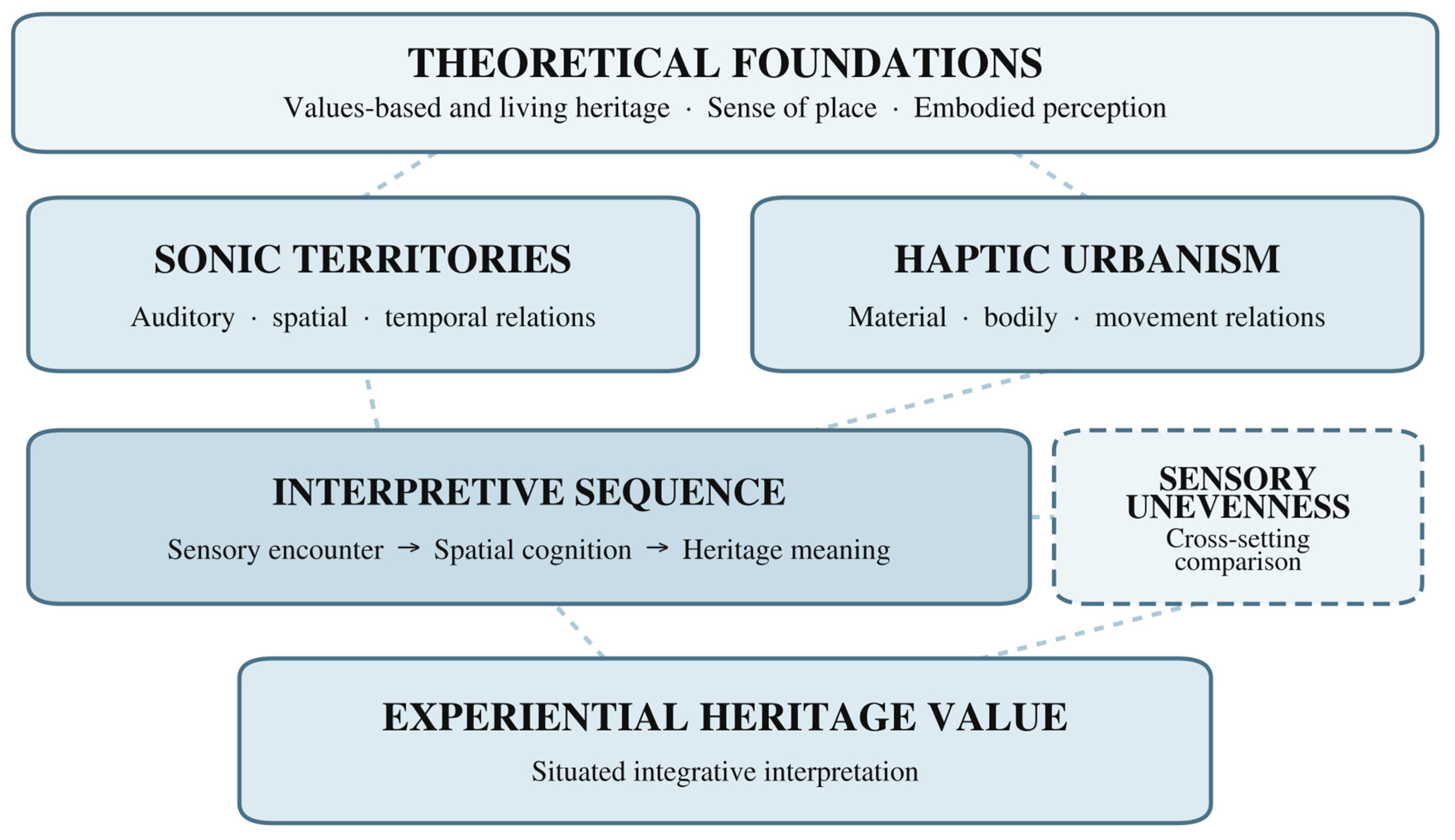
Within this framework, experiential heritage value is the overarching interpretive construct. Sonic territories and haptic urbanism provide data-near analytical dimensions: the former organises auditory, spatial, and temporal relations, whereas the latter addresses tactile, kinaesthetic, thermal, and spatial relations among bodies, materials, and thresholds. Sensory unevenness integrates these dimensions with publicness and observed access conditions to compare route settings. Because the evidence comes from two author–walkers, the framework supports a situated professional interpretation rather than a claim to community consensus. Figure 3 presents these relationships as interpretive rather than causal or quantitative.

3. Methodology

3.1. Research Design: Exploratory Researcher-Led Paired Sensewalking

This research was designed as a pilot, exploratory qualitative case study employing one researcher-led paired sensewalk. The two authors were both the walkers who generated the field material and the researchers who subsequently coded and interpreted it. Sensewalking was understood as a mobile sensory–spatial method that directs attention to how places are perceived through the body while moving, rather than treating urban and heritage environments primarily as visual and static objects [72]. Following the soundwalking lineage, environmental listening was treated as intentional urban observation rather than incidental accompaniment [19,20,64]. The design tests a bounded interpretive approach; it does not estimate stable neighbourhood conditions or explain the mechanisms and impacts of urban transformation. Walking methods also contribute to qualitative inquiry in other disciplinary settings, including criminology [73].
In operational terms, sensewalking combines movement along a route, deliberate but open sensory attention, and contemporaneous documentation of perceptions and their spatial context. In this study, these components were implemented through a predetermined route, walking notes, photographs, environmental sound recordings, and in-walk dialogue. Following soundwalk and smellwalk precedents, perception was treated as spatially and temporally situated; the haptic emphasis further extended attention to texture, vibration, thermal exposure, balance, proprioception, effort, and the bodily negotiation of surfaces and obstacles [4,15,16].
The method corresponds with methodological guidance suggesting that sensory surveys may be conducted individually, in groups, or by two researchers. Paired or duo sensewalks can be undertaken silently or through live discussion, with the latter allowing perceptions to be temporally and spatially contextualised as they emerge [5]. In the present study, conversation was deliberately retained because the objective was not to isolate two supposedly independent sensory responses. Instead, the study examined how knowledge of Bomonti’s transformation was mobilised, compared, questioned, and jointly interpreted during movement. Consequently, the authors’ accounts are understood as dialogically produced and potentially mutually influential.
The research focused on auditory and haptic experience while acknowledging that sensory modalities cannot be completely separated. Auditory experience may be shaped by spatial configuration, traffic, and concurrent visual and olfactory conditions [57], while haptic experience includes more than intentional hand-based contact. It may also involve surface texture underfoot, bodily movement, balance, gradient, vibration, temperature, exposure to sunlight, shade, and the negotiation of thresholds or obstacles [4]. The study therefore employed “haptic” in this broader embodied sense. Its aim was not to produce a complete multisensory inventory but to investigate how Bomonti’s changing architecture and everyday life became audible and bodily perceptible.
The bounded design was appropriate to the methodological aim of testing whether a shared route and cross-referencing of written, aural, and visual materials could disclose relationships between sensory encounter and heritage interpretation. Holding route and time frame constant supported joint contextual interpretation by the two author–walkers. It did not permit claims about Bomonti’s general or enduring sonic and haptic conditions. Repeated walks across times of day, weekdays and weekends, seasons, user densities, and event conditions would be required for that purpose. The study is therefore presented as an exploratory pilot rather than a representative sensory survey.
The overall methodological design, including the fieldwork conditions, data sources, analytical procedures, and interpretive scope, is summarised in Table 1.

3.2. Study Area and Walking Route

Bomonti was selected because its contemporary built environment contains closely adjoining industrial heritage, adaptive reuse, older residential and commercial fabric, and property-led high-rise redevelopment. The route was designed as a transect across these coexisting built outcomes of documented change. It connected inherited institutions and industrial structures with cultural reuse, changing street interfaces, construction, and tower development. This proximity permitted comparison of acoustic character, material continuity, thresholds, permeability, publicness, and pedestrian conditions; it did not provide longitudinal evidence of how the underlying planning, investment, displacement, or socio-spatial mechanisms operated [2,22,23].
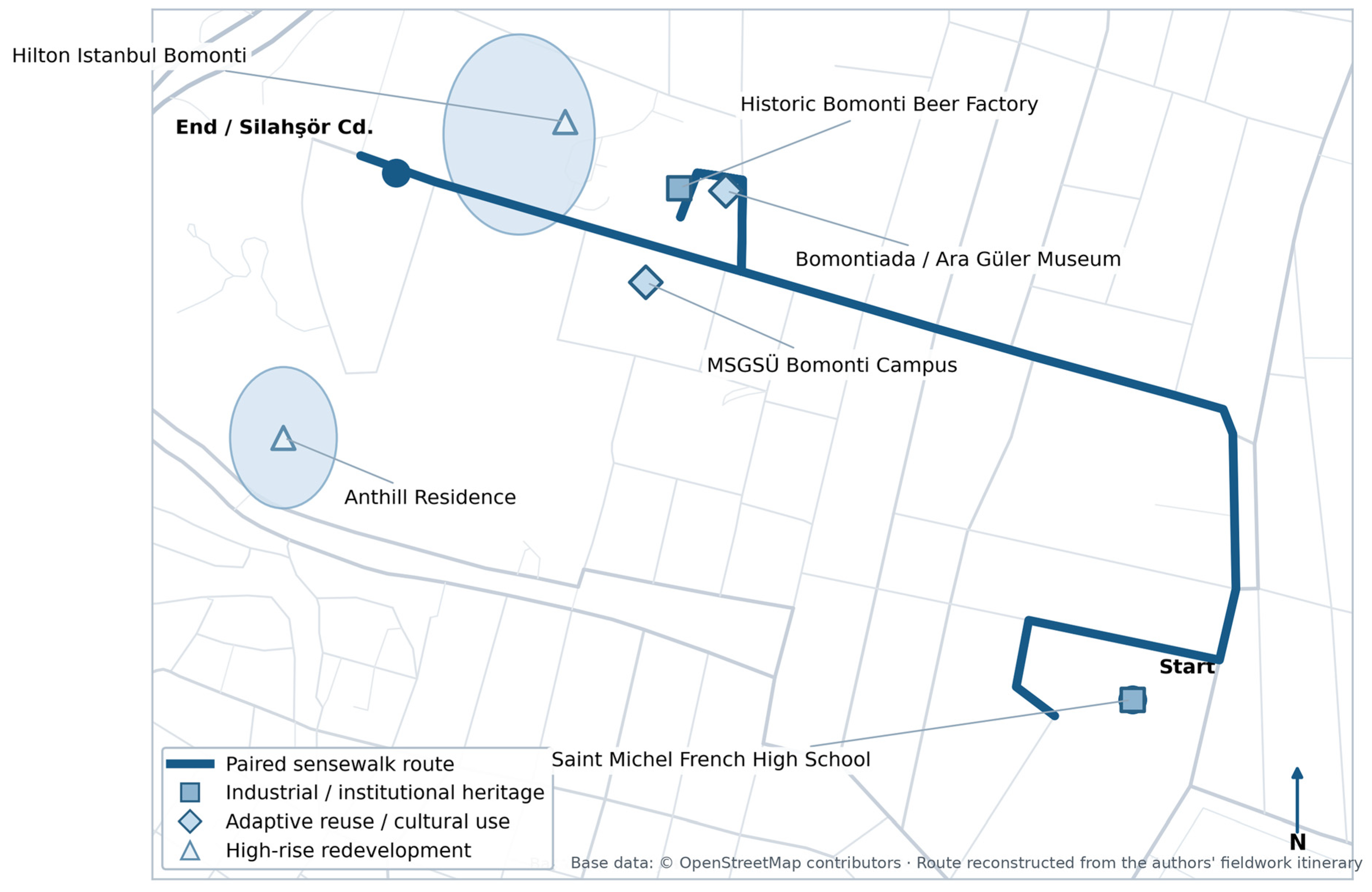
Both authors followed the same predetermined route of approximately 1–1.5 km through Bomonti [74]. It began at Saint Michel French High School, passed through older residential and commercial streets, approached the historic Bomonti Beer Factory and the adaptively reused Bomontiada/Ara Güler Museum complex, connected with the Mimar Sinan Fine Arts University Bomonti Campus, and continued toward Silahşör Caddesi and the high-rise redevelopment interface. Pauses for recording, photography, notes, sketches, and discussion were opportunistic rather than fixed stops. Figure 4 locates these heritage, reuse, and redevelopment settings.
The route map (Figure 4) is interpretive rather than a record of instrumentally geocoded observations: it situates the fieldwork itinerary in relation to key built-heritage and redevelopment landmarks. Figure 4 was generated/illustrated with technical assistance from OpenAI’s ChatGPT (GPT-5.6). The mapped categories distinguish heritage or institutional sites, adaptive-reuse and cultural destinations, and high-rise redevelopment so that the sensory findings can be read against Bomonti’s changing urban structure [2,24].
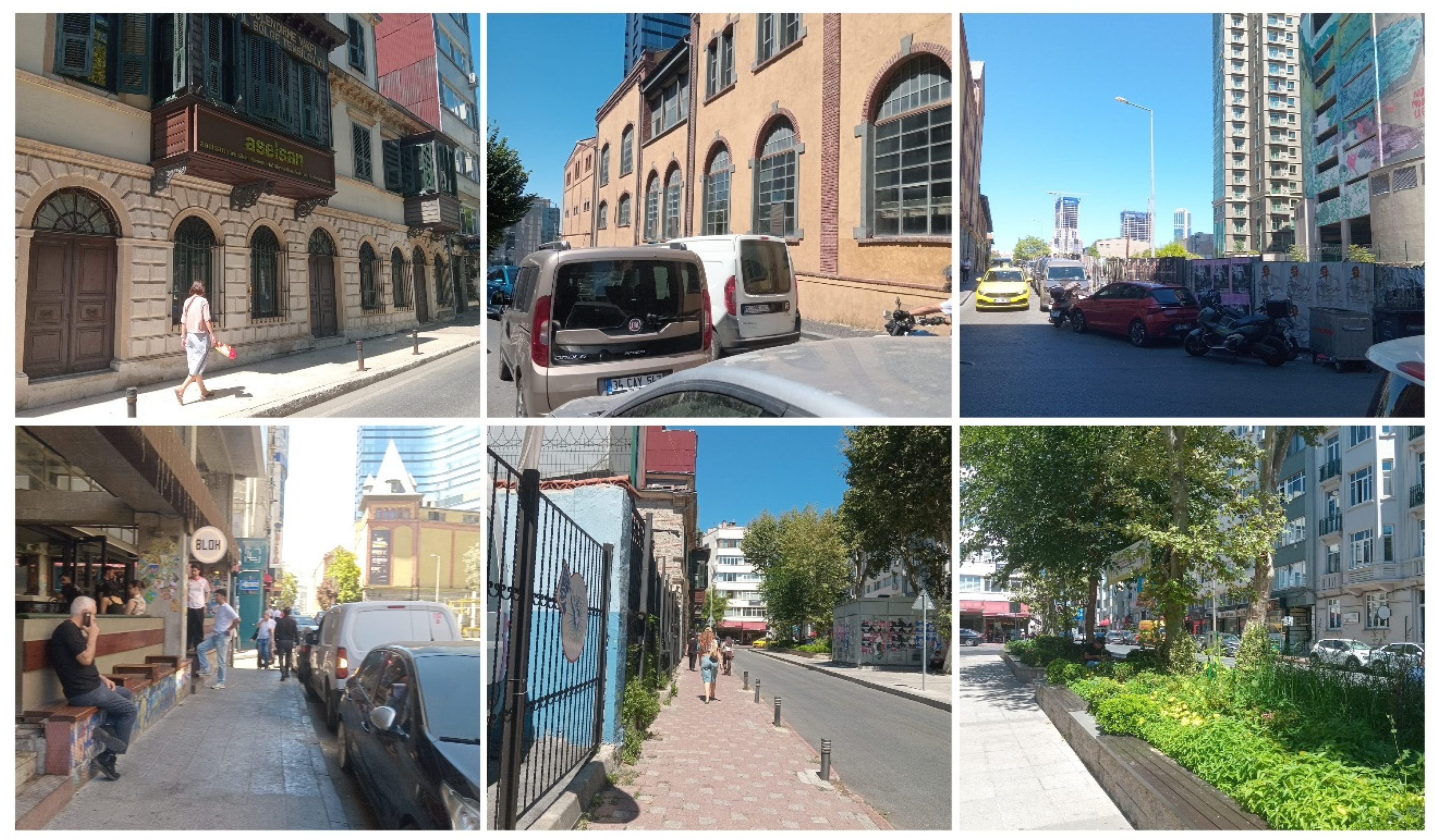
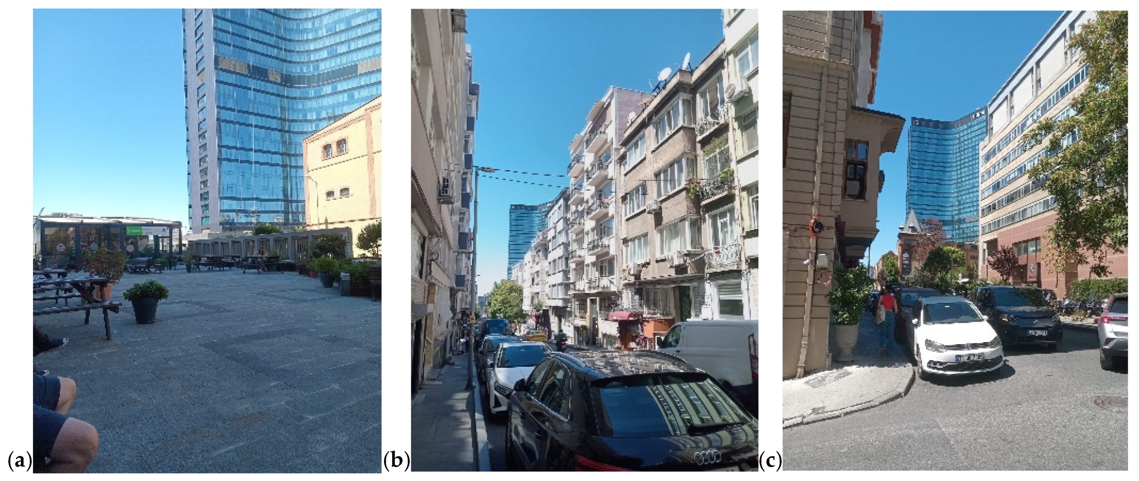
The route’s close succession of reused industrial fabric, older residential buildings, and contemporary high-rise development is illustrated in Figure 5. The photographs establish spatial and material context for the walk; they are not treated as direct evidence that a particular sound was heard or a surface was touched.
Fieldwork was undertaken on a weekday in summer 2026 between 13:00 and 16:00. Recording this temporal context was important because sensory environments vary according to season, weather, traffic, commercial activity, pedestrian density, vegetation, and time of day [5]. Strong afternoon sunlight, shaded street sections, heated surfaces, and differences in pedestrian and vehicular activity formed part of the conditions under which the route was experienced. The results should therefore be understood as an account of Bomonti during a summer weekday afternoon rather than as a description applicable to evenings, weekends, colder seasons, or event periods.

3.3. Author–Walkers and Fieldwork Conditions

The exploratory researcher-led paired sensewalk was undertaken by the two authors, both of whom have backgrounds in design and related disciplines and prior familiarity with Bomonti. This familiarity supported recognition of industrial heritage, architectural change, and shifts in use, but it also shaped what appeared noteworthy. Consistent with reflexive accounts of researcher positionality, situated knowledge was treated as both an analytical resource and a source of selectivity [18,76,77].
Researcher positionality was considered across observation, documentation, and interpretation. Design training plausibly foregrounded materials, facades, spatial proportions, pavements, thresholds, access, and architectural contrasts, while familiarity supplied historical expectations and memories. During analysis, professional knowledge was treated as a situated lens rather than neutral expertise: contemporaneous sensory evidence was distinguished from later contextual interpretation, and photographs alone were not treated as proof that a sound was heard or a surface touched. Reflexivity cannot remove this selectivity; it makes its basis and consequences explicit [76,77]. The findings are therefore expert, author-generated interpretations whose questions and procedures may be transferable, not neutral perceptions representative of residents or other user groups. Moldes similarly frames the researcher as a site of embodied knowledge in walking research [78].
The authors walked together and discussed sounds, surfaces, spatial transitions, and everyday activities as they arose. Their conversation was captured in the two continuous MP3 route recordings and cross-referenced with contemporaneous walking notes. Because conversation could shape subsequent attention, the material was treated as jointly produced rather than as two independent accounts. During coding, the authors marked episodes of shared interpretation, divergent appraisal, uncertainty, and explicit attention direction. Examples retained in the Findings include one author’s characterisation of Bomontiada as a neighbourhood ‘heart’ followed by the other’s qualification concerning managed and consumption-dependent publicness, and the phrase ‘the neighbourhood’s slopes,’ which redirected attention from landmark form to pace and bodily effort. People incidentally visible in photographs were not treated as research participants or analysed individually.

3.4. Data Collection, Organisation, and Analysis

Three principal forms of field material were produced: field notes with simple sketches, 55 unique photographs, and two continuous MP3 route recordings of approximately 45 min each. The notes included both descriptive observations of the perceived environment and interpretive sonic and haptic accounts, recording sounds, bodily movement, surfaces, spatial conditions, architectural contrasts, and everyday activity. The MP3 files captured environmental sound and the authors’ in-walk conversation along the route. During analysis, selected conversational passages were transcribed in Turkish, checked against the field notes, and translated into English by the authors. The quotations are translated excerpts from recorded in-walk conversation, lightly edited for readability without changing meaning.
Environmental audio and in-walk conversation were documented in two MP3 route recordings, each approximately 45 min long (approximately 90 min of recorded material in total). The broader 13:00–16:00 field period also included stationary note-making, sketching, photography, and pauses. During familiarisation, both authors replayed the recordings together and examined identifiable source type, continuity or interruption, rhythm, apparent proximity, conversational interpretation, and correspondence with field notes, sketches, photographs, and spatial context. The recordings were not calibrated and were not used for sound-pressure measurement or acoustic modelling. The recording-device model was not retained in the analytical documentation and is therefore reported as unavailable rather than reconstructed retrospectively.
The analytical photographic corpus comprised 55 unique photographs. The photographs did not retain usable GPS or original capture-time metadata and could not independently reconstruct the exact route sequence. Each image could receive more than one visual code. The photographs were examined for visible spatial and architectural content and cross-referenced with the route, field notes, sketches, and documented sound observations where possible.
Table 2 reports the extent of each data source and its evidentiary limits. Where metadata were not retained, the table states this directly rather than introducing retrospective estimates.
Photographic analysis concentrated on four connected groups of features. First, built-form characteristics included industrial masonry, reused heritage buildings, older and mid-rise residential fabric, contemporary commercial buildings, and high-rise towers. Second, material and haptic features included cobblestone, asphalt, concrete, brick paving, tactile paving, stone and plaster walls, metal elements, thresholds, shaded areas, and sun-exposed surfaces. Third, movement conditions included pavement width, gradient, surface transitions, parked vehicles, bollards, street furniture, pedestrian crossings, and other elements affecting bodily negotiation. Fourth, visible sound-related contexts included automobiles, taxis, motorcycles, pedestrians, cafes, shops, market displays, commercial activity, and construction. These were coded as contextual indicators of possible sound production, not as proof that a specific sound had been heard.
Coding followed a hybrid deductive–inductive strategy. Initial sensitising codes were derived from the research questions and literature on soundwalking, haptic experience, movement, thresholds, adaptive reuse, and publicness. During repeated familiarisation, these were refined through data-led attention to memory, comfort and disturbance, thermal exposure, everyday activity, architectural change, and relations among source types. Both authors reviewed and coded the materials collaboratively from the outset rather than producing independent codebooks. Candidate interpretations were discussed against the relevant note, recording, and photograph; definitions were revised through reasoned consensus. The reflexive approach sought interpretive coherence rather than coder interchangeability [79]; no statistical inter-coder coefficient was calculated because coding was collaborative rather than independent. Cross-source review and explicit discussion of coding decisions were intended to support analytical transparency, consistent with qualitative trustworthiness guidance [80].
Photographs were then compared with written and recorded material. A photograph could contextualise the spatial enclosure, surface, traffic condition, building type, or activity associated with a note or sound recording, but it was not treated as direct evidence of auditory or haptic experience. Similarly, the visibility of a stone wall did not demonstrate that it had been physically touched, and the presence of a motorcycle did not prove that its engine was audible at the moment of photography. Interpretations of sound and touch were retained only when supported by walking notes, the authors’ dialogue, sound recordings, or an explicit description of bodily experience.
The materials were then synthesised around encounters and transitions along the route. Cross-source convergence strengthened interpretation, while missing or conflicting support required narrower wording. The recorded conversation and field notes were also coded for shared interpretation, divergent appraisal, uncertainty, and explicit attention direction. These interaction codes were used qualitatively to examine how perception was negotiated, not to calculate agreement rates. The process produced two data-near themes—sonic territories and haptic urbanism—and the higher-order comparative interpretation of sensory unevenness.
Table 3 summarises the principal coding families, definitions, permitted evidence, and illustrative observations used in this cross-modal analysis.
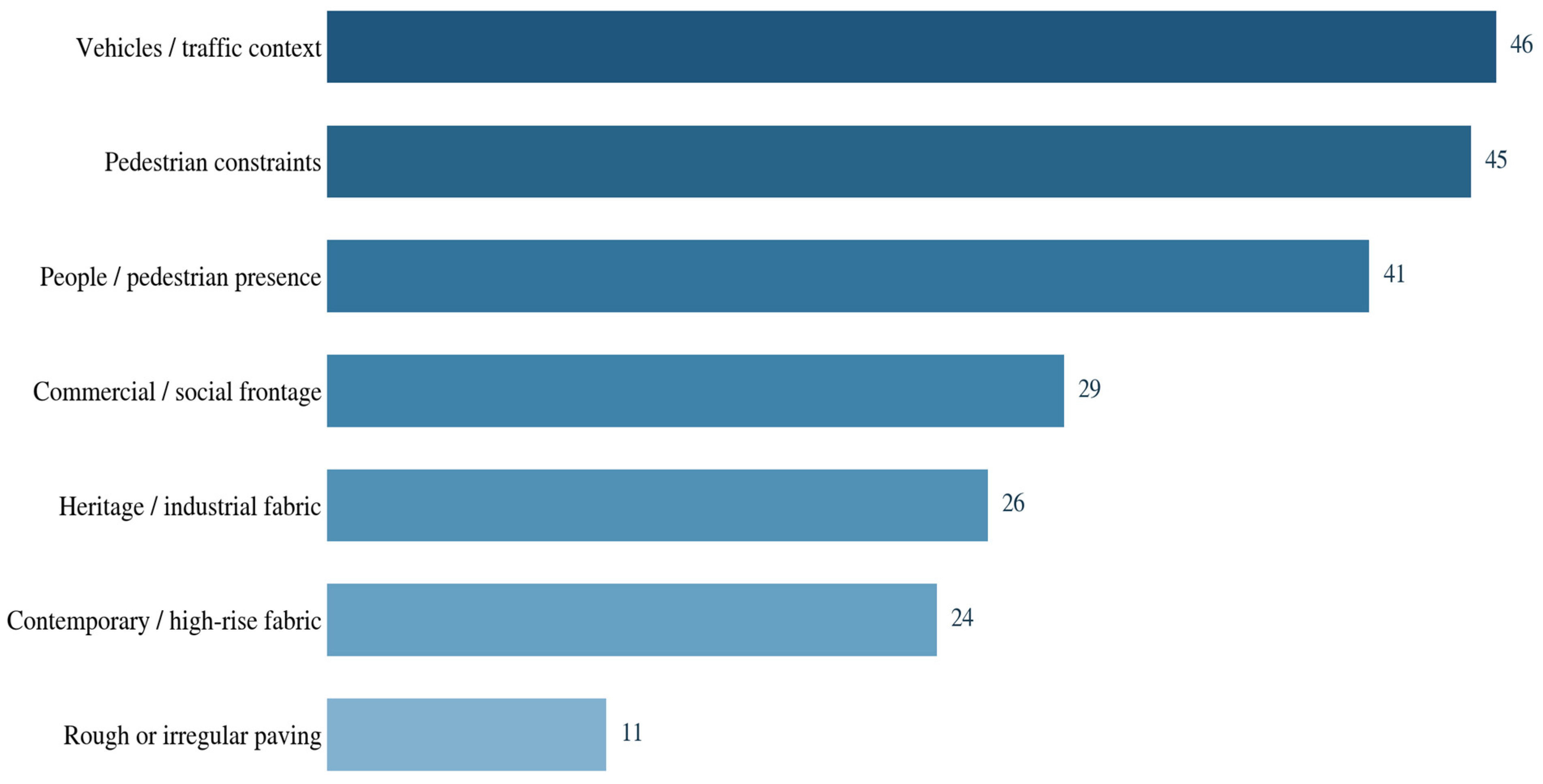
Figure 6 reports the non-exclusive visual codes across the 55 unique photographs: vehicles/traffic context (n = 46), pedestrian constraints (n = 45), people/pedestrian presence (n = 41), commercial/social frontage (n = 29), heritage/industrial fabric (n = 26), contemporary/high-rise fabric (n = 24), and rough/irregular paving (n = 11). One photograph could receive multiple codes. The counts describe visible contexts only and do not indicate the frequency or intensity of auditory or haptic experience.
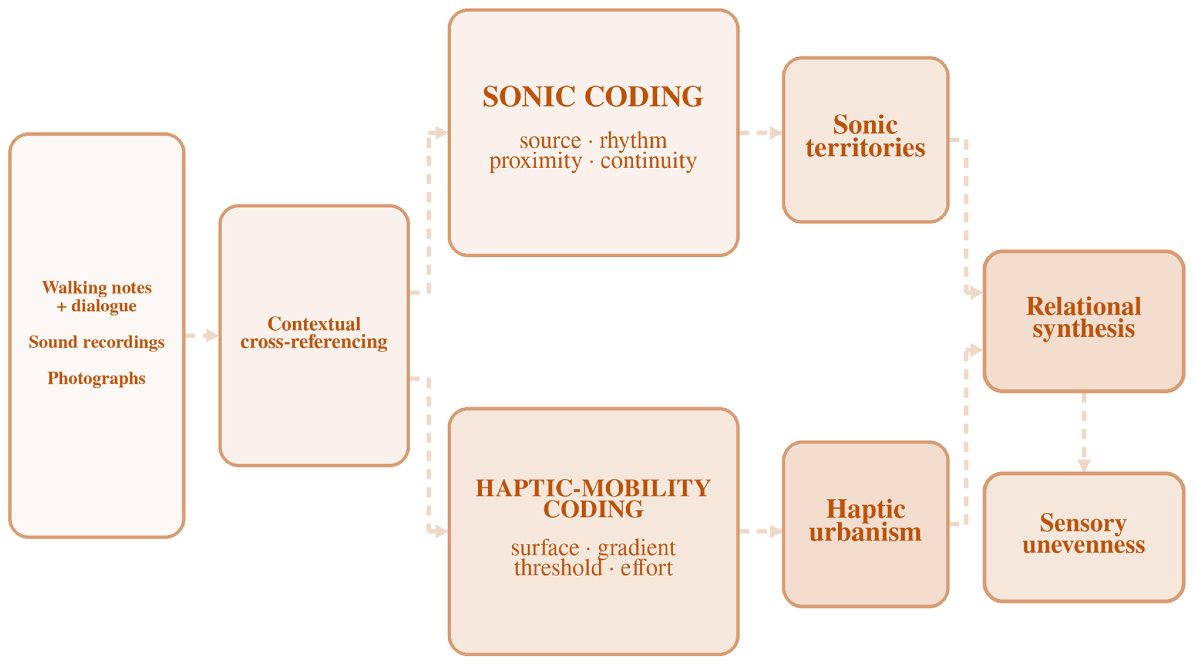
The analytical sequence is summarised in Figure 7. Rather than treating each source as an independent record, the three materials were contextually cross-referenced, reviewed for corroboration and evidentiary limits, and coded through sonic and haptic-mobility categories. This joint reflexive process produced the themes of sonic territories and haptic urbanism and the higher-order interpretation of sensory unevenness.

4. Findings

4.1. Sonic Territories Across Coexisting Urban Layers

Evidence types are differentiated throughout this section. An auditory observation denotes a sound documented in the field notes and/or the two continuous MP3 route recordings. A visible potential sound-producing context denotes only a source or activity visible in a photograph and is not treated as evidence that a sound occurred. Photographs contextualise street geometry, activity, and possible sources; they do not establish auditory events.
Within the bounded field period, the route did not present a single, continuous Bomonti soundscape. Field notes and the two continuous recordings instead indicated overlapping sonic territories associated with vehicular mobility, commercial and social activity, documented construction sound, and relatively enclosed or sheltered spaces. Transitions could occur within short walking distances. The recorded dialogue included shared observations, divergent appraisals, uncertainty, and attention direction; two concrete episodes are presented below. These examples illuminate co-produced interpretation but do not constitute an independent comparison of two isolated perceptual accounts. Sound is therefore interpreted as a spatially and temporally situated relationship among architecture, movement, and everyday activity, not as a stable characteristic of the neighbourhood.
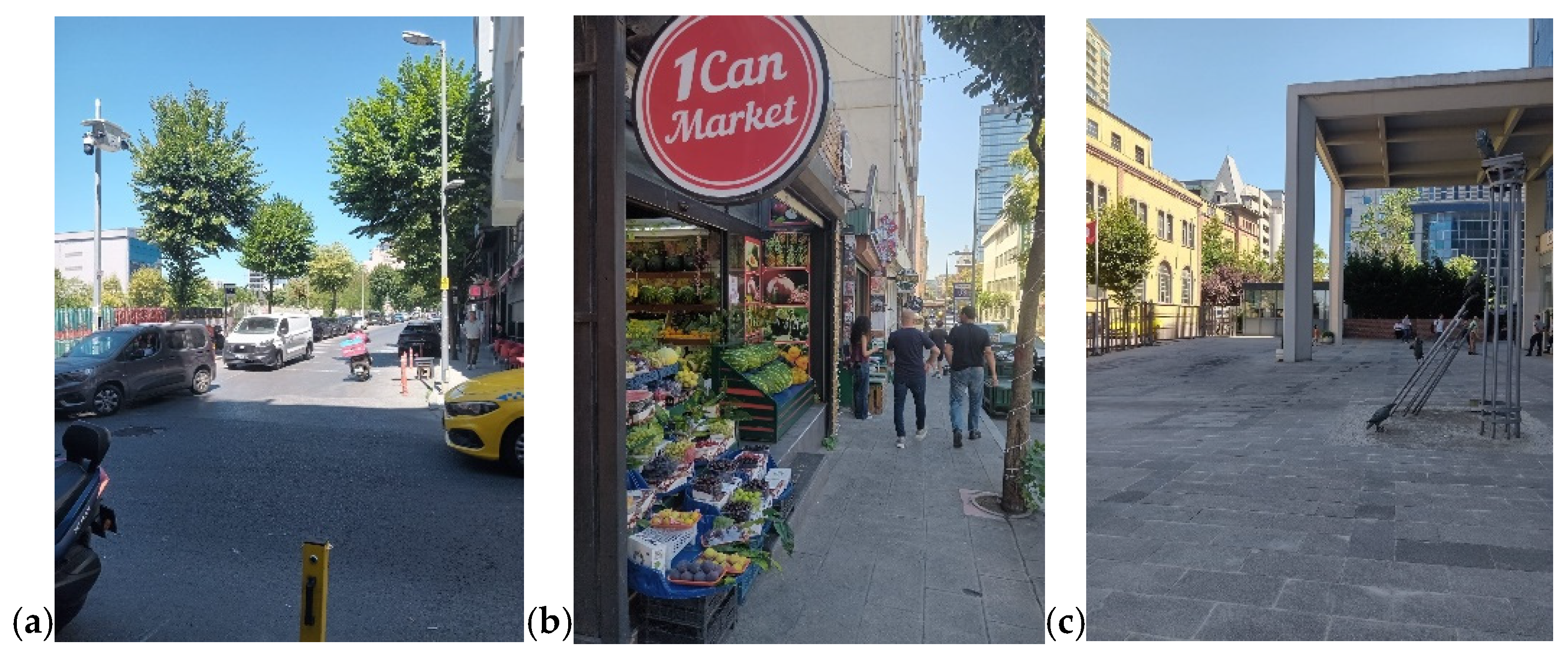
Field notes and the continuous MP3 recordings documented episodes of motorised sound, while photographs contextualised traffic proximity, enclosing facades, pavement width, and junction geometry. These episodes were interpreted in relation to street dimensions, pedestrian proximity, and the separation between pedestrian and vehicular movement.
Photographs also documented cafes, shopfronts, food businesses, market displays, outdoor seating, and pedestrians. These were coded as potential sound-producing contexts only. Voices, service activity, music, or other commercial sounds are discussed as auditory observations only where supported by field notes or the continuous recordings. The supported observations were intermittent and encounter-dependent: voices approached and receded, and street or interior activity became more or less audible as walkers moved past openings and occupied frontages.
The recorded conversation connected commercial and social activity with proximity, neighbourhood memory, and local cultural associations. One author noted, “A few blocks up this street is the Feriköy market,” and the exchange described Bomonti as having “managed to preserve its historically cosmopolitan structure” and as “a living environment with its churches, art galleries, and steep streets” (translated excerpts from recorded in-walk conversation, lightly edited for readability without changing meaning). The passage shows how documented auditory activity was interpreted through remembered institutions and place associations rather than through sound sources alone.
The route also brought the authors into contact with Bomontiada and other settings where industrial structures have acquired cultural, educational, hospitality, or commercial functions. A single walk cannot establish acoustic change longitudinally or reconstruct the former factory soundscape. Instead, present acoustic observations were interpreted in relation to documented functional conversion. Retained masonry and courtyard form provided material-spatial continuity, while field notes and the continuous recordings identified contemporary voices and service or cultural activity at particular moments. The analysis treats this as a situated acoustic identity within reused industrial fabric, not as a complete or enduring account of the site.
The paired record also retained a difference in appraisal. One author described the complex as follows: “Bomontiada, formed through the renewal of the old beer factory, is the heart of the neighbourhood, with its concerts, exhibitions, restaurants, and spaces of socialisation.” The other author then qualified this positive account by drawing attention to managed entry, commercial seating, scheduled events, and the distinction between visibility and unrestricted public access (translated excerpts from recorded in-walk conversation, lightly edited for readability without changing meaning). The episode was coded as divergent appraisal of publicness rather than disagreement about the site’s physical presence. It illustrates how dialogue made interpretation negotiable while avoiding any claim of community consensus.
Construction sites, temporary barriers, equipment, and unfinished surfaces were visually prominent and provided evidence that physical transformation was ongoing. Construction sound is treated as an auditory observation only for route segments where it was documented in notes or the continuous recordings; elsewhere photographs establish construction context, not sound. Where mechanical activity was documented, it made redevelopment perceptible before completed buildings were occupied. This bounded observation supports an interpretation of construction as a provisional route condition, but it does not establish its persistence or neighbourhood-wide acoustic impact.
The quieter or less mechanically active parts of the route should not be understood as acoustically empty. In the field notes and recordings, side streets, walled plots, setback buildings, and reused courtyards were interpreted as acoustic thresholds where traffic became less prominent relative to footsteps, voices, or event-related sounds. In Bomontiada, permeability between street, entrance, courtyard, and interior produced a graded rather than binary transition from public to managed space. By contrast, controlled tower entrances and setbacks could create acoustic distance while offering less opportunity for spontaneous occupation. Within this route-specific interpretation, acoustic shelter, permeability, and publicness were related but not interchangeable qualities. Multimodal research elsewhere supports examining soundscape in relation to spatial and other sensory conditions [56,57]; it does not establish the access or governance conditions observed in Bomonti.
The sonic findings resist a simple opposition in which older Bomonti is quiet and socially authentic while transformed Bomonti is noisy and alienating. Older commercial streets can be acoustically dense, while Bomontiada’s reused courtyards can separate visitors from traffic and concentrate social sound. New towers may introduce construction and service rhythms, yet setbacks can also create distance from the street. Within the sampled route and period, the documented coexistence of transformed settings was encountered through uneven acoustic identities, thresholds, activities, and listening positions. Read alongside accounts of Bomontiada’s cultural conversion [24], the route evidence suggests that industrial fabric can remain publicly recognisable while its sounds and social programme change. Other industrial and institutional remnants along the route presented more variable conditions of access, permeability, and everyday audibility.
Figure 8 shows the traffic, commercial, and enclosed settings within which the corresponding field notes and recordings were interpreted.

4.2. Haptic Urbanism: Material Transitions and Bodily Negotiation

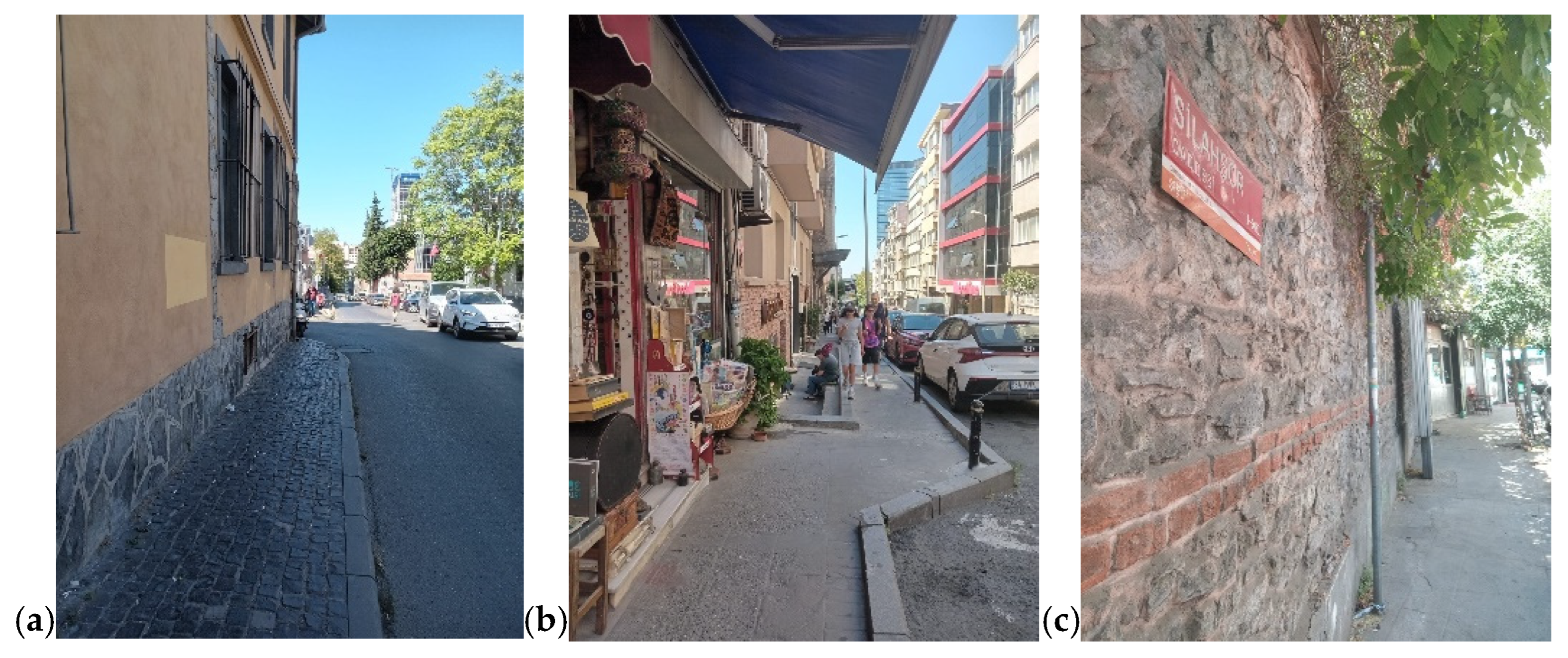
The second principal finding concerns the haptic and embodied character of the transformed Bomonti settings encountered along the route. The photographic corpus documents a route composed of frequent changes among stone paving, cobblestones, asphalt, concrete, brick paving, tactile paving, and repaired or fragmented walking surfaces. The photographs establish these visible surface conditions only. Corresponding field notes and recorded in-walk conversation, rather than the images themselves, provide the basis for interpreting changes in stability, rhythm, anticipated effort, and bodily adjustment. The haptic environment was thus considered through underfoot contact, posture, balance, pace, and movement, as well as deliberate hand contact where documented. This extended understanding of touch is consistent with Parker et al.’s [4] argument that urban haptic experience includes kinaesthetic and bodily relations with space rather than only direct tactile contact.
Ground surfaces were significant because they registered material continuity, repair, and different periods of construction. For the two author–walkers, transitions among rough stone, cobbles, industrial paving, patched asphalt, concrete, tactile indicators, and newer surfaces were interpreted through the notes and recorded dialogue as changes in stability and anticipated effort. Irregular or interrupted surfaces also raise potential accessibility concerns for wheelchair users, people using walking aids, pushchairs, or wheeled luggage. Because no participants from these groups took part, these are researcher observations about physical conditions and possible design implications, not findings about those users’ lived experience. The study did not conduct a standards-based accessibility audit.
Embodied negotiation was also shaped by the organisation of pedestrian space. The images show narrow and interrupted pavements, sloping streets, bollards, parked cars, scooters, street furniture, utility elements, and changes in level. These features frequently reduced the width of the walkable area and positioned the pedestrian close to traffic, building edges, or other obstacles. The notes and recorded dialogue supplied the experiential account of walking decisions: whether to remain on a constrained pavement, step around an object, slow down on an uneven surface, or move temporarily closer to the road. These accounts support the interpretation of bodily adjustments within the sampled route. Photographs indicate available space and visible obstacles, but do not independently establish pace, balance, or experienced effort.
Topography provided a concrete example of attention direction. One author’s phrase “the neighbourhood’s slopes” redirected the shared discussion from landmark form toward route choice, exertion, pace, and proximity to everyday destinations (translated excerpts from recorded in-walk conversation, lightly edited for readability without changing meaning). The exchange was coded as mutual guidance: gradient became not only a visual feature but a bodily and orienting condition.
Vertical surfaces produced another important haptic contrast. The brick and masonry of the historic brewery and other industrial buildings provided material continuity through roughness, scale, weathering, and bodily proximity, while glass curtain walls, smooth cladding, polished entrances, and tower lobbies signalled a different regime of touch and approach. Even without direct hand contact, surface depth, apparent porosity, distance, and enclosure shaped anticipated haptic experience. While the reuse literature addresses the retention and interpretation of industrial fabric [1,2,3], the present route-based reading asks whether walkers could approach, cross, and occupy the associated surfaces and spaces. In this interpretation, material preservation without permeability could leave heritage visually present yet bodily remote.
Er’s reconstruction helps specify the historical meaning of the material heterogeneity observed during the walk. At the brewery, transitions among stone masonry, brickwork, concrete structure, modified openings, and connected blocks resulted from successive technological and functional adaptations rather than from a single opposition between ‘historic’ and ‘new’ fabric [22]. The walkers’ perception of roughness, depth, enclosure, and changing proximity can thus be interpreted as contact with an accretive industrial palimpsest. This interpretation remains cautious: the sensewalk made exposed surfaces and spatial relations perceptible, whereas archival and architectural research identifies concealed construction phases and former functions that cannot be inferred from sensory evidence alone. Read together, the two forms of evidence distinguish embodied material continuity from a merely stylistic industrial atmosphere.
Figure 9 contextualises the haptic findings by showing changes in paving, pavement width, geometry, building edges, and surface texture associated with documented bodily adjustments.
The fieldwork conditions added a thermal dimension to these material relationships. Sun-exposed stone, asphalt, glass, and metal presented a different bodily environment from shaded pavements, tree-covered sections, recessed entrances, and enclosed courtyards. Photographs document visible sun–shade contrasts, not surface temperature or bodily thermal response. Thermal interpretations are drawn from the field notes and recorded conversation about exposure and shade; no temperature or physiological measurements were made. Relationships with pace, fatigue, and material conditions are therefore treated as situated interpretations rather than measured thermal effects. This illustrates why multisensory field protocols need to record environmental conditions together with spatial and material observations [5].
Thresholds between public, semi-public, and controlled spaces further shaped the haptic experience of transformation. At Bomontiada, the sequence from street to entrance and courtyard permitted visual and bodily approach to retained industrial fabric and supported gathering, although commercial terraces, event programming, and management produced selective publicness. At other industrial, institutional, and high-rise sites, gates, steps, kerbs, security boundaries, recessed lobbies, and setbacks more sharply regulated entry. Permeability therefore concerned more than an open gate: it included the continuity, legibility, comfort, and observed physical accessibility of the route across a threshold. Within the sampled settings, transformation was materially legible in what could be approached or touched and which courtyards appeared occupiable. Differences in steps, kerbs, gates, and route continuity indicated potential variation in independent movement, but implications for particular users were not tested.
As with the sonic findings, the material evidence does not support a simple opposition between a sensorially rich ‘old’ Bomonti and a smooth, detached ‘new’ Bomonti. Industrial masonry and rough paving may sustain material continuity while raising comfort or access questions; newer paving may facilitate movement while leading to controlled interiors. The haptic strand of route-specific sensory unevenness concerns material continuity, thresholds, permeability, publicness, and observed movement conditions. The observed conditions identify questions for future participant-based research and a dedicated accessibility assessment; they do not establish exclusion or the lived experience of particular mobility groups.
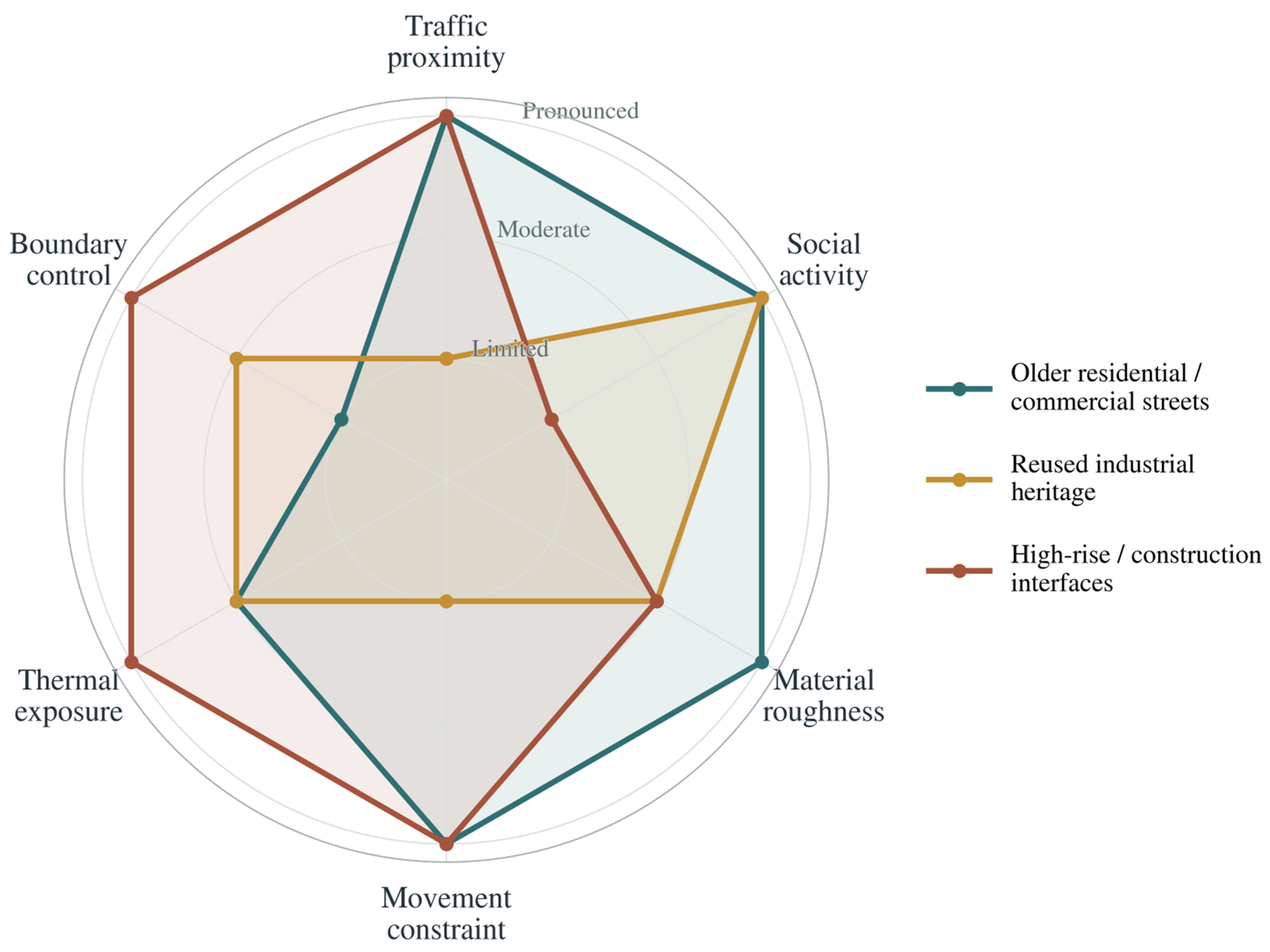
Figure 10 brings the two strands of findings together through an ordinal qualitative comparison of three recurring settings: older residential/commercial streets, reused industrial heritage, and high-rise/construction interfaces. Levels were assigned jointly after setting-specific cross-source review. Limited denotes isolated or peripheral evidence within the relevant material; moderate denotes recurrent but variable or context-dependent evidence; and pronounced denotes repeatedly salient evidence for that setting. A photograph alone could not establish an auditory event or direct haptic experience. The profiles describe prominence in the reviewed material, not environmental prevalence. They are interpretive summaries, not measurements, frequencies, respondent ratings, or equal-interval scales; distances and enclosed areas in the radar display have no quantitative meaning. The six plotted characteristics are setting-specific operational indicators; they are not a one-to-one restatement of the five composite dimensions through which sensory unevenness is defined in Section 5.1.

5. Discussion

5.1. Sensory Unevenness Across Coexisting Urban Layers

The discussion addresses the two research questions in sequence. Section 5.1 interprets the route-specific sonic and haptic qualities identified for the first question through sonic territories, haptic urbanism, and sensory unevenness. Section 5.2 addresses the second by explaining how these encounters became relevant to experiential heritage value when interpreted through spatial cognition, documentary history, present use, memory, and access. The argument remains bounded to one exploratory walk and does not infer general sensory conditions or causal mechanisms of urban transformation.
Read alongside documented historical and morphological research, the route-specific findings are consistent with an interpretation of Bomonti’s transformation as more than a linear replacement of an industrial neighbourhood by a completely new residential, commercial, and cultural district. Older apartment buildings, industrial structures, small businesses, construction sites, cultural venues, and high-rise developments coexist within short spatial intervals. This juxtaposition makes different phases of urban development simultaneously present in the walking experience. The recurrent visual relationship between masonry industrial structures and glass towers is therefore more than an architectural contrast: it expresses the uneven temporality of transformation. This interpretation corresponds with research describing Bomonti as a neighbourhood in which different social and morphological worlds remain side by side despite their limited interaction [39].
Reading the walk against Er’s district-wide inventory also clarifies why the “multiple Bomontis” are not reducible to industrial heritage versus high-rise redevelopment. Saint Michel French High School, Catholic churches, minority institutions, water infrastructure, early apartments, garden houses, factories, workshops, and informal housing belong to overlapping phases of the same urban formation [22]. Their differing setbacks, walls, entrances, street relations, materials, and programmes suggest different spatial possibilities for audibility, approach, and bodily passage; this is an interpretation of documented form, not a reconstruction of historical sensory experience. The contemporary sensory sequence therefore registers not only deindustrialisation but a reorganisation of a long-standing mixed urban ecology. This reading prevents the brewery from becoming the sole historical anchor and situates Bomontiada within a broader network of inherited institutional and everyday spaces.
Rather than a catalogue of isolated sounds or surfaces, the answer to the first research question lies in the relationships among them. Documented activity, acoustic shelter, material continuity, bodily effort, and controlled thresholds combined differently across settings, producing overlapping sonic territories and haptic relations. This pattern extends the morphological account above from visible coexistence to embodied encounter.
Industrial heritage scholarship emphasises that heritage making after deindustrialisation selectively retains, reframes, or erases material and social pasts [44]. Sensory research adds that rust, dust, smoke, smell, and acoustic traces can act as memory-bearing cues, but their significance depends on how they are decoded through history, use, and social association rather than on sensory intensity alone [6,46,48,49,50]. At Bomontiada, retained masonry and courtyard form, contemporary cultural programming, street traffic, and managed entry formed one such interpretive constellation. It kept the industrial complex publicly recognisable while recoding productive space as a cultural and hospitality setting. Although Eglīte addresses creative industries more broadly, her account of senses and emotion in the experience economy helps clarify the resulting tension: sensory activation can support engagement while also organising experience through consumption [52]. The route evidence does not resolve that tension for all users; it makes the relationship among industrial memory, current programme, and conditional publicness analytically visible.
Historical cross-reading also makes absence analytically visible. Er documents the former Nestlé Chocolate Factory on the parcel now occupied by Elysium Residence and traces the Odeon–Orfeon record factory from its depiction on Pervititch maps to its disappearance between the 1972 and 1982 aerial records [22]. These sites cannot contribute material texture or industrial enclosure to the present walk in the same way as reused fabric; their industrial histories survive primarily through maps, photographs, and documentary reconstruction. The high-rise and office interfaces encountered along the route should therefore be read not simply as additions beside heritage, but in some locations as replacements in which earlier industrial sensory affordances are no longer materially available. This distinction is central to experiential heritage value: reused, fragmentary, and erased industrial sites produce fundamentally different relationships among memory, perception, and access.
Construction-related contexts made this relationship provisional rather than complete. Spatial narrative scholarship argues that industrial heritage protection depends partly on how spatial sequences communicate historical layers and present functions [45], while research on interactive experience journeys in renovated industrial sites examines the design of visitor engagement [51]. The temporary barriers, unfinished surfaces, altered pedestrian routes, and documented mechanical sound encountered in Bomonti presented a less curated spatial narrative: transformation was interpreted as incomplete and in progress. This remains a route-specific reading, not longitudinal evidence of redevelopment effects.
Sensory unevenness synthesises the route-scale answer to the first research question across five linked dimensions traced in the coding: acoustic exposure and shelter; material stability and movement demand; thermal exposure and shade; permeability and boundary control; and opportunities for lingering, social audibility, and participation. In the dataset, these appeared through documented traffic or social sound, transitions among surfaces and gradients, sun–shade contrasts, street-to-courtyard sequences, and differences between permeable and controlled thresholds. Unlike environmental-justice, mobility-justice, and disability-access scholarship, which examines the distribution of harms, mobility capabilities, governance, and differently situated users [81,82,83], this two-author pilot cannot demonstrate distributive injustice or sensory exclusion. The concept identifies where experiential conditions changed and which spatial relations contributed to those differences; whose participation they enable or constrain remains a question for participant-based research.
This unevenness prevents an uncritical celebration of either historical texture or contemporary redevelopment. Rough masonry, cobblestones, weathered facades, and small-scale commercial activity may strengthen material continuity and local distinctiveness, yet irregular surfaces and constrained pavements were observed as conditions that may affect comfort or create potential barriers. Conversely, newly constructed spaces may provide smoother surfaces and more clearly defined entrances while simultaneously establishing controlled boundaries and privatised environments. The sensory distinction between old and new is therefore ethically and spatially ambiguous. The findings support an interpretation of Bomonti as a layered urban environment in which heritage, consumption, everyday life, and property-led development coexist but present different observed combinations of route continuity, boundary control, and sensory exposure. Whether these differences produce unequal access or comfort for particular users remains a question for participant-based research. These coexisting conditions are illustrated in Figure 11.

5.2. Experiential Heritage Value and Implications for Conservation and Adaptive Reuse

Retained masonry, courtyard sequences, paving transitions, gates, and changing acoustic fields acted as sensory cues; movement and perceptual memory organised them into spatial understandings of continuity, enclosure, proximity, permeability, and separation. Work on heritage decoding similarly places ambiance and perception between material evidence and cultural interpretation [47], while sensory heritage scholarship treats embodied experience as a way of investigating how the past is encountered rather than as automatic proof of significance [48,49,50]. Read alongside documentary history and present use, the route-specific understandings supported provisional meanings concerning industrial continuity, functional change, and conditional publicness. Experiential heritage value names this mediated relationship. The analysis does not establish community social value or a collectively shared sense of place. The social-value scholarship emphasises the importance of engaging with community meanings [12,67], while place attachment concerns a broader relationship between people and place [66].
For conservation and adaptive reuse, the sonic findings connect with arguments for treating acoustics as an embodied heritage concern [6] and soundscape as a place-making resource at industrial heritage sites [7]. The implication is not to reconstruct an unknowable factory soundscape or equate audibility with authenticity. It is to examine how retained volumes, masonry, openings, courtyards, new services, cultural programming, and traffic exposure mediate recognition of industrial continuity and present use. At Bomontiada, the route evidence showed partial acoustic separation from traffic and a concentration of contemporary social activity at a particular time; whether this supports heritage meaning depends on how different users interpret the relation between fabric, programme, and publicness. We therefore propose pre-design and post-occupancy sensewalks, informed by sensory documentation protocols [5], as a way to investigate that relationship. Their value for evaluating reuse would need to be tested in future applications.
The haptic findings identify conditions for future inclusive investigation rather than constituting an accessibility assessment. Surface continuity, gradients, kerbs, steps, and thresholds were recorded as physical conditions that may affect bodily effort and route choice; because wheelchair users and people using mobility aids did not participate, consequences for particular groups cannot be reported as lived findings. Accessibility is therefore considered alongside acoustic character, material legibility, social use, memory, permeability, and publicness rather than treated as a singular measure of heritage success. Disability-access and mobility-justice scholarship underlines the importance of differently situated users [82,83]. For future applications, we therefore propose participatory walks involving diverse mobility and sensory profiles, together with a dedicated accessibility audit, before specifying interventions for particular groups.
The cross-modal implications can also be placed alongside work on interactive experience journeys in renovated industrial sites [51] and restorative perception in industrial heritage regeneration [53]. The present study assessed neither a designed interactive experience nor health outcomes; it identifies sensory–spatial conditions that such research could test. Hard surfaces can mediate both foot contact and acoustic reflection; gates can influence touch, movement, sound transmission, and public access; and shaded courtyards can connect thermal comfort with opportunities for lingering and social audibility. Adaptive-reuse evaluation should therefore examine connected street–threshold–courtyard–interior–neighbourhood sequences rather than treat material, acoustic, thermal, and access conditions as separate checklists.
These implications become clearer when conservation is assessed beyond the individual building. Er [22] reports that while principal brewery buildings acquired cultural and hospitality functions, parts of the wider complex were assigned new institutional ownership, ancillary structures were demolished, and a hotel came to occupy part of the former factory site. Read with the present sensory findings, this history shows that physical preservation and experiential continuity are not equivalent. A conserved block may remain publicly recognisable while the production ensemble, circulation logic, open-space relationships, or neighbourhood connections become less legible. Conservation briefs should consequently document the relational heritage of the whole complex: how blocks connect, how courtyards organise movement and sound, how industrial surfaces meet accessible routes, and how thresholds mediate public entry. The appropriate unit of assessment is the street–ensemble–neighbourhood sequence rather than the isolated facade [2,37].
The paired format supported contemporaneous dialogue and joint contextual interpretation. The recorded exchange about Bomontiada retained a divergent appraisal of publicness, while the remark about ‘the neighbourhood’s slopes’ documented attention direction from landmark form toward bodily effort. These cases show how perception was negotiated in motion, although they do not support frequency claims or a reliability comparison between independent perceivers. Future applications could combine separately documented individual walks with subsequent paired comparison and include residents, workers, visitors, and people with diverse mobility and sensory profiles.
The study connects industrial heritage transformation and interpretation [44,45] with mobile sensory inquiry [4,5] and values-based heritage approaches [11,12,13]. The framework operationalises that connection by organising route evidence through sonic territories and haptic urbanism, comparing settings through sensory unevenness, and interpreting significance through experiential heritage value. Its contribution is not a new sensory inventory of Bomonti or a claim of community consensus, but a transparent pilot account of how sensory cues can be related to spatial cognition, documented history, present use, memory, and access. This produces transferable questions for conservation briefs and reuse evaluation while preserving the limits of the empirical design.

5.3. Critical Reflection on the Study and the Paired Sensewalking Method

The study provides an intensive, situated reading of one route rather than a comprehensive sensory inventory of Bomonti. Its design is explicitly a pilot, exploratory researcher-led paired sensewalk: the two authors selected and walked the route, generated the field material, and jointly coded and interpreted it. This supports close integration of sensory and architectural knowledge but limits independence, demographic breadth, and representativeness. The findings must be read as one bounded encounter, not a stable or universally shared account of heritage experience.
The author–walker profile is a central limitation. Both authors were familiar with Bomonti’s transformation and came from design-related backgrounds. Familiarity supported recognition of architectural layers and remembered change, while professional training likely foregrounded buildings, materials, thresholds, and access. The prominence of these themes in the analysis may therefore reflect disciplinary attention as well as environmental salience. Reflexive disclosure does not neutralise that influence [76,77]. The observations cannot represent residents, workers, visitors, children, older adults, people with disabilities, or people with different sensory sensitivities.
The paired format also produced a methodological tension. Conversation generated rich, immediate material and allowed sensory observations to be compared while moving. Nevertheless, the authors did not perceive the route independently. Once one author identified a sound, texture, or architectural feature, it could influence what the other noticed and how that person described it. Agreement may have resulted from shared attention rather than identical initial perception, while disagreement may have been softened during conversation. The dialogue should therefore not be understood as a transparent record of two autonomous experiences. It is a record of sensory experience being negotiated and co-produced within a social encounter, a limitation illuminated by McCartney’s account of soundwalking interactions and shared attention [64].
Temporal coverage constitutes another important limitation. The walk took place once, on a weekday in summer 2026 between 13:00 and 16:00. Afternoon traffic, commercial operation, sunlight, heat, pedestrian density, and construction activity shaped the available sensory conditions. An evening walk might have foregrounded entertainment, music, lighting, and night-time social activity, whereas a morning or weekend walk could have produced different commercial and mobility rhythms. Seasonal changes would also affect vegetation, thermal comfort, open-air occupation, and construction activity. The study therefore cannot determine which sensory patterns are persistent and which were specific to the selected period. Repeated observations would therefore be necessary to distinguish temporary events from recurring environmental characteristics [5]; more broadly, the need for standardised and replicable sensory methods has been identified across recent soundscape and smellscape research [84].
The predetermined route created consistency but also restricted discovery. It enabled both authors to experience the same spatial sequence and made it possible to relate observations, photographs, and sound recordings to common route segments. However, it privileged spaces already selected as relevant and excluded streets, interiors, residential passages, workplaces, and semi-private environments outside the route. Linear walking also risks presenting neighbourhood transformation as a sequence of observable contrasts while overlooking the social networks and everyday routines through which different areas are connected. Future applications could combine a predetermined route with participant-led deviations or independently selected routes to examine how route choice affects sensory findings [5,16].
Each medium introduced selectivity. Photographs documented material and spatial contexts but could not demonstrate that a surface was touched or a visible source was heard. The two continuous MP3 files recorded approximately 90 min of the route, including environmental sound and conversation, but were uncalibrated and the device model was not retained. Field notes added descriptive and interpretive sonic and haptic observations and simple sketches, but remained selective records of what the authors noticed. Cross-referencing recordings, notes, sketches, and photographs reduced reliance on a single source but did not eliminate the interpretive gap between recorded material and lived experience.
The analysis was qualitative and interpretive. It did not measure sound-pressure levels, count sound events, assess surface temperature, compare walking effort physiologically, or conduct a standards-based accessibility audit. Terms such as intense, quiet, rough, comfortable, disruptive, limited, moderate, and pronounced describe situated qualitative interpretation under the criteria stated in Section 4.2. Future studies should distinguish these aims: repeated walks can investigate persistence; diverse participants and separately documented accounts can examine differences among users; and environmental performance claims require appropriately calibrated measurements or dedicated thermal and access assessments. These are proposed extensions of the present design, not procedures validated by this pilot.
These limitations define the scale of the study’s claims. The exploratory paired sensewalk does not represent everyone who lives in or moves through Bomonti, explain the causal mechanisms of urban transformation, establish a community sense of place, or constitute a heritage or accessibility audit. Its contribution is a transparent pilot framework for identifying possible relationships among acoustic character, material continuity, movement, thresholds, permeability, publicness, and heritage interpretation. Future work should repeat the route across seasons and times, combine individual and paired walks, and include participants with varied relationships, bodies, and sensory profiles.

6. Conclusions

This exploratory pilot addressed two questions: which sonic and haptic qualities were encountered along one paired sensewalk through Bomonti’s coexisting industrial heritage, adaptive reuse, older streets, and redevelopment settings; and how those situated encounters could inform experiential heritage value. The study was designed as a route- and time-bounded interpretation, not as a stable sensory inventory, causal explanation of transformation, community-value study, or accessibility audit.
In response to the first research question, the principal finding was sensory unevenness rather than a uniform contrast between ‘old’ and ‘new’ Bomonti. Sonic territories varied with documented activity, enclosure, acoustic shelter, and movement, while haptic relations varied with material continuity, bodily effort, thermal exposure, and boundary negotiation. Reused industrial fabric, older streets, and redevelopment interfaces combined these relations differently, showing that historical texture is not inherently accessible, and smoother contemporary surfaces do not necessarily coincide with greater publicness. These findings characterise only the sampled route and summer weekday period.
In response to the second research question, sensory encounters informed heritage interpretation through a mediated sequence. Sounds, surfaces, gradients, courtyards, and thresholds functioned as cues; movement, memory, comparison, and documentary knowledge organised them into understandings of continuity, enclosure, access, functional change, and conditional publicness. Experiential heritage value names this relationship rather than a value inherent in sensory intensity or fabric alone. Within the framework, sonic territories and haptic urbanism are data-near analytical dimensions, while sensory unevenness compares their route-specific distribution. None constitutes a quantitative scale or a claim of community consensus.
The study’s contribution lies in connecting industrial heritage, sensory method, and values-based interpretation in a transparent pilot framework. It shows how conservation evaluation can examine acoustic character, material legibility, threshold sequences, permeability, and public use alongside fabric and function without turning them into universal design prescriptions. The paired design further recorded how interpretation was negotiated in motion, but those exchanges are intersubjective rather than independent accounts. We propose pre-design and post-occupancy walks as future applications of sensory documentation methods [4,5], not as a validated evaluation instrument. Health outcomes [53], community meanings [12,67], and disability access [83] are distinct research concerns. Claims about them would require dedicated participant-based designs and, where environmental performance is assessed, appropriate measurements or formal audits.
The study remains temporally, spatially, and socially bounded. One paired walk conducted by two design-trained authors cannot represent variation across Bomonti’s seasons, times of day, settings, and user groups. Future research should repeat routes across times and seasons; include residents, workers, visitors, and people with varied mobility and sensory profiles; and combine individual and paired walks with calibrated environmental or access assessments where relevant. Within these limits, the study offers a transferable approach for investigating how transformed industrial heritage settings are perceived and interpreted through relationships among sensory encounter, spatial cognition, documented history, present use, memory, and access.

Author Contributions

Conceptualization, H.B.K. and A.N.K.; methodology, H.B.K. and A.N.K.; software, H.B.K. and A.N.K.; validation, H.B.K. and A.N.K.; formal analysis, H.B.K. and A.N.K.; investigation, H.B.K. and A.N.K.; data curation, H.B.K. and A.N.K.; writing—original draft preparation, H.B.K. and A.N.K.; writing—review and editing, H.B.K. and A.N.K.; visualization, H.B.K. and A.N.K. All authors have read and agreed to the published version of the manuscript.

Funding

This research received no external funding.

Institutional Review Board Statement

This study was approved by the Mimar Sinan Fine Arts University Science and Engineering Scientific Research and Publication Ethics Committee with the decision dated 11 June 2026 and numbered E-26228097-050.04-271828.

Informed Consent Statement

The only speakers whose dialogue was transcribed and analysed were the two author-researchers, who consented to the use of their recorded dialogue and field materials.

Data Availability Statement

The data presented in this study are available on request from the corresponding author.

Acknowledgments

During the preparation of this manuscript, the authors used OpenAI’s ChatGPT (GPT-5.6) for the purposes of Figure 4’s generation/illustration. The authors have reviewed and edited the output and take full responsibility for the content of this publication.

Conflicts of Interest

No potential conflicts of interest were reported by the authors.

References

  1. Bilge, A.C. The industrial heritage under the threat of “reuse”. In The Conservation and Sustainable Development of Architectural and Urban Heritage: Acknowledgement, Protection and New Uses for Military, Modern and Industrial Landscapes; Fiorino, D.R., Teba, T., Pilia, E., Eds.; Springer Nature: Cham, Switzerland, 2026; pp. 143–152. [Google Scholar] [CrossRef] [Scilit]
  2. Tanyeli, G.; İkiz, D. İstanbul’da bir endüstriyel miras örneği: Bomonti Bira Fabrikası. TÜBA-KED Türkiye Bilim. Akad. Kültür Envant. Derg. 2009, 7, 109–121. [Google Scholar] [CrossRef] [Scilit]
  3. Yenel, A. Interior conceptual suggestions for re-functioned industrial heritage buildings. Mimar. Yaşam 2023, 8, 257–284. [Google Scholar] [CrossRef] [Scilit]
  4. Parker, M.; Spennemann, D.H.R.; Bond, J. Recognising tactual aspects of the urban environment through walking—A critical discussion of touch-, tactile-, and haptic-based sensewalk methodologies. Urban Sci. 2024, 8, 238. [Google Scholar] [CrossRef] [Scilit]
  5. Parker, M.; Spennemann, D.H.R.; Bond, J. The identification and documentation of on-site sensory and multisensory experience—A methodological protocol. Field Methods 2025, 37, 128–149. [Google Scholar] [CrossRef] [Scilit]
  6. Fırat, H.B. Acoustics as tangible heritage: Re-embodying the sensory heritage in the boundless reign of sight. Preserv. Digit. Technol. Cult. 2021, 50, 3–14. [Google Scholar] [CrossRef] [Scilit]
  7. Sun, L. Soundscape as a tool for place-making in industrial heritage sites. In Proceedings of the 2023 Immersive and 3D Audio: From Architecture to Automotive (I3DA); IEEE: New York, NY, USA, 2023; pp. 1–8. [Google Scholar] [CrossRef] [Scilit]
  8. UNESCO. Recommendation on the Historic Urban Landscape, Including a Glossary of Definitions; UNESCO: Paris, France, 2011; Available online: https://whc.unesco.org/document/160163 (accessed on 13 September 2026).
  9. Council of Europe. Council of Europe Framework Convention on the Value of Cultural Heritage for Society (CETS No. 199); Council of Europe: Strasbourg, France, 2005; Available online: https://rm.coe.int/1680083746 (accessed on 13 September 2026).
  10. Australia ICOMOS. The Burra Charter: The Australia ICOMOS Charter for Places of Cultural Significance, 2013; Australia ICOMOS: Geelong, Australia, 2013; Available online: https://australia.icomos.org/publications/burra-charter-practice-notes/ (accessed on 13 September 2026).
  11. Fredheim, L.H.; Khalaf, M. The significance of values: Heritage value typologies re-examined. Int. J. Herit. Stud. 2016, 22, 466–481, Erratum in Int. J. Herit. Stud. 2016, 22, I. https://doi.org/10.1080/13527258.2016.1189720. [Google Scholar] [CrossRef] [Scilit]
  12. Jones, S. Wrestling with the social value of heritage: Problems, dilemmas and opportunities. J. Community Archaeol. Herit. 2017, 4, 21–37. [Google Scholar] [CrossRef] [Scilit]
  13. Poulios, I. Discussing strategy in heritage conservation: Living heritage approach as an example of strategic innovation. J. Cult. Herit. Manag. Sustain. Dev. 2014, 4, 16–34. [Google Scholar] [CrossRef] [Scilit]
  14. Adams, M.; Askins, K. Sensewalking: Sensory walking methods for social scientists. In Proceedings of the RGS–IBG Annual International Conference, Manchester, UK, 26–28 August 2009; Available online: https://lcv.hypotheses.org/540 (accessed on 13 September 2026).
  15. Allen, L. The smell of lockdown: Smellwalks as sensuous methodology. Qual. Res. 2023, 23, 21–37. [Google Scholar] [CrossRef] [Scilit]
  16. McLean, K.J. Nose-First: Practices of Smellwalking and Smellscape Mapping. Doctoral Dissertation, Royal College of Art, London, UK, 2019. Available online: https://researchonline.rca.ac.uk/3945/ (accessed on 13 September 2026).
  17. Radicchi, A.; Henckel, D. Combined sound- & lightwalks: A perception based method to analyze and evaluate the sonic and light environment of our cities at night. In Proceedings of the 11th European Congress and Exposition on Noise Control Engineering (Euronoise 2018); European Acoustics Association: Madrid, Spain, 2018; pp. 2405–2410. [Google Scholar]
  18. Vasilikou, C. Multi-sensory navigation in a heritage city: Walking atmospheres of community well-being in Canterbury. J. Biourbanism 2019, 7, 13–24. [Google Scholar]
  19. Westerkamp, H. Soundwalking. Sound Herit. 1974, 3, 18–27. [Google Scholar]
  20. Southworth, M. Listening to the city. J. Urban Des. 2020, 25, 556–560. [Google Scholar] [CrossRef] [Scilit]
  21. Pink, S.; Hubbard, P.; O’Neill, M.; Radley, A. Walking across disciplines: From ethnography to arts practice. Vis. Stud. 2010, 25, 1–7. [Google Scholar] [CrossRef] [Scilit]
  22. Er, O. Sanat ve Mimarlık Tarihi Açısından Bomonti Semtinin Gelişimi. Master’s Thesis, Mimar Sinan Fine Arts University, Istanbul, Turkey, 2021. Available online: https://hdl.handle.net/20.500.14124/6261 (accessed on 13 September 2026).
  23. Gürleyen, T.; Ocakçı, M. Kentsel mekân üretiminde belleğin başkalaşımı: Bomonti örneği. İDEALKENT 2021, 12, 123–154. [Google Scholar] [CrossRef] [Scilit]
  24. Toprak, I.; Hacihasanoglu, O. Effects of cultural processes on heterotopic spaces: The case of Bomonti, Istanbul. J. Urban Cult. Res. 2022, 25, 18–39. [Google Scholar] [CrossRef]
  25. Aksel, B.; Aksümer, G.; Seçer Sipahi, S.; Ertek, B. Duyarlı çevreler yaklaşımı bağlamında konut alanları üzerinden “eski” ve “yeni” Bomonti’ye bakmak. In Proceedings of the VII. Kent Araştırmaları Kongresi: Sürdürülebilir Konut ve Yaşam Çevreleri Bildiri Kitabı, Ankara, Turkey, 16–18 May 2022; İdealKent Yayınları: Ankara, Turkey, 2022; pp. 754–765. [Google Scholar]
  26. Aygen, Z.; Yagci, E. All shades of green: The case of Bomonti in urban Istanbul. Int. J. Des. Nat. Ecodynamics 2013, 8, 336–346. [Google Scholar] [CrossRef] [Scilit][Green Version]
  27. Şamlı, Ö. Transformation and spatial variation reading through maps: Şişli/Bomonti–Feriköy minorities and their influences. In Proceedings of the Cultural Studies ’19: III. International Conference on Cultural Studies—Conference Proceedings; DAKAM: Istanbul, Turkey, 2019. [Google Scholar]
  28. Tulumen, Z. Unfolding Istanbul’s change through its inner-city neighborhoods. In Proceedings of the ISUF 2020 Virtual Conference Proceedings: Cities in the Twenty-First Century; Politecnico di Torino: Turin, Italy, 2021; Volume 1, pp. 1–6. Available online: https://hdl.handle.net/11583/2885312 (accessed on 13 September 2026).
  29. Pervititch, J. Pervititch Maps of Istanbul—Şişli 2 [Fire-Insurance Map, December 1924]. Wikimedia Commons. Available online: https://commons.wikimedia.org/wiki/File:Pervititch-Maps_of_Istanbul-%C5%9Ei%C5%9Fli-2.jpg (accessed on 13 September 2026).
  30. Doldur, H. Bomonti Sanayi Bölgesi’nde meydana gelen değişimler. Coğrafya Derg. 2010, 18, 39–56. Available online: https://dergipark.org.tr/tr/pub/iucografya/article/264415 (accessed on 13 September 2026).
  31. Öztürk, G.B. Adaptive reuse of industrial heritage for cultural spaces: Cases from Turkey and Europe. Duzce Univ. J. Sci. Technol. 2026, 14, 719–737. [Google Scholar] [CrossRef] [Scilit]
  32. Moshaver, A. Re Architecture: Old and New in Adaptive Reuse of Modern Industrial Heritage. Master’s Thesis, Ryerson University, Toronto, ON, Canada, 2011. [Google Scholar] [CrossRef] [Scilit]
  33. Plevoets, B.; Van Cleempoel, K. Adaptive Reuse of the Built Heritage: Concepts and Cases of an Emerging Discipline; Routledge: New York, NY, USA, 2019. [Google Scholar] [CrossRef] [Scilit]
  34. Arfa, F.H.; Zijlstra, H.; Lubelli, B.; Quist, W.J. Adaptive reuse of heritage buildings: From a literature review to a model of practice. Hist. Environ. Policy Pract. 2022, 13, 148–170. [Google Scholar] [CrossRef] [Scilit]
  35. Bullen, P.A.; Love, P.E.D. Adaptive reuse of heritage buildings. Struct. Surv. 2011, 29, 411–421. [Google Scholar] [CrossRef] [Scilit]
  36. Nasrullah, N.; Syafri, S. Adaptive reuse in architecture: Transforming heritage buildings for modern functionality. J. Acad. Sci. 2024, 1, 395–406. [Google Scholar] [CrossRef] [Scilit]
  37. Turhan, D. Asırlık fabrikanın dönüşümü: Bomontiada. İstanbul Aydın. Üniversitesi Güzel Sanatlar Fakültesi Derg. 2018, 4, 95–106. Available online: https://dergipark.org.tr/tr/pub/aydinsanat/article/531958 (accessed on 13 September 2026).
  38. Langenberg, S. Appreciation of changeability: The “transformation value” of built heritage. In Proceedings of the RILEM Spring Convention and Conference 2025 (RSCC 2025); D’Erme, C., Paglia, C., Giner Cordero, E., Eds.; RILEM Bookseries; Springer: Berlin/Heidelberg, Germany, 2026; Volume 66, pp. 510–527. [Google Scholar] [CrossRef] [Scilit]
  39. Bay-Sahin, E.; Dülgeroğlu-Yüksel, Y. Side by side yet worlds apart: Revisiting Bomonti’s urban transformation. Plan. Perspect. 2026; Epub ahead of printing. Correction in Plan. Perspect. 2026, Epub ahead of printing. https://doi.org/10.1080/02665433.2026.2665579. [CrossRef] [Scilit]
  40. Bay-Sahin, E.; Dülgeroğlu-Yüksel, Y. Waiting for transformation: Uneven change in the built environment of Bomonti, Istanbul [Conference abstract]. In Proceedings of the ENHR 2026: Homeownership, Prosperity, and Inequality in the 21st Century: Social, Spatial, and Historical Patterns, Oslo, Norway, 30 June–3 July 2026; p. 145, Accepted/In press. Available online: https://research.lancaster-university.uk/en/publications/waiting-for-transformation-uneven-change-in-the-built-environment/ (accessed on 13 September 2026).
  41. Tuğrul Okbaz, F. Evaluation of space efficiency criteria in high-rise buildings based on functions: A case study of Türkiye. Archit. Eng. Des. Manag. 2025, 21, 60–77. [Google Scholar] [CrossRef] [Scilit]
  42. Artemenko, A.P. Метамoдерн и егo эстетический oпыт: Визуализация мирoвoззренческoй парадигмы в архитектуре [Metamodern and its aesthetic experience: Visualisation of the worldview paradigm in architecture]. Вісник Житoмирськoгo Державнoгo Університету Імені Івана Франка. Філoсoфські Науки 2019, 1, 45–55. [Google Scholar] [CrossRef] [Scilit]
  43. Samancı Hotels Group. 6 Durakta Bomonti’nin Dönüşümü: Eski Fabrikadan Yeni İstanbul’a [Promotional Webpage]. 2 June 2026. Available online: https://samancihotels.com.tr/tr/6-durakta-bomontinin-donusumu-eski-fabrikadan-yeni-istanbula/ (accessed on 13 September 2026).
  44. Berger, S.; High, S. (De-)industrial heritage: An introduction. Labor Stud. Work. Class Hist. 2019, 16, 1–27. [Google Scholar] [CrossRef] [Scilit]
  45. Tao, H.; Wen, Y.; Liu, M.; Wu, Y. Industrial heritage protection from the perspective of spatial narrative. Land 2025, 14, 1105. [Google Scholar] [CrossRef] [Scilit]
  46. Cheng, S.M.; Bowring, J. Rust, dust, smoke and smell: Memoryscapes for industrial heritage. Herit. Soc. 2024, 17, 413–438. [Google Scholar] [CrossRef] [Scilit]
  47. Kępczyńska-Walczak, A. Between ambiance and perception: Heritage decoding. SHS Web Conf. 2019, 64, 01017. [Google Scholar] [CrossRef] [Scilit]
  48. Parker, M.; Spennemann, D.H.R.; Bond, J. Sensory perception in cultural studies—A review of sensorial and multisensorial heritage. Senses Soc. 2024, 19, 231–261. [Google Scholar] [CrossRef] [Scilit]
  49. Bendix, R. Life itself: An essay on the sensory and the (potential) end of heritage making. Traditiones 2021, 50, 43–51. [Google Scholar] [CrossRef] [Scilit]
  50. Jordan, P.; Mura, S.; Hamilton, S. (Eds.) New Sensory Approaches to the Past: Applied Methods in Sensory Heritage and Archaeology; UCL Press: London, UK, 2025. [Google Scholar] [CrossRef] [Scilit]
  51. Gaitanou, M.; Charissi, E.; Margari, I.; Papamakarios, M.; Vosinakis, S.; Koutsabasis, P.; Gavalas, D.; Stavrakis, M. Design of an interactive experience journey in a renovated industrial heritage site. In Digital Heritage. Progress in Cultural Heritage: Documentation, Preservation, and Protection: 7th International Conference, EuroMed 2018, Nicosia, Cyprus, October 29–November 3, 2018, Proceedings, Part I; Ioannides, M., Fink, E., Brumana, R., Patias, P., Doulamis, A., Martins, J., Wallace, M., Eds.; Lecture Notes in Computer Science; Springer: Berlin/Heidelberg, Germany, 2018; Volume 11196, pp. 150–161. [Google Scholar] [CrossRef] [Scilit]
  52. Eglīte, Ž. The role of senses, emotions and the principles of the experience economy in the creative industries. Cult. Crossroads 2022, 19, 230–242. [Google Scholar] [CrossRef] [Scilit]
  53. Fu, Y.; Yang, M. The rebirth of industrial heritage: How the regeneration of historical spaces impacts people’s mental and physical health through restorative perception. Buildings 2026, 16, 290. [Google Scholar] [CrossRef] [Scilit]
  54. Velasco Espín, P.; Cabrera, J.D.; Zuleta Segovia, A.B. Sensory landscapes from the South: The case of a neighborhood in Ambato, Ecuador. Int. J. Des. Soc. 2025, 20, 141–179. [Google Scholar] [CrossRef] [Scilit]
  55. Schafer, R.M. The Soundscape: Our Sonic Environment and the Tuning of the World; Destiny Books: Rochester, VT, USA, 1993. [Google Scholar]
  56. Yue, R.; Lindborg, P.; Ikeshiro, R.; Gui, R. Multimodal Hong Kong: Perceiving pedestrian footbridge spaces in a high-density area through soundscape and smellscape perspectives. INTER-NOISE NOISE-CON Congr. Conf. Proc. 2024, 270, 725–735. [Google Scholar] [CrossRef] [Scilit]
  57. Zhong, B.; Xie, H.; Gao, T.; Qiu, L.; Li, H.; Zhang, Z. The effects of spatial characteristics and visual and smell environments on the soundscape of waterfront space in mountainous cities. Forests 2023, 14, 10. [Google Scholar] [CrossRef] [Scilit]
  58. Mert, C. Istanbul’s sounds and its “creative” hubs: Creative actors articulating the city into transnational networks through music. In Creative Hubs in Question: Place, Space and Work in the Creative Economy; Gill, R., Pratt, A.C., Virani, T.E., Eds.; Palgrave Macmillan: New York, NY, USA, 2019; pp. 171–187. [Google Scholar] [CrossRef] [Scilit]
  59. Jiang, Q.; Lindborg, P.; Wei, L.; Xiao, J.; Yue, R. Multimodal Hong Kong: A multisensory study of environmental perception of places through sight, sound, and smell. INTER-NOISE NOISE-CON Congr. Conf. Proc. 2024, 270, 1222–1233. [Google Scholar] [CrossRef] [Scilit]
  60. Henckel, D. Combined soundwalks and lightwalks. Cities Health 2021, 5, 86–88. [Google Scholar] [CrossRef] [Scilit]
  61. Armitage, J.; Ng, K. Feeling sound: Exploring a haptic-audio relationship. In Music, Mind, and Embodiment: 11th International Symposium, CMMR 2015, Plymouth, UK, June 16–19, 2015, Revised Selected Papers; Kronland-Martinet, R., Aramaki, M., Ystad, S., Eds.; Lecture Notes in Computer Science; Springer: Berlin/Heidelberg, Germany, 2016; Volume 9617, pp. 146–152. [Google Scholar] [CrossRef] [Scilit]
  62. Kim, S.C.; Kyung, K.U.; Kwon, D.S. The effect of sound on haptic perception. In Proceedings of the Second Joint EuroHaptics Conference and Symposium on Haptic Interfaces for Virtual Environment and Teleoperator Systems (World Haptics 2007); IEEE: New York, NY, USA, 2007; pp. 354–360. [Google Scholar] [CrossRef] [Scilit]
  63. Kartal, H.B.; Kartal, A.N. Haptic and embodied experience in Ottoman industrial heritage: An exploratory study at Tophane-i Amire. Buildings 2026, 16, 3155. [Google Scholar] [CrossRef] [Scilit]
  64. McCartney, A. Soundwalking interactions: ISEA, Sao Paulo, August, 1999. Soundscape J. Acoust. Ecol. 2000, 1, 31. [Google Scholar]
  65. Kim, S.; Kwon, H.-A. Sustainable regeneration through the cultural conversion of urban heritage. Sustainability 2020, 12, 2932. [Google Scholar] [CrossRef] [Scilit]
  66. Scannell, L.; Gifford, R. Defining place attachment: A tripartite organizing framework. J. Environ. Psychol. 2010, 30, 1–10. [Google Scholar] [CrossRef] [Scilit]
  67. Waterton, E. Whose sense of place? Reconciling archaeological perspectives with community values: Cultural landscapes in England. Int. J. Herit. Stud. 2005, 11, 309–325. [Google Scholar] [CrossRef] [Scilit]
  68. De Nardi, S. Senses of place, senses of the past: Making experiential maps as part of community heritage fieldwork. J. Community Archaeol. Herit. 2014, 1, 5–22. [Google Scholar] [CrossRef] [Scilit]
  69. Degen, M.M.; Rose, G. The sensory experiencing of urban design: The role of walking and perceptual memory. Urban Stud. 2012, 49, 3271–3287. [Google Scholar] [CrossRef] [Scilit]
  70. Murray, L.; Järviluoma, H. Walking as transgenerational methodology. Qual. Res. 2020, 20, 229–238. [Google Scholar] [CrossRef] [Scilit]
  71. Parker, M.; Spennemann, D.H.R.; Bond, J. The exploration of sensory and multisensory experiences of Hobart’s Salamanca Market and their potential as intangible heritage. J. Herit. Tour. 2025, 20, 317–347. [Google Scholar] [CrossRef] [Scilit]
  72. Kartal, A.N.; Kartal, H.B. Urban multi-sensoryscape and moving beyond visual urban experiences: A qualitative study of olfactory and gustatory dimensions in Istanbul. J. Urban. Int. Res. Placemaking Urban Sustain. 2025; Epub ahead of printing. [CrossRef] [Scilit]
  73. Robins, D.; Bassett, K.; Laing, M. Using walking methods. In Innovative Qualitative Methods for Criminology: An Introduction to Dissertation Research; Penfold-Mounce, R., Falcetta, S., Eds.; Routledge: London, UK, 2026; pp. 129–145. [Google Scholar] [CrossRef] [Scilit]
  74. Google. Walking Route in Bomonti, Istanbul [Google Maps Directions]. Available online: https://maps.app.goo.gl/W86Guen5RiKc7rxb6 (accessed on 21 August 2026).
  75. OpenStreetMap Contributors. OpenStreetMap Data for Bomonti, Istanbul [Map Data]. 2026. Available online: https://www.openstreetmap.org/ (accessed on 22 August 2026).
  76. Berger, R. Now I see it, now I don’t: Researcher’s position and reflexivity in qualitative research. Qual. Res. 2015, 15, 219–234. [Google Scholar] [CrossRef] [Scilit]
  77. Finlay, L. Negotiating the swamp: The opportunity and challenge of reflexivity in research practice. Qual. Res. 2002, 2, 209–230. [Google Scholar] [CrossRef] [Scilit]
  78. Moldes, M. Walking in the South: Understanding the researcher as a site of embodied knowledge. In Migration and the Politics of Methodology: Doing Fieldwork, Decentring Power, and Foregrounding Migrants’ Perspectives; McAllister, K.E., Yoshimizu, A., Ahadi, D., Eds.; Routledge: London, UK, 2025; pp. 195–213. [Google Scholar] [CrossRef] [Scilit]
  79. Braun, V.; Clarke, V. Reflecting on reflexive thematic analysis. Qual. Res. Sport Exerc. Health 2019, 11, 589–597. [Google Scholar] [CrossRef] [Scilit]
  80. Nowell, L.S.; Norris, J.M.; White, D.E.; Moules, N.J. Thematic analysis: Striving to meet the trustworthiness criteria. Int. J. Qual. Methods 2017, 16, 1–13. [Google Scholar] [CrossRef] [Scilit]
  81. Walker, G. Environmental Justice: Concepts, Evidence and Politics; Routledge: London, UK, 2012. [Google Scholar] [CrossRef] [Scilit]
  82. Sheller, M. Mobility Justice: The Politics of Movement in an Age of Extremes; Verso: London, UK, 2018. [Google Scholar]
  83. Hamraie, A. Building Access: Universal Design and the Politics of Disability; University of Minnesota Press: Minneapolis, MN, USA, 2017. [Google Scholar]
  84. Torriani, G.; Bernardini, E.; Casolari, E.; Fraiese, M. A thematic analysis on recent advances in smellscape and soundscape research for the built environment. In Emerging Perspectives on the Built Environment: Results of the 1st International Conference of Dot.AT.i 2025 “Knowing and Connecting”; Lombardo, L., Fatiguso, F., Cassano, F., Renzulli, A., Torriani, G., Eds.; Springer Nature: Cham, Switzerland, 2026; pp. 44–60. [Google Scholar] [CrossRef] [Scilit]
Figure 1. Bomonti Beer Factory, historical and contemporary: (a) Pervititch’s 1924 insurance plan showing the brewery and surrounding fabric; (b) Bomontiada within the adaptively reused brewery complex and adjacent high-rise development. Sources: (a) Jacques Pervititch, Pervititch Maps of Istanbul—Şişli 2, December 1924, Wikimedia Commons [29]; (b) authors’ photograph.
Buildings 16 03691 g001aBuildings 16 03691 g001b
Figure 2. Conceptual structure of Bomonti’s layered urban transformation.
Buildings 16 03691 g002
Figure 3. Integrated conceptual framework linking sensory encounter, spatial cognition, and heritage meaning. Sonic territories and haptic urbanism are analytical dimensions; sensory unevenness is a cross-setting synthesis; and experiential heritage value is the central integrative construct.
Buildings 16 03691 g003
Figure 4. Schematic route of the exploratory researcher-led paired sensewalk, showing principal heritage and institutional sites, adaptive-reuse and cultural settings, and high-rise redevelopment interfaces. Base map: © OpenStreetMap contributors; map data licensed under the Open Database Licence (ODbL), with attribution and licence information at https://www.openstreetmap.org/copyright (accessed on 13 September 2026) [75]; route reconstructed from the fieldwork itinerary provided by the authors.
Buildings 16 03691 g004
Figure 5. Architectural layers encountered along the route: (a) a semi-public courtyard beside contemporary towers; (b) older mid-rise residential fabric with a high-rise backdrop; and (c) heritage buildings and contemporary development within the same street sequence. Source: author-generated photographs.
Buildings 16 03691 g005
Figure 6. Visible contextual features coded across 55 unique photographs. Values show photographs coded in each category: vehicles/traffic (n = 46), pedestrian constraints (n = 45), people/pedestrian presence (n = 41), commercial/social frontage (n = 29), heritage/industrial fabric (n = 26), contemporary/high-rise fabric (n = 24), and rough/irregular paving (n = 11). Categories are non-exclusive; counts do not measure auditory or haptic intensity.
Buildings 16 03691 g006
Figure 7. Cross-modal qualitative analysis pathway used to synthesise field notes and sketches, two continuous MP3 recordings of environmental sound and in-walk conversation, and photographs through joint reflexive coding.
Buildings 16 03691 g007
Figure 8. Visible contexts associated with the sonic analysis: (a) motorised mobility at a street junction; (b) commercial display and pedestrian activity; and (c) facades of contemporary and reused urban fabric. Source: author-generated photographs.
Buildings 16 03691 g008
Figure 9. Haptic contexts along the route: (a) a narrow cobbled pavement beside traffic; (b) interrupted pedestrian space shaped by steps, kerbs, and commercial occupation; and (c) rough masonry adjoining a shaded pavement. Source: author-generated photographs.
Buildings 16 03691 g009
Figure 10. Interpretive sensory profiles of recurring urban settings. Limited indicates isolated or peripheral evidence; moderate indicates recurrent but variable evidence; pronounced indicates repeatedly salient evidence within the setting-specific material. Levels were assigned through joint cross-source interpretation and are not measurements, frequencies, or author–walker ratings. Radar spacing and enclosed areas have no quantitative meaning; profiles indicate prominence in the reviewed material, not environmental prevalence.
Buildings 16 03691 g010
Figure 11. Coexisting urban conditions in Bomonti: historic and industrial fabric, high-rise redevelopment, everyday commerce, controlled boundaries, pedestrian movement, and shaded public space. Source: author-generated photographs.
Buildings 16 03691 g011
Table 1. Summary of the methodological design.
Methodological ComponentStudy Design and Implementation
Research designPilot, exploratory qualitative case study based on one researcher-led paired sensewalk
Study contextBomonti, Istanbul—a heritage-led urban transformation context combining industrial heritage, adaptive reuse, older residential and commercial fabric, construction, and high-rise redevelopment
Author–walkersThe two authors, both from design-related disciplines; both were familiar with Bomonti and its urban transformation
Fieldwork formatThe authors walked together, discussed their perceptions during the walk, and directed one another’s attention to sounds, surfaces, spatial transitions, and everyday activities
Route and temporal conditionsOne approximately 1–1.5 km predetermined route; one weekday in summer 2026, 13:00–16:00; no fixed-stop protocol
Sensory focusSonic and haptic experience, including acoustic conditions, material surfaces, bodily movement, balance, effort, gradients, thresholds, thermal exposure, and spatial constraints
Data sourcesField notes with simple sketches, two continuous MP3 route recordings (approximately 45 min each), and 55 unique photographs
Photographic corpus55 unique photographs analysed with non-exclusive visual codes; no usable time/GPS metadata
Analytical procedureHybrid deductive–inductive, reflexive collaborative coding; cross-source contextual review and reasoned consensus
Principal analytical categoriesSonic change, source and rhythm, proximity and continuity, surface and gradient, threshold and bodily effort, architectural transformation, memory, accessibility, comfort, disturbance, and everyday activity
Analytical synthesisSonic and haptic-mobility codes were interpreted through the themes of sonic territories and haptic urbanism and subsequently synthesised through the concept of sensory unevenness
Epistemological positionSensory knowledge was treated as situated, embodied, dialogically produced, and potentially shaped by the authors’ prior familiarity and mutual influence
Scope of interpretationOne temporally and socially situated professional interpretation; not a representative sensory inventory, causal account of transformation, community-value study, or accessibility audit
Table 2. Dataset and evidentiary scope of the exploratory pilot.
ComponentExtent and Collection ConditionsEvidentiary Role and Limitation
Walking designOne predetermined route walked jointly by two author-researchers; one weekday in summer 2026, 13:00–16:00 (approximately three hours)A bounded observation period; not representative of other times, seasons, events, densities, or user groups
Route length and pausesApproximately 1–1.5 km; no instrumentally logged GPS trace. No fixed-stop protocol; pauses were opportunistic and not countedFigure 4 reconstructs the itinerary interpretively; the distance is approximate rather than derived from a GPS track
Photographs55 unique photographs analysed; no usable capture-time/GPS metadata; multiple non-exclusive visual codes permitted per imageVisible built form, surfaces, activities, gradients, pavements, doors and gates, obstacles, route continuity, and potential sound-producing contexts; not proof that a sound was heard, a surface was touched, or bodily balance, effort, pace, or movement was experienced
Environmental audioTwo continuous MP3 route recordings, approximately 45 min each (approximately 90 min total); device model not retainedEnvironmental sound and in-walk conversation; qualitative listening and contextual corroboration, not calibrated acoustic measurement
Field notes/sketchesContemporaneous descriptive and interpretive sonic and haptic notes plus simple spatial sketches; entries were not enumeratedRecord of perceived conditions, embodied observation, interpretation, and spatial relationships; not a standardised observation schedule
In-walk dialogueCaptured in the two MP3 files; selected passages transcribed in Turkish, checked against notes, and translated into EnglishTranslated excerpts from recorded in-walk conversation, lightly edited for readability without changing meaning; examples of convergence, divergence, uncertainty, and attention direction were coded
Table 3. Main coding families and evidentiary rules.
Code Family (Origin)Definition and Permitted Data SourcesIllustrative Observation
Sonic source/activity (deductive)Human, mechanical, commercial, construction, or environmental sounds documented in notes and/or recordings; photographs provide context onlyMotorised sound foregrounded near traffic
Sonic relation (deductive)Continuity, interruption, rhythm, proximity, enclosure, attenuation, and transition in notes/recordings, spatially contextualised by photographsStreet sound became less prominent across a courtyard threshold
Material/haptic condition (deductive)Experienced underfoot texture, vibration, material transition, or bodily relation in explicit notes; photographs provide material contextChange from smoother paving to irregular cobbles
Movement/threshold (deductive)Experienced balance, pace, effort, bodily movement, and obstacle negotiation documented in field notes and recorded in in-walk conversation; photographs limited to visible gradients, pavements, doors and gates, obstacles, and route continuityField-note or dialogue record of slowing or changing path at an interrupted pavement
Thermal exposure (inductive refinement)Bodily experience of sun, shade, heat, and shelter in notes, with photographs as contextSeeking shade along an exposed street segment
Heritage/transformation (hybrid)Retained, altered, reused, fragmentary, or replaced fabric interpreted through notes, photographs, and historical sourcesRetained masonry read against a new cultural use
Publicness/access (hybrid: publicness deductive; access refined inductively)Permeability, boundary control, entry, occupation, and observed physical conditions; not user testimony or an accessibility auditStreet-to-courtyard approach compared with a controlled tower entrance
Memory/heritage meaning (inductive refinement)Links among sensory encounter, prior knowledge, place association, and interpreted significance in notes/recorded dialogue and heritage literatureCurrent activity interpreted through remembered neighbourhood institutions
Disclaimer/Publisher’s Note: The statements, opinions and data contained in all publications are solely those of the individual author(s) and contributor(s) and not of MDPI and/or the editor(s). MDPI and/or the editor(s) disclaim responsibility for any injury to people or property resulting from any ideas, methods, instructions or products referred to in the content.