Article

Locality Perception and Public-Participation Mechanisms of Urban Green-Space Networks in Landscape-Flow Transformation: Evidence from the Sanjiangkou New Town Master Plan, Lishui, China

1
Faculty of Humanities and Arts, Macau University of Science and Technology, Macau 999078, China
2
College of Architecture and Urban Planning, Tongji University, Shanghai 200092, China
*
Authors to whom correspondence should be addressed.
Buildings 2026, 16(14), 2844; https://doi.org/10.3390/buildings16142844
Submission received: 25 June 2026 / Revised: 10 July 2026 / Accepted: 14 July 2026 / Published: 17 July 2026
(This article belongs to the Special Issue Urban Landscape Management and Planning)

Abstract

Under rapid urbanization and watershed-scale spatial restructuring, urban green-space systems are often treated as residual indicators after construction land has been allocated, which limits the capacity of blue–green networks to act as leading frameworks for spatial structure and development sequencing. Taking the Sanjiangkou New Town Master Plan in Lishui, Zhejiang Province, China, as a case, this study develops the concepts of landscape-flow transformation and locality in urban green-space networks and examines their generative, planning, and participatory mechanisms through planning-document interpretation, visual evidence-chain analysis, sequential scenario construction, and an exploratory public-participation questionnaire survey. The paper proposes an integrated Perception–Cognition–Interaction (PCI) and Ecology–Construction–Program (ECP) framework. The ECP framework clarifies how locality-based landscape ecology constrains network formation, how frontloaded green networks shape urban zoning and mobility structures, and how long-term construction, use, and feedback refine master-planning schemes. The PCI framework explains how the public enters planning communication through embodied locality perception, structural understanding, and interactive feedback. Based on 400 valid questionnaires, the results reveal significant differences between local and non-local respondents in locality perception and planning understanding. The PCI pathway provides exploratory evidence that perception, cognition, and interaction are closely associated in scenario-based planning communication. The study argues that green-space networks should be introduced as an ecological substrate, structural constraint, and dynamic feedback system rather than as post hoc environmental land-use allocation. Its contribution is to reposition locality from a visual character label to a mechanism of pattern generation, phasing, and participatory negotiation.

1. Introduction

1.1. Research Background and Problem Definition

With the rapid urbanization and watershed-scale spatial restructuring background, the city Greenland systems are usually descended to be the outcome indicators after allocation of construction land, which prevents blue–green networks from being incorporated into master plans as leading frameworks that shape urban spatial structures and development sequencing. In the expansion of new towns and spatial restricting of peri-urban areas within watershed regions, green-space systems undertake not only fundamental functions including ecological security maintenance, stormwater regulation, and environmental quality improvement, but also carry place-specific spatial connotations embodied in mountain–water landscape patterns, settlement memories, indigenous production modes, and daily travel routes. However, in the practical processes of many master plans and district-level urban design projects, blue–green space has consistently remained in a subordinate and supplementary position that planning typically first determines the road network, the boundaries of developable land, and the intensity of parcel development, and only then superimposes the arrangement of blue–green space. Their spatial role is thus compressed into green-space ratios, control lines, or facility indicators. Recent international research has emphasized that green infrastructure can support sustainable development and urban resilience only when it is frontloaded at regional and multi-scalar levels through connectivity and governance coordination [1,2].
Research on green infrastructure has also moved beyond ecological functions toward equity, participation, and institutional implementation. Grabowski et al. showed that formal green-infrastructure plans often claim multiple public benefits while remaining insufficient in definitions of equity, participatory procedures, and benefit distribution [3]. Slobodníková and Tóth further argued that planning for green spaces and natural substrates should shift from planning for people to planning with people through collaborative governance [4]. If master planning cannot clearly communicate the spatial constraints and implementation consequences of a frontloaded green network, the ecological logic of green-space prefiguration will remain a technical argument rather than a cross-departmental and cross-actor implementation mechanism.
Public participation in master planning still tends to rely on static drawings, final-state renderings, or slogan-like visions. Such modes of communication are weak in explaining why floodplain space must be reserved, why slow-mobility continuity may need to precede local development intensity, how corridors and nodes develop through phases, or how a basic spatial pattern evolves into a dynamic landscape-flow pattern across time. Studies of participatory modeling and visualization indicate that dynamic human–environment representation, three-dimensional visualization, and interactive visual tools can better support shared understanding of complex spatial consequences [5,6]. Accordingly, this paper addresses three interrelated questions: (1) how locality-based landscape ecology determines the basic pattern of urban green-space networks; (2) how green-space networks operate as frontloaded structures in master planning and evolve through construction and operation; and (3) how this frontloaded logic can be translated into planning processes that participants can understand, negotiate, and evaluate through landscape-flow representation.

1.2. Research Objectives

Taking the Sanjiangkou New Town Master Plan in Lishui as the case, this study develops three research objectives. First, it conceptualizes landscape-flow transformation and locality in urban green-space networks under the master-planning context of a watershed new town. It identifies the foundations and transformation mechanisms by which locality-based landscape ecology, production, everyday life, and their spatial carriers jointly generate green-space networks, and clarifies the analytical distinction between the basic pattern and the transformation pattern.
Secondly, it constructs the Perception–Cognition–Interaction (PCI) framework as the subjective research dimension. This framework supports the design of public-participation evaluation scenarios and explains how participants produce feedback through embodied locality perception, understanding of structural logic, and judgments about implementation trade-offs. This paper further lays out a complete set of analytical methods to support follow-up empirical investigations. These quantitative and qualitative tools can be applied to examine residents’ perceived sense of locality, their cognitive judgements of regional features, and the consultative feedback groups put forward when facing formal planning proposals.
Thirdly, this study constructs an Ecology–Construction–Program (ECP) analytical system, which acts as an objective lens to carry out multi-dimensional research on the study objects. Through planning-text analysis, map interpretation, and evidence-chain synthesis, the paper explains how green-space networks influence spatial zoning, mobility structures, and scheme refinement through ecological substrates, structural constraints, and dynamic feedback. In this way, the study reveals the landscape-flow logic through which green-space networks operate across long-term construction, maintenance, use, and adjustment.

2. Literature Review and Analytical Framework

2.1. Urban Green-Space Networks and Urban Spatial Patterns

2.1.1. Natural Mountain–Water Patterns as the Basis of Urban Green-Space Networks

From the perspective of landscape ecology and regional spatial studies, urban green-space networks are spatial organizations grounded in mountains, river systems, floodplains, slope-safety patterns, and ecologically sensitive patches. They are not artificial greening arrangements attached to urban land after development decisions. Green-infrastructure research has developed from identifying “patch-corridor-matrix” structures toward multi-scalar integration, functional hybridity, and institutional implementation. Korkou et al. summarized five key dimensions of multifunctional green-infrastructure planning: spatial distribution, optimal service distance, network integration, accessibility, and public participation [1]. Vilanova et al. further emphasized that landscape ecology can enter planning implementation only when linked to land-use organization and spatial governance at the urban scale [2]. In this sense, mountain–water nature determines the basic skeleton, boundary scale, and connectivity direction of green-space networks.

2.1.2. Urban Functional Layouts and Green-Space Network Formation

At the master-planning level, green-space networks are constrained by natural patterns, but their specific spatial forms are also shaped by urban functional zoning, central-place systems, transport organization, and public-service allocation. In other words, a green-space network results from the combined requirements of production, everyday life, and ecology. It is deeply coupled with urban development boundaries, residential units, industrial clusters, slow-mobility systems, and public open spaces, thereby forming a composite spatial infrastructure. For this reason, green-space networks should not be understood as a mere collection of land-use categories. This type of greenspace serves as structural infrastructure that integrates ecological-security patterns, spatial-order control, and public activity organization. For the Master Plan of Sanjiangkou New Town, the more complex and diverse the urban functional layout is, the more necessary it becomes to have green-space networks to coordinate ecological constrains and urban spatial organization.

2.1.3. The Frontloaded Role of Green-Space Networks in New-Town Development

Recent studies integrating ecological network simulation with participatory scenario evaluation reveal that ecological networks transcend basic technical analytical functions. These spatial frameworks offer practical communication platforms, allowing diverse stakeholders to negotiate and examine spatial outcomes under various development schemes. Saharaoui et al. verified the applicability of integrating ecological connectivity simulation and participatory assessment in planning practice [7]. The pre-structuring role of green-space networks should not be understood simply as a set of restrictions on development boundaries, building intensity, or transport organization. In the early stages of planning, such networks can also provide a spatial basis for defining functional zones, sequencing development, and making implementation decisions. In this sense, ecological considerations are not added after the urban spatial framework has been formed, but are embedded in the formation of that framework from the outset.

2.2. Public Participation and Planning Communication in Subjective Scenarios

2.2.1. Public Participation and Planning

Recent discussions of participatory planning have shifted attention from participation as a procedural arrangement to the ways in which planning problems are made visible, comparable, and open to negotiation. Interactive three-dimensional visualization can help participants engage more directly with the spatial consequences of alternative schemes [5]. Participatory modelling has a related value when it supports shared problem framing, scenario comparison, and the interpretation of results, rather than merely producing technical outputs [6]. These approaches do not replace earlier concerns with representation and participation levels; Arnstein’s ladder remains an important reference for assessing the depth and quality of public involvement [8]. In master planning, where decisions often involve long time horizons, uncertainty, and competing objectives, the key issue is whether complex causal relations and value trade-offs can be translated into forms that people can understand and discuss. Structured community engagement can further help clarify public objectives in urban green-infrastructure planning [9]. In this sense, planning communication becomes a means of negotiation, linking spatial logic, projected consequences, and public values.

2.2.2. Subjective Scenarios and Public Participation

Planning communication is concerned with opening a discussion to the public, but this alone does not explain how people actually make sense of a planning proposal. For this reason, this paper uses the term subjective scenario to describe the set of perceptions and judgments that emerges when people encounter a planning scheme. It includes bodily sensation, everyday experience, memory of use, perceptions of risk, and personal value judgment. In this sense, a scenario is not simply a visual representation of a future space; it is also a way in which the public relates that future space to their own experience. Eilola et al. similarly note that three-dimensional visualization is useful in communicative urban and landscape planning because it turns abstract planning content into spatial scenes that are closer to everyday experience, rather than merely adding more information [10]. Wang and Lin demonstrated that mobile augmented reality can improve public familiarity with abstract design indicators, willingness to participate, and the effectiveness of feedback when people experience design outcomes on site and at near-real scale [11]. Foroughi et al. further showed that consensus building depends not simply on the number of participants but on whether participants can understand conflicts, compare alternatives, and interpret results within a shared participatory context [12].

2.2.3. The PCI Mechanism of Perception–Cognition–Interaction

Based on these arguments, this study conceptualizes public participation in subjective scenarios through a Perception–Cognition–Interaction (PCI) mechanism. Perception refers to the public’s embodied experience of green-network boundaries, connectivity, node hierarchy, waterfront openness, and phased transformation. It is the first interface through which the public enter a planning scenario. Cognition refers to public understanding of locality patterns, structural logic, construction phasing, and implementation trade-offs. It transforms perceptual experience into a level of planning judgment. Interaction refers to expression, negotiation, and feedback based on this understanding, including opinions, parameter comparison, preference ordering, and willingness to participate in subsequent scheme iteration. Nasr-Azadani et al. reviewed 249 papers on landscape visualization and public participation and argued that visualization tools can improve participation quality only when they match participants’ knowledge levels and local experience [13]. PCI is thus an evaluation-negotiation mechanism coupled with communication media and locality experience.

2.3. Ecology–Construction–Program in the Objective Environment

2.3.1. Ecological Dynamics of Urban Green-Space Networks

Urban green-space networks are dynamic ecological systems driven by hydrological processes, thermal regulation, habitat connectivity, species movement, and human intervention. Recent studies emphasize that urban green infrastructure should not merely increase the amount of greenery. It must maintain ecological connectivity and functional flows at multiple scales. Wang et al. argued that urban green infrastructure should link ecological connection, functional restoration, and adaptive management to sustain biodiversity and ecological resilience under rapid urbanization [14]. Kirk et al. further demonstrated that ecological-connectivity indicators can identify habitat fragmentation and directly assess the impacts of different development schemes on urban wildlife movement and habitat networks [15]. In this paper, landscape-flow transformation first refers to the continuous change of ecological processes, namely the dynamic flow of water, energy, matter, and organisms through green-space networks and the spatial feedback generated by these flows.

2.3.2. Construction and Development of Urban Green-Space Networks

If ecological dynamics explain why green-space networks must exist, construction and development explain how such networks can enter urban planning and implementation. Cook et al. argued that a major problem in current urban green-infrastructure practice is the separation of planning, design, construction, and maintenance. As a result, multifunctionality is often evaluated passively after construction rather than used as an active guiding principle in the early stage [16]. Perera et al. showed through a global review of blue–green planning tools that blue –green policies can shift from principles to institutional implementation only when green space, vegetation, hydrology, and habitat attributes are incorporated into development-control procedures [17]. Vaňo et al. emphasized that green-infrastructure development is a continuous process involving multi-actor coordination, institutional mediation, and embedded local practice [18]. Green-space network construction is therefore phased, collaborative, and institutional in nature.

2.3.3. The ECP Framework of Ecology–Construction–Program

This study uses Ecology–Construction–Program (ECP) as the objective framework for interpreting landscape-flow transformation in urban green-space networks. Ecology highlights that the generative basis of green-space networks lies in local mountain–water patterns, hydrological mechanisms, habitat patches, and ecological flows. It determines the basic pattern of the green-space network at a given moment and sets the ecological substrate that urban development cannot exceed. Construction indicates that green-space networks must enter master planning and spatial implementation through planning units, development boundaries, slow-mobility systems, node organization, and blue–green facility coordination. It translates the ecological substrate into urban spatial structure. Program emphasizes that green-space networks are dynamic systems that continue to evolve through phased construction, maintenance, operation, user feedback, and ecological succession. Adaptive green-space management studies, including research on carbon-sink parks, further indicate the need to link design, operation, and long-term ecological performance [19]. ECP thus stresses continuity: ecology defines the baseline and constraints, construction determines integration into urban spatial organization, and program enables long-term testing, correction, and planning refinement.

2.4. The Coupled PCI-ECP Analytical Framework

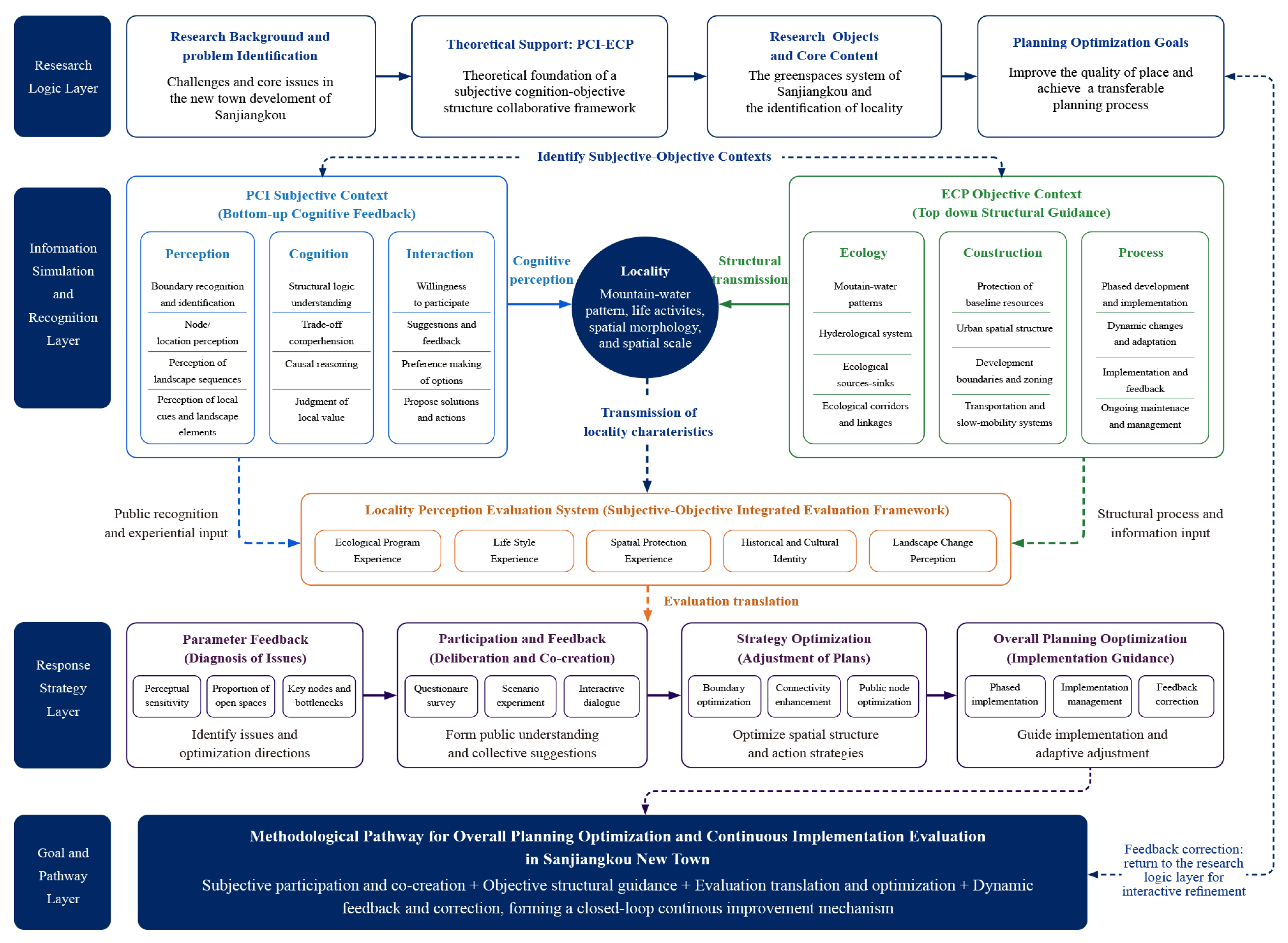
In this study, landscape-flow transformation is understood through three interrelated types of flow. The first is ecological flow, which refers to the movement and regulation of water, habitat, vegetation, energy, and ecological processes through the green-space network. The second is human activity flow, which refers to daily access, recreation, slow mobility, waterfront use, and public-space occupation. The third is temporal implementation flow, which refers to the staged construction, maintenance, feedback, and adjustment of the planning scheme. These three types of flow are not separated in practice. They jointly shape how the green-space network changes from an ecological substrate into an urban spatial structure and then into an adaptive planning program. On this basis, the coupled PCI–ECP analytical framework integrates subjective perception, cognition, and interaction with objective ecological, construction, and implementation-process dimensions, thereby forming a closed-loop pathway from information recognition to planning evaluation, strategy optimization, and implementation feedback, as illustrated in Figure 1.
Based on this typology, this paper defines landscape-flow transformation in urban green-space networks as the dynamic generation, systemic constraint, and feedback iteration of network morphology, functional connection, and temporal evolution under the continuous interaction of regional ecological substrates and human activities. Locality is not an external label of visual landscape character. It is an internal representation of landscape-flow transformation across regional ecology, everyday habitation, and spatial order.
PCI constitutes the subjective research dimension of the framework and forms a planning-communication chain of perception, cognition, and interaction. Perception is the public’s embodied experience of green-network boundaries, connectivity, node layout, temporal change, and locality cues in landscape-flow scenarios. Cognition is the public’s overall understanding of network structural logic, planning decisions, and implementation effects. Interaction is the planning feedback, optimization parameters, and negotiated participatory behavior that the public generate on the basis of perception and cognition.
ECP constitutes the objective research dimension and reveals the internal association between green-space networks and master planning through ecology, construction, and program. Ecology is rooted in the regional ecological substrate and answers why a green-space network emerges here. Construction focuses on how the network shapes urban space, transportation, and functional structures. Program addresses how the network continues to evolve and calibrate the master-planning scheme. Together, PCI and ECP form an integrated subject–object research system: PCI translates subjective public experience into implementable planning parameters, while ECP analyzes the generative mechanism of green-space networks and their effects on urban spatial structure.

2.5. Locality and Landscape-Flow Transformation in Urban Green-Space Networks

Introducing locality into landscape and urban green-space network research is necessary because locality should not be reduced to poetic symbols, stylistic elements, or historical imagery. It should be understood as the combined manifestation of ecological processes, ways of life, spatial order, historical culture, and transformation experience in a specific region. Existing studies on sense of place, place attachment, and environmental design indicate that perceived environmental attributes, urban regeneration, walkability, and place attachment can all shape how users evaluate urban and landscape settings [20,21,22]. Only when locality is translated into structural variables that can be identified, compared, and evaluated can green-space network research enter planning analysis and public communication.
This study operationalizes locality through five core dimensions: ecological process, way of life, spatial order, historical culture, and transformation experience. To avoid treating locality as a purely descriptive concept, Table 1 links the five locality dimensions to observable spatial indicators and planning parameters used in the Sanjiangkou evaluation.
While the first four dimensions establish stable benchmarks for identifying local spatial features, the fifth dimension reflects the dynamic nature of locality. Rather than remaining fixed, locality is perceived, interpreted, and restructured continuously during planning, construction, usage, and management practices. Within social–ecological systems, locality formation emerges from ongoing recognition and value assessment of unique spatial characteristics. Knaps et al. proposed meaningful places as an indicator of sense of place in social–ecological system management [23], while Polas et al. used spatial mapping in the Sundarbans Delta to show that landscape values and sense of place are coupled with livelihood, social activity, aesthetics, and cultural memory [24]. Landscape perception research in China similarly emphasizes the need to connect sensory experience, visual evaluation, and landscape meaning [25].
Locality not only explains why the landscape of a given area is distinctive. It also forms an internal basis for the generation, organization, and evolution of green-space networks. Hydrological connections, habitat patches, historical routes, and spatial textures provide boundary constraints, structural cues, and node bases for green-space networks. At the same time, local experience, everyday activities, and place identity enhance public understanding, use, and feedback. Locality therefore helps transform green-space networks from environmental land supplied after development into frontloaded structural systems that guide urban–rural master planning through dynamic relationships among ecological constraint, spatial growth, implementation feedback, and public negotiation.
Before entering the empirical analysis, it is necessary to clarify how locality and public participation are positioned in this study. Locality is not treated as a static landscape character to be reproduced in planning drawings, but as a generative mechanism shaped by ecological processes, everyday use, spatial order, historical culture, and transformation experience. Accordingly, public participation is not limited to reviewing completed planning images. It is expected to engage with structural logic, implementation sequence, and parameter trade-offs through scenario-based materials that can be perceived, compared, and fed back.

3. Materials and Methods

3.1. Case Area and Suitability: The Mountain–Water Pattern of Sanjiangkou New Town

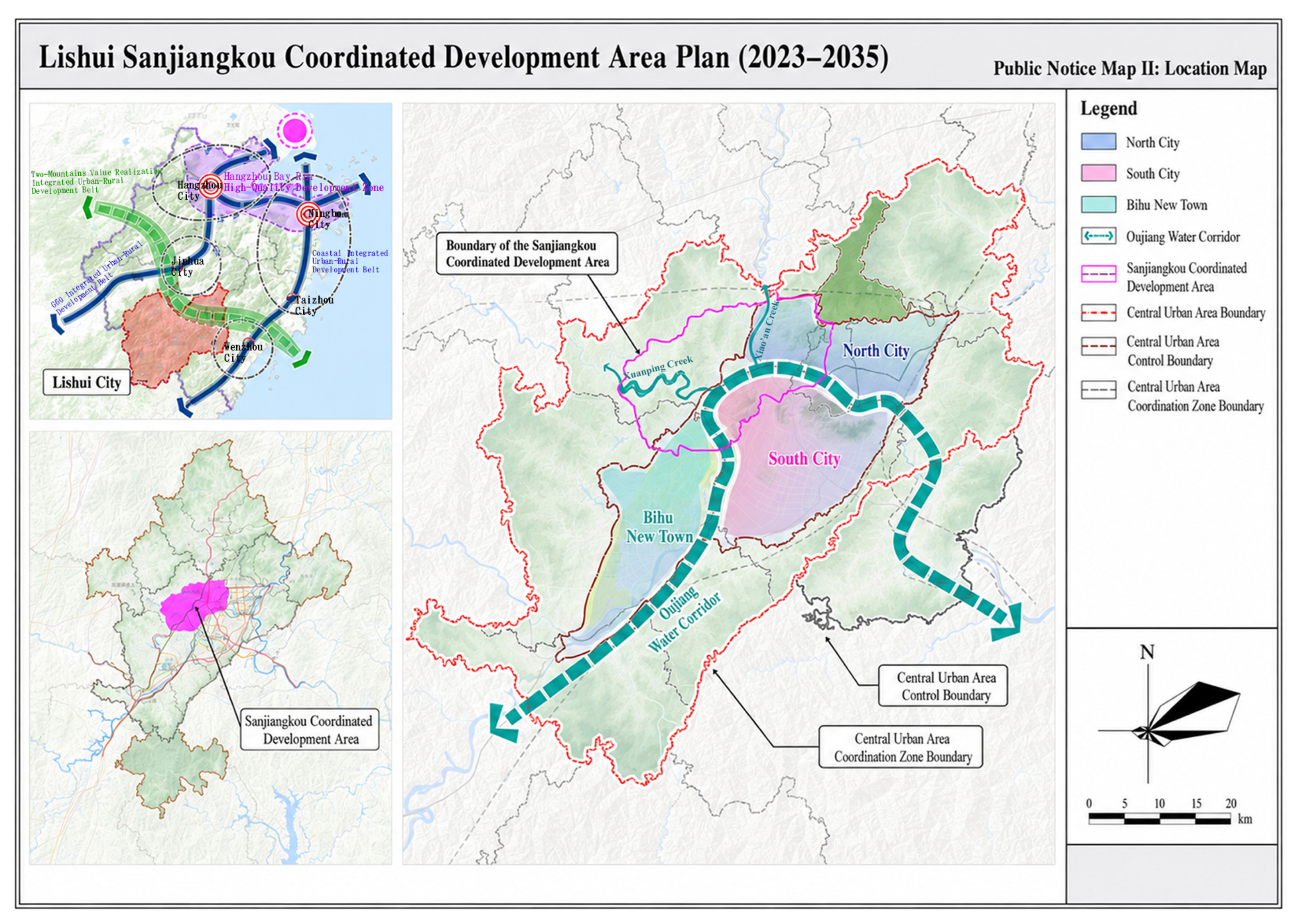
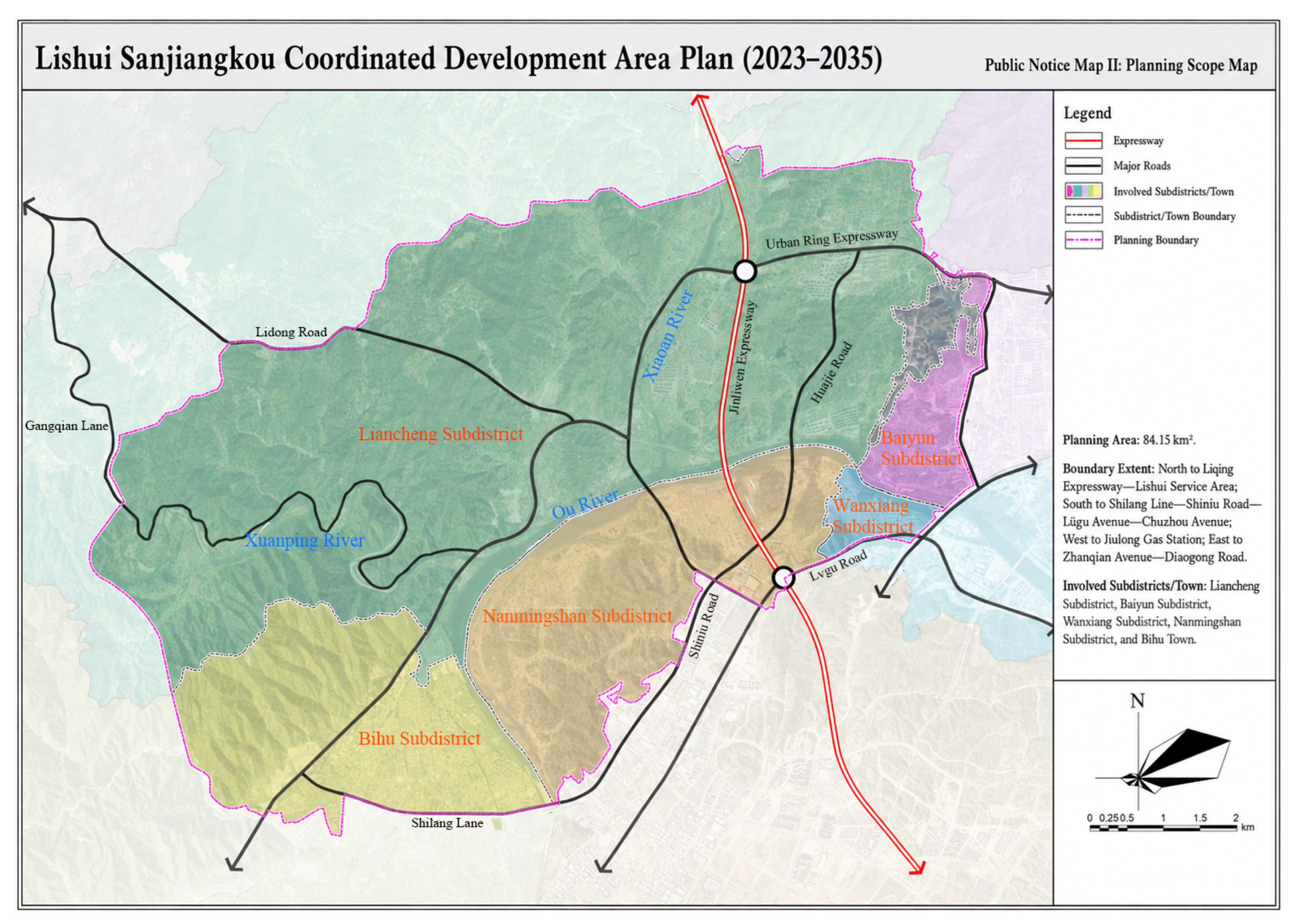
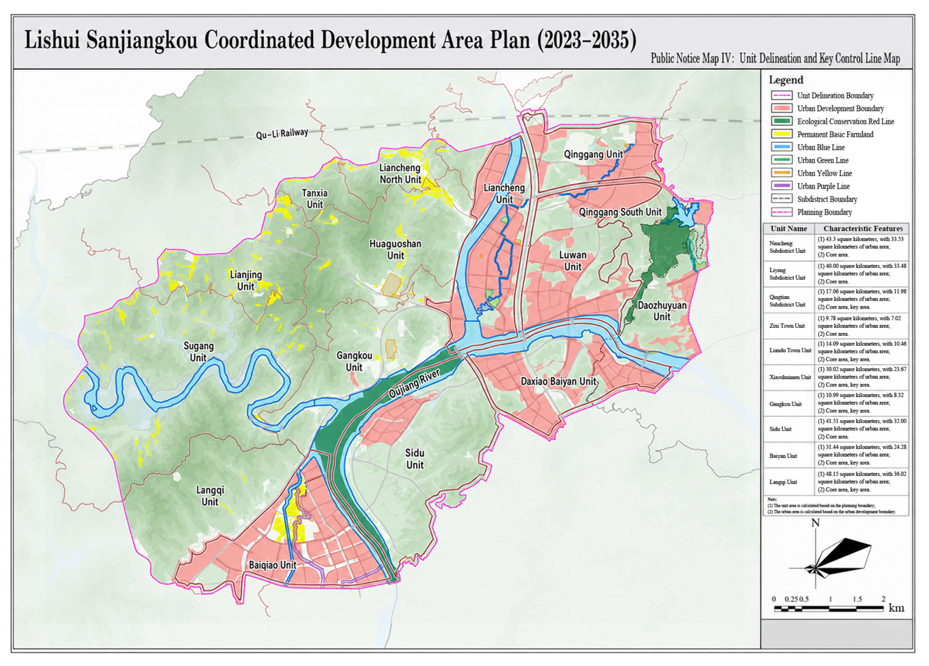
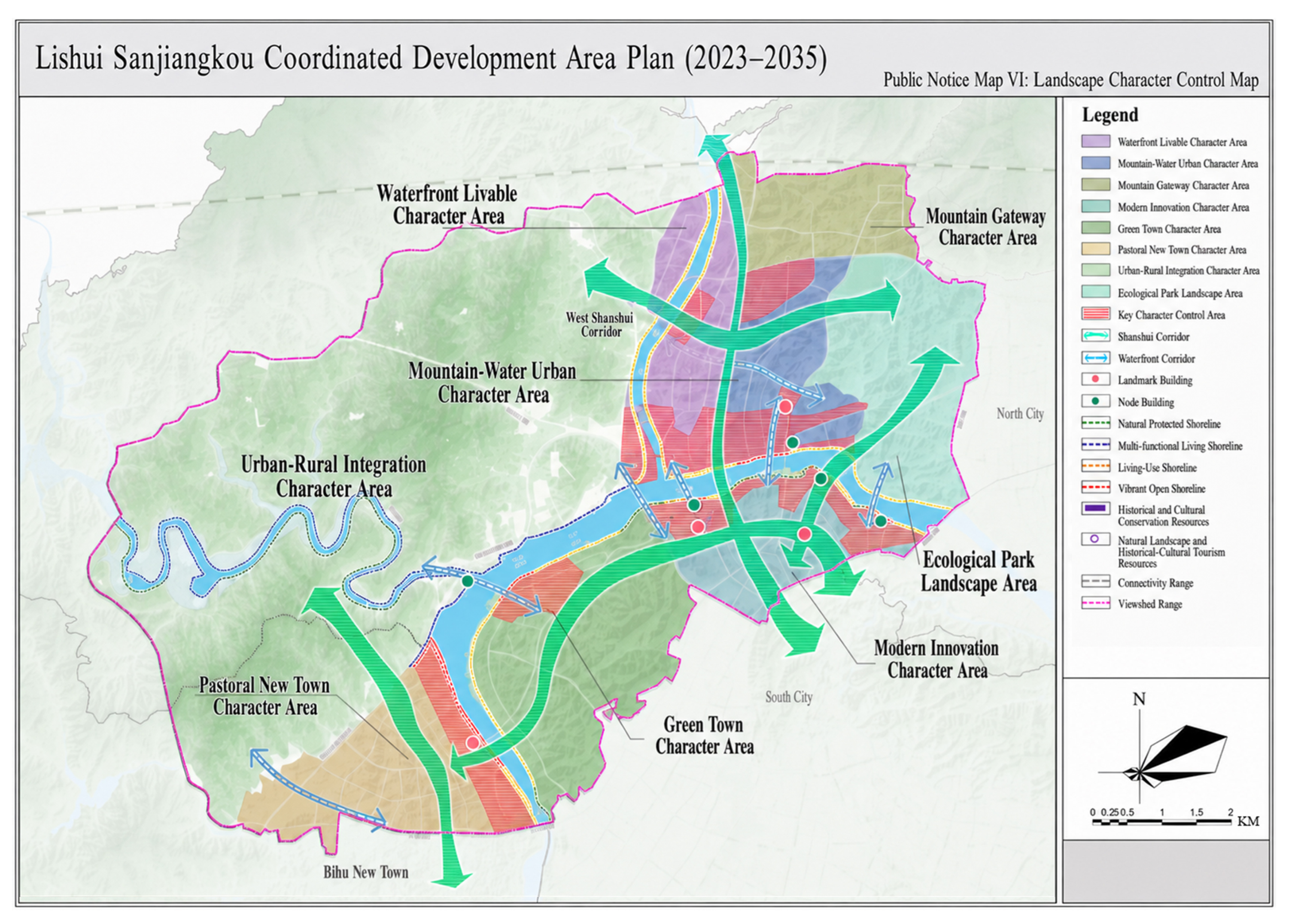
As shown in Figure 2, Sanjiangkou New Town is located at the intersection of North City, South City, and Bihu New Town in Liandu District, Lishui, Zhejiang Province, China. It is the confluence area of the Oujiang River, Xuanping Creek, and Xiao’an Creek, with a total area of approximately 84.15 km2. As a case, Sanjiangkou simultaneously involves ecological-risk management, spatial-structure organization, long-term construction sequencing, and public-perceivable locality expression. It is therefore suitable for testing the explanatory capacity of the PCI-ECP framework in relation to the formation of green-space networks, the distinction between basic and transformation patterns, and public participation responses. The planning boundary, planning units and key control lines, and landscape-character control are presented in Figure 3, Figure 4, and Figure 5, respectively.

3.2. Research Design

The research follows a three-layer procedure: case evidence-chain identification, subject–object translation, and participatory evaluation with feedback. The first layer identifies the objective environmental-field logic. Through planning-document and map interpretation, ecological-program and risk identification, spatial-structure inference, and phasing-strategy analysis, the study identifies the objective logic by which the Sanjiangkou green-space network develops from locality-based landscape ecology into substrate constraint, from network skeleton into spatial construction, and from implementation operation into dynamic feedback.
The second layer constructs subject–object translation. Boundaries, nodes, connectivity relationships, open interfaces, and stage changes that are closely related to public perception are translated from the objective ECP field into landscape-flow representation materials that participants can view, compare, and judge. These materials form the subjective scenarios that support public understanding.
The third layer conducts participatory evaluation and feedback writing. Using PCI as the subjective evaluation framework, the study obtains feedback on locality perception, structural understanding, and implementation trade-offs. The feedback is then translated into parameter evidence that can inform master-plan optimization, including corridor width, open-space proportion, crossing nodes, ecological-buffer scale, and phasing priority.

3.3. Scenario Construction and PCI Evaluation Design

3.3.1. Static-Transformation Comparative Scenarios

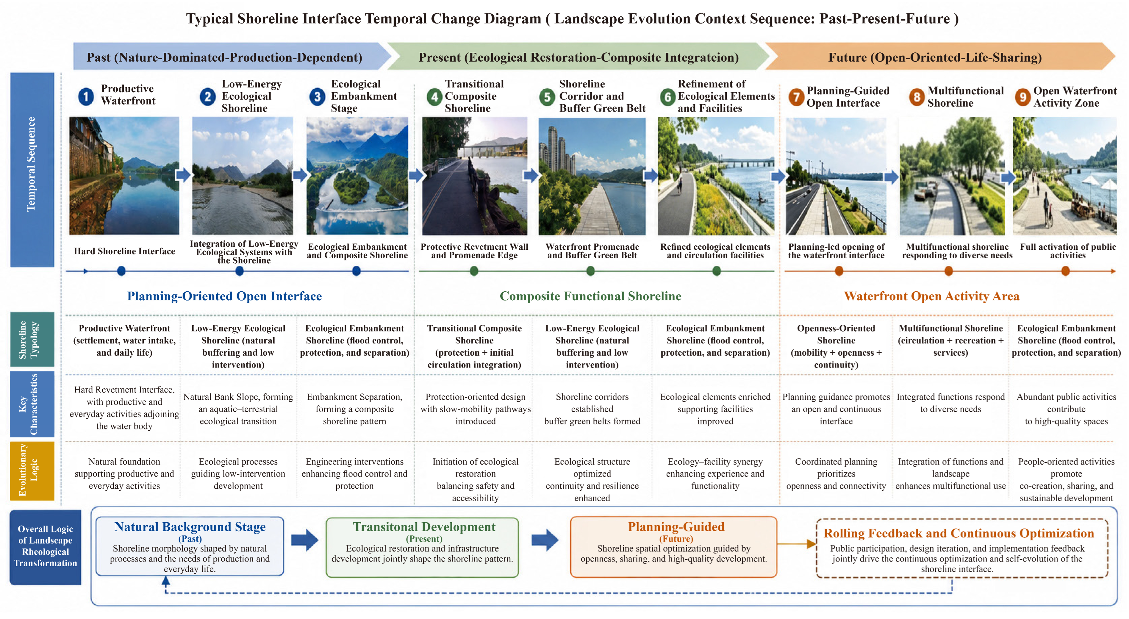
Figure 6 shows a representative set of the scenario materials used in the survey.
Using the key landscape spatial structures in the Sanjiangkou Master Plan as prototypes, three scenario sequences were constructed to directly couple PCI and ECP. The first was an ecology–construction sequence, including the changing boundaries and scales of floodplain space, wetland restoration belts, and ecological buffer corridors. This sequence presents how ecological substrate is translated into spatial-construction parameters. The second, a construction–program sequence, focused on the gradual formation of continuous waterfront public space and slow-mobility crossing points. It illustrated how early spatial decisions could shape both the timing of development and the accessibility of public space. The third sequence examined ecological change, tracing shifts in vegetation succession, degrees of openness, and maintenance practices at different stages. Rather than treating the ecological setting as fixed after construction, it showed how environmental conditions continue to influence subsequent operation and management. Static diagrams were combined with landscape-flow illustrations in each sequence, forming the visual material through which participants evaluated the relationship between people and the environment. The scenario images were prepared and adjusted using Adobe Photoshop 26.2 (Adobe Inc., San Jose, CA, USA).
To clarify the experimental control of the three scenario sequences, Table 2 specifies the main comparison variables, controlled variables, and visualization standards used in the questionnaire materials.
The complete questionnaire package, including the static diagrams, landscape-flow sequence illustrations, PCI evaluation items, ranking questions, and open-ended feedback prompts, is provided in Supplementary Material S1.

3.3.2. Questionnaire Distribution and Sample Characteristics

The questionnaire targeted potential users and stakeholder groups of Sanjiangkou, including residents around the new town, people studying or working in Lishui, and practitioners with planning, design, or management experience. A total of 462 questionnaires were collected. After excluding 18 responses without consent and 44 responses that failed the quality-control item, 400 valid questionnaires remained for analysis, corresponding to a valid response rate of 86.6%. The demographic characteristics of the valid respondents are summarized in Table 3.

3.3.3. Measurement Instruments and Variable Operationalization

Questionnaire items were developed in line with the PCI framework. At the perception stage, respondents were asked whether they could identify local cues, recognize areas undergoing spatial transformation, and distinguish the main elements presented in the scenarios. The cognition stage examined their understanding of the proposed spatial structure and implementation process, together with their ability to assess planning trade-offs. The interaction stage considered whether respondents were willing to participate and whether their comments were clear, directed toward specific issues, capable of being translated into planning actions, and open to further discussion. The survey also identified the planning parameters addressed by these comments, such as corridor width, the proportion of open space, crossing-node locations, ecological-buffer dimensions, and development priorities across different phases.

3.3.4. Experimental Procedure

The experiment proceeded in four stages. Participants first provided background information on their demographic characteristics, familiarity with the area, frequency of residence or visits, preferences for green space, and perceptions of risk. They then reviewed the scenario materials one sequence at a time, with brief attention checks administered after each sequence. Perception and cognition were measured immediately afterward using the P- and C-layer scales. In the final stage, interaction-related data were collected through ranking items, open-ended responses, and prompts inviting participants to comment on specific planning parameters.

3.3.5. Statistical Analysis and Model Testing

The data analysis included five steps. First, data screening was conducted by excluding responses without informed consent, responses that failed the attention-check item, and evidently invalid responses. Second, Harman’s single-factor test was applied to all Likert-type measurement items as a diagnostic check for possible common method variance. This test was used to assess whether the questionnaire responses were dominated by a single common factor. Third, reliability was examined using Cronbach’s alpha for the PCI measurement scales. Fourth, descriptive statistics and independent-samples t-tests were used to compare PCI evaluations between local and non-local respondents. Fifth, a simplified PCI path analysis with bootstrap mediation testing was conducted to examine whether cognition served as an intermediate link between perception and interaction. Data cleaning, descriptive statistics, reliability analysis, independent-samples t-tests, and exploratory PCI path and bootstrap mediation analyses were conducted using Python 3 (Python Software Foundation, Wilmington, DE, USA).

4. Results

4.1. PCI Evaluation Results for Landscape-Flow Scenarios

Data Screening and Common-Method Diagnostics

Of the 462 returned questionnaires, 400 were retained after excluding 18 responses without informed consent and 44 responses that failed the quality-control item, corresponding to a valid response rate of 86.6% (Table 4).
Harman’s single-factor test was conducted to diagnose possible common method variance. The test included 41 Likert-type measurement items from the valid questionnaires. The first unrotated factor explained 71.53% of the total variance, suggesting that common method variance could not be completely excluded. This result does not invalidate the dataset, but it indicates that the PCI pathway should be interpreted as exploratory evidence of association rather than as definitive causal proof. Procedural controls were adopted in the questionnaire design, including anonymous participation, informed consent, an attention-check item, and the exclusion of invalid responses.

4.2. Public Evaluation of Landscape-Flow Scenarios

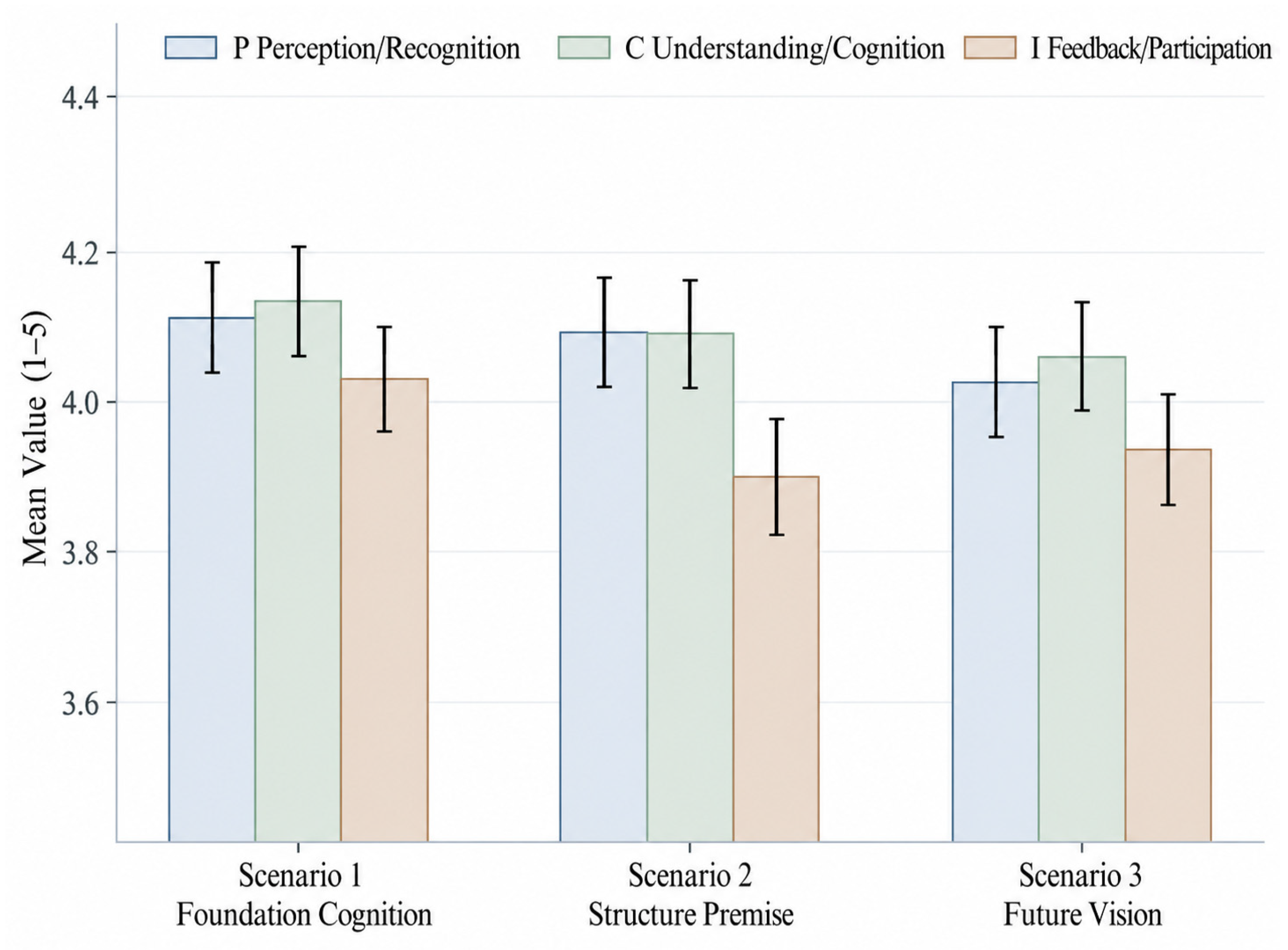
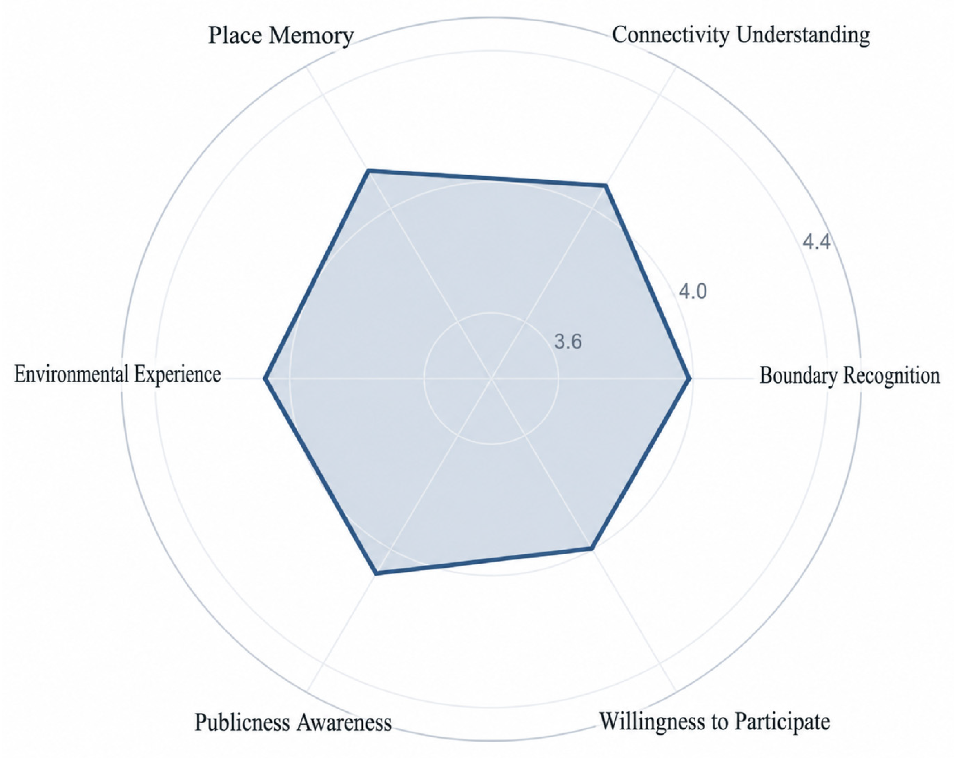
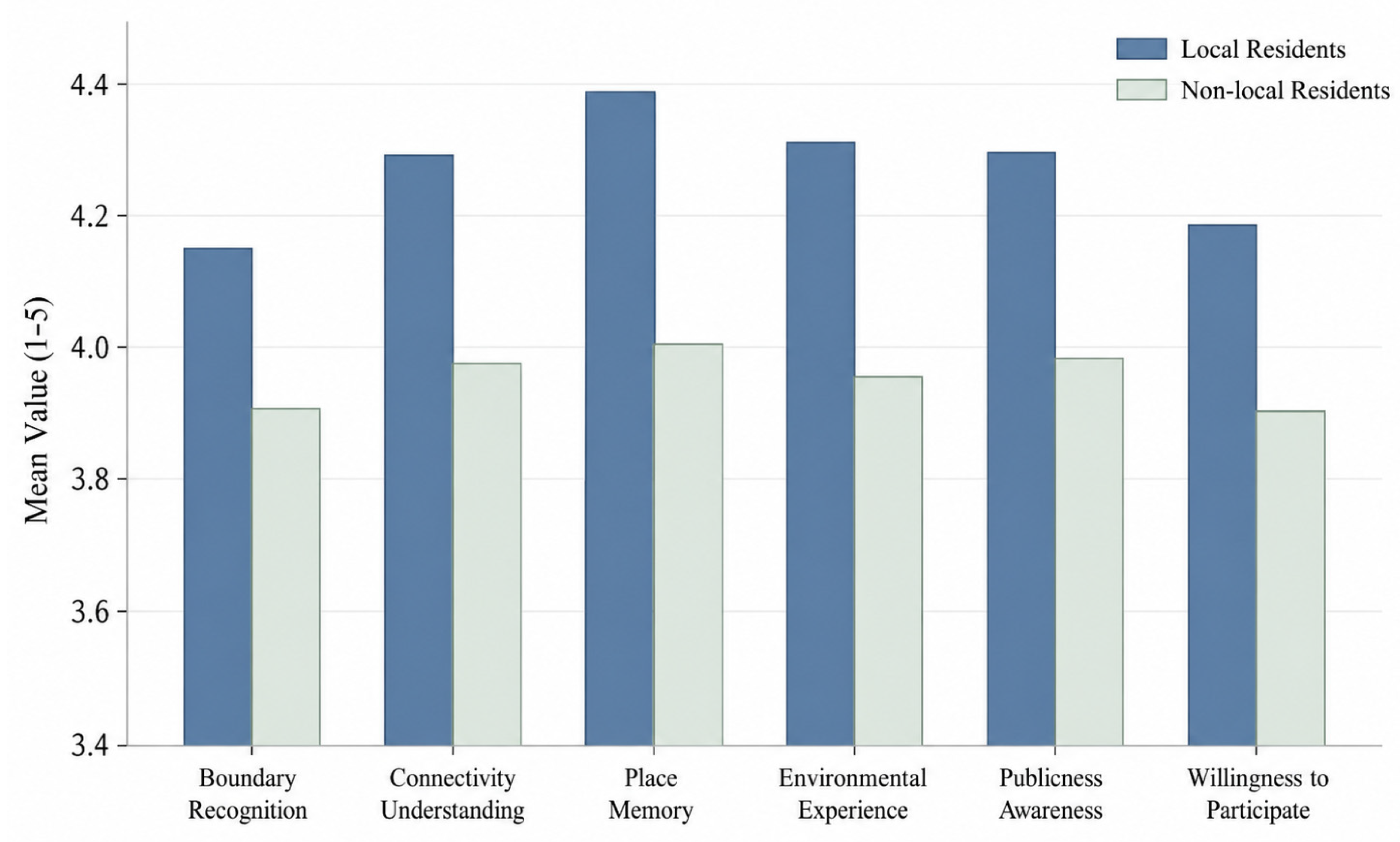
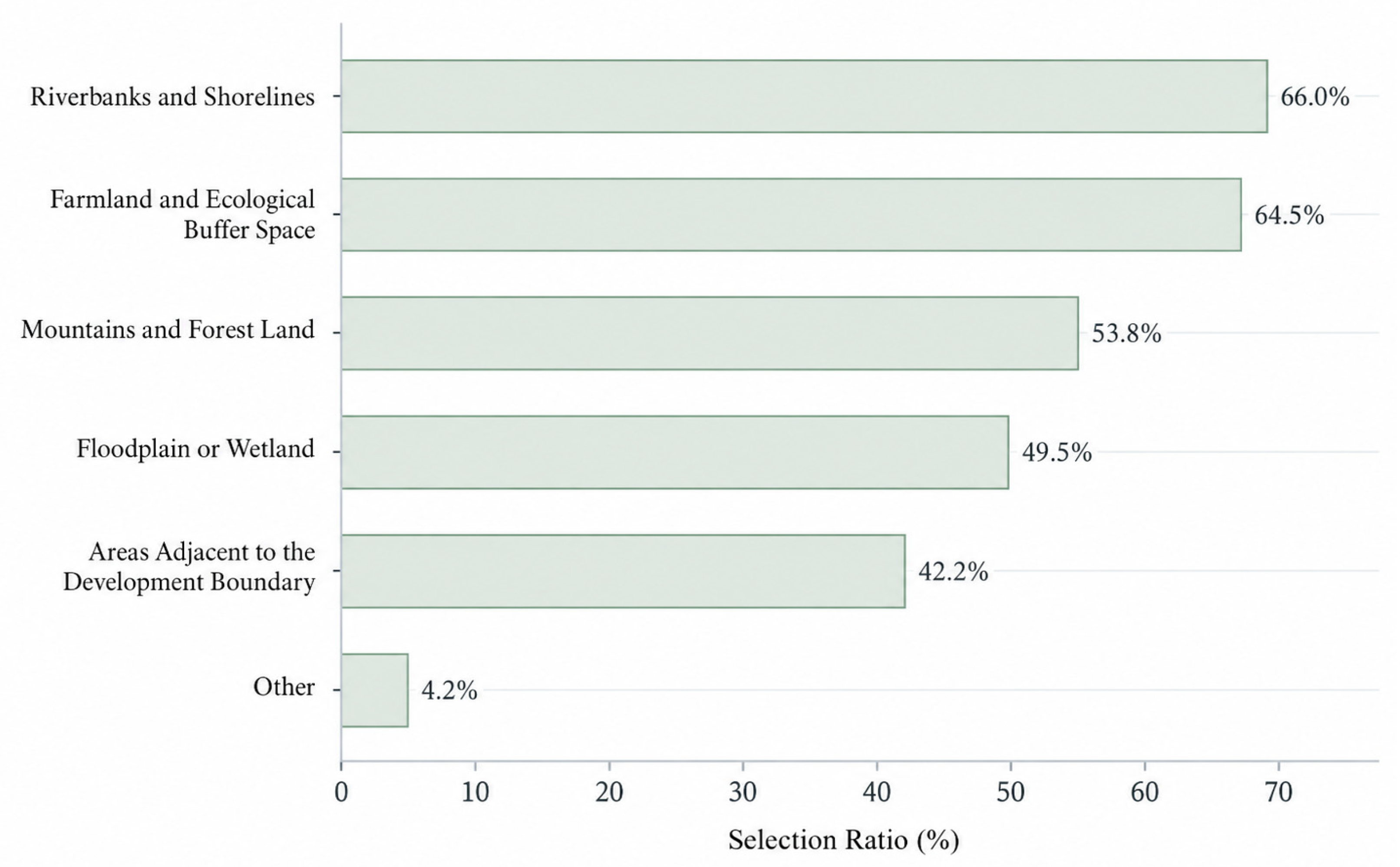
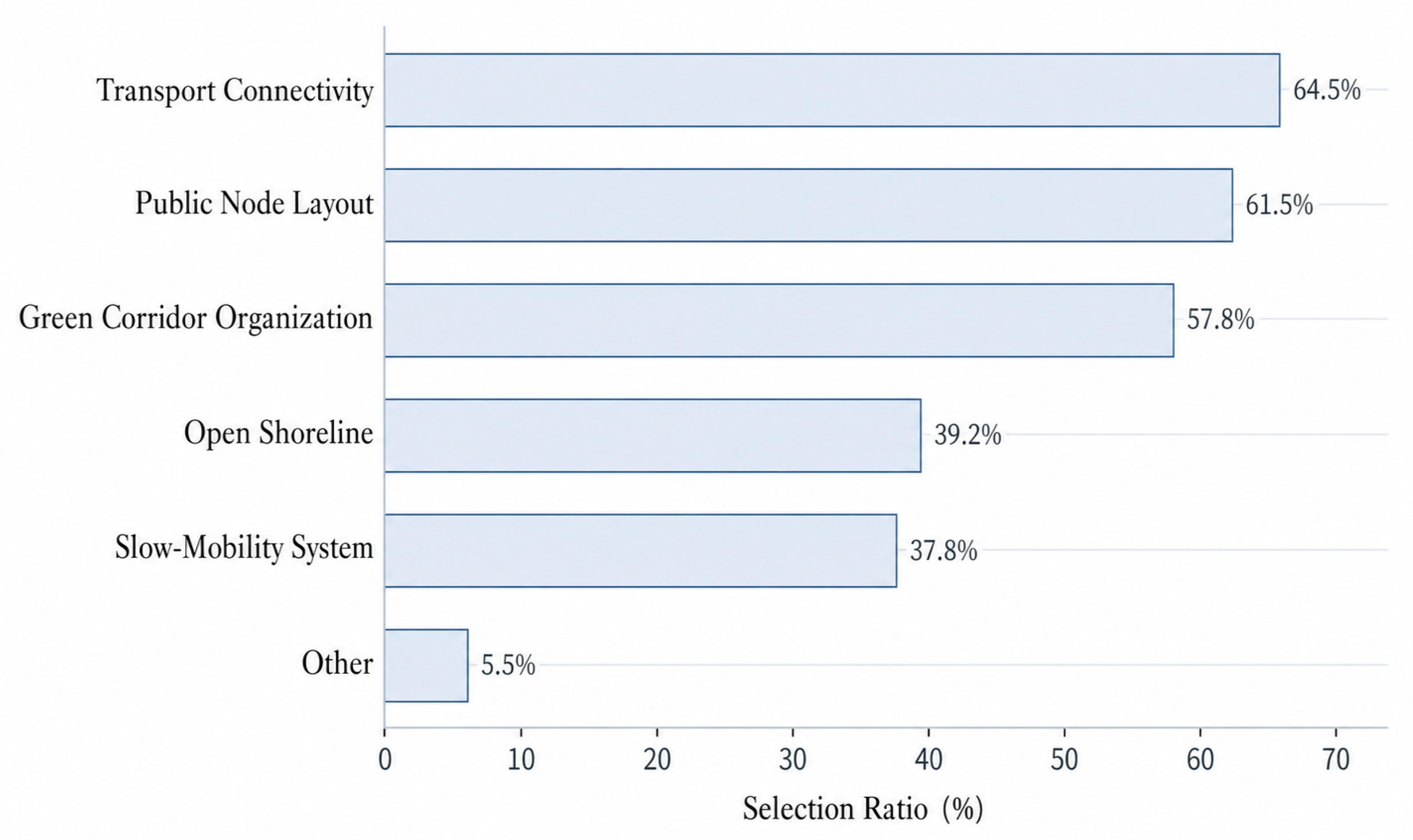
The scenario-sequence results show that, in the ecology–construction sequence, respondents most frequently selected riverbanks and shorelines (66%) and farmland and ecological buffer space (64.5%) as priority spaces, followed by mountains and forest land (53.8%), floodplains or wetlands (49.5%), and areas adjacent to the development boundary (42.2%). In the construction–program sequence, the highest selection ratios were observed for transport connectivity (64.5%), public nodes layout (61.5%), and green-corridor organization (57.8%). These results suggest that respondents were not only responding to abstract planning concepts, but were also identifying spatial objects directly related to daily access, stay, and use. The mean PCI scores across the three sequences are shown in Figure 7, while the six-dimensional locality evaluation and local–non-local differences are presented in Figure 8 and Figure 9. The corresponding priority-space selections, optimization preferences, and overall evaluation are reported in Figure 10, Figure 11 and Figure 12.
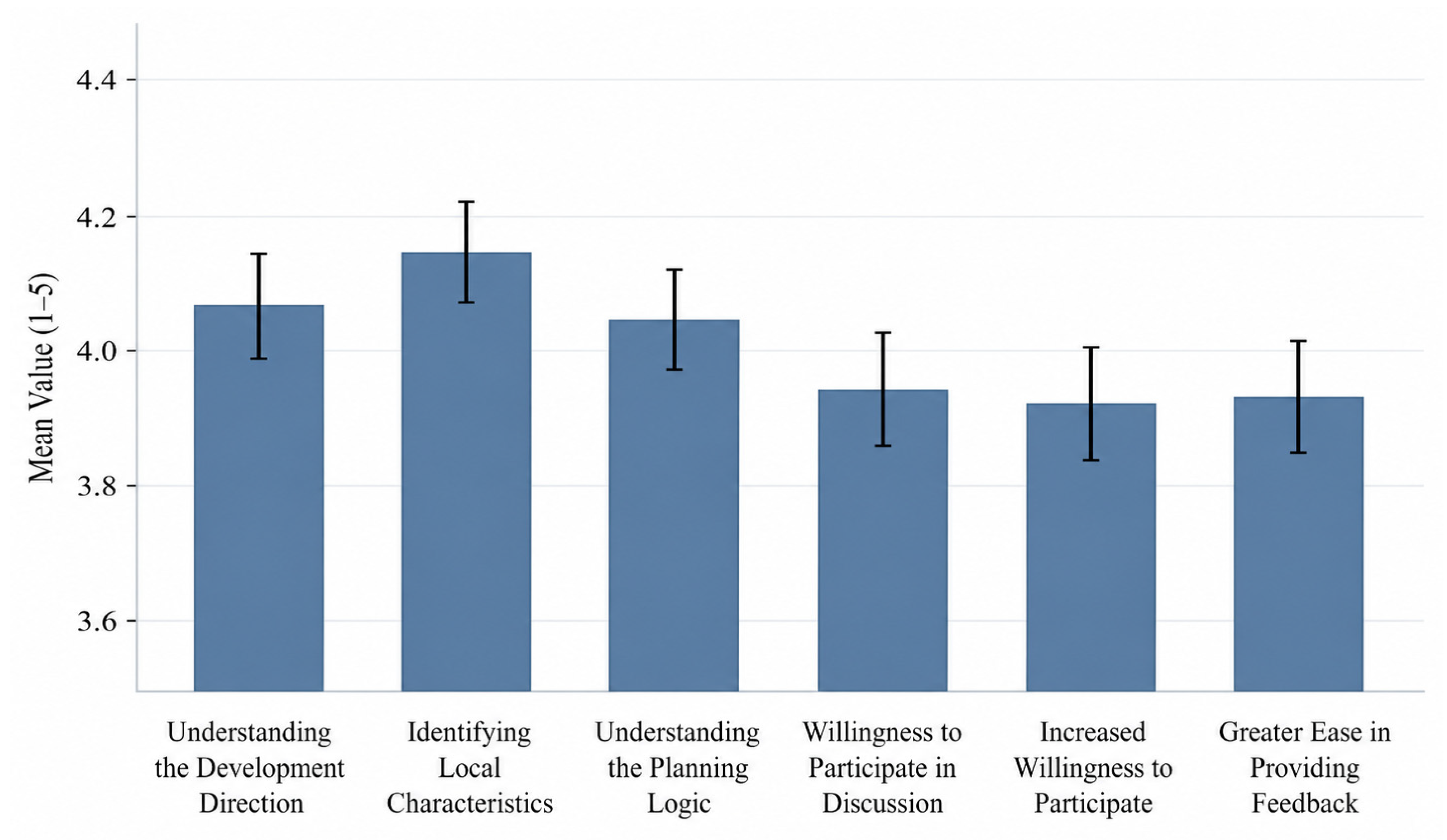
The overall evaluation further indicates that the scenario package performed well in helping respondents understand future construction directions, identify mountain–water locality characteristics, and understand planning logic. Independent-samples t-tests showed that local residents scored higher than non-local respondents on the P composite (4.268 vs. 3.981, p < 0.001), C composite (4.312 vs. 3.986, p < 0.001), and I composite (4.100 vs. 3.889, p = 0.004). These differences suggest that local living experience may strengthen recognition, understanding, and feedback capacity in relation to planning scenarios. Given the common-method diagnostic result reported above, these findings should be read as statistically supported associations within this dataset rather than as conclusive evidence of causality. The reliability results are summarized in Table 5, and the simplified PCI path and bootstrap mediation results are reported in Table 6.
The simplified PCI path analysis showed a strong positive association between perception and cognition. When perception and cognition were entered together to predict interaction, cognition remained positively associated with interaction after controlling for perception, while perception also retained a significant direct association with interaction after controlling for cognition. The bootstrap mediation test further indicated a significant indirect association from perception to interaction through cognition. These findings support the internal consistency of the PCI chain as an exploratory interpretive model, but they should not be read as definitive causal evidence because common method variance cannot be fully excluded.

4.3. Locality-Based Landscape Ecology as the Green-Space Network Substrate

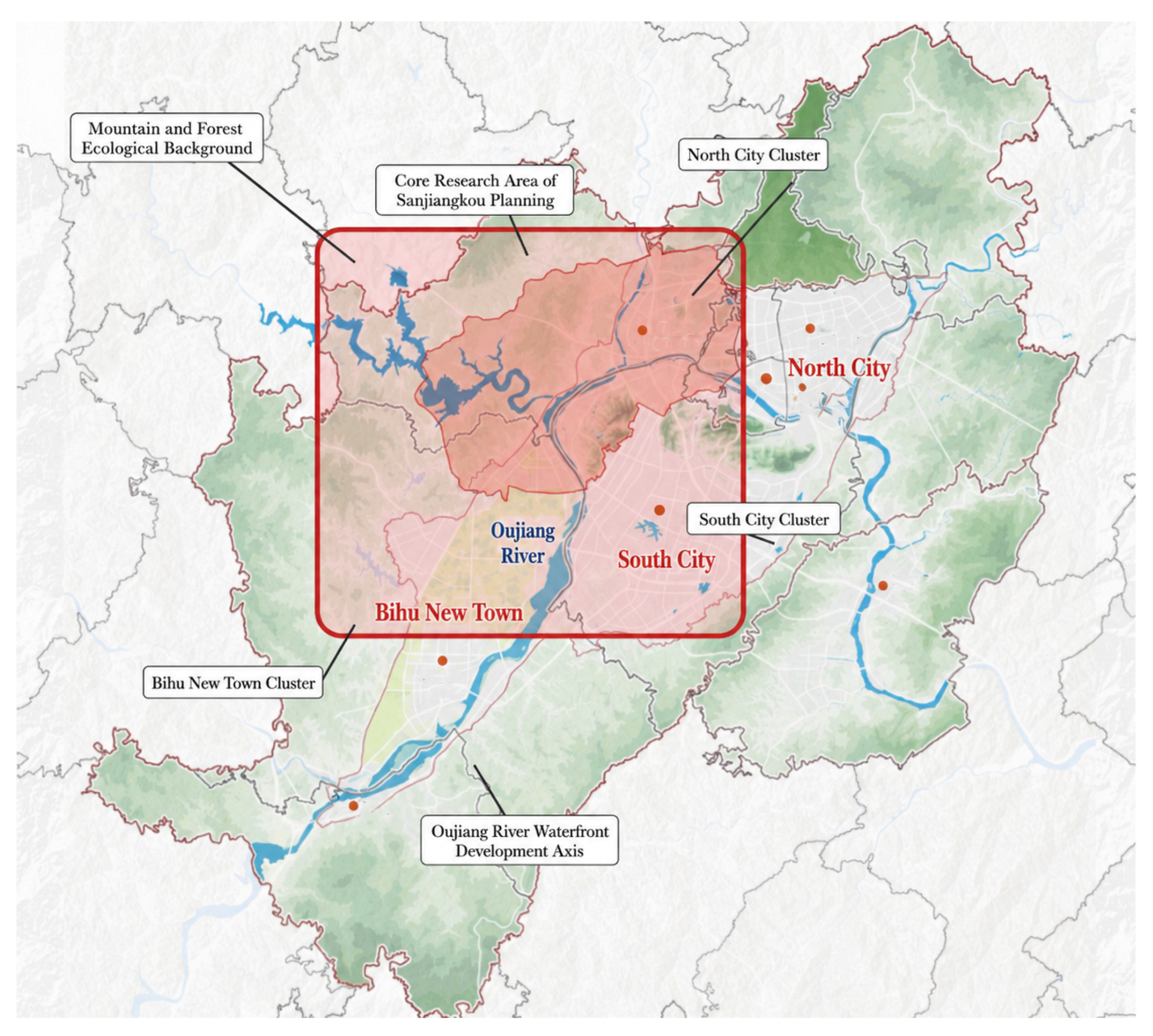
Sanjiangkou New Town’s urban green network originates from local hydrological regimes, topographic features, vegetation evolution, and residential living patterns. The main rivers and tributary systems steer ecological operation trends, waterfront boundary layouts, and urban expansion orientations. Floodplain terrains and dike-side elevation differences support flood regulation, water storage, and ecological buffering, establishing fundamental spatial constraints for urban construction. Riparian mountain woodlands act as stable ecological sources and landscape backdrops, shaping corridor layouts, green wedge distribution, and visual spatial structures. Riverside settlements, traditional ferry passages, and historic daily trails collectively endow core waterfront nodes with high accessibility, public vitality, and open spatial attributes. From the perspective of landscape-flow transformation, they continue to influence adjustments to spatial structure through phased construction, opening for use, and maintenance feedback. These relationships are illustrated in Figure 13.

4.4. Frontloaded Effects of the Urban Green-Space Network on Urban Spatial Structure

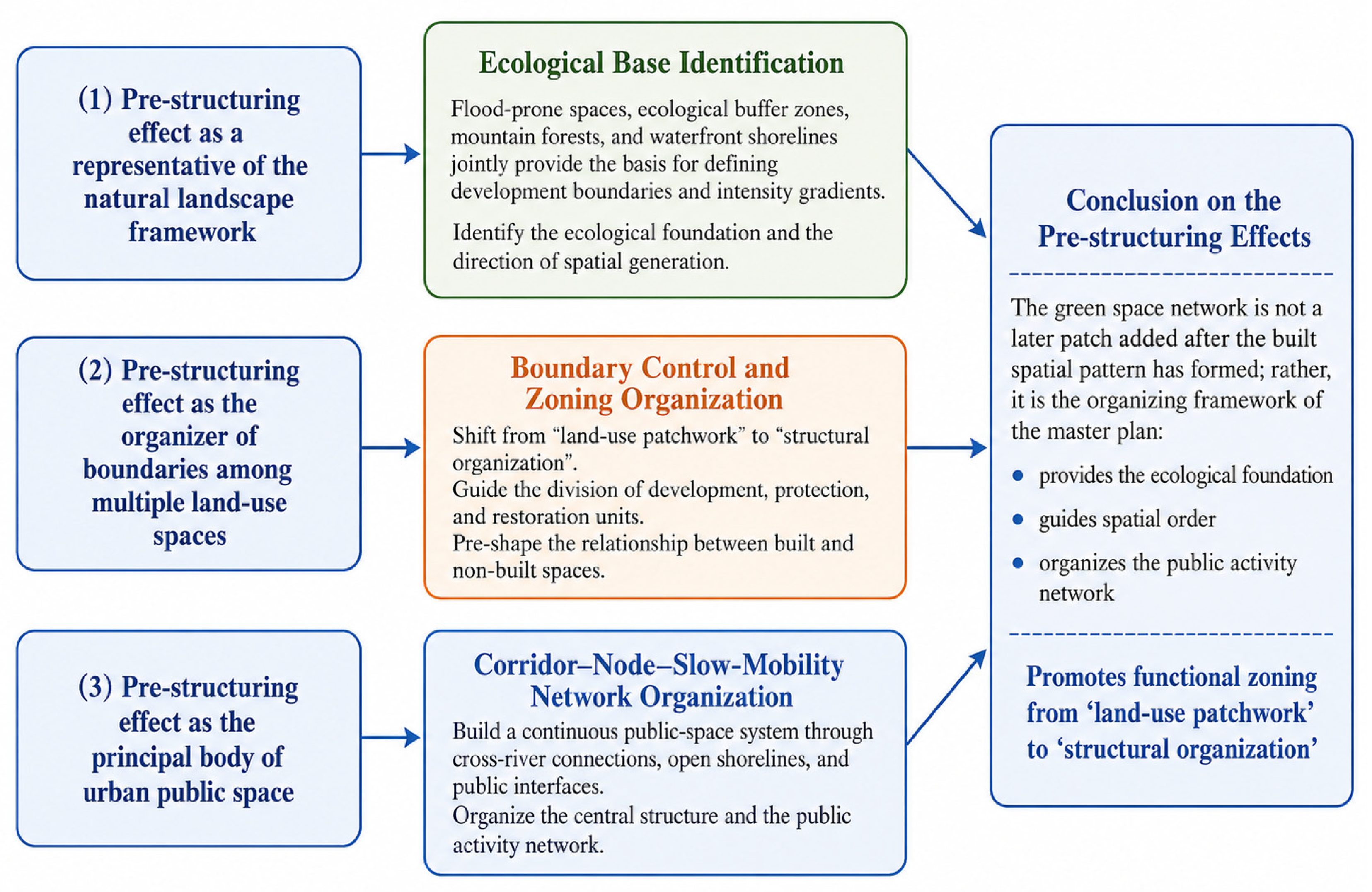
The frontloaded effect of urban green-space networks on spatial structure is not simply ecological reservation in the sense of a single indicator. It is manifested through three interrelated roles: representing the natural mountain–water pattern, governing the boundaries of multiple land uses, and organizing the main public-space system. The core issue is how the green-space network becomes a leading skeleton for organizing spatial structure, controlling development intensity, and guiding public activities at the front end of planning. The corresponding frontloading mechanism is summarized in Figure 14.
First, the Sanjiangkou green-space network is a spatial representation of the regional mountain–water pattern. Rivers, floodplains, mountains, and shorelines jointly constitute the ecological matrix of new-town development. Forward-looking green-space planning converts inherent natural substrates into standardized planning structures. It takes floodplain spaces, ecological buffer belts, and landscape corridors as core bases for defining construction boundaries, controlling development intensity, and arranging visual corridors. In this way, the green network structurally embodies natural features and translates ecological constraints into tangible planning guidelines.
Furthermore, the green-space network coordinates the spatial layout of residential, industrial, public service, and ecological conservation lands through boundary regulation and unified planning unit management. Instead of mechanically delimiting simple green boundaries, this method adopts ecological security standards, connectivity demands, and open spatial interfaces to categorize land units for development, protection, and ecological restoration. This approach reorganizes scattered land-use patterns into systematic spatial structures, turning green networks from passive supporting facilities into dominant spatial ordering principles for diverse land uses.
In terms of public spatial system construction, the green network establishes the primary urban public space framework by organizing ecological corridors, spatial nodes, and slow-traffic connections. Open waterfront interfaces, waterfront slow-mobility connections, cross-river nodes, and public stay spaces are not passively inserted after roads and land uses are determined. They are constructed simultaneously through the frontloaded introduction of the green-space network. As a result, the continuity, accessibility, and activity potential of public space can be organized at the master-planning stage. The questionnaire results further show that respondents evaluated boundary recognition, connectivity understanding, and willingness to participate relatively highly, while local memory, environmental experience, and publicness cognition still require improvement. This demonstrates that green-space-network frontloading is not only a technical logic but also a planning logic that must be perceived and understood through human–environment representation.

4.5. Shaping Prospective Planning Visions Through Green-Space Networks

For Sanjiangkou New Town, rivers, floodplains, mountains, shorelines, and historical settlement paths constitute the basic support for the future development vision. The new town’s spatial direction is therefore not a generic model imposed on an abstract site. It is formed on the basis of local ecological substrates and living logics. The green-space network can shape the future vision because landscape-flow representation transforms abstract targets into spatial scenarios that the public can perceive, understand, and interact with. Respondents can recognize changes in boundaries, corridors, nodes, and waterfront openness, further understand relationships among locality patterns, spatial organization, and implementation trade-offs, and then formulate feedback on open-space proportion, node priority, and slow-mobility continuity.

4.6. Dynamic Process Feedback and Master-Plan Calibration

Technical frontloading alone is insufficient to ensure that ecological and locality-oriented principles are maintained during the implementation of a master plan. Parameters such as corridor width, shoreline openness, crossing-node location, and phasing priority are directly linked to departmental coordination, development tempo, and public-interest distribution. They must therefore be transformed into objects that can be discussed, fed back, and modified. Subjective landscape-flow scenarios and the PCI framework can convert green-space networks from technical layers into planning languages that the public can perceive, understand, and interact with. This dynamic feedback helps calibrate the master-planning scheme in the long term.

5. Discussion

5.1. Contributions to Green-Infrastructure and Green-Space Network Planning

A main contribution of this study is to extend discussions of network connectivity and multifunctionality from green-infrastructure benefits to the generation and evolution of master planning. Existing studies often discuss functional benefits, spatial connectivity, or governance coordination. The Sanjiangkou case shows that multifunctionality is less likely to be diluted by single-purpose development logic when green-space networks enter development boundaries, spatial zoning, public-space organization, and phasing strategies from the beginning, and when they are understood as transformation patterns that continue to change through construction, use, and maintenance.

5.2. Implications for Locality Research and Participatory Planning

The empirical findings return to the theoretical position introduced earlier: locality operates as a generative mechanism rather than as a static visual character. The PCI evaluation shows that scenario-based materials can help respondents move from recognizing spatial elements to understanding structural relationships and expressing planning feedback. From the human–environment perspective, public participation therefore becomes a process of judging and negotiating the operational mechanisms of locality, rather than merely reviewing planning drawings.

5.3. Comparison with Existing Studies

The findings of this study are broadly consistent with recent research that treats green infrastructure as more than ecological land or amenity space. Existing studies have emphasized connectivity, multifunctionality, governance, resilience, equity, stakeholder engagement, and long-term maintenance in green-infrastructure and nature-based-solution planning [1,2,3,4,26,27,28]. However, they pay less attention to how green-space networks can be translated into scenario materials that support public perception and feedback. The Sanjiangkou case responds to this gap by showing how a green-space network can enter master planning before construction–land boundaries, mobility structures, and functional zoning are fully fixed. It also echoes studies on participatory scenario evaluation and planning visualization [7,10], as well as recent discussions on local definitions of nature and community values in planning practice [29,30]. In this sense, the PCI–ECP framework connects objective green-space network formation with subjective public understanding.

5.4. Limitations and Future Research

The PCI-ECP framework and landscape-flow scenario design are most applicable to watershed new towns, waterfront districts, and urban expansion areas where hydrological constraints, ecological buffers, staged construction, and public-space accessibility need to be coordinated. This is consistent with recent blue–green infrastructure and peri-urban flood-risk studies, which emphasize the combined effects of climate hazards, land-use uncertainty, accessibility, and intervention timing in resilient spatial planning [31,32]. These contexts usually involve strong interactions among ecological processes, development boundaries, green-space networks, and phased implementation. The PCI component has broader transferability because it concerns how the public perceives, understands, and responds to planning scenarios. By contrast, the ECP indicators need to be recalibrated when the framework is applied to plain cities, dense built-up renewal areas, dryland systems, or contexts with weaker hydrological constraints.
This study has several limitations. First, it is based on a single case of Sanjiangkou New Town, and the applicability of the framework requires further testing through cross-case comparison. Second, the perceptual, cognitive, and interactional variables were collected through the same questionnaire; therefore, common method variance cannot be fully excluded. Although anonymous participation, an attention-check item, invalid-response exclusion, group comparisons, and bootstrap path testing were used to strengthen the analysis, the PCI pathway should still be understood as exploratory evidence of association rather than as definitive causal proof. Future research should combine questionnaires with interviews, behavioral observation, spatial-use records, and longitudinal participation data to further test the framework across different landform and hydrological systems.

6. Conclusions

Taking the official comprehensive master plan of Sanjiangkou New Town as a practical research case, the interconnected green infrastructure network of this three-river junction region originates from four core natural and cultural carriers: regional hydrological circulation systems, riparian floodplain zones, mountain forest patches, and historic daily living corridors. If this green network is designated as the core spatial skeleton at the initial planning stage, it will restructure the overall urban layout by defining buildable boundary limits, dividing functional spatial zones, arranging transit routes, distributing public open spaces, and setting staged development schedules. After the planning scheme enters construction and daily operation phases, continuous iterative adjustment will be carried out based on real-world operational feedback, ultimately shaping a circulating transformation system linking landscape morphology and material flow.
From a theoretical perspective, this study makes three main theoretical contributions. First, it reframes locality from a visual or cultural label into a generative mechanism of green-space network formation. Locality is therefore not only expressed through landscape character, but is also produced through ecological processes, everyday use, spatial order, historical traces, and transformation experience. Second, the study advances the understanding of urban green-space networks from post hoc environmental land-use allocation to frontloaded spatial structures in master planning. The Sanjiangkou case shows that green-space networks can influence development boundaries, functional zoning, mobility organization, public-space distribution, and phasing strategies at the beginning of the planning process. Third, the study proposes the PCI–ECP framework as a subject–object analytical approach that links public perception, planning cognition, and interactive feedback with ecological substrates, construction organization, and implementation programs. This framework helps explain how objective landscape-flow transformation can be translated into planning scenarios that the public can perceive, understand, and discuss.

Supplementary Materials

The following supporting information can be downloaded at https://www.mdpi.com/article/10.3390/buildings16142844/s1: Supplementary Material S1: Questionnaire and Scenario Materials.

Author Contributions

Conceptualization, B.L. and K.L.; methodology, K.L.; formal analysis, K.L.; investigation, K.L.; resources, B.L.; data curation, K.L.; writing—original draft preparation, K.L.; writing—review and editing, B.L. and K.L.; visualization, K.L.; supervision, B.L.; project administration, B.L.; funding acquisition, B.L. All authors have read and agreed to the published version of the manuscript.

Funding

This research was funded by the National Natural Science Foundation of China (NSFC), grant number 52130804.

Institutional Review Board Statement

Ethical review and approval were waived for this study because the questionnaire survey was anonymous, non-interventional, and involved no collection of personally identifiable or sensitive personal information. All respondents were informed of the research purpose before completing the questionnaire.

Informed Consent Statement

Written informed consent was waived because no personally identifiable information was collected. Implied informed consent was obtained from all participants through their voluntary completion of the anonymous questionnaire.

Data Availability Statement

The questionnaire materials are provided in Supplementary Material S1. The anonymized survey dataset is available from the corresponding author upon reasonable request, subject to privacy and research-use restrictions.

Acknowledgments

The authors gratefully acknowledge the support from Tongji University during the completion of this research.

Conflicts of Interest

The authors declare no conflicts of interest.

References

  1. Korkou, M.; Tarigan, A.K.M.; Hanslin, H.M. The multifunctionality concept in urban green infrastructure planning: A systematic literature review. Urban For. Urban Green. 2023, 85, 127975. [Google Scholar] [CrossRef]
  2. Vilanova, C.; Sardà Ferran, J.; Concepción, E.D. Integrating landscape ecology in urban green infrastructure planning: A multi-scale approach for sustainable development. Urban For. Urban Green. 2024, 94, 128248. [Google Scholar] [CrossRef]
  3. Grabowski, Z.J.; McPhearson, T.; Pickett, S.T.A. Transforming US urban green infrastructure planning to address equity. Landsc. Urban Plan. 2023, 229, 104591. [Google Scholar] [CrossRef]
  4. Slobodníková, K.; Tóth, A. Planning for people with people: Green infrastructure and nature-based solutions in participatory land-use planning, co-design, and co-governance of green and open spaces. Land 2025, 14, 1801. [Google Scholar] [CrossRef]
  5. Lindquist, M.; Campbell-Arvai, V. Co-designing vacant lots using interactive 3D visualizations: Development and application of the Land.Info DSS. Landsc. Urban Plan. 2021, 210, 104082. [Google Scholar] [CrossRef]
  6. Zellner, M.L. Participatory modeling for collaborative landscape and environmental planning: From potential to realization. Landsc. Urban Plan. 2024, 247, 105063. [Google Scholar] [CrossRef]
  7. Sahraoui, Y.; de Godoy Leski, C.; Benot, M.-L.; Revers, F.; Salles, D.; van Halder, I.; Barneix, M.; Carassou, L. Integrating ecological networks modelling in a participatory approach for assessing impacts of planning scenarios on landscape connectivity. Landsc. Urban Plan. 2021, 209, 104039. [Google Scholar] [CrossRef]
  8. Arnstein, S.R. A ladder of citizen participation. J. Am. Inst. Plan. 1969, 35, 216–224. [Google Scholar] [CrossRef]
  9. Campbell-Arvai, V.; Lindquist, M. From the ground up: Using structured community engagement to identify objectives for urban green infrastructure planning. Urban For. Urban Green. 2021, 59, 127013. [Google Scholar] [CrossRef]
  10. Eilola, S.; Jaalama, K.; Kangassalo, P.; Nummi, P.; Staffans, A.; Fagerholm, N. 3D visualisations for communicative urban and landscape planning: What systematic mapping of academic literature can tell us of their potential? Landsc. Urban Plan. 2023, 234, 104716. [Google Scholar] [CrossRef]
  11. Wang, Y.; Lin, Y.-S. Public participation in urban design with augmented reality technology based on indicator evaluation. Front. Virtual Real. 2023, 4, 1071355. [Google Scholar] [CrossRef]
  12. Foroughi, M.; Andrade, B.; Pereira Roders, A.; Wang, T. Public participation and consensus-building in urban planning from the lens of heritage planning: A systematic literature review. Cities 2023, 135, 104235. [Google Scholar] [CrossRef]
  13. Nasr-Azadani, E.; Wardrop, D.; Brooks, R. Is the rapid development of visualization techniques enhancing the quality of public participation in natural resource policy and management? A systematic review. Landsc. Urban Plan. 2022, 228, 104586. [Google Scholar] [CrossRef]
  14. Wang, D.; Xu, P.-Y.; An, B.-W.; Guo, Q.-P. Urban green infrastructure: Bridging biodiversity conservation and sustainable urban development through adaptive management approach. Front. Ecol. Evol. 2024, 12, 1440477. [Google Scholar] [CrossRef]
  15. Kirk, H.; Soanes, K.; Amati, M.; Bekessy, S.; Harrison, L.; Parris, K.; Ramalho, C.; van de Ree, R.; Threlfall, C. Ecological connectivity as a planning tool for the conservation of wildlife in cities. MethodsX 2023, 10, 101989. [Google Scholar] [CrossRef] [PubMed]
  16. Cook, L.M.; Good, K.D.; Moretti, M.; Kremer, P.; Wadzuk, B.; Traver, R.; Smith, V. Towards the intentional multifunctionality of urban green infrastructure: A paradox of choice? npj Urban Sustain. 2024, 4, 12. [Google Scholar] [CrossRef]
  17. Perera, A.C.S.; Davies, P.J.; Graham, P.L. A global review of urban blue-green planning tools. Land Use Policy 2024, 143, 107093. [Google Scholar] [CrossRef]
  18. Vaňo, S.; Olafsson, A.S.; Mederly, P. Advancing urban green infrastructure through participatory integrated planning: A case from Slovakia. Urban For. Urban Green. 2021, 58, 126957. [Google Scholar] [CrossRef]
  19. Moon, T.; Kim, M.; Chon, J. Adaptive green space management strategies for sustainable carbon sink parks. Urban For. Urban Green. 2024, 94, 128236. [Google Scholar] [CrossRef]
  20. Escolà-Gascón, Á.; Riascos, A.; Gallifa, J.; Houran, J. Evidence of environmental urban design parameters that increase and reduce sense of place in Barcelona (Spain). Landsc. Urban Plan. 2023, 235, 104740. [Google Scholar] [CrossRef]
  21. Falanga, R. Understanding place attachment through the lens of urban regeneration: Insights from Lisbon. Cities 2022, 122, 103590. [Google Scholar] [CrossRef]
  22. Koohsari, M.J.; Yasunaga, A.; Oka, K.; Nakaya, T.; Nagai, Y.; McCormack, G.R. Place attachment and walking behaviour: Mediation by perceived neighbourhood walkability. Landsc. Urban Plan. 2023, 235, 104767. [Google Scholar] [CrossRef]
  23. Knaps, F.; Gottwald, S.; Albert, C.; Herrmann, S. Using meaningful places as an indicator for sense of place in the management of social-ecological systems. Ecol. Soc. 2022, 27, 9. [Google Scholar] [CrossRef]
  24. Polas, A.B.; Topp, E.; Plieninger, T. Mapping landscape values and exploring sense of place in a threatened mangrove biodiversity hotspot: The Sundarbans delta, Bangladesh. Ecosyst. People 2024, 20, 2370531. [Google Scholar] [CrossRef]
  25. Liu, B. Toward landscape sensing: Inheritance and development of landscape perception and visual assessment. Landsc. Archit. 2022, 29, 12–17. (In Chinese) [Google Scholar] [CrossRef]
  26. Suárez, M.; Rieiro-Díaz, A.M.; Alba, D.; Langemeyer, J.; Gómez-Baggethun, E.; Ametzaga-Arregi, I. Urban resilience through green infrastructure: A framework for policy analysis applied to Madrid, Spain. Landsc. Urban Plan. 2024, 241, 104923. [Google Scholar] [CrossRef]
  27. Dong, X.; Yang, R.; Ye, Y.; Yi, S.; Haase, D.; Lausch, A. Planning for green infrastructure by integrating multi-driver: Ranking priority based on accessibility equity. Sustain. Cities Soc. 2024, 114, 105767. [Google Scholar] [CrossRef]
  28. Zarei, M.; Shahab, S. Nature-based solutions in urban green infrastructure: A systematic review of success factors and implementation challenges. Land 2025, 14, 818. [Google Scholar] [CrossRef]
  29. Lemes de Oliveira, F. Nature in nature-based solutions in urban planning. Landsc. Urban Plan. 2025, 256, 105282. [Google Scholar] [CrossRef]
  30. Wolff, E.; Natakun, B.; Marome, W.; Chew, G.; Tang, K.S.; Hamel, P. Nature for the people, by the people: Negotiating values, attitudes and behaviours for implementing urban nature-based solutions in social housing. Urban For. Urban Green. 2025, 112, 128973. [Google Scholar] [CrossRef]
  31. de Rijke, C.A.; Lim, N.J.; Iqbal, A.; Brandt, S.A.; Sahlin, E.A.U. A systematic review of blue-green infrastructure’s role and relevance in the mitigation and management of climate-induced hazards in x-minute cities. Plan. Pract. Res. 2025, 40, 1–29. [Google Scholar] [CrossRef]
  32. Fappiano, F.; Maurer, M.; Leitão, J.P. Blue-Green Infrastructure for pluvial flood risk reduction in rapidly urbanizing peri-urban areas: Strategic planning for uncertain futures. J. Environ. Manag. 2025, 395, 127843. [Google Scholar] [CrossRef]
Figure 1. PCI-ECP subject–object coupled research framework.
Buildings 16 02844 g001
Figure 2. Regional location of the Sanjiangkou collaborative development area. Adapted by the authors from the public notice map of the Lishui Sanjiangkou Coordinated Development Area Plan (2023–2035), published by the Lishui Municipal Bureau of Natural Resources and Planning. Available online: https://zjjcmspublicnew.oss-cn-hangzhou-zwynet-d01-a.internet.cloud.zj.gov.cn/cms_files/jcms1/web3667/site/attach/0/2e5a44293ce5407c964a01e9b5e85a64.pdf?fileName=2e5a44293ce5407c964a01e9b5e85a64.pdf (accessed on 13 July 2026).
Buildings 16 02844 g002
Figure 3. Planning boundary of the Sanjiangkou collaborative development area. Adapted by the authors from the public notice map of the Lishui Sanjiangkou Coordinated Development Area Plan (2023–2035), published by the Lishui Municipal Bureau of Natural Resources and Planning. Available online: https://zjjcmspublicnew.oss-cn-hangzhou-zwynet-d01-a.internet.cloud.zj.gov.cn/cms_files/jcms1/web3667/site/attach/0/c2ba68340d584490afe49ff393750d8c.pdf?fileName=c2ba68340d584490afe49ff393750d8c.pdf (accessed on 13 July 2026).
Buildings 16 02844 g003
Figure 4. Regional location of the Sanjiangkou Coordinated Development Area. Adapted by the authors from the public notice map of the Lishui Sanjiangkou Coordinated Development Area Plan (2023–2035), published by the Lishui Municipal Bureau of Natural Resources and Planning. Available online: https://zjjcmspublicnew.oss-cn-hangzhou-zwynet-d01-a.internet.cloud.zj.gov.cn/cms_files/jcms1/web3667/site/attach/0/d9a636fdcc36439e8ae3bf905ef26777.pdf?fileName=d9a636fdcc36439e8ae3bf905ef26777.pdf (accessed on 13 July 2026).
Buildings 16 02844 g004
Figure 5. Landscape-character control map of the Sanjiangkou collaborative development area. Adapted by the authors from the public notice map of the Lishui Sanjiangkou Coordinated Development Area Plan (2023–2035), published by the Lishui Municipal Bureau of Natural Resources and Planning. Available online: https://zjjcmspublicnew.oss-cn-hangzhou-zwynet-d01-a.internet.cloud.zj.gov.cn/cms_files/jcms1/web3667/site/attach/0/c74b163e979a4521af2fb67952057334.pdf?fileName=c74b163e979a4521af2fb67952057334.pdf (accessed on 13 July 2026).
Buildings 16 02844 g005
Figure 6. Sequential scenarios for landscape-flow transformation.
Buildings 16 02844 g006
Figure 7. Mean PCI scores for the ecology–construction, construction–program, and ecology–program sequences.
Buildings 16 02844 g007
Figure 8. Six-dimensional evaluation of locality perception.
Buildings 16 02844 g008
Figure 9. Differences in six-dimensional perception between local and non-local respondents.
Buildings 16 02844 g009
Figure 10. Proportions of preferred spatial types for priority treatment in the ecology–construction sequence.
Buildings 16 02844 g010
Figure 11. Proportions of preferred optimization contents in the construction–program sequence.
Buildings 16 02844 g011
Figure 12. Overall evaluation of public-participation perception in Sanjiangkou New Town.
Buildings 16 02844 g012
Figure 13. Relationship among the natural landscape pattern, urban clusters, and core study area in Sanjiangkou.
Buildings 16 02844 g013
Figure 14. Mechanism by which the urban green-space network frontloads the urban spatial structure.
Buildings 16 02844 g014
Table 1. Correspondence between locality dimensions, spatial indicators, and planning parameters.
Locality DimensionObservable Spatial
Indicators
Corresponding
Planning Parameters
Ecological
process
River–shoreline structure,
floodplain/wetland area,
ecological-buffer continuity
Ecological-buffer scale,
corridor width,
shoreline protection boundary
Way of lifeDaily access routes, recreation nodes, waterfront-use spacesOpen-space proportion, node spacing, slow-mobility connection
Spatial orderDevelopment boundary,
corridor continuity,
public-space hierarchy
Functional zoning,
crossing nodes,
construction–land interface
Historical
culture
Settlement traces,
cultural landscape nodes,
historical routes
Cultural-route protection,
landscape-character control,
node interpretation
Transformation
experience
Phasing sequence,
maintenance demand,
public feedback direction
Phasing priority,
adaptive management,
scheme-optimization parameters
Note: The table was developed by the authors based on the literature reviewed in this section, the Sanjiangkou planning materials, and the PCI questionnaire design used in this study.
Table 2. Scenario variable control and comparison settings.
Scenario SequenceMain Comparison VariableControlled VariablesVisualization Standard
Ecology–constructionEcological substrate,
buffer scale,
and protection boundary
Same study area,
base map, response scale,
and graphic hierarchy
Consistent plan-view
diagrams and landscape-flow illustrations
Construction–programWaterfront public- space
continuity, crossing nodes,
and phased accessibility
Same spatial extent,
shoreline section,
annotation logic,
and color base
Consistent sequence layout, scale, and symbol system
Ecology–programVegetation succession, openness intensity, and maintenance strategySame ecological corridor type, viewing distance,
scenario order,
and response format
Consistent landscape-scene style and stage-based comparison
Note: The table was developed by the authors based on the ECP framework, the Sanjiangkou planning materials, and the standardized scenario materials used in the questionnaire survey.
Table 3. Demographic characteristics of valid respondents.
VariableCategoryNPercentage
GenderMale13333.2%
GenderFemale24962.3%
GenderOther/prefer not to say184.5%
Age18–2526766.8%
Age26–359223.0%
Age36–45307.5%
Age46–60112.8%
Professional backgroundGeneral public14636.5%
Professional backgroundNon-related student10125.2%
Professional backgroundPlanning/landscape/architecture/geography student7719.2%
Professional backgroundRelated practitioner235.8%
Professional backgroundPublic administration/community worker194.8%
Professional backgroundOther348.5%
Residence identityLocal resident13433.5%
Residence identityNon-local resident26666.5%
Table 4. Data screening results.
Screening ItemResult
Total questionnaires returned462
Responses without informed consent18
Responses failing the quality-control item44
Valid questionnaires retained400
Valid response rate86.6%
Table 5. Reliability of the PCI measurement scales.
ScaleNumber of ItemsCronbach’s Alpha
Ecology–Construction—P (Perception)40.941
Ecology–Construction—C (Cognition)40.952
Ecology–Construction—I (Interaction)40.883
Construction–Program—P (Perception)40.958
Construction–Program—C (Cognition)40.960
Construction–Program—I (Interaction)30.941
Ecology–Program—P (Perception)40.944
Ecology–Program—C (Cognition)40.961
Ecology–Program—I (Interaction)40.935
Overall Evaluation60.957
Table 6. Simplified PCI path analysis and bootstrap mediation results.
Model/EffectPath/EffectStd. Coefficient/Effect95% CI Lower95% CI UpperpR2
Model 1P → C0.9360.9030.965<0.0010.876
Model 2C → I controlling P0.5250.3220.685<0.0010.815
Model 2P → I controlling C0.3930.2320.598<0.0010.815
Model 3P → I total effect0.884--<0.0010.781
Bootstrap mediationIndirect effect P → C → I0.4910.3040.632<0.001-
Note: P = Perception; C = Cognition; I = Interaction. CI = confidence interval. The symbol “→” indicates the tested statistical pathway and should be interpreted as an exploratory association rather than as definitive causal proof.
Disclaimer/Publisher’s Note: The statements, opinions and data contained in all publications are solely those of the individual author(s) and contributor(s) and not of MDPI and/or the editor(s). MDPI and/or the editor(s) disclaim responsibility for any injury to people or property resulting from any ideas, methods, instructions or products referred to in the content.