1. Introduction
Global urban development has shifted from incremental expansion to stock upgrading [
1], making historic and cultural districts crucial spatial carriers of cultural continuity and local identity [
2]. The renewal process universally faces the challenge of responding to cultural tourism consumption and functional replacement while preserving historical authenticity [
3]. In the context of rapid urbanization in China, these regeneration practices often lead to a loss of placeness due to the convergence of commercial formats and the superficiality of cultural expression [
4]. Although numerous historic districts have undergone physical improvements, deep-seated crises have been exposed, including the marginalization of daily life and the homogenization of spatial experiences.
Existing literature has extensively explored the cultural value and regeneration modes of historic districts from dimensions such as urban landscape and collective memory. There is consensus that heritage value is deeply rooted in the continuous evolution of street fabrics and daily activities [
5]. Nevertheless, current research presents significant limitations. Most studies focus on the macroscopic conservation principles of the district as a whole, lacking sufficient identification of spatial heterogeneity among internal microscopic nodes [
6]. Furthermore, although spatial narrative theory reveals mechanisms of meaning generation, discussions rely heavily on qualitative speculation rather than on standardized quantitative measurement [
7]. Existing quantitative studies also tend to isolate spatial morphology, functional vitality, and historical resources, failing to analyze their synergistic interactions systematically.
To address these deficiencies, the primary objective of this study is to decode how historic districts generate, carry, and transmit narrative capacity at a micro-spatial scale. Rather than evaluating “narrative value” as a broad, abstract cultural attribute, this study focuses specifically on “ontological narrative capacity” [
8,
9]. This concept refers to the endogenous capacity of historic districts to produce and communicate historical meaning through the interaction of physical space, contemporary functional use, and historical events. The ultimate goal is to transform this latent capacity into measurable, comparable, and diagnosable spatial evidence for refined urban renewal.
To avoid conceptual ambiguity, this study distinguishes several related but non-equivalent terms. “Ontological narrative capacity” is the study’s core theoretical construct. “Ontological narrative intensity” refers to its operationalized quantitative expression derived from the evaluation model. “Spatial vitality” is used as a diagnostic concept to indicate the degree to which an event space is accessible, visible, functionally active, and capable of supporting contemporary daily use. “Narrative efficacy” refers to the extent to which historical meaning is actually perceived, decoded, and activated by users in spatial experience [
10,
11].
Three core questions guide this investigation. First, how can the ontological narrative capacity of historic districts be operationalized and measured at a micro-spatial scale? Second, how do physical space, functional formats, and historical events interact to shape the spatial distribution of ontological narrative intensity? Third, what types of coupling or decoupling relationships exist between spatial vitality and historical narrative intensity across different event spaces? To answer these questions, the event space is adopted as the fundamental unit of measurement. Using the Chaozong Street historic district in Changsha as an empirical case, this study integrates spatial syntax, point-of-interest data, kernel density estimation, questionnaire surveys, and the Analytic Hierarchy Process. A two-dimensional diagnostic matrix is then introduced to classify event spaces and reveal different forms of narrative coupling and decoupling.
The contributions of this study are evident across three dimensions. At the theoretical level, narrative research shifts from external representations to internal spatial mechanisms. At the methodological level, a quantitative evaluation system based on the event space unit is established to provide high-resolution spatial diagnostic precision. At the practical level, revealing spatial decoupling phenomena offers differentiated governance strategies to address the challenges of over-commercialization, thereby supporting refined urban micro-renewal.
The remainder of this paper is structured systematically to unfold the research logic.
Section 2 reviews the literature on historic district conservation and spatial narrative theory to establish the conceptual foundation.
Section 3 details the data sources for the research area and the construction of the three-dimensional measurement framework.
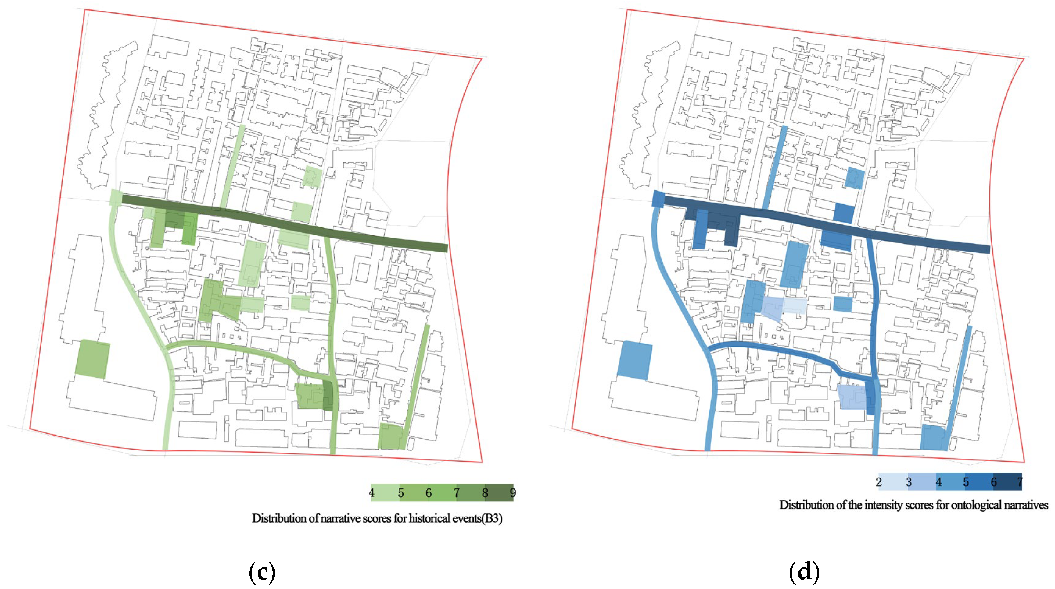
Section 4 presents the empirical results, including diachronic evolution analysis and quantitative evaluations of ontological narrative intensity.
Section 5 discusses the theoretical implications and practical planning strategies derived from the spatial diagnosis.
Section 6 concludes the study with a summary of key findings and future research directions.
2. Literature Reviews
2.1. Conservation and Renewal of Historic Districts and the Need for Microscopic Diagnosis
Historic and cultural districts have long been central to urban planning, heritage conservation, and urban renewal. International heritage conservation concepts have undergone a profound paradigm shift, moving from the conservation of individual monuments to the holistic conservation of historic environments, and from the preservation of physical remains to the continuation of cultural significance and local life. The Venice Charter, the Washington Charter, the Nara Document on Authenticity, and the Historic Urban Landscape approach all emphasize that historic districts are not static physical specimens but dynamic fields continuously shaped by physical space, social networks, cultural memory, and economic activities [
12,
13,
14]. Accordingly, the core of historic district renewal has moved beyond mere architectural restoration and landscape control, toward maintaining the continuity of local life, social relations, and cultural veins, while safeguarding authenticity.
Relevant research is closely linked to rapid urbanization and stock-upgrading practices [
1]. Early studies primarily focused on value identification, landscape control, morphological conservation, and institutional regulation, aiming to curb the destruction of traditional fabrics caused by large-scale demolition and construction [
15]. As urban renewal advances to a more refined stage, the research focus gradually shifts toward organic renewal, micro-renewal, living conservation, and pluralistic governance, emphasizing active responses to practical demands such as functional replacement, tourism development, and livelihood improvement, while protecting the historic environment [
3]. In recent years, with the deepening intervention of cultural tourism capital, the maladies bred during the revitalization of historic districts, such as over-commercialization, spatial homogenization, and the hollowing out of local life, have become increasingly prominent [
16]. Scholars point out that district revitalization should not degenerate into mere commercial implantation and visual scenography but should strive to achieve deep coordination among historical value, daily life, and spatial experience [
4,
17].
In summary, existing literature has laid a solid theoretical and practical foundation for the conservation and regeneration of historic and cultural districts, yet significant limitations remain regarding the research scale. Most studies focus on macroscopic conservation principles, renewal modes, and governance mechanisms, paying insufficient attention to the spatial heterogeneity among microscopic nodes within districts. In fact, the interior of a historic district is by no means a homogeneous space. Different streets, alleys, buildings, nodes, and event venues exhibit stark spatial differentiation in spatial accessibility, functional vitality, historical anchorage, and public cognitive degree. Lacking identification and measurement tools oriented towards microscopic units, renewal practices easily stagnate at the level of overall landscape whitewashing and the homogenization of functional introductions, making it difficult to provide effective support for node-level conservation, precise diagnosis, and differentiated renewal. Therefore, transforming the microscopic spatial units carrying cultural significance within historic districts into identifiable, comparable, and intervenable evaluation objects has become an urgent theoretical and technical bottleneck to overcome in the context of refined urban renewal.
2.2. Spatial Narrative Research and Ontological Turn
Historic and cultural districts differ fundamentally from general built environments not only because they preserve traditional street fabrics and historic buildings but also because of the deep spatial coupling among their physical forms, functional activities, and historical memories that develops over time. Consequently, the crux of historic district renewal lies not only in what to preserve but, more importantly, in how historical meaning is generated, conveyed, and perceived in space [
18]. This inquiry aligns closely with the core concerns of narrative theory.
Traditional narrative theories center on time, events, and texts, often reducing space to a static background or container for narrative occurrence. Accompanying the spatial turn in the humanities and social sciences, space is re-empowered as an active agent in the production of meaning [
19]. Phenomenology emphasizes the construction of place meaning through bodily presence, experiential perception, and dwelling practices. The theory of the sense of place further indicates that spatial uniqueness arises from the intrinsic connection among the natural substrate, the built environment, and life experiences [
20]. The theory of the production of space reveals that space is by no means a neutral geometric container but rather the product of intertwined reconstructions involving daily practices, social relations, and power operations [
21]. Furthermore, studies on collective memory and urban morphology confirm that streets, buildings, and event venues can serve as spatial anchors for memory, elevating urban space into a medium in which historical experiences are continually precipitated and reactivated [
22].
In historic district research, spatial narrative is often used to interpret how historical memory, local identity, and cultural expression are materialized through spatial organization [
11,
23]. Studies have examined how street networks, architectural remains, interpretive systems, and public spaces work together to construct historical narrative frameworks, with applications in cultural exhibitions, heritage tourism, and urban renewal [
24]. However, existing discussions still face two limitations. First, some studies equate spatial narrative with exhibition design, tour route organization, or symbolic collage, falling into the “representationalism” trap that treats narrative as an external thematic addition. Second, most research remains confined to qualitative speculation and case descriptions, lacking in-depth theoretical investigation into how spatial ontology generates narrative capacity and how that capacity can be objectively identified and compared across cases [
25].
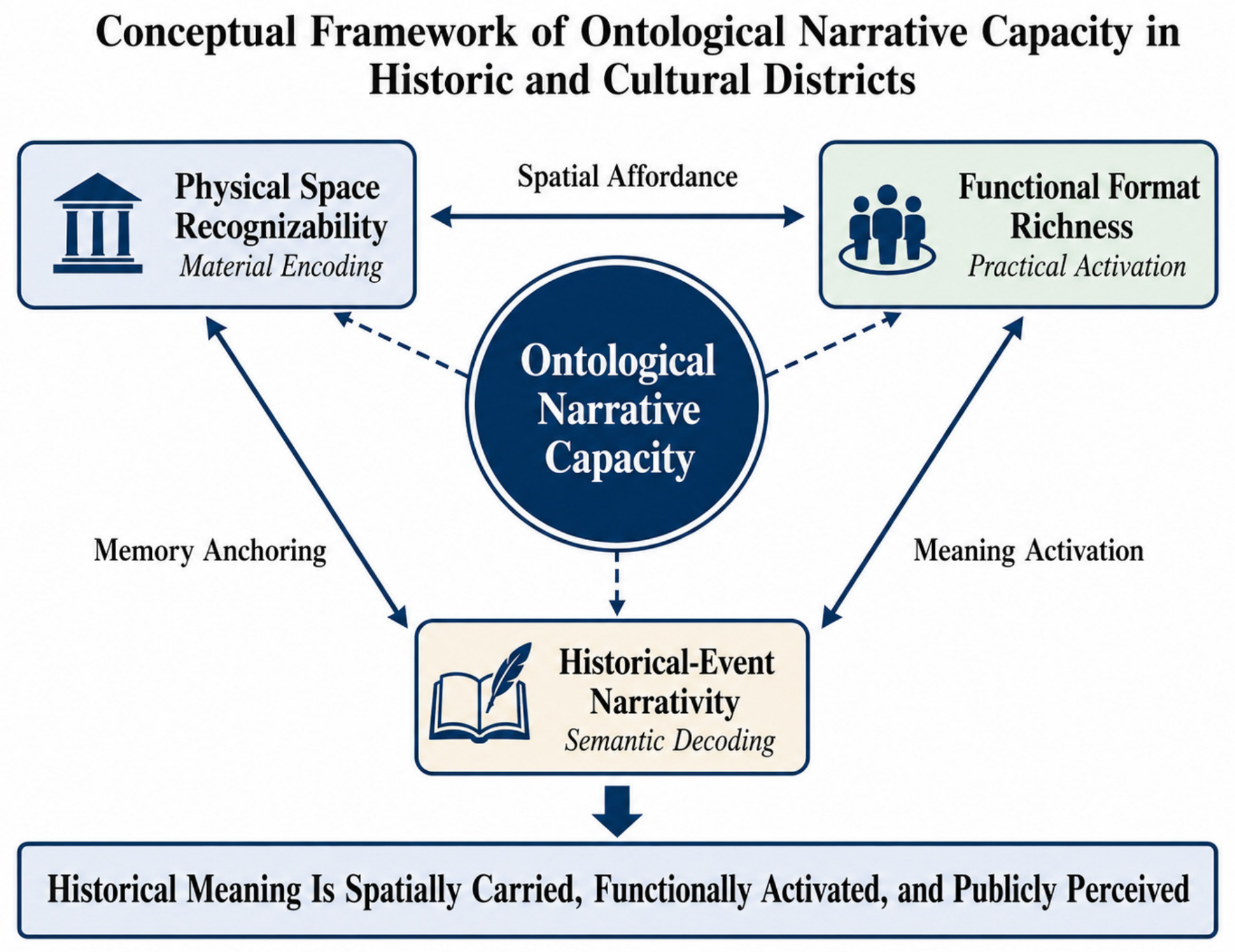
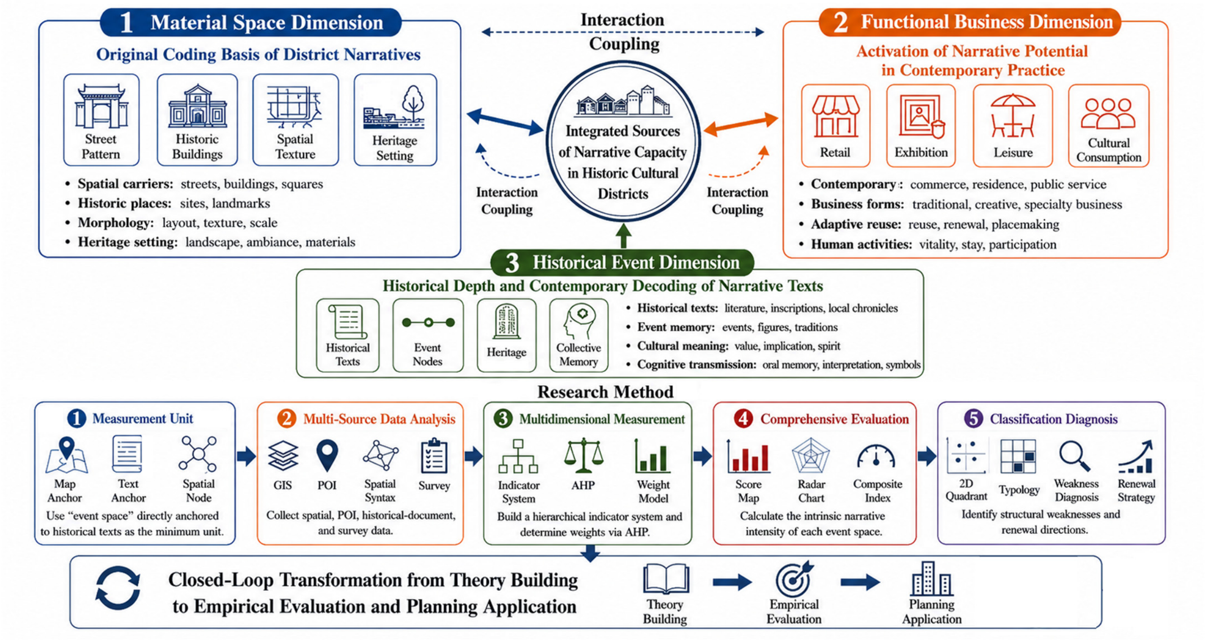
Given this context, this study proposes the concept of “ontological narrative” as the theoretical basis for evaluating historic districts (
Figure 1). In this study, ontological narrative does not refer to external interpretive texts, thematic packaging, symbolic decoration, or staged cultural scenes added to space. Instead, it refers to the endogenous process through which a historic district generates and communicates historical meaning through its own spatial entities, contemporary uses, and historically accumulated events.
More specifically, ontological narrative capacity is produced through the interaction of three dimensions. The first is physical space, which provides the material carrier and perceptual condition for narrative communication. The second is functional format, which activates historical places through contemporary daily use, consumption, and social interaction. The third is historical event narrativity, which provides the narrative’s temporal depth, memory anchor, and semantic content. These three dimensions correspond respectively to material encoding, practical activation, and historical decoding. Only when historical meaning is supported by recognizable physical carriers, activated by contemporary use, and perceived by users can ontological narrative capacity be effectively formed.
Therefore, ontological narrative differs from representational narrative. Representational narrative depends mainly on external scripts, exhibition design, route organization, or symbolic theming. Ontological narrative, by contrast, emphasizes the narrative capacity inherent in the spatial entity itself. It also differs from conventional historical value assessment because it not only asks whether a site has historical significance but also examines whether that significance can be spatially perceived, functionally activated, and experientially decoded in contemporary urban life.
2.3. Quantitative Identification of Narrative Capacity in Historic Districts
As urban studies advance into an evidence-based, data-driven era, research on the conservation, renewal, and spatial narratives of historic districts has increasingly incorporated diverse quantitative methods [
26,
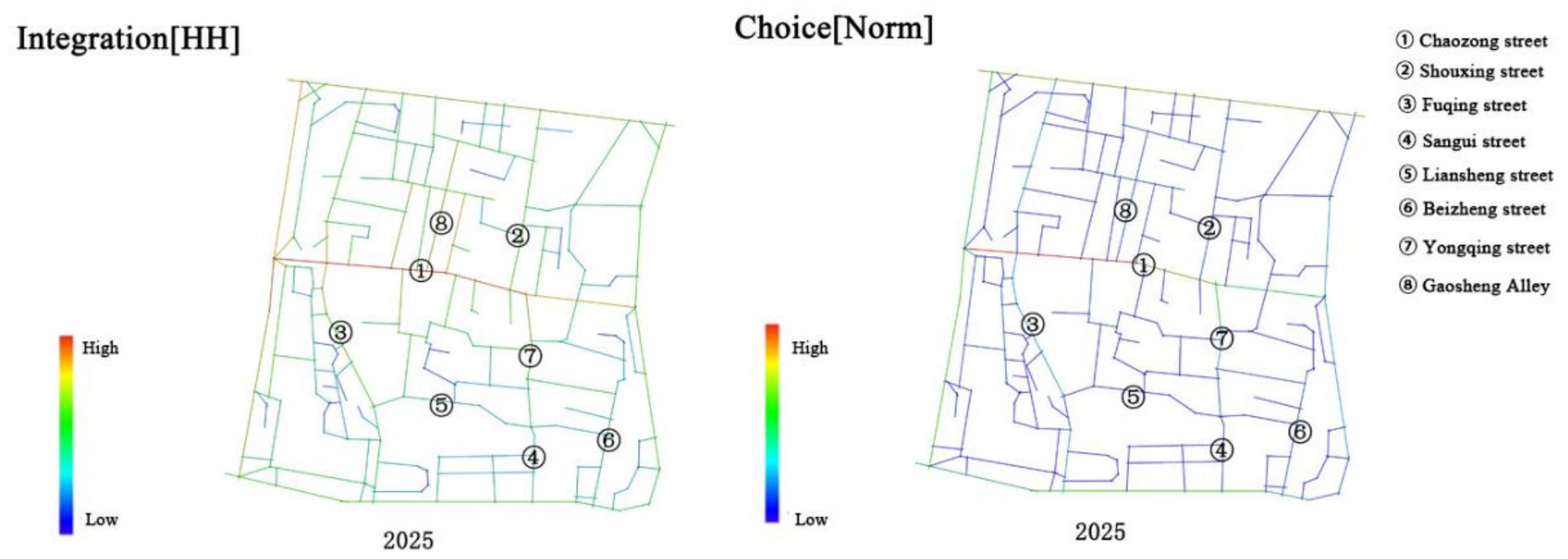
27]. Spatial syntax is frequently used to assess the accessibility, integration, and choice of street networks, thereby revealing how the laws of traditional spatial topology influence the organization of pedestrian flow and spatial cognition [
28]. Geographic information systems (GIS), big data, kernel density estimation (KDE), and functional mix models are widely used to depict the distribution patterns of commercial formats and urban vitality landscapes. Questionnaire surveys, semantic differential methods, and behavioral mapping are commonly used to capture public cognition, spatial experience, and local identity [
29]. Multi-attribute decision-making methods, such as the analytic hierarchy process (AHP), provide mathematical tools for dimensionality reduction and the comprehensive evaluation of heterogeneous indicators [
30].
Although the aforementioned technologies provide high-resolution analytical insights for historic district research, three shortcomings remain in precisely identifying narrative capacity [
31]. First, the misalignment of target dimensions. Existing quantitative studies are mostly anchored in single dimensions such as spatial vitality, conservation performance, tourist perception, or landscape quality, rarely breaking directly into the complex black box of the narrative capacity of historic districts. Second, the fragmentation of analytical frameworks. Different technological pathways lack a unified logical foundation. Spatial syntax excels at analyzing structural potential but struggles to decipher historical texts; big data analysis can map commercial vitality but cannot confirm the activation of historical meaning; perceptual surveys can capture subjective experiences but easily detach from the support of spatial entities; and, finally, the crudeness of evaluation units. Existing assessments mostly target the district as a whole, street segments, or land parcels, and pay little attention to the microscopic nodes that directly carry historical events, personal trajectories, and local memories, failing to match the spatial diagnostic precision required for micro-renewal.
Accordingly, the quantitative diagnosis of ontological narrative capacity requires two methodological shifts. The first is the microscopization of evaluation units, shifting from the district as a whole to event spaces that can precisely anchor historical texts, physical carriers, and public perception. The second is the systematization of the evaluation framework, integrating physical space, functional formats, and historical events into a unified analytical structure.
Based on this logic, this study establishes an event-space-based evaluation framework that combines spatial syntax, POI kernel density estimation, questionnaire surveys, and the Analytic Hierarchy Process. The model does not intend to reduce the complexity of history and culture to a single total score. Instead, it operationalizes ontological narrative capacity into ontological narrative intensity, which serves as a measurable indicator for comparing event spaces and identifying structural mismatch. In this sense, the quantitative score is not equivalent to historical value itself, but a diagnostic representation of the degree to which historical meaning is spatially carried, functionally activated, and publicly perceived.
The theoretical contribution of this study should therefore be understood in relation to three existing research traditions. First, heritage conservation and urban renewal studies have emphasized authenticity, cultural continuity, living conservation, and adaptive reuse. Still, their analytical scale often remains at the district, street block, or conservation policy level. They are less able to explain why different micro-spaces within the same historic district show substantial differences in narrative performance. Second, spatial narrative and cultural memory studies have revealed how historical meaning is embedded in streets, buildings, events, and collective memory. However, these studies are often interpretive and qualitative, and they rarely translate narrative capacity into measurable spatial evidence. Third, quantitative urban morphology and vitality studies provide tools for measuring accessibility, visibility, functional density, and public perception. Still, these indicators are often used in isolation and insufficiently connected to the question of how historical meaning is generated and transmitted.
This study attempts to bridge these gaps by proposing an event-space-based framework for diagnosing ontological narrative capacity. The event space serves as a mediating unit connecting historical texts, physical carriers, contemporary functions, and public perception. The three-dimensional framework is not a simple combination of spatial, functional, and historical indicators. Rather, it is derived from the theoretical mechanism of ontological narrative: physical space provides the material and perceptual carrier, functional formats provide the practical activation mechanism, and historical-event narrativity provides the temporal and semantic content. In this sense, the study contributes to the literature by transforming spatial narrative from a primarily representational and interpretive concept into a measurable, comparable, and diagnosable mechanism for historic district renewal.
2.4. Interdisciplinary Positioning: Disciplinary Fields, Boundaries, and Correlations
This study is positioned at the intersection of urban planning, heritage conservation, spatial narrative research, urban morphology, functional vitality studies, public perception research, and spatial decision support methods. Its primary disciplinary foundation is urban planning and heritage regeneration, as the research problem concerns how historic districts can be assessed and revitalized without reducing cultural heritage to mere physical beautification or homogeneous commercial redevelopment. Heritage conservation and urban renewal studies provide the normative basis of the research, including authenticity, cultural continuity, living conservation, and differentiated regeneration. However, these fields alone are insufficient to explain how historical meaning is generated, perceived, and activated at the micro-spatial scale.
Spatial narrative theory and cultural memory studies provide the conceptual foundation for understanding how historical meaning is embedded in streets, buildings, event sites, and everyday spatial experience. Their contribution lies in explaining the mechanism through which space becomes a medium of memory and meaning. The boundary of this field in the present study is also clear: spatial narrative theory is not used as a purely interpretive or representational framework. Still, it is operationalized through the concept of ontological narrative capacity. In other words, the study does not evaluate external storytelling, exhibition design, or thematic packaging. Still, it focuses on the endogenous narrative capacity generated by spatial carriers, contemporary use, and documented historical events.
Urban morphology and space syntax provide the analytical basis for measuring the physical carrier of narrative capacity. They are used to evaluate street integration, street choice, visual integration, and the spatial recognizability of event spaces. Nevertheless, morphological analysis cannot independently explain historical meaning. Its role is to determine whether a historical site is spatially accessible, visible, and usable. Functional vitality studies and POI-based analysis provide another empirical layer by identifying whether contemporary business formats, daily use, and functional diversity activate historical spaces. However, functional vitality is not equivalent to narrative capacity. A space may be commercially active but historically weak, or historically rich but functionally inactive.
Public perception and place-experience research further supplement the framework by examining whether users cognitively recognize historical events and experientially decode spatial atmospheres. This perceptual dimension prevents the evaluation from being reduced to expert-based morphological judgment or purely objective spatial measurement. Finally, GIS based spatial analysis and multi-criteria decision making methods provide the technical means to integrate heterogeneous indicators into a comparable diagnostic framework. These methods serve as analytical tools rather than theoretical substitutes; they do not replace historical interpretation, field investigation, or planning judgment.
The correlations among these disciplinary fields can therefore be summarized as follows. Heritage conservation and urban renewal define the planning problem and value orientation. Spatial narrative theory explains the mechanism of meaning generation. Urban morphology and functional vitality studies provide measurable evidence for the material carrier and contemporary activation of narrative capacity. Public perception research verifies whether historical meaning is recognized and experienced. GIS and multi-criteria evaluation integrate these heterogeneous dimensions into a spatial diagnostic model. Through this interdisciplinary structure, the present study connects theoretical interpretation, empirical measurement, and planning intervention while maintaining clear disciplinary boundaries.
3. Materials and Methods
The implicit ontological narrative capacity of historic and cultural districts is difficult to measure directly. Based on the interdisciplinary positioning clarified above, this study transforms it into a quantifiable, comparable, and spatially diagnosable empirical object. The methodological framework links heritage regeneration concerns, spatial narrative mechanisms, morphological and functional evidence, public perception data, and multi-criteria spatial evaluation. Building on the theoretical model of ontological narrative, a three-dimensional coupling evaluation framework integrating physical space recognizability, functional format richness, and historical-event narrativity is established.
The empirical technical route comprises five core steps (
Figure 2). First, the research area is defined, and the event space is established as the fundamental unit for microscopic measurement. Second, core event space samples are selected by combining historical document verification with spatial localization. Third, a structured evaluation indicator system is constructed around the three major dimensions of matter, function, and event. Fourth, spatial syntax, POI kernel density estimation, questionnaire surveys, and multi-criteria decision-making models are integrated to measure the ontological narrative intensity of each node quantitatively. Fifth, a two-dimensional diagnostic matrix that integrates comprehensive spatial vitality and historical narrative intensity is introduced to cluster spatial types and diagnose renewal strategies.
3.1. Research Area and Measurement Unit
3.1.1. Research Area
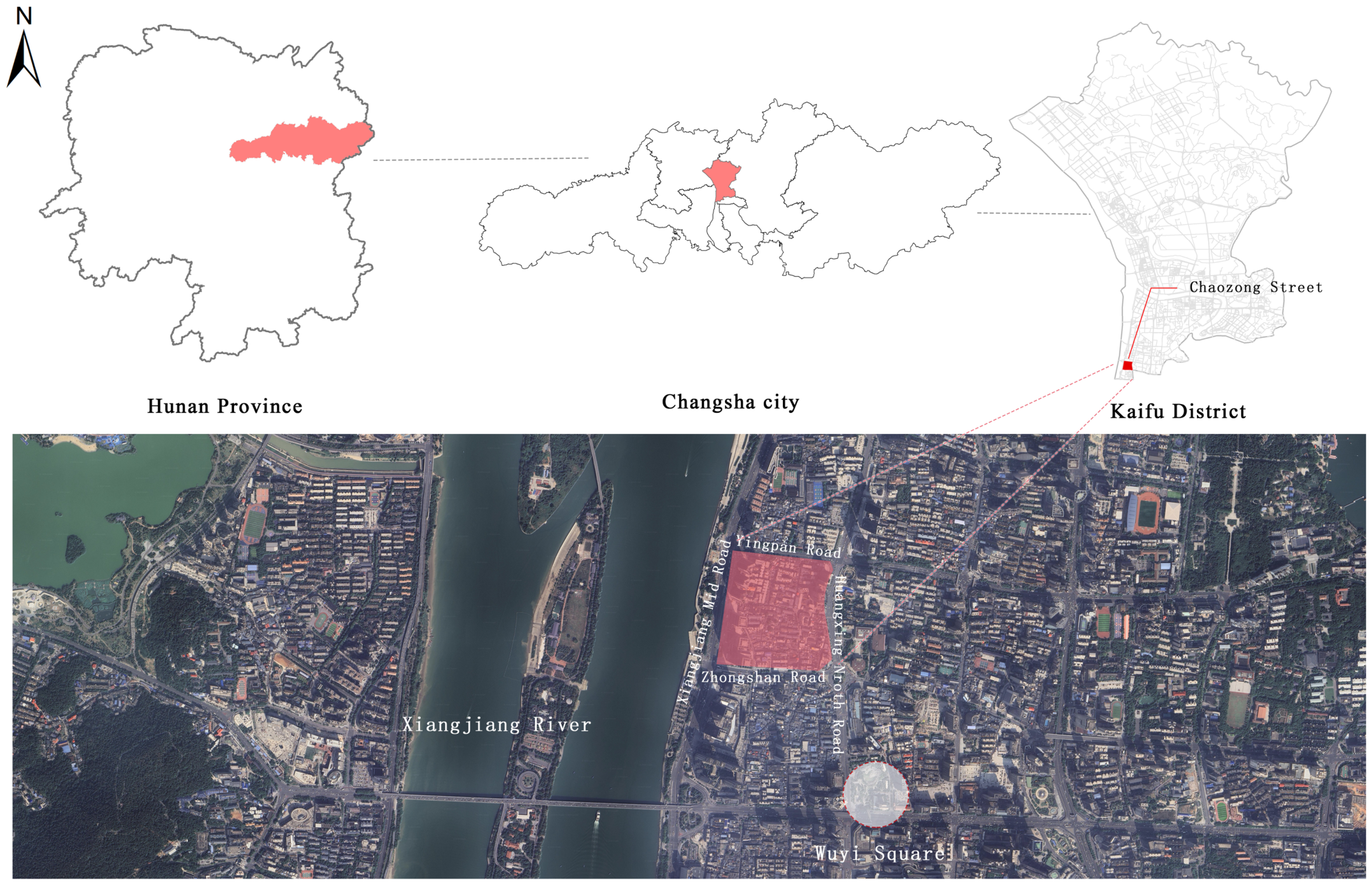
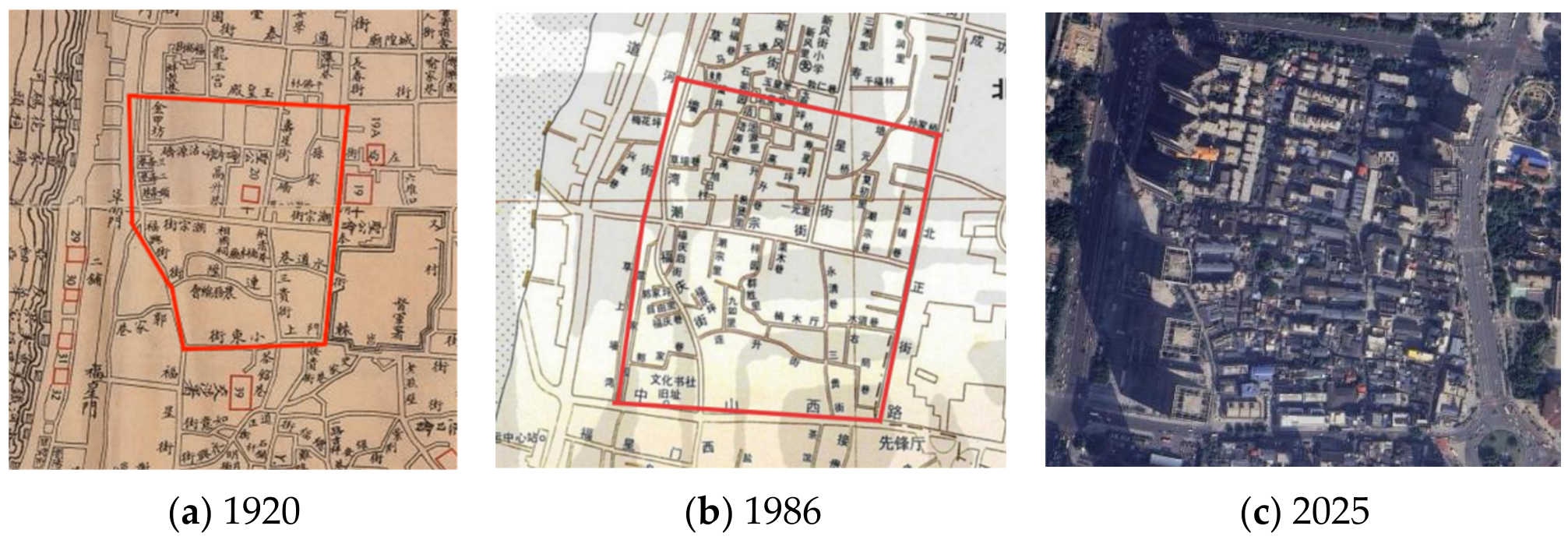
The Chaozong Street historic and cultural district in Changsha is selected as an empirical case (
Figure 3). Located in the core area of the ancient city of Changsha, Chaozong Street is not only one of the areas with the best-preserved traditional street fabric in Changsha but also exhibits extremely profound historical stratification. This district retains a rich physical heritage, including ancient granite streets, traditional courtyards, and modern cultural relics, while simultaneously carrying multidimensional historical memories spanning city defense, commerce, education, revolution, and everyday civic life. In recent years, alongside urban renewal, Chaozong Street has undergone a drastic transition from a traditional mixed residential and commercial area to a complex space for cultural tourism consumption, thereby intensifying the game-playing tension among authenticity conservation, spatial revitalization, and commercial capital intervention in contemporary Chinese historic districts. Therefore, utilizing it as a typical target area for the quantitative identification of ontological narrative capacity holds significant empirical representativeness.
3.1.2. Delineation of Event Spaces
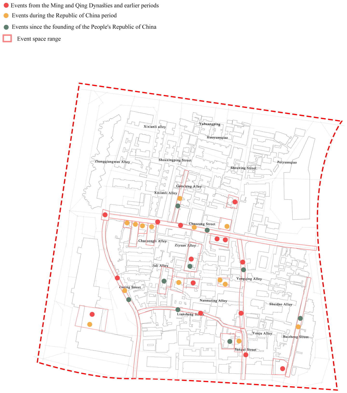
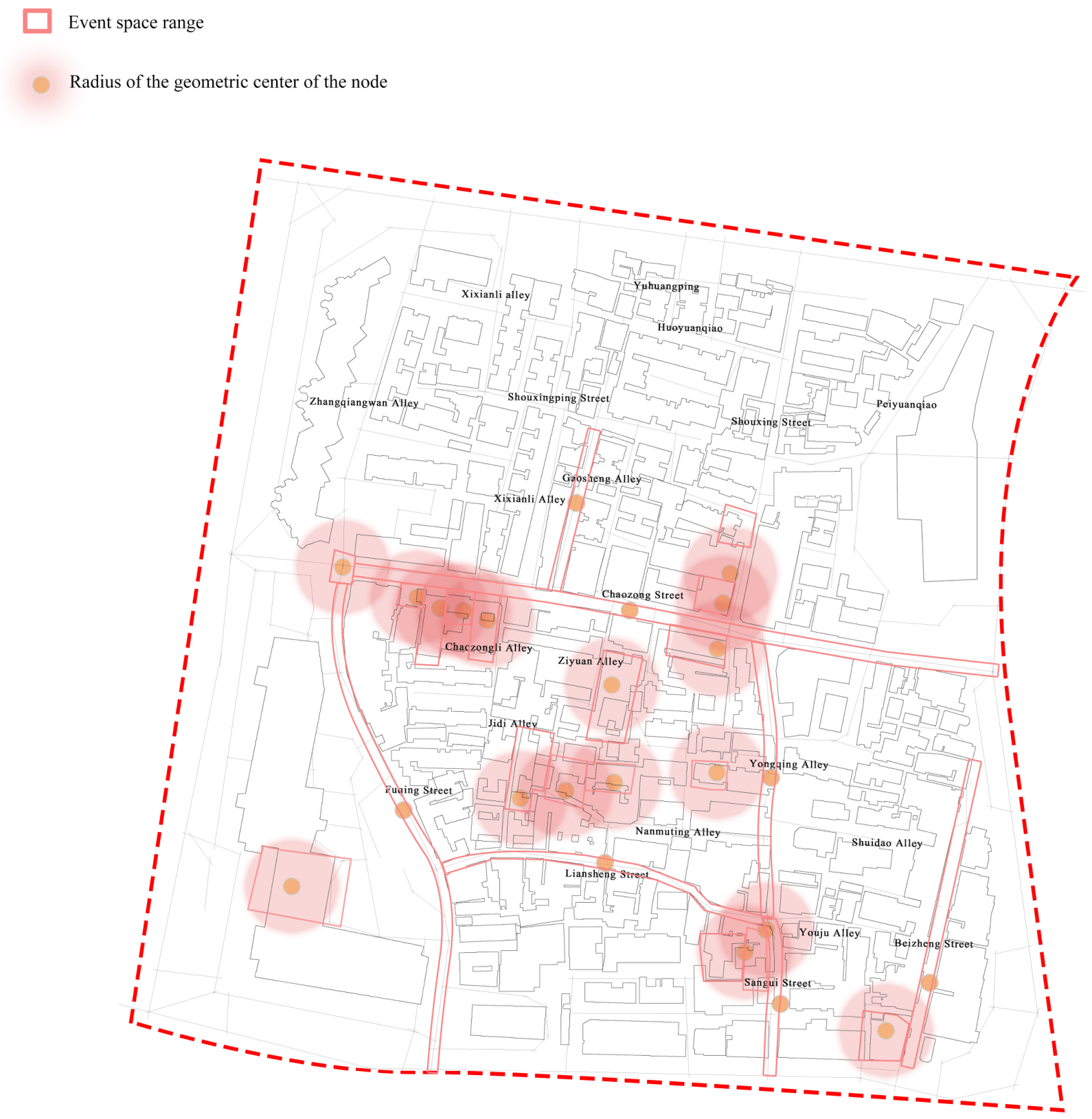
To avoid the fallacy of spatial feature averaging that arises from using macroscopic districts or general land parcels as evaluation units, the event space is introduced as the minimum measurement scale. The event space comprises microscopic geographic nodes within historic and cultural districts that form explicit spatial anchoring relationships with real historical events, key figures’ trajectories, or collective memories. Compared with traditional homogeneous grids, the event space can precisely suture historical texts, physical carriers, and public perceptions, making it an ideal unit for the microscopic analysis of narrative capacity.
A review of local chronicles, historical maps, archival documents, and conservation records was first conducted to identify 37 representative historical events within the historical evolution of Chaozong Street. The complete list of the 37 historical events is provided in
Appendix A. These events constituted the initial pool of historical events. Subsequently, the events were spatially matched with current streets, buildings, ruins, place names, and reconstructable historical locations through on-site surveys, map superimposition, and spatial-position verification. As a result of this process, 24 core event spaces were ultimately selected.
Both inclusion and exclusion criteria guided the selection of event spaces. The inclusion criteria were as follows: first, the event space had to possess reliable historical evidence from local chronicles, archival documents, historical maps, or conservation records; second, it had to have a relatively stable spatial anchoring relationship with specific geographic coordinates or reconstructable spatial boundaries; third, it had to retain physical identifiability in the current state or allow reverse reconstruction through historical maps and multi-source documents; fourth, it had to have sufficient data accessibility for spatial syntax analysis, functional vitality calculation, historical-event measurement, and public perception evaluation.
The exclusion criteria were as follows. First, historical events supported only by vague oral legends, unverified stories, or insufficient documentary evidence were excluded. Second, events that could not be spatially anchored to a specific site, street segment, building, ruin, or reconstructable coordinate were excluded. Third, events located outside the defined boundary of the Chaozong Street historic and cultural district were excluded. Fourth, repeated historical events attached to the same spatial carrier were merged rather than counted as independent event spaces, unless they generated clearly different spatial meanings or narrative functions. Fifth, spaces whose original physical entities had disappeared and whose historical locations could not be reconstructed through maps, documents, or place-name evidence were excluded. Sixth, spaces that were inaccessible for field verification or lacked the minimum data required for spatial syntax, POI-based functional analysis, historical-event measurement, or questionnaire evaluation were excluded.
After applying the above inclusion and exclusion criteria, 13 events were excluded or merged because they lacked independent spatial anchoring, overlapped with other event spaces, exceeded the study boundary, or could not meet the data requirements for quantitative evaluation. Accordingly, the final 24 event spaces were not selected solely through literature review and field observation, but through a structured screening process that combined historical document verification, spatial localization, current identifiability assessment, data accessibility checks, and exclusion-rule control. This procedure ensured that each selected event space could function as a measurable unit connecting historical texts, physical carriers, contemporary use, and public perception.
Given the uneven preservation status of historical remains, the selected event spaces are categorized into three spatial-morphological types. The first is the original site and appearance type, in which historical events correspond directly to existing buildings or physical spaces. The second is the relic-and-ruin type, in which the physical entities are partially obliterated, but clues such as place names, ruined walls, or alleys remain. The third is the virtual coordinate type, in which the original physical entities have completely disappeared, necessitating spatial-position reconstruction based on multi-source historical documents. This classification mechanism ensures that nodes with heterogeneous preservation statuses can be integrated under a unified evaluation benchmark.
3.1.3. Chronological Framework for the Three Analytical Dimensions
Because physical space, functional formats, and historical-event narrativity evolve at different temporal rhythms, this study does not impose a single uniform chronological division on all three dimensions. Instead, a dimension-specific chronological framework is adopted. This framework is based on the internal evolutionary logic of each dimension, the availability and reliability of historical evidence, and the methodological purpose of the diachronic analysis.
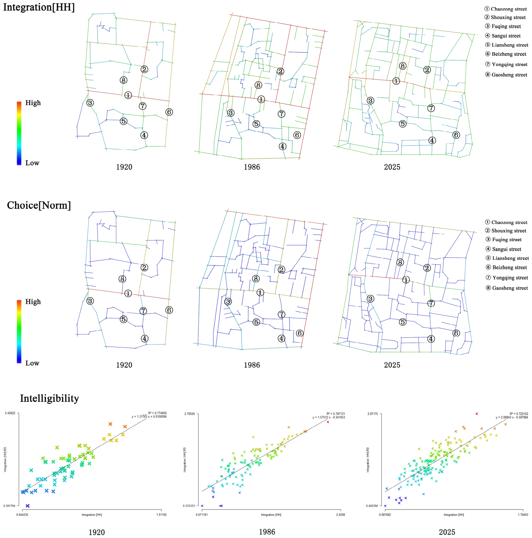
For the physical-space dimension, the study selects 1920, 1986, and 2025 as three representative cross sections. Physical morphology usually changes through long cycle processes, and its analysis depends heavily on historical maps, street network records, and spatial reconstruction. The year 1920 marks the late traditional and early modern stages, during which the street and alley skeleton of Chaozong Street remained relatively intact. The year 1986 represents the high-density residential and spontaneous infill stage, when the internal living network was strengthened, but external connectivity was weakened. The year 2025 represents the contemporary post-renewal stage, reflecting the current spatial condition following micro-renewal and cultural tourism transformation. These three cross-sections are therefore used to examine the long-term transformation of the street network and spatial accessibility.
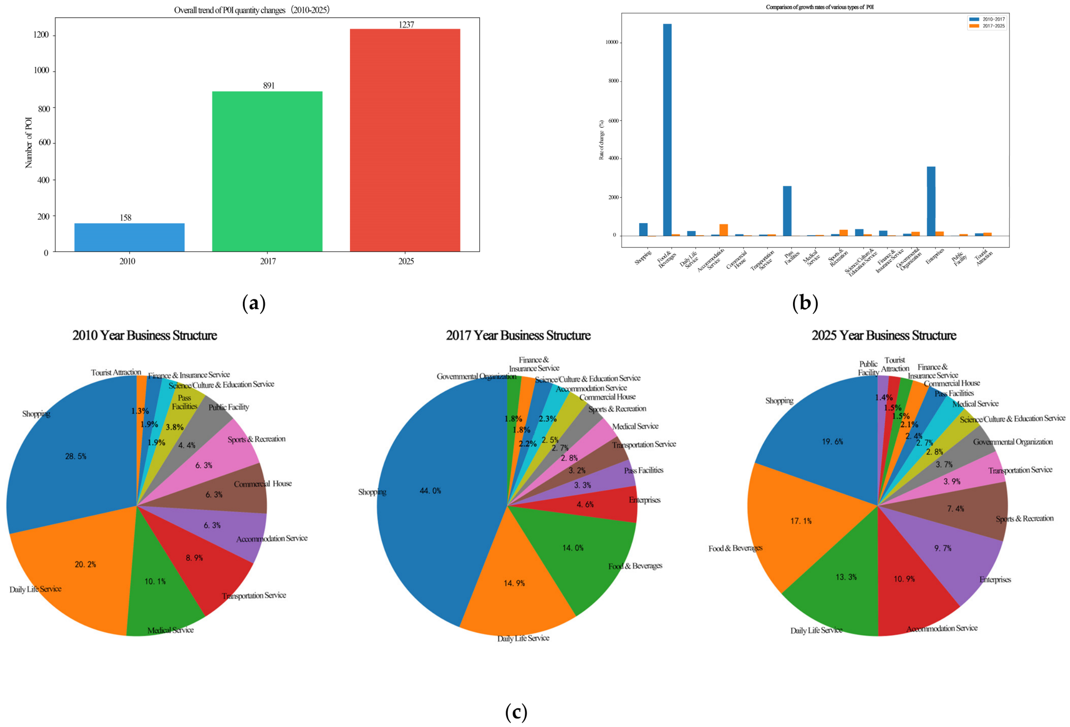
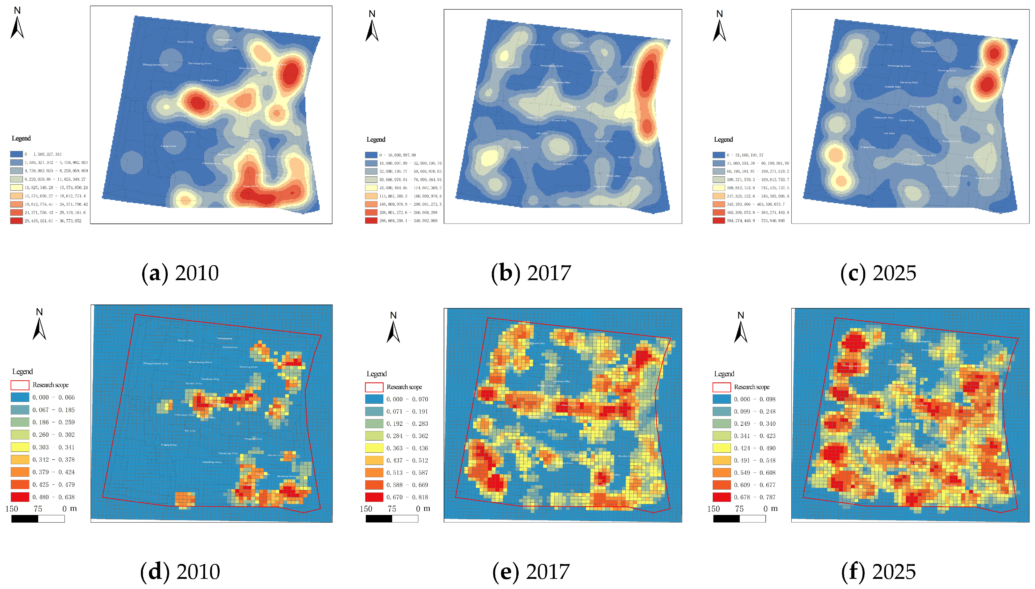
For the functional-format dimension, the study selects 2010, 2017, and 2025 as representative phases. Unlike physical morphology, functional formats change more rapidly and are closely related to recent urban renewal, commercial replacement, and cultural-tourism consumption. In addition, reliable POI and business format data are mainly available for the recent period. The year 2010 represents the pre-renewal stage dominated by residential and basic service functions. The year 2017 marks the initial stage of micro renewal and the implementation of cultural tourism. The year 2025 represents the current stage, in which culturally, commercially, and leisure- and tourism-oriented formats have become more fully developed. These three phases are used to capture the short-cycle transformation of functional density and functional mix.
For the historical event narrativity dimension, the study does not use the same cross-sectional years. Historical event narrativity is produced through long duration accumulation rather than through a few modern temporal slices. Therefore, this dimension adopts a long duration historical inventory, ranging from ancient dynastic periods to contemporary urban memory. Historical events are first identified from local chronicles, historical maps, archival documents, and conservation records. They are then spatially anchored and reorganized into event spaces. This approach allows historical memory and meaning to be connected to current spatial carriers, while avoiding the artificial compression of long term historical accumulation into the same time slices used for physical morphology or functional formats.
In summary, the chronological framework of this study is dimension specific rather than mechanically uniform. The physical-space dimension is examined through long-cycle morphological cross-sections; the functional-format dimension is examined through recent renewal phases; and the historical event narrativity dimension is examined through long duration event accumulation and spatial anchoring. This design ensures that the temporal framework corresponds to the different evolutionary mechanisms of the three components of urban space.
3.2. Evaluation System for Ontological Narrative Intensity
3.2.1. Hierarchical Structure
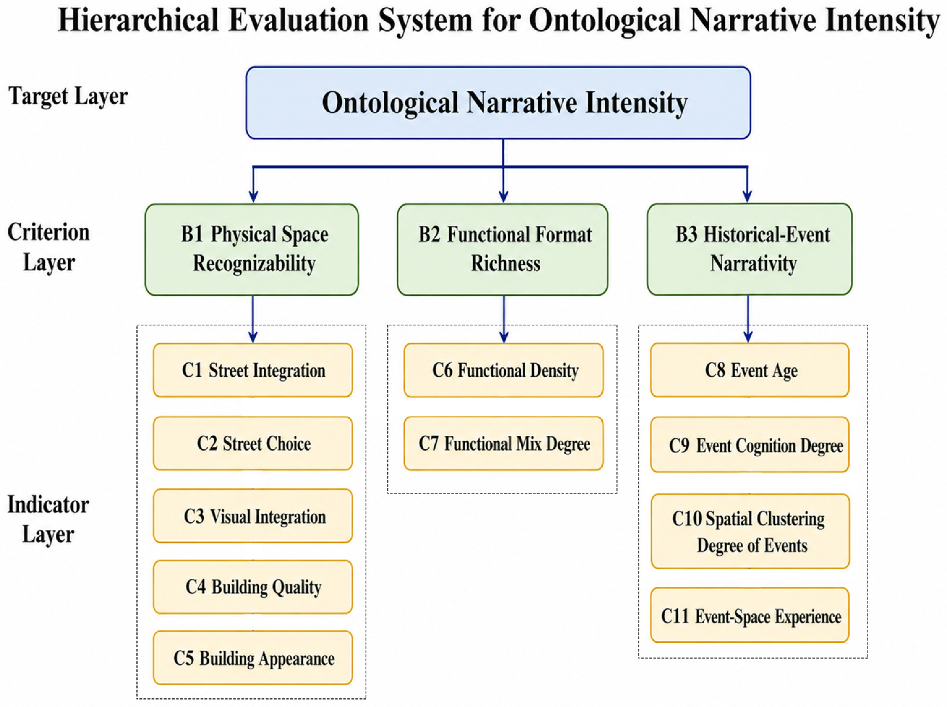
Following the endogenous logic of ontological narrative, a hierarchical evaluation system comprising a target layer, a criterion layer, and an indicator layer is constructed (
Figure 4).
The target layer is ontological narrative intensity. The criterion layer consists of three dimensions: B1 Physical space recognizability, B2 Functional format richness, and B3 Historical-event narrativity. The indicator layer contains eleven indicators, coded from C1 to C11 (
Table 1).
3.2.2. Criterion-Layer Dimension Construction and Indicator Selection Logic
The three criterion-layer dimensions are derived from the generation mechanism of ontological narrative capacity. In this study, narrative capacity is not understood as a symbolic theme added to space from the outside, but as the endogenous capacity of a historic district to make historical meaning spatially carried, functionally activated, and publicly perceived. Therefore, the indicator system is constructed according to three logical links: material carrying, practical activation, and semantic decoding.
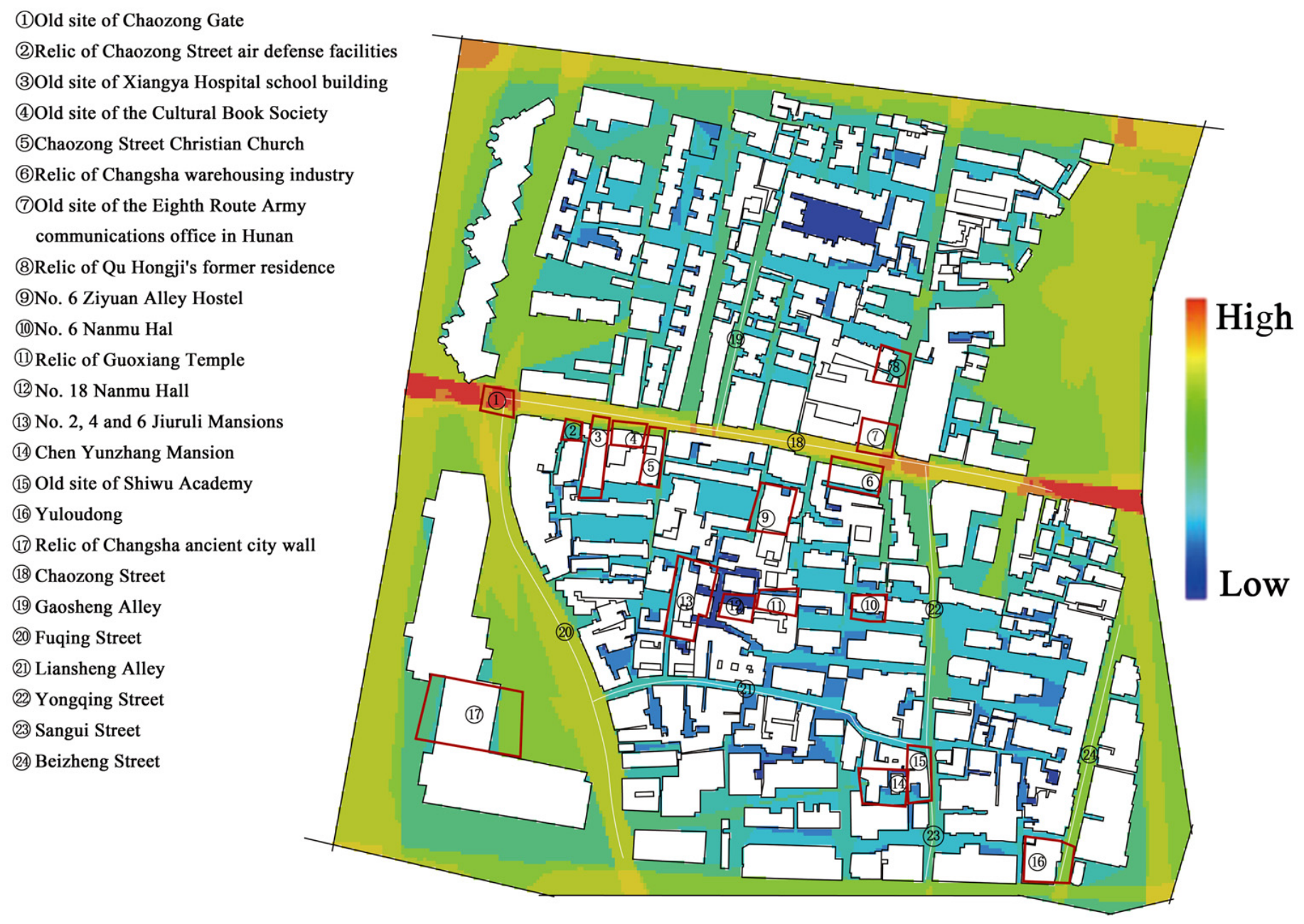
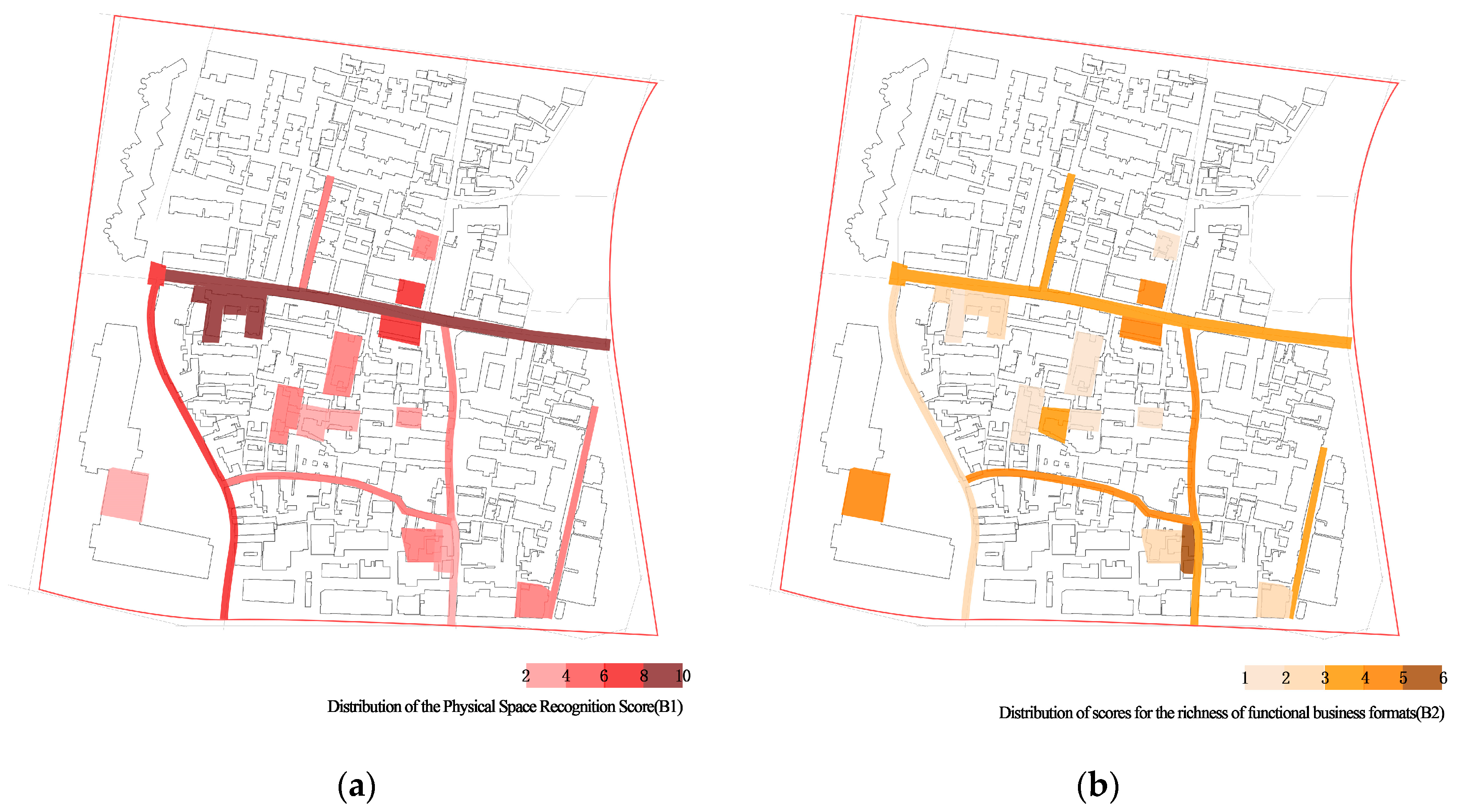
B1 Physical space recognizability corresponds to the material carrying mechanism of ontological narrative. Historical meaning cannot be effectively perceived if it lacks an accessible, visible, and identifiable spatial carrier. This dimension therefore evaluates whether an event space can be physically reached, visually encountered, and materially recognized. C1 Street integration measures the overall accessibility of an event space within the street network. A highly integrated space is more likely to be reached and encountered by users, increasing the opportunity for narrative perception. C2 Street choice measures the probability that an event space lies on the shortest movement path. A higher choice value indicates stronger through-movement potential and greater exposure in everyday spatial practices. C3 Visual integration measures the visual permeability and perceptual accessibility of the event space. It reflects whether historical carriers can be seen, noticed, and cognitively captured. C4 Building quality evaluates the structural integrity, preservation condition, and safety of the architectural carrier. It determines whether the material basis of historical meaning remains stable. The C5 Building appearance evaluation assesses historical style, façade continuity, material compatibility, and landscape coherence. It reflects whether the spatial interface retains sufficient visual legibility to support historical recognition.
B2 Functional format richness corresponds to the practical activation mechanism of ontological narrative. Historical spaces do not automatically generate narrative efficacy merely because they preserve historical remains. They need to be embedded in contemporary daily use, consumption, social interaction, and cultural experience. C6 Functional density measures the intensity of agglomeration of surrounding business and service facilities. It indicates whether sufficient activity concentration and visitor encounter opportunities support an event space. C7 Functional mix degree measures the diversity and balance of different functions. It reflects whether the event space can accommodate multiple uses, including daily life, cultural consumption, leisure, tourism, and social interaction. Together, these two indicators explain whether historical meaning can be activated through contemporary functional use rather than remaining isolated as static heritage.
B3 Historical-event narrativity corresponds to the semantic decoding mechanism of ontological narrative. This dimension evaluates whether an event space has sufficient historical depth, memory anchoring, public recognition, and experiential interpretability. C8 Event age measures the temporal depth of the documented historical event associated with the event space. Older, historically accumulated events usually provide greater temporal thickness and memory depth. C9 Event cognition degree measures the public familiarity with and recognition of the historical event associated with the event space. It reflects whether historical meaning has entered public memory rather than remaining only in archival texts. C10 Spatial clustering degree of events measures the concentration of historical events around the event space. A higher clustering degree indicates that the space is embedded in a denser historical narrative network and has stronger potential for spatial storytelling. C11 Event-space experience measures the public’s perception of spatial atmosphere, cultural meaning, and experiential quality. It reflects whether historical meaning can be decoded through contemporary spatial experience.
Accordingly, the eleven indicators are not selected merely because they are measurable. They correspond to different stages in the formation of ontological narrative capacity. C1–C5 explain whether historical meaning can be spatially carried and perceived; C6–C7 explain whether historical places can be activated by contemporary use; and C8–C11 explain whether historical events can be temporally accumulated, spatially organized, publicly recognized, and experientially decoded. This structure ensures that the evaluation system is theoretically linked to narrative capacity rather than merely an aggregation of heterogeneous spatial indicators. Criterion layer dimension construction and indicator selection logic.
3.3. Data Sources and Indicator Measurement
A multi-source heterogeneous dataset is constructed to measure the three criterion-layer dimensions. The temporal scope of these data follows the dimension-specific chronological framework described above: historical maps are used to reconstruct long-cycle spatial morphology, POI and field-verified business data are used to capture recent functional transformation, and historical texts are used to establish a long-duration inventory of spatially anchored events. The physical space recognizability dimension is measured using spatial morphology data, including OpenStreetMap road network data, high-resolution remote sensing imagery, conservation planning materials, and on-site surveys.
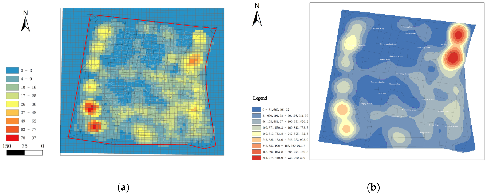
The functional format richness dimension is measured using POI data and field-verified business-format information. POI data were first collected from Gaode Map and then cross-checked through on-site investigation. During the field survey, the research team verified the actual existence, location accuracy, business type, and operating status of each POI. Closed, duplicated, misplaced, or incorrectly classified POIs were removed or corrected. Small shops, courtyard businesses, and alley-based offline commercial facilities that were not recorded in the online POI database were manually supplemented. This procedure was particularly applied to deep alleys and internal residential clusters where online POI coverage is often incomplete. The final functional-format dataset was therefore constructed by combining online POI data with field-verified and manually supplemented business-format information. For kernel density estimation, the output cell size was set at 2 m, and an adaptive search radius corresponding to 50 m was adopted. This parameter setting was determined according to the micro-scale analytical focus of this study, the 24.78 ha size of the study area, and the pedestrian-scale neighborhood effect within the historic district. A smaller radius would produce fragmented point-like density patches due to insufficient smoothing, whereas a larger radius would excessively smooth the internal heterogeneity of the district and obscure the differences between main-street nodes and deep-alley spaces. Therefore, the selected 50 m radius is appropriate for identifying fine-grained functional agglomeration patterns within the historic district.
The historical event narrativity dimension is measured using two types of data. The first type is historical-text data, including local chronicles, historical maps, archival documents, and conservation records. These materials are used to identify historical events, locate their spatial anchors, determine event age, and calculate the spatial clustering degree of events. The second type is public perception data, obtained through structured questionnaires and semantic differential surveys. The questionnaire consisted of two parts. The first part measured the degree of event cognition. Respondents were asked to assess their familiarity with the documented historical events associated with Chaozong Street. A five-level familiarity scale was adopted: “unknown”, “slightly heard”, “generally understood”, “relatively familiar”, and “able to retell”. These five levels were assigned values of 1, 2, 3, 4, and 5, respectively. The cognition score of each historical event was calculated using the weighted average of the response frequencies.
The calculation formula is as follows:
where M
j denotes the average cognition score of the jth historical event;
n_1j,
n_2j,
n3j,
n4j, and
n5j denote the number of responses at the five familiarity levels; and N
j denotes the total number of valid responses for the jth event.
To integrate the cognition scores into the comprehensive evaluation system, the average cognition scores were further converted to a 1–10 scale using linear transformation:
where C10
j denotes the standardized event-cognition degree of the jth event or event space; this transformation preserves the original order of public cognition while making it comparable to the other indicators.
The second part measured event space experience. A seven point semantic differential scale was used to evaluate the perceived spatial atmosphere, cultural meaning, and experiential quality of the 24 event spaces. The scale ranged from −3 to +3, where −3 indicated an extremely negative experience, 0 indicated a neutral experience, and +3 indicated an extremely positive experience. The average semantic differential score of each event space was calculated as follows:
where SD
i denotes the average semantic differential score of the i-th event space;
n_3
i to
n3
i denote the number of responses at each semantic level; and N
i denotes the total number of valid responses for the i-th event space.
The semantic differential scores were then converted to a 1–10 scale:
where C11
i denotes the standardized event-space experience score of the
ith event space; this conversion maps the original semantic differential interval of [−3, +3] onto the unified evaluation interval of [1, 10]. A total of 100 valid questionnaires were retained for the perception-data analysis.
Spatial morphology data are extracted from OpenStreetMap to construct the road-network model for the research area, which is then topologically corrected using high-resolution remote-sensing imagery and on-site surveys. DepthmapX 0.8.0 is used to conduct spatial syntax analysis and extract integration and choice values.
Building quality and Building appearance were assessed through current-status mapping and expert scoring. A 12-member expert panel was invited to conduct the assessment. The panel consisted of scholars and practitioners from urban planning, architecture, heritage conservation, and historic district renewal. Before scoring, all experts were provided with the same evaluation materials, including field survey records, current-status photographs, conservation planning documents, historical maps, and spatial location information for the 24 event spaces.
C4 Building quality was used to evaluate the physical preservation condition of the architectural carrier. The scoring criteria included structural integrity, safety, material preservation, maintenance condition, and the degree of physical deterioration. The appearance of the C5 Building was used to evaluate the visual and stylistic coherence of the architectural carrier. The scoring criteria included historical style, façade continuity, material and color compatibility, interface integrity, and coordination with the surrounding historic landscape.
Both indicators were scored on a 1–10 scale. For Building quality, scores of 1–2 indicate severely damaged or physically disappeared carriers; scores of 3–4 indicate poor structural or maintenance condition; scores of 5–6 indicate basically preserved but partially deteriorated buildings; scores of 7–8 indicate good preservation condition and structural integrity; and scores of 9–10 indicate excellent preservation and high physical integrity. For Building appearance, scores of 1–2 indicate that the original historical style is largely lost or visually incompatible; scores of 3–4 indicate serious façade alteration or weak stylistic continuity; scores of 5–6 indicate partial preservation of historical appearance; scores of 7–8 indicate clear historical style and good façade continuity; and scores of 9–10 indicate outstanding historical appearance and strong landscape coherence.
Each expert independently scored the 24 event spaces. The final score of each event space was calculated as the arithmetic mean of all valid expert scores. For virtual-coordinate-type event spaces whose original physical entities had disappeared, the score was based on the current visible spatial carrier and the degree to which the historical location could still be physically identified. If no visible architectural carrier remained, the building-quality and building-appearance scores were assigned a low value. At the same time, their historical significance was still evaluated separately through the historical-event narrativity dimension.
3.4. Weight Determination and Entropy-Weight Comparison
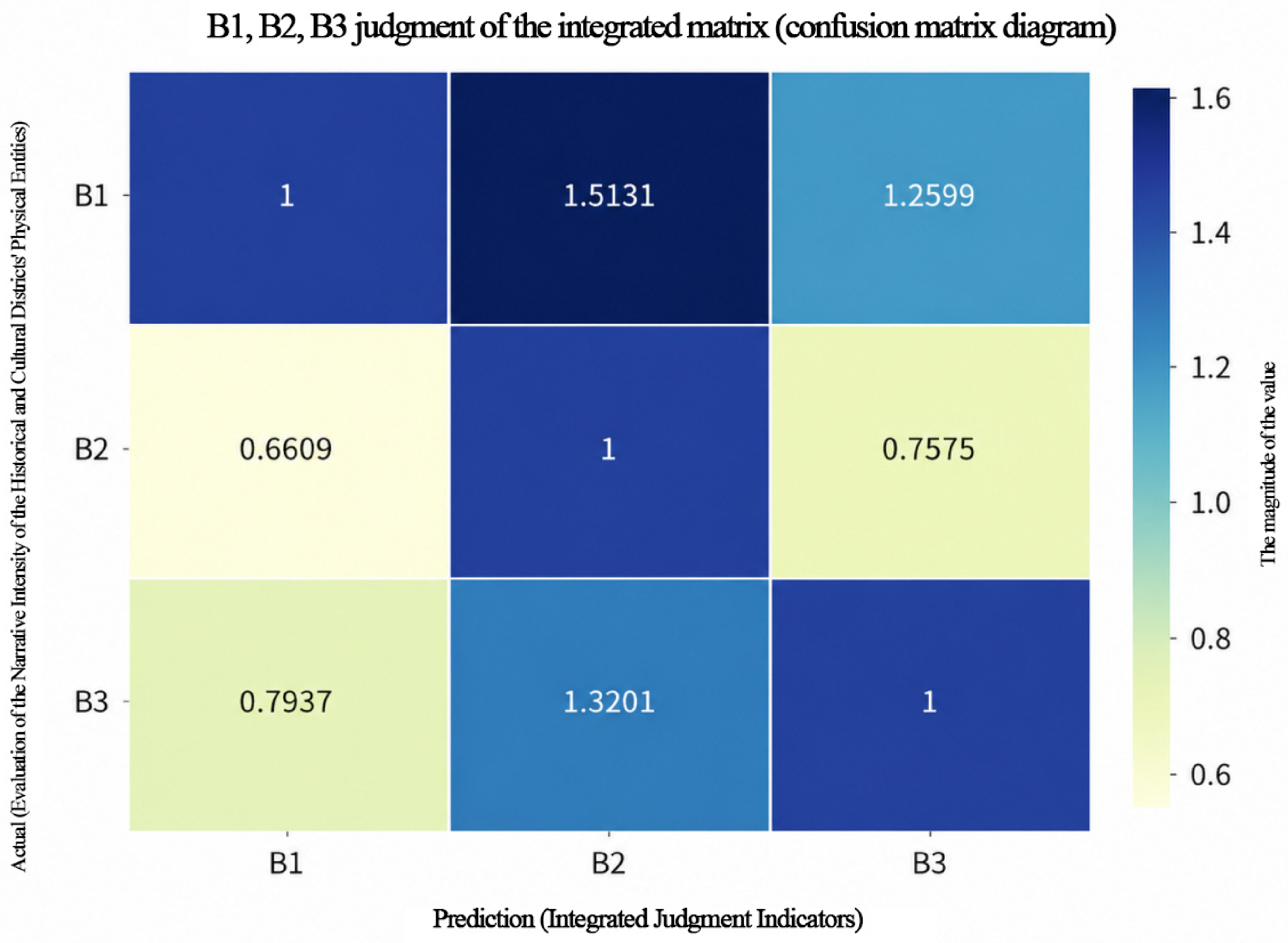
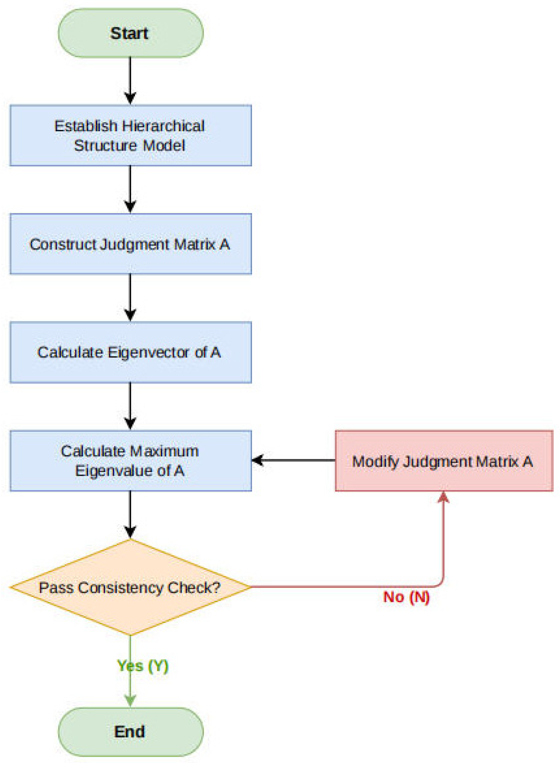
Given that ontological narrative evaluation involves both objective spatial attributes and subjective cultural judgments, the Analytic Hierarchy Process is adopted as the final weighting method in this study. AHP is suitable for this research because the relative importance of indicators cannot be determined solely by statistical dispersion; it also depends on theoretical judgment regarding heritage interpretation, spatial perception, functional activation, and the transmission of narrative meaning. (
Figure 5).
Twelve senior scholars and practitioners in urban planning, architecture, heritage conservation, and historic district renewal were invited to serve on an expert evaluation panel. The AHP procedure was conducted in four steps.
First, a hierarchical structure was established, including the target layer, the criterion layer, and the indicator layer. The target layer was ontological narrative intensity. The criterion layer consisted of B1 Physical space recognizability, B2 Functional format richness, and B3 Historical-event narrativity. The indicator layer consisted of 11 indicators, C1 through C11.
Second, the experts independently constructed pairwise comparison matrices using Saaty’s 1–9 scale. In this scale, 1 indicates equal importance between two elements, 3 indicates moderate importance, 5 indicates strong importance, 7 indicates very strong importance, and 9 indicates extreme importance. The intermediate values 2, 4, 6, and 8 were used when the judgment fell between two adjacent levels. Reciprocal values were used for inverse comparisons.
Third, the valid expert judgments were aggregated using the geometric mean method. For each pairwise comparison element, the geometric mean of the 12 expert judgments was calculated to form an integrated group judgment matrix. The final criterion-layer and indicator-layer weights were then derived from this integrated matrix. This procedure ensured that the final AHP weights reflected collective expert judgment while satisfying the consistency requirement.
The calculation model for the comprehensive score of ontological narrative intensity for each event space is formulated as follows.
In the formula, Si denotes the ontological narrative intensity of the ith event space; wj denotes the comprehensive weight of the jth indicator; Xij denotes the standardized score of the i-th event space on the j-th indicator; and m denotes the number of indicators.
To verify the model’s robustness, an additional weight sensitivity analysis is conducted. This analysis applies single-factor perturbations of ±10% and ±20% to the criterion layer weights, and the residual weights are then normalized and reorganized.
To avoid relying solely on subjective expert judgment, the entropy weight method was further introduced as an objective comparison. The entropy method calculates indicator weights based on the degree of information differentiation in the standardized data matrix. In this study, entropy weights were calculated using a standardized matrix of 24 event spaces and 11 indicators. Let X = (xij)n × m denote the standardized indicator matrix, where
n = 24 represents the number of event spaces and m = 11 represents the number of indicators. The proportion of the i-th event space under the j-th indicator is calculated as follows:
The entropy value of the
j-th indicator is calculated as follows:
The information utility value of the
j-th indicator is calculated as follows:
Finally, the entropy weight of the
j-th indicator is calculated as follows:
where w
jE denotes the objective entropy weight. A higher entropy weight indicates that the indicator has a stronger ability to differentiate among the 24 event spaces.
3.5. Coupling Coordination Degree Model
To further quantify the interaction mechanism among the three criterion-layer dimensions, this study introduces a coupling coordination degree model. The comprehensive score of ontological narrative intensity reflects the overall narrative level of each event space. Still, it cannot fully reveal whether physical space recognizability, functional format richness, and historical-event narrativity develop synchronously. Therefore, the coupling coordination degree model is used as a supplementary diagnostic method to identify coordination and mismatch among the three dimensions.
Let B
1i, B
2i, and B
3i denote the original scores of physical space recognizability, functional format richness, and historical-event narrativity of the
i-th event space, respectively. Since the dimension scores in this study are standardized on a 1–10 scale, they are first converted to a 0–1 scale:
where U
1i, U
2i, and U
3i denote the normalized values of physical space recognizability, functional format richness, and historical-event narrativity of the
i-th event space, respectively.
The coupling degree of the three dimensions is calculated as follows:
where C
i denotes the coupling degree of the
i-th event space; the coupling degree reflects the relative balance among the three dimensions. A higher C
i indicates that physical space recognizability, functional format richness, and historical event narrativity are more evenly developed. However, the degree of coupling primarily reflects dimensional balance and does not represent the overall level of development.
Therefore, the comprehensive development index is further calculated as follows:
where T
i denotes the comprehensive development index of the i-th event space, and the parameters α, β, and γ denote the criterion-layer weights of physical space recognizability, functional format richness, and historical-event narrativity, respectively.
Finally, the coupling coordination degree is calculated as follows:
where D
i denotes the coupling coordination degree of the
i-th event space; a higher D
i indicates a higher level of coordinated development among physical space recognizability, functional format richness, and historical-event narrativity. Compared with the coupling degree alone, the coupling coordination degree integrates both dimensional balance and the level of comprehensive development.
In this study, the coordination levels are classified as follows: 0.50 ≤ Di < 0.60 indicates primary coordination; 0.60 ≤ Di < 0.70 indicates intermediate coordination; 0.70 ≤ Di < 0.80 indicates good coordination; and Di ≥ 0.80 indicates high coordination. The coupling coordination degree model is not used to replace the comprehensive ontological narrative intensity score. Rather, it is used to reveal whether an event space suffers from spatial shielding, functional insufficiency, or weak historical-event decoding.
3.6. Type Diagnosis
A single comprehensive score of ontological narrative intensity can reveal the overall narrative condition of each event space. Still, it may obscure structural mismatches among spatial support, functional activation, and historical meaning. Therefore, this study further constructs a two-dimensional diagnostic matrix to distinguish different forms of coupling and decoupling.
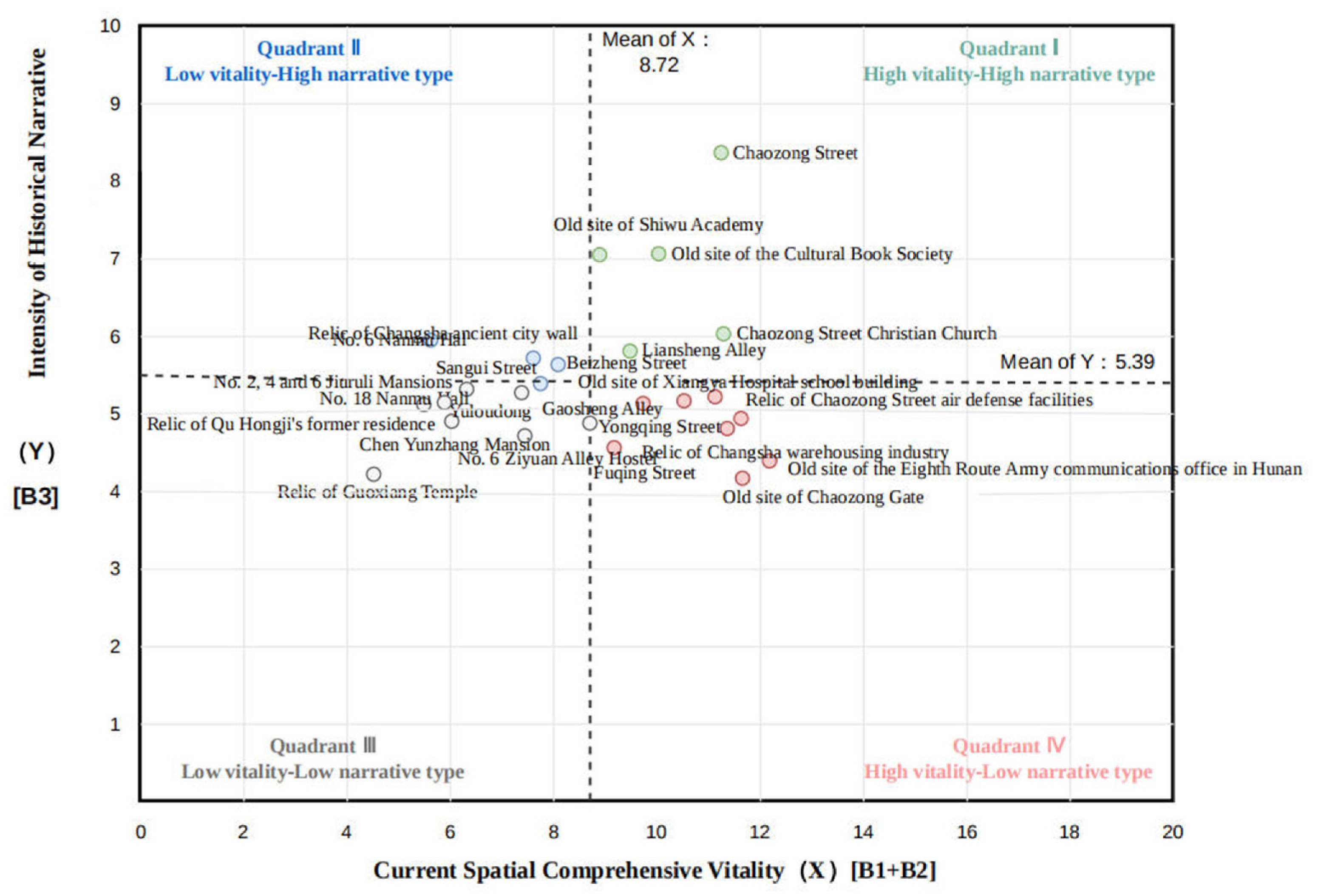
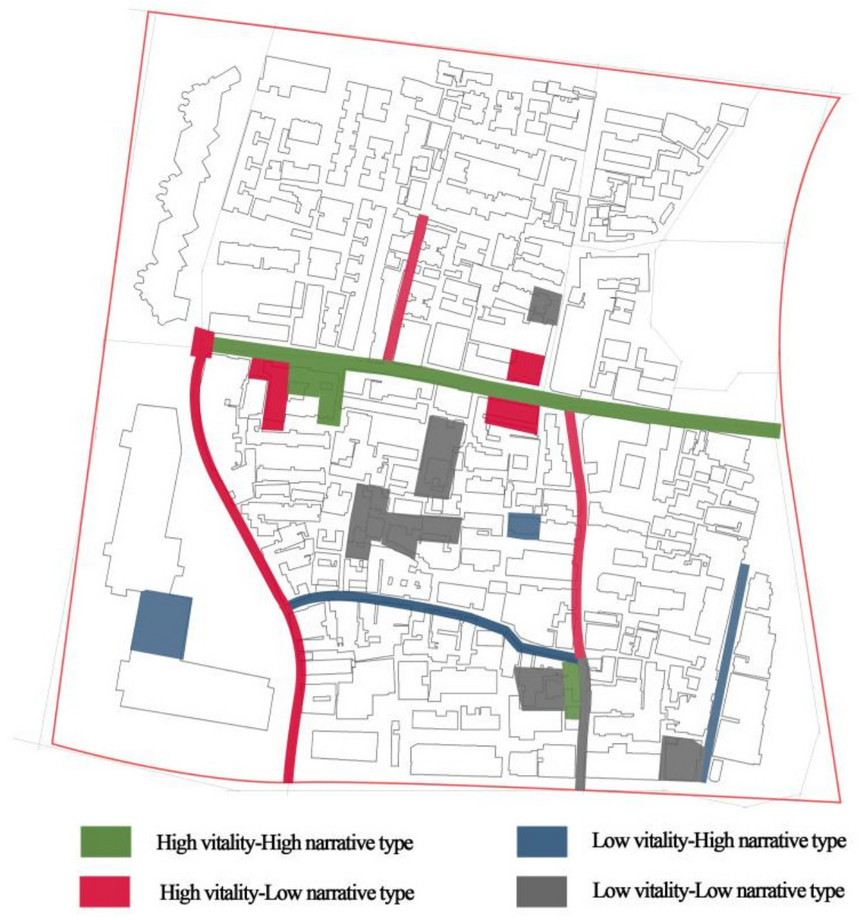
The horizontal axis represents spatial vitality. In this study, spatial vitality does not refer merely to commercial prosperity. It is a composite diagnostic dimension derived from physical space recognizability and functional format richness, indicating whether an event space is accessible, visible, physically identifiable, and supported by contemporary functions. The vertical axis represents historical narrative intensity, indicating the extent to which users perceive and decode historical events, collective memory, and spatial experience. Using the sample mean as the coordinate origin, the 24 event spaces are classified into four types: high spatial vitality–high historical narrative intensity (HH), low spatial vitality–high historical narrative intensity (LH), low spatial vitality–low historical narrative intensity (LL), and high spatial vitality–low historical narrative intensity (HL).
This matrix is not intended to introduce another independent evaluation system. Rather, it decomposes the comprehensive ontological narrative intensity into two diagnostic dimensions, thereby revealing whether a space suffers from insufficient activation, weak historical decoding, or a simultaneous decline in both.
5. Discussion
5.1. Methodological Breakthrough in the Quantitative Identification of Ontological Narrative
The theoretical contribution of this study lies in repositioning spatial narrative research within the context of historic district renewal. Existing heritage conservation studies have emphasized authenticity, cultural continuity, adaptive reuse, and living conservation, but they often focus on conservation principles, district-level value assessment, or governance strategies. Existing spatial narrative studies have clarified how historical meaning is constructed through spatial form, memory, and experience, but they tend to remain qualitative and interpretive. Existing quantitative studies on urban morphology, functional vitality, and public perception provide measurable indicators, but they often treat physical space, functional use, and historical resources as separate analytical dimensions. As a result, the internal mechanism through which historic districts generate narrative capacity at the micro-spatial scale remains insufficiently explained.
This study responds to this gap by proposing the concept of ontological narrative capacity and operationalizing it through the event-space unit. The theoretical shift is from external narrative representation to endogenous narrative generation. In this framework, narrative capacity is not produced by thematic decoration, route packaging, or symbolic display alone. It is generated through the interaction among three mechanisms: physical space provides the material and perceptual carrier of historical meaning; functional formats activate historical places through contemporary use and social encounter; and historical-event narrativity provides temporal depth, memory anchoring, and semantic content. This framework allows narrative capacity to be understood not as an abstract cultural attribute, but as a spatially embedded and empirically diagnosable mechanism.
The selected indicators are therefore theoretically connected to narrative capacity. Indicators of street integration, street choice, visual integration, building quality, and building appearance measure whether historical meaning can be spatially carried and perceived. Indicators of functional density and functional mix degree measure whether historical spaces can be activated through contemporary activities. Indicators of event age, spatial clustering degree of events, event cognition degree, and event-space experience measure whether historical events can be temporally accumulated, spatially organized, publicly recognized, and experientially decoded. Through this structure, the study integrates heritage conservation, spatial narrative theory, urban morphology, functional vitality, and public perception into a unified diagnostic framework.
Compared with previous studies that either interpret narrative meaning qualitatively or measure spatial vitality independently, this study provides a mechanism-oriented quantitative framework. It does not equate narrative capacity with historical value, commercial vitality, or spatial accessibility alone. Instead, it demonstrates that narrative capacity emerges from the coupling among material carrier, functional activation, and historical-event decoding. This theoretical positioning strengthens the link between spatial narrative theory and evidence-based micro-renewal. It provides a basis for diagnosing why some historically rich spaces remain weak in public perception, while some commercially active spaces fail to transmit historical meaning.
Furthermore, using the event space as the fundamental unit of measurement is a crucial entry point for overcoming the scale limitations of traditional research. Traditional studies often treat historic districts as homogeneous wholes, and this tends to obscure internal spatial heterogeneity through averaging effects. By descending to the microscopic level of event spaces, this study more precisely anchors the relationship between historical texts and real-world coordinates. In this way, ontological narrative is not treated as an abstract philosophical label, but is operationalized into measurable spatial evidence. The purpose of this framework is therefore not to introduce additional terminology for its own sake, but to clarify the relationship between a theoretical construct, namely ontological narrative capacity, and its empirical expression, namely ontological narrative intensity. This clarification provides a more precise basis for node-level diagnosis and differentiated renewal strategies in historic districts.
5.2. Synergistic Evolution Mechanisms of Ontological Narrative in Historic Districts
First, the topological network of physical space is a prerequisite for narrative performance. All frequently activated nodes occupy core, advantageous areas of the road network, indicating that the physical accessibility and visual penetrability of the space itself directly determine the likelihood that the public will capture historical texts. Conversely, for those branch alley nodes deeply trapped in topological islands, even with profound historical heritage, their narrative potential remains dormant due to physical shielding.
Second, the daily network of functional formats is the core engine for activating ontological narrative capacity. The transformation of historic commercial districts should not be reduced to the physical addition of commercial facilities. Contemporary spatial activities need to go beyond material consumption and become carriers through which historical meaning can be encountered, interpreted, and experienced. The revitalization trajectory of Chaozong Street confirms that when historical nodes are detached from the daily network of contemporary urban life, their narrative efficacy tends to decline. Conversely, when commercial prosperity is pursued without sufficient cultural anchoring, high-vitality yet low-narrative spaces may emerge, leading to a rupture between functional activation and the transmission of historical meaning.
Finally, the preservation of historical texts serves as a cultural anchor, endowing space with semantic depth. Research findings suggest that historical texts do not inevitably translate into effective perception. Certain nodes with high-level historical value are completely marginalized in the public cognitive system due to a lack of physical spatial support or exhibition media. This profoundly demonstrates that historical memory cannot take effect automatically, and that its translation into public experience relies heavily on spatial media, the creation of experiential scenes, and the generation of realistic opportunities for contact.
The degree of coupling coordination further confirms the synergistic mechanism of ontological narrative. Some event spaces show relatively high degrees of coupling but only moderate or primary coordination because their comprehensive development index remains low. This indicates that balance among the dimensions is not sufficient; the three dimensions must also reach a certain level of development. For example, several deep-alley nodes preserve historical-event narrativity, but their weak functional activation and limited accessibility reduce their overall degree of coordination. Conversely, main-street nodes tend to achieve higher coordination because physical accessibility, contemporary functional exposure, and historical perception are more likely to reinforce one another. Therefore, the failure of ontological narrative is not caused by the absence of a single element alone, but by the disconnection among spatial carrier, functional activation, and historical-event decoding.
In summary, ontological narrative is an inseparable three-dimensional linkage mechanism, and the collapse of any single dimension will trigger a holistic failure of the spatial narrative system.
5.3. Three-Dimensional Decoupling and Its Planning Implications
The most policy relevant finding of this evaluation system is the identification of structural decoupling among physical space, functional activation, and historical event narrativity. The four-quadrant diagnosis should not remain a descriptive classification. It can be further translated into type specific renewal rules for design intervention, operational organization, and management control. Accordingly, this study proposes differentiated renewal rules for the four types of event spaces: HH, LH, LL, and HL.
For HH spaces, the main task is not large scale redevelopment but conservation based management. These spaces already show a relatively strong coupling among spatial recognizability, functional activation, and historical narrative intensity. Therefore, the design intervention should focus on protecting historical interfaces, controlling façade renovations, maintaining visual corridors, and improving small-scale public facilities without damaging the original spatial character. Operationally, HH spaces should be used as core narrative anchors in district level cultural routes, guided tours, public education activities, and seasonal cultural events. However, excessive visitor concentration and repetitive commercial implantation should be avoided. In terms of management, a conservation priority control list should be established, including restrictions on signboards, façade materials, business replacement, nighttime lighting, and temporary commercial installations. Regular monitoring of visitor flow, building condition, and public perception should be conducted to prevent high-intensity use from weakening historical authenticity.
For LH spaces, the core problem is not the absence of historical resources but insufficient spatial exposure and functional activation. These spaces usually contain strong historical event narrativity but are hidden in branch alleys, enclosed courtyards, or weakly connected internal spaces. Design intervention should therefore focus on micro-circulation improvement, entrance identification, wayfinding signage, lighting, pavement repair, barrier free access, and small interpretive nodes. The purpose is to guide visitors from main streets into deep alleys without destroying the existing historical fabric. Operationally, LH spaces are suitable for low-intensity and culture-oriented functions, such as small exhibitions, archival displays, local history workshops, cultural bookstores, community classrooms, craft studios, or guided interpretation points. Management should avoid aggressive commercial redevelopment and instead use public–private cooperation, low-rent cultural incubation, and periodic cultural programming to gradually activate dormant historical resources.
For LL spaces, the priority is basic environmental repair and incremental narrative cultivation. These spaces are weak in both spatial vitality and historical narrative intensity. They are often located at the ends of the road network, in enclosed residential clusters, or in physically deteriorated areas. Design intervention should first address safety, accessibility, drainage, lighting, pavement quality, façade maintenance, and public-space cleanliness. Before introducing cultural tourism functions, the living environment and basic public services should be improved. Operationally, LL spaces should not be converted into tourist-consumption spaces immediately. More appropriate measures include community memory collection, resident-led micro-exhibitions, neighborhood cultural activities, and the gradual introduction of daily service functions. In terms of management, incremental renewal should be adopted. Residents, property owners, community organizations, and planning departments should jointly define maintenance responsibilities, renewal phases, and acceptable intervention intensity. The key is to prevent marginal spaces from being either ignored or abruptly commercialized.
For HL spaces, the main problem is narrative decoupling under strong spatial vitality. These spaces have good accessibility and high functional exposure, but their commercial formats or spatial interfaces are weakly connected to local historical meaning. Design intervention should focus on cultural re-anchoring rather than additional commercialization. This includes reducing visual clutter, controlling signboard scale, restoring historically compatible façade elements, embedding historical interpretation into shopfronts and public spaces, and improving the continuity between commercial interfaces and historical context. Operationally, commercial tenants should be encouraged or required to incorporate local history, place memory, or district-specific cultural elements into products, exhibitions, services, or visitor experiences. Generic retail, homogeneous catering, and purely decorative themed consumption should be restricted. Management should establish a business-format admission and evaluation mechanism, including tenant selection, cultural content requirements, signage control, periodic reviews, and exit mechanisms for formats that damage the historical atmosphere. The purpose is to transform high traffic and high consumption into effective historical meaning transmission rather than allowing commercial vitality to replace narrative capacity.
In general, HH spaces require conservation and capacity control; LH spaces require spatial guidance and cultural activation; LL spaces require environmental repair and community-based cultivation; and HL spaces require commercial correction and cultural re-anchoring. Through this translation from diagnostic type to operational rule, the four-quadrant model can provide practical support for micro-renewal, design governance, business-format regulation, and long-term management in historic districts.
6. Conclusions
Focusing on widespread pain points in historic and cultural district renewal, such as superficial narrative expression, weakened contextual perception, and a lack of micro-level diagnostic tools, this paper proposes an analytical perspective on ontological narrative. Taking Chaozong Street in Changsha as the empirical case, a quantitative identification framework for ontological narrative, oriented toward microscopic event spaces, is constructed. This approach moves beyond traditional cognition, defining the narrative efficacy of historic districts as an endogenous driving force, synergistically stimulated by the three dimensions of physical space, functional formats, and historical events. By integrating spatial syntax, POI kernel density, questionnaire scales, and the analytic hierarchy process, abstract cultural narratives are transformed into a spatial evaluation system capable of quantitative identification, horizontal comparison, and evidence-based diagnosis.
The results profoundly reveal that the ontological narrative of a historic district is by no means a static accumulation of a single historical slice, nor an external symbolic exhibition attached to physical space, but rather the product of a long-term, deep coupling among spatial morphological evolution, contemporary daily practices, and historical collective memory. Among these, physical space constructs a tangible physical substrate that makes narratives accessible, visible, and perceptible. Functional formats provide a consumption network for narrative presence and realistic activation. Historical events anchor the temporal depth and cultural coordinates of the space. The three-dimensional coupling model, integrating physical space, functional formats, and historical events, established on this judgment, successfully builds a methodological bridge for narrative space research, advancing it from macroscopic philosophical speculation to microscopic quantitative empirical evidence.
Empirical results from Chaozong Street reveal a typical pattern of main axis agglomeration and deep alley attenuation. However, the significance of this finding extends beyond Chaozong Street itself. At the mechanism level, it suggests that the ontological narrative capacity of historic districts is usually shaped by the coupling among three elements: the accessibility and recognizability of physical space, the contemporary activation provided by functional formats, and the perceptibility of historical event narrativity. Historical resources alone do not automatically generate effective narrative capacity. They need to be supported by spatial carriers, activated by contemporary use, and decoded through public perception.
This case also suggests several transferable laws for similar historic and cultural districts. First, spaces located along main streets, entrance areas, and highly integrated corridors are more likely to become high-intensity narrative anchors because they combine greater accessibility, visibility, functional exposure, and opportunities for public encounter. Second, deep alleys, inner residential clusters, and spatially enclosed historical sites are more likely to experience narrative attenuation, even when they contain rich historical resources, because physical shielding and weak functional support reduce public contact and cognitive decoding. Third, functional revitalization does not necessarily lead to narrative enhancement. Some commercially active spaces may become high-vitality but low-narrative areas if business implantation is disconnected from local historical meaning. Fourth, historically rich but functionally weak spaces should not be judged as failed spaces; rather, they should be recognized as potential activation zones where improvements in micro-circulation, interpretive media, and culturally compatible functions can release dormant narrative capacity.
Accordingly, the four diagnostic types identified in this study, namely high spatial vitality–high historical narrative intensity, low spatial vitality–high historical narrative intensity, low spatial vitality–low historical narrative intensity, and high spatial vitality–low historical narrative intensity, can serve as a general analytical framework for other historic districts. The HH type represents core narrative anchors that should be protected and carefully managed. The LH type represents historically rich but under-activated spaces that require spatial and functional activation. The LL type represents marginal weak areas that need basic environmental improvement and gradual narrative cultivation. The HL type represents over-commercialized or thematically shallow spaces that require cultural re-anchoring and narrative correction. This typological logic can help planners move beyond homogeneous renewal and formulate differentiated intervention strategies according to the coupling condition of each micro-spatial unit.
Nevertheless, the generalization of this study should be understood as methodological and mechanistic rather than numerical. The specific weights, scores, and rankings obtained from Chaozong Street should not be directly transferred to all historic districts. In other cases, local historical evidence, street morphology, business-format data, public perception, and conservation policies should be recalibrated. What can be transferred are the event-space-based measurement unit, the three-dimensional coupling logic, and the four-type diagnostic framework. These elements provide a replicable analytical path for diagnosing ontological narrative capacity in similar historic and cultural districts across China.
The contributions are reflected in three dimensions. At the theoretical level, it propels narrative research in historic districts to shift from external representation to spatial ontology, clarifying the ternary synergistic mechanism that generates narrative capacity. At the methodological level, it operationalizes abstract ontological narratives into rigorous mathematical evaluation models, achieving a paradigm leap in narrative research from qualitative interpretation to microscopic node identification. At the practical level, it provides a suite of urban planning analytical tools based on refined diagnosis and targeted categorical governance to counter homogenized renewal.
However, this study still has several limitations and avenues for future research. First, because the empirical analysis is based on a single case study of Chaozong Street, the applicability of the event-space unit, three-dimensional coupling logic, and four-type diagnostic framework should be further tested through cross-case comparisons of different historic districts. Second, indicators such as building appearance assessment, event age weighting, and experiential perception still contain subjective judgment. Future studies should incorporate multi-source objective data, such as pedestrian trajectories, street-view images, visitor-flow monitoring, social media check-ins, environmental sensing data, and field-verified business-format information, to enhance model robustness. More importantly, future research should connect ontological narrative evaluation with digital twins and immersive experiences. A digital twin platform integrating GIS, BIM or CIM models, multi-period spatial data, real-time visitor-flow data, POI evolution, conservation records, and management information could transform the current framework from static diagnosis into dynamic monitoring, scenario simulation, and adaptive renewal decision support. Meanwhile, AR, MR, and VR technologies could be used to reconstruct disappeared historical scenes, visualize hidden event spaces, and test how different interpretive interventions influence event cognition, spatial experience, and narrative efficacy. Therefore, future research should move from static measurement to dynamic simulation, from single-case diagnosis to cross-case validation, and from passive evaluation to active narrative intervention.
The findings indicate that the ontological narrative capacity of historic and cultural districts can be operationalized and comparatively diagnosed through a systematic evaluation framework. Facing urban regeneration in the stock-upgrading era, district revitalization should not be reduced to physical landscape beautification or the introduction of homogeneous commercial formats. Instead, renewal should re-establish the semantic connection among historical spatial fabrics, contemporary daily life, and collective memory. Only when historical meaning is supported by recognizable spatial carriers, activated through appropriate functions, and transformed into perceptible public experience can the ontological narrative capacity of historic districts be sustained in ongoing urban renewal.