Article

Spatial Characteristics of Stormwater Resilience in the Canton Cultural Landscape: A Case Study of Jiangbian Village, Dongguan

Institute of Historical Theory and Conservation of Cultural Heritage, College of Architecture and Urban Planning, Guangzhou University, Guangzhou 510006, China
*
Author to whom correspondence should be addressed.
Buildings 2026, 16(14), 2723; https://doi.org/10.3390/buildings16142723
Submission received: 17 March 2026 / Revised: 2 June 2026 / Accepted: 24 June 2026 / Published: 9 July 2026
(This article belongs to the Section Building Energy, Physics, Environment, and Systems)

Abstract

Previous morphological studies have confirmed that Canton settlements maintain a stable cultural landscape sequence consisting of ponds, open spaces, ancestral halls, residences, and forests. Villages in the Dongjiang River Basin exhibit an inherent coordination between cultural landscape patterns and rainwater drainage and storage systems, contributing to strong resilience against frequent heavy rainfall events. This study selects Jiangbian Village in Dongguan as a case study and develops a quantitative analysis framework by integrating GIS and SWMM (Storm Water Management Model). Using DEM-derived terrain data and land use interpretation, a hydrological model incorporating ponds, drainage channels, paddy fields, and threshing floors was established. Five levels of functional failure severity and five design rainfall return periods were applied to systematically evaluate hydrological regulation performance. The results show that (1) ponds serve as the core water-storage component of the entire system, and a 25% reduction in their functionality leads to a substantial decline in flood mitigation capacity. Paddy field ridges and drainage channels jointly provide secondary buffering functions, while village boundary structures play a significant role in flood regulation. These landscape elements possess distinct hydrological functions and collectively shape the production, living, and ecological landscapes of the village. (2) Influenced by steep topographic gradients, the village adopts a spatial configuration characterized by horizontal alleys and terraced forms, which enhance transverse drainage and connect ponds through longitudinal channels. This comb-like settlement pattern demonstrates strong adaptation to local terrain conditions. This study reveals the terrain-adaptation characteristics of traditional Canton villages and provides valuable insights for the sustainable conservation of rural cultural landscapes.

1. Introduction

Accounting for 58% of all major natural disasters worldwide, floods have occurred at an average rate of 154 major events per year over the past two decades. These disasters have caused extensive damage to ancient villages across the globe [1]. In October 2021, Shanxi Province experienced the most severe autumn flooding since the beginning of meteorological record-keeping. In areas such as Pingyao and Xinjiang, numerous rural dwellings and cultural heritage structures collapsed or were severely damaged due to prolonged and uncontrolled stormwater runoff [2]. Historical evidence indicates that traditional villages have demonstrated remarkable resilience and have often maintained their vitality even after experiencing major flood events [3]. However, under the pressures of rapid urbanization, an increasing number of villages are now facing frequent flooding and substantial losses, reflecting a decline in their stormwater resilience. This challenge is particularly pronounced in the humid Canton region of the Dongjiang River Basin.
Resilience refers to a system’s capacity to absorb, buffer, and adapt to external disturbances while maintaining its essential functions and structure [4]. The concept has evolved through three major stages: engineering resilience, ecological resilience, and evolutionary resilience. Engineering resilience emphasizes a system’s ability to recover rapidly to its original state after a disturbance [5]. In 1973, Holling introduced the concept of ecological resilience, defining it as a system’s capacity to absorb disturbances and transition between alternative equilibrium states. This perspective shifted the focus from recovery speed to the ability to withstand and adapt to change and is widely regarded as the foundation of modern resilience theory [4]. At the 2002 United Nations World Summit on Sustainable Development, the ICLEI (Local Governments for Sustainability) incorporated resilience into flood prevention and management strategies, contributing to the emergence of the concept of “stormwater resilience” [6]. Since then, research on settlement stormwater resilience has expanded across multiple dimensions, including disaster risk management [7,8,9], planning and construction strategies [10,11], community social networks [12,13,14], and infrastructure systems [15,16].
Existing studies have primarily applied the SWMM to urban stormwater management, including the evaluation of low-impact development measures under varying rainfall regimes and land-cover conditions [17,18]. At the village scale, research has investigated rural watersheds, drainage networks, retention ponds, and flood mitigation measures. However, most studies continue to focus on individual facilities or specific hydraulic issues rather than examining traditional settlement landscapes as integrated hydrological systems [19,20,21,22,23]. While these studies provide valuable methodological insights, their research objects are typically modern drainage infrastructure, rural engineering systems, or isolated flood-control components.
Recent research has increasingly focused on traditional villages and their historical water management systems. Studies of traditional water management practices have demonstrated that these systems are closely associated with local ecological knowledge, cultural traditions, and sustainable development strategies [24]. Research on traditional village water systems further suggests that water management infrastructure is deeply embedded within agricultural production, daily life, and settlement organization [25]. In the context of Cantonese villages, existing studies have shown that traditional water management knowledge contributes significantly to stormwater resilience and reflects long-term adaptation to local environmental conditions [26]. Quantitative simulation studies have also begun to explore these relationships. For example, Li et al. employed SWMM to evaluate the stormwater management functions of ponds, canals, and permeable surfaces in Zhuge Village [27]. In another study, Li et al. compared the hydrological performance of Hezhai Village before and after reconstruction and found that urbanization-related activities, such as surface hardening and pond filling, significantly altered runoff processes and increased flood risk [28].
Existing village-scale studies of stormwater resilience have primarily focused on individual components, such as channels and retention ponds. Although a limited number of studies have begun to consider multiple landscape elements simultaneously, stormwater resilience remains insufficiently understood from the perspective of the entire drainage and storage system. In particular, comparative assessments of the relative contributions and failure thresholds of different landscape elements within an integrated hydrological system remain scarce. In traditional Cantonese villages, landscape elements such as ponds, channels, paddy fields, threshing floors, and village perimeter walls serve not only as drainage and storage facilities but also as essential components of the cultural landscape.
Based on this perspective, Jiangbian Village in Dongguan was selected as the case study. By integrating GIS spatial analysis with SWMM-based scenario simulations, this study identifies the key landscape elements that constitute the traditional drainage and storage system of Cantonese villages. Five levels of functional degradation were established to evaluate changes in village stormwater responses following the failure of ponds, channels, paddy fields, threshing floors, and perimeter walls. Building upon previous SWMM-based studies of stormwater management in traditional villages, this research further compares the hydrological contributions and failure thresholds of these key landscape elements and links their hydrological functions to the conservation of Cantonese village cultural landscapes. The findings provide valuable references for stormwater resilience assessment, the conservation of critical landscape elements, and the adaptive renewal of traditional villages. Furthermore, the pronounced elevation differences and distinctive transverse alley patterns of Jiangbian Village offer a representative case for understanding the drainage organization and terrain-adaptive strategies of sloping Cantonese villages.

2. Research Subjects

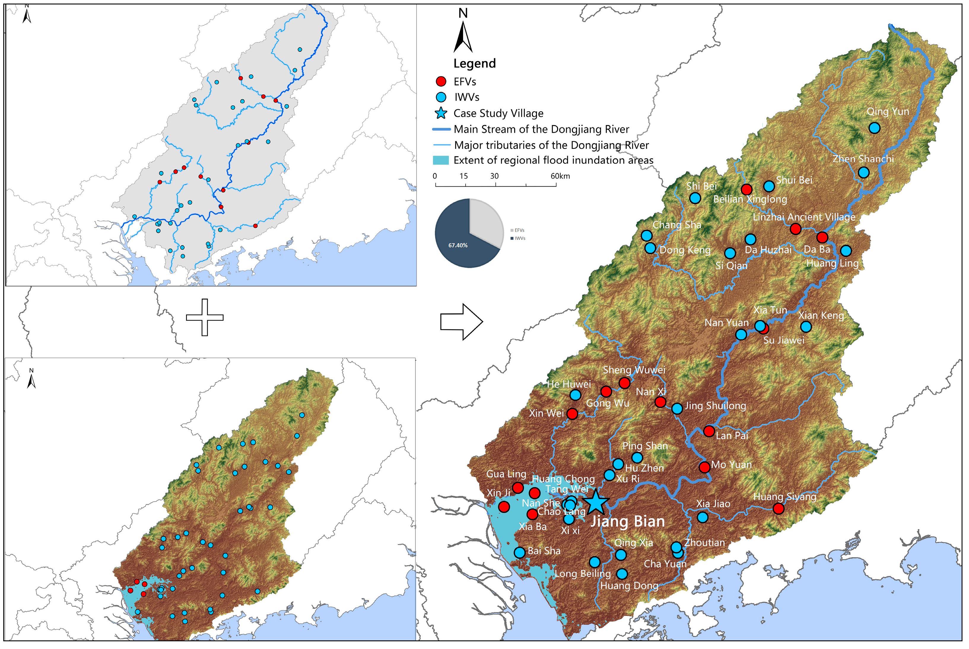
With a total length of 520 km [29], the Dongjiang River has a watershed covering approximately 35,340 square kilometers. As of 2023, a total of 44 villages within the Dongjiang River Basin had been included in the national and provincial registers of traditional villages (Table 1).
Given the diversity of hydrological conditions across different geographical settings, flood hazards are generally associated with fluvial flooding, pluvial flooding, and compound flooding [30]. Based on this hydrological framework, together with an overlay analysis of regional flood-risk zones and river buffer zones, traditional villages in the Dongjiang River Basin were classified into two flood-vulnerability categories: external flood-prone villages (EFV), which are primarily exposed to riverine flooding, and internal waterlogging-prone villages (IWV), which are mainly affected by local rainfall-runoff accumulation. Notably, 67.4% of these settlements were identified as being predominantly vulnerable to pluvial runoff (Figure 1).
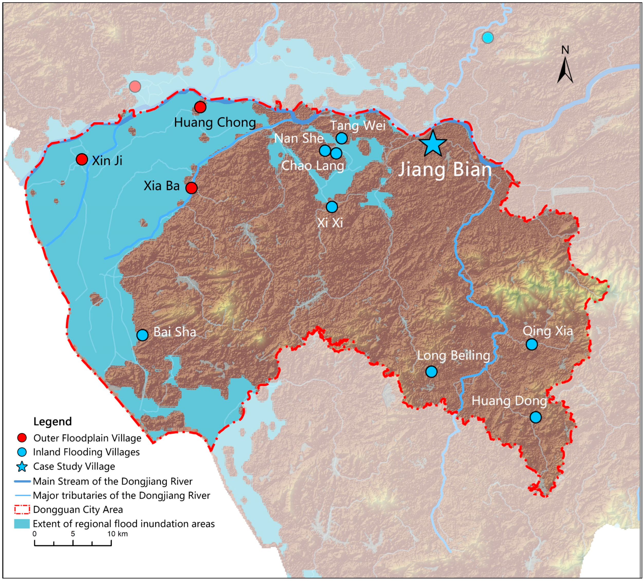
Among the 12 traditional villages in Dongguan, nine are located in flood-prone areas primarily threatened by fluvial flooding, while the remaining three are mainly susceptible to pluvial stormwater runoff (Figure 2). Jiangbian Village is a representative example of an IWV. Located in central Qishi Town, Dongguan, the village has a history dating back to the Yuan Dynasty (1308–1312 AD). It has preserved the traditional spatial layout and cultural landscape of a typical Cantonese village. The village’s drainage and water-storage facilities remain largely intact and functional, making it an ideal case for investigating the operational mechanisms of traditional water management systems in practice. Moreover, the pronounced topographic variations within the village, together with the corresponding organization of its street and alley network, create distinctive spatial characteristics. These features provide a valuable opportunity to examine how Cantonese villages adapt to stormwater runoff and flood risks under complex terrain conditions, thereby making Jiangbian Village a particularly significant case study.

3. Planning and Layout Characteristics of Jiangbian Villages

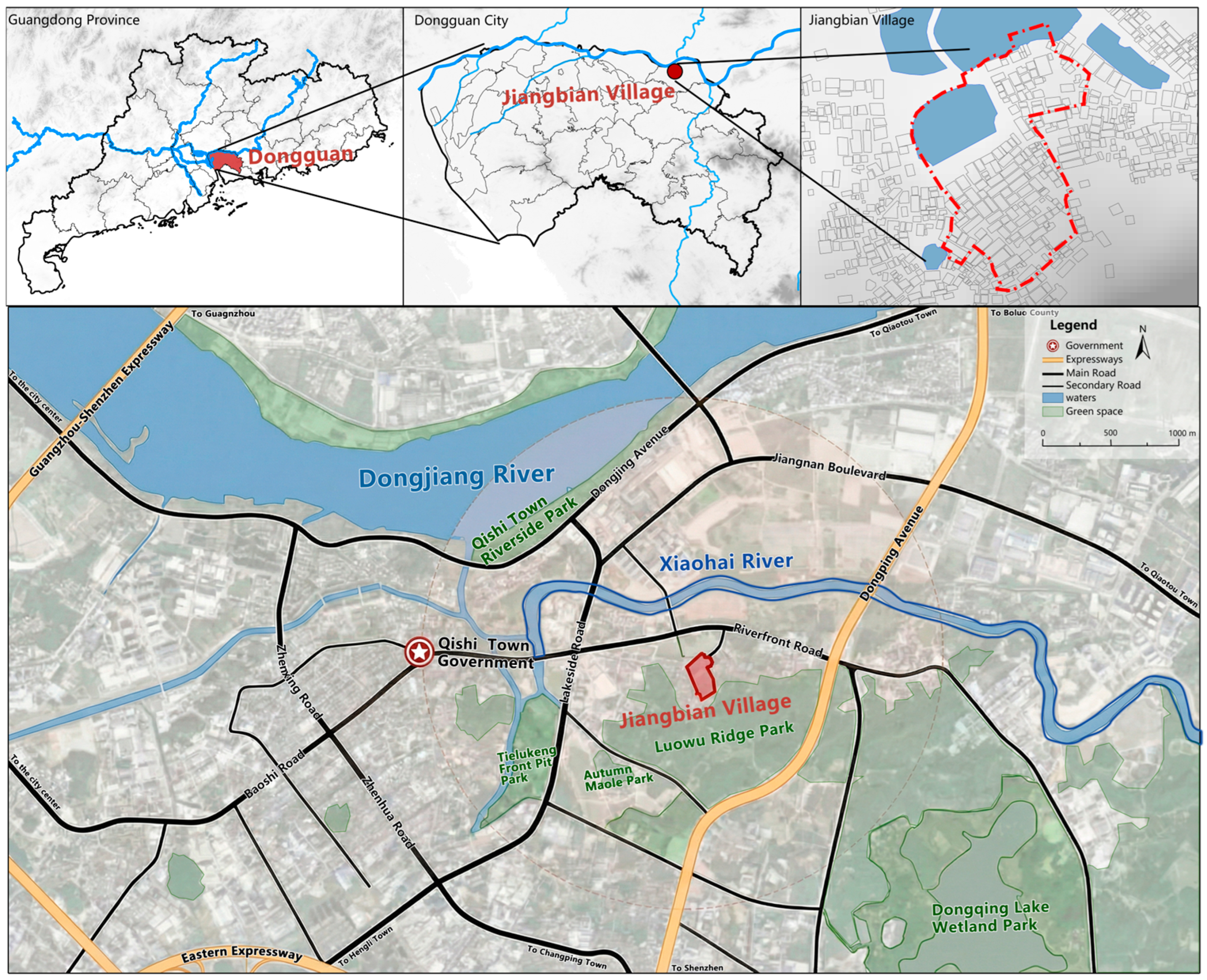
Jiangbian Village is located in the central part of Qishi Town, Dongguan, Guangdong Province, approximately 30.2 km from downtown Dongguan. The village is situated about 1.7 km north of the main channel of the Dongjiang River. The settlement follows a south-to-north spatial configuration, backed by Luowu Ridge to the south and bordered by the Xiaohai River to the north, a terminal tributary in the lower reaches of the Dongjiang River. These geographical conditions provide the village with a favorable microclimate and a well-developed natural ecological foundation (Figure 3).

3.1. Overall Layout in Harmony with the Terrain

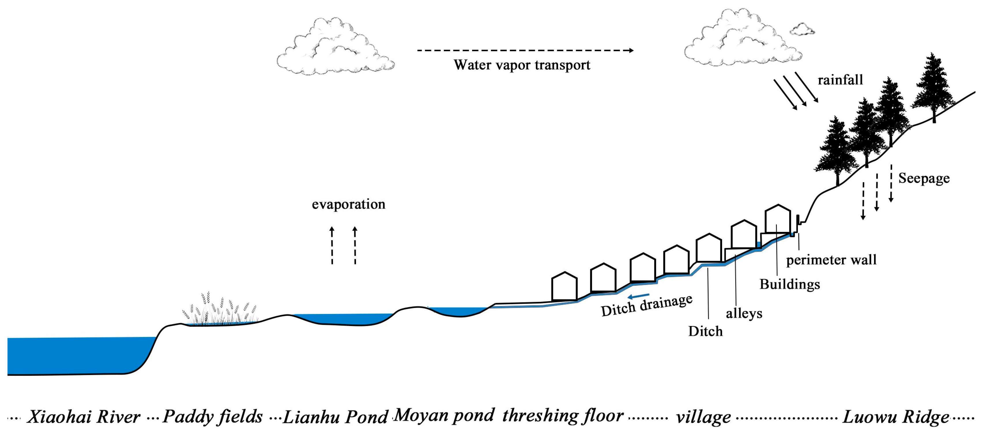
Jiangbian Village is composed of a central built-up area and landscape zones located in front and behind the settlement. The front landscape zone contains functional elements such as threshing floors, ponds, and paddy fields, whereas the rear landscape zone consists of natural hills and woodland extending beyond the village perimeter walls. Moyan Pond serves as the village’s fengshui pond—a traditional pond located in front of ancestral halls or settlements that functions in water storage and regulation. It is connected to the built-up area by a broad threshing floor. To the north of the village are three interconnected ponds—Moyan Pond, Long Pond, and Lianhu Pond—surrounded by several smaller ponds. Together, these water bodies form the primary aquatic landscape and constitute an essential component of the village’s traditional water management system (Figure 4).
The built-up area is situated on the gentle northern slope of Luowu Ridge, with an average elevation of approximately 15.5 m and a maximum elevation difference of 12.2 m (Figure 5a), making it a representative example of a traditional hillside village. In terms of land use, the interconnected ponds and paddy fields located in front of the village constitute the dominant portion of the catchment area, covering a total area of 181,537 square meters. The ponds serve as the core water storage and regulation facilities within the system, with a maximum water depth of 3.7 m. The northern section of the catchment is occupied by paddy fields adjacent to the Xiaohai River, providing a direct and efficient pathway for stormwater discharge (Figure 5b).

3.2. Flood Control and Water Storage System and Its Components

3.2.1. Drainage System

DEM-based hydrological analysis indicates that surface runoff from the northern slope of Luowu Ridge is primarily concentrated along the valley between the two mountain peaks. A limited amount of runoff originating from the hillside south of the village’s built-up area may converge within the settlement and potentially cause pluvial flooding (Figure 6a). Field investigations revealed the presence of a retaining wall approximately 240 mm thick and an interception channel about 200 mm wide between the built-up area and the adjacent hillside. These structures effectively intercept surface runoff and divert it toward the western valley, where the flow ultimately discharges into a pond located at the valley bottom (Figure 6b). In addition, a secondary channel situated between the retaining wall and the village buildings serves as an additional flood-control barrier, further enhancing the village’s stormwater management capacity.
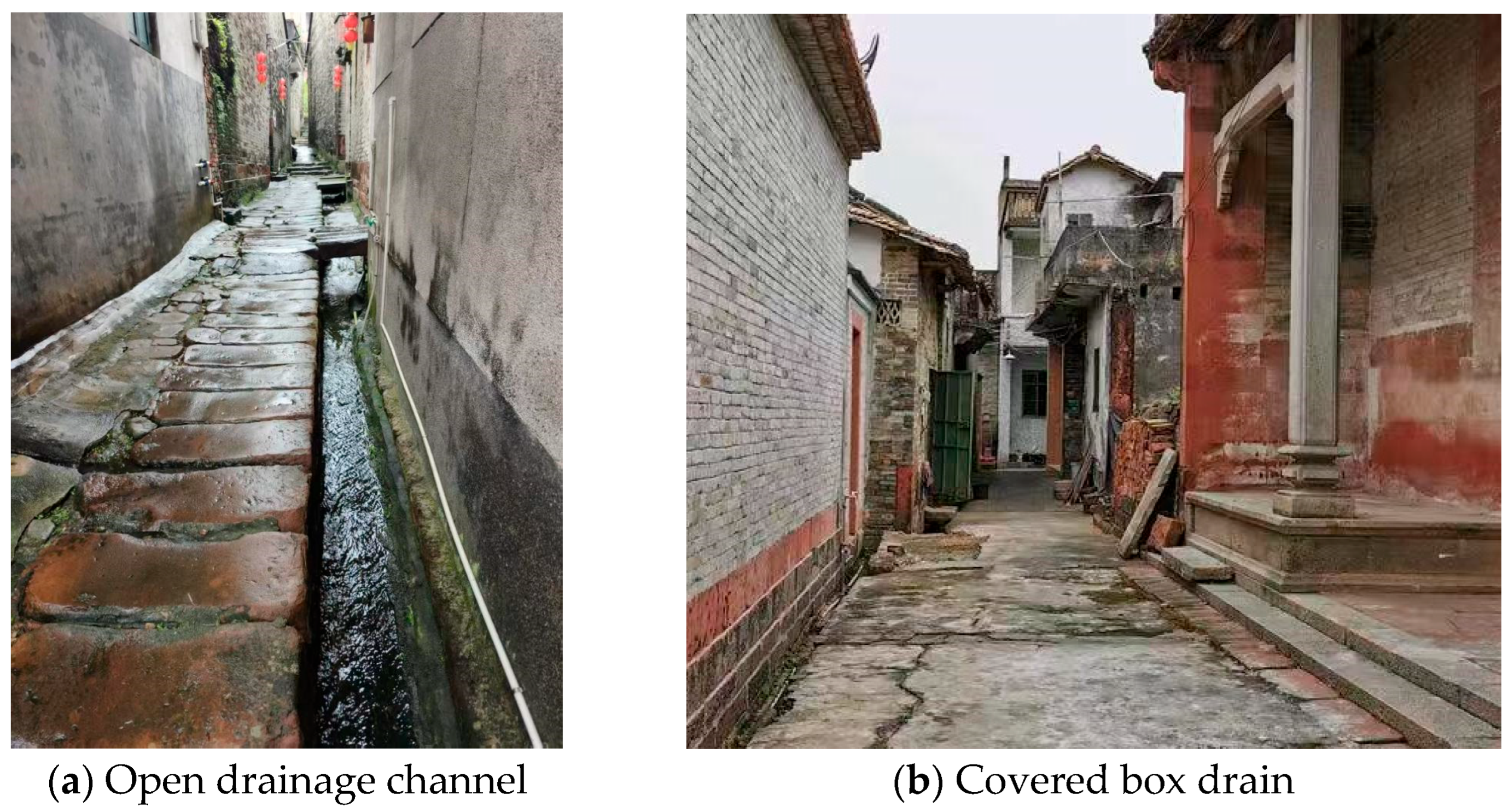
The village drainage system is primarily composed of alleyways and channels. At the building scale, roof runoff is first directed into internal courtyards and then conveyed through subsurface conduits to the main channels along the alleyways. These drainage facilities are predominantly open channels located on both sides of the streets and alleys, supplemented by a small number of covered box drains (Figure 7). Most surface runoff is directed into the channels by the transverse slope of the paved surfaces, while a smaller proportion infiltrates through the joints between the stone paving slabs. This integrated drainage arrangement facilitates the efficient collection and conveyance of stormwater throughout the village.
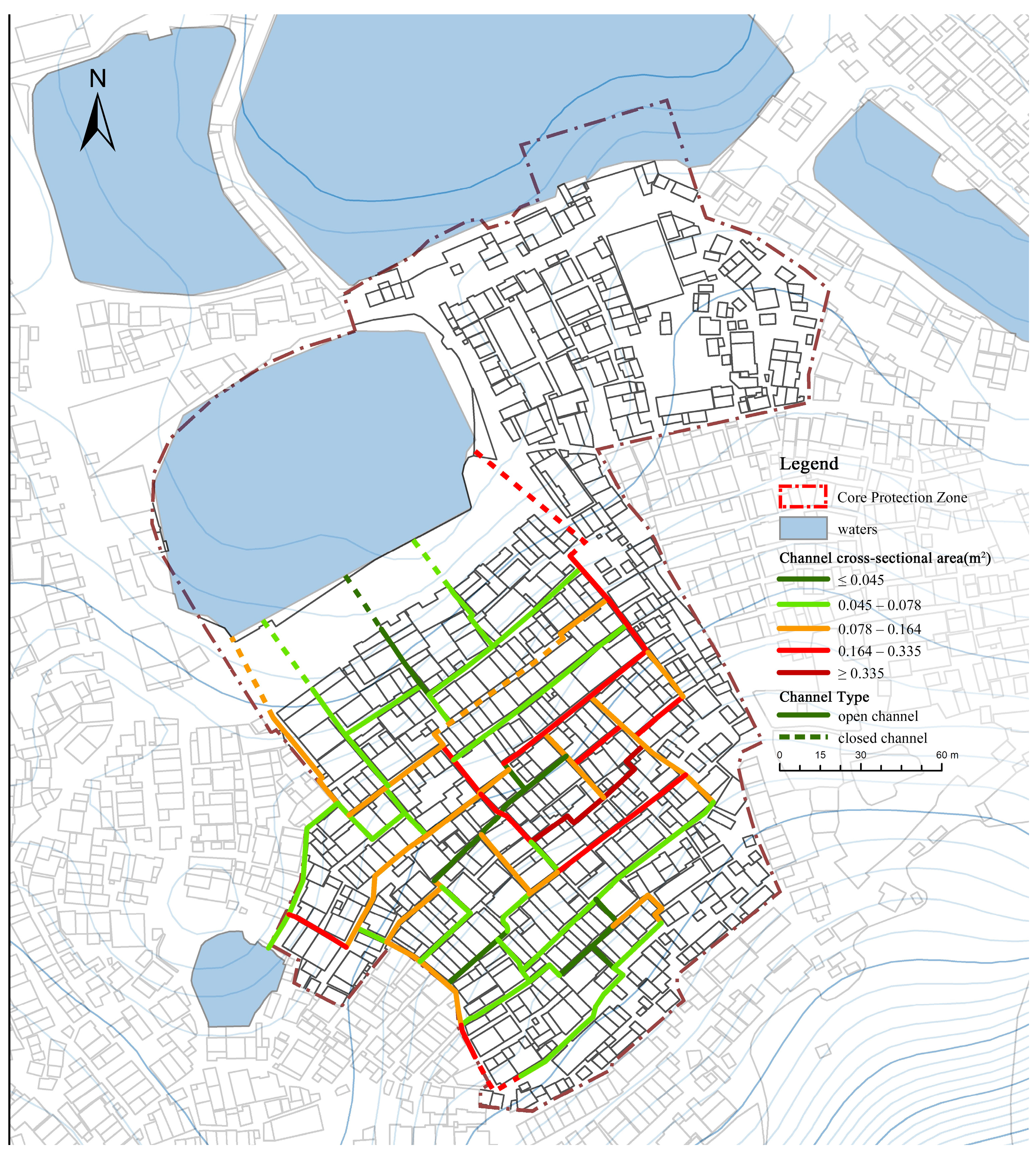
Consistent with the local topography, the built-up area is organized around three longitudinal (north-south) alleys and fifteen transverse (east-west) cross streets. Among these, the longitudinal channels located along the eastern and western edges of the settlement serve as the primary drainage corridors. Positioned at relatively low elevations, these channels facilitate the rapid conveyance and discharge of stormwater runoff. The transverse drainage channels are densely distributed and generally aligned parallel to the topographic contours, representing a distinctive variation in the conventional comb-like settlement pattern commonly found in traditional villages. This dense transverse network intersects with the longitudinal drainage corridors, enabling coordinated runoff conveyance and short-term water retention, thereby forming an integrated and highly efficient drainage and storage system. In addition, the cross-sectional area of the channels exhibits a positive relationship with terrain slope. Field measurements indicate that most channels cross sections range from 0.02 to 0.04 m2 (Figure 8).
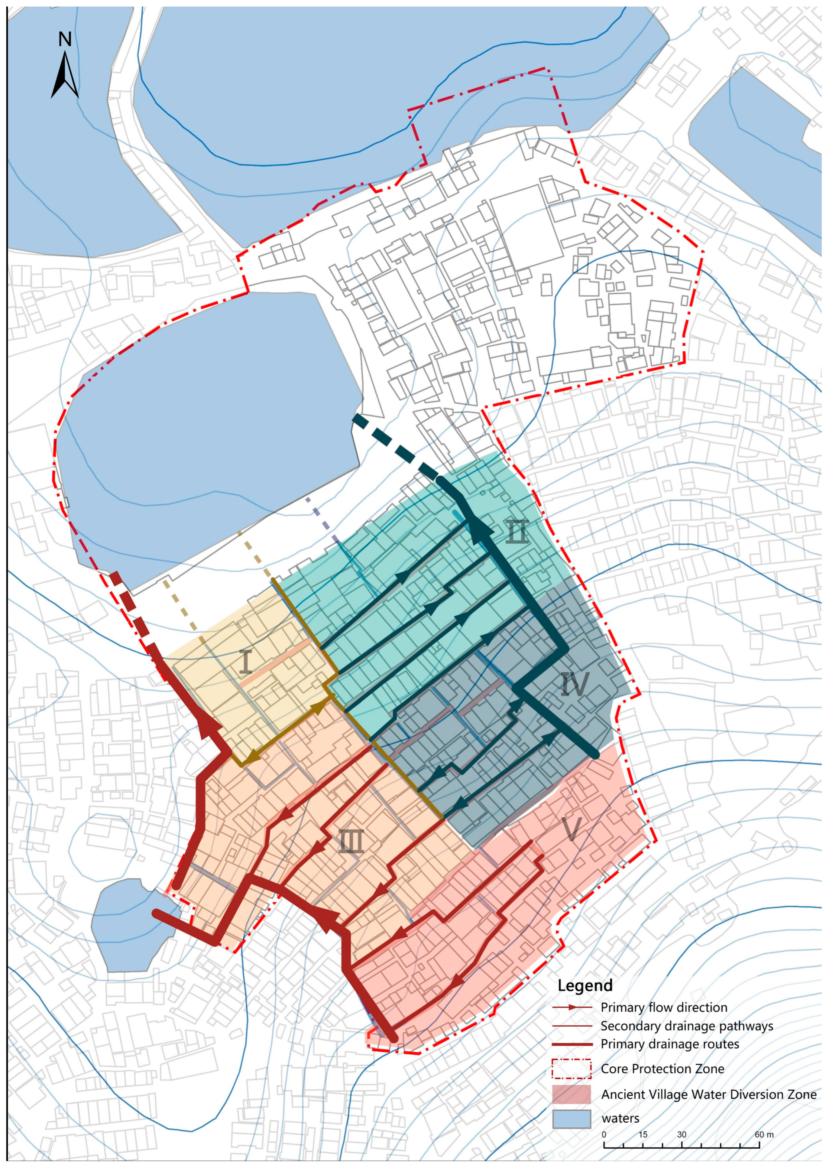
Based on surface runoff flow directions, the built-up area can be divided into five primary drainage catchments (Figure 9). Runoff from Catchments I, III, and V is primarily conveyed through the western main drainage channels, whereas Catchments II and IV are mainly served by the eastern drainage network. Within Catchments I, III, and IV, narrow longitudinal channels are interconnected with transverse drainage channels, allowing stormwater to first flow toward the nearest longitudinal alley before converging into the eastern and western primary drainage corridors. These main drainage channels ultimately discharge into Moyan Pond through subsurface culverts located beneath the threshing floor. This hierarchical drainage configuration enables efficient runoff collection, conveyance, and temporary storage within the village drainage system.
Drainage channels located in relatively flat areas generally adopt square cross-sectional profiles, whereas those situated in zones with pronounced topographic gradients are characterized by narrow and deep cross sections. At intersections between longitudinal and transverse alleys, the channels transition to shallower and wider profiles to facilitate runoff conveyance and flow redistribution. The village layout follows the natural terrain, with building plots arranged along contour lines. In areas of steep slope, terraces are created through cut-and-fill operations, forming a spatial pattern that reflects the principle of “adapting to the terrain and following the slope.” For example, Xingrenli Lane 6 contains a deep trench at the base of a terrace due to the steep local gradient. This design not only improves land-use efficiency but also reduces the erosion risk to building foundations caused by surface runoff. In contrast, open channels in locations such as Xingrenli Lane 4 employ square cross-sectional profiles, creating distinct visual characteristics and reflecting the adaptation of drainage design to local topographic conditions (Table 2).

3.2.2. Storage and Regulation System

The stormwater storage system of Jiangbian Village primarily consists of ponds, paddy fields, and threshing floors. Among these components, ponds perform multiple functions (Figure 10). In addition to supporting aquaculture and fire prevention, they provide substantial water storage capacity and serve as critical nodes within the village’s hydrological system. The inlet of Moyan Pond is connected to three longitudinal drainage channels originating from the built-up area, while its outlet is located on the opposite side of the pond and is linked to adjacent water bodies, including Lianhu Pond. This interconnected pond network provides a high degree of hydraulic redundancy and enhances the overall resilience of the water management system. When external flood peaks from the Xiaohai River coincide with internal waterlogging events, the extensive paddy fields play an important role in intercepting sediment and reducing flow velocity. They also function as temporary retention basins for overflow water from the ponds, forming an integrated flood-storage network. Moreover, the period of highest rainfall in July and August coincides with the peak irrigation demand for rice cultivation, creating a synergistic relationship between agricultural production and water management that contributes to the ecological resilience of the system. The threshing floors, paved with bluestone slabs, facilitate rapid surface runoff conveyance within the ancestral hall precincts surrounding Xingrenli Lane 1. During extreme rainfall events, these open spaces can also serve as localized temporary detention areas, further enhancing the village’s stormwater storage and flood mitigation capacity.

4. Effectiveness Analysis of the Drainage and Storage System in Jiangbian Village

4.1. Materials and Methods

Based on the characteristics of the stormwater drainage and retention system in Jiangbian Village, quantitative rainfall simulations were conducted using GIS (Arcmap 10.5) and SWMM (SWMM 5.0). First, changes in total runoff volume, peak discharge, and storage capacity were evaluated under rainfall events with different return periods. Subsequently, runoff control performance was analyzed under various design scenarios to assess the overall effectiveness of key drainage and storage components, including channels, paddy fields, ponds, and threshing floors. Finally, the hydrological functions and operational mechanisms of these components were systematically examined to reveal their respective contributions to the village’s stormwater resilience.

4.1.1. Drainage System Generalization

Because the drainage systems of the surrounding settlement share common water-storage facilities with the core protected area, the study area encompasses both the eastern and western sections of Jiangbian Village. The boundaries are defined by Luowu Ridge to the south, the Xiaohai River to the north, and the surrounding paddy fields. Consequently, all areas hydrologically connected to village runoff are included within the analysis. The total study area covers 116.14 ha.
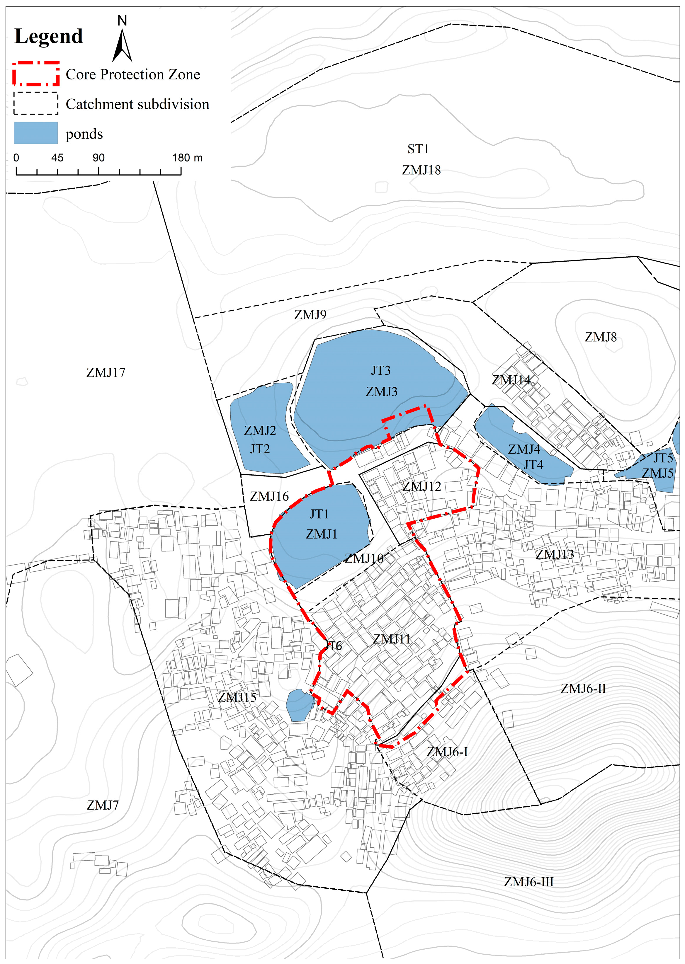
Sub-catchment boundaries were delineated using a 10 m resolution DEM (WGS84 UTM Zone 49N) (Figure 11), supplemented by field surveys and interpretation of aerial imagery. Land-use classification was conducted using high-resolution satellite imagery and subsequently verified through field investigations to ensure classification accuracy.
Based on land use, topography, pond distribution, and hydraulic flow convergence patterns, the study area was subdivided into 18 sub-catchments, including traditional village cores, newly developed residential areas, forested hillslopes, paddy fields, ponds, and threshing floors.
The Horton infiltration model was employed, with parameter values assigned according to land-use type to account for variations in soil properties and surface characteristics across the catchment (Table 3). In particular, portions of sub-catchment ZMJ08 have experienced a higher degree of anthropogenic disturbance, resulting in greater soil compaction than that observed on the slopes of Luowu Ridge.
This study employs SWMM to simulate the hydrological processes of Jiangbian Village and evaluate the performance of its traditional stormwater resilience infrastructure. Six major ponds distributed throughout the village were represented as storage units within the SWMM framework. The storage geometry of each pond was parameterized using the following functional relationship, with model parameters calibrated based on surveyed pond dimensions and field measurements [31].
A = C × d n
where A is the surface area (m2), d is the water depth (m), C is the base area coefficient, and n is the shape exponent.
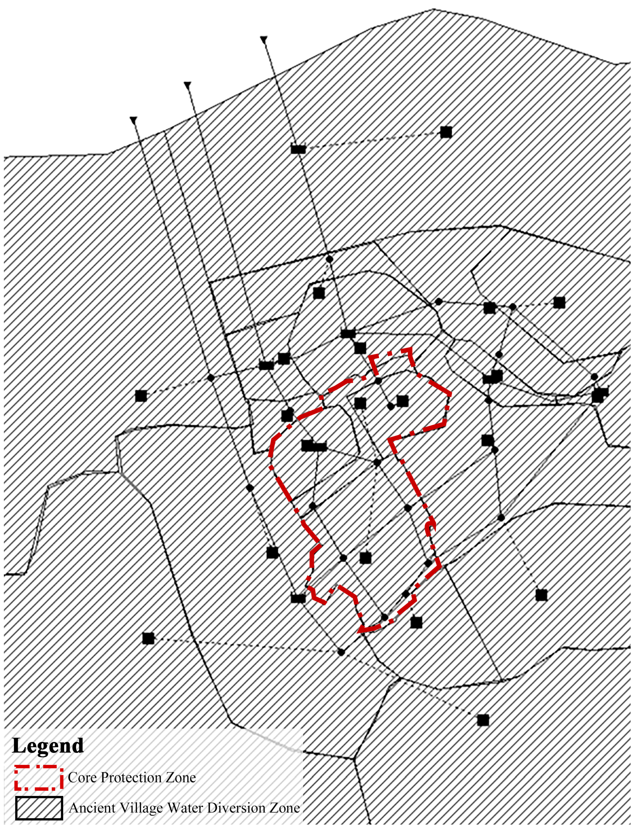
Based on the divided catchment zoning results of Jiangbian Village, the village drainage system schematic diagram was constructed and generalized into the SWMM model network (Figure 12). Due to their substantial water retention capacity and relatively stable infiltration characteristics, paddy fields were generalized as shallow storage units within the SWMM [32]. A maximum storage depth of 0.55 m was assigned to represent the height of the paddy field bunds, based on field measurements of representative bund profiles. The storage capacity of the threshing floors was defined by the depression storage depth of their corresponding sub-catchments. Geometric parameters of the drainage channels, including channel width and depth, were assigned according to field-measured data.

4.1.2. Parameter Settings

Parameters expressed as ranges were assigned according to land-use categories (Table 3), based on field surveys and a review of relevant literature. All other parameters were applied uniformly across the sub-catchments. The sources of individual parameter values are documented in Table 4, with each parameter value referenced to the corresponding SWMM manual, technical standard, or published study from which it was derived, thereby ensuring model transparency and reproducibility. The initial (baseline) values refer to the parameter settings prior to land-use differentiation.
A global one-at-a-time (OAT) sensitivity analysis was performed, whereby each parameter was perturbed simultaneously across all applicable sub-catchments. Perturbation levels of ±10%, ±20%, and ±30% relative to the baseline values were applied to each of the eleven selected parameters [35].
The sensitivity index (SI) was calculated as:
S I = ( Δ Y / Y 0 ) / ( Δ X / X 0 )
where ΔY is the change in output metric, Y0 is the baseline output, ΔX is the parameter perturbation, and X0 is the baseline parameter value.
The sensitivity analysis results, as shown in Table 5, indicate that the minimum infiltration rate (SI = −0.176), imperviousness (SI = 0.113), and Manning’s roughness coefficient for pervious surfaces (SI = −0.109) are moderately sensitive parameters. In contrast, slope (SI = 0.056), depression storage on pervious surfaces (SI = 0.035), and the Horton decay constant (SI = 0.028) exhibit low sensitivity. The remaining four parameters are considered insensitive, with sensitivity index (SI) values below 0.002.
Among the three moderately sensitive parameters, imperviousness was derived directly from remote sensing interpretation and field surveys and is therefore considered highly reliable. Consequently, uncertainty analysis was performed only for the other two moderately sensitive parameters. The results indicate that, under the co pond-failure scenario, the peak water depth at node J14 increases by 20.8–23.8% across all nine parameter combinations relative to the intact-condition scenario. The maximum deviation from the baseline simulation results is only 2.7 percentage points. Furthermore, following pond failure, the number of flooded nodes ranges from 7 to 8 across all parameter sets and rainfall return periods (Table 6). In contrast, under intact conditions, the number of flooded nodes remains between 0 and 1 regardless of the parameter set applied.
The direction and magnitude of the effects associated with pond failure remain consistent across the entire parameter space examined. These findings demonstrate that the identification of pond infrastructure as a critical hydraulic component, as well as the quantitative estimation of its contribution to flood attenuation, are robust and not significantly affected by uncertainties in the minimum infiltration rate or Manning’s roughness coefficient for overland flow. Within the tested parameter ranges, the model exhibits low sensitivity to variations in these parameters.

4.1.3. Extreme Rainfall Simulation

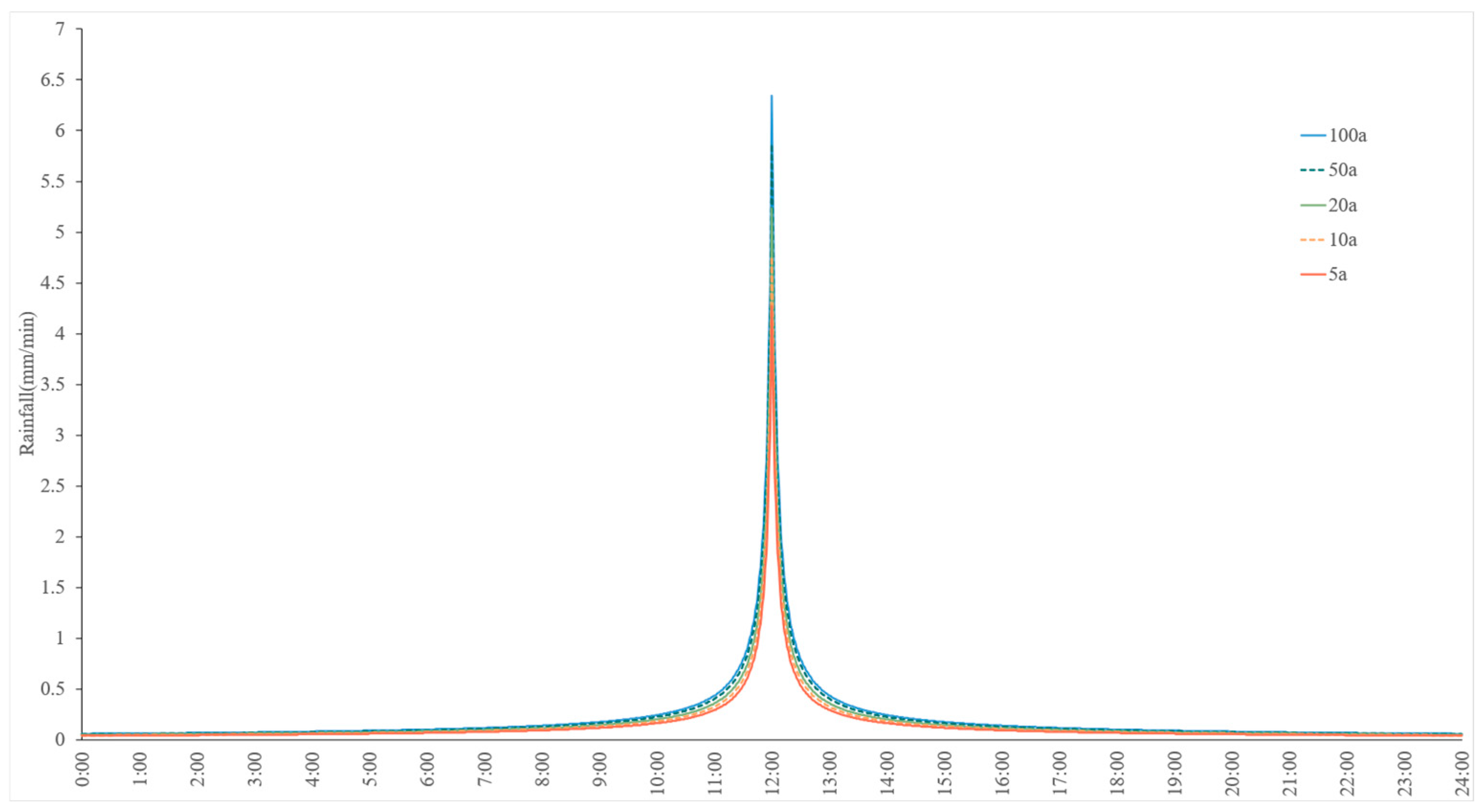
For the flow-routing process, the dynamic wave method was employed to solve the Saint-Venant equations. Precipitation serves as the primary input variable for the SWMM. Because storm events in China are predominantly characterized by a single-peaked rainfall pattern, the Chicago hyetograph was adopted to represent the temporal distribution of rainfall intensity. The rainfall intensity was calculated using the following storm intensity equation [36]:
q = 3717.342 1 + 0.503 log P t + 14.533 0.729
where q is the storm intensity (mm/h); t is the storm duration (h); P is the return period (years).
This study assumes spatially uniform precipitation within each sub-catchment and employs a nonlinear reservoir model to simulate surface runoff generation. Design rainfall events were derived using the intensity–duration–frequency (IDF) relationship developed for Dongguan City. A storm duration of 24 h st was adopted with a temporal resolution of 5 min, and a symmetric rainfall distribution with a peak position coefficient of 0.5 was applied. Based on these settings, the total rainfall depths corresponding to the 5-, 10-, 20-, 50-, and 100-year return periods were calculated as 214.52 mm, 238.55 mm, 262.59 mm, 294.35 mm, and 318.39 mm, respectively (Figure 13).

4.1.4. Simulated Scenario

Based on the structural characteristics of J, the drainage and retention system in Jiangbian Village and the dominant flood-generating mechanisms affecting traditional settlements in Dongguan, four simulation scenarios were established. These scenarios were designed to reproduce the impacts of functional failure in key stormwater management components—including ponds, channels, paddy fields, and threshing floors—on surface runoff processes and water retention performance. To quantify the hydrological contribution of each traditional water infrastructure element, a progressive failure framework was developed, incorporating five levels of functional degradation: 0%, 25%, 50%, 75%, and 100% (Table 7).

4.1.5. Simulation of Runoff from the Enclosure and Luowu Ridge

Previous hydrological analyses identified runoff from Luowu Ridge as an important factor influencing the overall hydrological regime of the study area. However, its direct impact on the traditional village is relatively limited for two main reasons. First, owing to the natural topography, most runoff generated on Luowu Ridge is conveyed through the valley between the two mountain peaks, with only a small portion flowing toward the traditional village area. Second, field investigations revealed that the village perimeter wall, when intact, effectively intercepts runoff from the adjacent hillslope. A drainage channel located outside the wall, together with a secondary channel positioned between the wall and the building edge, captures and redirects hillside runoff before it can enter the settlement. Because SWMM does not explicitly simulate the runoff-blocking function of walls, the exclusion of Luowu Ridge runoff from the wall-intact baseline scenario was based on field observations and hydrological interpretation. Under this baseline condition, runoff from Luowu Ridge is assumed to follow its natural topographic pathways and existing drainage channels without directly entering the traditional village area. All subsequent failure scenarios were developed using this baseline configuration as the reference boundary condition.
To evaluate the potential consequences of retaining-wall failure under extreme rainfall conditions, an additional scenario representing complete wall failure was established. In this scenario, all runoff originating from Luowu Ridge was incorporated into the village catchment, representing the upper-bound hydrological condition used for sensitivity analysis. Intermediate scenarios corresponding to 25%, 50%, and 75% wall failure were not considered in this study. This is because the actual volume of runoff entering the village following partial wall collapse is strongly influenced by stochastic factors, including the location, extent, and timing of the failure. As a result, the hydrological impacts of partial wall damage cannot be reliably represented using fixed percentages of structural failure. Therefore, comparing the two end-member conditions—complete blockage (intact wall) and complete failure—provides a more robust and defensible framework for assessing the hydrological significance of the retaining wall and the range of potential flood impacts.
The comparison results indicate that when the perimeter wall remains intact, flooding within the village occurs only under the 100-year return period rainfall event, with a maximum water depth of 0.39 m recorded at node J12. Following complete wall failure, the peak water depth at J12 increases substantially across all rainfall return periods. Under the 5-year return period event, the water depth increases from 0.27 m to 0.46 m, representing an increase of approximately 70%. Under the 100-year return period event, the peak water depth rises from 0.39 m to 0.67 m, corresponding to an increase of approximately 72%. Moreover, the flooding threshold shifts markedly following wall failure, decreasing from a 100-year return period under intact conditions to approximately a 50-year return period. These findings demonstrate that the perimeter wall functions as a critical external protective boundary for the traditional village. Its failure substantially reduces the rainfall threshold required to trigger flooding and significantly increases flood severity. Therefore, the perimeter wall represents a key structural element influencing the stormwater resilience of traditional villages.

4.2. Stormwater Simulation Experiment

4.2.1. Control Group Experimental Results

The preceding analysis indicates that Jiangbian Village effectively utilizes its pronounced topographic relief to facilitate rapid gravity-driven drainage. As long as the low-lying ponds do not exceed their storage capacities, the traditional residential core, located at a relatively higher elevation, remains largely protected from flood inundation [26]. SWMM simulations were conducted under rainfall events with different return periods. The results in Table 8 show that, for rainfall events below the 100-year return period, all ponds remained within their storage capacities, and no node flooding occurred at any drainage node within the built-up area. Under the 100-year return period rainfall event, only one pond experienced slight surcharging. The excess water was effectively accommodated by the adjacent threshing floor, preventing runoff from entering the residential area. These findings are consistent with historical records indicating that flooding has been rare in Jiangbian Village and demonstrate the high effectiveness of its traditional stormwater drainage and storage system.

4.2.2. Scenario 1 (Pond Failure) Experimental Results

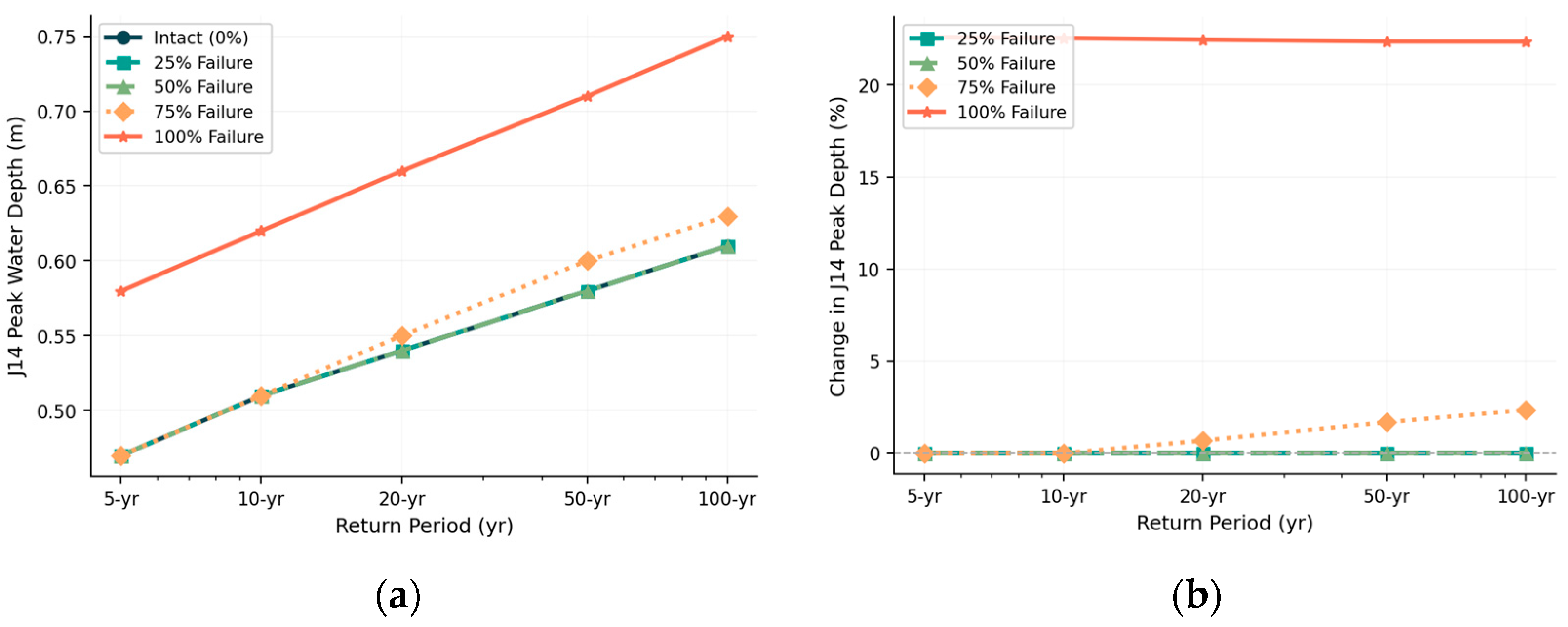
Under intact conditions, the peak water depth at node J14 increases from 0.47 m under the 5-year return period rainfall event to 0.61 m under the 100-year return period event. This progressive increase reflects the greater hydraulic loading imposed on the drainage system as rainfall intensity increases. Although pond failure does not alter this overall trend, it significantly amplifies the magnitude of peak water depths across all return periods. At the 25% and 50% failure levels, the peak water depth at J14 remains relatively close to that under intact conditions. However, at the 75% failure level, a notable increase becomes evident, particularly under the 50-year and 100-year return period rainfall events. Under the complete pond-failure scenario, the peak water depth at J14 increases by approximately 22% across all return periods (Figure 14).
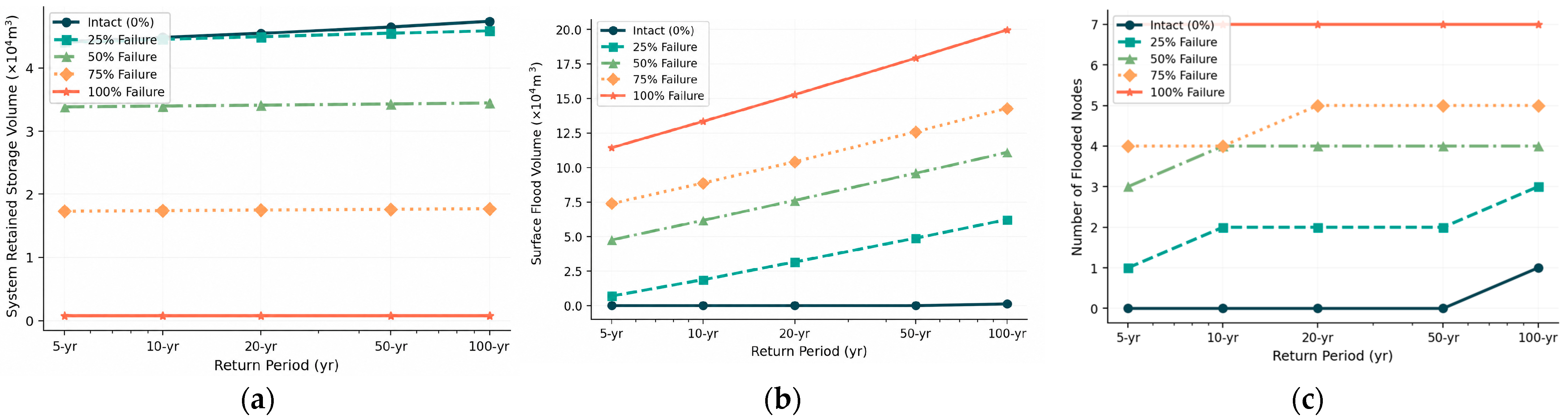
The most pronounced impact of pond failure is the substantial loss of system storage capacity (Figure 15). Under intact conditions, the drainage and retention system stores approximately 4.4 × 10⁴ to 4.7 × 10⁴ m3 of water across all rainfall return periods. At the 25% pond-failure level, the system reaches its maximum storage capacity under all return periods. This represents a critical threshold in system performance: once the system becomes fully saturated, any additional inflow can no longer be accommodated within the storage network. At the 50% failure level, the retained storage volume decreases to approximately 3.4 × 10⁴ m3. Under the complete pond-failure scenario, storage capacity declines dramatically to approximately 900 m3, representing a reduction of approximately 98% compared with the intact condition. As a result, water that can no longer be retained within the pond system is directly converted into surface flooding. Consequently, the surface flood volume increases from nearly zero under intact conditions to 1.15 × 10⁵ m3 under the 5-year return period rainfall event and to 2 × 10⁵ m3 under the 100-year return period event when complete pond failure occurs. Simultaneously, the number of flooded nodes remains at seven under all rainfall return periods when complete pond failure occurs.

4.2.3. Scenario 2 (Channel Failure) Experimental Results

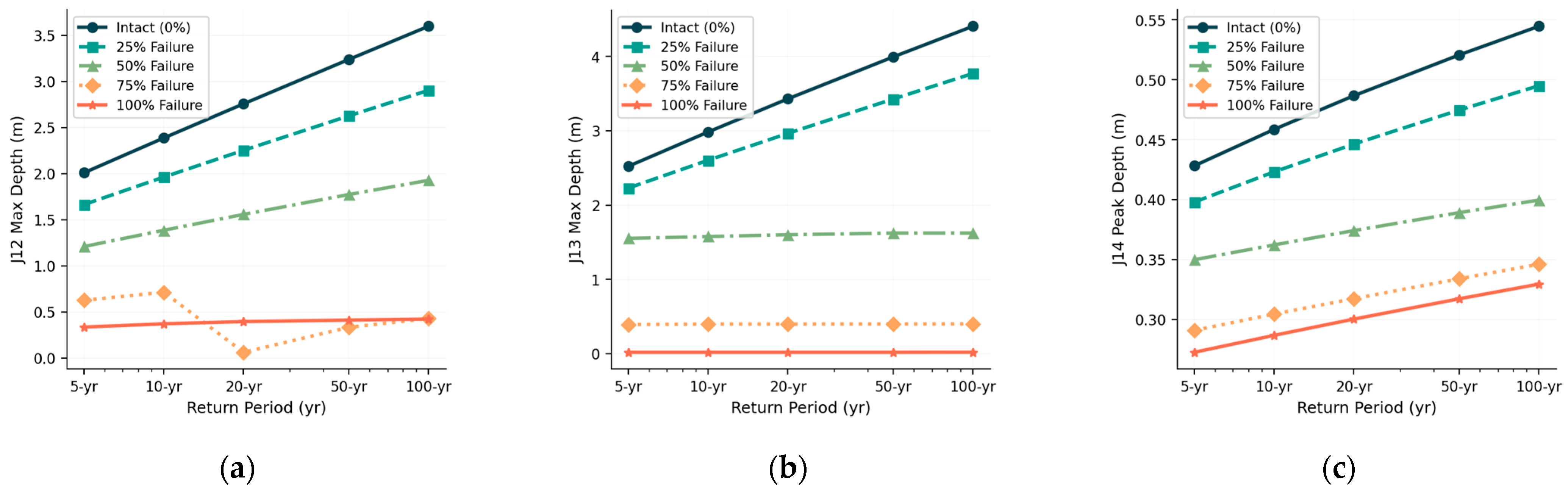
Under intact conditions, the peak water depth at node J12 ranges from 2.01 m under the 5-year return period rainfall event to 3.60 m under the 100-year return period event. As the level of channel failure increases, the peak water depth at J12 initially rises substantially, reaching a maximum value of 4.01 m under the 75% failure scenario during the 100-year storm. This represents an increase of approximately 11.5% compared with the intact condition. This increase occurs because partial blockage of the drainage channels restricts flow conveyance, causing water to accumulate at the upstream entrance of the village before being redirected through alternative pathways. However, under the complete channel-failure scenario, the peak water depth at J12 decreases to 3.60 m, slightly lower than that observed under intact conditions. This non-monotonic response reflects a threshold effect within the drainage system. Once the channels become fully blocked, runoff can no longer be conveyed through the original drainage network and is instead redistributed via overland flow pathways. As a result, less water accumulates at node J12, reducing the local water depth recorded at that location, even though flooding conditions become more severe elsewhere in the system.
Nodes J13 and J14 exhibit the opposite response pattern. Under intact conditions, the peak water depth at J13 reaches 4.41 m during the 100-year return period rainfall event. Under the complete channel-failure scenario, this value decreases dramatically to only 0.02 m, representing a reduction of more than 99%. Similarly, the peak water depth at J14 decreases from 0.545 m to 0.330 m, corresponding to a reduction of 39.5%. However, these reductions should not be interpreted as an improvement in drainage performance. Instead, they reflect a fundamental redistribution of runoff pathways within the system. When the drainage channels fail, water that would normally be conveyed through the drainage network toward nodes J13 and J14 is no longer able to reach these locations (Figure 16).
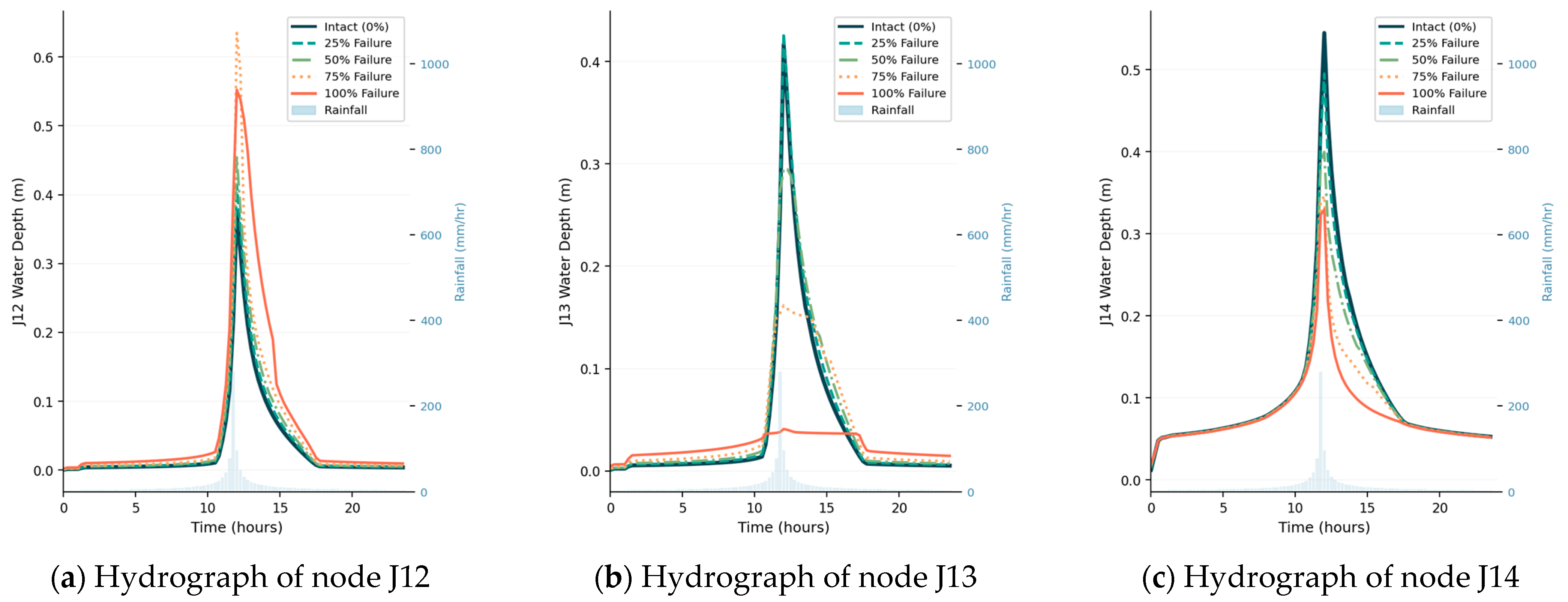
The hydrographs for the 100-year return period rainfall event clearly illustrate this phenomenon. Under intact conditions, node J13 exhibits a pronounced and sharp peak discharge response. As the degree of channel failure increases, this peak progressively diminishes and nearly disappears under the complete failure scenario. A similar pattern is observed at node J14, where both the peak magnitude and overall hydrograph response decrease with increasing channel failure (Figure 17).
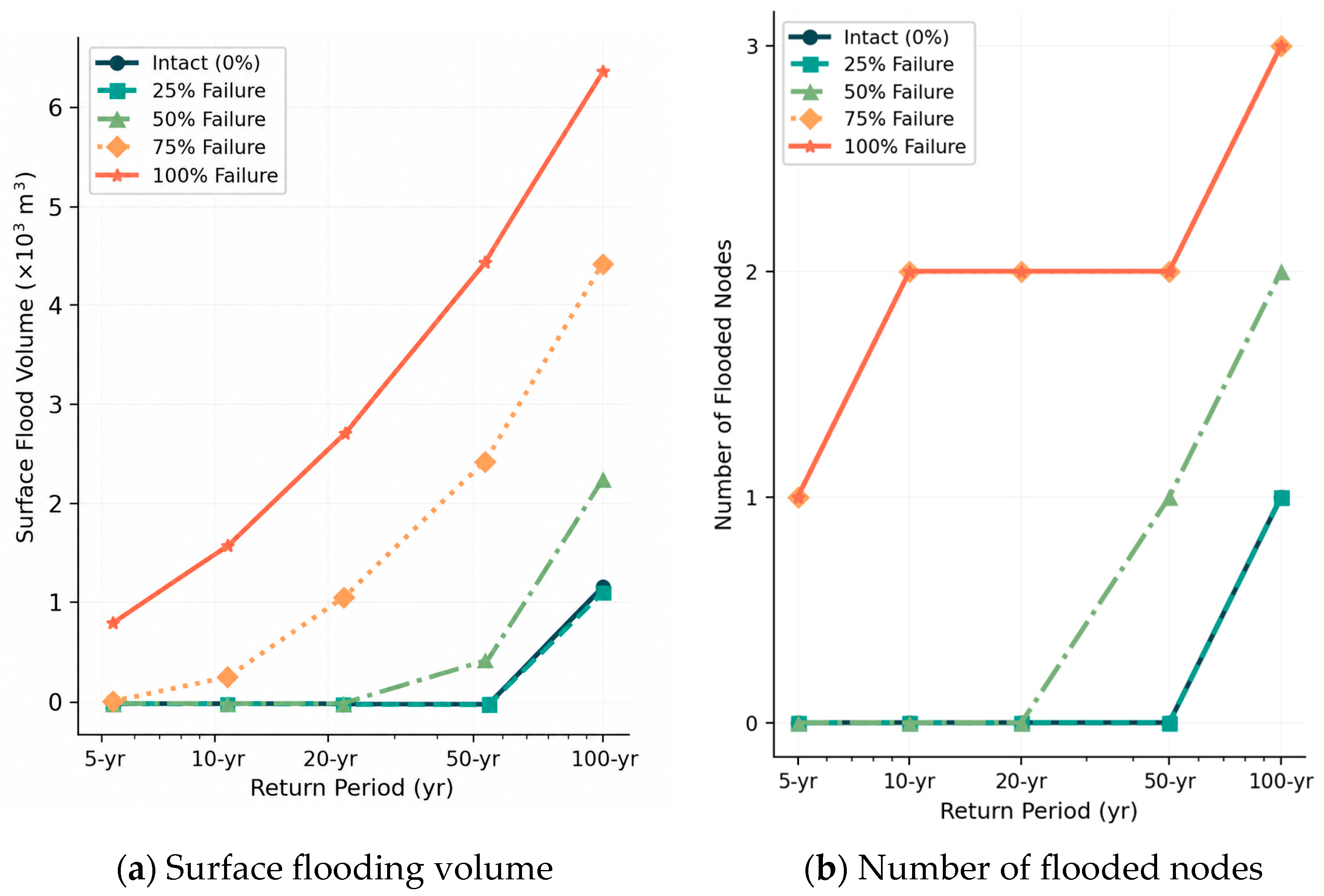
Under intact conditions and the 25% channel-failure scenario, no surface flooding occurs for rainfall events with return periods of up to 50 years. At the 50% failure level, surface flooding begins to occur under the 50-year and 100-year return period events (Figure 18). Under the complete channel-failure scenario, the number of flooded nodes increases to three during the 100-year storm, and the total surface flood volume reaches 6300 m3. These values reflect the hydraulic redistribution mechanism described above. The simulated flood volume primarily represents water accumulating at upstream locations due to impaired conveyance, rather than water being effectively transported through the drainage network.

4.2.4. Scenario 3 (Paddy Fields Failure) Experimental Results

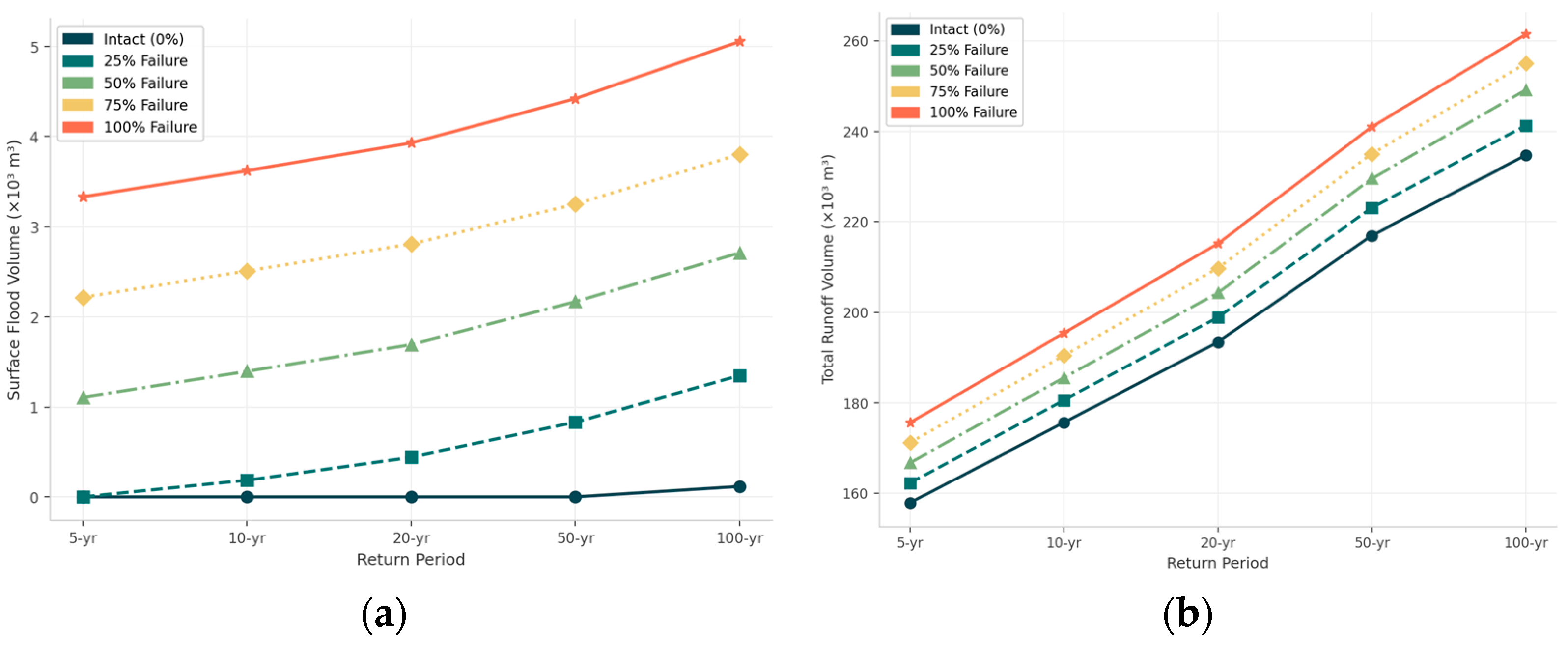
Under intact conditions, no surface flooding occurs for rainfall events with return periods of up to 50 years, and only 117 m3 of flood volume is recorded during the 100-year return period event. Under the complete paddy field failure scenario, however, flood volumes increase substantially, reaching 3.331 × 10³ m3 under the 5-year return period event and 5.054 × 10³ m3 under the 100-year return period event. Under the latter condition, the flood volume is approximately 43 times greater than that observed under intact conditions (Figure 19a). A similar trend is observed for total runoff volume. Under the 100-year return period event, runoff increases from 234.744 × 10³ m3 under intact conditions to 261.454 × 10³ m3 under complete failure, representing an increase of 11.4%. More notably, under the 5-year return period event, runoff increases by 11.2% following complete failure. This similarity in relative change across different storm magnitudes indicates that paddy fields provide a relatively consistent runoff retention function over a wide range of rainfall intensities (Figure 19b).

4.2.5. Scenario 4 (Threshing Floor Failure) Experimental Results

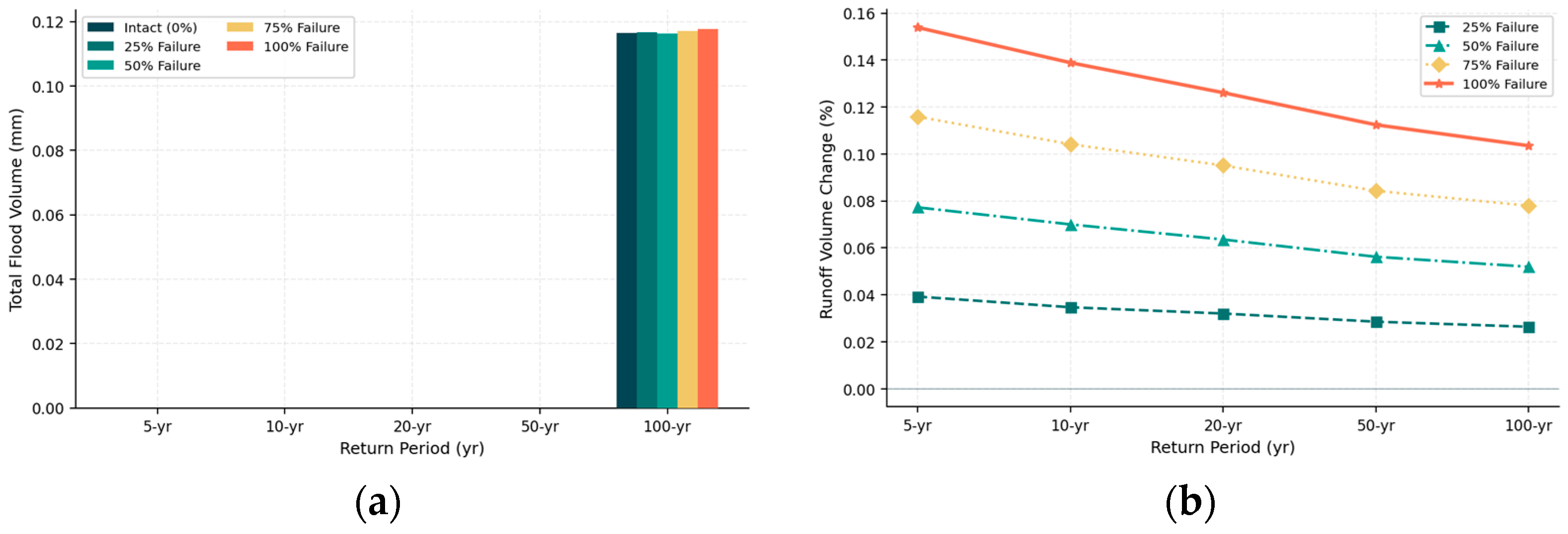
No flooding was observed under the 5-, 10-, 20-, or 50-year return period rainfall events in any of the simulated scenarios (Figure 20). Under the 100-year return period event, the total system flood volume increased only marginally, from 0.1165 mm under intact conditions to 0.1177 mm under the complete failure scenario, representing a difference of 0.0012 mm. Because SWMM still categorizes this volume as system outflow, the numerical differences among the scenarios are statistically insignificant. From a spatial planning perspective, the threshing floors function as an important horizontal buffer within the village’s stormwater management system. By increasing the separation distance between ponds and residential areas, these open spaces help dissipate hydraulic energy and reduce the direct pressure exerted by pond overflow on the built environment. Consequently, threshing floors contribute to flood mitigation by providing temporary storage and buffering capacity, thereby enhancing the protection of residential areas from flood impacts.

4.3. Cultural Landscape Characteristics of Jiangbian Villages Based on Stormwater Resilience

4.3.1. Landscape Characteristics Based on Engineering Resilience

The simulation results indicate that Jiangbian Village remains resilient to flooding even under a 100-year return period storm event. At peak conditions, the runoff volume occupies only approximately 70% of the system’s total storage capacity, demonstrating the exceptional hydrological robustness of the traditional drainage and retention network. During the centennial storm, only one pond reaches its maximum storage capacity, while Longtan Pond, located farther from the main runoff pathways, utilizes only 18% of its total storage volume. In addition, the threshing floors function as supplementary detention areas, illustrating the principle of hydraulic redundancy within the system. The extensive network of interconnected ponds, together with the threshing floors, forms an integrated and highly resilient water management system capable of effectively storing, regulating, and conveying stormwater. This layout highlights the solemn and majestic character of the ancestral halls along the village’s main frontage.

4.3.2. Landscape Characteristics Based on Ecological Resilience

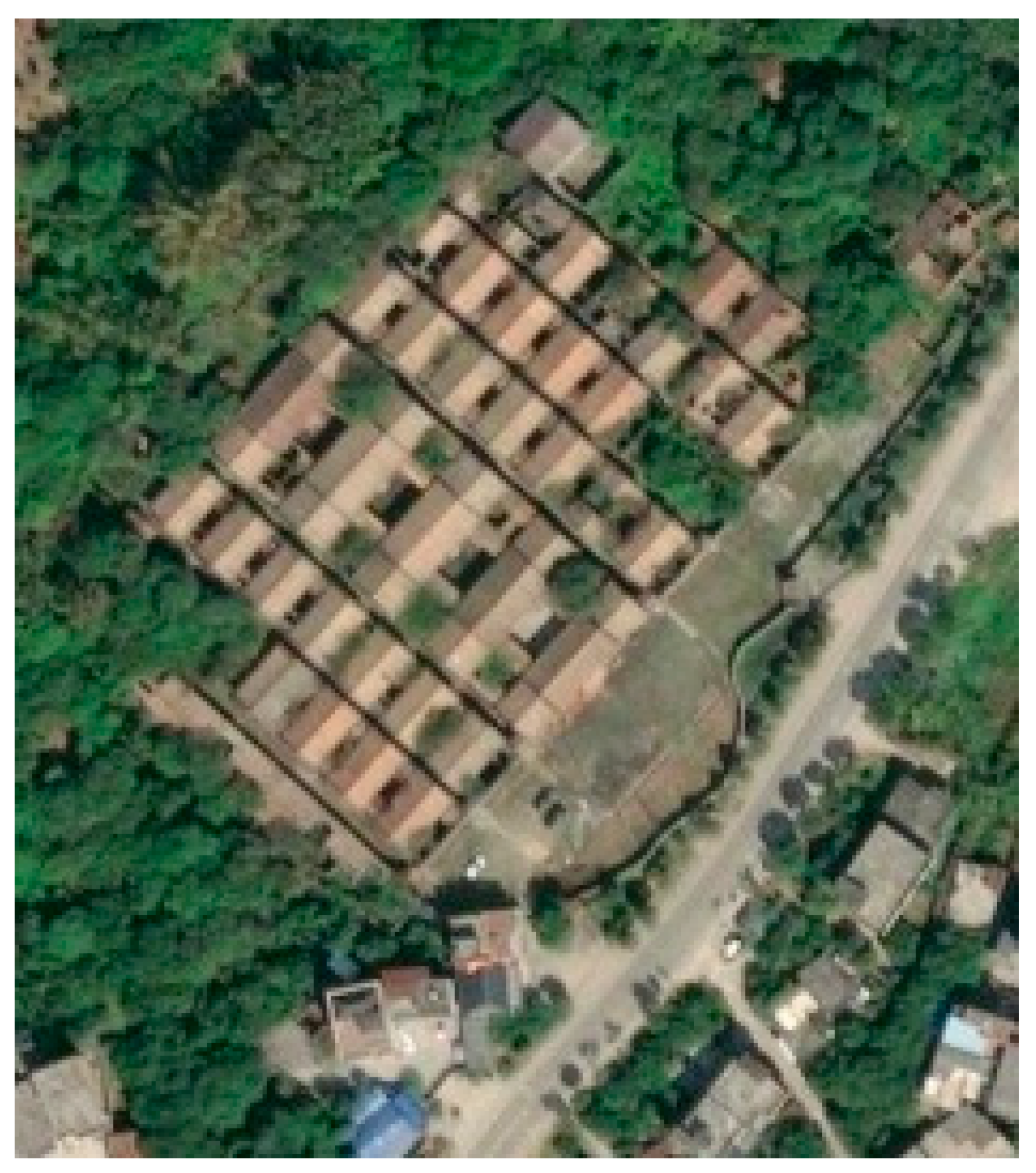
In contrast to the typical comb-like settlement pattern found in the plains of the Dongjiang River Basin—where longitudinal alleys and channels dominate the spatial structure, as exemplified by Zhonglou Village in Guangzhou (Figure 21)—Jiangbian Village adopts a distinctive layout that responds directly to its sloping terrain. The village is organized primarily around transverse alleys and drainage channels, while only three longitudinal alleys and channels function as the principal drainage corridors.
The paddy fields located in front of the village play an important role in retaining stormwater during the rainy season while simultaneously enhancing soil fertility through sediment deposition, demonstrating the ecological resilience of the system. The settlement itself follows a terraced spatial configuration that adapts closely to the natural terrain. This hierarchical arrangement creates a continuous hydraulic pathway extending from the village to the Xiaohai River and ultimately to the Dongjiang River. Through this integrated structure, production, living, and ecological spaces are closely interconnected, endowing the village with both profound spatial significance and long-term structural stability (Figure 22). The aforementioned elements of engineering resilience and ecological resilience are interdependent and together form the underlying logic for stormwater retention and management. Productive paddy fields, residential courtyards and village alleys, and ecological landscape corridors gradually give rise to the cultural landscape order of the “production–living–ecology” triad characteristic of traditional villages.

5. Discussion and Conclusions

5.1. Discussion

Previous studies have shown that infrastructure upgrading has become an important component of traditional village revitalization, encompassing water supply, drainage, sanitation, and ecological disaster prevention systems [37]. However, the water management systems of traditional villages cannot be fully understood through the framework of modern urban drainage infrastructure. Urban drainage systems typically depend on standardized, specialized, and largely independent engineering facilities [38], whereas the drainage and storage elements of traditional villages are deeply embedded within settlement morphology, production and living spaces, and the broader cultural landscape structure [39]. If this intrinsic relationship is overlooked during village renewal and conservation processes, the replacement of historically evolved water management elements with standardized engineering facilities may result in unintended damage to the cultural landscape and a decline in the village’s original capacity to adapt to stormwater and flood-related hazards.
The findings of Jiangbian Village strongly support this perspective. Ponds, channels, paddy fields, threshing floors, and perimeter walls perform not only hydrological functions such as drainage, storage, and flood protection, but also constitute essential components of the cultural landscape sequence characteristic of traditional Cantonese villages. Accordingly, stormwater adaptation in traditional villages should not be viewed primarily as a process of supplementing or replacing modern drainage infrastructure. Rather, it should be grounded in the indigenous logic of traditional water management. Historically evolved drainage and storage elements are not merely remnants of past landscapes; they remain active and functional components of contemporary stormwater resilience. Therefore, preserving the spatial integrity and functional continuity of these traditional water-management elements is critical not only for enhancing flood safety but for sustaining the accumulated ecological knowledge, water-management wisdom, and cultural landscape structure that have shaped Cantonese villages over centuries.

5.2. Conclusions

This study integrates GIS and SWMM to examine the structural characteristics of the drainage and water-storage system in Jiangbian Village and to simulate failure scenarios involving five key drainage and storage components. The results demonstrate that the configuration of the village’s drainage and retention system forms the foundation of its overall landscape structure. This system has not only safeguarded the village against flooding for centuries but has also contributed to the preservation of its cultural landscape integrity. Village walls, channels, threshing floors, ponds, and paddy fields collectively constitute a characteristic cultural landscape sequence of traditional Cantonese villages.
Among these components, ponds are the most critical element of the stormwater management system. A pond failure rate of 25% was identified as the critical threshold for systemic collapse, beyond which flood risk increases dramatically. Failure of the drainage channels alters the original runoff pathways, leading to the spatial redistribution of flow and the occurrence of localized flooding. Paddy fields maintain a relatively stable runoff retention capacity across different rainfall intensities, while perimeter walls and threshing floors effectively buffer residential areas from direct flood inundation. Under normal operating conditions, the system exhibits stable hydrological regulation performance across rainfall events with return periods ranging from 5 to 100 years, demonstrating a high degree of functional redundancy. Even when individual components experience minor failures, the system retains strong self-regulation and buffering capacities, reflecting the resilience of the integrated drainage and storage network.
Owing to its pronounced topographic relief, the drainage pattern of Jiangbian Village is characterized by a network dominated by transverse drainage channels, in contrast to the typical comb-shaped layout of plain Cantonese villages in the Dongjiang River Basin, where longitudinal alleys and drainage corridors generally form the primary framework. This distinctive configuration reflects the traditional wisdom of adapting settlement form and water management strategies to local terrain conditions. The findings highlight the adaptive characteristics of Jiangbian Village as a sloping-terrain Cantonese settlement. Given its unique topography and spatial organization, the conclusions should not be directly generalized to all types of Cantonese villages. Nevertheless, this study provides a valuable reference for understanding stormwater resilience and indigenous water-management practices in other traditional villages with similar terrain conditions and landscape structures.

5.3. Limitation

This study demonstrates the applicability of integrating GIS analysis with the SWMM to investigate the drainage and water-storage systems of traditional villages. However, several limitations should be acknowledged.
This study focuses on Jiangbian Village, a traditional Cantonese village situated on sloping terrain. Its spatial configuration, topographic characteristics, and drainage organization differ substantially from those of lowland Cantonese villages that typically exhibit a comb-like settlement pattern. Consequently, the findings of this study should not be directly generalized to all types of traditional Cantonese villages. Although surveyed elevation points were incorporated into the SWMM to improve terrain representation, precipitation was assumed to be spatially uniform within each sub-catchment, and the built-up area was treated as a relatively integrated analytical unit. These simplifications limit the model’s ability to capture hydrological interactions among individual drainage subareas and may overlook localized runoff dynamics. Furthermore, this study primarily evaluates the hydrological roles of ponds, channels, paddy fields, threshing floors, and perimeter walls through a series of functional degradation scenarios. However, processes such as runoff transfer between spatial units, overflow redistribution, and drainage delays were not explicitly represented in the modeling framework. Future research should include a broader range of traditional villages with different terrain conditions, settlement morphologies, and water-management systems to facilitate comparative analyses. The integration of higher-resolution topographic data, long-term hydrological monitoring, and more sophisticated coupled surface–subsurface hydrological models would further improve the representation of runoff processes and system interactions.
In addition, model parameterization, calibration, and validation were constrained by the lack of long-term hydrological monitoring data within the study area. As a result, direct calibration against observed runoff, water depth, or inundation processes was not possible. Historical hydrological records for traditional rural settlements are often limited in both spatial coverage and accuracy, while field observations during extreme rainfall events are difficult to obtain because of the unpredictable nature of such events. Consequently, the model parameters adopted in this study were primarily derived from technical manuals, field investigations, and previous studies conducted in comparable villages within the same region. Nevertheless, the sensitivity and uncertainty analyses indicate that, within the parameter ranges examined, parameter variations do not alter the overall assessment of the relative importance of the key hydrological elements. Future research should strengthen long-term field monitoring of rainfall, runoff, water depth, inundation extent, and drainage duration. Such data would improve parameter estimation, enhance model calibration and validation, and ultimately increase the reliability of hydrological simulations and resilience assessments in traditional village environments.

Author Contributions

Conceptualization, X.J. and X.Z.; methodology, X.Z.; software, X.Z. and Y.L.; validation, X.J., Y.L. and Y.H.; formal analysis, Y.L.; investigation, X.J., Y.L., Y.H. and X.Z.; resources, Y.H. and X.Z.; data curation, Y.H.; writing—original draft preparation, X.J. and Y.L.; writing—review and editing, Y.H. and X.Z.; visualization, Y.L.; supervision, X.J.; project administration, X.J. and X.Z.; funding acquisition, X.Z. All authors have read and agreed to the published version of the manuscript.

Funding

This research was supported by the National Natural Science Foundation of China (Grant No. 52408019) and the Humanities and Social Sciences Youth Foundation of the Ministry of Education of China (Grant No. 24YJC850020).

Data Availability Statement

The data can be made available upon request to the corresponding author. The data are not publicly available because all core underlying information required for result replication has been fully presented in the manuscript, and the dataset is still being used for our follow-up and extended research.

Conflicts of Interest

The authors declare no conflicts of interest.

References

  1. Academy of Disaster Reduction and Emergency Management. 2024 Global Natural Disaster Assessment Report; Academy of Disaster Reduction and Emergency Management: Beijing, China, 2025; pp. 7–8. [Google Scholar]
  2. China Tourism News. Shanxi Province Conducts Orderly Emergency Repairs on Ancient Buildings Travel Companies Promptly Ensure Tourist Support. Available online: https://www.mct.gov.cn/whzx/qgwhxxlb/sx/202110/t20211013_928303.htm (accessed on 4 May 2026).
  3. Wang, M.M.; Wang, R. The ecological wisdom of the traditional village’s drainage system—Taking diaoyuan village in jiangxi province as an example. J. Jinggangshan Univ. (Nat. Sci.) 2016, 37, 71–77. [Google Scholar] [CrossRef]
  4. Holling, C.S. Resilience and Stability of Ecological Systems. Annu. Rev. Ecol. Syst. 1973, 4, 1–23. [Google Scholar] [CrossRef]
  5. Dekker, S.; Hollnagel, E.; Woods, D.; Cook, R. Resilience Engineering: New Directions for Measuring and Maintaining Safety in Complex Systems; Lund University School of Aviation: Lund, Sweden, 2008; Volume 1, pp. 1–6. Available online: https://api.semanticscholar.org/CorpusID:18646868 (accessed on 23 June 2026).
  6. Zhu, Z.W.; Liu, Y.Y.; Yang, Y. Resilient Governance: Practice and Exploration of Urban Resilience Building in China. Public Adm. Policy Rev. 2021, 10, 22–31. [Google Scholar] [CrossRef]
  7. Best, J.; Ashmore, P.; Darby, S.E. Beyond Just Floodwater. Nat. Sustain. 2022, 5, 811–813. [Google Scholar] [CrossRef]
  8. Birkmann, J.; Truedinger, A.; Schuettrumpf, H. The Impact of Science: Uptake of Scientific Recommendations after Extreme Events—Case Study Floods in 2021 in Germany. J. Flood Risk Manag. 2025, 18, e70100. [Google Scholar] [CrossRef]
  9. Higuera Roa, O.; Bachmann, M.; Mechler, R.; Šakić Trogrlić, R.; Reimann, L.; Mazzoleni, M.; Aerts, J.C.; Buskop, F.E.; Pirani, A. Challenges and opportunities in climate risk assessment: Future directions for assessing complex climate risks. Environ. Res. Lett. 2025, 20, 053003. [Google Scholar] [CrossRef]
  10. Ross, A.D.; Nejat, A.; Greb, V. Institutional Foundations of Adaptive Planning: Exploration of Flood Planning in the Lower Rio Grande Valley, Texas, USA. Sustain. Resilient Infrastruct. 2023, 8, 419–436. [Google Scholar] [CrossRef]
  11. Tao, X.D. Building Resilient Mega and Super⁃large Cities in China: Theoretical Logic, Practical Exploration and Pathway Choices. Nanjing J. Soc. Sci. 2025, 7, 65–73. [Google Scholar] [CrossRef]
  12. Henderson, F.; Bennett, B.; Dohain-Lesueur, R.; Helwig, K. ‘It’s Not Really Their Problem’: Reactive Institutional Community Engagement and Flood Policy Implementation. Int. J. Disaster Risk Reduct. 2025, 116, 105096. [Google Scholar] [CrossRef]
  13. Laurien, F.; Hochrainer-Stigler, S.; Keating, A.; Campbell, K.; Mechler, R.; Czajkowski, J. A Typology of Community Flood Resilience. Reg. Environ. Change 2020, 20, 24. [Google Scholar] [CrossRef]
  14. Dong, W.L.; Chen, X.W. Research on Planning and Decision-Making for Resilient Communities with Multi-Stakeholder Participation. Mod. Urban Res. 2025, 2025, 20–28. [Google Scholar] [CrossRef]
  15. Green, D.; O’Donnell, E.; Johnson, M.; Slater, L.; Thorne, C.; Zheng, S.; Stirling, R.; Chan, F.K.S.; Li, L.; Boothroyd, R.J. Green Infrastructure: The Future of Urban Flood Risk Management? WIREs Water 2021, 8, e1560. [Google Scholar] [CrossRef]
  16. Li, H.Y.; Wang, Q.; Xu, X.X. Multi-scale Blue-Green-Grey Infrastructure System Under Rainstorm Resilience Orientation: The -oretical Framework and Synergistic Pathway. J. Urban Sci. 2025, 3, 34–40. Available online: https://d.wanfangdata.com.cn/periodical/chengs202501005 (accessed on 23 June 2026).
  17. Taheri, P.; Alavi Moghaddam, M.R.; Piadeh, F. Sustainability Assessment of Low-Impact Development Methods for Urban Stormwater Management: A Multi-Criteria Decision-Making Approach. Sustain. Cities Soc. 2025, 118, 106025. [Google Scholar] [CrossRef]
  18. Borna, M.; Borna, M.; Jorabloo, M. Performance Assessment of LID Techniques to Control Urban Floods under Historical and Future Rainfall and Land Cover Scenarios. Water Resour. Manag. 2025, 39, 5637–5652. [Google Scholar] [CrossRef]
  19. Halder, S.; Das, S.; Basu, S. Effectiveness of Hapa as Small Rainwater Harvesting Ponds for Sustainable Agricultural Development in Diversified Arid Regions: Comparative Case Studies from Bankura in India. J. Rural Dev. 2023, 42, 198–217. [Google Scholar] [CrossRef]
  20. Zhou, Y.; Guo, H. People-Water-City: Village Urban Form Shaped by Water-Retaining Ponds. In Routledge Handbook of Sustainable Design; Routledge: Abingdon, UK, 2025; Chapter 9; Available online: https://www.taylorfrancis.com/chapters/oa-edit/10.4324/9781003509936-9/people-water-city-yinan-zhou-huazhan-guo (accessed on 21 May 2026).
  21. Sentani, A.; Niam, M.F. Retention Pond Planning for Flood Management Using EPA SWMM in Sayung Village Demak Regency. J. Adv. Civ. Environ. Eng. 2023, 6, 81–89. [Google Scholar] [CrossRef]
  22. Ismail, Y.; Lestari, D.A. Analysis of Drainage System Using EPA SWMM 5.1, Case Study: Setia Asih Village, Bekasi District. AIP Conf. Proc. 2022, 2534, 030004. [Google Scholar] [CrossRef]
  23. Han, Y.; Li, W.; Zheng, T.; Ge, G.; Feng, K.; Gao, P.; Cheng, W. The Difference between Drainage Channels and Sewers in Rural Areas: From Sewage Quality to Bacterial Characteristics. Water Sci. Technol. 2022, 86, 2385–2395. [Google Scholar] [CrossRef] [PubMed]
  24. Sharma, A.; Ji, S. Linkages between Traditional Water Systems and Sustainable Development Goals: A Case of Govardhan, India. Soc. Sci. Humanit. Open 2024, 9, 100816. [Google Scholar] [CrossRef]
  25. Lin, Z.; Liu, L.; Wang, D.; Zhang, D. Ecological Wisdom and Inheritance Thinking of the Traditional Village’s Water Resources Management in Taihang Mountains. J. Asian Archit. Build. Eng. 2024, 23, 1034–1050. [Google Scholar] [CrossRef]
  26. Jiang, X.; He, S.; Li, Z. A Study on the Water Management Knowledge of Traditional Villages from the Perspective of Stormwater Resilience: A Case Study of Changqi Ancient Village in Guangdong, China. Sustainability 2024, 16, 9807. [Google Scholar] [CrossRef]
  27. Li, J.; Zhou, W.; Tao, C. The Value of Traditional Ecological Knowledge in Stormwater Management: A Case Study of a Traditional Village. Land 2024, 13, 242. [Google Scholar] [CrossRef]
  28. Li, J.; Zhou, W.; Tao, C. The Impact of Urbanization on Surface Runoff and Flood Prevention Strategies: A Case Study of a Traditional Village. Land 2024, 13, 1528. [Google Scholar] [CrossRef]
  29. Pearl River Water Resources Commission. Pearl River Water System and Its Origin. In A Brief History of Pearl River Water Conservancy; China Water & Power Press: Beijing, China, 1990; p. 12. Available online: https://www.libraryceo.com/chilin/opac/index.php?page=opacInfo&id=0013077 (accessed on 9 May 2026).
  30. Yang, D. Research of Traditional Village Drainage Spatial Form of the Pearl River Delta Based on Flood Control and Waterlog Draining. Master’s Thesis, Harbin Institute of Technology, Harbin, China, 2015. Available online: https://cdmd.cnki.com.cn/Article/CDMD-10213-1016702338.htm (accessed on 23 June 2026).
  31. Lewis, A. Rossman User Manual for Storm Water Management Model SWMMH, Version 5.0; United States Environmental Protection Agency: Washington, DC, USA, 2010. [Google Scholar]
  32. Jiang, Q.; Yu, K.; Wang, Z. Rainwater Storage and Regulation Capacity of Beitang System Based on SWMM and Its Application. China Water Wastewater 2018, 34, 132–138. [Google Scholar] [CrossRef]
  33. Rossman, L. Rainwater Parameter Estimates. In Storm Water Management Model Reference Manual—Hydrology (Revised); United States Environmental Protection Agency: Cincinnati, OH, USA, 2016; Volume 1, pp. 173–178. Available online: https://www.epa.gov/water-research/storm-water-management-model-swmm (accessed on 9 May 2026).
  34. Rossman, L. Rainwater Parameter Estimates. In Storm Water Management Model Reference Manual—Hydraulics (Revised); United States Environmental Protection Agency: Cincinnati, OH, USA, 2017; Volume 2, pp. 75, 95–96. Available online: https://www.epa.gov/water-research/storm-water-management-model-swmm (accessed on 9 May 2026).
  35. Zhu, J.; Xu, X.; He, S. An Analysis of Parameter Sensitivity of SWMM Model Based on LH-OAT Method. China Rural Water Hydropower 2014, 2014, 84–87. [Google Scholar] [CrossRef]
  36. Guangdong Provincial Meteorological Disaster Prevention Technology Service Center. Dongguan City Heavy Rainfall Intensity Formula and Calculation Chart. Available online: https://max.book118.com/html/2021/0701/5321033210003302.shtm (accessed on 9 May 2026).
  37. Hesarkazzazi, S.; Bakhshipour, A.E.; Hajibabaei, M.; Dittmer, U.; Haghighi, A.; Sitzenfrei, R. Battle of centralized and decentralized urban stormwater networks: From redundancy perspective. Water Res. 2022, 222, 118910. [Google Scholar] [CrossRef] [PubMed]
  38. Rodriguez, M.; Fu, G.; Butler, D. Green Infrastructures and Their Impact on Resilience: Spatial Interactions in Centralized Sewer Systems. In Proceedings of the 3rd ACM SIGSPATIAL International Workshop on Advances in Resilient and Intelligent Cities, Seattle, WA, USA, 3 November 2020; pp. 49–57. [Google Scholar] [CrossRef]
  39. Wang, Z.; Zhuang, Q.; He, X. The Construction Mechanism of Landscape Patterns: A Case Study of Traditional Villages in the Pearl River Delta Region. J. Asian Archit. Build. Eng. 2025, 24, 1–20. [Google Scholar] [CrossRef]
Figure 1. Distribution map of flood disaster types in traditional villages of the Dongjiang River Basin.
Buildings 16 02723 g001
Figure 2. Distribution map of flood disaster types in traditional villages of Dongguan City.
Buildings 16 02723 g002
Figure 3. Jiangbian Village location analysis map (Xiaohai River, a minor tributary of the Dongjiang River, lies adjacent to Jiangbian Village).
Buildings 16 02723 g003
Figure 4. System map of Jiangbian Village.
Buildings 16 02723 g004
Figure 5. Topographic analysis of runoff and waterlogging conditions in Jiangbian Village.
Buildings 16 02723 g005
Figure 6. Rainwater flow and drainage organization influenced by the Luowu Ridge in Jiangbian Village. (a) Schematic diagram of rainwater flow direction from Luowu Ridge; (b) layout of channels inside and outside the southern perimeter wall.
Buildings 16 02723 g006
Figure 7. Drainage channel forms in Jiangbian Village.
Buildings 16 02723 g007
Figure 8. Map of the drainage system in Jiangbian Village.
Buildings 16 02723 g008
Figure 9. Drainage catchments and runoff flow directions in Jiangbian Village.
Buildings 16 02723 g009
Figure 10. Schematic diagram of cultural landscape elements and stormwater retention system in Jiangbian Village.
Buildings 16 02723 g010
Figure 11. Watershed map.
Buildings 16 02723 g011
Figure 12. Schematic diagram of the drainage system.
Buildings 16 02723 g012
Figure 13. Rainfall simulation for Dongguan City under different return periods.
Buildings 16 02723 g013
Figure 14. Hydraulic response of node J14 under the pond-failure scenario in Jiangbian Village. (a) Peak water depth under different return periods; (b) variation in peak water depth compared with the intact drainage–storage system.
Buildings 16 02723 g014
Figure 15. System storage and flooding response under the pond-failure scenario in Jiangbian Village. (a) Final retained storage volume of the system; (b) surface flooding volume; (c) number of flooded nodes.
Buildings 16 02723 g015
Figure 16. Hydraulic response of key nodes under the drainage-channel-failure scenario in Jiangbian Village. (a) Peak water depth at node J12; (b) peak water depth at node J13; (c) peak water depth at node J14.
Buildings 16 02723 g016
Figure 17. Hydrographs of key nodes under the drainage-channel-failure scenario in Jiangbian Village under the 100-year return period.
Buildings 16 02723 g017
Figure 18. System flooding and retention response under the drainage-channel-failure scenario in Jiangbian Village.
Buildings 16 02723 g018
Figure 19. System flooding and runoff response under the paddy-field-failure scenario in Jiangbian Village. (a) Surface flooding volume under different degrees of paddy field failure; (b) total runoff volume under different degrees of paddy field failure.
Buildings 16 02723 g019
Figure 20. System flooding and runoff response under the threshing-floor-failure scenario in Jiangbian Village. (a) Total surface flooding volume of the system; (b) change in total runoff volume relative to the intact condition.
Buildings 16 02723 g020
Figure 21. Traditional comb-shaped village layouts.
Buildings 16 02723 g021
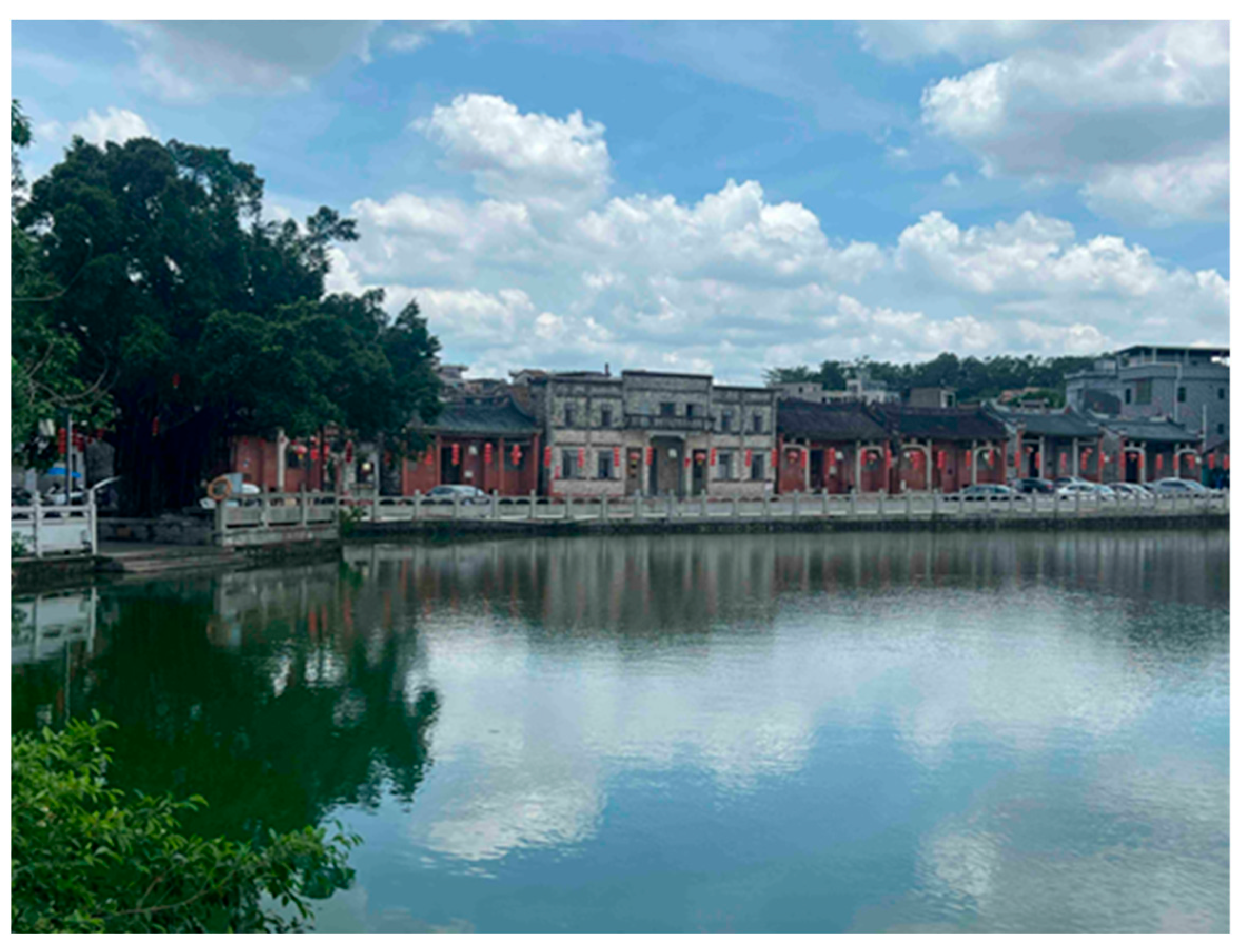
Figure 22. Landscape view of Riverside Village.
Buildings 16 02723 g022
Table 1. Statistics on traditional Chinese villages in the Dongjiang River Basin.
CityLevelQuantity (Units)Distance from the Main River (Kilometers)
DongguanNational61.7–11.6
Provincial60.1–11
GuangzhouNational20.1–2.9
HuizhouNational120.3–11.2
Provincial21–4.2
HeyuanNational160.2–12.7
Total (units)44
Table 2. Comparison table of cross sections of drainage channels at village entrances along the riverbank.
LocationConventional ChannelsJoint Trench
Cross Street & Long Street
Intersection
Buildings 16 02723 i001Buildings 16 02723 i002Buildings 16 02723 i003
I. A channel in a lane within the enclosureII. The channel at the bend of a lane within the enclosure
Mid-lane & Lane
entrance
Buildings 16 02723 i004Buildings 16 02723 i005Buildings 16 02723 i006
I. Central Drainage Channel in East Xingren LaneII. Channel at the northern entrance of East Xingren Lane
Mid-lane & Lane
entrance
Buildings 16 02723 i007Buildings 16 02723 i008Buildings 16 02723 i009
I. Central Drainage Channel in Lane 4, XingrenliII. Channel at the eastern entrance of Lane 4, Xingrenli
Gentle-slope
channel
&
Steep-slope channel
Buildings 16 02723 i010Buildings 16 02723 i011Buildings 16 02723 i012
I. Drainage Channel in Lane 4, Xingrenli II. Drainage Channel in Lane 6, Xingrenli (steep-slope channel)
Table 3. Basic information of the sub-catchment.
Sub-CatchmentLand-Use TypeArea (ha)Avg. Slope (%)Imperviousness (%)Max Infil. Rate (mm/h)
ZMJ01Pond0.872.39015
ZMJ02Pond0.783.27015
ZMJ03Pond2.023.03015
ZMJ04Pond0.533.82015
ZMJ05Pond2.014.96015
ZMJ06-IForest1.6416.471.53130
ZMJ06-IIForest6.7815.131.53130
ZMJ06-IIIForest25.1111.311.53130
ZMJ07Forest21.766.362.67130
ZMJ08Forest3.63.652.826120
ZMJ09Threshing floor1.874.0868.3915
ZMJ10Threshing Floor0.635.9289.1115
ZMJ11Traditional Village2.457.5376.2750
ZMJ12Traditional Village0.844.4679.2250
ZMJ13New Village4.995.271.1725
ZMJ14New Village1.874.8379.7825
ZMJ15New Village8.355.6374.6725
ZMJ16Threshing floor0.4298.7715
ZMJ17New Village11.431.4270.8825
ZMJ18Paddy Field18.822.846.6840
Table 4. Empirical parameter values.
Empirical ParametersBaseline Value
N-Imperv [26,31,33]0.014
N-Perv [26,31]0.24
Dstore-Imperv (mm)
[31,33]
1.27
Dstore-Perv (mm) [31,34]5
Zero-Imperv (%) [31]25
Max. Infil. Rate (mm/h) [31]15–130
Min. Infil. Rate (mm/h) [27,31,34]6.8
Decay Constant (1/h) [31]3.5–4.5
Drying Time (day) [26,27,31]7
Table 5. Sensitivity index (SI) of SWMM parameters.
ParameterJ14 Depth SIJT3 Util. SIJT4 Util. SIMean |SI|Sensitivity LevelDirection
Min Infil. Rate−0.0620−0.0654−0.40100.1761Moderate
Imperviousness0.02010.04490.27350.1128Moderate+
n-Perv−0.1332−0.0268−0.16810.1094Moderate
Slope0.05490.01420.09790.0557Low+
Dstore-Perv−0.0078−0.0124−0.08410.0348Low
Decay Constant0.00990.01060.06420.0282Low+
Max Infil. Rate−0.0022−0.0059−0.03810.0154Low
Dstore-Imperv0.0000−0.0004−0.00460.0017Insensitive
n-Imperv0.0000−0.0003−0.00200.0008Insensitive
Zero-Imperv0.00000.00000.00070.0002Insensitive+
Drying Time0.00000.00000.00000.0000Insensitive0
Table 6. Pond failure conclusion across all 9 parameter combinations.
Return PeriodJ14
Intact Range (m)
Intact Baseline (m)J14 Failed Range (m)Failed Baseline (m)Change RangeBaseline ChangeFlooded Nodes RangeBaseline Nodes
5a0.47–0.550.510.58–0.670.6320.8–23.5%23.50%7-July7
10a0.51–0.580.550.62–0.710.6720.8–23.2%21.80%7-July7
20a0.54–0.610.580.66–0.750.7121.1–23.7%22.40%7-July7
50a0.58–0.650.620.71–0.800.7621.3–23.1%22.60%7-July7
100a0.61–0.680.650.75–0.830.821.9–23.8%23.10%8-July7
Table 7. Scenario design for infrastructure failure analysis.
Scene NumberScenario CategorySimulated ScenarioFailure LevelsModeling Approach
Control GroupAll elements are providedThe existing flood drainage and storage system functions at full design capacity.0%Simultaneous adjustment of target parameter across all sub-catchments
Scenario 1Pond FailurePonds are simulated as backfilled, making their storage capacity invalid.25%, 50%, 75%, 100%depth_max scaled by (1 − ratio × 0.99)
Scenario 2Channel FailureChannels are simulated as silted up or blocked, causing total drainage dysfunction.25%, 50%, 75%, 100%Cross-section height and width scaled by (1 − ratio × 0.90)
Scenario 3Paddy Field FailurePaddy fields are simulated as converted into impermeable construction land, leading to a complete loss of retention capacity.25%, 50%, 75%, 100%Improve Imperviousness, and ST1 depth_max scaled by (1 − ratio × 0.90)
Scenario 4Threshing Floor FailureThreshing floors are simulated as occupied or paved, depriving them of depression storage function.25%, 50%, 75%, 100%Depression storage linearly reduced to 0
Table 8. Water storage gauge for Jiangbian Village drainage and storage system under efficient collaboration.
Pond LabelPercentage of Maximum Storage Capacity for Water Retention Facilities Such as Ponds and Paddy Fields at Different Return Periods
/%
Maximum Overflow Volume
/106 L
100a50a20a10a5a0
JT186746052460
JT21815121090
JT398959187810
JT4100937154323.755
JT520191716150
JT696887157520
ST1 *75675750440
* ST1 is paddy fields, regarded as water storage facilities in the simulation.
Disclaimer/Publisher’s Note: The statements, opinions and data contained in all publications are solely those of the individual author(s) and contributor(s) and not of MDPI and/or the editor(s). MDPI and/or the editor(s) disclaim responsibility for any injury to people or property resulting from any ideas, methods, instructions or products referred to in the content.