1. Introduction
This introduction establishes the conceptual basis for the argument developed in the paper. It situates Urban Digital Twins within City Information Modelling, introduces the imperative–declarative distinction, and prepares the analytical framework for the comparative case studies.
1.1. Urban Complexity and the Limits of Conventional Planning Instruments
Cities increasingly operate as complex systems in which spatial, social, ecological, economic, and infrastructural dynamics are deeply entangled. These dynamics unfold across multiple spatial and temporal scales, involve heterogeneous actors with divergent interests, and evolve in ways that resist linear prediction. As a consequence, urban planning and design must address problems that are not merely complicated, but complex, in the sense that interactions are non-linear, feedback-driven, and context-dependent [
1,
2].
Conventional planning instruments have historically relied on static representations, sectoral compartmentalisation, and sequential decision-making. While such approaches remain effective for well-bounded problems, they struggle to engage systemic complexity without excluding relations that shape long-term urban transformation. The challenge is therefore not only to produce more data or more accurate models, but to structure urban information in ways that support collective reasoning, interpretation, and coordination. This shift reframes the role of digital modelling in urban contexts: models do more than analyse data; they also structure how complexity becomes intelligible within collective planning processes.
1.2. Digital Technologies and the Rise in Urban Digital Twins
Over the past two decades, digital technologies such as Geographic Information Systems (GIS), Building Information Modelling (BIM), and data-driven analytics have expanded the analytical capacity of planners and designers. More recently, Urban Digital Twins (UDTs) have emerged as a prominent paradigm, often described as dynamic, data-rich representations capable of mirroring urban reality in near real time [
3,
4]. In much of the current discourse, UDTs are presented as platforms that combine data ingestion, simulation, and visualisation to support scenario testing and performance evaluation. While these developments offer clear advantages, they are often accompanied by assumptions of determinacy and control, suggesting that urban complexity can be rendered transparent, optimised, or governed through computational mirroring.
As Batty [
3] has cautioned, such assumptions risk conflating modelling with reality and overlooking the limits of digital representation. This paper therefore treats the limitations of UDTs not primarily as technical, but as conceptual. The following sections, therefore, reposition UDTs within a broader framework for urban information and modelling.
1.3. City Information Modelling: From Conceptual Origin to Epistemic Infrastructure
City Information Modelling (CIM) emerged in the late 2000s within architectural computation discourse as an attempt to extend information modelling principles beyond individual buildings to the urban scale. Early formulations, most notably by Montenegro and Duarte [
5], conceptualised CIM as a computational ontology for urban design—an approach capable of structuring consistent descriptions of urban form, regulation, and transformation. At its inception, CIM sought to overcome fragmentation between geometric modelling, regulatory frameworks, and spatial analysis by proposing a shared informational foundation for urban reasoning. Since its introduction, the term has been interpreted in multiple ways. In some strands of practice and research, it has been equated with the large-scale extension of Building Information Modelling (BIM) to the city. In others, it has been associated with smart city data platforms, urban dashboards, or integrated GIS environments. These interpretations emphasise data integration, interoperability, and platform architecture, and they have contributed significantly to digital urban modelling. However, they often foreground technical integration over conceptual orientation. This paper therefore adopts a more specific and theoretically grounded understanding of CIM. Rather than defining it primarily as a technical platform or data aggregation environment, CIM is understood here as an epistemic and organisational infrastructure that structures how urban information is encoded, related, interpreted, and mobilised across institutional contexts.
In this view, CIM does not prescribe a single modelling logic. Instead, it establishes the informational conditions under which different modelling paradigms can operate coherently and comparably over time. It therefore exceeds the notion of “BIM at the city scale” and cannot be reduced to a digital twin platform. CIM provides a framework within which urban models—whether evaluative, relational, predictive, or exploratory—can be articulated as components of a broader informational ecology. Its significance lies in enabling continuity, comparability, and interpretability across heterogeneous data sources, modelling approaches, and stakeholder perspectives.
1.4. Repositioning Urban Digital Twins Within City Information Modelling
From the perspective advanced in this paper, UDTs operationalise CIM rather than replacing it. Where CIM provides the organisational and epistemic infrastructure for structuring urban information, UDTs enact specific modelling orientations within that infrastructure. They define how urban information is reduced, stabilised, and made interpretable in response to particular planning and interpretive demands. Depending on context, these operative configurations may take the form of relatively stabilised evaluative applications or more open-ended processes of twinning. This repositioning has three important consequences. First, it shifts attention from the technological sophistication of digital twins to their modelling logic and conceptual orientation. Second, it clarifies that multiple forms of Urban Digital Twinning may coexist within a single CIM framework, each responding to different planning conditions and governance requirements. Third, it prevents the reification of digital twins as endpoints by framing them as dynamic components of ongoing informational structuring.
The central analytical question therefore becomes: what modelling orientation does a given UDT enact within CIM, and how does that orientation shape collective engagement with urban complexity? In this sense, the paper does not test digital twins as a unified technological category, but reframes UDTs in relation to CIM by distinguishing different twinning modes and examining how they become operationally legible across contrasting case contexts.
1.5. Imperative and Declarative Paradigms: Theoretical Grounding
To clarify these differences, the paper draws on the distinction between imperative and declarative paradigms, originally articulated in computer science and logic. In imperative paradigms, systems are defined in terms of how outcomes are achieved through explicit procedures and control flows [
6]. In declarative paradigms, systems are defined in terms of what conditions or relations should hold, without prescribing how they are realised, as in logic programming, constraint-based systems, and relational databases [
7,
8].
This distinction reflects two different orientations toward complexity. Imperative approaches privilege control, determinacy, and procedural transparency, while declarative approaches privilege relational structure, constraint satisfaction, and interpretability. When translated into planning and urban modelling, these paradigms correspond to distinct ways of making complexity usable. Imperative approaches are closely aligned with multi-criteria decision analysis and performance-based planning, where urban ambitions are translated into measurable indicators and optimisation criteria [
9,
10]. Declarative approaches, by contrast, align with complexity-oriented perspectives that emphasise emergence, relationality, and sense-making rather than optimisation [
1].
1.6. Imperative and Declarative Modes in Urban Digital Twinning
Within CIM, imperative and declarative paradigms manifest as distinct modes of Urban Digital Twinning. The distinction concerns not the degree of technical sophistication of a model, but the way urban complexity is reduced, stabilised, and made collectively usable. Imperative modes prioritise determination, evaluation, and resolution. They translate urban ambitions and constraints into indicators, KPIs, thresholds, and comparative metrics that support benchmarking, justification, and decision-making. Their strength lies in making trade-offs explicit in situations where objectives must be clarified, compared, and defended. Declarative modes adopt a different stance. Grounded in relational and constraint-based paradigms, they operate through reduced complex models that preserve ambiguity, noise, and latent relations. Rather than producing determinate outcomes, these models make underlying urban structures perceptible and support collective interpretation where evaluative closure would be premature.
Crucially, declarative approaches are not experimental in a trial-and-error sense, nor speculative in a utopian sense. They are instruments for articulating sense from complexity without forcing early resolution. In this respect, declarative twinning does not stand outside practice; it supports early-stage urban reasoning by making spatial and environmental relations available for interpretation before they are translated into evaluative criteria. In the present paper, this orientation is operationalised in the Graz case through a methodological approach informed by Natural Communication theory [
11], used not as a general theory of urban systems, but as a methodological basis for preserving structural correspondences across heterogeneous datasets under conditions of epistemic uncertainty.
1.7. Urban Digital Twinning—Analytical Framework
To ensure conceptual clarity and analytical consistency, the distinction between imperative and declarative UDT is formalised here through a set of explicit analytical criteria. These criteria are derived from their respective orientations in computer science, decision theory, and complexity studies and are translated into a comparative framework applicable within CIM. The comparison therefore examines how UDTs differ in epistemic aim, reduction strategy, output form, treatment of uncertainty, boundary-object function, and validation logic. These criteria provide the basis for the comparative reading of the three case studies that follow, allowing their differences to be examined through a shared analytical structure rather than through project-specific descriptions alone. The modes are not mutually exclusive or hierarchical, but complementary operations within CIM that become productive under different institutional and planning conditions.
1.8. Boundary Objects and Collective Urban Cognition
Both imperative and declarative UDTs function as boundary objects in the sense articulated by Star and Griesemer [
12]. They enable cooperation across disciplinary and institutional boundaries while accommodating multiple interpretations. Their difference lies not in their collective nature, but in the type of collective cognition they support. Imperative UDTs stabilise cooperation around shared evaluative criteria, allowing stakeholders to compare priorities, justify decisions, and negotiate trade-offs. Declarative UDTs, by contrast, open a shared perceptual field in which actors can articulate emerging relations and uncertainties before these are stabilised into criteria or targets.
1.9. Aim and Structure of the Paper
The aim of this paper is to clarify the role of UDTs within CIM by theoretically grounding and operationalising the imperative–declarative distinction through concrete case studies. Two practice-oriented applications from the Netherlands illustrate imperative modes of UDT, while an exploratory research project in Graz, Austria, demonstrates a declarative, processual approach grounded in Natural Communication theory. The paper proceeds by elaborating the conceptual foundations of digital models, reduction, and boundary objects within CIM, followed by case analyses, comparative discussion, and reflections on governance and institutional implications.
Methodologically, the paper adopts a comparative conceptual–analytical case study design. The three cases are not treated as equivalent empirical samples, but as distinct operational contexts through which different twinning orientations become legible within a shared CIM perspective. The analysis is structured through the criteria introduced in
Table 1, with explicit attention to epistemic aim, reduction strategy, data sources, spatial units, transformation procedures, output forms, uncertainty treatment, boundary-object function, and validation logic. The analysis proceeds by first defining the comparative criteria theoretically, then examining how each case operationalises them, and finally synthesising the differences and complementarities between the modes. The aim is not statistical generalisability, but conceptual clarification of how imperative and declarative modes of UDT are instantiated and made collectively usable under different institutional and planning conditions.
2. Digital Models, Reduction, and Boundary Objects in City Information Modelling
This section defines the conceptual tools used to compare the three case studies that follow. Rather than introducing additional model categories, it clarifies how digital models can be examined in terms of reduction, boundary-object function, and processual orientation, thereby establishing the analytical basis for the comparative reading developed in the remainder of the paper.
2.1. Digital Models as Epistemic Instruments in Urban Contexts
Within CIM, digital models function not merely as representations of urban reality, but also as epistemic instruments that shape what can be perceived, compared, negotiated, and acted upon.
In urban contexts, this epistemic role is particularly critical. Cities are not only spatial artefacts but dynamic systems in which physical configurations, social practices, regulatory frameworks, and environmental processes interact across multiple scales.
Any digital model, therefore, necessarily performs a selection: it foregrounds certain relations while backgrounding others. The question is not whether a model is complete or accurate—an ideal already problematised in digital twin discourse—but what kind of engagement with complexity a given modelling approach enables.
Within CIM, digital models organise collective reasoning by conditioning how complexity is rendered intelligible, how comparisons are made, and what kinds of action become possible.
Crucially, this epistemic function is not uniform across modelling approaches. As introduced in
Section 1, different modelling paradigms embody different orientations toward complexity. To understand how imperative and declarative UDTs operate within CIM, it is therefore necessary to examine the mechanisms through which digital models reduce complexity.
2.2. Reduction Versus Simplification in Urban Modelling
A central challenge in modelling urban systems lies in distinguishing reduction from simplification. As Bühlmann [
13] has argued, the difference is not merely terminological, but also epistemically consequential. Simplification reduces complexity by excluding elements deemed secondary or irrelevant, often in the pursuit of clarity, efficiency, or computational tractability. While simplification can be effective for narrowly scoped or well-bounded problems, it risks erasing relational structures that are essential to understanding complex urban dynamics.
Reduction, by contrast, does not eliminate complexity but translates it. Reduced models preserve relational structures, latent patterns, and systemic interdependencies, even when operating at lower dimensionality or abstraction. Rather than removing complexity, reduction reorganises it into forms that can be perceived, interpreted, and reasoned about.
This distinction is particularly relevant within CIM. CIM does not aim to exhaustively represent urban reality, but to structure urban information in ways that support collective reasoning, interpretation, and coordination. Reduced models function as mediating constructs: they make certain relations visible while maintaining openness to reinterpretation as conditions change.
Architectural and urban theory has long recognised the productive role of reduction in modelling. Reduced models do not seek to mirror reality, but to render it intelligible by articulating essential relations. In this sense, reduction is not a loss of information but a reconfiguration of it, enabling forms of reasoning that would otherwise remain inaccessible.
Imperative and declarative UDTs differ fundamentally in how they enact reduction. Imperative models tend to reduce complexity by translating it into indicators, thresholds, and evaluative metrics that facilitate comparison and decision-making.
Declarative models reduce complexity by translating it into relational structures and latent configurations, without forcing evaluative closure or determinate outcomes. These differences are not merely technical; they reflect distinct conceptual commitments regarding how complexity should be engaged.
2.3. Boundary Objects and the Organisation of Collective Reasoning
The concept of boundary objects provides a useful lens for understanding how digital models operate within CIM. Boundary objects are not defined by their technical composition, but by their capacity to mediate cooperation across heterogeneous social worlds. Boundary objects enable different actors to work together without requiring full consensus on meaning, methods, or objectives.
UDTs, when situated within CIM, function as boundary objects precisely because they stabilise a shared informational reference while remaining open to multiple interpretations. They do not resolve disagreements; rather, they provide a common ground on which disagreements can be articulated, negotiated, and transformed into collective reasoning processes.
Importantly, the boundary-object function of UDTs is not uniform. Imperative and declarative modes organise collective reasoning in different ways:
Imperative UDTs stabilise collective reasoning around shared evaluative criteria. By translating ambitions and constraints into KPIs, thresholds, and metrics, they make trade-offs explicit and comparable, thereby supporting alignment toward decisions.
Declarative UDTs expand collective reasoning by foregrounding latent structures, relational patterns, and ambiguities. They support negotiation by widening interpretive space, allowing actors to articulate meaning before committing to determinate outcomes.
Both modes are collective, but they support different forms of collective reasoning.
2.4. Digital Twins as Applications Versus Processes of Twinning
A further distinction relevant to CIM concerns the status of the UDT itself. In many practice-oriented contexts, digital twins are conceived as applications: platforms that integrate data, analytics, and visualisation to support predefined tasks such as monitoring, evaluation, or scenario comparison.
While such applications are valuable, this conception risks reifying the digital twin as a product rather than a process. From a CIM perspective—particularly in declarative modes—it is more appropriate to speak of processes of twinning. Twinning, in this sense, refers to the ongoing articulation between urban systems and their informational counterparts, mediated through cycles of encoding, transformation, and interpretation.
This processual understanding is essential for engaging urban complexity over time. Cities evolve, data sources change, and interpretations shift. Declarative UDTs embrace this fluidity by treating the digital model not as a final representation but as a continuously re-articulated reduced model, whose value lies in sustaining interpretive engagement rather than delivering definitive answers. Imperative UDTs may also involve iteration, but they tend to stabilise models around predefined evaluative criteria. Declarative twinning remains structurally open, preserving the possibility of re-interpretation as new relations emerge.
2.5. Justifying the Case Study Contexts: Epistemic Opportunity Rather than Cultural Comparison
The selection of case studies in the Netherlands and Austria is not intended as a comparison of national planning cultures, institutional traditions, or socio-political contexts. Rather, the cases are positioned to examine how different modes of Urban Digital Twinning operate within CIM under real-world conditions.
The Netherlands provides a context in which imperative UDTs have been deployed within concrete planning and development processes. Established traditions of integrative planning, clear policy frameworks such as the Environmental Vision, and the availability of structured spatial data create conditions in which KPI-driven, evaluative modelling can be operationalised effectively. The Dutch cases therefore enable examination of imperative CIM-based UDTs functioning within live decision-making environments involving multiple stakeholders and concrete development pressures.
Austria, and specifically the Graz case, provides a complementary setting. Fragmented data landscapes, strong federalism, and the absence of unified national digital planning infrastructures create conditions in which determinate, KPI-driven approaches are more difficult to implement coherently.
Conversely, these conditions open space for exploratory, declarative approaches that prioritise articulation and interpretation over immediate resolution. The Graz case emerges not as an abstract experiment, but as a response to real challenges in engaging long-term environmental transformation under conditions of uncertainty and heterogeneity.
Together, these contexts render distinct epistemic modes of Urban Digital Twinning operationally legible within CIM. The Dutch cases foreground imperative modelling under conditions of institutionalised performance evaluation, while the Graz case foregrounds declarative modelling under conditions of epistemic uncertainty and fragmented governance. This configuration enables a structured comparison of how CIM accommodates plural modelling orientations in practice.
The cases are therefore comparable not because they share identical institutional settings or evidentiary status, but because each makes a distinct modelling orientation operationally visible under real conditions, allowing comparison at the level of epistemic function rather than project typology.
2.6. Preparing the Comparative Analysis
By establishing digital models as epistemic instruments, clarifying the role of reduction, and articulating the boundary-object function of UDTs, this section prepares the ground for the comparative case analyses that follow. The imperative–declarative distinction, grounded theoretically in
Section 1 and formalised in
Table 1, is used as the analytical lens through which the three cases are read.
The comparison does not evaluate the cases as equivalent implementations of the same model type. Instead, it examines how different twinning orientations become operationally legible through specific combinations of data sources, spatial units, transformation procedures, output forms, uncertainty treatment, and validation logic. The Eindhoven and SADC cases are analysed as imperative configurations because they translate policy ambitions and stakeholder objectives into indicators, thresholds, dashboards, and comparative outputs. The Graz case is analysed as a declarative process because it uses reduction, encoding, and relational visualisation to make latent spatial and environmental structures available for interpretation.
This structure allows the case analysis to move beyond project description. Rather than asking which case performs better, the comparison asks what kind of modelling orientation each case enacts, what form of collective reasoning it supports, and under what planning conditions it becomes useful. The subsequent sections therefore examine how these modes are instantiated in practice, how they organise collective urban cognition, and what their respective affordances and limitations are.
3. Imperative Urban Digital Twins in Practice: The Netherlands Case Studies
The following section turns from the analytical framework to its empirical application in two Dutch planning contexts. Rather than treating these cases as representative of a national model, the analysis examines how imperative Urban Digital Twinning is instantiated under conditions that favour evaluative comparison, policy translation, and structured decision support. Read through the analytical criteria established earlier, the cases make visible how imperative twinning stabilises complexity through evaluative metrics, explicit targets, and comparison-oriented decision support within concrete planning processes.
3.1. Contextualising Imperative UDT in the Dutch Planning System
The Netherlands provides a particularly fertile context for the implementation of imperative UDTs within CIM. This is not due to cultural factors per se, but to a convergence of institutional, regulatory, and informational conditions that favour determination-oriented modelling approaches.
Dutch spatial planning has long been characterised by integrative governance, strong coordination between administrative levels, and a high degree of formalisation in the translation of policy ambitions into operational planning instruments [
14].
The introduction of the Environmental Act (Omgevingswet) and its associated Environmental Vision (Omgevingsvisie) further consolidates this orientation. Municipalities are required to articulate long-term ambitions for the physical environment in an integrated manner, explicitly addressing interdependencies between housing, mobility, ecology, economic development, and public health.
At the same time, the planning system places strong emphasis on transparency, accountability, and justifiability in decision-making. These conditions generate a clear epistemic demand: urban ambitions must be translated into explicit, comparable, and defensible criteria that can support collective decision-making among multiple stakeholders. Imperative UDTs respond directly to this demand.
By operationalising CIM through KPI-driven and evaluative frameworks, they stabilise complexity toward determination while remaining embedded within existing institutional processes. The two Dutch case studies discussed in this section—the Eindhoven Digital Twin and the Schiphol Area Development Corporation (SADC) Digital Twin—are not presented as exemplary or exhaustive solutions.
Rather, they function as concrete instantiations of imperative CIM modes deployed in real planning and development contexts, allowing examination of how determination-oriented twinning operates under live institutional conditions.
3.2. The Eindhoven Digital Twin: Operationalising Urban Ambitions Through KPIs
The Eindhoven case examines how an imperative Urban Digital Twin can translate strategic policy ambitions into a spatially explicit evaluative structure. The focus is not on design generation, but on how KPI-based modelling supports comparison, prioritisation, and collective decision support within an established municipal planning process.
3.2.1. Project Background and Objectives
The Eindhoven Digital Twin emerged from the City Centre Development Perspective (Ontwikkelperspectief Centrum), a strategic planning document adopted by the municipality in 2020.
The initial ambition was to translate a high-level urban vision into a spatially explicit and operational decision-support framework. Following a pilot phase focused on the city centre, the approach was extended to the entire municipality and integrated into ongoing planning processes.
The core objective was not to produce a visually rich representation of the city, but to establish a decision-support system capable of mediating between long-term ambitions and concrete development proposals. This involved accommodating increasing demands for housing and workspace while safeguarding quality of life, social cohesion, environmental performance, and accessibility. When read through the analytical framework introduced earlier, the Eindhoven case exemplifies an imperative mode of UDT.
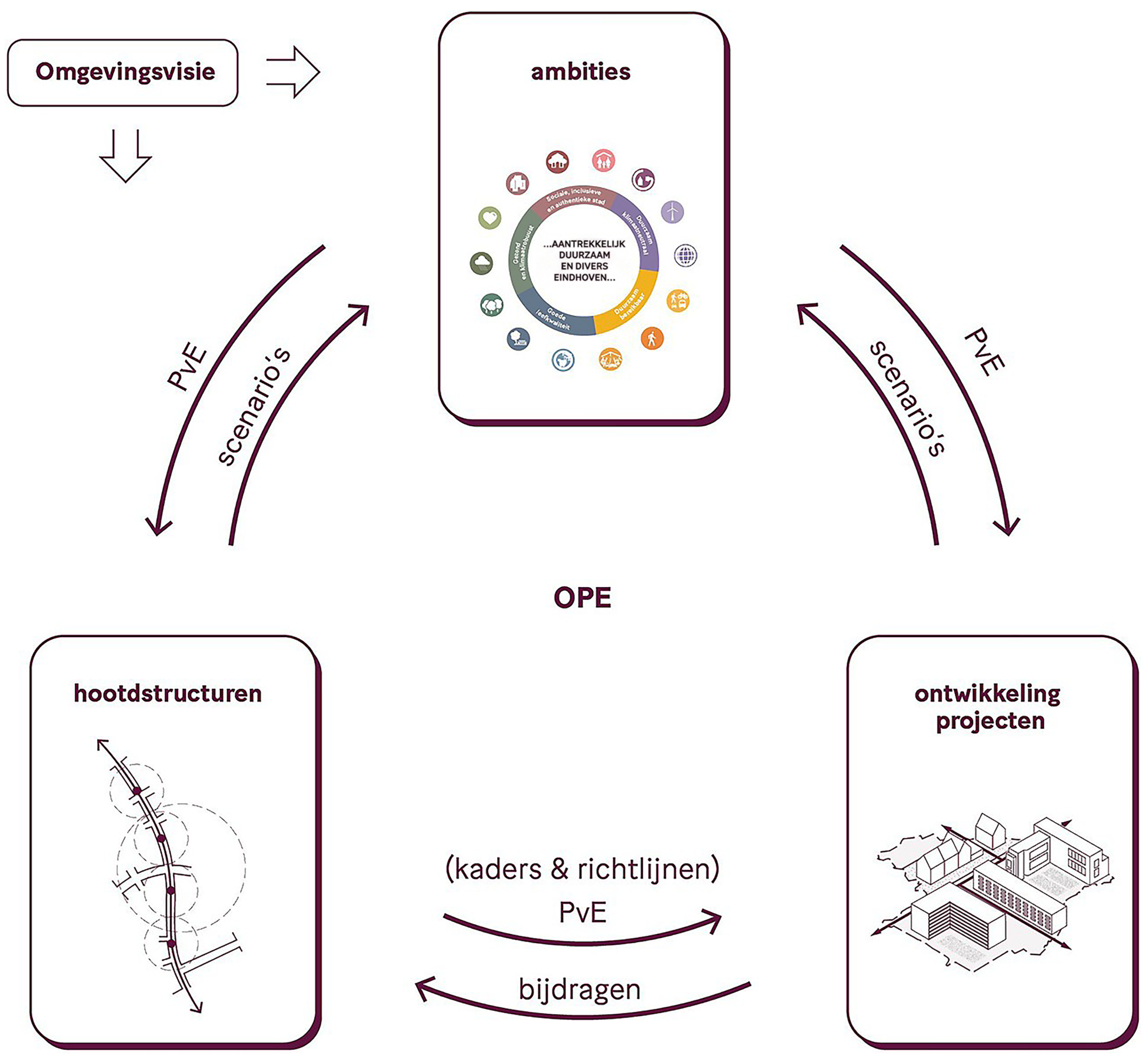
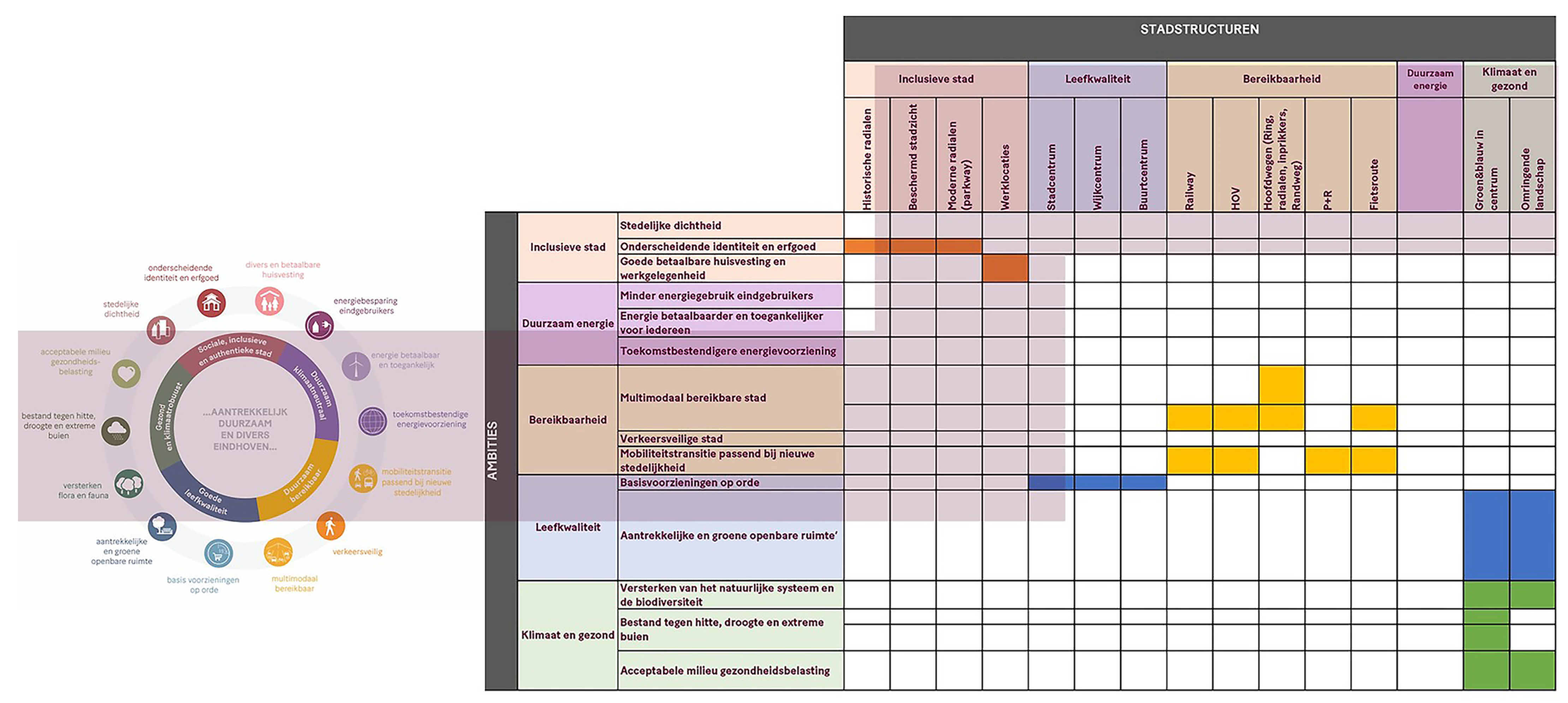
Its primary function is to translate abstract policy ambitions into structured evaluative criteria that support comparison, prioritisation, and collective decision-making, rather than to prescribe specific design solutions. This process is illustrated in
Figure 1 and
Figure 2.
3.2.2. Modelling Logic and Translation of Ambitions
The modelling process followed a two-step imperative logic. First, the existing urban situation—land use, built form, infrastructure, regulations, and environmental conditions—was analysed and spatialised. Second, municipal ambitions articulated in the Environmental Vision were translated into Key Performance Indicators (KPIs) that could be quantified and mapped. For example, the ambition of fostering a “social, inclusive, and authentic city” was decomposed into sub-goals such as urban density, accessibility, and programmatic diversity.
These sub-goals were operationalised through indicators including Floor Space Index (FSI), proximity to public transport, and access to amenities. Each KPI was spatialised using influence zones, where proximity to key urban structures (such as train stations, commercial centres, or green spaces) affected target values. A deliberate modelling decision was the imposition of KPIs onto a uniform 100 × 100 m grid. Rather than anchoring evaluation to predefined project boundaries, the grid enabled continuous spatial comparison across the city. This aligns with imperative CIM logic by prioritising consistency, comparability, and evaluative clarity across heterogeneous urban areas.
By comparing current KPI values with ambition-driven target values, the model generated delta maps highlighting spatial discrepancies. These deltas did not prescribe solutions directly; instead, they structured collective understanding of where interventions were most urgently required and where ambitions and existing conditions diverged. In methodological terms, this workflow linked policy interpretation, indicator construction, spatial discretisation, and evaluative comparison within a single imperative modelling pipeline.
3.2.3. Methodological Approach
The Eindhoven Digital Twin was constructed through a structured pipeline integrating spatial base data, regulatory frameworks, and policy-defined ambitions.
Input data included cadastral information, land-use classifications, building footprints, floor area ratios, public transport networks, amenity locations, and environmental constraints. These datasets were harmonised within a GIS environment and projected onto a uniform 100 × 100 m grid, which served as the common unit of spatial comparison across the municipality.
The translation of municipal ambitions into KPIs followed a two-stage process. First, qualitative policy objectives were disaggregated into measurable sub-goals through iterative workshops with municipal planners. Second, each sub-goal was operationalised as a spatial indicator using proximity analysis, density metrics, or threshold-based criteria. Indicators were maintained as separate evaluative dimensions rather than aggregated into a composite index in order to preserve interpretability and avoid over-aggregation.
The principal outputs of the model were spatialised KPI fields and delta maps comparing current values with ambition-driven target values. Thresholds were defined on the basis of planning documents and regulatory benchmarks rather than statistical optimisation. Validation occurred through iterative stakeholder workshops, during which modelled discrepancies were assessed for plausibility and for alignment with stated policy intentions.
For traceability, each KPI was linked to a specific policy ambition, operational definition, spatial calculation method, and reference threshold derived from municipal planning documents or regulatory benchmarks. The model therefore preserved indicator layers as separately interpretable evaluative dimensions rather than collapsing them into a single aggregate score. Review sessions with municipal planners were used to check indicator definitions, threshold choices, and resulting spatial discrepancies for policy consistency and spatial plausibility.
3.2.4. Collective Insight Generation and Boundary-Object Function
The Eindhoven Digital Twin functioned as a boundary object by providing a shared evaluative framework through which municipal departments, external consultants, and decision-makers could engage collectively.
Rather than relying on narrative interpretation alone, discussions were anchored in spatialised KPI values that made trade-offs explicit.
In this context, collective insight generation emerged not from the model autonomously, but from the interaction between stakeholders and the evaluative structure imposed by the model.
The imperative logic of the Digital Twin stabilised complexity by narrowing the field of discussion toward measurable discrepancies, priorities, and conflicts between ambitions.
At the same time, this logic imposed constraints. Phenomena that resisted quantification or fell outside predefined KPIs were necessarily backgrounded.
While this limitation is inherent to imperative modelling, it was acceptable within the Eindhoven context, where the primary demand was for actionable and justifiable decisions aligned with formal policy frameworks.
3.2.5. Operationalisation of the Imperative Mode
According to the analytical framework established in
Table 1, the Eindhoven Digital Twin exemplifies the imperative mode of UDT within CIM.
At the epistemic level, the model is oriented toward determination and decision support. Municipal ambitions articulated in the Environmental Vision are translated into quantifiable Key Performance Indicators (KPIs), enabling measurable comparison between current conditions and target states and thereby stabilising complexity toward resolution. Methodologically, this imperative stance is realised through indicator decomposition and spatial discretisation. Complex urban ambitions are operationalised through specific metrics—such as density, accessibility, and programmatic diversity—and projected onto a uniform spatial grid. In this way, complexity is reduced into evaluative fields that support comparability, benchmarking, and prioritisation.
The resulting output form follows the logic of performance evaluation. Spatialised KPI fields and delta maps do not preserve ambiguity; instead, they foreground measurable gaps and trade-offs that guide negotiation and intervention.
Uncertainty is handled through explicit criteria and thresholds. Rather than retaining ambiguity, the modelling logic narrows interpretive space in order to support accountability and structured negotiation. As a boundary object, the Digital Twin stabilises collective cognition around shared evaluative metrics. Insight generation emerges through interaction with the KPI framework, reinforcing the governance alignment characteristic of imperative UDT.
Taken together, these features show how the Eindhoven case operationalises the imperative mode through a traceable linkage between policy ambition, indicator construction, spatial comparison, and collective evaluation.
3.3. The SADC Digital Twin: Imperative CIM Under Multi-Stakeholder Conditions
The SADC case extends the imperative logic examined in Eindhoven into a more institutionally heterogeneous setting. Here, the emphasis lies on how a shared evaluative platform can structure comparison and negotiation across multiple actors, competing ambitions, and overlapping constraints.
3.3.1. Context and Epistemic Challenge
The Schiphol Area Development Corporation (SADC) operates within one of the most complex spatial environments in the Netherlands. The EnterNL region adjacent to Schiphol Airport is characterised by overlapping jurisdictions, competing economic interests, strict environmental constraints, and significant national and international relevance.
Stakeholders include provincial authorities, multiple municipalities, national infrastructure agencies, private developers, and the Schiphol Group itself. In this context, planning is less about articulating a single vision and more about mediating between conflicting ambitions under regulatory, environmental, and infrastructural constraints.
This complexity generates a strong demand for imperative UDT. Stakeholders require transparent, comparable, and negotiable insights to support coordination, accountability, and justification across institutional boundaries.
3.3.2. Platform Architecture and Thematic Modules
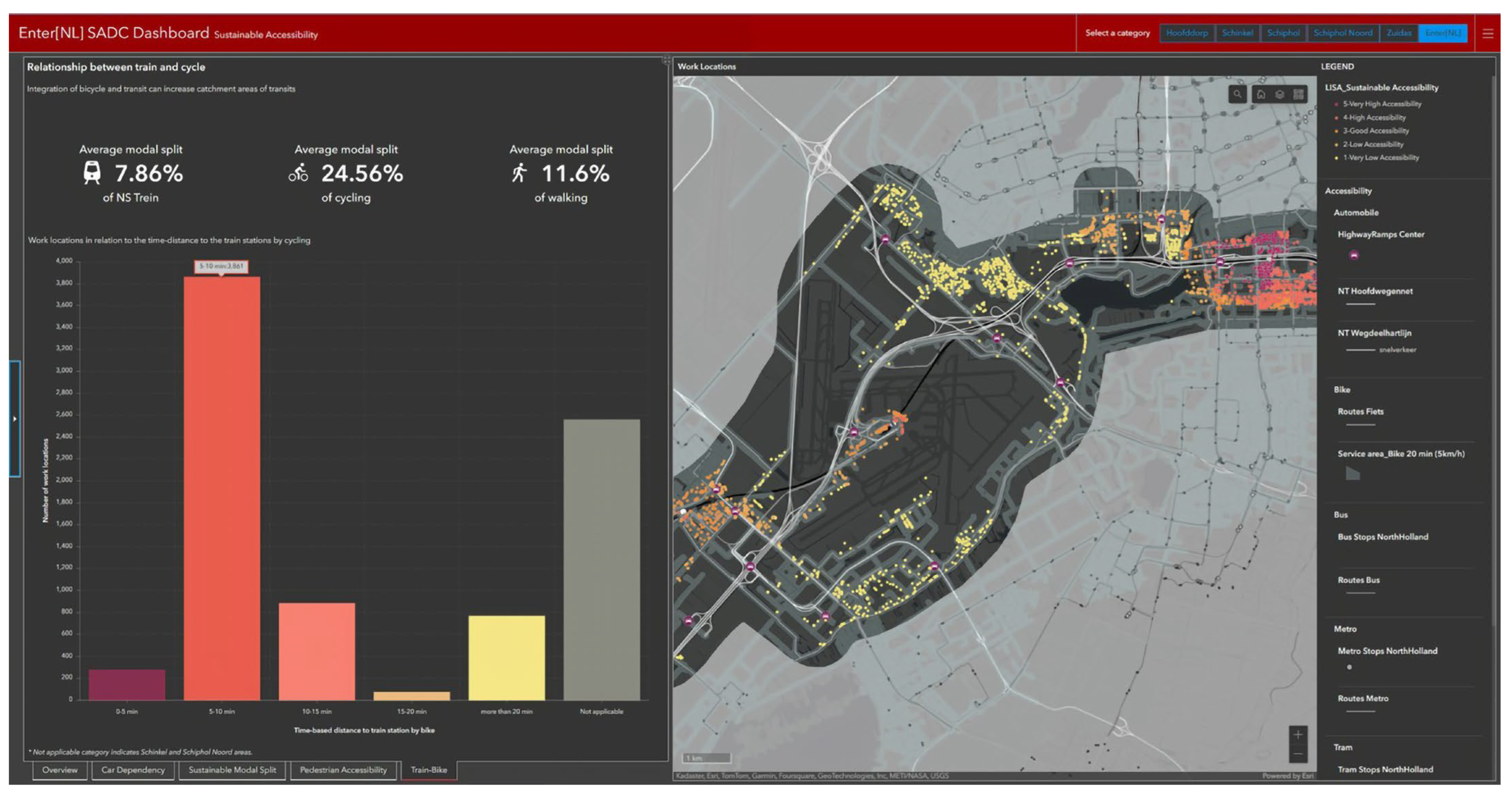
The SADC Digital Twin was conceived as a modular platform composed of several interrelated components. At its core lies a shared spatial data bank, providing a single source of information accessible to all stakeholders, as shown in
Figure 3. On top of this foundation, thematic modules were developed to address specific planning questions, including sustainable accessibility, financial feasibility, well-being, and ecological performance. Each module translated abstract ambitions—such as alignment with the United Nations Sustainable Development Goals—into spatially explicit indicators. For example, the Sustainable Accessibility module compared car-based and public-transport-based accessibility of employment locations, enabling evaluation of mobility scenarios in relation to sustainability objectives.
This modular structure reflects imperative CIM logic: complexity is decomposed into thematic dimensions that can be evaluated separately, while remaining comparable within a shared informational framework.
3.3.3. Methodological Transparency
The SADC Digital Twin was developed as a modular architecture built upon a shared spatial data repository. Input data included cadastral records, infrastructure networks, environmental zoning, mobility flows, employment data, and sustainability indicators derived from national and European policy frameworks. These datasets were integrated within a common spatial data bank that functioned as the shared informational basis for all thematic modules.
Each module was then constructed using dimension-specific indicator sets. For example, the Sustainable Accessibility module employed multimodal travel time analysis and catchment modelling to compare car-based and public-transport accessibility under alternative scenarios, while the ecological performance module utilised spatial overlays of environmental protection zones, emission thresholds, and biodiversity indicators.
Indicators were maintained as separate evaluative dimensions rather than aggregated into a single composite score. The principal outputs of the model were comparative dashboards and side-by-side scenario assessments benchmarked against predefined sustainability and development targets. For methodological traceability, each thematic module was documented in terms of its input datasets, indicator logic, comparison procedure, and planning relevance.
Validation took place through inter-institutional review sessions involving provincial authorities, municipal representatives, and development stakeholders and focused both on the technical plausibility of outputs and on whether the modules represented the planning question consistently and transparently.
3.3.4. Imperative Evaluation and Negotiation
The imperative nature of the SADC Digital Twin is evident in its emphasis on comparative evaluation. Scenarios were assessed against predefined indicators, allowing stakeholders to identify spatial configurations that performed better or worse relative to agreed criteria. This evaluative structure enabled negotiation by grounding discussions in shared metrics rather than rhetorical positions alone.
As in the Eindhoven case, the Digital Twin did not make decisions autonomously. Instead, it structured the conditions under which decisions could be discussed collectively. By making conflicts between ambitions visible—such as tensions between economic development and environmental constraints—the platform supported informed negotiation among heterogeneous actors.
However, the SADC case also highlights the epistemic limits of imperative modelling. Not all stakeholder concerns could be fully captured through KPIs, and tensions occasionally emerged when model outputs conflicted with experiential, political, or tacit forms of knowledge. These moments underscore the importance of recognising imperative UDTs as epistemic instruments rather than neutral arbiters of truth [
15].
3.3.5. Operationalisation of the Imperative Mode Under Multi-Stakeholder Conditions
According to the analytical framework established in
Table 1, the SADC Digital Twin operationalises the imperative mode under heightened institutional and stakeholder complexity.
At the epistemic level, the model is oriented toward evaluative comparison across competing ambitions. The modular platform translates sustainability goals, accessibility targets, and economic objectives into spatially explicit indicators, enabling scenario benchmarking and structured negotiation across institutional boundaries.
Methodologically, this imperative stance is realised through thematic decomposition. Complexity is partitioned into modules—such as sustainable accessibility, well-being, ecological performance, and financial feasibility—each expressed through measurable criteria. This reduces systemic complexity into comparable evaluative dimensions while maintaining a shared informational basis across the platform.
The resulting output form consists of comparative dashboards and scenario assessments that allow stakeholders to evaluate alternative spatial configurations relative to predefined performance targets. As in the Eindhoven case, ambiguity is narrowed rather than preserved in order to support accountability and decision legitimacy.
Uncertainty is managed through predefined indicators, benchmarks, and review procedures. This does not eliminate disagreement, but it structures negotiation within an agreed evaluative frame.
As a boundary object, the Digital Twin anchors negotiation in shared metrics. Trade-offs between environmental constraints and development ambitions become visible within a common evaluative structure, reinforcing the imperative alignment with regulatory and governance processes.
At the same time, the case also reveals a characteristic epistemic risk of imperative modelling: concerns that resist quantification may be marginalised. The SADC case therefore illustrates both the strength and the limitation of imperative UDT within CIM.
4. Declarative Urban Digital Twinning: The Graz Case Study
The preceding Dutch cases established how UDTs can operate within CIM as imperative, evaluation-oriented instruments that support structured comparison, negotiation, and decision-making. The present section shifts the focus from determination to articulation by examining a declarative mode of twinning in which the primary task is not to benchmark performance, but to render latent urban relations perceptible under conditions of uncertainty. The Graz case is introduced not as an alternative hierarchy of value, but as a complementary epistemic configuration through which the comparative framework developed in this paper can be extended.
4.1. From Determination to Articulation: Positioning the Graz Case
The Dutch case studies demonstrated how imperative UDTs, operating within CIM, can effectively support collective insight generation under conditions of structured governance, evaluative clarity, and well-defined policy ambitions. Their strength lies in stabilising complexity toward determination through KPI-driven and multi-criteria frameworks. At the same time,
Section 3 also revealed the epistemic limits of imperative modelling, particularly in contexts where ambiguity, long-term uncertainty, and poorly structured data resist reduction to determinate indicators.
The Graz case study is introduced precisely at this juncture. It does not aim to correct or replace imperative approaches, nor does it function as a counterexample. Instead, it explores a complementary mode of UDT: a declarative approach oriented toward sense articulation rather than resolution. In doing so, it extends the comparative framework advanced in this paper by demonstrating how UDTs can operate within CIM as processual forms of twinning based on reduced complex models, enabling collectively grounded interpretation under conditions where determination would be epistemically premature or misleading.
Crucially, the selection of Graz is not motivated by cultural or national comparison with the Netherlands. Rather, it reflects an epistemic opportunity: the presence of real urban challenges characterised by environmental complexity, fragmented data landscapes, and long-term transformation pressures, for which declarative modelling provides a productive mode of engagement.
4.2. Context: Environmental Urbanism and Epistemic Uncertainty
The Graz case forms part of the research project Environmental Urbanism Digital Architectonics, developed within an academic context but grounded in real urban conditions. The project responds to increasing pressure to engage environmental and socio-spatial dynamics within urban design and planning processes under conditions where relevant information is heterogeneous, temporally uneven, and only partially formalised.
In contrast to the Dutch cases discussed earlier, the Graz context is not primarily structured by strong institutional demand for KPI-driven decision-support systems.
Instead, it is characterised by fragmented governance arrangements, uneven data availability, and environmental concerns that are often articulated qualitatively rather than through predefined performance targets. Under these conditions, the challenge is not simply to evaluate alternatives against agreed criteria, but to render urban transformation dynamics perceptible in a form that can support interpretation.
For this reason, the study operationalises the broader problem field through four measurable dimensions: population count, population density, building footprint area and density, and carbon emissions from the built environment sector. These dimensions do not exhaust the complexity of the urban condition; rather, they provide a reduced yet structurally consistent basis for analysing transformation dynamics under epistemic uncertainty.
The Graz case therefore foregrounds a context in which environmental urbanism requires relational articulation before fixed evaluative criteria are imposed. This makes it a suitable setting for examining how declarative UDT can support interpretive urban reasoning without presupposing immediate decision-making.
4.3. Urban Digital Twin as a Process of Twinning
A central distinction in the Graz case lies in the status of the UDT itself. Whereas the Eindhoven and SADC Digital Twins were developed primarily as applications or platforms for evaluative decision support, the Graz case understands the UDT as a process of twinning.
In this sense, twinning does not refer to the synchronisation of a digital replica with real-time urban data. Rather, it denotes an ongoing epistemic operation through which a reduced complex model of urban dynamics is constructed, interrogated, and re-articulated over time.
The Digital Twin is therefore not treated as a fixed endpoint, but as a mediating process through which urban complexity becomes visible, discussable, and open to interpretation.
This processual understanding provides the basis for the methodological sequence that follows. Declarative twinning is realised not through a single evaluative model, but through successive operations of reduction, encoding, dimensional translation, and interpretive visualisation.
4.4. Reduction Without Simplification: Modelling Latent Urban Structures
As discussed in
Section 2, declarative modelling relies on reduction rather than simplification. In the Graz case, this principle is operationalised through reduced models designed to preserve relational complexity and latent structures across multiple urban dimensions.
Rather than collapsing these dimensions into composite indices or weighted scores, the modelling strategy maintains them as distinct but related informational layers. Reduction is achieved through spatial discretisation, dimensional translation, and pattern recognition.
A key methodological move in this process is the use of a uniform 1 km2 raster grid as the primary unit of analysis. The raster framework enables consistent spatial sampling across heterogeneous datasets and temporal slices, supports comparability across the national dataset, and allows continuous urban fields to be articulated rather than reduced to discrete project sites. Each cell functions as a micro-urban node in which multiple variables can be encoded simultaneously.
This approach does not seek to represent the city exhaustively. Instead, it constructs a reduced informational landscape in which latent structures—such as correlations, clusters, and discontinuities—can emerge and become available for interpretation.
4.5. Natural Communication as Declarative Modelling Methodology
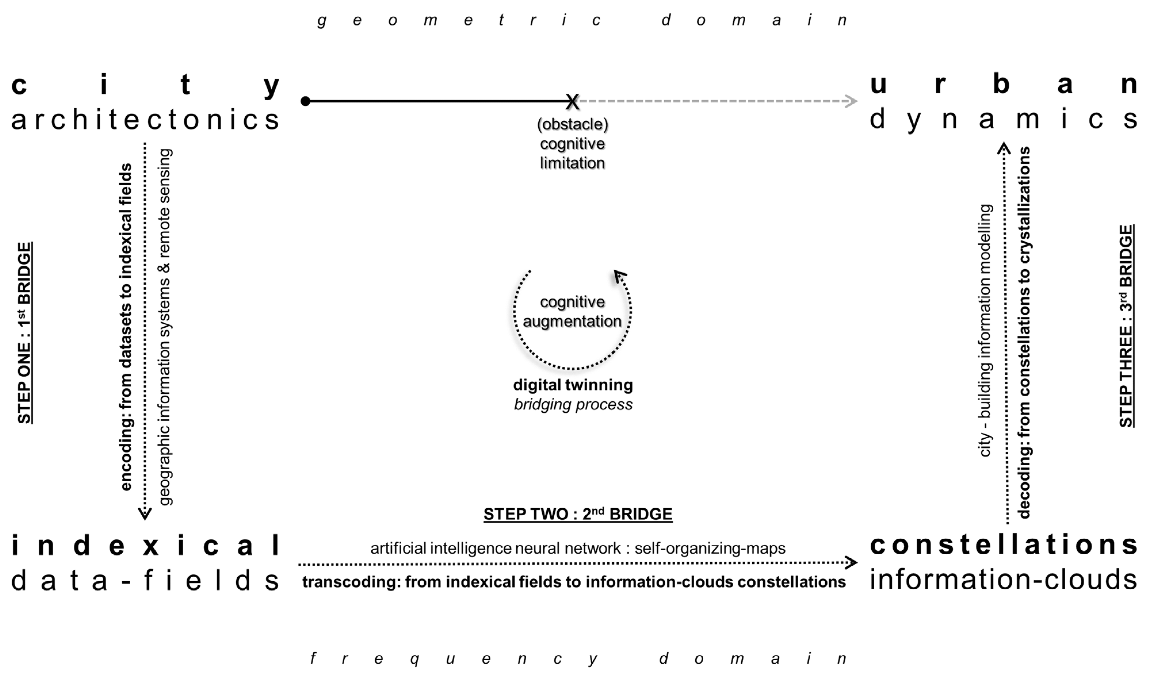
The declarative logic of the Graz twinning process (illustrated in
Figure 4) is grounded methodologically in Natural Communication theory [
11]. This theoretical basis is adopted here not as an abstract external overlay, but because it offers a formal way to preserve structural correspondences across heterogeneous urban datasets without reducing them prematurely to fixed evaluative criteria. In the Graz context, where environmental transformation must first be rendered perceptible under fragmented data conditions and epistemic uncertainty, this makes Natural Communication methodologically appropriate for declarative modelling.
This does not imply that Natural Communication is the only possible theoretical basis for declarative Urban Digital Twinning. Other complexity-oriented approaches can also inform relational urban modelling, including systems thinking and soft systems methodology [
16], network-based approaches to urban complexity [
17,
18], resilience thinking in social-ecological systems [
19,
20], and assemblage perspectives in urban studies [
21,
22,
23]. Natural Communication is used in the Graz case for a more specific reason: it provides an operational vocabulary for moving between representational domains through encoding, transcoding, and decoding, while preserving structural correspondences rather than converting heterogeneous variables into a single evaluative measure. Its relevance here therefore lies not in theoretical exclusivity, but in its methodological fit with the declarative aim of articulating latent relations under uncertainty.
Within this study, Natural Communication provides the formal methodological basis for engaging complexity through gnomonic reduction, enabling correspondences between different representational domains without enforcing direct equivalence. At its core lies a triadic process of encoding, transcoding, and decoding. Urban data are first encoded in geometric or metric form, then transcoded into relational or harmonic domains in which latent patterns can be articulated, and finally decoded back into architectural and urban reasoning contexts.
The methodological significance of this sequence lies not in translation toward a single correct answer, but in preserving structural correspondences while allowing dimensional reduction. Rather than optimising toward predefined outputs, the process supports sense articulation by making latent structures perceptible across domains. Noise is not treated as an error to be eliminated, but as a carrier of information that contributes to structural intelligibility.
4.6. Making Latencies Perceptible: Computational Techniques
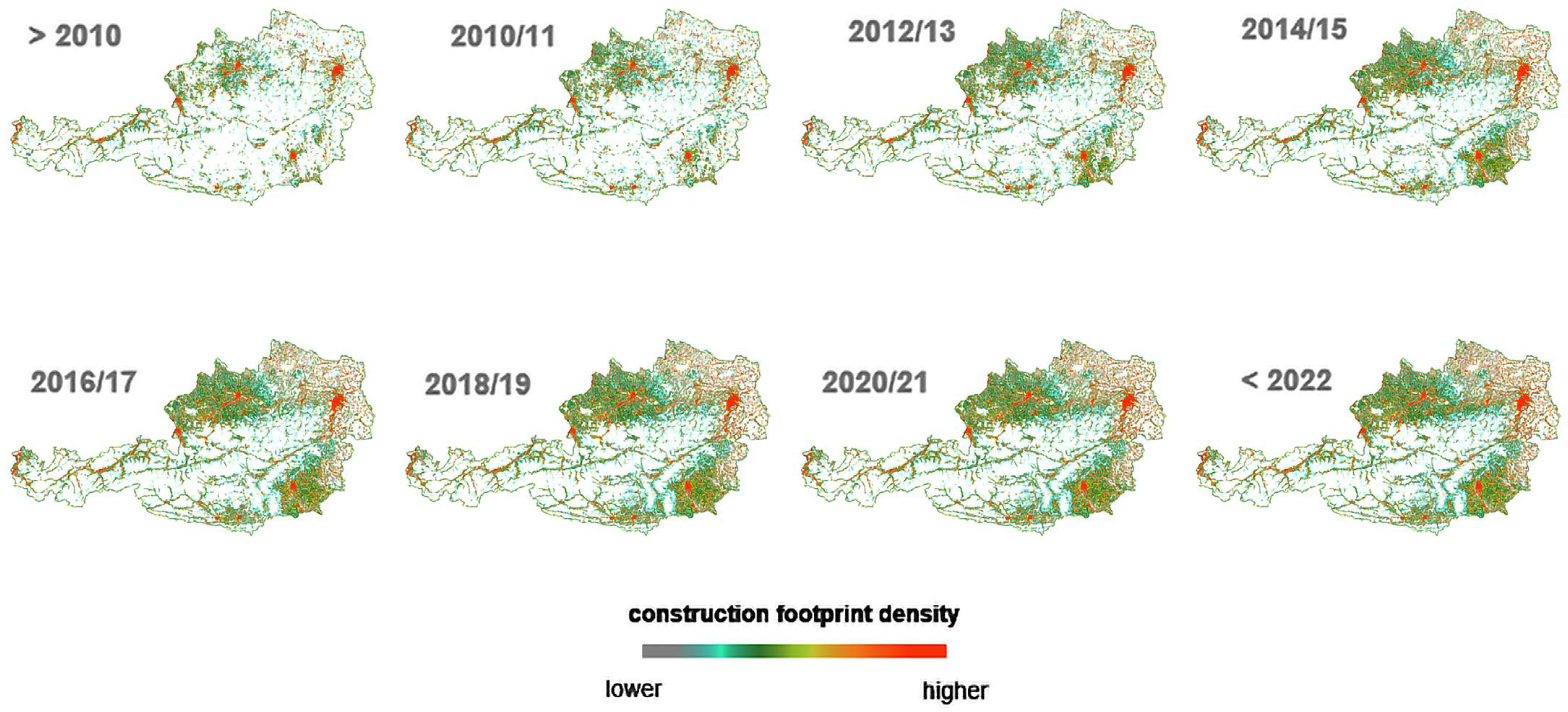
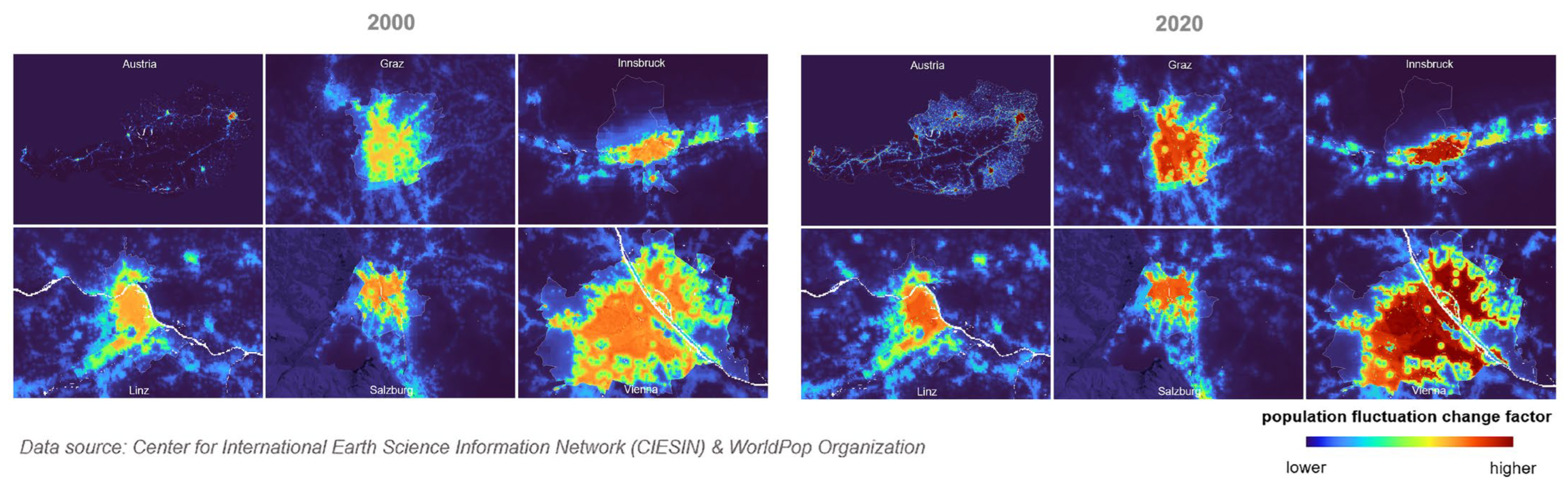
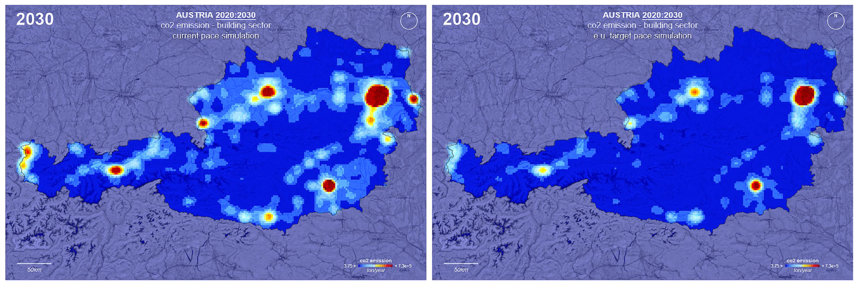
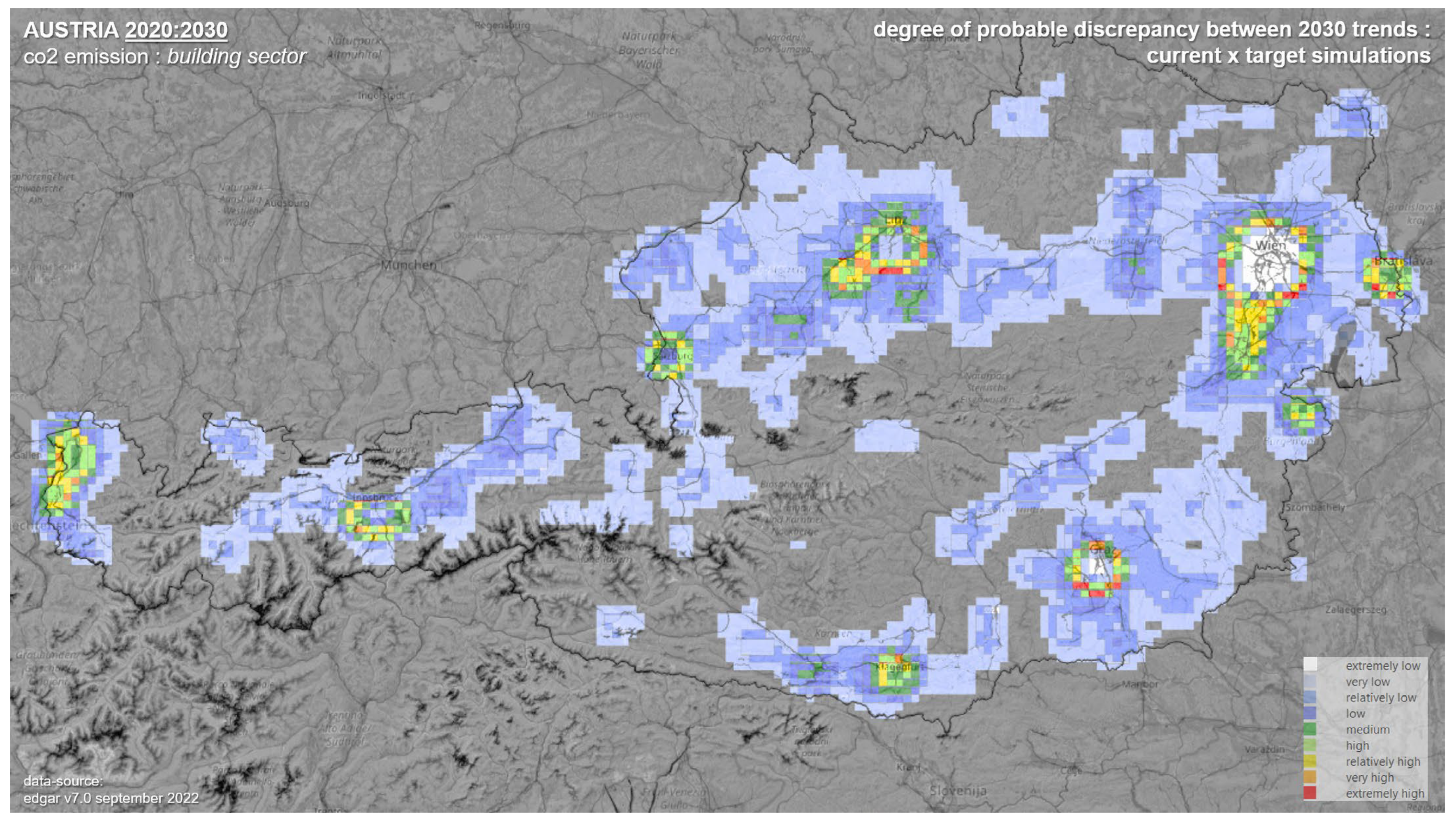
Although the methodological pipeline is demonstrated using Austria-wide datasets, the interpretive articulation is focused on the Graz urban context. National-scale encoding provides structural comparability across heterogeneous territorial conditions, while Graz serves as the focal site for examining transformation potentials within a specific metropolitan setting. This is shown in detail across
Figure 5,
Figure 6,
Figure 7 and
Figure 8.
This multi-scalar arrangement is consistent with declarative modelling logic, in which relational structures are detected across broader fields and subsequently interpreted at local levels.
In operational terms, the Graz case combines GIS-based spatial analysis, Self-Organising Maps (SOMs), and neural network techniques to articulate latent urban structures [
24,
25]. These techniques are not used to rank alternatives or produce predictive certainty, but to reveal patterns of correlation, clustering, and transformation across time and space.
Multi-temporal datasets are processed to identify recurring spatial configurations and shifts over time. These encoded layers include both demographic and built-environment dimensions; only the most representative stages of the encoding process are shown here for reasons of clarity. Once encoded into multi-variable feature vectors, the data are analysed using SOMs, which project high-dimensional relationships into reduced topological spaces in which similarities, gradients, and discontinuities between urban nodes become visually and analytically interpretable. Neural network techniques are then used to explore temporal transformation patterns between historical states and projected scenarios, not as deterministic forecasts but as indicators of structural tendencies and transformation potential.
Resulting visualisations function as interpretive artefacts through which latent relations become more accessible than they would in raw datasets alone.
4.7. Methodological Structure of Declarative Urban Digital Twinning
The Graz UDT process is structured around a multi-stage reduction pipeline designed to preserve relational complexity while enabling the interpretation of latent structures.
The input data consist of multi-temporal datasets organised around four primary dimensions: (1) population count, (2) population density, (3) building footprint area and density, and (4) carbon emissions from the built environment sector. Together, these variables provide a reduced yet consistent representation of demographic and built-environment dynamics relevant to the study.
Population datasets span 2000–2020, while built-environment and emission indicators were harmonised across 2010–2022 in order to establish a consistent 2010–2020 analytical window for exploring transformation patterns toward 2030. Because data availability differed across indicators, the 2030 scenarios are based on pattern extrapolation from the harmonised 2010–2020 series rather than on direct linear projection from 2000.
Data sources include OpenStreetMap (OSM) [
26], Microsoft Buildings datasets [
27], aerial imagery from European Space Agency (ESA) and NASA platforms [
28,
29], and emissions data from the EDGAR database [
30]. All variables are discretised onto a uniform 1 km
2 raster grid, which serves as the common spatial unit of analysis and ensures comparability across temporal datasets while avoiding artefacts introduced by inconsistent administrative or cadastral boundaries.
Rather than aggregating these variables into composite indices, they are retained as distinct feature vectors associated with each raster cell. This enables relational pattern detection through dimensional reduction rather than evaluative aggregation.
Dimensional translation is performed through Self-Organising Maps (SOMs), which project multidimensional relationships into lower-dimensional topological representations. The SOM does not optimise toward a predefined objective; instead, it organises spatial cells according to similarity patterns, enabling the detection of clusters, gradients, and discontinuities across time. Neural network techniques are then used to explore temporal transformation patterns between historical states and projected scenarios, not for predictive certainty but for identifying structural tendencies and transformation potential.
In operational terms, each raster cell was treated as a feature vector composed of the selected demographic, built-environment, and emissions variables for the harmonised temporal window. The Austria-wide encoding stage established a structurally comparable field, after which the Graz metropolitan area was interpreted as a focal subset within that broader relational landscape. Robustness was assessed by examining whether major cluster structures and transformation tendencies remained legible under variation in input combinations and temporal slices. Expert corroboration consisted of reviewing whether the resulting spatial patterns corresponded plausibly to known urban and environmental conditions rather than arising from obvious data artefacts or unstable model behaviour.
Validation in the declarative mode differs from imperative benchmarking. Instead of comparing outputs to predefined targets, it assesses pattern stability across temporal slices, the consistency of cluster structures under variable perturbation, cross-domain resonance between environmental and morphological indicators, and interpretive corroboration through expert review and spatial plausibility assessment. The objective is not to minimise uncertainty but to ensure that emergent patterns are structurally meaningful rather than artefacts of noise or overfitting.
4.8. Collective Interpretation Within a Shared Perceptual Field
As with imperative UDTs, the Graz Digital Twin operates as a boundary object. However, the collective engagement it enables differs in kind. Rather than aligning actors around shared evaluative criteria, the declarative Digital Twin provides a shared perceptual field within which informed interpretation can be collectively articulated.
Interpretations emerge through dialogue among researchers, designers, and planners who engage with the topological structures made perceptible by the twinning process. The Digital Twin organises the conditions under which structural correspondences, discontinuities, and transformation tendencies can be discussed.
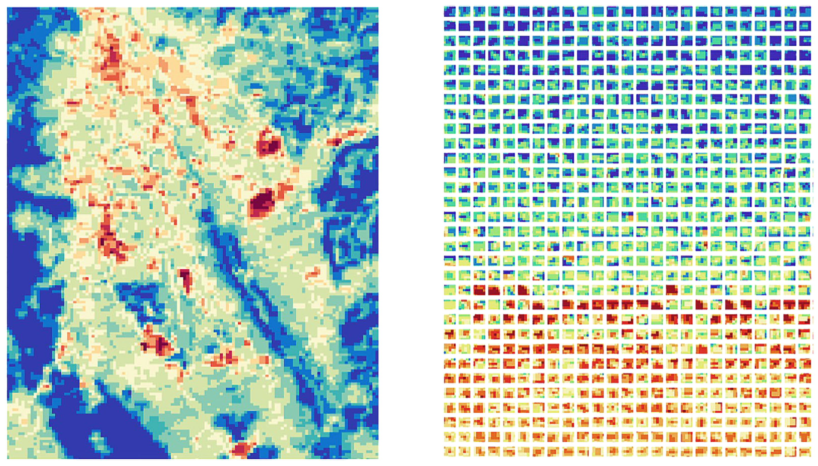
The geolinked SOM visualisation shown in
Figure 9 does not rank spatial cells. Instead, it relates their geographic distribution to a reduced topological organisation based on similarity in multidimensional feature space, so that corresponding magnitudes, gradients, and cluster relations can be interpreted across both views. This makes transformation patterns across time more legible and available for collective interpretation. In this way, declarative twinning supports shared interpretive engagement under conditions in which fixed evaluative criteria would be premature.
Taken together, the declarative workflow links data encoding, relational translation, geolinked visualisation, and collective interpretation within a continuous process of twinning.
4.9. Limits and Affordances of Declarative Urban Digital Twinning
Declarative twinning is not universally applicable. Its openness can appear as a limitation in contexts that demand immediate decisions, regulatory compliance, or formal accountability. Declarative models require time, interpretive capacity, and institutional willingness to engage ambiguity without converting it too quickly into fixed evaluative criteria.
Those same characteristics, however, constitute their primary affordance. By resisting reduction to determinate outcomes, declarative Digital Twins preserve the possibility of re-articulation as conditions change and as new relations become perceptible. They enable engagement with complexity without collapsing it into false certainty.
Within CIM, the value of declarative twinning lies in addressing interpretive demands that cannot be satisfied through evaluation alone. Its role is strongest where the task is to render latent conditions intelligible before they are translated into performance targets, planning priorities, or design interventions.
In practical terms, declarative twinning is most useful where the problem frame is not yet sufficiently stabilised for KPI-driven evaluation. This includes early-stage strategic planning, long-term environmental transition questions, and contexts in which heterogeneous datasets must first be interpreted before formal criteria can be agreed upon. In such settings, declarative twinning helps planners, designers, and public actors identify latent spatial relations, transformation tendencies, and areas requiring further inquiry, thereby clarifying how the problem should be framed and what may later count as a relevant evaluative criterion.
In this sense, the Graz case should be understood as a pre-decisional planning interface rather than as a formal decision-support platform. Its outputs are not intended to approve, reject, or rank planning alternatives directly. Instead, they support earlier stages in which relevant spatial relations, environmental pressures, and transformation sensitivities must first be made visible and discussable.
The interaction with planning practice therefore occurs through problem framing, agenda setting, and the preparation of later evaluative criteria. Pattern fields, similarity clusters, and transformation-potential maps can help identify where further investigation is required, which areas may demand more detailed environmental assessment, and how subsequent KPI-based or scenario-based models might be structured. This positions declarative twinning as a bridge between exploratory interpretation and later decision-oriented modelling, rather than as a substitute for regulatory evaluation.
Its practical relevance therefore lies not in producing an immediate ranked decision, but in supporting the interpretive work that precedes formal evaluation: establishing a more robust basis for subsequent problem definition, enabling more grounded transitions into evaluative or projective forms of modelling, and guiding targeted inquiry within later planning processes.
4.10. Operationalisation of the Declarative Mode
According to the analytical framework established in
Table 1, the Graz case operationalises the declarative mode of UDT within CIM. At the epistemic level, the model is oriented toward articulation rather than determination.
Methodologically, this declarative stance is realised through raster-based encoding, dimensional reduction, and relational visualisation of distinct feature vectors. Rather than aggregating variables into a single evaluative outcome, the process preserves structural correspondences, gradients, and discontinuities across the modelled field.
The resulting output form consists of pattern fields, similarity clusters, and transformation potentials. These visualisations function as relational outputs within the declarative framework, making structural tendencies available for further interpretation without reducing them to thresholds or optimised targets. Uncertainty is retained as informative, with variability contributing to structural intelligibility rather than being closed down through optimisation. As a boundary object, the Graz Digital Twin stabilises a shared perceptual field rather than shared evaluative criteria. Collective cognition emerges through dialogue around the patterns rendered visible by the model, allowing the case to support urban reasoning under conditions of ambiguity.
Overall, these characteristics show how the Graz case instantiates the declarative mode through a traceable linkage between reduced complex modelling, relational visualisation, and collective interpretation.
5. Comparative Discussion: Imperative and Declarative Urban Digital Twins Within City Information Modelling
To consolidate the analytical comparison developed across
Section 3 and
Section 4,
Table 2 summarises the three case studies according to the framework introduced in
Table 1.
The table should be read not as an empirical ranking of cases, but as a synthesis of their modelling orientations. It shows how the Dutch cases stabilise complexity through indicator-based evaluation and stakeholder negotiation, while the Graz case preserves relational complexity through reduced modelling, pattern detection, and interpretive visualisation.
The comparison is organised around data sources, spatial units, transformation procedures, output forms, uncertainty treatment, validation logic, and planning use, so that the analytical differences between imperative and declarative twinning become explicit.
5.1. From Case Specificity to Epistemic Comparison
The preceding sections examined imperative and declarative UDT through three concrete cases situated in different planning and research contexts.
The comparison advanced here is not organised around national context as such, but around how different twinning orientations become operationally visible across the three cases.
The Eindhoven and SADC cases foreground determination-oriented modelling, whereas the Graz case foregrounds interpretation-oriented modelling within a contrasting planning condition.
The comparative discussion that follows is structured through the analytical criteria established in
Table 1. This makes it possible to compare the cases not only as project-specific applications, but also as distinct epistemic configurations within a shared CIM perspective.
On that basis, the section clarifies their respective roles, limitations, and practical complementarity in urban planning and design.
5.2. Imperative and Declarative Modes as Epistemic Orientations
Across the three cases, the main difference lies not in technical sophistication but in modelling orientation. The Dutch cases reduce complexity into evaluative structures that support comparison and decision, whereas the Graz case reduces complexity into relational configurations that support exploratory understanding under conditions in which fixed criteria would be premature. The contrast is therefore not between incompatible model types, but between different ways of making urban complexity usable in practice.
5.3. Boundary Objects and Collective Cognition in Both Modes
The comparative analysis shows that both imperative and declarative UDTs operate as boundary objects in distinct ways. In both modes, the Digital Twin provides a shared informational reference that enables cooperation among heterogeneous actors without requiring full epistemic consensus [
12].
In imperative modes, the boundary-object function is realised through shared evaluative criteria. KPIs, spatial metrics, and comparative dashboards provide a common language through which stakeholders can negotiate priorities, justify decisions, and align actions. The boundary object stabilises meaning around performance, making disagreements explicit and negotiable within an agreed evaluative frame.
In declarative modes, the boundary-object function is realised through shared perceptual fields. Reduced complex models, pattern visualisations, and relational mappings provide a common ground for interpretation without enforcing closure. Here, the boundary object does not stabilise meaning toward decision, but toward collective sense-making, allowing multiple interpretations to coexist and be articulated through dialogue.
5.4. Reduction Strategies and the Treatment of Complexity
The comparison also highlights fundamentally different strategies of reduction. Imperative UDTs reduce complexity by translating it into measurable indicators that can be aggregated, compared, and optimised. This form of reduction is effective when objectives are clearly articulated and when decision-making requires accountability, justification, and traceability.
In the Dutch imperative cases, spatial discretisation is used primarily to support KPI comparability. In the Graz declarative case, raster discretisation functions instead as a common encoding substrate through which relational patterns can be detected without being reduced to evaluative benchmarking.
Declarative UDTs reduce complexity by translating it into relational and structural representations that preserve ambiguity, latency, and potentiality. This form of reduction avoids premature simplification and enables engagement with complexity that would otherwise remain inaccessible within evaluative frameworks.
When applied outside their appropriate domain, both strategies can produce problematic outcomes. Imperative models risk false certainty when used in contexts characterised by deep uncertainty or poorly structured problems. Declarative models risk institutional friction when applied in contexts that demand immediate decisions and formal accountability.
It is important to note that validation operates differently across the two modes. In imperative UDTs, validation is primarily target-oriented: indicators are assessed against predefined thresholds and policy benchmarks. In declarative UDTs, validation is structural and interpretive: the stability, coherence, and cross-domain resonance of emergent patterns are assessed to ensure that relational configurations are not artefacts of model construction. Recognising this difference prevents the inappropriate application of evaluative standards across epistemically distinct modelling orientations.
5.5. Misapplication and Epistemic Risk
One of the central implications of this comparative framework is the recognition of epistemic risk associated with misapplication. The increasing popularity of UDTs has led to their deployment across a wide range of contexts, often without sufficient consideration of underlying modelling assumptions and epistemic orientation.
Applying imperative UDTs in exploratory or early-stage contexts can lead to over-rapid evaluation, masking uncertainty behind spurious precision. Conversely, deploying declarative UDTs in contexts that require immediate decisions can be perceived as evasive, insufficiently actionable, or institutionally incompatible.
CIM provides a framework within which such risks can be mitigated by making modelling orientations explicit. By recognising imperative and declarative modes as distinct but compatible operations within CIM, planners and designers can select or combine approaches in ways that are appropriate to the task at hand.
5.6. Complementarity Rather than Hierarchy
The comparative analysis shows that imperative and declarative UDTs are best understood as complementary modes of operation within CIM, each becoming productive under different institutional and planning conditions.
Imperative modes are most effective where objectives are clearly defined, performance must be demonstrated, and decisions require justification through explicit criteria. Declarative modes are most effective where objectives remain evolving or contested, and where urban complexity must first be rendered intelligible before it can be evaluated.
In practice, urban planning and design processes often require movement between these modes over time. Declarative modelling can support early-stage understanding where the planning problem remains open, contested, or insufficiently structured for KPI-driven evaluation. In such contexts, its role is to help actors identify relevant relations, sensitivities, and problem framings before formal criteria are stabilised. Imperative modelling can then translate selected concerns into indicators, thresholds, and scenarios that support prioritisation, negotiation, and decision. CIM provides the informational continuity that allows movement between interpretation and evaluation without treating them as disconnected modelling worlds.
This complementarity is important because neither mode is sufficient for all stages of urban reasoning. Declarative twinning can prevent premature closure by widening the field of interpretation, while imperative twinning can later support accountability by narrowing that field into explicit evaluative structures. Their relation should therefore be understood as sequential and recursive rather than hierarchical: planning processes may move from declarative articulation to imperative evaluation, but they may also return to declarative inquiry when new uncertainties, conflicts, or latent relations emerge.
5.7. Implications for CIM Theory and Practice
By articulating imperative and declarative modes explicitly, this paper contributes to a more nuanced understanding of CIM as a plural framework rather than a monolithic system. CIM does not prescribe a single modelling logic; it accommodates multiple epistemic orientations that can be mobilised according to context and connected over time.
This plurality has important implications for CIM theory and practice. It suggests that future developments in urban digital modelling should focus less on technological integration alone and more on conceptual alignment, ensuring that modelling approaches are matched to the cognitive, organisational, and temporal demands of planning situations.
For practice, this means that the value of a UDT should not be judged only by the volume of integrated data, the realism of simulation, or the sophistication of visualisation. It should also be judged by whether its modelling logic is appropriate to the task at hand: whether the situation calls for evaluative comparison, exploratory interpretation, or a structured transition between the two.
5.8. Transition to Governance and Institutional Considerations
The comparative discussion clarifies the epistemic roles of imperative and declarative UDTs within CIM. However, the adoption of these modes is not merely a technical or methodological matter. It also raises questions of governance, institutional readiness, and professional practice. The following section therefore examines the governance and institutional implications of adopting plural modes of UDT, with particular attention to organisational roles, competencies, and the cultural shifts required to support declarative approaches alongside established imperative practices.
6. Governance and Institutional Implications of Plural Urban Digital Twinning
This section shifts the focus from comparative analysis to the institutional conditions under which different twinning modes become usable, legitimate, and actionable. It examines how the coexistence of modelling pluralities affects governance arrangements, professional roles, and the organisational capacity to move between interpretation and decision.
6.1. From Epistemic Plurality to Institutional Consequence
Existing planning institutions are not equally prepared to accommodate both twinning modes. Because most governance arrangements are organised around evaluation, accountability, and procedural closure, imperative UDTs align more readily with prevailing institutional expectations than declarative ones. For declarative twinning to become institutionally usable, planning organisations must also recognise interpretive and pre-decisional modelling as legitimate planning work, rather than treating value only as the production of immediately actionable indicators.
Urban planning institutions have historically evolved around determination-oriented practices. Regulatory instruments, approval procedures, and accountability mechanisms are largely designed to support evaluative comparison, justification, and resolution. Imperative UDTs align readily with these structures, as they translate complexity into metrics and insights that can be audited, communicated, and defended.
Declarative UDT, by contrast, challenges many of these institutional expectations. Its emphasis on interpretation, latency, and non-determinacy raises questions about responsibility, legitimacy, and professional roles. Addressing these questions is essential if CIM is to support not only optimisation-driven planning, but also long-term urban and environmental reasoning under conditions of uncertainty.
6.2. Imperative Urban Digital Twins and Institutional Alignment
Imperative UDTs fit comfortably within contemporary planning governance. Their evaluative orientation supports transparency through explicit criteria, accountability through measurable outcomes, and procedural legitimacy through traceable decision pathways.
In the Dutch cases discussed earlier, imperative UDTs functioned as institutional mediators. By translating policy ambitions into KPIs and spatial metrics, they enabled coordination across municipal departments, facilitated negotiation among stakeholders, and supported formal decision-making processes. Their outputs could be documented, compared, and referenced in planning approvals, development agreements, and political deliberations.
This institutional compatibility partly explains the rapid uptake of UDTs in contexts aligned with performance-based planning and smart city agendas. Imperative UDTs reinforce existing governance logics by extending evaluative capacity without fundamentally challenging decision-making paradigms.
At the same time, this alignment introduces epistemic risk. When imperative modelling becomes the default mode, there is a tendency to privilege what can be measured over what can be meaningfully interpreted. Urban phenomena that resist quantification—such as emergent socio-spatial practices or long-term environmental feedbacks—may be marginalised not because they are unimportant, but because they are institutionally inconvenient.
6.3. Declarative Urban Digital Twinning and Institutional Tension
Declarative UDT introduces a different set of institutional dynamics. By prioritising sense articulation over resolution, declarative approaches resist immediate closure and challenge expectations of direct applicability. This resistance can generate institutional tension, particularly in governance environments oriented toward short-term decision cycles and regulatory compliance.
Declarative UDTs do not produce ready-made answers. Instead, they generate conditions for informed interpretation, which must be articulated collectively by engaged agents. Responsibility is therefore distributed rather than centralised, and outcomes remain open-ended. From an institutional perspective, this raises concerns regarding decision authority, accountability, and the legitimacy of interpretive processes.
These tensions should not be understood as deficiencies. Rather, they expose a misalignment between governance structures and the interpretive demands of complex urban problems. Systems characterised by non-linearity, emergence, and long-term transformation cannot be governed effectively through optimisation alone. Declarative UDT makes this limitation explicit by foregrounding interpretation as a necessary precursor to responsible action.
6.4. Shifting Professional Roles and Competencies
The adoption of plural UDT modes within CIM has significant implications for professional roles and competencies. Imperative UDTs tend to reinforce established expert roles, where planners, analysts, and engineers define criteria, calibrate models, and interpret results within relatively stable disciplinary boundaries.
Declarative UDT, by contrast, requires different forms of expertise. These include the ability to curate and reduce complex datasets without simplifying them, competence in interpreting latent patterns and relational structures, and facilitation skills for collective sense-making processes.
In this context, the role of the modeller shifts from problem-solver to epistemic mediator. Rather than delivering determinate answers, the modeller designs and maintains the conditions under which interpretation can occur. This shift reframes modelling as a form of architectural and urban reasoning, rather than as a purely technical activity.
6.5. City Information Modelling as a Governance Infrastructure
Understanding CIM as a plural framework for UDT suggests a rethinking of its role in governance. Rather than being treated as a technical toolset, CIM can be understood as an informational infrastructure that supports multiple modes of urban reasoning.
Within this perspective, CIM matters institutionally because it can hold different modelling outputs within a common informational environment. Its governance value lies less in privileging one mode over another than in enabling organisations to recognise when different forms of modelling are needed and to coordinate them coherently.
This perspective reframes governance challenges not as barriers to declarative approaches, but as design problems in their own right. Institutional frameworks themselves must be capable of accommodating epistemic plurality, allowing different modes of UDT to coexist and inform one another.
6.6. Risk, Responsibility, and Epistemic Humility
A final governance implication concerns the notion of responsibility. Imperative UDTs often project an aura of certainty that can obscure the assumptions and reductions embedded in their models. Declarative approaches, by contrast, make uncertainty explicit, foregrounding interpretation, negotiation, and contingency. This explicitness can be unsettling within institutions accustomed to determination and closure. Yet it also fosters epistemic humility. By acknowledging the limits of optimisation and prediction, declarative CIM encourages more reflective forms of governance that remain responsive to change rather than fixated on control.
In governance terms, the coexistence of imperative and declarative modes reduces the risk of relying on a single model logic across all planning situations. It allows institutions to combine decisiveness with interpretive flexibility as conditions change.
7. Conclusions
The increasing adoption of UDTs in planning and design cannot be adequately understood through technological descriptions alone. As this paper has argued, their significance depends on how they are positioned within CIM as an epistemic and organisational infrastructure for structuring collective urban reasoning. UDTs should therefore be read in relation to the modelling frameworks and planning conditions in which they operate, rather than as self-contained technological systems.
A central contribution of the paper lies in articulating imperative and declarative modes of Urban Digital Twinning as distinct yet complementary operations within CIM. Imperative UDTs translate urban ambitions into indicators, thresholds, and evaluative frameworks that support comparison, accountability, and decision-making. Declarative UDTs operate through reduced complex models that preserve ambiguity, latent relations, and structural tendencies, supporting interpretation where evaluative closure would be premature.
The comparative reading of the three case studies supports this distinction by showing how different twinning orientations become productive under contrasting planning and governance conditions. The Eindhoven and SADC cases demonstrate how imperative UDTs can operate within structured governance environments, translating policy ambitions and stakeholder objectives into evaluative criteria that support negotiation and decision-making. The Graz case demonstrates a different role for twinning: rather than ranking alternatives or testing predefined targets, it uses reduced complex modelling and relational visualisation to make latent urban structures and transformation tendencies perceptible under conditions of uncertainty and long-term environmental change. Together, the cases clarify when and why particular modelling modes become useful within CIM.
The comparative analysis further shows that imperative and declarative Urban Digital Twins should be assessed according to their fit with planning conditions rather than against a single model ideal. Imperative UDTs align readily with institutional structures oriented toward evaluation, accountability, and procedural closure. Declarative approaches challenge these structures by foregrounding interpretation, latency, and epistemic humility, but this challenge should not be read as a lack of practical relevance. Instead, it indicates that governance frameworks must also be able to accommodate interpretive and pre-decisional modelling when urban problems are not yet sufficiently stabilised for KPI-driven evaluation.
The scope of this analysis is limited by the European planning contexts of the three cases and by the conceptual–analytical nature of the comparison. The paper does not claim statistical generalisability or propose a universally transferable methodology. Instead, it clarifies how distinct twinning modes can be recognised, compared, and mobilised within CIM, and how their usefulness depends on the planning condition in which they are applied. In this sense, credible use of UDTs in planning depends not only on technological sophistication, but also on methodological transparency, explicit validation logic, and careful alignment between modelling purpose and governance context.