1. Introduction
In recent years, the Architecture, Engineering, Construction and Operations (AECO) sector has been at the center of an unprecedented digital revolution, driven by the integration of emerging technologies and innovative methodologies [
1,
2]. Building Information Modelling (BIM) is a key part of this, representing a methodological and technological evolution in the management of project data throughout a building’s entire lifecycle. Unlike traditional approaches based on two- or three-dimensional geometric representations, BIM is based on creating digital information models that integrate geometric data, technical attributes, performance information, and relationships between structural elements within a single, coherent environment. This approach enables the dynamic and collaborative management of information among various stakeholders, supporting the design, construction, and management phases [
3]. In this sense, BIM acts as an enabling paradigm for the digitalization of the AECO sector, promoting more informed decision-making, greater operational efficiency, and fewer errors. BIM has rapidly become an international standard for integrated information management throughout the entire life cycle of buildings and infrastructure. By enabling information models to be developed at different Levels of Development (LOD), ranging from schematic geometric representations to progressively richer semantic and technical descriptions, BIM supports more effective project data management and collaboration between professionals [
4]. However, despite the obvious benefits, significant challenges remain regarding the collection, integration and analysis of real-world information. Indeed, the standard approach to BIM is often error-prone and fails to exploit the full potential of digitalization. One of the most significant and widely discussed aspects of BIM is its ability to ensure interoperability between different software and platforms thanks to open formats such as Industry Foundation Classes (IFC) [
5]. In theory, this feature should facilitate an integrated workflow between designers, contractors, and operators, enabling the continuous sharing and updating of data in collaborative environments. In practice, however, interoperability is hindered by discrepancies between standard versions, inconsistent interpretations of IFC data by different software programs, and the use of proprietary software ecosystems that may restrict data exchange, limit access to native information structures, or introduce platform-specific dependencies. These factors make achieving full data integration more challenging [
6]. These limitations reduce BIM’s collaborative potential and may compromise data consistency across different stakeholders, software environments and project phases. They also complicate the transition from BIM-based information management to more advanced Digital Twin (DT) ecosystems. While BIM is generally understood as a static or semi-static information model supporting design, construction and management processes, a DT implies a dynamic and continuously updated digital system that integrates real-time or periodic data streams, enabling monitoring, simulation and predictive analysis throughout the lifecycle of the asset. Therefore, discontinuities in data exchange and information continuity between surveying, design, construction and maintenance represent a critical obstacle to the development of reliable DT-oriented workflows.
There is therefore a need to develop advanced methods and tools that can automate and simplify data acquisition and management procedures. In this context, the introduction of LiDAR (Light Detection and Ranging) technology, which can rapidly acquire large amounts of spatial data with high metric precision, has been a significant development [
7]. The growing prevalence of LiDAR sensors integrated into mobile devices such as advanced tablets and smartphones has opened up new opportunities for the immediate and accurate acquisition of geometric and spatial data in the field, facilitating real-time modelling and BIM updates. At the same time, the application of mature and well-established digital photogrammetry allows information derived from high-resolution images to be effectively integrated with that acquired from LiDAR scans. This facilitates a more complete and accurate representation of the built environment [
8]. Integrating these two technologies is therefore a promising area of research for improving the reliability and quality of surveys, particularly in complex or hard-to-access environments [
9].
Another critical issue in traditional surveying methodologies is the spatial alignment of point clouds acquired in different phases and environments. Manual georeferencing, which is usually based on separately surveyed control points, is one of the main sources of error and discontinuity in the Scan-to-BIM pipeline. In this study, the term Scan-to-HBIM is used to refer to the application of Scan-to-BIM workflows to existing and historic buildings, where irregular geometries, construction stratifications and degradation phenomena require specific modelling strategies. Consequently, there is growing interest in systems that can ensure metric continuity between indoor and outdoor environments by integrating data from Global Positioning Systems (GPS), Inertial Measurement Units (IMU) and geometric matching algorithms. Adopting automatic georeferencing allows multiple surveys to be coherently merged, drastically reducing survey times and improving the quality of the resulting information model.
In addition to these innovations in surveying, there has also been growing interest in artificial intelligence (AI) and machine learning (ML) as fundamental tools for automated data management. Immersive technologies, such as virtual reality (VR), augmented reality (AR) and extended reality (XR), are emerging as innovative tools for enhancing cognitive design, visualization and interdisciplinary collaboration stages [
10]. They allow users to interact with the model intuitively and directly, providing a deeper and more immediate understanding of design elements and their spatial and functional effects.
1.1. Literature Review
The following section critically analyses the state of the art regarding the main research strands converging in Scan-to-BIM and Scan-to-HBIM processes, with particular attention to the methodological frameworks adopted in the AECO sector, the integration of multi-sensory surveying technologies, machine learning applications for semantic segmentation, and the emerging role of immersive technologies and DT. The aim is not merely descriptive, but interpretative: through an analysis of recent literature, the intention is to highlight the main operational challenges, methodological inconsistencies and gaps still present in documented workflows, whilst identifying the evolutionary trajectories that are redefining the relationship between data acquisition, information modelling and digital management of the built environment. This theoretical review forms the basis for the positioning of the proposed research, which is oriented towards an integrated and continuous paradigm capable of overcoming the fragmentation still prevalent in traditional pipelines.
1.1.1. Scan-to-BIM Frameworks in AECO
Scan-to-BIM is a concept that refers to a set of processes aimed at transforming three-dimensional data, acquired through digital surveying techniques such as laser scanning and photogrammetry, into parametric and semantically structured BIMs. Scan-to-BIM originated as a response to the need to digitize existing buildings and lies at the intersection of geomatics, information modelling, and built environment management. It has established itself as one of the main areas of innovation in the AECO sector.
Traditionally, the literature describes the process as comprising the following sequential stages: point cloud acquisition, registration and alignment of datasets, geometric segmentation, recognition of building elements and subsequent parametric modelling within a BIM environment [
11]. Despite significant technological advances, these workflows are still characterized by a high incidence of manual operations, particularly during the semantic interpretation and reconstruction of parametric primitives. The most widely documented challenges include the loss of information when transitioning from raw data to parametric objects, difficulty in automatically recognizing irregular or degraded geometries, managing structural deformations in historic buildings and interoperability issues when converting to open formats such as IFC. In the HBIM context, these issues are exacerbated by historical stratifications, non-standardized morphologies, and degradation phenomena, which complicate the mapping of real geometries to conventional parametric libraries [
12,
13]. In recent years, research has focused on automating the segmentation and classification stages using machine learning and deep learning techniques to reduce human intervention and increase the continuity of the information flow [
14]. However, a gap still remains between academic experiments and large-scale operational applications, particularly in contexts characterized by geometric irregularity, material heterogeneity, structural deformation and incomplete or uncertain semantic information. In this sense, the gap does not refer only to geometric complexity, but also to the difficulty of translating heterogeneous survey data into reliable, semantically structured and BIM-compatible information models under real operational conditions. One of the most promising research directions for overcoming the fragmentation still present in Scan-to-BIM processes is the development of integrated platforms capable of unifying acquisition, interpretation and modelling into a single pipeline. Lin et al. [
15] propose an automated method for the geometric detection of steel structures by integrating laser scanning and BIM model updating. Starting from the point cloud, the system automatically segments and recognizes beams and columns by exploiting the geometric constraints and relationships that are typical of steel frames. It then reconstructs their dimensional parameters. The captured model is then compared with the project BIM model to identify discrepancies and update any non-conforming elements. This approach reduces the need for manual intervention in the Scan-to-BIM process, improving the efficiency of on-site quality control and contributing to the development of automated workflows oriented towards DT [
15]. Fang et al. [
16] propose a Scan-to-BIM-to-Sim framework that automates the reconstruction of digital and simulation models from point clouds. With a focus on bridge infrastructure, this approach improves modelling efficiency and the bidirectional integration between BIM and analysis tools. You et al. [
17] present a systematic review and conceptual framework for automating scan-to-BIM processes to drive digital transformation in the AEC (architecture, engineering and construction) sector. The article analyses 58 documented cases of automated scan-to-BIM processes, highlighting a gradual shift from traditional, rigidly rule-based methods towards AI-driven approaches for the segmentation, recognition, and parameterization of 3D point clouds. Based on this analysis, the authors propose a four-phase model for implementing scan-to-BIM automation, accompanied by operational guidelines for professionals. The aim is to maximize accuracy, efficiency, and integration into construction digital transformation workflows [
17]. Mehdipoor et al. [
18] propose a scan-to-BIM approach aimed at enhancing semi-automated cost management in off-site modular construction projects. The study integrates laser scanning data acquisition with updating the BIM model to support quantity take-off and cost control in prefabricated production environments. Synchronizing the actual status of the modules with the information model reduces discrepancies between planning and actual production, improving the accuracy of estimates, component traceability and cost control timeliness. The study emphasizes that the integration of digital surveying and BIM is essential for data-driven decision-making processes in modular construction. Rocha et al. [
19] propose an automated framework for integrating 3D point clouds and spatial information models to improve the extraction and semantic structuring of built elements. The authors develop a methodology combining geometric segmentation techniques and machine learning-based classification to identify building components from LiDAR data and photogrammetric surveys. The interoperability of spatial data and BIM/GIS models demonstrates how the automation of scanning, recognition and modelling processes can support applications in urban planning, asset management and monitoring of the built environment. The results show greater accuracy and faster processing times than manual workflows, which reinforces the importance of geospatial technologies in the scan-to-BIM process and the digitization of the built environment [
19].
Overall, the literature review shows that the Scan-to-BIM paradigm has reached a high level of methodological maturity, particularly in relation to automated segmentation, multisensor integration, machine-learning-based semantic recognition and BIM updating procedures [
15,
16,
17,
18,
19]. However, several structural challenges still limit the operational effectiveness of these approaches, including pipeline fragmentation, dependence on heterogeneous software environments, residual manual intervention, difficulty in modelling non-canonical or degraded geometries, and the lack of shared metrics for evaluating workflow performance. In particular, although individual stages of the process have been progressively automated, the continuous transition from data acquisition to semantic interpretation and parametric BIM generation remains only partially explored in real operational contexts. Consequently, further research is needed on integrated ecosystems capable of unifying surveying, interpretation, modelling and validation into a coherent pipeline, reducing information loss between raw survey data and parametric BIM objects and improving information continuity throughout the digital process.
1.1.2. Mobile LiDAR and Photogrammetry Integration
The integration of mobile LiDAR systems with digital photogrammetry techniques represents one of the most dynamic trends in the recent evolution of Scan-to-BIM processes [
20]. Whilst terrestrial laser scanning (TLS) and Structure-from-Motion (SfM) were initially used as alternative methodologies, current research highlights a growing convergence towards multi-sensory approaches capable of combining the strengths of both technologies. Mobile LiDAR enables rapid and geometrically reliable acquisitions in complex indoor environments, ensuring uniform density and metric stability even in low-light conditions or where surface texture is limited. Photogrammetry, particularly via Unmanned Aerial Vehicle (UAV) platforms, offers extensive coverage of outdoor environments and vertical surfaces, with a high level of radiometric detail and significant operational flexibility [
15]. The synergy between these technologies addresses the need to obtain continuous and consistent three-dimensional models, overcoming the traditional separation between indoor and outdoor surveying. However, the literature highlights how the integration of datasets remains one of the main operational challenges: differences in reference systems, variations in scale, cumulative registration errors and inconsistencies in point cloud density can compromise overall metric consistency. The most recent research is focused on sensor fusion and automatic georeferencing strategies, based on the integration of Inertial Measurement Units (IMUs), Simultaneous Localization and Mapping (SLAM), Global Navigation Satellite System (GNSS) and geometric matching algorithms, with the aim of reducing manual intervention and ensuring reliable spatial continuity throughout the entire acquisition process [
17].
Abdel-Maksoud [
21] integrates UAV-LiDAR and UAV photogrammetry for bridge assessment and infrastructure monitoring, demonstrating how the combination of sensors allows for a more comprehensive and reliable representation of the structure compared to the use of a single technology. The study links the metric accuracy and geometric stability typical of LiDAR with the radiometric richness and detailed reconstruction capabilities inherent to photogrammetry, discussing operational implications in terms of coverage, data quality and the management of acquisition challenges on complex infrastructure. Maskeliūnas et al. [
22] propose a hybrid approach for generating accurate 3D data through the fusion of LiDAR and photogrammetric point clouds. The work focuses on the integration and registration pipeline, combining photogrammetric reconstruction (SfM) and advanced alignment techniques to reduce discontinuities, overlap errors and metric inconsistencies between heterogeneous datasets. Sestras et al. [
23] develop a method for monitoring landslide deformations based on the fusion of UAV photogrammetry and LiDAR, complementarily exploiting the advantages of the two sensors in according to morphological characteristics and vegetation cover. The approach aims to improve the quality of the terrain model and the ability to detect spatial variations over time, reducing typical errors caused by occlusions, irregular surfaces and non-homogeneous acquisition conditions, highlighting how a terrain-feature-guided fusion can increase the reliability of change detection analyses in complex geomorphological contexts. Soyluoğlu et al. [
24] present a case study of the digitization of a complex heritage site through the integration of iPhone LiDAR and photogrammetry, discussing a low-cost, highly accessible workflow for 3D documentation. The potential and limitations of consumer sensors are compared with those of professional instruments, with a focus on capture completeness, noise and accuracy, and it demonstrates how the combination of mobile LiDAR scanning and photogrammetric reconstruction can support geometric restitution and documentation in contexts that are difficult to survey using traditional methods. Cabral et al. [
25] propose a machine learning-based framework for the optimal reconstruction of railway bridges through the integration of UAV photogrammetric and LiDAR data, approaching digital reconstruction as a constrained modelling problem, in which the heterogeneity and partiality of data acquired in a railway environment require robust fusion and interpretation strategies. This aims to obtain a reliable geometric representation of the structure for subsequent assessments and analyses, reducing reconstruction ambiguities and reliance on manual intervention during the reconstruction phase. Karsli et al. [
26] propose an automated method for extracting building footprints from photogrammetric and LiDAR point clouds based on an improved Octree algorithm. The approach utilizes an adaptive hierarchical structure to efficiently segment the point cloud, reducing noise and improving the detection of building outlines even in complex urban contexts. The method integrates geometric criteria and analysis of the spatial distribution of points to distinguish building surfaces from vegetation and other objects, producing more accurate footprints than traditional grid-based methods. Experimental results show an improvement in terms of accuracy and robustness, highlighting the approach’s potential for 3D urban modelling and automated map updating applications. Piekarczuk et al. [
27] discuss the use of 3D scanning techniques in civil engineering through a case study focusing on the use of the terrestrial laser scanning (TLS), with particular attention to the operational aspects of data acquisition, registration and quality. The paper emphasizes the potential of 3D surveying for metric documentation and the representation of complex geometries, whilst highlighting critical issues related to occlusions, noise and the management of survey campaigns in real-world contexts. Zumaya et al. [
28] propose a systematic comparison (benchmarking) of feature extraction and feature matching methods for Structure-from-Motion in construction site contexts, where challenging scene conditions (repetitiveness, poorly textured surfaces, variations in lighting, occlusions) compromise the stability and accuracy of the reconstruction. Combinations of algorithms along the Structure-from-Motion (SfM) pipeline are evaluated to identify more robust configurations, providing useful operational guidelines for generating reliable 3D models to support monitoring and documentation in the built environment. Fan et al. [
29] conduct a systematic review on LiDAR-IMU-camera fusion for SLAM, organizing the literature into a taxonomy that distinguishes the main families of systems (LiDAR-inertial, visual-inertial, LiDAR-visual and tri-sensor). The article summarizes pipelines, sensor integration strategies, error models and recurring design choices, highlighting the trade-offs between accuracy, robustness and computational cost. Cai et al. [
30] address the improvement of SLAM techniques through multi-sensor fusion oriented towards 3D reconstruction, discussing the integration of inertial and visual components with LiDAR data to increase the stability and continuity of pose estimation in complex environments. The paper focuses on methodological aspects related to LiDAR-inertial and visual-inertial odometry, highlighting how the combination of sensors reduces drift and failures in the presence of scene dynamics, poor texture or repetitive geometries. In this sense, the paper falls within the sensor fusion/SLAM strand rather than semantic point cloud segmentation.
The convergence of mobile LiDAR and photogrammetry represents more than just a quantitative increase in data density; it also transforms the way in which the built environment is sampled, interpreted and reconstructed. The interaction between active and passive sensors enables information gaps to be compensated for, shadowed areas to be reduced and three-dimensional reconstructions to be stabilized in scenarios characterized by occlusions, degraded surfaces or complex geometries. However, the effectiveness of this integration hinges on the ability to coordinate reference systems, achieve temporal synchronization and maintain topological consistency across heterogeneous datasets. While many studies focus on optimizing alignment or the quality of geometric fusion, less attention is paid to ensuring operational continuity between data acquisition and information modelling [
31]. Data fusion often remains an intermediate technical step, separate from the generation of the BIM model, with little genuine integration with subsequent semantic and parametric processes. The challenge is not only to ensure accurate alignment and metric precision, but also to transform multisensory integration into a coherent workflow that links surveying, interpretation and information structuring directly, moving beyond the post-processing consolidation approach that still characterizes many implementations.
1.1.3. Machine Learning for Semantic Segmentation
The transformation of point clouds into structured information models requires not only geometric accuracy, but above all the capacity for semantic interpretation. In this step, machine learning, and in particular deep learning techniques applied to three-dimensional data, has taken on a central role in the evolution of Scan-to-BIM processes [
28]. Semantic segmentation allows meaning to be attributed to the detected elements, distinguishing architectural, structural and mechanical, electrical and plumbing (MEP) components and enabling their subsequent parametrization within the BIM environment. The introduction of convolutional neural networks, PointNet-based architectures, graph-based models and multimodal approaches has significantly improved performance in the classification of point clouds and hybrid LiDAR–photogrammetric datasets [
29]. These techniques have progressively overcome the limitations of traditional rule-based methods, which rely on geometric thresholds or deterministic constraints, offering greater adaptability to complex and non-standardized scenarios. The effectiveness of automatic segmentation remains closely linked to the quality and variety of training datasets, the handling of noise and occlusions, and the models’ ability to generalize in real-world contexts characterized by deterioration, deformations and construction stratifications. This computer vision technique represents a critical juncture in the entire Scan-to-BIM process, as it determines the degree of consistency between the geometric representation and the information structure of the final model.
Yan et al. [
32] present a critical review of advances in deep learning for the semantic segmentation of point clouds in urban contexts, outlining models, datasets and key application challenges. The paper highlights recurring issues related to cross-scenario generalization, class imbalance, non-uniform density and occlusions, discussing how architectural choices and training strategies influence performance and transferability. The article thus provides a comprehensive reference for understanding the state of the art and the remaining limitations in the automatic semantic interpretation of urban 3D data. Ruoppa et al. [
33] present an advanced approach for the processing and analysis of 3D remote sensing data, with a particular focus on the automated classification of point clouds in complex contexts. The paper integrates deep learning techniques with data pre-processing and normalization strategies to improve the robustness and generalization of models in real-world scenarios. The results demonstrate improved performance compared to traditional methods, highlighting the potential of artificial intelligence in modelling and monitoring workflows for the built environment. Yue et al. [
34] present a new point cloud dataset dedicated to underground car park environments and propose a deep learning method for the semantic segmentation of such complex spaces. The study addresses the typical challenges of underground indoor environments, such as repetitive geometries, poor lighting and the presence of closely spaced structural elements (columns, ramps, installations), by developing an optimized neural model to improve accuracy and robustness in object classification. The experimental results demonstrate high performance compared to existing benchmarks, highlighting the value of the proposed dataset as a reference for scan-to-BIM, facility management and DT applications in indoor infrastructure contexts. Peng et al. [
35] propose a deep learning-based method for analyzing excavation areas at the tunnel face in tunnels constructed using the drill-and-blast technique. The study addresses the challenges associated with irregular surfaces, data noise, and complex operating conditions by developing a neural network model capable of automatically distinguishing the different zones of the tunnel face (intact rock, fractured areas, excavated surfaces). The results show a significant improvement in terms of accuracy and robustness compared to traditional methods, highlighting the potential of the approach for automated progress monitoring and quality control in underground works. Lu et al. [
36] propose an advanced framework for the semantic understanding of forest point clouds, with the aim of ensuring robustness and generalization across different forest types and acquisition platforms (ALS, TLS, UAV-LiDAR). The work addresses the structural and radiometric variability typical of forest environments by developing a deep learning architecture capable of integrating multi-source geometric and spectral information. The model is designed to improve cross-domain transferability and adaptability, overcoming the limitations of methods trained on specific datasets. Zhang et al. [
37] propose a deep learning-based approach for the semantic segmentation and spatial analysis of historic extractive landscapes using 3D point cloud data, applied to the case study of the historic quarries of Shaoxing. The method integrates morphological analysis and spatial interpretation to identify geomorphological features and anthropogenic traces, enhancing the structural and functional understanding of the site. The approach supports processes of documentation, conservation and enhancement of cultural heritage, demonstrating how the integration of 3D surveying and artificial intelligence can enhance the quantitative analysis of complex historical landscapes. Pellis et al. [
38] propose a multi-view approach to point clouds of historic buildings, with the aim of improving the accuracy of identifying complex architectural elements. The method combines multiple projections of the point cloud into 2D views with convolutional neural networks, enabling the potential of image-based architectures to be harnessed for 3D analysis. The approach proves particularly effective in the context of built heritage, characterized by high geometric variability and decorative richness, improving the classification of architectural components and ornamental details compared to traditional point-based methods. Liang et al. [
39] propose a semantic segmentation approach for railway point clouds based on active learning, with the aim of reducing dependence on large amounts of labelled data. The method integrates an iterative strategy for selecting the most informative samples with a deep learning model to optimize the annotation process, progressively improving the classifier’s performance with a limited number of labels. Jiang et al. [
40] present a methodology for the analysis and semantic segmentation of three-dimensional geospatial data based on the integration of point clouds and machine learning techniques. The proposed workflow combines pre-processing, normalization and supervised classification stages to extract morphological and structural elements of the built and natural environment. The focus is on the semantic structuring of 3D data from a GIS perspective, with the aim of improving interoperability, information quality and the reusability of datasets in spatial planning and heritage management applications. The experiments conducted highlight an increase in classification consistency and greater stability of results compared to traditional procedures based on geometric rules.
The body of analyzed contributions highlights a progressive specialization of semantic segmentation techniques towards increasingly specific application domains, including underground infrastructure, forest environments, historic landscapes and railway contexts [
34,
35,
36,
37,
38,
39]. These studies demonstrate how contemporary neural architectures can be adapted to complex scenarios characterized by significant morphological variability. At the same time, strategies aimed at improving transferability and scalability are emerging, such as multi-view approaches, active learning and cross-domain models, with the aim of reducing dependence on extensive and highly annotated datasets [
36,
37]. However, increasing algorithmic sophistication does not eliminate the contextual nature of the process. Model performance remains strongly influenced by the characteristics of the training domain, the quality of annotations, class imbalance, occlusions and non-uniform point density [
36,
38,
39]. In this scenario, segmentation cannot be considered an isolated module, but must be understood as part of a broader information chain in which automatic interpretation, parametric structuring and integration into BIM workflows are closely interdependent.
1.1.4. XR and Digital Twin in Scan-to-BIM
The evolution of Scan-to-BIM processes is not limited to the automation of data capture or semantic segmentation but is progressively extending into the interactive and dynamic dimension of the digital model. In this context, XR technologies and the DT paradigm are bringing about a substantial change in the way three-dimensional data is visualized, validated and utilized in decision-making processes. XR, in its forms of augmented, virtual and mixed reality, allows the information model to be superimposed onto the actual state of the building, creating a hybrid environment in which surveying, verification and interpretation can take place simultaneously. This approach bridges the gap between data capture and quality control, facilitating an immediate spatial understanding of geometric discrepancies and material conditions. At the same time, the concept of DT expands the function of the BIM model, transforming it from a static representation into a dynamic information system capable of integrating monitoring data, temporal updates and predictive simulations throughout the entire lifecycle of the structure. The integration of XR and DT within the Scan-to-BIM context thus opens up the possibility of overcoming the traditional sequential nature of surveying, modelling and management, configuring the digital model as a continuous operational environment in which acquisition, interpretation and decision-making are closely interconnected [
41,
42]. Roman et al. [
43] propose Scan-to-EDTs, a framework geared towards the automated generation of Energy DT from 3D point clouds, transforming unstructured geometric data into energy models usable for simulation. The workflow combines automatic element detection, model reconstruction and computational geometry procedures to produce a ‘simulation-ready’ representation, bridging the gap between surveying and energy analysis. The contribution therefore shifts the focus from scan-to-BIM alone to the production of energy DT, where the information quality is directly geared towards performance assessment. Zhao et al. [
44] propose a DT-based assessment framework for existing residential buildings aimed at achieving zero-carbon targets, integrating scan-to-BIM technologies with energy and environmental analysis models. The method involves capturing the as-built condition via 3D surveying, the parametric reconstruction of the BIM model, and the subsequent implementation of performance indicators to assess energy consumption, emissions and potential retrofit strategies. The framework enables the linking of geometric and informational data to dynamic simulations, supporting data-driven decision-making processes for the sustainable refurbishment of the existing building stock. Experimental applications demonstrate the model’s ability to improve accuracy and consistency in assessments compared to traditional approaches based on simplified data. Spyrou et al. [
45] develop a DT-based approach in an XR environment for training and education in the agricultural sector, proposing an immersive and gamified system that integrates AI components to support learning and decision-making. The focus is on the design of the XR experience and the evaluation of its acceptance/effectiveness through stakeholder engagement, highlighting how the combination of XR and DT can facilitate understanding of processes and human-system interaction. In this case, the aim is educational and applied to agriculture, not the scan-to-BIM digitization of the built environment. Tang et al. [
46] offer a critical reflection on the relationship between DT and Metaverse in the era of artificial intelligence and extended reality (XR), analyzing their conceptual differences, technological convergences and potential integrations in the field of digital architecture. It is highlighted how the evolution of AI, immersive environments and data-driven systems is progressively blurring the boundaries between the informational replication of reality and interactive virtual space, outlining hybrid scenarios for design, management and collaboration within the AECO sector. Skorin-Kapov et al. [
47] propose a conceptual framework for ‘shared presence’ through communication and interaction based on XR technologies within a virtual reality representation of a dynamically updated DT of a smart space. The paper describes the system architecture for synchronizing a real smart environment with its DT and discusses the main technological challenges for enabling immersive experiences for both local users with AR and remote users with VR. Calle-Heredia et al. [
48] propose a performance evaluation methodology for federated network DT based on extended reality (XR) technologies in AI-aware 6G networks. The paper introduces a 1:N federation model for network DTs (rather than the traditional 1:1), coupled with a KPI-based formula to quantify the benefits of federation in scenarios such as telemedicine, remote vehicle driving and UAV control, highlighting the trade-off between operational benefits and management complexity. Moisi et al. [
49] present an integrated methodology that combines motion capture technologies with extended reality interfaces to improve the assembly of timber structures. The paper describes how advanced object tracking, combined with immersive XR visualizations, can support the manufacturing and assembly process, providing real-time feedback to operators and enhancing the precision, efficiency and coordination of operations. May and Adler [
50] share experiences and lessons learnt in the development of configurable DT-assisted XR applications in industrial contexts. The paper, based on the DigiLehR project, highlights the challenges of variability in the design of XR software that integrates heterogeneous data and multiple configurations for use cases such as agri-food, CNC (Computer Numerical Control) and wafer coating, addressing aspects such as immersive interaction, data fragmentation, accessibility and security.
The body of contributions analyzed shows how the integration between XR and Digital twin is progressively redefining the role of the information model, transforming it from a documentary output of the survey into an interactive and dynamic platform for simulation, verification and decision-making. However, this evolution still manifests itself in heterogeneous application forms and is often confined to specific domains, without full methodological convergence with traditional Scan-to-BIM pipelines. Whilst the literature highlights the potential of immersive technologies to bridge the gap between the physical environment and digital representation, a fragmentation persists between data acquisition, modelling and dynamic data management, which limits the development of truly continuous ecosystems. The result is a scenario in which the technological components are advanced, but systemic integration remains a subject of research, raising questions about operational methods, evaluation metrics and the sustainability of XR–Digital Twin workflows in the context of the existing built environment.
1.1.5. Open Issues and Research Gaps
A review of the literature reveals that the components that make up the Scan-to-BIM ecosystem, such as multi-sensor data capture, spatial fusion, semantic segmentation, parametric modelling, immersive environments and dynamic DT, are highly technologically mature. Despite this progress, however, the convergence of these elements into a truly continuous and operational workflow remains incomplete. The problem is not the absence of high-performance tools, but the difficulty of integrating them into coherent methodological frameworks that can ensure data stability throughout the entire digital cycle.
One critical issue is procedural continuity. Even when highly automated, the pipelines described in the literature often remain organized into separate modules. Point cloud registration, segmentation, parametric reconstruction and implementation within the BIM environment take place in distinct software environments, with intermediate steps involving conversions, geometric reinterpretations or semantic adaptations. This modular structure creates a series of transitions in which approximations, simplifications and potential inconsistencies accumulate. Without a natively integrated workflow, the stability of the final model is affected, making the result dependent not only on the quality of the acquired data, but also on the compatibility between heterogeneous tools.
A second area of concern relates to the semantic dimension. Deep learning techniques have achieved high levels of accuracy in specific contexts and have proven effective in classifying architectural, infrastructural or environmental elements. However, their reliability remains strongly dependent on the type and quality of the training datasets. However, environments characterized by deterioration, deformations, layered construction or non-standard components highlight limitations in generalization that require manual corrective interventions. No matter how advanced automatic segmentation is, it does not yet translate into a parametric structure that is immediately consistent with BIM’s information requirements. This results in a gap between geometric recognition and semantic organization that can actually be utilized in design and management workflows.
A further issue concerns interoperability [
49]. Open standards, particularly IFC, are an established benchmark for information exchange, but their practical implementation varies depending on the adopted platforms. Irregular geometries, deformed elements and unconventional configurations are difficult to map onto standardized primitives, which generates differences in the output of information during export and import processes. This affects the consistency of transferred data and limits the possibility of creating shared, persistent digital environments. The immersive dimension and the Digital twin paradigm raise further questions. XR applications demonstrate significant potential in terms of visualization, training and collaborative simulation, yet their use as a structural component of the Scan-to-BIM pipeline remains limited. Often, the immersive environment is introduced after modelling, operating as a representation tool rather than an operational node in the process. Similarly, the DT is often conceived as an extension of the information model during the management phase without being directly integrated into the data acquisition and structuring phase. This creates a separation between the dynamic dimension and the generative phase of the model, limiting the construction of digital ecosystems that are fully synchronized with the physical state of the building. Finally, there is a lack of shared metrics for comprehensively evaluating integrated pipelines. Performance is generally measured in terms of geometric accuracy or specific classification indicators. Parameters capable of quantifying operational continuity, level of automation, semantic consistency, or topological stability of the model throughout the entire workflow are less common. Without uniform benchmarks, it is difficult to compare different approaches, which hinders the definition of objective criteria for selecting the most effective methodologies in real-world application contexts. Considering these critical issues, there is clearly a need to move beyond the modular organization of traditional pipelines and shift towards integrated architectures that can unify data acquisition, semantic interpretation, and information modelling within a single operational environment. In this context, adopting all-in-one platforms based on the native integration of sensor fusion, machine learning algorithms, and extended reality environments represents a possible evolution of the Scan-to-BIM paradigm. These systems aim to reduce the gap between raw data and parametric objects, minimizing discontinuities between operational phases and limiting errors that accumulate during transitions between different software environments.
1.2. Originality and Innovativeness of the Research
Building on the research gaps identified in the previous section, this study focuses on the definition and experimental assessment of a continuous Scan-to-HBIM workflow capable of linking multisensor acquisition, semantic recognition, parametric HBIM generation and XR-based verification within a single operational process.
Building on the research gaps identified in the previous section, this study introduces and tests a unified Scan-to-HBIM workflow based on the XRS platform. While previous studies have advanced individual components of the Scan-to-BIM process, such as point-cloud acquisition, registration, semantic segmentation, BIM updating or XR-based visualization, many approaches still treat these stages as sequential or partially separated operations. As a result, the transition from field acquisition to semantic interpretation and parametric HBIM generation often remains dependent on intermediate post-processing, manual registration, data conversion or reinterpretation of the point cloud. The advancement proposed in this work therefore lies not in the isolated use of LiDAR, photogrammetry, ML or XR, but in their operational integration within a single continuous workflow. The method links multisensor acquisition, IMU–SLAM-based spatial alignment, ML-assisted semantic recognition, LOD 200 parametric HBIM generation and XR-based field verification into one coherent process. This integration aims to reduce discontinuities between acquisition and modelling, limit manual reinterpretation and improve the consistency between the surveyed geometry and the resulting information model. A further contribution concerns the evaluation of this integrated workflow in a complex HBIM case study, where indoor–outdoor transitions, material stratification, degradation and partial collapses create conditions that are particularly challenging for conventional sequential pipelines. The originality of the study is therefore framed as a workflow-level contribution: it assesses the feasibility, performance and limitations of a continuous Scan-to-HBIM process through measurable indicators of metric reliability, semantic recognition accuracy, manual correction effort, parametric consistency and processing time.
The experimentation conducted on the historic building, a complex structure characterized by severe degradation, allows for the validation of the robustness of the integrated workflow. The case study demonstrates how the adoption of a unified pipeline can improve the metric quality of the point cloud, increase the topological consistency of the HBIM model, and reduce operational time and costs. The performance of the proposed workflow is evaluated in the
Section 3 through metric, semantic and operational indicators.
In summary, previous research has significantly advanced individual components of the Scan-to-BIM and Scan-to-HBIM process, including multisensor acquisition, point-cloud registration, semantic segmentation, parametric modelling and XR/DT-oriented visualization. However, most existing approaches still address these stages separately, relying on sequential transitions between acquisition, processing, modelling and validation environments. This fragmentation may introduce inconsistencies, increase manual reinterpretation and reduce the continuity between the acquired data and the final information model.
The contribution of this research therefore lies in the definition and experimental assessment of an integrated Scan-to-HBIM workflow capable of linking data acquisition, semantic interpretation, parametric HBIM generation and XR-based validation within a single operational ecosystem. The proposed approach is evaluated through measurable indicators, including metric reliability, semantic recognition accuracy, Manual Correction Ratio, Parametric Consistency Index and processing time. In this sense, the work does not claim universal applicability across all building typologies, but provides a validated HBIM case study demonstrating the feasibility and limitations of a continuous workflow in a complex heritage context.
The remainder of the paper is organized as follows.
Section 2 describes the proposed Scan-to-HBIM workflow, including the general pipeline structure, replicability conditions, case study and validation protocol.
Section 3 presents the results of the experimental application to the former Gallisai mill, focusing on metric accuracy, point-cloud density, semantic performance and operational benchmarking.
Section 4 discusses the implications of the results, the role of XR in the case-study workflow, the limitations of the method and future developments. Finally,
Section 5 summarizes the main findings and outlines future research directions.
2. Materials and Methods
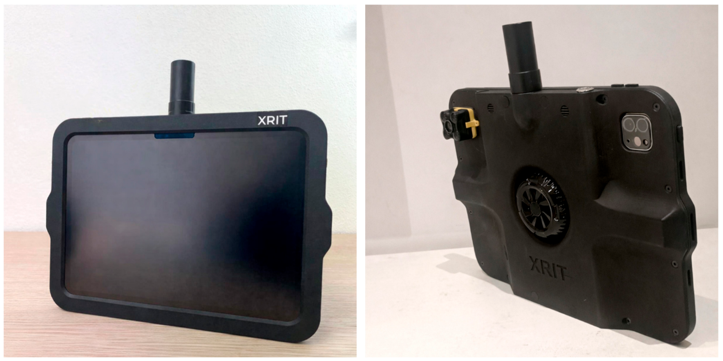
The digital survey described in this study was conducted through the experimental implementation of an integrated Scan-to-HBIM workflow based on multi-sensor mobile acquisition, automatic interpretation and parametric generation of the information model. The XRS platform was used as the operating environment for implementing the method. The tool is configured as an ‘all-in-one’ device, in which the functions of surveying, 3D scanning, measurement, inspection, works accounting and XR visualization are integrated into a single operating unit, which is easily transportable and can be used directly in the field. The central element of the system is an advanced tablet specially modified through the integration of a proprietary electronic board, designed to extend the device’s sensory capabilities and optimize acquisition in morphologically complex contexts (
Figure 1).
The board incorporates a low-latency Bluetooth tracking module to ensure continuous communication with the extended sensors. It also has a user interface (UI) implemented as an independent firmware layer for managing operational parameters and diagnostics. In addition, it has a thermal management system equipped with passive and active cooling mechanisms to ensure operational stability during prolonged sessions. Hardware interfaces for temporal and spatial synchronization between LiDAR, IMU and RGB cameras complete the architecture. These interfaces are based on common time-stamping protocols and enable frame-by-frame multisensory fusion and stable tracking, even in low light or in the event of a temporary loss of visual features.
The proprietary XRS software implements an integrated pipeline for acquiring, processing and modelling information about the built environment. During surveying, the system processes the raw data stream from the LiDAR sensor in real time by applying spatial filtering, temporal smoothing, dynamic motion compensation and noise reduction. This generates a stable and consistent point cloud. In parallel, the platform fuses data from the LiDAR sensor, the IMU and the key points generated by the SLAM algorithm to produce a continuous and robust estimate of the device’s position in space. This approach enables accurate tracking in both indoor and outdoor environments, ensuring continuity of the solution even in the event of temporary satellite signal loss.
Based on the stabilized point cloud, the system activates supervised machine learning models trained on dedicated datasets which automatically recognize walls, openings, floors, furnishings and building services components. These segmented geometries are then converted into parametric BIM primitives that comply with the BIM Forum’s LOD 200 requirements and are enriched by the assignment of semantic properties such as materials, stratigraphy, thicknesses and finishes. The resulting models can be exported in the main interoperable formats (IFC, DWG and all version of Revit), ensuring full compatibility with BIM and Common Data Environment (CDE) workflows.
The semantic recognition stage is performed by an ML-assisted module embedded in the XRS platform. The module operates on the stabilized point cloud generated during acquisition through LiDAR data processing, IMU–SLAM tracking and sensor-fusion procedures. Its function is to identify point-cloud-derived geometric primitives and assign them to BIM-relevant semantic categories. In this study, the considered classes include walls, floors/slabs, openings, stairs, structural elements and secondary components. The output of the recognition stage consists of semantically labelled geometric primitives, which are subsequently converted into parametric HBIM entities according to the target LOD 200. These entities are then checked and refined within the modelling environment and can be verified in the field through the XR interface. In this workflow, the ML component is therefore not an isolated algorithmic contribution, but one operational stage of a broader continuous Scan-to-HBIM process linking acquisition, interpretation, modelling and validation. It should be noted that the underlying training dataset, model weights and complete implementation-level training parameters are part of the proprietary XRS platform and cannot be disclosed due to industrial confidentiality constraints. Consequently, the reproducibility of this study is intended at the level of the acquisition protocol, workflow structure, semantic classes, validation criteria and performance assessment, rather than at the level of re-training the exact proprietary model. Equivalent supervised point-cloud segmentation or classification models may be integrated into the same workflow, provided that they generate BIM-compatible semantic outputs.
The semantic performance of the module was assessed through manual verification of the automatically generated HBIM entities. For each element, typological classification, geometric consistency with the as-built condition and compliance with the required BIM/IFC information parameters were evaluated. In the Gallisai mill case study, 152 automatically generated elements were verified; 134 were correctly classified and parametrically consistent without manual correction, corresponding to a semantic recognition accuracy of 88.2%. The Manual Correction Ratio was 11.8%, and the Parametric Consistency Index was 89.5%.
Integrating a high-precision GPS module with triaxial inertial measurement units (IMUs) enables the automatic georeferencing of scans and consistent alignment between multiple surveys. In the absence of a satellite signal, as is the case indoors or in covered courtyards, alignment is ensured via SLAM connection points and geometric matching algorithms, which preserve spatial continuity between adjacent environments.
Another key feature of the system is the implementation of occlusive extended reality, which enables BIM models to be visualized and interacted with directly within a real-world context while maintaining a high level of perceptual realism and correct spatial positioning of virtual objects, even in complex scenarios. Data synchronization takes place in real time via a cloud-based CDE, supporting multi-user collaboration and revision tracking.
The operational workflow adopted in the study is organized into four main phases: acquisition, recognition, modelling and management. During acquisition, spatial and visual data are collected in the field; during recognition, the acquired data are processed to identify and classify BIM-relevant elements; during modelling, the recognized primitives are structured as parametric BIM entities and enriched with technical information; and during management, the resulting data are archived, synchronized and shared within a collaborative environment.
Figure 2 illustrates the general outline of the XRS workflow, showing how data acquired in the field are progressively transformed into a coherent and interoperable information model.
The following subsections formalize this workflow by defining its main phases, replicability conditions, case-study application and validation criteria.
2.1. General Structure of the Proposed Scan-to-HBIM Workflow
The proposed methodology is structured as a continuous Scan-to-HBIM workflow in which data acquisition, spatial alignment, semantic recognition, parametric modelling and validation are conceived as interconnected stages rather than as separate post-processing operations. The workflow is defined independently of the specific case study and is intended to describe a general operational procedure for generating an HBIM model from integrated multisensor survey data. The pipeline is organized into five main phases: multisensor acquisition, spatial stabilization and alignment, semantic recognition, parametric HBIM generation and validation. Each phase produces an intermediate output that becomes the input for the following stage, reducing the need for repeated data conversion and manual reinterpretation between different software environments. The general structure of the workflow is summarized in
Table 1.
The first phase consists of acquiring spatial and visual data through mobile LiDAR scanning, RGB imaging, inertial measurements and, where available, GNSS positioning. The second phase concerns the stabilization and spatial alignment of the acquired data by integrating IMU–SLAM tracking, geometric matching and point-cloud filtering procedures. This phase produces a spatially coherent and noise-reduced point cloud, which constitutes the geometric basis for the subsequent recognition and modelling stages. In the third phase, the stabilized point cloud is processed by an ML-assisted semantic recognition module, complemented by geometric classification rules. This stage assigns point-cloud-derived primitives to BIM-relevant semantic categories, including walls, floors/slabs, openings, stairs, structural elements and secondary components. The output consists of semantically labelled geometric primitives that serve as the input for parametric HBIM generation. In the fourth phase, the labelled primitives are converted into parametric HBIM entities according to the target LOD 200. This stage associates geometric information with semantic attributes and organizes the recognized elements within a BIM-compatible structure. The final phase consists of validating the generated model through metric control, semantic verification and assessment of manual correction effort. The validated output can then be exported in interoperable formats for use in BIM authoring tools and Common Data Environment workflows.
2.2. Experimental Protocol and Conditions for Replicability
The proposed workflow was defined independently of the specific hardware implementation. At protocol level, reproducibility is ensured by explicitly defining the minimum functional components required to implement the workflow: mobile LiDAR acquisition, RGB imaging, inertial tracking, visual localization or SLAM, point-cloud filtering and alignment, semantic recognition of BIM-relevant elements, parametric HBIM object generation and metric/semantic validation procedures. The workflow does not require the same proprietary hardware configuration, but it does require that these functional components be available within the adopted acquisition and modelling environment. In the present implementation, these functions are provided by the XRS platform. The main data inputs are LiDAR point clouds, RGB images, IMU–SLAM trajectory data and GNSS information where available. Intermediate outputs include stabilized point clouds, aligned indoor–outdoor datasets and semantically labelled geometric primitives. Final outputs consist of LOD 200 HBIM entities exportable in BIM-compatible formats, including IFC, DWG and all version of Revit-compatible formats. Some implementation-level components, including the proprietary semantic recognition module, training dataset and model weights, cannot be disclosed due to industrial confidentiality constraints; therefore, reproducibility is intended at the workflow and protocol level using equivalent tools.
The UAV photogrammetric component was based on discrete image acquisition rather than on frames extracted from video sequences. Images were acquired along predefined flight paths with sufficient overlap to support Structure-from-Motion processing and dense point-cloud generation. Although the present study focuses on the integrated Scan-to-HBIM workflow rather than on UAV photogrammetric optimization, the acquisition mode has been clarified to improve reproducibility.
The survey procedure follows a structured path-planning strategy. The operator executes a continuous closed-loop trajectory covering every level of the building, ensuring at least two independent passes for each main room. This redundancy allows for drift compensation in the SLAM estimates and improves the stability of the global registration. Internal and external acquisitions are connected via transition areas (entrances, openings or courtyards), which act as spatial anchors between GNSS-aided localization and SLAM-based localization. No artificial targets or physical control points are required; instead, the registration uses geometric and visual features present in the environment as natural references.
The minimum acquisition requirements adopted in the protocol include complete coverage of accessible areas, sufficient overlap between adjacent rooms or spatial units, at least one loop closure for each floor or acquisition block, and the connection between indoor and outdoor datasets through identifiable transition areas. The modelling phase follows predefined semantic and geometric criteria. Flat or near-planar surfaces with predominantly vertical orientation are interpreted as candidate wall elements, while load-bearing or walkable surfaces with predominantly horizontal orientation are interpreted as candidate floors or slabs. Voids exceeding a predefined dimensional threshold within the modelling environment are identified as potential openings. In the case of leaning walls, deformed slabs or irregular heritage geometries, these automatic classifications are manually verified and locally refined before being accepted in the HBIM model. These criteria support the ML-assisted semantic recognition module and the conversion of labelled primitives into BIM-compatible HBIM entities according to the target LOD 200.
Under these conditions, the reconstruction of the existing state was not only documentary, but also provided the metric and informational basis for assessing damage, identifying intervention priorities and supporting future restoration or consolidation scenarios.
2.3. Case Study (Former Gallisai Mill)
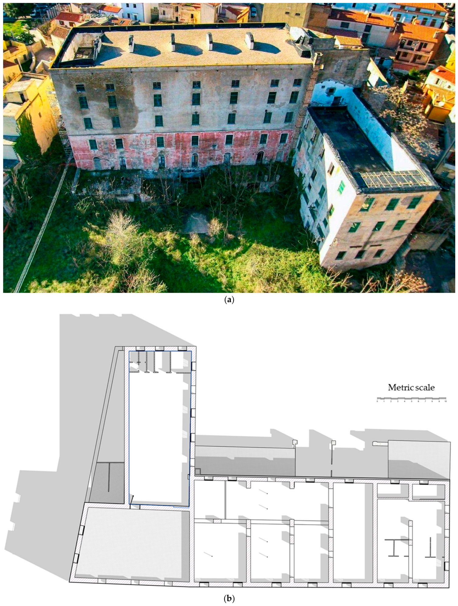
The former Gallisai mill represents one of the most significant industrial heritage sites in Sardinia. Located in Nuoro, the building occupies a strategic position on the edge of the historic center, overlooking the Badde Manna hillside. Its dominant presence makes it a recognizable feature of the urban skyline and a defining landmark for the community. The mill began its industrial operations in 1893, at a time when the town’s economy was still heavily tied to traditional production models. In 1898, the plant began a phase of expansion that transformed the complex into one of the city’s first major industrial enterprises. From the early 20th century onwards, the mill was among the first buildings in the city to be equipped with electricity for wheat processing, becoming a symbol of the region’s economic and industrial modernization.
From an architectural and morphological perspective, the complex covers a total area of over 5000 m
2, with approximately 1400 m
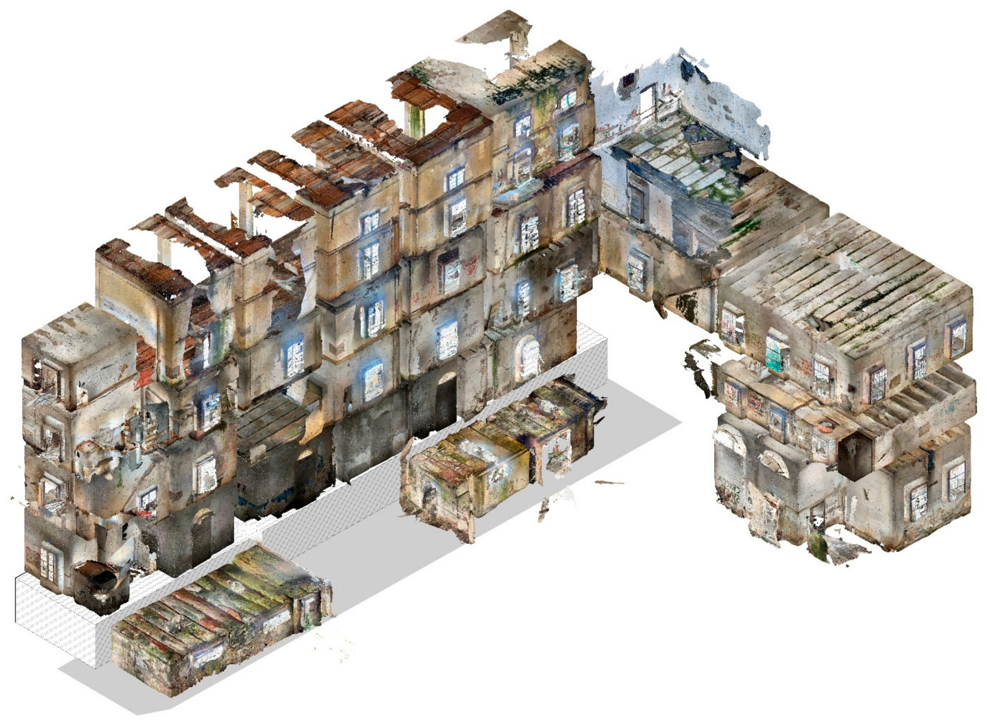
2 of covered floor space and an extensive system of courtyards and ancillary spaces serving the production activities. The main building comprises a basement and five storeys above ground, with a total height of nearly 20 m and a linear length of over 50 m. Analysis of the building reveals a marked stratification of construction, the result of numerous extensions and refurbishments carried out between the 19th and 20th centuries, which introduced floors and structures made of timber, concrete, brick and steel, often combined without a unified design (
Figure 3).
Production gradually ceased in the 1960s, coming to a definitive halt in 1965. From that point onwards, the complex began a slow process of deterioration, exacerbated by a lack of maintenance and repeated damaging events. A first fire, which occurred in 1991, severely compromised a section of the building, damaging structures, wooden floors and part of the plant. A second fire, which occurred in 2022, caused further devastation, destroying historic machinery and exacerbating the existing structural damage. In response to these critical issues, the Region of Sardinia acquired the property and initiated targeted safety and consolidation works, though without undertaking a comprehensive refurbishment. In recent decades, the complex has been the subject of several reuse proposals, confirming its relevance as an industrial heritage asset; however, these aspects are not central to the present methodological validation.
These characteristics make the former Gallisai mill a suitable and demanding case study for testing advanced Scan-to-HBIM workflows. The coexistence of large volumes, overlapping construction phases, irregular geometries, indoor–outdoor transitions, degraded surfaces, partial collapses and accessibility constraints represents a challenging scenario for multisensor acquisition, spatial alignment, semantic recognition and parametric HBIM generation. In this study, the case study is therefore used as the experimental validation context for the workflow defined in
Section 2.1 and
Section 2.2, rather than as a basis for defining the methodology itself.
2.4. Validation and Benchmarking Protocol
The workflow defined in
Section 2.1 and
Section 2.2 was validated on the former Gallisai mill case study through metric, semantic and operational indicators. The validation protocol was designed to assess geometric reliability, semantic consistency, manual correction effort and processing-time reduction with respect to a traditional Scan-to-HBIM pipeline. In order to objectively assess the operational impact of the proposed integrated workflow, a controlled comparison was conducted between a traditional Scan-to-HBIM pipeline (baseline workflow) and the integrated workflow based on the XRS platform. The comparative analysis was set up according to an end-to-end criterion, considering the time interval between the start of the survey campaign and the production of a validated HBIM model ready for interoperable export. The comparison was carried out on the same case study (the former Gallisai mill), keeping the level of detail (target LOD), the operators and the delivery objectives constant. The unit of measurement adopted is time expressed in actual working hours.
2.4.1. Definition of the Baseline Workflow
The traditional pipeline was structured according to a sequence representative of current practices in the AECO sector, comprising:
- −
Mobile LiDAR acquisition for indoor environments and UAV photogrammetry for outdoor environments;
- −
Photogrammetric processing (Structure-from-Motion and dense reconstruction);
- −
Registration and alignment of point clouds using ICP algorithms;
- −
Data cleaning and preliminary segmentation;
- −
Manual HBIM modelling in a BIM authoring environment;
- −
Final verification and export of the model.
The data processing, registration and preparation stages were carried out off-site, in dedicated software environments separate from the acquisition phase.
The integrated workflow follows the general pipeline defined in
Section 2.1 and illustrated in
Figure 2. In the benchmarking procedure, this workflow was compared with the baseline Scan-to-HBIM pipeline under the same case-study conditions, target LOD and delivery objectives.
2.4.2. Measurement Criteria
The validation protocol was defined to assess the workflow from metric, semantic and operational perspectives. Metric reliability was evaluated by comparing control measurements collected in situ with the corresponding measurements extracted from the generated point cloud and HBIM model. The main indicator adopted for this purpose was the Mean Absolute Error (MAE), which is commonly used to quantify the average magnitude of deviations between measured and reference values. Point-cloud density was also considered to verify whether the acquired data provided sufficient geometric support for HBIM modelling and the recognition of architectural and structural elements. Semantic performance was assessed by manually verifying the HBIM entities generated through the semantic recognition stage. For each element, the validation considered typological correctness, geometric consistency with the as-built condition and compliance with the required BIM/IFC information parameters. The semantic recognition accuracy was calculated as the ratio between correctly classified entities and the total number of automatically generated entities. In addition, the Manual Correction Ratio (MCR) was used to quantify the proportion of generated elements requiring manual correction, while the Parametric Consistency Index (PCI) measured the proportion of correctly recognized elements that also satisfied the predefined parametric and information requirements.
Operational performance was evaluated through an end-to-end time comparison between the baseline workflow and the integrated workflow. The comparison considered the total time required from the beginning of the survey campaign to the production of a validated HBIM model ready for interoperable export. Time reduction was calculated as the percentage decrease in total processing time relative to the baseline workflow. These criteria allow the workflow to be evaluated not only in terms of processing speed, but also in terms of metric reliability, semantic consistency and manual correction effort.
2.4.3. Time Assessment
In the integrated workflow, alignment, preliminary filtering and initial semantic structuring are performed automatically during the acquisition phase using SLAM and sensor fusion algorithms. Consequently, some of the activities traditionally classified as post-processing are absorbed in real time on-site. Off-site activities are limited to residual quality control operations, any local fine-tuning and completion of the HBIM modelling (
Table 2).
To ensure a methodologically consistent comparison, the total time has been broken down into:
- −
Field time (acquisition and integrated operations);
- −
Off-site time (residual processing, modelling and verification).
The percentage reduction was calculated according to Equation (1):
where
is the total end-to-end time of the traditional workflow and
is the total end-to-end time of the integrated workflow.
In the present comparison,
and
; therefore, the reduction is:
3. Results
The survey of the former Gallisai mill produced a high-density point cloud, generated through the integration of external photogrammetric acquisitions and internal LiDAR surveys using mobile scanning. The combination of the two sources made it possible to obtain a continuous, georeferenced three-dimensional model, overcoming the difficulties associated with the building’s geometric complexity and areas of difficult access.
The exterior of the building, characterized by very large surfaces, complex facades and signs of surface deterioration, was surveyed using a UAV flight with close-range trajectories and a grid at varying angles of incidence. This approach enabled the acquisition of high-resolution images and an accurate reconstruction of the vertical geometries. The interior, on the other hand, was surveyed using a mobile LiDAR device, capable of operating effectively even in critical conditions such as low light, the presence of debris, collapsed flooring and uneven surfaces. This approach enabled the acquisition of high-resolution images and an accurate reconstruction of the vertical geometries. The interior, on the other hand, was surveyed using the XRS platform, based on a modified Apple iPad equipped with integrated mobile LiDAR, RGB imaging, inertial tracking and proprietary hardware components for sensor synchronization. This configuration allowed data acquisition in critical conditions such as low light, the presence of debris, collapsed flooring and uneven surfaces.
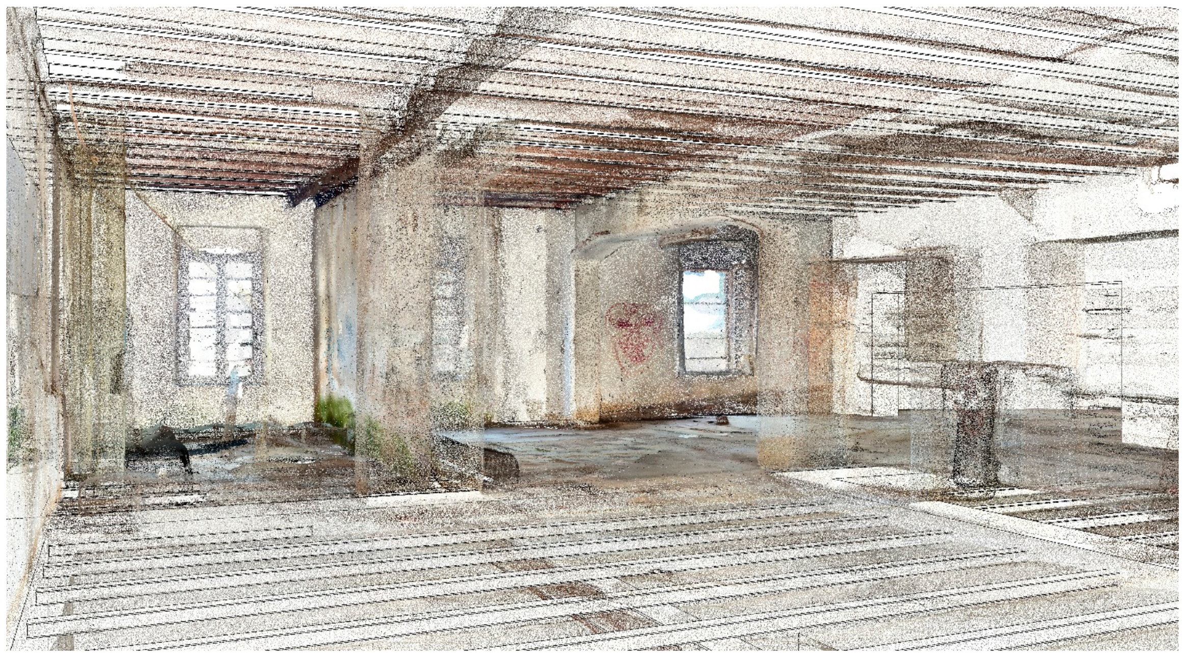
Figure 4 illustrates the outcome of the integrated acquisition process, highlighting the density and robustness of the alignment between the different datasets. As reported in the density analysis, the interior point cloud reached values of approximately 395–444 pts/m
2, while the UAV-derived exterior surfaces reached approximately 571–600 pts/m
2. In particular, the interior point cloud exhibits a high-density texture that allows for the clear distinction of geometric discontinuities in the wall facings, floor deformations, charred surfaces and areas of collapse caused by the fires, confirming the mobile LiDAR system’s ability to acquire information even under conditions of poor spatial visibility.
The external point cloud, derived from UAV photogrammetry, shows highly stable alignment with the BIM model, as confirmed by the metric validation results reported below. The measured deviations at the control points remained below 2 cm, with an overall MAE of 1.68 cm (
Figure 5).
Preliminary alignment between the external and internal datasets was achieved through automatic georeferencing, based on the combination of the device’s inertial and visual sensors. This process exploits the synergy between:
- −
IMU, which provides high-frequency estimates of the scanning unit’s accelerations and angular velocities;
- −
SLAM, which uses visual and geometric features of the environment to correct IMU drift, localizing the device in real time and simultaneously generating a three-dimensional map.
The IMU–SLAM integration allows us to obtain an initial approximation of the rigid transformation required to bring the indoor point cloud into the georeferenced coordinate system of the outdoor point cloud. This initial transformation can be represented as (2):
where X is a point in the local indoor point-cloud coordinate system,
is the transformed point in the target georeferenced coordinate system,
is the initial rotation matrix, and
is the initial translation vector. Both,
and
are estimated from the integration of SLAM tracking, IMU measurements and virtual control points generated within the XR environment. This initial solution was subsequently refined using ICP algorithms and bundle adjustment optimization, producing the final transformation (3):
where R and t are estimated via non-linear minimisation of the residual error [
51].
The quality of the integration is confirmed by the global RMS error values, which are less than (4):
and by the local standard deviation (4):
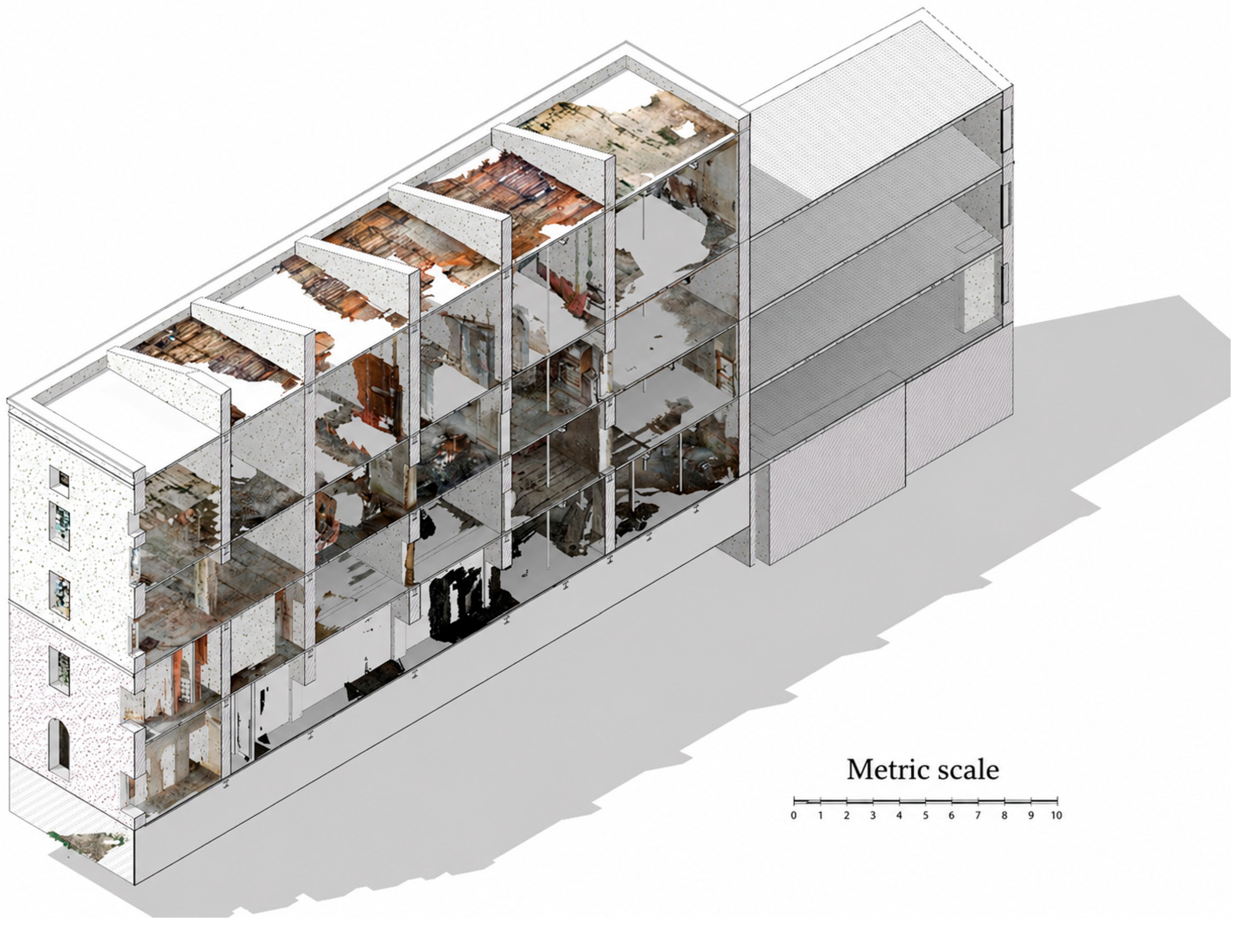
The global metric consistency of the survey is confirmed by the topological continuity observable in the indoor–outdoor overlap: the different scan blocks show a transition without significant offsets, suggesting a correct estimation of the rigid transformations (roto translations) during the registration phases. The absence of local misalignments and the congruence of intersections between surfaces from different acquisitions are an indicator of the numerical stability of the optimization process and the quality of the overall bundle adjustment (
Figure 6).
The comparative analysis between the measurements taken on-site and the data extracted from the point cloud confirmed the high metric reliability of the digital survey. To this end,
control points were selected and distributed across the various levels of the building, chosen from wall corners, beam–column intersections and characteristic floor levels. For each point
, the error was defined as the difference between the measurement derived from the model and that taken on site (6):
where:
: distance or elevation of point measured on the point cloud;
: distance or elevation of the point measured in situ using topographic or distance-measuring instruments.
Subsequently, to assess the overall quality of the dataset, the Mean Absolute Error (MAE) was calculated, defined as (7):
Table 3 shows the set of points used for validation. The absolute errors are consistently less than 2 cm, whilst the overall MAE value is 1.68 cm, fully compatible with the tolerances required for structural consolidation and restoration of built heritage.
The integrated workflow reduced the total end-to-end time from 94 h to 67 h, corresponding to a reduction of 28.7%, approximately 29%, compared with the baseline workflow. The main time savings were observed in the registration, alignment, cleaning and segmentation stages, where several operations were absorbed into the acquisition phase through SLAM-based tracking, sensor fusion and preliminary semantic structuring.
Beyond time reduction, the integrated workflow improved the continuity of the indoor–outdoor model, particularly in transition spaces such as staircases, corridors and partially collapsed areas. In the baseline workflow, these areas required more manual reconstruction due to local misalignments between independent datasets. The integrated approach also shifted the role of the operator from retrospective reconstruction of the point cloud to verification and refinement of the generated HBIM entities.
To complete the evaluation of the dataset, point cloud density was also analyzed, defined as the ratio between the number of points present in a given portion of the model and its projected area (8):
where:
: point cloud density (points per square metre, pt/m2);
: number of points in the point cloud within the sample area under consideration;
: projected area (in m2) of the analysed building section.
The aim of the metric validation is to verify whether the integrated workflow meets the geometric requirements necessary for preliminary structural analyses and documentation of the built heritage. The mean absolute error (MAE) value of 1.68 cm falls within the tolerances generally required for HBIM modelling of existing buildings. The distribution of errors shows no systematic bias, indicating that the registration procedure does not introduce directional distortions. The deviations remain stable across different stories of the building and under varying acquisition conditions, including degraded areas and those with poor spatial readability. This demonstrates that near-real-time modelling does not compromise the metric reliability of the survey. Although the survey was designed with an operational target density of 350 pts/m2, a posteriori estimation of the actual density was necessary to verify the homogeneity of the sampling, the absence of under-sampled areas, and the compliance of the acquired data with the requirements of the target LOD 200 HBIM model.
This verification is particularly relevant in a complex context such as that of the former Gallisai mill, where degraded surfaces, irregular geometries and variable lighting conditions can affect the success of the acquisition. Furthermore, the external component, acquired via UAV photogrammetry and reconstructed using an SfM pipeline, showed a higher and more variable point density than the indoor LiDAR dataset, as reported in
Table 4. This variability is consistent with the characteristics of image-based reconstruction, where point density depends on image acquisition geometry, surface texture, camera-to-object distance and the effectiveness of feature matching during SfM processing. The metric validation results, with deviations below 2 cm and an overall MAE of 1.68 cm, indicate that the integration of SLAM, IMU and ICP-based refinement ensured adequate metric stability for the target LOD 200 HBIM model.
The main benefit of the integrated workflow is not limited to acquisition speed. The continuous connection between acquisition, semantic interpretation and modelling reduces the need to reinterpret the data during post-processing. In traditional workflows, modelling represents an interpretative process in which the operator reconstructs architectural elements based on geometric evidence. In the proposed method, modelling becomes a validation activity primarily, as the semantic structure of the model is generated during the survey.
This change explains both the reduction in time and the greater topological consistency observed in the final BIM model (
Table 4).
The results show an average density of between 350 and 450 points/m2 in indoor areas and close to 600 points/m2 on outdoor surfaces captured by UAV. This combination of metric accuracy (MAE < 2 cm) and point density ensures a level of detail suitable for identifying architectural and structural elements, as well as detecting major geometric anomalies, providing a solid foundation for subsequent BIM and for analysis and design activities.
Assessment of Semantic Performance
In addition to the metric validation of the point cloud and the generated HBIM model, an analysis of the semantic performance of the integrated workflow was carried out, with the aim of assessing the reliability of the automatic recognition of building elements and the consistency of their parametric structuring within the BIM environment.
The evaluation was carried out through a systematic manual verification of all HBIM entities automatically generated in the case study of the former Gallisai mill. For each element, the following aspects were assessed: correctness of typological classification, geometric consistency with the acquired point cloud and compliance with the required information parameters, including IFC category, main dimensions and spatial relationships. Geometric consistency was assessed with reference to the metric validation tolerance adopted in this study. It should be noted that degraded areas, material decay and damage patterns were not automatically detected or modelled as independent semantic classes. Their presence was represented indirectly through the acquired point cloud and, where relevant, through manual verification and local refinement of the generated HBIM entities. The automatic recognition process focused on the main architectural and structural components, such as walls, floors/slabs, openings and secondary structural elements, while the interpretation of degradation phenomena remained an expert-assisted operation outside the scope of the automatic segmentation module.
Overall, the system automatically generated 152 HBIM entities, including walls, floors/slabs, openings and secondary structural components. These 152 entities represent the set of automatically detected elements evaluated in this study, rather than an exhaustive inventory of all possible building components present in the asset. Of these generated entities, 134 were correctly classified and parametrically consistent without the need for manual intervention, corresponding to a recognition accuracy of 88.2% within the automatically generated dataset. Since an independent ground-truth inventory of all existing elements was not available, this indicator should be interpreted as a correctness measure for generated entities rather than as a complete recall measure for all elements that could theoretically be recognized. The remaining elements required limited corrective action, mainly attributable to:
- −
Typological misclassifications in the presence of irregular or severely degraded geometries;
- −
Inaccuracies in the delineation of surfaces in areas characterized by occlusions or material discontinuities;
- −
Cases of overlap between adjacent elements with similar geometric characteristics.
According to the validation criteria defined in
Section 2.4.2, the Manual Correction Ratio (MCR) was 11.8%. This value indicates that only a limited proportion of the automatically generated HBIM entities required manual correction, confirming a reduction in human intervention compared with traditional Scan-to-HBIM workflows, where parametric modelling is generally performed mainly through manual interpretation of the point cloud.
The Parametric Consistency Index (PCI) was 89.5%. Specifically, of the 134 semantically correct entities, 120 fully met the predefined parametric and IFC-related information requirements. This result confirms that most of the correctly recognized elements were not only typologically classified, but also sufficiently consistent for integration into the target LOD 200 HBIM model.
The semantic validation shows that the integrated workflow provides a reliable basis for the assisted structuring of HBIM entities in the tested heritage case study. However, residual manual corrections remain necessary in the presence of irregular geometries, material discontinuities, degradation phenomena and elements that are difficult to classify automatically.
4. Discussion
In recent years, Scan-to-BIM procedures have played a pivotal role in the digitization of existing built heritage. The literature identifies several significant trajectories for consolidating Scan-to-BIM workflows, including process automation, geometric classification, semantic recognition, and advanced parametric modelling. This development stems from the intrinsic complexity of digitizing the built environment and the fragmentation of procedural workflows, which remain organized into separate segments that rely on different software and manual operations. Recent developments in computer vision techniques and deep learning methods have substantially improved semantic segmentation procedures, facilitating the transition from descriptive models to structured representations. Despite these advances, currently documented pipelines remain sensitive to operational factors that significantly affect the quality of the final result. The most frequent challenges include the heterogeneity of input data, variability in survey conditions, noise or discontinuities in datasets, and difficulty correctly identifying complex, non-standard, or degraded elements. Furthermore, the limited availability of public archives and annotated datasets hinders the training of machine learning models, negatively affecting their ability to generalize. This results in significant reliance on manual intervention for model validation or correction, leading to increased processing times and reduced overall reliability. In the context of the case study, these issues are particularly evident when considering how damaged elements, charred surfaces, partial collapses, and structural deformations complicate the acquisition phase and prevent the direct application of standardized procedures. Integrating multi-sensor acquisition, spatial fusion and information modelling achieves a higher level of metric consistency, progressively reducing reliance on subsequent registrations and minimizing information loss during transitions between operational phases.
The specific conditions of the former Gallisai mill directly influenced the implementation and validation of the workflow. Deterioration, material discontinuities, partial collapses and superimposed construction phases increased the complexity of both data acquisition and semantic interpretation. These conditions required careful trajectory planning, repeated passes in critical areas and particular attention to indoor–outdoor transition zones in order to preserve spatial continuity between acquisition blocks. From the modelling perspective, irregular geometries and degraded elements often prevented a direct correspondence between point-cloud evidence and standard parametric primitives, making manual verification and local refinement necessary for some automatically generated HBIM entities. Rather than representing only a limitation, the complexity of the case study provided a demanding validation context, allowing the workflow to be tested under conditions in which conventional Scan-to-HBIM procedures are more likely to suffer from misalignment, semantic ambiguity and manual reinterpretation.
The semantic validation results indicate that the integrated workflow can support reliable semantic structuring of HBIM entities under complex heritage conditions. This is particularly relevant in the former Gallisai mill, where deformations, construction stratifications and degradation phenomena increased the difficulty of automatic recognition and required manual verification of ambiguous or irregular elements.
Based on these elements, the research opens up broader reflections on the potential of the Scan-to-HBIM approach. The growing maturity of automatic recognition techniques indicates more continuous workflows and reduced human intervention in preliminary stages, while parametric modelling and extended reality suggest cognitive environments capable of integrating surveying, interpretation and control directly in the field.
The results obtained demonstrate the potential for using integrated platforms to create a continuous workflow in which acquisition, interpretation, and information modelling are closely linked and developed iteratively within a single operational pipeline. This is an improvement on traditional approaches, which rely heavily on sequential procedures and the combination of disparate software, increasing uncertainty and the risk of misalignment between data and model. Experimentation shows that native integration of sensor fusion algorithms, SLAM techniques and automatic recognition processes substantially reduces manual registration operations, a key source of cumulative error in processing point clouds. Another contribution is the integration of parametric modelling and intelligent element recognition, enabling the point cloud to be transformed into BIM entities with semantic attributes from the outset. The model is no longer the final outcome of separate operations, but is constructed progressively as the survey progresses, adapting to the building’s actual conditions. This is particularly relevant in complex environments characterized by deterioration, material stratification, and superimposed construction phases, as demonstrated in the Mulino Gallisai case study. Overall, the results suggest a methodological shift in information modelling, geared towards greater data continuity, fewer manual operations, and more immediate correlation between data capture and digital representation.
4.1. Digitalisation and XR in the Case Study Workflow
The application of XR within Scan-to-BIM processes now represents a significant advance over traditional methods of surveying, modelling and validation, as it introduces a cognitive dimension that complements and integrates the technical one. XR enables a direct relationship to be established between the built environment and the digital representation, allowing the information model to be visualized and interpreted within the real-world context. This can support a more immediate understanding of spatial relationships, geometric discrepancies and material conditions, particularly in historical or degraded buildings where conventional desktop-based validation may be less intuitive.
In the present study, XR was used as an in-field verification and visualization layer within the integrated Scan-to-HBIM workflow. Its role was not to implement a complete management or monitoring environment, but to support the comparison between the generated HBIM entities and the physical condition of the former Gallisai mill during validation and refinement. This was particularly relevant in areas characterized by degradation, irregular geometries, partial collapses and indoor–outdoor transition zones, where the correspondence between point-cloud data and parametric HBIM elements required direct spatial inspection. The main benefit of XR in the case study was therefore operational and cognitive. By enabling the operator to visualize the model in relation to the actual building context, XR supported the identification of local discrepancies, the verification of element positioning and the refinement of automatically generated entities. In this sense, XR contributed to reducing the interpretative gap between survey data and HBIM representation, especially in parts of the building where geometric discontinuities, material degradation or spatial complexity made the validation process more demanding.
The application of XR in this study remained limited to field-based visualization and verification. The workflow did not implement a complete XR-based management system, nor did it integrate IoT or structural monitoring data for dynamic model updating. For this reason, XR should be interpreted here as a support tool for assisted validation and cognitive inspection of the HBIM model, while its broader use for collaborative management, monitoring and Digital Twin-oriented applications remains a future development.
4.2. Limitations
Although the integration of digital surveying, parametric modelling and immersive technologies significantly enhances the operational continuity of the Scan-to-HBIM process, certain limitations inherent to the nature of the data, the acquisition conditions and the state of the art of automatic interpretation algorithms still raise technical and scientific questions that require further investigation. A primary concern relates to the quality of point clouds, the reliability of which depends largely on sensor behavior and acquisition scenarios. In the presence of irregular surfaces, severely degraded materials, variations in brightness or physical obstacles, the density and homogeneity of the points may be non-uniform, leading to uncertainties in the geometric reconstruction and, consequently, in the automatic interpretation phase. These issues are compounded by the presence of interference and noise, which can negatively affect the segmentation phase, generating errors of both under-segmentation and over-segmentation. These phenomena particularly affect elements characterized by irregular geometries, complex material conditions or structural deformation, phenomena that elude classifications based exclusively on models trained on relatively homogeneous datasets. The most recent methods based on machine learning and deep learning do indeed demonstrate significant performance in controlled contexts, but remain less effective in recognizing secondary components, non-planar surfaces, morphological irregularities or architectural stratifications resulting from historical processes. Furthermore, despite the use of advanced automatic recognition techniques, the quality of the datasets available for training machine learning and deep learning models remains limited. The scarcity of open-access collections, the presence of private datasets and the limited typological variability of the cases studied restrict the algorithms’ generalization ability and affect their performance in complex environments or in the presence of conditions not anticipated during training. The lack of shared standards, both methodologically and semantically, contributes to the models’ performance remaining inconsistent and heavily dependent on contextual conditions. From an interoperability perspective, conversion processes to open formats, whilst theoretically compliant with IFC standards, require further verification, as complex geometries, non-canonical configurations and structural deformations are difficult to map to standardized parametric primitives. This situation can lead to differences in geometric rendering or in the accuracy of semantic information during the migration of models between different platforms. This results in a margin of uncertainty that can affect the quality of the transferred information, particularly when moving between proprietary BIM software or between different digital coordination environments. A final consideration concerns the current lack of established metrics to unambiguously assess the degree of accuracy, automation and efficiency of integrated pipelines. The absence of shared validation protocols, the heterogeneity of software tools and the variability of survey conditions make it difficult to carry out systematic and reproducible comparisons between different approaches, limiting the definition of benchmarks and the comparability of performance. This gives rise to a growing need to develop uniform assessment tools capable of measuring not only geometric fidelity, but also semantic consistency, the level of automation, topological robustness and the operational quality of the information model throughout the entire digital cycle.
4.3. Future Developments
The ongoing integration of digital surveying, parametric modelling and immersive technologies is opening up new avenues for development, affecting both the technical evolution of Scan-to-HBIM workflows and the expansion of their applications. Firstly, the refinement of machine learning and deep learning algorithms will enhance the automation of the recognition and classification phase, reducing the need for manual intervention and broadening the range of identifiable elements, particularly in cases where structural complexity or material deterioration present challenges that cannot be resolved using deterministic methods. The development of models trained on more extensive and diverse datasets, capable of representing the many specific features of both historic and contemporary buildings, represents a priority area of research to improve the generalization ability of algorithms and ensure more robust semantic segmentation. A second area of development concerns the construction of advanced interoperability systems based on open standards that can be effectively implemented throughout the entire building information lifecycle. The definition of shared methodological protocols, the standardization of conversion processes, and the development of IFC libraries specific to heritage buildings can form the basis for consistent and replicable workflows. In this regard, particular attention must be paid to the management of complex and non-canonical geometries, as well as to the integration of parametric models with high-information-content representations capable of capturing material, structural and diagnostic conditions. From an application perspective, one element of innovation concerns the transition from static digital models to dynamic DT, in which surveying, monitoring and updating converge into a unified and continuously evolving system. The adoption of distributed sensors and the integration of data from the IoT, structural monitoring systems and extended reality platforms will enable the generation of HBIM models updated in real time, useful both for assessing the condition of the building and for planning maintenance work. Finally, the convergence of information modelling, immersive systems and collaborative environments may facilitate the transition towards collective working methods, in which surveying, design, control and management will be carried out in environments shared by multiple users and equipped with advanced analysis functions. This prospect opens up particularly significant scenarios for the governance of the built environment, where knowledge is based on interdisciplinary collaboration and the sharing of information across different technical and scientific disciplines. In this context, the development of multi-user immersive platforms represents one of the most promising directions for the evolution of Scan-to-HBIM processes and for the definition of digital ecosystems capable of supporting complex decisions, transformative processes and advanced building management practices.
Although several aspects of the workflow were validated through the former Gallisai mill case study, some limitations and potential weaknesses of the method must be explicitly acknowledged. First, the validation is based on a single heritage building characterized by degradation, irregular geometries and construction stratifications; therefore, the results cannot be directly generalized to modern buildings, conventional structures or dense urban environments. Second, despite the acquisition protocol was structured to improve repeatability, operator-related factors such as scanning trajectory, acquisition speed, coverage strategy and experience in path planning may influence the quality of the acquired data and the resulting HBIM model. Third, the method may be less effective in environments with severe occlusions, very narrow spaces, highly reflective or transparent surfaces, repetitive geometries, poor visual features, or unstable lighting conditions, where SLAM tracking, point-cloud completeness and semantic recognition can be affected. Fourth, the automatic recognition of HBIM elements may require more manual correction in the presence of highly irregular components, severe material degradation, partial collapses, non-standard construction details or elements not represented in the training domain of the semantic recognition module. Finally, the validation was conducted with a target LOD 200; therefore, the reported processing-time reduction and Manual Correction Ratio should not be extrapolated directly to LOD 300/400 workflows, which require additional expert interpretation, material characterization and conservation-specific information enrichment.
5. Conclusions
This study presents and experimentally evaluates a continuous Scan-to-HBIM workflow for generating HBIM models from integrated multisensor survey data. The proposed pipeline comprises five main stages: multisensor acquisition; spatial stabilization and alignment; semantic recognition; parametric HBIM generation; and XR-based verification and export. The workflow’s primary methodological contribution is the integration of these stages into a single operational process, which reduces the discontinuities that typically arise when acquisition, point-cloud processing, semantic interpretation, and BIMs are carried out in distinct environments. The workflow was validated using the former Gallisai mill as a case study. This complex industrial heritage building is characterized by degradation, irregular geometries, construction stratification, partial collapses and indoor–outdoor discontinuities. This demanding case study allowed the workflow to be tested under conditions in which conventional Scan-to-HBIM procedures are particularly susceptible to misalignment, semantic ambiguity and manual reinterpretation. The application demonstrated that the proposed approach can generate a geometrically coherent and semantically structured LOD 200 HBIM model by integrating mobile LiDAR, UAV photogrammetry, IMU–SLAM tracking and ML-assisted semantic recognition.
Metric validation confirmed the reliability of the generated dataset, with a mean absolute error of 1.68 cm. The semantic assessment showed recognition accuracy of 88.2%, manual correction ratio of 11.8%, and parametric consistency index of 89.5%. These results confirm that, while manual verification is still required in the presence of degraded, irregular or non-standard elements, the workflow can support the assisted generation of HBIM entities. Therefore, the results demonstrate metric consistency and the potential of the integrated workflow to reduce the interpretative gap between the point cloud and the information model. Compared with the traditional Scan-to-HBIM baseline workflow, in which acquisition, point-cloud processing, semantic interpretation and BIMs are carried out as sequential stages, the integrated workflow reduced the total processing time from 94 to 67 h, a reduction of approximately 29%. This improvement was mainly due to a reduction in post-processing operations, registration procedures, and manual reinterpretation between software environments. More broadly, the workflow shifts the operator’s role from manually reconstructing the model to verifying and refining automatically generated HBIM entities.
However, the results must be interpreted within the limits of the present validation. The workflow was tested on a single heritage case study with a target LOD 200, so its performance cannot be generalized directly to modern buildings, dense urban environments or higher LOD 300/400 applications. Additionally, the ML-assisted semantic recognition module is partly proprietary, and the Digital Twin-oriented potential of the workflow has not been validated through IoT or structural monitoring data. Future research will focus on multi-case validation, operator sensitivity analysis, benchmarking at higher levels of detail (LODs) and integration with monitoring systems to support dynamic HBIM and digital twin-oriented workflows. Despite these limitations, the study demonstrates the feasibility of a continuous Scan-to-HBIM pipeline that can improve data continuity, metric reliability, semantic structuring, and operational efficiency in complex heritage contexts. This study supports the transition from sequential post-processing modelling to assisted, integrated, validation-oriented HBIM generation.