Article

Green Infrastructure as an Urban Landscape Strategy for the Revaluation of the Ite Wetlands in Tacna

1
Faculty of Architecture and Urban Planning, Federico Villarreal National University UNFV, San Miguel, Lima 15088, Peru
2
Post Graduate University School-EUPG UNFV, Lima 15001, Peru
3
Faculty of Architecture and Urban Planning, Ricardo Palma University, Santiago de Surco, Lima 15039, Peru
4
Ricardo Palma University, Santiago de Surco, Lima 15039, Peru
5
Research Laboratory for Formative Investigation and Architectural Innovation (LABIFIARQ)–URP, Lima 15039, Peru
6
La Molina Agrarian University, La Molina, Lima 15039, Peru
*
Author to whom correspondence should be addressed.
Buildings 2025, 15(3), 355; https://doi.org/10.3390/buildings15030355
Submission received: 23 August 2024 / Revised: 30 November 2024 / Accepted: 16 December 2024 / Published: 24 January 2025
(This article belongs to the Section Architectural Design, Urban Science, and Real Estate)

Abstract

This study is focused on proposing a green infrastructure design that revalues the Ite Wetlands in Tacna. Currently, the Ite Wetlands are experiencing significant degradation mainly due to water pollution in the wetland and other associated environmental and social impacts. This situation is exacerbated by nearby mining activity, which includes the discharge of mining tailings that negatively affect water quality and the surrounding natural environment. An exhaustive diagnosis was conducted, considering multiple urban and environmental aspects, such as topography, road networks, climatic conditions, and biological diversity. The green infrastructure and revaluation project for the Ite Wetlands in Tacna has generated significant results, highlighted by the careful design of green corridors. The implementation of interpretive trails, rest areas, birdwatching viewpoints, and botanical gardens has transformed the wetlands into a multifunctional environment that promotes environmental conservation and biodiversity. This initiative has not only revitalized the area but strengthened the cultural and social identity of the region. The proposal provides a sustainable development model that can serve as inspiration for other natural areas facing degradation.

1. Introduction

Wetlands originate in areas that are constantly flooded, fostering the growth of flora and fauna adapted to these conditions. The importance of wetlands lies in their significant environmental value due to their biodiversity and the services they provide to the environment and society. One of the greatest threats to wetlands is the accelerated degradation and disappearance of wetlands compared with other ecosystems. In the 20th century, there was a global decrease of 64–71% in wetlands, which continues to this day [1]. The main causes of wetland degradation and disappearance are population growth, pollution, and eutrophication [2].
Peru has 76 protected natural areas, including protection forests, hunting reserves, national parks, and others [3] (Figure 1). There are 14 wetlands recognized as Ramsar sites, designated for ecosystems categorized as Wetlands of International Importance, across the country, ten of which are located in nine of the protected natural areas [4]. Protected natural areas in Peru are crucial for the conservation of biodiversity and the maintenance of essential ecosystem services, such as climate regulation and the water cycle [5,6]. They host a rich variety of flora and fauna, many of which are endemic and endangered, and are fundamental for scientific research and the development of medicines [7]. Additionally, these areas play a vital role in the preservation of indigenous cultures, providing resources and sacred spaces. Their conservation also promotes ecotourism, generating income and fostering environmental education among locals and visitors [8,9].
The wetlands of the Bay of Ite are located in the district of Ite, province of Jorge Basadre, Tacna region. The Ite wetland is included in the National Wetlands Conservation Strategy but lacks legal protection. Regional Ordinance 020-2007 CR/GOB.REG.TACNA declares the conservation of the flora and fauna of the Ite wetlands to be of regional public interest, but it does not allocate a budget to improve this aspect [11,12]. Its degradation is mainly due to pollution from mining tailings since 1960, which has had significant consequences. The exploitation of the Toquepala and Cuajone mines located in Tacna generated tailings that were deposited in the Locumba River and Ite Bay, affecting 300 km of Ite Bay since 1960. In 1989, Supreme Decree No. 020-89, approved by the President of the Council of Ministers, established that tailings should no longer be discharged into the seashore because of the pollution they caused [13]. The high presence of metals such as copper, molybdenum, lead, mercury, zinc, iron, silica, cyanide, and silver caused pollution and the disappearance of species such as shrimp. The accumulated residues still represent a threat to the livestock of shepherds, goats and sheep that graze on the grass in the area [14].
Studies conducted in 1991 in the area revealed the presence of high concentrations of arsenic, cadmium, lead, copper, chromium, and cyanide with values exceeding the limits established in the Water Law of Peru for shellfish and bivalve fishing areas of 10 mg/L for arsenic, cadmium, lead, copper, and cyanide and 2 mg/L for cadmium [15]. The high content of heavy metals in the bay caused the contamination of shellfish and fish (pelagic and benthic) and their disappearance due to high toxicity or bioaccumulation. Additionally, the increase in turbidity caused the disappearance of some species. Fifty-five percent of the tailings had solid content. The main elements and substances contained in the tailings were copper, lead, mercury, zinc, iron, silica, cyanide, fats, etc. Approximately 300 km2 of Ite Bay were contaminated.
In 1972, following the contrasting observations made in 1960 by the Head of the Fisheries and Hunting Research Division of the Ministry of Agriculture, which mentioned the existence in the area of a dense population of crustaceans and a usual algal flora and fauna in this habitat, the Ite Agrarian Cooperative Reserve presented a Memorandum to the Ministry of Fisheries denouncing the damage to the ichthyological resources of the area caused by the discharge of tailings into the Locumba River, evidenced by the disappearance of species such as shrimp, mullet, sea urchins, and clams. After the metal contamination, the establishment of hydrobiological resource processing industries was postponed, and the execution of the Punta Meca Grande Fishing Complex and Puerto Grau (Caleta Morro) Project was canceled, affecting the regional economy [16].
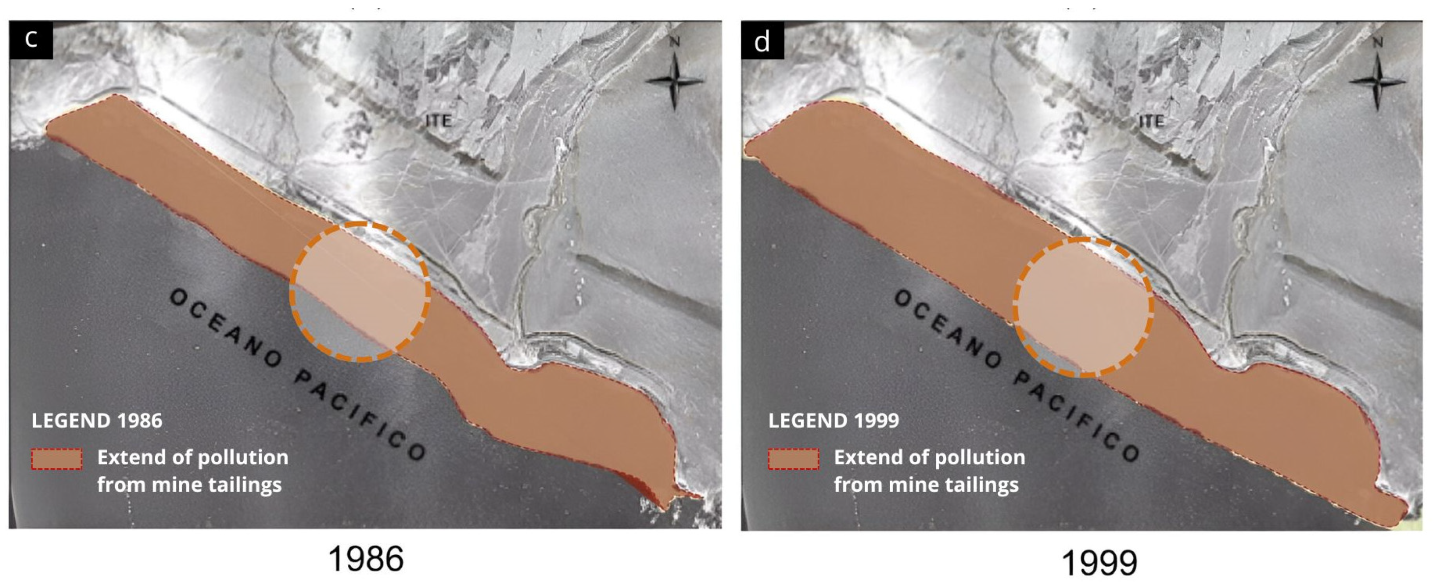
The degradation of the natural ecosystem of the wetland in Ite Bay began in 1955 (Figure 2) because of the deposition of mining tailings, which introduced heavy metals and other toxic pollutants into the environment. These wastes, resulting from mining activities, progressively accumulated, affecting the quality of water and soil, as well as local biodiversity. In 1956, the development work for the Toquepala mine in Tacna, Peru, began. Subsequently, the Toquepala and Cuajone mines started operations in 1960 and 1976. Southern’s main metallic products were copper, molybdenum, and silver. As a consequence of these operations, the river waters became a means to transport the tailings to the fields and then discharge them into the Pacific Ocean through the Locumba River and Ite Bay, generating heavy metal contamination. Between 1979 and 1986, the extent of the degradation significantly increased, as shown in Figure 2b, spreading along the bay and exacerbating the negative impacts on the wetland ecosystem. Between 1960 and 1976, activities in Ite Bay caused severe wetland contamination due to the deposition of mining tailings. This process significantly deteriorated the marine coastline, altering it to encompass more than 1600 hectares, with a width of 1.5 km and a length of 12 km. In 1996, mining tailings deposits were suspended by Supreme Decree No. 02089, but this action could not reverse the consequences of the contamination, which led to the growth of the wetland.
Figure 2a shows the extent of pollution caused by mining relatives in 1955, with an initial presence of pollution in the surrounding areas, although limited compared to later years. Figure 2b shows that in 1979, pollution from mine tailings has increased considerably, affecting broader areas. This increase reflects the growth of mining activities and the accumulation of waste without adequate control. Figure 2c shows that by 1986, pollution has reached a greater extent, covering an even larger area and affecting various nearby ecosystems. The accumulation of tailings and the lack of mitigation measures continue to exacerbate environmental problems. Figure 2d shows that in 1999, contamination by mining kin has reached critical levels, affecting large areas of land and water, with serious consequences for local biodiversity and environmental quality. Each year reflects a progression in the expansion of pollution due to mining activities and lack of control over relatives.
On 3 April 2016, a wildfire burned 90 hectares in the southern area of the Ite Wetland, Tacna. The fire negatively impacted the flora, including species such as totora, rushes, and reeds, as well as the fauna, affecting herons, ducks, and coots. Additionally, it harmed two species that depend directly on this vegetation for their survival, the rushbird and the many-colored rush tyrant [17].
As a result of industrial activities in the mining sector, critical areas for aquatic and migratory birds, many of which are considered rare, have been compromised. Birds are now exposed to significant threats due to the alteration of the ecological balance caused by this destruction. The intervention site has highly degraded areas, making it important to implement green infrastructure. This infrastructure will include a linear park composed of public spaces, viewpoints, and recreational areas that will allow for the revaluation of the Ite wetlands [18]. The main objective of the green infrastructure is to create an integrated scheme that seeks to establish spatial, landscape, and ecological continuity, connecting the environmental elements of the territory with significant environmental, cultural, agricultural, and landscape value, as well as areas at risk [19,20].
There are precedents where the implementation of green infrastructure positively impacted the ecosystem. For example, in Lupanshui, China, the main function of the ecological structure called Minghu Wetland Park is to provide various ecosystem services, assist with stormwater management, water purification, and the recovery of native habitats. Recovery was achieved by integrating existing streams, wetlands, and lowlands into a stormwater management and ecological purification system linked by the river and public spaces composed of walking paths, bike lanes, rest areas, viewpoints, and bridges. The impact of this project was economic, by increasing land value; social, by increasing urban vitality; and environmental, through stormwater management, cleaning of contaminated water, and restoration of native habitats for biodiversity [21]. Another approach to wetland revaluation is demonstrated by the Tibabuyes Wetland Ecological Park in Colombia, which was designed along the 6 km of the wetland to connect, recover, and preserve the ecosystem, addressing previous threats and problems. The project includes public spaces for education, contemplation, recreation, and leisure, compensating for the lack of an urban-landscape approach focused on the integrity of the wetland [22]. In Mexico, the Laguna del Carpintero Wetland project was developed around five aspects, road conversion, the system of public spaces and facilities, the reconfiguration of blocks, the integration of collective housing and modest heritage, and urban parameters, which together are aimed at the revaluation of the wetland. According to a study, after carrying out the densification and urban revitalization of the area, land value could increase up to 1.8 times the current price. Urban redevelopment has thus become an opportunity to foster community interaction and prosperous development in Tampico and its metropolitan area [23] (Figure 3).
  • The green infrastructure project in the Ite Wetlands, Tacna, will apply various strategies inspired by successful solutions at an international level.
  • Ecological corridors will be established that connect the wetlands with other nearby green areas, promoting the migration of species and the conservation of biodiversity.
  • Artificial wetlands will be implemented that will serve both to restore the ecosystem and to offer recreational and educational spaces to the public.
  • Permeable pavements and aquatic vegetation will be used to manage stormwater, reducing the risk of flooding and improving water quality.
  • The project contributes to the Sustainable Development Goals (SDGs), in particular SDG 6 (clean water and sanitation) and SDG 15 (life on terrestrial ecosystems), promoting the restoration of wetlands and the conservation of biodiversity.
Therefore, this study aims to propose a design strategy for a green infrastructure that promotes the revaluation of the Ite Wetland, located in the district of Tacna.

2. Materials and Methods

2.1. Methodology

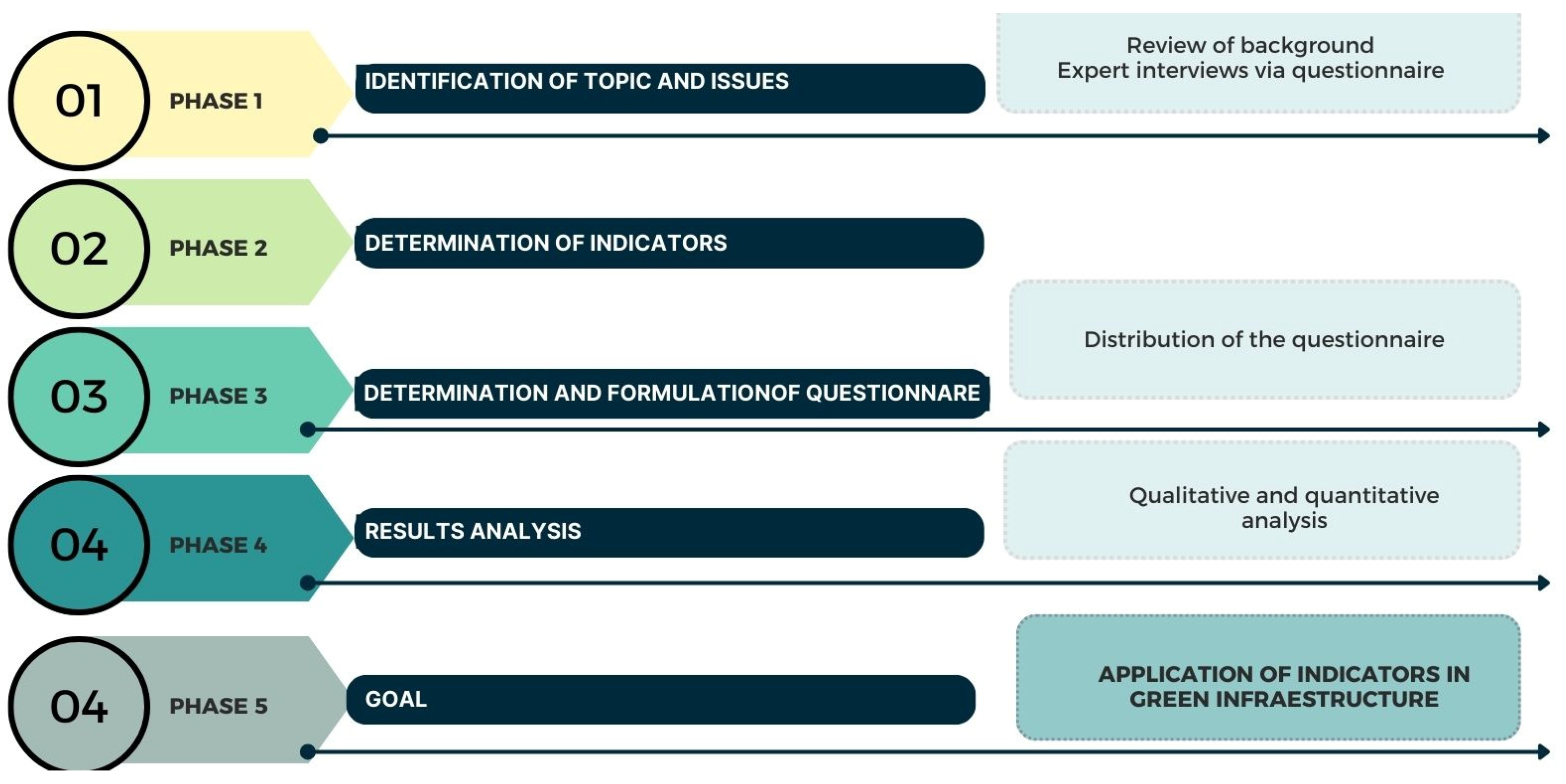
This study focuses on the analysis of green infrastructure strategies aimed at the conservation and revaluation of the Ite wetlands in Tacna based on an exhaustive bibliographic review. The environmental and urban challenges facing this area are highlighted, especially in terms of ecosystem degradation and loss of biodiversity. Because of the importance of wetlands as spaces for climate mitigation, species conservation, and generation of ecosystem services, it is urgent to implement sustainable solutions. To address these problems, a green infrastructure design that integrates environmental conservation indicators, obtained through surveys and interviews with experts in ecology and urban planning, is proposed (Figure 4).

2.2. Identification of Topic and Issues

2.2.1. Background Check

Initially, a review of the relevant literature on environmental problems and the ecological importance of wetlands in urban and periurban areas was carried out. In particular, the situation of the Ite wetlands in Tacna was examined, analyzing the conservation and sustainability challenges facing this area. From this review, eight key indicators were established for the design of green infrastructure, based on theories of urban ecology and environmental sustainability, with the objective of promoting the restoration and valorization of wetlands as critical spaces for biodiversity and mitigation of climate impacts.

2.2.2. Interviews with Experts

Interviews were conducted with 15 experts in green infrastructure and environmental conservation using a structured questionnaire developed after an exhaustive analysis of the literature on wetlands and ecological sustainability. The experts included ecologists, urban planners, and architects with at least 10 years of experience in wetland conservation and restoration projects. In addition, they had specializations related to environmental sustainability, which made it possible to address ecological and social aspects related to green infrastructure. A structured questionnaire (Table 1 and Table 2) was used to collect feedback on the 8 proposed indicators, evaluating their impact on the restoration and revaluation of the Ite wetlands.
The first part focused on defining the profile of the urban and natural environment in the context of wetlands, exploring how an urban landscape strategy can be integrated into a design to maximize its ecological and social impact. The second part focused on the revaluation of these spaces, gathering expert opinions on the benefits of green infrastructure on the quality of life of local communities and on the conservation of the ecosystem (Table 3).

2.2.3. Questionnaire

To formally administer the questionnaire, 150 forms were completed to evaluate the correct application of the indicators.

2.3. Determination of Indicators

To attain an efficient green infrastructure that promotes the ecological restoration and resilience of the Ite wetlands, the implementation of key indicators that guide the design and sustainable management of the space is necessary (Table 4). These indicators will allow us to evaluate and enhance the environmental, social, and economic impact of the interventions, ensuring that they effectively contribute to the conservation of the ecosystem and the well-being of local communities.

2.4. Development and Formulation of the Questionnaire

2.4.1. Questionnaire Distribution

The analysis focused on the Ite wetland, evaluating its current state and conservation needs through two types of instruments: 1. an ecological evaluation sheet and 2. a survey of experts in environmental restoration, complemented by photographic tours. The data obtained were analyzed using a Likert scale. For the photographic documentation, three essential criteria were established: 1. display the environment through panoramic views that encompass the wetland ecosystem, 2. capture natural occurrences and the interactions of local species within their habitat, and 3. take ground-level shots to reflect the perspective of the flora and fauna of the wetland.
The survey was structured around eight proposed indicators linked to a spatial analysis and educational resources. It utilized the Likert scale to gauge varying levels of opinion, employing the following scale for assessment: (1) totally disagree; (2) disagree; (3) neutral; (4) agree; (5) strongly agree.

2.4.2. Questionnaire Design

Participants evaluated key indicators on green infrastructure and its impact on the Ite wetlands. 120 responses were obtained (Table 5).
  • Coverage of green spaces: Opinions on whether the number of parks, gardens, and natural areas is sufficient for local needs.
  • Biodiversity: Perception of the conservation status of species and habitats and their sufficiency to satisfy the needs of the community.
  • Urban density: Assessment of whether the level of construction and population is adequate and does not negatively affect the quality of life.
  • Access to essential services: Opinion on the availability and accessibility of services such as transportation, health, and education.
  • Effectiveness of green infrastructure: Opinions on whether green spaces help in water and air quality management.
  • Urban design and quality of life: Opinion on the impact of urban design on the quality of life of the community.
  • Adaptation to climate change: Perception of the area’s capacity to adapt to extreme climate events.
  • Environmental education: Assessment of whether environmental education in the area is adequate to inform residents about local problems.

2.5. Analysis of Questionnaire Results

Qualitative and Quantitative Analysis

The evaluation carried out in the Ite wetland provided information on the current state and application of green infrastructure in the area, specifically in relation to ecological restoration and the integration of natural spaces. Environmental health indicators, such as water quality, biodiversity, and ecosystem connectivity, were not applied systematically or with clearly established parameters. In most cases, restoration and conservation efforts were insufficient or moderate, limiting the potential for environmental improvement in the area (Figure 5).

3. Results

3.1. Study Area

The Ite wetlands, also known as the Ite Lagoons, cover an area of 1680 hectares and are located in the Ite district, within the Jorge Basadre province of the Tacna department, Peru. They are situated 90 km northwest of the city of Tacna (17°53′17″ S, 70°59′17″ W; sea level). These wetlands have been recognized as an Important Bird Area and are the second largest in South America, standing out as one of the main tourist destinations in the Tacna region (Figure 6). The project is located in the Ite wetland because of its high ecological importance, which harbors unique biodiversity, although it faces threats such as pollution from mining activities and environmental degradation. The placement of the green infrastructure, in this case, a linear park, was strategic, as the wetland’s vegetation allows it to integrate with green infrastructure, promoting community connection with nature and fostering environmental awareness. Additionally, wetlands provide an ideal environment for recreational and educational activities focused on conservation and ecotourism. However, this is not currently happening in the surroundings of the Ite wetlands because of their degradation [27].

3.2. Climatological Analysis

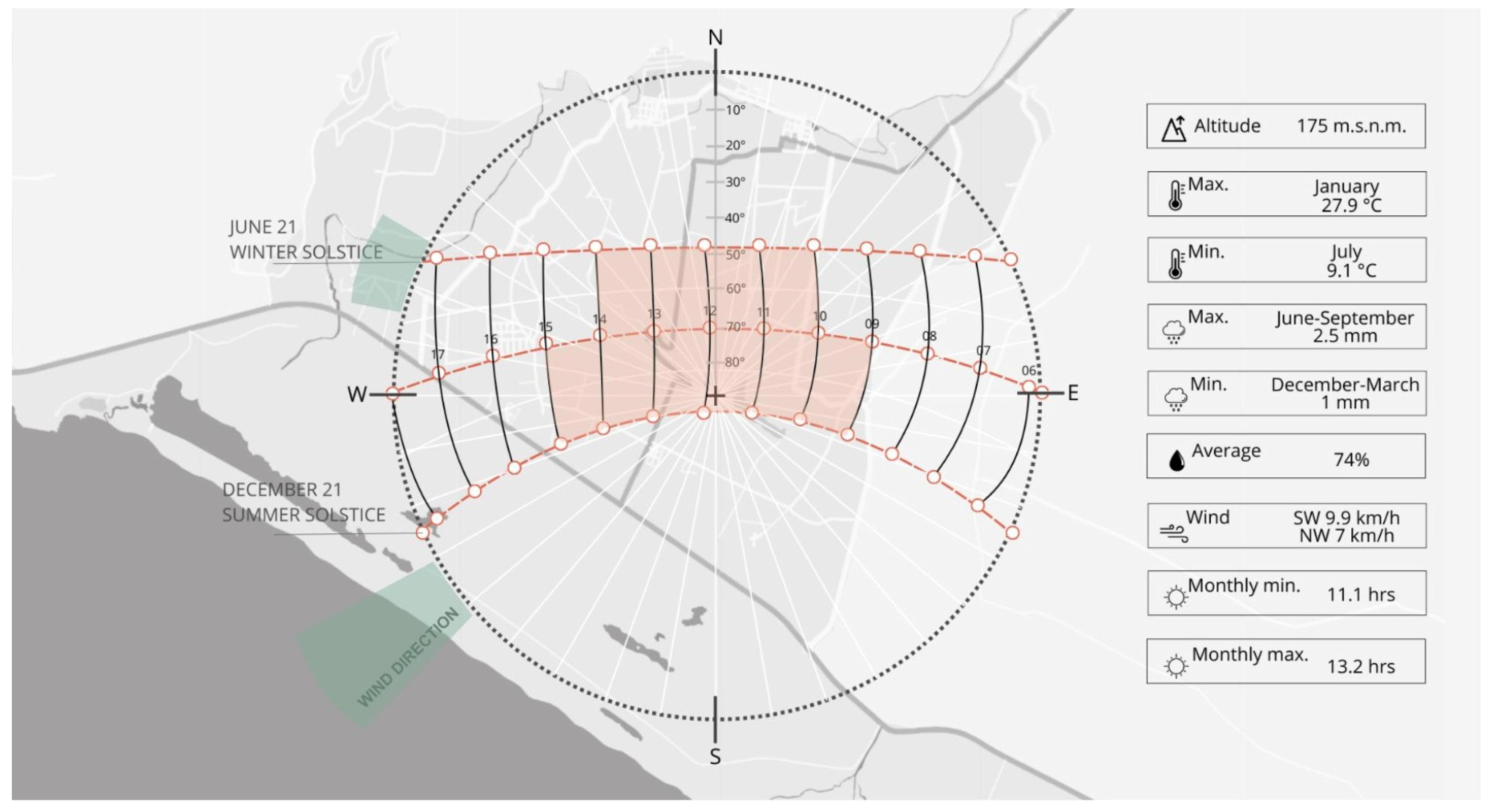
The following graph allows us to understand in a clearer and more detailed way the climatological information of Ite. In it, we can observe various aspects of the climate, such as temperature, wind direction, precipitation levels and hours of sunshine, which helps us to have a complete view of the climatic conditions in this region (Figure 7).
Tacna has a temperate and desert climate along the coast, characterized by warm, dry summers and mild winters. The average annual maximum temperature ranges from 27.9 °C from January to March, while temperatures drop to 9.1 °C from June to August. This climatic variation leads to a diversity of habitats, which host a wide variety of flora and fauna adapted to their environment.
Humidity peaks at around 78% from May to September and decreases to around 71% from January to April, remaining below 80%. Maintaining humidity above 60% is essential for biodiversity, water quality, climate regulation, and flood prevention in wetlands. Humidity supports unique habitats, filters pollutants, provides shelter for migratory birds, and contributes to the sustainability of vital resources for people.
Precipitation is scarce during the summer months, averaging 1 mm, with higher levels reaching 2.5 mm from June to September. Consequently, the intensity of precipitation in Tacna is low even in winter, when temperatures are cooler. Like other coastal wetlands, Ite experiences the most pronounced reduction in water levels during the summer months because of low precipitation.
Predominant winds come from the southwest, with average speeds exceeding 9.9 km/h from March to September, commonly known as a light breeze. The winds promote air circulation, facilitate seed and pollen dispersal, contribute to evaporation, and regulate temperature. These processes are crucial for maintaining the health and balance of the wetland ecosystem.
Tacna experiences higher solar radiation in February and November, ranging from 5.5 kWh/m2 to 7.5 kWh/m2 in the western part of the region, particularly in the province of Jorge Basadre, where the Ite wetlands are located. Essentially, Tacna’s climatic diversity, characterized by its various microclimates and altitudinal changes, plays a fundamental role in fostering and protecting a wide range of flora and fauna.

3.3. Environmental Analysis

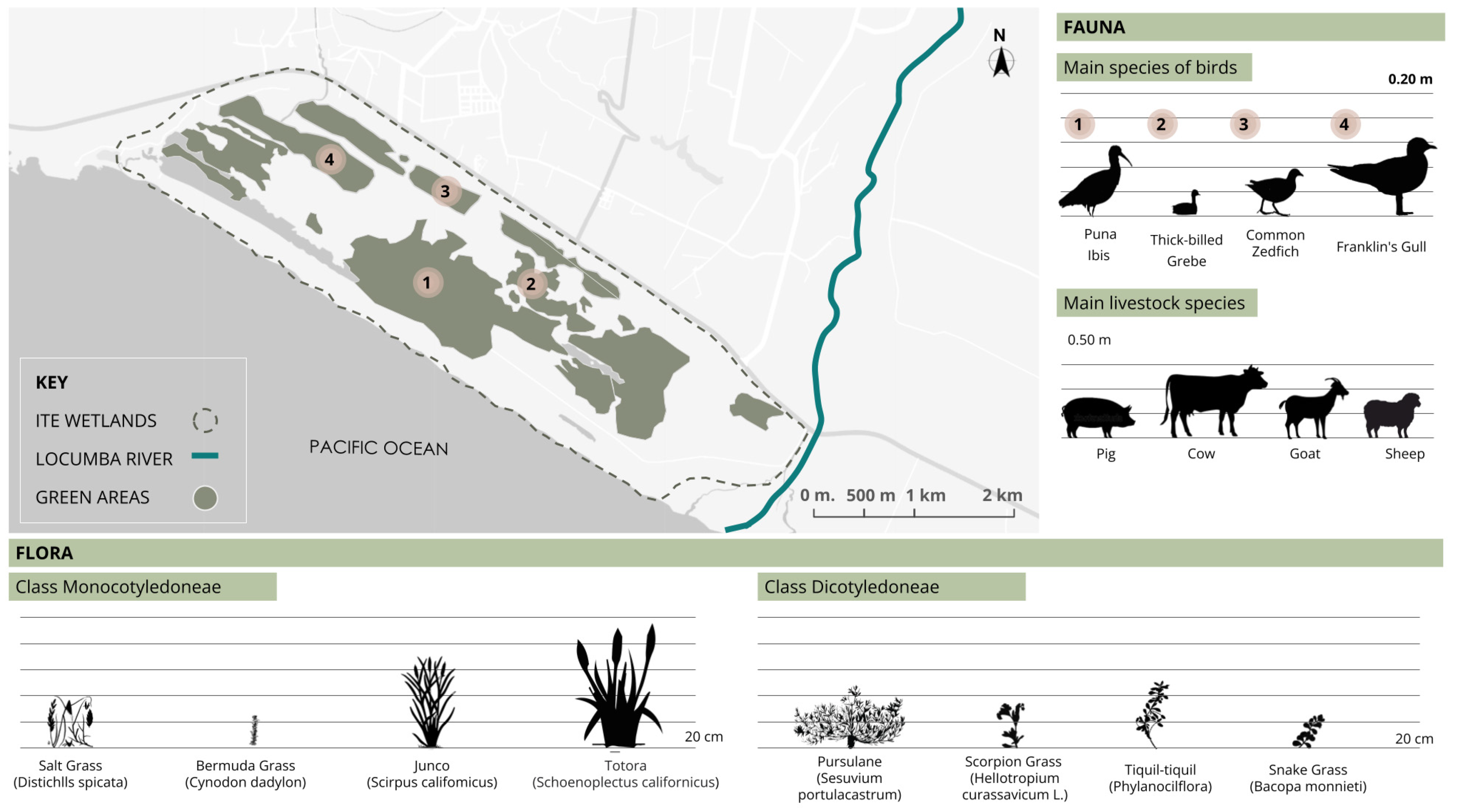
The wetland is composed of floating green areas and water; more than half of its total surface is covered with green spaces (Figure 8). Its flora includes various types of marsh vegetation such as herbaceous plants, including bulrushes, reeds, grasses, purslane, and water parsley. Because of these conditions, these areas serve as important permanent or temporary habitats for a variety of birds. In 2009, a study identified 139 new bird species, including the gray gull, the little grebe, the Andean avocet, the booby, and the great egret. Many of these species are considered endangered, highlighting the need for solutions to preserve these ecosystems and their species.

3.4. Accessibility

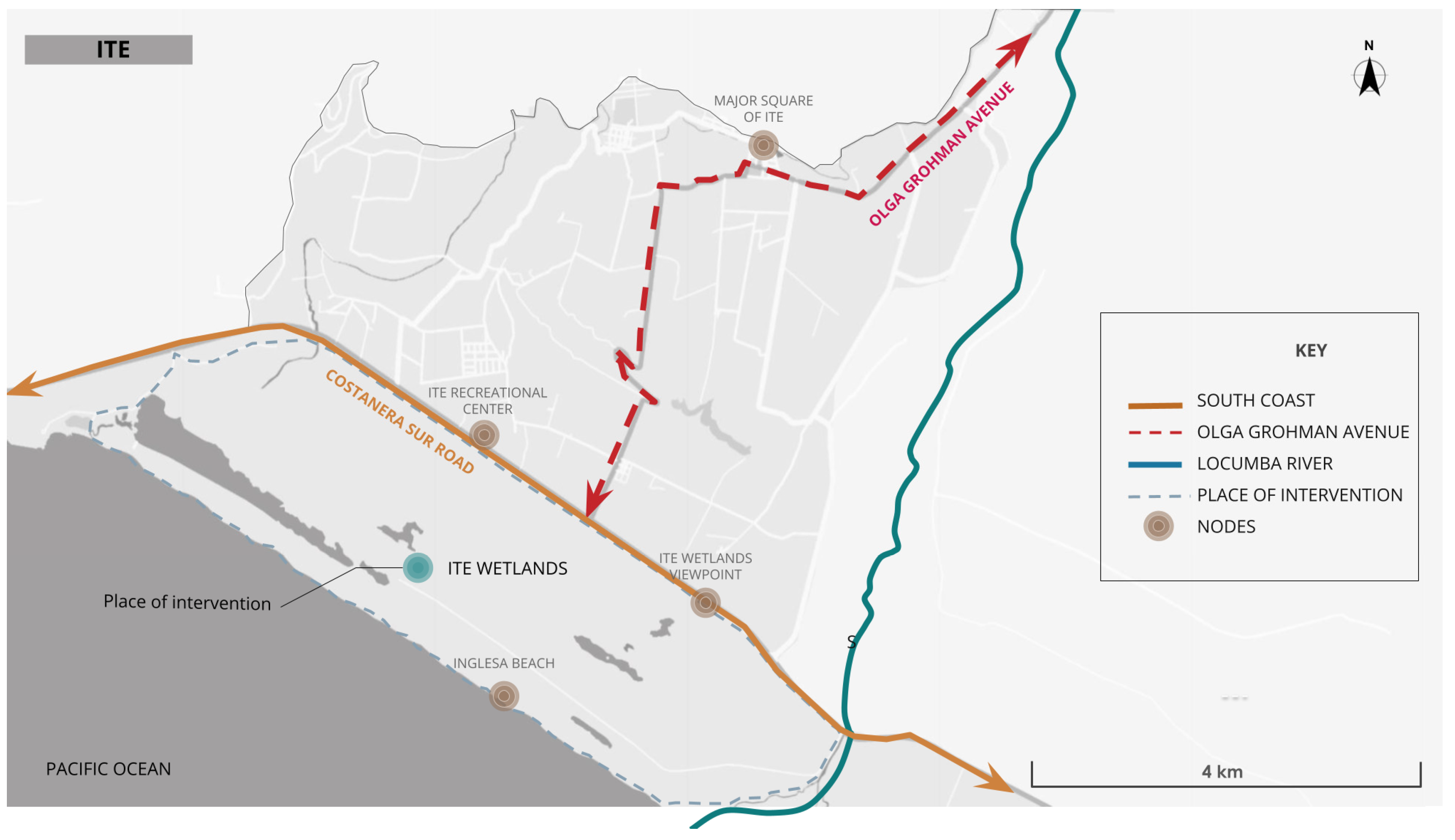
The Ite wetlands are located between kilometers 60 and 72 of the Carretera Costanera Sur, 90 km from the city of Tacna, and 0.5 km from Avenida Olga Grohmann de Basadre, which runs through the entire district of Ite and connects it by road to the city of Tacna (Figure 9).

3.5. Zoning

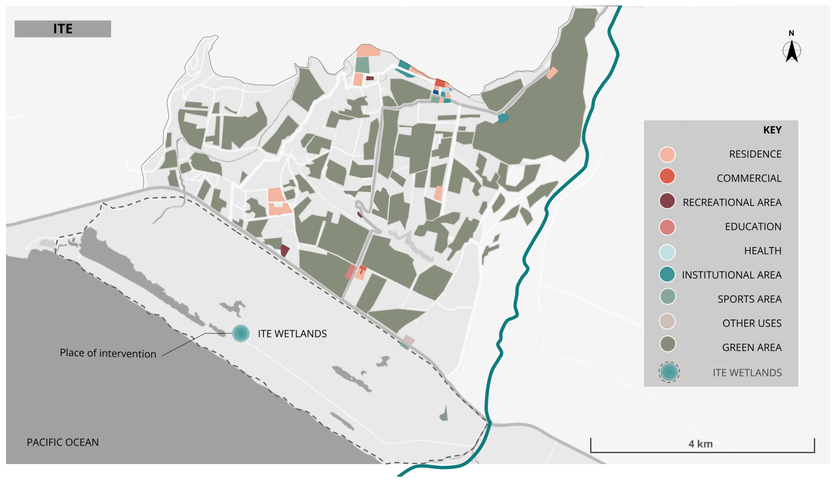
The research area shows few uses, mainly because of the predominance of green spaces dedicated to agriculture. Other uses include residential areas, which are complementary to agricultural areas, and scattered businesses near orchards throughout the district. The recreational areas are located near the wetland, which is common for tourism (Figure 10).

3.6. Vulnerability

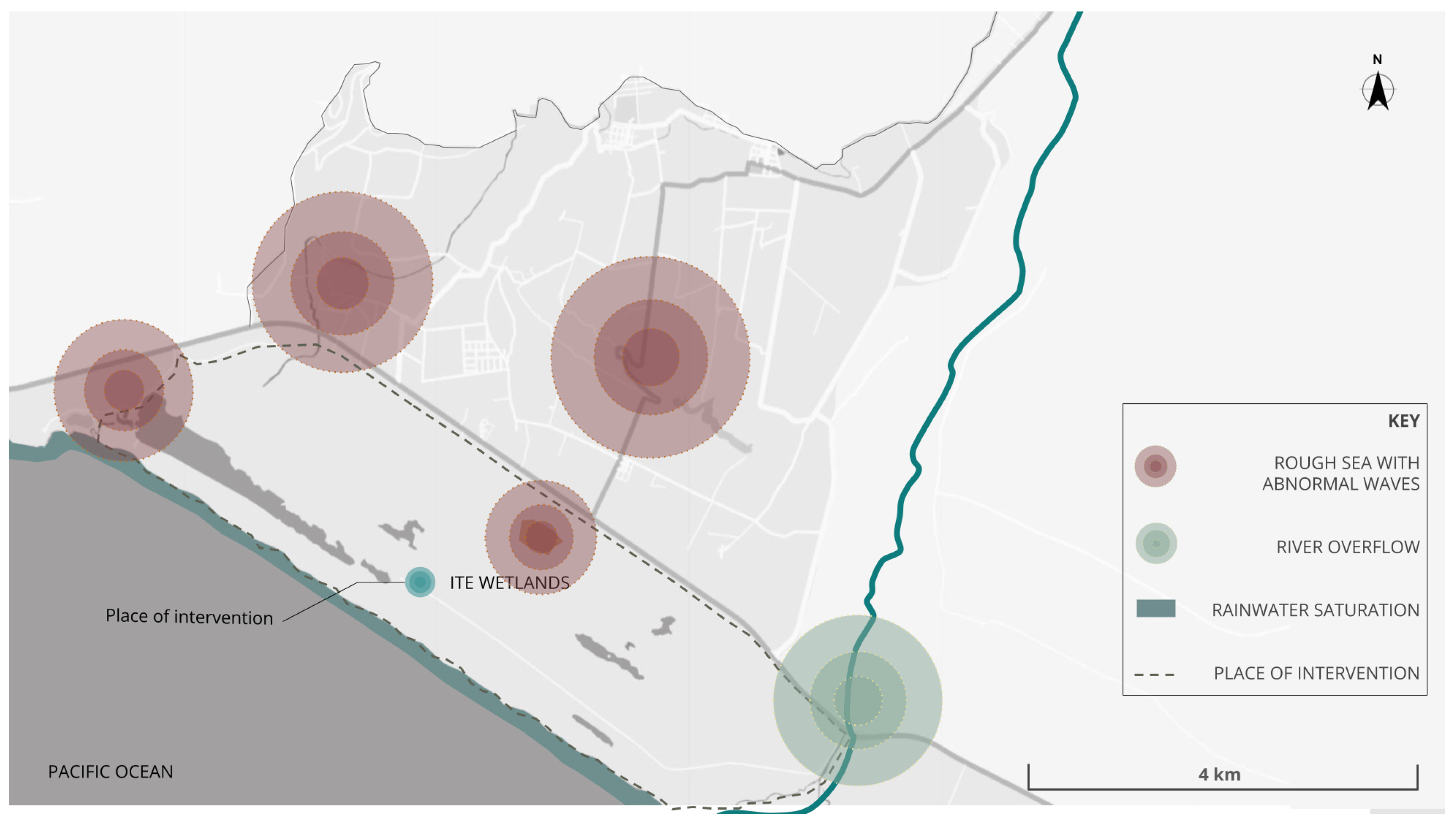
As shown in Figure 11, the Ite wetlands, in addition to climatic changes, are exposed to other factors specific to their location. On the border with the sea, they are exposed to the impact of the sea due to anomalous waves that cause erosion and flooding in the low coastal area and occur constantly.

3.7. Master Plan

The proposal suggests a linear park consisting of three main plazas connected along the wetland. It includes the implementation of seven bird observation viewpoints to provide visitors with the opportunity to observe birds in their natural habitat. Additionally, floating islands with purifying plants will be installed to clean the water through their roots by absorbing heavy metals or excessive nutrients from wetland water and improving its quality. Interpretive trails are designed to create an ideal circuit for navigating the wetland, offering visitors detailed information about the area’s ecology and the importance of its conservation. The botanical garden, located on the terraces, features both medicinal and ornamental plants, allowing visitors to learn about local flora and its value. Finally, a biodrainage system has been installed to address potential flooding, thereby protecting both the environment and the park’s visitors (Figure 12).
Implementing green infrastructure can help reduce mine tailings in several ways by integrating sustainable practices and technologies into mineral resource management and waste treatment [28,29,30]. The green infrastructure proposal proposes the following solutions:
  • Land Rehabilitation: Green infrastructure proposes the rehabilitation and revegetation of areas affected by mining.
  • Water Management Systems: Green technologies for water management, such as natural filtration systems and artificial wetlands, will be implemented. These systems can reduce the amount of contaminated water mixing with the tailings by treating the water before it comes into contact with the tailings, thus decreasing contamination.
  • Erosion Control: The use of vegetation and green engineering techniques, such as terrace construction and natural barriers, can minimize erosion of tailings deposits.
  • Use of Sustainable Building Materials: Incorporating recycled and low-environmental-impact building materials can help to reduce the amount of tailings generated.
The linear park project has a total area of 123,450 m2. In addition, the intervention on the wetland, consisting of trails and viewpoints, adds an additional area of approximately 30,150 m2. This green infrastructure has a capacity of 43,145 people (Table 6).

3.8. Analysis and Implementation of Indicators in Architectural Design

The survey results contributed significantly to the design of green infrastructure in the wetland, reflecting a coherent integration of key indicators. The coverage of green spaces and biodiversity were addressed through the implementation of a botanical garden and birdwatching areas, elements that promote the preservation of local flora and fauna, in addition to contributing to adaptation to climate change. Accessibility was improved with interpretive trails and bike paths that facilitate sustainable mobility and strengthen the connection between the community and the ecosystem. Efficiency and quality of life were optimized through the use of biofilters for water purification and solar panels, solutions that minimize environmental impact while providing practical benefits for users. Likewise, the inclusion of an ecomuseum and the implementation of solid waste management systems were aimed to strengthen environmental education, promoting community participation in wetland conservation. These findings reflect how the priorities and needs identified in the survey were integrated into a balanced and sustainable green infrastructure design that addresses both ecological and social requirements (Table 7).

3.9. Design Strategies

Strategies to enhance the Ite wetlands through a linear park include the comprehensive ecological restoration of the habitat by reintroducing native plant species and rehabilitating soils, along with implementing ecological corridors that facilitate connectivity between the wetland and surrounding natural areas [31]. Green infrastructure solutions such as permeable pathways and bike lanes will be integrated to reduce runoff impact, complemented by sustainable drainage systems such as rain gardens and infiltration trenches to improve water quality. The design will include educational and interpretive areas to increase environmental awareness and community engagement [32,33]. Additionally, a continuous monitoring program will be established to assess ecosystem health and adjust management strategies, while recreational use management will ensure that human activities do not compromise the ecological integrity of the wetland [34,35].

3.9.1. Purifying Plants

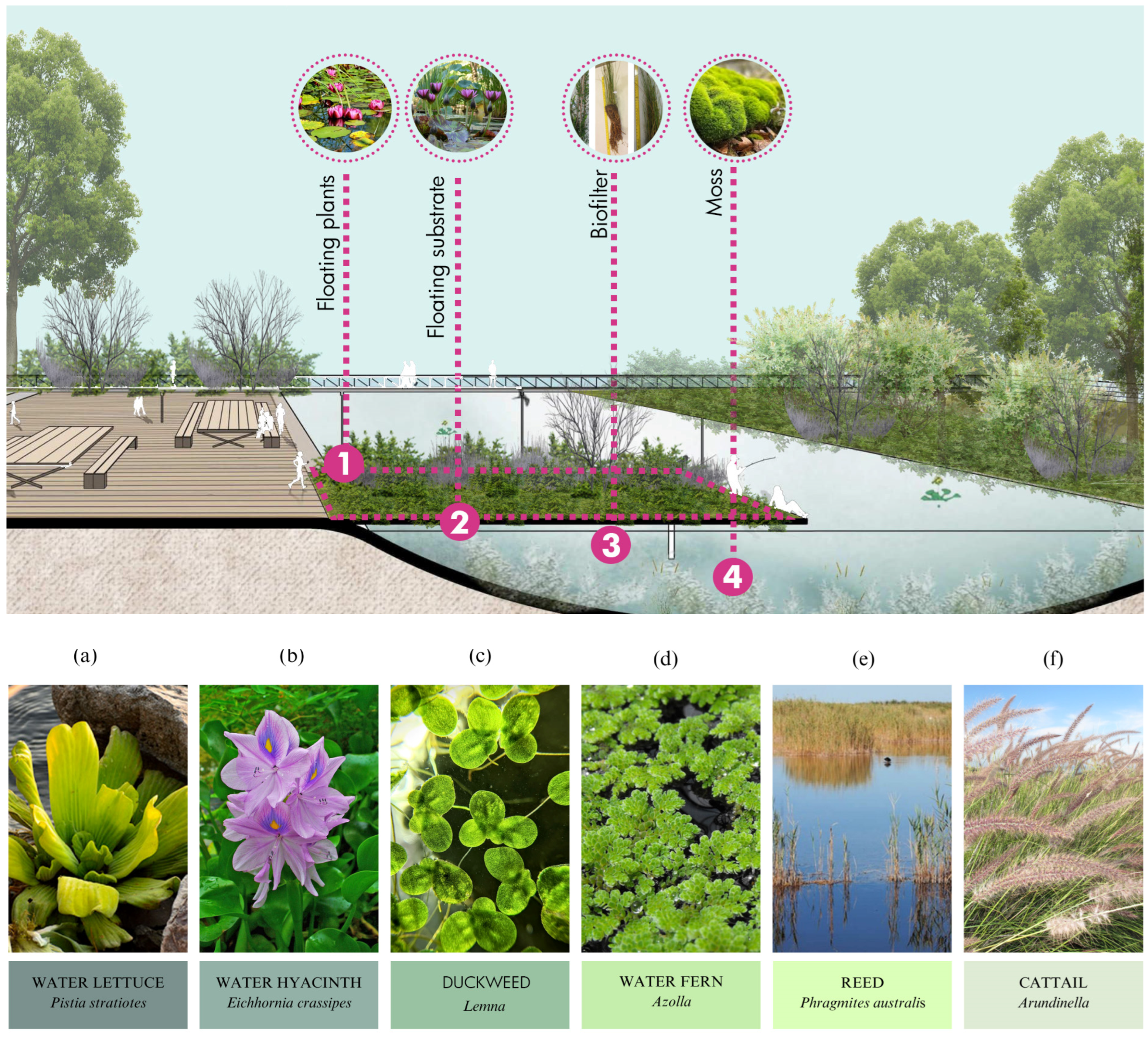
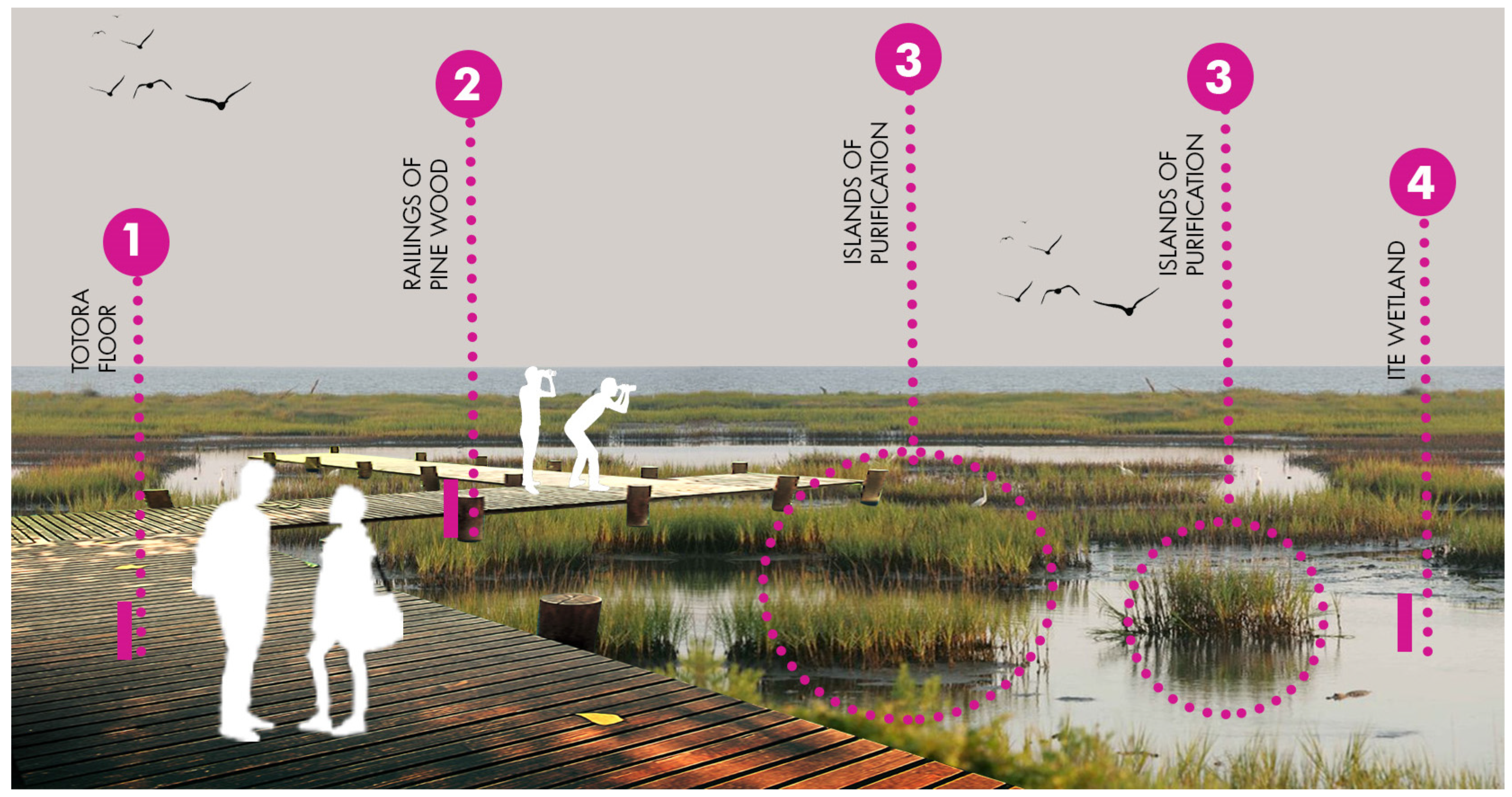
The purification system consists of floating plants, which will help eliminate elements such as nitrogen and phosphorus through absorption. Floating purifying species will include water lettuce, water hyacinth, duckweed, and water ferns. In addition, for metal contamination, other species such as reed and cat’s tail will be implemented for their ability to eliminate lead, and duckweed seed for the elimination of copper (Figure 13) [36].
The floating island system will be composed of the aforementioned species, with a substrate where purifying plants will be planted. Their roots, in contact with water, will develop moss, which will decompose and absorb impurities from the water. To support this process, the innovation of these islands includes biofilters placed beneath them in the form of vertical elements that will help capture more moss.
Each 1 m2 of floating islands has the capacity to purify 11,607.14 cubic meters of water. Therefore, 72,369 m2 of purification islands will be necessary to purify the 840,000,000 cubic meters of water in the wetland, according to the calculations shown (Table 8). In addition to their purifying function, they will have an ornamental purpose and will provide public spaces over the water located adjacent to elevated paths.
Strategic location points for the floating island system will consist of five islands positioned to complement the shape of the trails. These islands not only fulfill an aesthetic function but play a crucial role in landscape functionality and biodiversity, providing additional habitats for various species. Each island is considered a unique microecosystem with its own composition of plants and aquatic and terrestrial habitats, potentially attracting different forms of wildlife. The strategic location of the islands can also influence the hydrological dynamics of the area, affecting water flow and the quality of surrounding aquatic habitats. Islands can serve as focal points for recreation and environmental education, allowing visitors to explore and learn about the biodiversity of the area. It is important to consider the size and shape of each island in relation to its surroundings, ensuring that it does not obstruct natural pedestrian traffic or water circulation. Including islands in landscape design can also help mitigate negative environmental impacts, such as soil erosion and pollutant leaching (Figure 14).

3.9.2. Birdlife Viewpoints

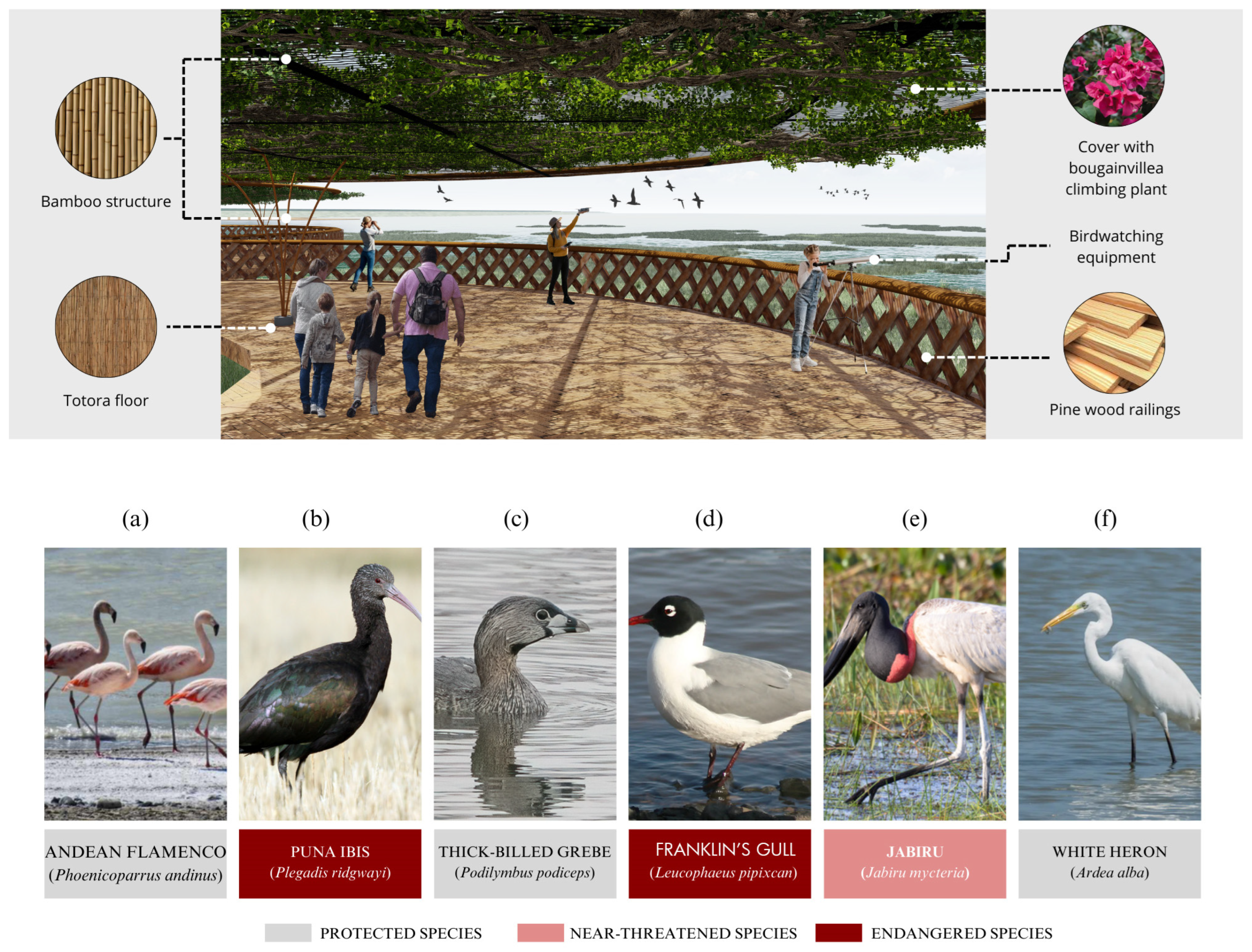
The birdwatching observatories will be strategically placed spaces allowing people the study and admiration of species in their natural habitat without disturbing their environment. These observatories are designed to offer panoramic views of the area, equipped with seating, observation equipment, and informational panels about the various species present. Additionally, trained staff will be available to provide further information about local birds and assist visitors in identifying the birds they observe. Threatened bird species in Ite include the Andean ibis (Plegadis ridgwayi) and the Franklin’s gull (Leucophaeus pipixcan). The jabiru (Jabiru mycteria) is another at-risk species because of threats to its breeding sites, as it uses only two types of trees, the ceiba and the white guanacaste, for nesting. Protected birds such as the Andean flamingo (Phoenicoparrus andinus), the pied-billed grebe (Podilymbus podiceps), and the great egret (Ardea alba) are monitored and protected (Figure 15).
The birdwatching platforms will be positioned at a height of 5 to 7 m above the water. These platforms will be constructed with flooring made from totora and bamboo, both natural materials known for their flexibility and durability. Bougainvillea glabra vines will be planted on the roofs for their ornamental beauty, rapid coverage, resistance to the warm climate typical of Ite, low maintenance requirements, shade provision, and natural cooling effect [37,38]. Additionally, a series of platforms will be constructed along the linear park to host various activities. Furthermore, the incorporation of vegetative coverings with climbing plants in certain areas is planned, not only to provide shade and shelter for local wildlife but to enhance the visual appeal of the environment and promote biodiversity.

3.9.3. Interpretive Trails

Meandering paths are projected to form a circuit designed to navigate the wetland, offering visitors an immersive experience in nature. These trails will be carefully planned, connecting various areas of the wetland and providing access to its natural riches from multiple viewpoints, allowing visitors to explore and observe all the flora and fauna of the area.

3.9.4. Cycle Paths

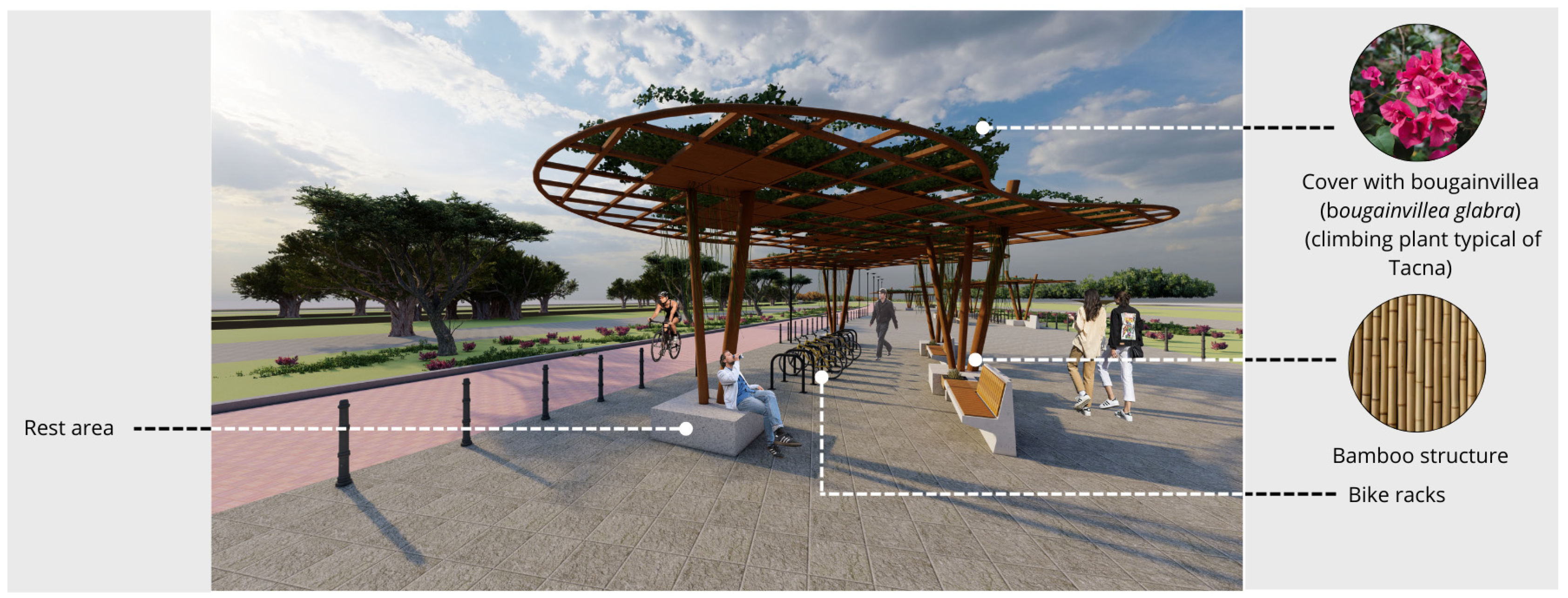
Routes equipped with bike lanes will be included along the corridor for those who prefer to explore by bicycle, promoting ecological transportation and greater accessibility for all visitors. In addition, rest areas will be strategically located every 1 km, providing relaxation spaces where visitors can stop and admire the surroundings. These rest areas will integrate with the natural environment, offering benches and shaded areas where visitors can enjoy moments of tranquility while soaking in the serenity of the wetland. According to the National Building Regulations of Peru, for every 25 people there must be a parking lot measuring 5 × 2.48 m, which is why, to cover the total capacity demand, 688 parking spaces are necessary. These will be placed in the upper part of the building. beginning of the tour. Likewise, the project will have parking areas for bicycles distributed every 1000 m. This arrangement will facilitate a continuous tour that will allow users to appreciate the beauty and comprehensive design of the project in its entirety.
The use of local materials such as bamboo for the structure, bougainvillea vines for the coverage, and wooden railings will also be observed (Figure 16). The proposal includes the use of recycled materials for other design components, such as side panels or fastening systems. Incorporating recycled materials not only reduces the demand for natural resources but helps in reducing waste and promoting sustainable practices. Additionally, permeable materials will be used for the surrounding pavements, which will allow for better management of rainwater and a lower environmental impact compared with conventional pavements.

3.9.5. Solar Panels

Solar panels will be integrated into lighting fixtures within a green infrastructure proposal. They possess various features [39]:
  • Sustainability: They harness renewable and clean solar power, decreasing reliance on nonrenewable energy sources and aiding in the reduction of climate change impacts [40].
  • Energy Efficiency: Solar panels effectively transform solar energy into electricity, enabling the luminaires to function with reduced energy usage [41].
  • Low Maintenance: Once installed, solar panels require minimal maintenance, which reduces long-term operational costs.
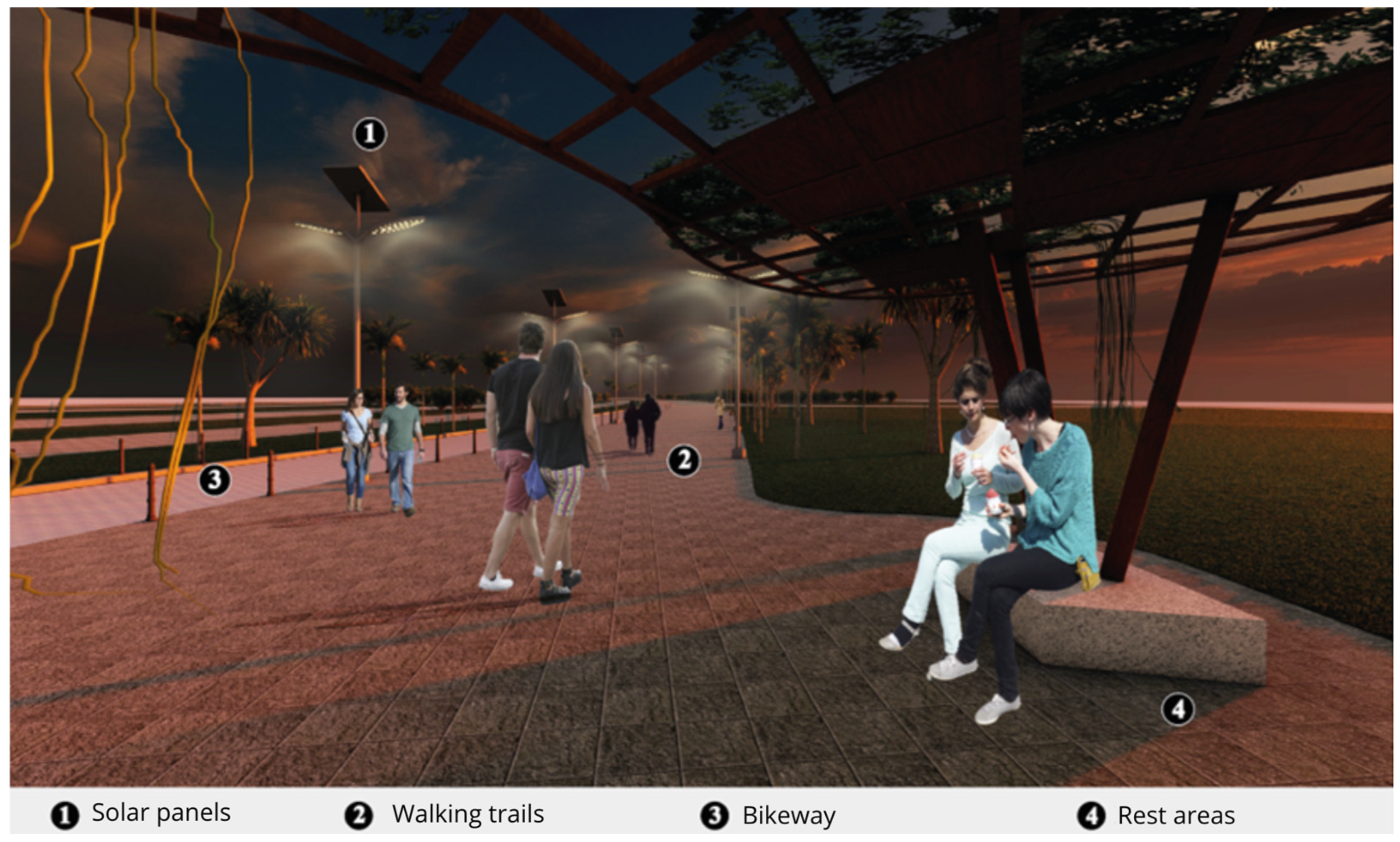
Solar panel luminaires will be deployed throughout the pathway of the infrastructure (Figure 17).
  • Circuit 1 spans 6 km and features the installation of 200 lights equipped with photovoltaic panels.
The execution will have an independent lighting system that will provide a viable, high-quality solution to illuminate streets, communal spaces, and shared areas within the proposal at night. This system directly replaces sodium, mercury and metal halide lamps, complying with Icontec, Retilap, UL, and CE standards (Table 9).
The lamps will have a power of 120 W, a luminous intensity of 14,400 lumens, and a flux of 120 lumens per watt. They will feature a color temperature of 6500 K and operate with a deep cycle battery, providing 12 h of continuous use. The recommended installation height is 11 to 12 m, with posts spaced 25 to 28 m apart.
These highly efficient solar panels are capable of converting up to 23% of solar power into electrical power and are strategically positioned along the primary route to optimize sunlight exposure throughout the day. The energy collected is subsequently transferred to batteries or retained in an energy storage system for later use, especially at night or during overcast days when solar availability is low. The project features a modular and flexible design that facilitates installation in various environments, from urban areas to rural zones, promoting more efficient and environmentally friendly lighting. This system not only contributes to sustainability by harnessing renewable energy sources but decreases reliance on nonrenewable energy sources, offering an ecological and cost-effective alternative. Furthermore, its adaptability allows for integration into a wide range of infrastructures and landscapes, optimizing energy consumption and minimizing environmental impact [42,43].

3.9.6. Botanical Garden

As a habitat recovery strategy, the design of gardens with native plants selected to benefit both local wildlife and migratory species is proposed (Figure 18). These gardens will not only provide a crucial refuge for wildlife but serve as breeding grounds, contributing to the restoration and strengthening of local ecosystems [44].
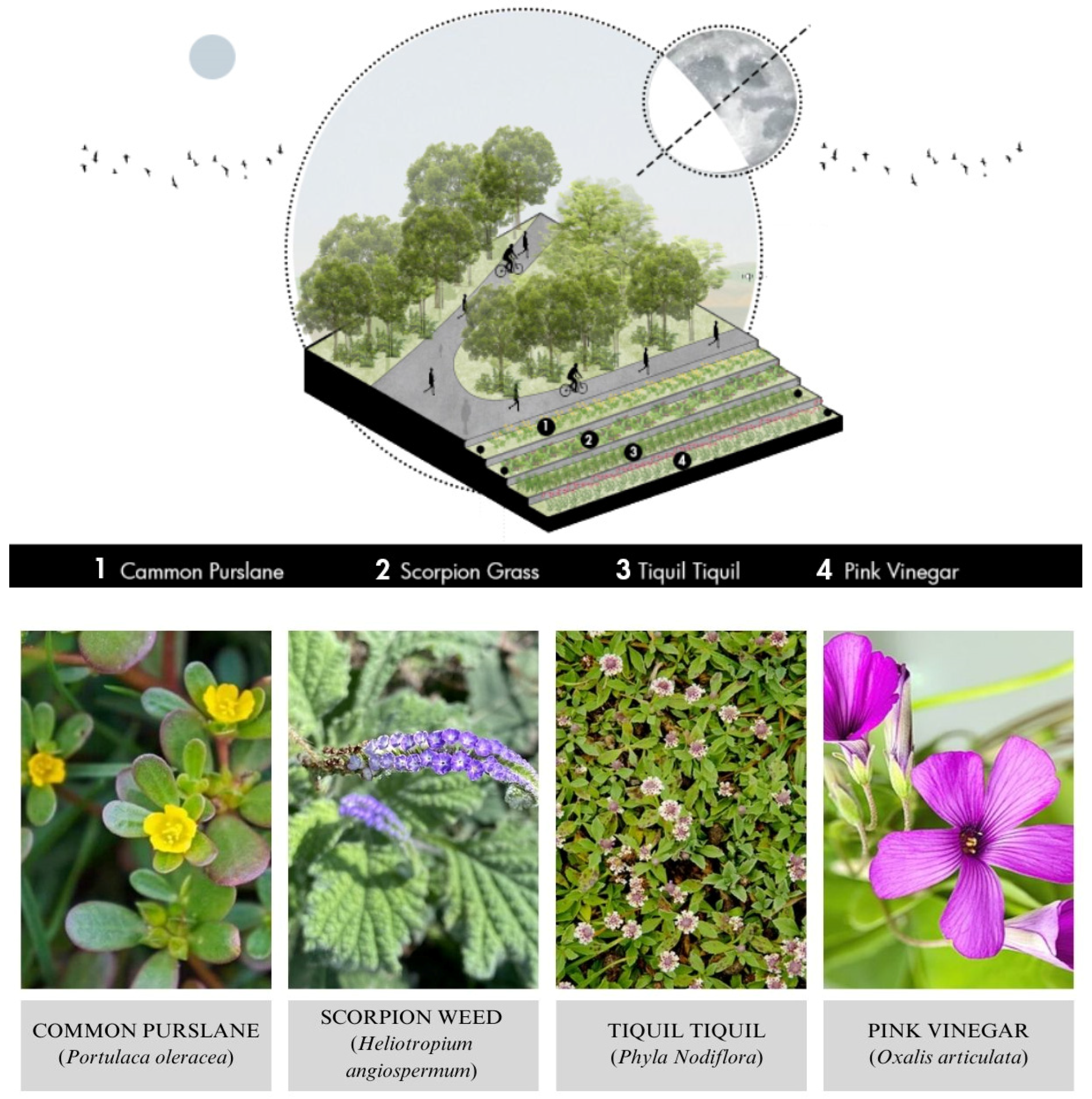
Additionally, educational elements will be integrated into the garden design to promote environmental awareness and appreciation of biodiversity. Informational panels will highlight the features and benefits of native plants, emphasizing their crucial role in ecological balance and the preservation of local flora and fauna. This information will help raise awareness among visitors, inspiring them to actively participate in the conservation of natural habitats and adopt sustainable practices in their own communities. In this way, the gardens will serve not only as spaces of beauty and tranquility but as powerful tools for environmental education and the promotion of biodiversity conservation. The botanical garden will have different species distributed inside. The plant species that will be implemented in the botanical garden located on the platforms are the common verdolaga (Portulaca oleracea), scorpion grass (Heliotropium angiospermun), and pink vinegar (Oxalis articulata), which are medicinal plants, and tiquil tiquil (Phyla Nodiflora), which is an ornamental plant.

3.9.7. Biodrainage System

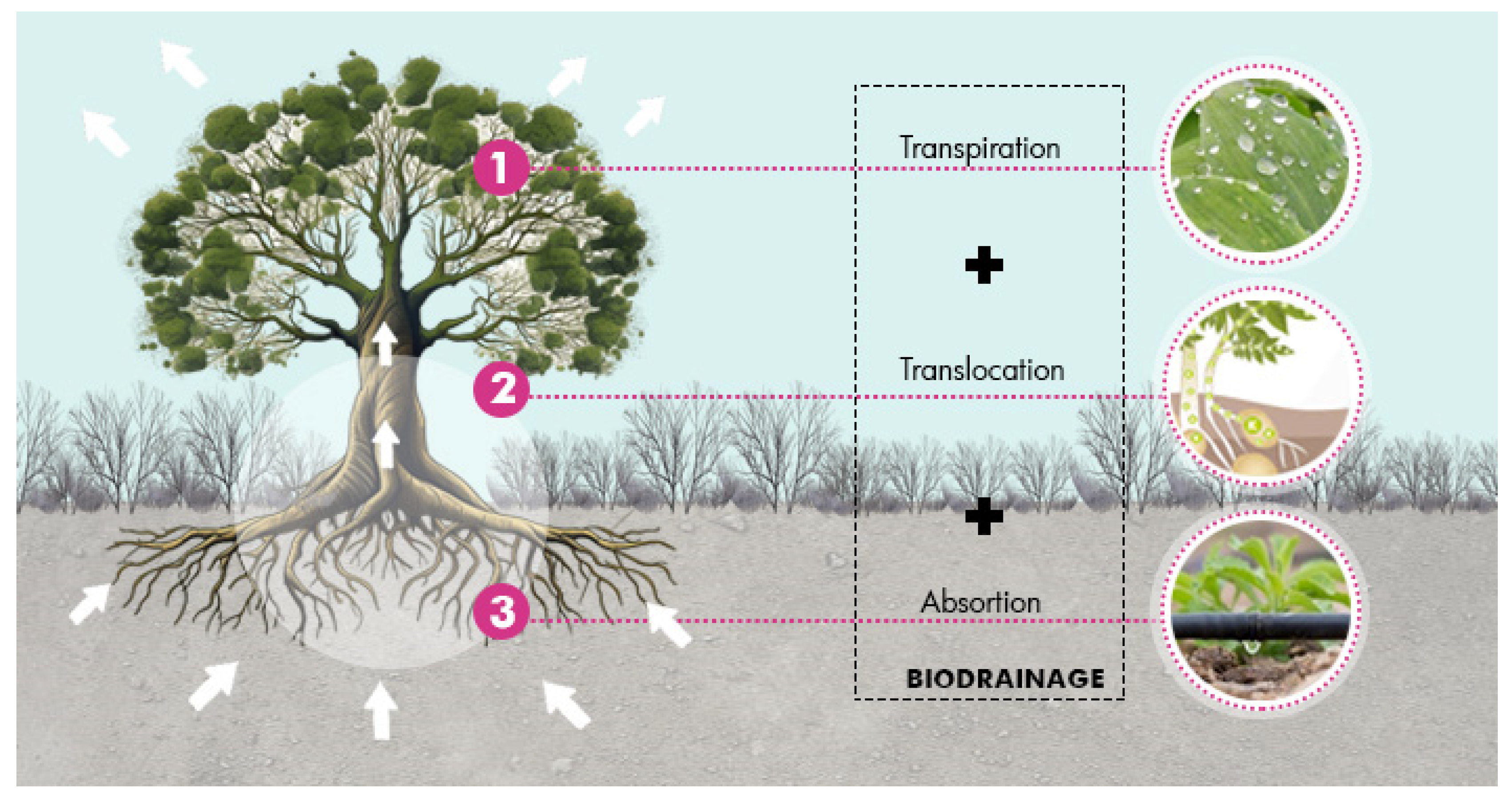
The biodrainage system involves a combined process of absorption, translocation, and transpiration of excess groundwater. For the system to be efficient, trees must grow quickly and have a high transpiration capacity to absorb a sufficient amount of water from the capillary fringe above the water table. The absorbed water is transported to different parts of the plants, and finally, more than 98% of the absorbed water transpires to the atmosphere, mainly through the stomata [45] (Figure 19).
It is important to note that these trees not only help mitigate flooding and waterlogging issues but play a crucial role in groundwater recharge and the regulation of the local hydrological cycle. In ideal conditions, the tree canopy can lower the groundwater level by 1 to 2 m within a relatively short period of 3 to 5 years. This phenomenon illustrates the significant impact that effective implementation of a biodrainage system can have on water resource management and the resilience of urban ecosystems to extreme weather events.
The precise selection of these locations is based on a detailed analysis of local topography, soil absorption capacity, and historical flood frequency. Factors such as proximity to water sources and existing infrastructure are also considered. These biodrainage systems are designed to mitigate flood impacts by allowing efficient absorption of excess water into the soil and redirecting it to natural or artificial drainage systems. Implementing these systems requires careful planning and coordination between local authorities, hydrology experts, and affected communities to ensure effectiveness and long-term sustainability.

3.9.8. Ecomuseum

To protect fauna and other living organisms in the current design, which focuses on birds and plants through the implementation of an ecomuseum, it is essential to consider various aspects of the design, spaces, and environments. In addition, the generation of training workshops to raise awareness in the community is crucial (Table 10).
The training workshops will cover topics such as environmental awareness, with sessions on the importance of biodiversity and conservation; species identification, where participants will be trained in the identification and monitoring of local birds and plants; and sustainable practices, providing instructions on how to contribute to conservation from home and within the community. The methodology will include lectures and seminars with experts in biology and ecology, practical activities such as field trips and wildlife observations, and the use of educational materials such as brochures, guides, and mobile apps to facilitate learning. The benefits of these workshops will include biodiversity conservation, increasing the population of local species; education and awareness, enhancing environmental knowledge within the community; and ecosystem improvement, contributing to the regeneration of local ecosystems and improving air and soil quality.

3.9.9. Responsible Solid Waste Management

In just five steps, municipalities can carry out responsible management of municipal solid waste (Figure 20):
  • Minimization of waste and efficiency in materials;
  • Segregation of solid waste at the source;
  • Selective collection of solid waste;
  • Waste recovery;
  • Final disposition.
Minimizing waste and improving material efficiency are fundamental to the sustainable management of solid waste, as they involve reducing the amount of waste generated from design through operation, prioritizing durable and reusable materials. Waste segregation at the source is essential for facilitating recycling and reuse by properly separating organic, recyclable, and nonrecyclable waste. Selective waste collection, through the implementation of differentiated collection systems, ensures that recyclable and organic materials are transported to specialized treatment facilities, thus reducing the burden on landfills. Finally, waste valorization transforms waste into useful resources, such as energy or recycled materials, promoting a circular economy that minimizes environmental impact and optimizes the use of natural resources. These integrated practices not only contribute to environmental sustainability but offer potential economic and social benefits by creating jobs and fostering innovation in waste management.

4. Discussion

The Ite wetlands project, which promotes natural heritage conservation and the use of renewable energy, exemplifies how NbS can be integrated into urban planning in areas vulnerable to climate change. This project is similar to the Minghu Wetland Park project, which aims to restore degraded natural spaces through the design of infrastructure such as bike lanes and rest areas. In Ite, the creation of trails over the water has been avoided to prevent disturbance to the aquatic ecosystem. Moreover, the Ite project focuses on wetland preservation, environmental education, and recreation, utilizing sustainable green infrastructure and stormwater management systems to improve water quality. This approach underscores the importance of conserving urban wetlands as essential elements for climate change mitigation and urban resilience enhancement.
The Laguna Carpintero Wetland Revitalization and Conservation Project also follows ecological recovery strategies [46]. In this case, urban expansion is not encouraged; rather, the aim is to create a safer environment for local and migratory wildlife, with architecture adapted to the territory to preserve existing habitats. The project includes stormwater management systems and biofilters, as well as the creation of buffer zones through vegetation, ensuring long-term sustainability and ecosystem health via environmental monitoring technologies.
In Latin America, the Circumferential Garden of Medellín stands out as a key initiative to integrate disadvantaged neighborhoods on the slopes of the Aburrá Valley, addressing challenges of marginalization and ecological vulnerability. Since 2008, Medellín has implemented green strategies, including the creation of a green belt and the restoration of 42 hectares, with community participation in planting agroecological gardens. These actions seek to improve quality of life despite challenges such as unemployment and family relocation, among others.
The mentioned projects demonstrate how urban planning can reconcile development with environmental conservation. Green corridors provide an all-encompassing solution to the issues associated with urban expansion, as seen in the case of the Ite wetlands [47]. These corridors act as ecological connectors that preserve and expand natural habitats, improving connectivity between aquatic and terrestrial ecosystems. In Ite, the corridors can enhance water quality, reduce runoff, and provide habitats for local flora and fauna, in addition to offering recreational and educational spaces for the community, strengthening resilience to extreme weather events [48,49,50].
The successful implementation of these projects highlights the importance of a sequential approach to integrating large-scale urban initiatives, managed by local governments with plans adapted to the specific characteristics of each city. Moreover, promoting citizen participation in urban planning is essential to ensure its effectiveness and inclusivity.

Limitations of the Research

This study provides a comprehensive analysis of the potential of green infrastructure as a strategy for the enhancement of the Ite Wetlands, establishing a solid foundation for future research. However, the scope was influenced by the availability of specific data on the area’s ecological and social dynamics, as well as by the defined geographic and temporal boundaries. These aspects could be complemented in future studies by adopting broader approaches or advanced methodologies that delve deeper into the relationship between landscape proposals and their environmental and social impact.
In this regard, it is suggested that future research explore the implementation of hydrological simulations and climate scenario analyses, in addition to incorporating interdisciplinary perspectives that encompass economic and social dimensions. Strengthening community participation and conducting comparisons with similar international cases could also enrich the development of more context-specific and replicable strategies. This expanded approach will significantly contribute to advancing knowledge on the role of green infrastructure in the sustainable conservation and enhancement of strategic ecosystems such as wetlands.

5. Conclusions

In conclusion, the revaluation and conservation of urban wetlands, as seen in the case of the Ite wetlands, represent a critical intervention within the framework of sustainable urban development. These ecosystems offer multifaceted ecological benefits, such as improved water quality, flood mitigation, and the preservation of local biodiversity. The analyzed projects, such as the Tibabuyes Ecological Wetland Park and the Circumferential Garden of Medellín, highlight the effectiveness of integrating nature-based solutions, such as ecological corridors, elevated pathways, and stormwater management systems, to restore degraded spaces without compromising necessary urban development.
The implementation of green infrastructure in these projects not only provides practical solutions to enhance ecological and climate resilience but creates recreational and educational spaces that promote community well-being. The design of these spaces, adapted to the local context, allows communities to access green areas that foster environmental education and social integration while encouraging active participation in environmental conservation. The experience of Medellín’s Circumferential Garden underscores that, by incorporating ecological rehabilitation alongside improving the quality of life in marginalized neighborhoods, the effects of urban informality and socioeconomic vulnerability can be mitigated, creating a model of inclusive urban development.
On the other hand, the socioeconomic benefits derived from wetland conservation, such as improved quality of life and increased surrounding property values, support the viability of these projects as drivers of local economic development. The integration of environmental monitoring technologies and sustainable resource management reinforces the long-term sustainability of these spaces, ensuring that interventions are not only effective today but resilient to future challenges.
Finally, it is evident that urban planning must adopt a comprehensive approach that combines environmental conservation needs with urban development goals. Public policies should align with these needs, prioritizing the inclusion of green corridors and the rehabilitation of urban ecosystems as essential elements for sustainability. Collaboration among local governments, experts, and communities is crucial to ensure that projects are not only technically solid but able to meet the needs of residents and contribute to strengthening urban resilience to climate change.
This study adds significant value by integrating innovative green infrastructure approaches in the revaluation of urban wetlands, particularly in the context of Ite, Tacna. Unlike previous studies that have addressed wetland conservation in natural environments, this work demonstrates how integrating nature-based solutions within urban development can balance ecological preservation with the needs of sustainable urban growth. It also contributes to science by offering a practical methodology for designing spaces that not only improve biodiversity and climate resilience but promote community participation and environmental education—areas that have been insufficiently explored in prior research. This comprehensive approach expands knowledge on how urban wetlands can become key elements for sustainability, providing a replicable model for other urbanized regions, marking a significant departure from the current state of the art.

Author Contributions

Methodology, V.R., C.V., C.A., S.M., C.J., D.E., E.H., D.F. and P.M.; Validation, V.R.; Investigation, V.R. All authors have read and agreed to the published version of the manuscript.

Funding

This research received no external funding.

Data Availability Statement

The original contributions presented in the study are included in the article, further inquiries can be directed to the corresponding author.

Conflicts of Interest

The authors declare no conflict of interest.

References

  1. RAMSAR. 2015. Available online: https://www.ramsar.org/sites/default/files/documents/library/bn7s.pdf (accessed on 23 January 2024).
  2. Yupanqui, C. MINAM. 2019. Available online: https://www.minam.gob.pe/wp-content/uploads/2019/03/La-ANA-y-la-conservaci%C3%B3n-de-humedales.pdf (accessed on 1 December 2023).
  3. Cuzcano, J. OCEANA. Available online: https://peru.oceana.org/blog/areas-naturales-protegidas-herramientas-de-conservacion-de-ecosistemas-y-especies/ (accessed on 23 January 2024).
  4. Ambiental, S.A. Perú: Conoce los 14 Humedales más Importantes para la Biodiversidad y Supervivencia Humana. AM-BIENTAL, SPDA ACTUALIDAD. February 2022. Available online: https://www.actualidadambiental.pe/14-humedales-mas-importantes-para-la-biodiversidad-y-supervivencia-humana/ (accessed on 11 December 2023).
  5. Aldana Duran, M.I. Biodiversidad y áreas naturales protegidas en la Evaluación de Impacto Ambiental: Avances y temas pendientes. Rev. Kawsaypacha Soc. Medio Ambiente 2022, 34–55. Available online: https://revistas.pucp.edu.pe/index.php/Kawsaypacha/article/view/24640 (accessed on 27 June 2024). [CrossRef]
  6. Zumaeta, A. Análisis de las políticas para la conservación de la biodiversidad en el Perú. Estud. Desarro. Soc. 2023, 11, 174–183. Available online: http://scielo.sld.cu/scielo.php?script=sci_arttext&pid=S2308-01322023000300014 (accessed on 27 June 2024).
  7. Borg Rasmussen, M. Convivencia negociada y gobernanza ambiental en áreas naturales protegidas del Perú. Íconos 2022, 26, 161–183. Available online: https://iconos.flacsoandes.edu.ec/index.php/iconos/article/view/4953 (accessed on 27 June 2024). [CrossRef]
  8. Paz Salinas, M.F. De áreas naturales protegidas y participación: Convergencias y divergencias en la construcción del interés público. Nueva Antropol. 2008, 21, 51–74. Available online: https://www.scielo.org.mx/scielo.php?pid=S0185-06362008000100004&script=sci_arttext (accessed on 27 June 2024).
  9. Riemann, H.; Santes-Alvarez, R.V.; Pombo, A. El papel de las áreas naturales protegidas en el desarrollo local: El caso de la península de Baja California. Gest. Polít. Pública 2011, 20, 141–172. Available online: https://www.scielo.org.mx/scielo.php?pid=S1405-10792011000100004&script=sci_abstract&tlng=pt (accessed on 27 June 2024).
  10. (SERNANP) SNdÁNP. Mapa de Áreas Naturales Protegidas del Perú. 2008. Available online: https://sinia.minam.gob.pe/mapas/mapa-areas-naturales-protegidas-2008 (accessed on 22 August 2024).
  11. El Peruano. Plataforma digital única del Estado Peruano. 2008. Available online: https://www2.congreso.gob.pe/Sicr/AsesJuridica/JURIDICA.NSF/vf06web/FB10F78B170E0E80052573D20075CFC8/$FILE/20080116.pdf (accessed on 23 January 2024).
  12. Maquera, A.E. Análisis de la estimación del valor económico del ecosistema de los humedales de la bahía de ite, región tacna. Cienc. Desarro. 2018, 62–68. Available online: https://revistas.unjbg.edu.pe/index.php/cyd/article/view/759 (accessed on 22 August 2024).
  13. Neira, A.C.; Chambilla Ccosi, A. Historia de la contaminación de la bahía de Ite por la empresa minera Southern Perú. La Vida La Hist. 2019, 70–79. [Google Scholar] [CrossRef]
  14. Radio Uno. 2018. Available online: https://radiouno.pe/noticias/71120/exigen-southern-no-impedir-pastoreo-ganado-rumiante/ (accessed on 1 January 2024).
  15. Minas, M. Ministerio de Energías y Minas. 2006. Available online: https://www.minem.gob.pe/minem/archivos/file/dgaam/publicaciones/curso_cierreminas/02_T%C3%A9cnico/03_Calidad%20de%20Aguas/TecCalAG_Presentaci%C3%B3n.pdf (accessed on 1 January 2024).
  16. Perez, S. Environmental impact of the Southern Peru Copper Corporation Mining Company in Latin America: A historical approach from the Early 20th Century to the present. Rev. Geogr. Am. Cent. 2018, 61, 489–503. [Google Scholar] [CrossRef]
  17. Andina. Tacna: Bomberos Controlan Incendio Forestal en los Humedales de Ite; Andina: Lima, Peru, 2016. [Google Scholar]
  18. López, J.A.S.; Benítez, R.G. Infraestructura verde. Conceptualización y análisis normativo de México. Quivera Rev. Estud. Territ. 2022, 24, 105–128. [Google Scholar]
  19. Higueras-García, E.; Pozo-Menéndez, E.; Moneo-Feduchi, B.; Brock, J. Ordenación territorial desde la infraestructura verde y azul en el Valle de Guatiguará (Colombia) urbe. Rev. Bras. Gestão Urbana 2022, 14, e20210284. Available online: https://www.redalyc.org/journal/1931/193173030034/html/ (accessed on 23 January 2024).
  20. Jurídico Dpde. Diccionario Panshispánico del Español Jurídico. 2014. Available online: https://dpej.rae.es/lema/infraestructura-verde (accessed on 23 January 2024).
  21. ArchDaily. 2015. Available online: https://www.archdaily.cl/cl/764388/parque-del-humedal-minghu-turenscape?ad_medium=gallery (accessed on 23 January 2024).
  22. Quira Medios. El Tiabuyes despues del desaolo ¿Qué ha pasado? Available online: https://www.quira-medios.com/humedal-tibabuyes/ (accessed on 23 January 2024).
  23. Bartorila, M.Á. ResearchGate. 2020. Available online: https://www.researchgate.net/publication/344202968_Sostenibilidad_y_plusvalia_Proyecto_de_revitalizacion_y_conservacion_para_el_humedal_Laguna_del_Carpintero_y_entorno (accessed on 23 January 2024).
  24. Archdaily. Parque del Humedal Minghu. 2015. Available online: https://www.archdaily.cl/cl/764388/parque-del-humedal-minghu-turenscape (accessed on 22 August 2024).
  25. Castillo, N.B. Parque Ecologico Humedal Tibabuyes. 2021. Available online: https://repository.unipiloto.edu.co/handle/20.500.12277/10531 (accessed on 22 August 2024).
  26. Bartorila, M.Á. Proyecto de Revitalización y Conservación para el Humedal Laguna del Carpintero y Entorno. 2020. Available online: https://www.academia.edu/download/82558413/Sostenibilidad_y_plusvalia_DIGITAL_opt.pdf (accessed on 15 December 2023).
  27. Vizcarra, J.K.; Hidalgo, N.; Chino, E. Adiciones a la avifauna de los Humedales de Ite, costa sur de Perú. Rev. Peru. Biol. 2009, 16, 221–226. [Google Scholar] [CrossRef]
  28. Apud, A.; Faggian, R.; Sposito, V.; Martino, D. Suitability Analysis and Planning of Green Infrastructure in Montevideo, Uruguay. Sustainability 2020, 12, 9683. [Google Scholar] [CrossRef]
  29. Sobrinho, O.M.; Rudke, A.P.; Morais, M.V.B.d.; Martins, L.D. Meteorological Effects of Green Infrastructure on a Developing Medium Latin American City: A Numerical Modeling Assessment. Sustainability 2023, 15, 1429. [Google Scholar] [CrossRef]
  30. Redondo Bermúdez, M.d.C.; Kanai, J.M.; Astbury, J.; Fabio, V.; Jorgensen, A. Green Fences for Buenos Aires: Implementing Green Infrastructure for (More than) Air Quality. Sustainability 2022, 14, 4129. [Google Scholar] [CrossRef]
  31. Dorado-Rubín, M.J.; Guerrero-Mayo, M.J.; Navarro-Yáñez, C.J. Integrality in the Design of Urban Development Plans. Analysis of the Initiatives Promoted by the EU in Spain. Land 2021, 10, 1047. [Google Scholar] [CrossRef]
  32. Álvez, A.; Espinosa, P.; Castillo, R.; Iglesias, K.; Bañales-Seguel, C. An Urgent Dialogue between Urban Design and Regulatory Framework for Urban Rivers: The Case of the Andalién River in Chile. Water 2022, 14, 3444. [Google Scholar] [CrossRef]
  33. Ramirez Lopez, L.J.; Grijalba Castro, A.I. Sustainability and Resilience in Smart City Planning: A Review. Sustainability 2021, 13, 181. [Google Scholar] [CrossRef]
  34. Balsas, C.J.L. Urban Revitalization in Small Cities across the Atlantic Ocean. Sustainability 2024, 16, 639. [Google Scholar] [CrossRef]
  35. Vida, J.; Radicchi, A.; Xiao, J. Urban Design for Sustainable Built Environments. Sustainability 2023, 15, 15493. [Google Scholar] [CrossRef]
  36. Baltazar, O. Sendero interpretativo de orquídeas y bromelias en Tepexilotla, Chocamán, Veracruz. Rev. Mex. Cienc. Agrícolas 2014, 5, 1687–1699. [Google Scholar] [CrossRef]
  37. Esenarro, D.; Chicche, P.V.; Chichipe, V.A.; Cobeñas, P.; Raymundo, V. Bioclimatic Criteria for a Guest House in the District of Canta—Lima. In Proceedings of the 2022 11th International Conference on Power Science and Engineering (ICPSE), Eskisehir, Turkey, 23–25 September 2022; pp. 1–9. [Google Scholar] [CrossRef]
  38. Esenarro, D.; Malpartida, K.; Silvana, L.; Raymundo, V.; Morales, W. Use of Renewable Energies Applied in Design Strategies for User Comfort in a House in Iquitos-Belen. In Proceedings of the 2022 11th International Conference on Power Science and Engineering (ICPSE), Eskisehir, Turkey, 23–25 September 2022; pp. 135–141. [Google Scholar] [CrossRef]
  39. Cabezas, M.; Franco, J.; Fasoli, H. Diseño y evaluación de un panel solar fotovoltaico y térmico para poblaciones dis-persas en regiones de gran amplitud térmica. Ing. Investig. Tecnol. 2018, 19, 209–221. [Google Scholar] [CrossRef]
  40. Herman, F.; Martinez, A.; Guzman, V.; Gimenez, M. Obtención de la máxima potencia en paneles fotovoltaicos me-diante control directo: Corriente a modulación por ancho de pulsos. Univ. Cienc. Tecnol. 2006, 10, 134–138. Available online: http://ve.scielo.org/scielo.php?script=sci_arttext&pid=S1316-48212006000300009&lng=es&nrm=iso (accessed on 8 December 2023).
  41. Novoa, J.E.; Alfaro, M.; Alfaro, I.; Guerra, R. Determinación de la eficiencia de un mini panel solar fotovoltaico: Una experiencia de laboratorio en energías renovables. Educ. Química 2020, 31, 22–37. [Google Scholar] [CrossRef]
  42. Gómez, A.; Esenarro, D.; Martinez, P.; Vilchez, S.; Raymundo, V. Thermal Calculation for the Implementation of Green Walls as Thermal Insulators on the East and West Facades in the Adjacent Areas of the School of Biological Sciences, Ricardo Palma University (URP) at Lima, Peru 2023. Buildings 2023, 13, 2301. [Google Scholar] [CrossRef]
  43. Esenarro, D.; Rodriguez, C.; Arteaga, J.; Garcia, G.; Flores, F. Sustainable Use of Natural Resources to Improve the Quality of Life in the Alto Palcazu Population Center, Iscozazin-Peru. Int. J. Environ. Sci. Dev. 2021, 12, 146–150. [Google Scholar] [CrossRef]
  44. Raymundo, V.; Mansilla, S.; Esenarro, D.; Vargas, C.; Huerta, E.; Fernandez, D.; Martinez, P. Self-Sustainable Modular Design in Rural Housing and Experiential Tourism in El Callejón de Conchucos. Ancash. Urban Sci. 2024, 8, 138. [Google Scholar] [CrossRef]
  45. Pavas, J.D. Biodrenaje una Revisión; Informe; Universidad Nacional de Colombia: Bogotá, Colombia, 2019. [Google Scholar]
  46. Ruiz-Apilánez, B.; Ormaetxea, E.; Aguado-Moralejo, I. Urban Green Infrastructure Accessibility: Investigating Environmental Justice in a European and Global Green Capital. Land 2023, 12, 1534. [Google Scholar] [CrossRef]
  47. García, A.M.; Santé, I.; Loureiro, X.; Miranda, D. Spatial Planning of Green Infrastructure for Mitigation and Adaptation to Climate Change at a Regional Scale. Sustainability 2020, 12, 10525. [Google Scholar] [CrossRef]
  48. De Almeida, J.R.; Nunes, R.d.O.; Dias, T. People Prefer Greener Corridors: Evidence from Linking the Patterns of Tree and Shrub Diversity and Users’ Preferences in Lisbon’s Green Corridors. Sustainability 2021, 13, 13228. [Google Scholar] [CrossRef]
  49. de Almeida, J.R.; Alves, G.B.M.; Nunes, R.d.O.; Dias, T. Despite Being Distinguished as the 2020 European Green Capital, Lisbon Has Lost Public Green Areas over the Previous Decade. Sustainability 2022, 14, 12112. [Google Scholar] [CrossRef]
  50. Caparrós-Martínez, J.L.; Milán-García, J.; Rueda-López, N.; de Pablo-Valenciano, J. Green Infrastructure and Water: An Analysis of Global Research. Water 2020, 12, 1760. [Google Scholar] [CrossRef]
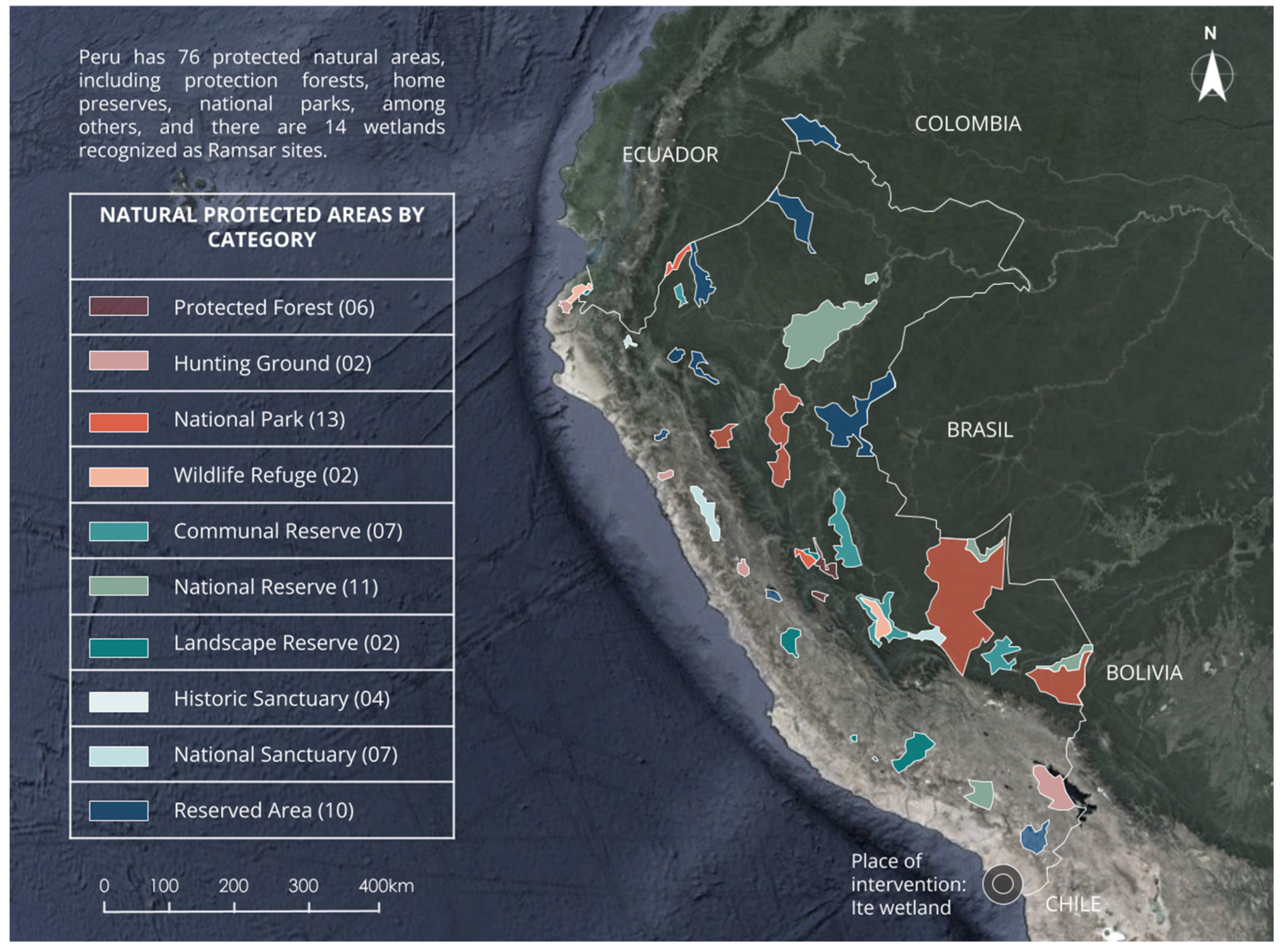
Figure 1. Map of protected natural areas of Peru adapted with permission from Ref. [10].
Buildings 15 00355 g001
Figure 2. Ite Bay before mining exploitation in 1955. Degradation of the wetland over the years from 1955–1999.
Buildings 15 00355 g002aBuildings 15 00355 g002b
Figure 3. (A) Minghu Wetland Park Reprinted with permission from Ref. [24], (B) Tibabuyes Wetland Ecological Park, Colombia Reprinted with permission from Ref. [25], (C) Laguna del Carpintero Wetland, Mexico Reprinted with permission from Ref. [26].
Buildings 15 00355 g003
Figure 4. Structure of the implemented methodology (Phases 1–5).
Buildings 15 00355 g004
Figure 5. Comparative evaluation table by educational center.
Buildings 15 00355 g005
Figure 6. Location of the Ite wetlands.
Buildings 15 00355 g006
Figure 7. Ite climate analysis.
Buildings 15 00355 g007
Figure 8. Flora and fauna of the wetlands of Ite.
Buildings 15 00355 g008
Figure 9. Map of roads in the district of Ite.
Buildings 15 00355 g009
Figure 10. Land use map in Ite. Uses mainly include agricultural, residential, commercial, and recreational areas.
Buildings 15 00355 g010
Figure 11. Vulnerability map in Ite.
Buildings 15 00355 g011
Figure 12. Master plan outlining the design strategies.
Buildings 15 00355 g012
Figure 13. Operating scheme of floating islands. Purifying floating plants: (a) Pistia stratiotes; (b) Eichornia crassipes; (c) Lemna; (d) Azolla; (e) Phragmites australis; (f) Arundinella.
Buildings 15 00355 g013
Figure 14. View of floating islands.
Buildings 15 00355 g014
Figure 15. Bird species in the wetland. (a) Phoenicoparrus andinus; (b) Plegadis ridgwayi; (c) Podilymbus podiceps; (d) Leucophacus pipixcan; (e) Jabiru myeteria; (f) Ardea alba.
Buildings 15 00355 g015
Figure 16. Materiality of bicycle parking lots.
Buildings 15 00355 g016
Figure 17. Installation of solar-powered lights.
Buildings 15 00355 g017
Figure 18. Botanical garden. Medicinal and ornamental plants for the botanical garden.
Buildings 15 00355 g018
Figure 19. Biodrainage system process.
Buildings 15 00355 g019
Figure 20. Solid waste management.
Buildings 15 00355 g020
Table 1. Outline of the first portion of expert interviews in this study.
C1: What urban landscape strategies do you recommend for the revaluation of a wetland, and how can these strategies balance ecological conservation with the needs of sustainable urban development?
ExpertsEcology specialists highlighted the importance of approaches that prioritize the conservation of natural ecosystems through the creation of vegetative buffer zones and the use of native plants that help filter pollution and maintain biodiversity. Urban planners suggested integrating green infrastructure, such as pedestrian paths and bicycle paths, that allow public access in a controlled manner, facilitating environmental education without compromising the natural environment. Architects pointed out that designing recreational and educational spaces around the wetland can foster greater public appreciation and offer sustainable recreational alternatives, thus contributing to the balance between ecological conservation and urban development.
C2: What key steps should be followed for the revaluation and conservation of an urban wetland, and how can these actions be integrated into the urban development plan to maximize both environmental and community benefits?
ExpertsRegarding the key steps for the revaluation of wetlands, ecologists recommended restoring and connecting ecological corridors to improve biodiversity and strengthen surrounding ecosystems. Urban planners emphasized the need to integrate these projects into urban plans, suggesting the implementation of regulations that protect the wetland against future urban expansion and unsustainable activities. Architects proposed a participatory approach that involves the community from the beginning through education programs and collaboration in planning to ensure that conservation actions also reflect social needs, which would maximize the positive impact on both the community and the community. as in the environment.
C3: What are the principles of urban morphology design that can facilitate the revaluation and conservation of ecosystems such as wetlands, and how can these natural areas be integrated into the urban fabric to maximize their ecological and social benefits?
ExpertsFrom the design of urban morphology, ecologists highlighted the conservation of natural landscapes and the need to respect the natural dynamics of the wetland, such as flood cycles and the regeneration of flora and fauna. Urban planners proposed the creation of continuous green areas and the incorporation of vegetation as a structural element of the urban space, which would facilitate the integration of wetlands into the urban fabric. Architects suggested incorporating biophilic and sustainable design principles, which would allow the wetland to be visually and functionally connected with the urban environment, thus maximizing social benefits by creating spaces that improve well-being and interaction between residents and nature.
Table 2. Outline of the second portion of expert interviews in this study.
C1: Why is the revaluation of ecosystems such as wetlands crucial in the context of sustainable urban development, and what ecological, social, and economic benefits can be derived from their conservation and integration into the urban fabric?
ExpertsSpecialists in ecology, urban planning and architecture agreed that the revaluation of urban wetlands is essential because of their multiple benefits. Ecologically, wetlands act as natural climate regulators by capturing carbon and filtering water, reducing flood risks and protecting biodiversity. From a social approach, some experts highlighted that these ecosystems provide recreational and educational spaces that promote a greater connection of people with nature and an improvement in the quality of life. In economic terms, wetlands integrated into urban development offer cost-effective solutions for water management and flood control, reducing gray infrastructure costs and promoting a sustainable city model. Overall, the revaluation and integration of wetlands into the urban fabric balances environmental and social well-being with economic benefits, aligning with sustainable development objectives.
C2: What are the main components and strategies of an urban design planned around sustainability, and how can they be effectively implemented to balance urban development with environmental conservation?
ExpertsFrom different perspectives, specialists highlighted key components such as green infrastructure, ecological corridors, and sustainable public spaces. Architects and urban planners highlighted the importance of ecological corridors that allow the connectivity of wetlands with other natural areas, facilitating the movement of species and preserving biodiversity in urban environments. In addition, they considered the implementation of sustainable materials and renewable energy technologies to be essential to reduce environmental impact. Ecologists and urban planners proposed the inclusion of buffer zones with native vegetation, which not only contribute to conservation but increase the aesthetic appeal of the city. To implement these strategies, they recommendd integrated planning, local policies that promote green construction, and educational programs that raise community awareness about the importance of green spaces.
C3: What are the main strategies for designing and planning an urban environment that can adapt to and recover from extreme weather events and natural disasters, and how can these strategies be integrated into urban development to maximize community resilience?
Experts To create cities adapted to extreme climate events, specialists suggested design approaches that integrate both green and gray infrastructure. Architects and urban planners advocated the use of sustainable drainage systems and water retention spaces in high-risk areas, which can mitigate flooding and manage water efficiently. Ecologists emphasized the need to protect wetlands as natural barriers against storms and their effects, while some urban planners proposed incorporating buffer zones and evacuation areas around these ecosystems. To maximize resilience, they highlighted the importance of flexible urban regulations that allow rapid adaptation to new climatic conditions and the development of environmental education programs that prepare local communities to face natural disasters.
Table 3. List of specialists with whom interviews were conducted.
List of Specialists with Whom Interviews Were Conducted
Manuel Emilio Zavala BarredaArchitect specialized in sustainable design and construction, with a focus on creating innovative spaces in harmony with the natural environment, applying the “ecosophy of architectural landscaping”. He has led notable projects such as the “Plaza del Sol, Beach, Health and Wellness Resort”, which has been recognized for its sustainability, and has worked on social housing awarded by the Ministry of Housing of Peru. In addition, he advises public and private entities on sustainable practices and has been a speaker at international universities. His work has been recognized by the College of Architects of Peru and the United Nations for his contribution to ecofriendly housing.
Gerardo Manuel Ángel Vento FigueroaArchitect with a solid academic background and experience in urban projects, with a Master’s in architecture and a doctorate in environment and sustainable development. With a comprehensive approach, he combines his knowledge in architectural design with sustainable strategies for urban development. He has led and participated in various urban planning and regeneration projects, prioritizing solutions that balance the growth of cities with environmental preservation and social well-being. His trajectory is characterized by the application of sustainable principles and commitment to improving the quality of life in urban environments.
Lorena del Rocio Castañeda RodríguezArchitect specialized in sustainability, with training in project management, sustainable urban planning, and environmental design. He has led sustainable housing projects, standing out for his innovative and environmentally responsible approach, as demonstrated by his honorable mention in the National Social Housing Prototype Competition. He is dedicated to promoting sustainable practices in architectural design and urban planning. Currently, he is pursuing doctoral studies and is a member of the ASCE Architectural Engineering Institute.
Walter Morales LlanosArchitect who graduated from the Federico Villarreal National University with a Master’s degree in architecture with a mention in business management. Interested in the design of minimalistic housing, the development of friendly and sustainable cities, and the promotion of healthy environments, with a focus on implementing innovative and efficient solutions that adequately respond to specific problems and integrating strategies that promote the quality of urban life, environmental sustainability, and collective well-being.
Jesús Abel Peña ChávezArchitect and sculptor with a sustainable approach. A graduate in architecture with a qualification of excellence from the FAU-URP (1997) and a disciple of the teacher Carlos Galarza. Noted for his academic and professional work, he is a specialist in light structures, biomimetics, and advanced design, areas that promote efficient and sustainable architectural solutions. Director of the seventh Latin American Symposium on Technostructures (2018) and member of the scientific committee of the Latin American Network of Tensile Structures, he has led projects such as the “Teatina Quincha Shelter”, presented at the National Museum of Beijing and published in Harvard Design Magazine (2011). He has obtained international recognition in competitions and conferences such as IASS and SLTE, with five first places, and completed a Master’s degree in higher education with a mention in research (2021). He currently directs the “Carlos Galarza” Sculpture and Ceramics Workshop, where he integrates sustainability into artistic research, and advises the Institute of Ethnoarchitecture.
Rosemary Bedoya GomezProject manager with experience in the health sector and hospital architecture, specialized in the planning, coordination, and execution of sustainable infrastructure projects in the field of EsSalud and the Ministry of Health of Peru. Currently, her works as investment coordinator of the Program for the Creation of Integrated Health Networks (PCRIS). Previously, she was an architect in the Submanagement of Definitive Studies at EsSalud, where she led hospital architecture and investment management projects. Her training includes a Master’s Degree in Modern Construction Management from the Universidad Nacional Federico Villarreal. Her focus is on the implementation of sustainable and efficient solutions in the construction and management of hospital projects, promoting a positive impact on public health and the environment.
Karla Castillo TrejoArchitect with a Master’s degree in architecture and sustainability, specialized in sustainable urban planning, with extensive experience in the formulation of urban development plans and execution of works with a sustainable approach. Her career combines deep knowledge in urban planning with innovative design and construction practices, promoting solutions that harmonize urban growth with environmental conservation and social well-being.
Rodolfo Alejandro Palacios UcharicoArchitect with an outstanding professional and academic career, with a Master’s degree and a second specialty in sustainable urbanism. His experience covers the design, planning, and execution of works, with a focus on urban projects that integrate principles of sustainability and efficiency. He has led initiatives that prioritize development balanced among infrastructure, urban environment, and environmental care, contributing to improving the quality of life in cities. His comprehensive vision and ability to manage works position him as a professional committed to the sustainable transformation of the built environment.
Abraham Barros CruzArchitect and infrastructure consultant for the licensing of the public and private institutes DISERTPA, DIGESUTPA, PMESUT, and DRELM at the Ministry of Education (MINEDU). He has a Master’s in architecture and sustainability and experience in the management and evaluation of real estate and urban projects, always with a focus on sustainability and responsible development. He has a solid ability to lead and coordinate multidisciplinary teams, supported by his experience in technical areas. His knowledge in public management and contracting with the state is aimed at implementing efficient and sustainable solutions, promoting practices that respect the environment and promote social and environmental well-being in each project.
Ethel Yuvidsa Castillo PalaciosHer leads projects at the Ministry of Foreign Affairs of Peru, where she applies her knowledge in 3D Studio Max and AutoCAD to develop innovative and sustainable designs. Previously, at EXPODECO, she strengthened her expertise in the development of real estate projects with a comprehensive sustainability approach. Her professional approach focuses on promoting architecture that respects and enhances the natural environment, prioritizing energy efficiency, responsible use of resources, and long-term functionality.
Kenti Cusi Coillor Valderrama OrbegosoConsultant on environmental issues with experience in strategic planning, inspection and environmental management at the national level, highlighting her work in the Ministry of the Environment (MINAM) and the Environmental Assessment and Control Agency (OEFA). Expert in the formulation and updating of environmental planning instruments, interinstitutional coordination, and design of regulatory and administrative processes. Her led the general coordination of eight deconcentrated offices of the OEFA, strengthening environmental oversight in regions. She has developed strategic proposals to improve joint performance between MINAM and its affiliated organizations, optimizing the implementation of sustainable public policies.
Pedro Manuel Amaya PingoConsultant on environmental issues with experience in strategic planning, inspection, and environmental management at the national level, with highlights including his work in the Ministry of the Environment (MINAM) and the Environmental Assessment and Control Agency (OEFA). Expert in the formulation and updating of environmental planning instruments, interinstitutional coordination, and design of regulatory and administrative processes. He led the general coordination of eight deconcentrated offices of the OEFA, strengthening environmental oversight in regions. He has developed strategic proposals to improve joint performance between MINAM and its affiliated organizations, optimizing the implementation of sustainable public policies.
Maria Veliz GaragattiShe has management experience in environmental planning, with highlights including her work in the General Directorate of Forestry and Wildlife of the Agricultural Sector, in the General Management of the USAID/PERU Scholarship Association, and as Executive Director of the Civil Association for Ecodevelopment, Environment, and Reforestation (EDMAR). Currently, she is a teacher in the Master’s and doctoral programs at the Graduate School of the Inca Garcilaso de la Vega University, where she promotes the integration of sustainable strategies in academic and professional training.
Violeta Vega VentosillaConsultant in Environmental Impact Studies (EIA) and Environmental Adequacy and Management Programs (PAMA), with a comprehensive approach towards sustainability and conservation of natural resources. In addition, she works as a university professor at the Faculty of Geographic, Environmental, and Ecotourism Engineering of the Federico Villarreal National University, where she promotes the training of professionals committed to sustainable development. She contributes with publications in indexed journals focused on applied research for environmental protection and responsible management of natural resources.
Andres Enrique Camargo NapaicoEcotourism engineer with specialization in landscape design and urban arboriculture, with a focus on the development of sustainable projects that integrate bioclimatic architecture and structural analysis. Throughout his career, he has worked on the design and execution of landscape projects, incorporating 3D modeling, budgets, costs, measurements, and valuations for civil works. As a field supervisor, he has participated in various building projects, always with the vision of creating urban spaces that promote sustainability and respect for the environment. He handles tools such as ArcGIS, AutoCAD, Revit, SketchUp, Lumion, Adobe Photoshop, Excel for engineering, Power BI, and S10, allowing him to efficiently manage each phase of the project, ensuring that his designs contribute to the creation of sustainable cities that harmonize with the natural and urban environment.
Table 4. Determination of indicators.
VariablesDimensionIndicators
1Variable
Independent
Urban Landscape StrategyGreen infrastructureCoverage of green spaces
2Biodiversity
3Urban morphologyUrban density
4Accessibility
5Variable
Dependent
RevaluationSustainabilityEfficiency
6Quality of life
7ResilienceAdaptation to climate change
8Environmental education
Table 5. Survey design.
Questionnaire Design Based on Eight Indicators
1Green infrastructureCoverage of green spacesTo what extent do you agree with the following statement? ”In our rural area, the coverage of green spaces (such as parks, gardens, or natural areas) is adequate for our needs”.
  • Strongly disagree
  • Disagree
  • Neutral
  • Agree
  • Strongly agree
2BiodiversityTo what extent do you agree with the following statement? “Biodiversity in our rural area (including plants, animals, and natural habitats) is maintained in good condition and is sufficient for our needs”.
  • Strongly disagree
  • Disagree
  • Neutral
  • Agree
  • Strongly agree
3Urban morphologyUrban densityTo what extent do you agree with the following statement? “The urban density in our rural area (i.e., the amount of construction and population in the area) is adequate and does not negatively impact the quality of life”.
  • Strongly disagree
  • Disagree
  • Neutral
  • Agree
  • Strongly agree
4AccessibilityTo what extent do you agree with the following statement? “Access to essential services and resources (such as transportation, healthcare, and education) in our rural area is adequate to meet our needs”.
  • Strongly disagree
  • Disagree
  • Neutral
  • Agree
  • Strongly agree
5SustainabilityEfficiencyTo what extent do you agree with the following statement? “Green infrastructure in our rural area (such as parks, gardens, and natural areas) is effective in improving the environment and addressing environmental issues, such as water management and air quality”.
  • Strongly disagree
  • Disagree
  • Neutral
  • Agree
  • Strongly agree
6Quality of lifeTo what extent do you agree with the following statement? “An appropriate urban design in our rural area (including space planning, infrastructure, and services) significantly contributes to improving our quality of life”.
  • Strongly disagree
  • Disagree
  • Neutral
  • Agree
  • Strongly agree
7ResilienceAdaptation to climate changeTo what extent do you agree with the following statement? “Our rural area is well-adapted to climate change and has adequate measures to address extreme weather events and their effects”.
  • Strongly disagree
  • Disagree
  • Neutral
  • Agree
  • Strongly agree
8Environmental educationTo what extent do you agree with the following statement? “In our rural area, environmental education is adequate and provides residents with the necessary information to understand and address local environmental issues”.
  • Strongly disagree
  • Disagree
  • Neutral
  • Agree
  • Strongly agree
Table 6. Green infrastructure capacity calculation.
Squares/Viewpoints/Floating Trails (2 m2/Person)Trails
(1.5 m2/Person)
Ecomuseum
(4.5 m2/Person)
Total
Squares/Viewpoints/Floating Trails
50,246 m2
25,123xx25,123
Trails
13,566 m2
x9044x9044
Ecomuseum
1000 m2
xx222222
Total 34,389
Table 7. Analysis and implementation of indicators in architectural design.
VariablesDimensionIndicatorsProposal
1Variable
Independent
Urban Landscape StrategyGreen infrastructureCoverage of green spacesBotanical garden
Interpretive trail
2BiodiversityBirdwatching
Botanical garden
3Urban morphologyUrban DensityInterpretive trail Ecomuseum
4AccessibilityCycle path
5Variable
Dependent
RevaluationSustainabilityEfficiencySolar panels
6Quality of lifeBotanical garden
Cycle path
7ResilienceAdaptation to climate changeWater purification
Solar panels
Biodrainage system
8Environmental educationEcomuseum
Interpretive trail
Solid waste
Table 8. Demand for purifying plant islands in the Ite Wetland.
Purifying Islands (m2)Purified Water Volume (m3)
111,607.14
72,369840,000,000
Table 9. Installation of solar-powered lights in green infrastructure.
Conventional Solar LuminaireLuminaireTraditional Solar Light
Month (30 Days)
Lighting Fixture with Solar Panel
Month (30 Days)
AmountConventional Solar Luminaire
20 Luminaires
Luminaire with Solar Panel
20 Luminaires
C1120 watts/12 h250 watts/12 h14403000200288,000600,000
total 288,000600,000
Table 10. Ecomuseum design criteria.
Ecomuseum Design Criteria.
Design and SpacesConservation Zones and HabitatsBird areaCreate designated areas with native vegetation that provide food and shelter for birds. These zones should be protected from direct human access.
Xerophyte plant areasImplement gardens with plants adapted to arid conditions, providing habitats for insects and small animals.
Ponds and wetlandsIncorporate water bodies that serve as habitats for amphibians, reptiles, and aquatic birds.
Ecological CorridorsConnectivityDesign green corridors that connect different areas of the ecomuseum, allowing for the safe movement of wildlife.
Diversified vegetationUse a variety of plants to attract and support different species.
EnvironmentsControlled EnvironmentsGreenhousesCreate greenhouses for sensitive plant species, allowing their growth and study under controlled conditions.
AviariesCreate enclosed spaces where endangered bird species can be studied and protected.
Natural EnvironmentsUrban forestsPlant native trees and shrubs to create microhabitats and enhance biodiversity.
Floral prairiesPlant wildflowers to attract pollinators and other beneficial insects.
Disclaimer/Publisher’s Note: The statements, opinions and data contained in all publications are solely those of the individual author(s) and contributor(s) and not of MDPI and/or the editor(s). MDPI and/or the editor(s) disclaim responsibility for any injury to people or property resulting from any ideas, methods, instructions or products referred to in the content.