Article

Multidimensional Assessment and Planning Strategies for Historic Building Conservation in Small Historic Towns: A Case Study of Xiangzhu, China

1
College of Civil Engineering and Architecture, Zhejiang University, Hangzhou 310058, China
2
College of Civil Engineering, Nanjing Tech University, Nanjing 211816, China
*
Author to whom correspondence should be addressed.
Buildings 2025, 15(19), 3553; https://doi.org/10.3390/buildings15193553
Submission received: 30 August 2025 / Revised: 27 September 2025 / Accepted: 29 September 2025 / Published: 2 October 2025
(This article belongs to the Special Issue Advanced Research on Cultural Heritage—2nd Edition)

Abstract

Historic and cultural towns in China are crucial carriers of vernacular heritage, yet many unlisted historic buildings remain highly vulnerable to urbanization and fragmented governance. This study takes Xiangzhu Town in Zhejiang Province as a case study and develops a multidimensional evaluation framework—integrating value, morphology, and risk—to identify conservation priorities and guide adaptive reuse. The results highlight three key findings: (1) a spatial pattern of “core preservation and peripheral renewal,” with historical and artistic values concentrated in the core, scientific value declining outward, and functional diversity emerging at the periphery; (2) a morphological structure characterized by “macro-coherence and micro-diversity,” as revealed by balanced global connectivity and localized hotspots in space syntax analysis; and (3) differentiated building risks, where most assets are low to medium risk, but some high-value ancestral halls show accelerated deterioration requiring urgent action. Based on these insights, a collaborative framework of “graded management–classified guidance–zoned response” is proposed to align systematic restoration with community-driven revitalization. This study demonstrates the effectiveness of the value–morphology–risk approach for small historic towns, offering a replicable tool for differentiated heritage conservation and sustainable urban–rural transition.

1. Introduction

Historic and cultural towns, as essential spatial carriers of Chinese civilization and regional traditions, play an irreplaceable role in maintaining historical continuity and strengthening cultural confidence [1]. In recent years, the steady advancement of China’s urban–rural heritage protection system has established a multi-level framework encompassing historic cities, towns, villages, districts, and buildings [2]. Within this system, historic and cultural towns—large in number and widely distributed—retain relatively complete traditional forms and community patterns. This makes them particularly valuable for exploring both the authenticity and living transmission of vernacular heritage. Notably, statistics indicate that historic buildings in these towns account for approximately 42% of the national total. Their conservation, therefore, directly affects not only local heritage preservation but also the overall integrity and operational efficiency of the national heritage system [2].
At the macrolevel, national strategies and policies have provided strong institutional support for historic building conservation. Initiatives such as the rural revitalization strategy, urban–rural spatial planning reform, and intangible cultural heritage protection policies have created new opportunities for cultural town conservation [3]. Meanwhile, international heritage discourse has shifted from a narrow focus on material preservation to a broader perspective that emphasizes landscape integrity, community participation, and cultural diversity. This evolution links conservation with sustainable development goals and local revitalization efforts, thereby enriching the value dimensions of heritage protection and offering critical guidance for the integrated conservation and adaptive reuse of small-scale historic settlements [4].
At the microlevel, however, cultural towns continue to face persistent challenges, including incomplete protection coverage, fragmented governance, uneven resource distribution, and limited community engagement [5]. Many potential historic buildings remain excluded from statutory protection, lack stable funding, and have no long-term maintenance mechanisms. As a result, they are vulnerable to demolition or inappropriate alteration during processes of urbanization and land-use change [6]. Moreover, conservation efforts have historically prioritized officially designated sites, legally protected buildings, and core districts. When urban-based spatial analysis or revitalization models are directly applied to cultural towns, they often overlook distinctive features such as the street–alley scale, spatial irregularity, and heterogeneous resident composition. Consequently, some projects have become detached from local needs and cultural logic, undermining conservation effectiveness and sustainability while generating negative outcomes such as functional imbalance, resident displacement, and weakened community networks [7]. From a research perspective, most studies remain case-specific or address isolated technical issues. A comprehensive framework covering the entire process of “assessment–diagnosis–conservation–revitalization–management” has yet to be developed [8,9]. This gap restricts both theoretical innovation and technical support for the holistic conservation and sustainable development of cultural towns.
To address these research and practice gaps, this study takes Xiangzhu Town, a provincial-level historic and cultural town in Zhejiang Province, as a case study, with a particular focus on potential historic buildings not yet under statutory protection. The research makes three main contributions. First, it proposes an innovative multidimensional evaluation system—“value–morphology–risk”—tailored to the characteristics of cultural towns, and derives precise, differentiated planning strategies and adaptive reuse models. Second, it advances methodological practice by integrating field surveys, the Analytic Hierarchy Process (AHP), parameter-optimized space syntax, and GIS-based spatial analysis to systematically assess the value, spatial morphology, and decay risk of potential historic buildings. This enables more accurate identification of conservation challenges. Third, it develops four revitalization models—“government-led,” “enterprise-led,” “community-led,” and “collaborative hybrid”—that combine adaptive functional replacement with traditional construction techniques to explore the organic integration of building conservation with the rural revitalization strategy.
The remainder of this paper is structured as follows. Section 2 reviews existing literature and outlines the study’s significance. Section 3 introduces the study area and data sources. Section 4 presents the research methodology and technical route. Section 5 reports and discusses the results. Finally, Section 6 concludes with key findings and policy recommendations.

2. Literature Review

2.1. Concepts and Evaluation Frameworks for Historic Building Conservation

The theoretical foundations of historic building conservation date back to the early 20th century. In The Modern Cult of Monuments (1903), Riegl systematically articulated the values and rationales for protecting monuments, laying the groundwork for modern conservation theory [10]. Subsequent milestones include the Venice Charter (1964), which codified the principles of authenticity, integrity, and minimum intervention [11], and the Nara Document on Authenticity (1994), which emphasized cultural diversity in heritage conservation [12]. In the 21st century, conservation concepts became increasingly integrative and sustainability-oriented. The UNESCO Recommendation on the Historic Urban Landscape (2011) situated conservation within broader landscape, socio-economic, and ecological contexts [13], while the 2015 ICOMOS document explicitly aligned conservation practices with the UN Sustainable Development Goals (SDGs) [14].
Building on this conceptual evolution, the scope of conservation expanded from the protection of individual monuments to the management of cultural landscapes and community spaces [15]. Correspondingly, evaluation frameworks shifted from single-dimensional approaches to multidimensional assessments. Early studies concentrated on structural safety and seismic performance, drawing on empirical data such as building characteristics, construction details, and post-earthquake surveys [16,17]. By incorporating macro-seismic parameters, vulnerability indices [18], and finite element modeling [19], these studies quantified fragility to inform disaster planning and retrofitting. While valuable for assessing physical performance, they largely neglected cultural significance and social functions.
To overcome these limitations, scholars developed multidimensional frameworks that integrate spatial morphology, functional adaptability, and compatibility with historical settings [20]. Drawing on multi-attribute value theory, researchers incorporated historical, cultural, social, economic, and environmental dimensions to balance stakeholder interests and optimize the conservation–development relationship [21,22]. Multi-criteria decision-making methods demonstrated the feasibility of addressing aesthetics, safety, performance, and environmental harmony simultaneously [23]. Decision models such as the Analytic Hierarchy Process (AHP) have been widely used to weigh historical, artistic, social, and economic values [24]. Other approaches introduced explicit trade-offs among safety, adaptability, costs, and cultural significance to improve both rigor and feasibility [25]. Collectively, these frameworks encompass physical characteristics, artistic features, socio-cultural meaning, and economic potential, often coupled with weighting techniques such as AHP, entropy, or fuzzy evaluation for quantitative analysis and graded management.
Despite these advances, important gaps remain in spatial scale and institutional coverage. Most studies focus on urban historic districts or sites under statutory protection, while historic towns and unlisted buildings receive far less scholarly and policy attention [26]. Although valuable, these resources often lack formal safeguards and effective interventions, leaving them vulnerable to demolition or alteration amid urbanization and land-use change [27]. As a result, many continue to deteriorate or disappear. Moreover, grassroots conservation frequently relies on fragmented local or community initiatives, which are rarely integrated with higher-level systems, thereby undermining the integrity and cultural continuity of historic towns [28].

2.2. Technological Approaches to Historic Building Conservation

At the implementation level, historic building conservation has gradually evolved from single physical interventions to comprehensive, multidimensional strategies. Early practices primarily emphasized engineering restoration and structural reinforcement to counter threats such as weathering, corrosion, and earthquakes [29]. As conservation concepts advanced, intervention systems began to incorporate environmental, social, and cultural factors, highlighting preventive maintenance and adaptive reuse as ways to balance heritage protection with sustainable development [30,31].
In recent years, digital technologies have significantly enhanced both precision and sustainability in conservation practices. GIS-based spatial analysis now integrates topography, climate, land use, and socio-economic data to support risk assessment, prioritize interventions, and design mitigation strategies [32,33]. Terrestrial laser scanning (TLS) and photogrammetry provide millimeter-level accuracy for documenting geometry, mapping disease distribution, and monitoring structural deformation [34,35]. Historic Building Information Modeling (HBIM) consolidates archival sources, construction details, and maintenance records into a unified digital platform, fostering interdisciplinary collaboration and enabling dynamic updates [36,37].
Beyond technical and economic assessments, decision-making frameworks have become increasingly multidimensional. Multi-criteria decision-making approaches allow systematic trade-offs among safety, adaptability, cost, and cultural values [38]. Dynamic decision-support tools now integrate performance, energy efficiency, maintenance costs, cultural value, and social impact into unified frameworks [39]. Other systems combine indicators of physical performance, structural safety, functional utility, and environmental adaptability, thereby guiding interventions throughout the entire building life cycle [40]. In parallel, adaptive reuse strategies grounded in circular economy principles—such as material recycling, remanufacturing, and low-carbon design—are gaining traction for reducing environmental impacts and improving resource efficiency [41].
Despite these advances, the application of such methods to historic and cultural towns requires localized adaptation [42]. Morphological features such as street-to-building height ratios, turning frequencies, and nodal densities differ markedly from urban contexts [43]. Nevertheless, many studies continue to apply urban-scale indicators directly, overlooking fine-grained alley networks and uneven distributions of public nodes. This oversight can bias accessibility analysis, corridor identification, and wind simulation outcomes [44]. To address these limitations, scholars recommend integrating detailed street-network mapping into GIS and space syntax, with adjusted parameters for axial-line generation, connectivity radii, and visibility analysis, thereby improving both the applicability and explanatory power of conservation planning in historic towns [45].

2.3. Summary

Overall, research on historic building conservation has established a solid theoretical and practical foundation. Nevertheless, three critical gaps persist: research objects, conservation frameworks, and technical adaptation.
First, most studies concentrate on historic cities, core districts, or protected landmarks that benefit from strong policy and funding support [46]. In contrast, historic towns and unlisted yet valuable buildings receive little systematic attention [47]. Existing case studies often address individual repairs or repurposing projects, but these efforts remain fragmented and seldom cover the full chain of “assessment–diagnosis–conservation–revitalization–management,” thereby weakening the linkage between conservation and revitalization [48].
Second, technical methods such as space syntax and GIS are mature in urban contexts [43] but poorly adapted to small towns with narrow alleys, curved networks, and uneven nodes [49]. Discussions on parameter adjustment (axial-line generation, visibility radii, connectivity) are limited, while urban-based revitalization models often trigger demographic shifts and cultural displacement [22], reflecting low socio-cultural adaptability.
In response to these gaps, this study introduces innovations across three dimensions: research objects, framework construction, and technical pathways. First, regarding research objects, it focuses on Xiangzhu Town, a provincial-level historic and cultural town in Zhejiang Province, while systematically incorporating unlisted potential historic buildings into surveys and assessments to address the problem of institutional under-coverage. Second, regarding framework construction, it proposes a multidimensional evaluation system—“value–morphology–risk”—tailored to the characteristics of historic towns and embeds it within a comprehensive framework that spans the full chain of “assessment–diagnosis–conservation–revitalization–management,” thereby reinforcing the link between conservation and revitalization. Third, regarding technical pathways, the study integrates field surveys, the Analytic Hierarchy Process (AHP), and parameter-optimized space syntax and GIS analyses, enabling localized adjustment of spatial indicators to more accurately capture the unique spatial patterns and cultural contexts of historic towns.

3. Study Area and Data Sources

3.1. Study Area

Xiangzhu Town, located in Yongkang City, Zhejiang Province (120°02′ E, 28°52′ N), covers an area of approximately 2.5 km2 (see Figure 1). In 2015, it was designated by the Zhejiang Provincial Government as a provincial-level historic and cultural town. As a key cultural hub in central Zhejiang, Xiangzhu’s historic architectural ensemble, which includes several provincially protected sites, not only provides valuable evidence for studying regional architectural, religious, and commercial history but also serves as an important resource for integrating local cultural and economic development. The core area, Xiangzhu Ancient Village, was first established during the Shaoxing reign of the Southern Song Dynasty (1131–1162) and currently preserves 87 traditional residential buildings, about 65% of which date back to the Qing Dynasty. The village also retains the “Nanping Shenglan” cliff inscription from the Ming Jiajing period and the remains of Xiangdong Academy, which together enrich the cultural depth of the heritage landscape. Building on these resources, Xiangzhu Town’s cultural tourism industry has grown rapidly in recent years, attracting an annual average of 286,000 visitors and generating over RMB 120 million in tourism revenue, thereby boosting local employment and economic development. In January 2022, Xiangzhu Ancient Village was officially listed as one of Zhejiang’s 3A-level scenic villages, further enhancing its recognition and appeal as a tourism destination.
This study focuses particularly on the historic buildings that are not yet included in the statutory protection system. These numerous and diverse structures play a critical role in preserving the authenticity and integrity of Xiangzhu’s historic environment and are indispensable for sustaining its attractiveness in the tourism market. Consequently, they have become both the focus and the challenge of current conservation and revitalization efforts.

3.2. Data Sources and Processing

This study integrates multiple data sources to support quantitative analysis, drawing on three main categories: field surveys, geospatial data, and community surveys.
First, field surveys were conducted through on-site mapping based on 1:1000 topographic maps. Combined with photographic documentation and structural inspections, these surveys provided detailed information on 87 historic buildings, including construction periods, structural characteristics, preservation conditions, and cultural attributes.
Second, geospatial data were obtained from co-registered high-resolution imagery from Landsat 8 OLI and Sentinel-2, integrated with topographic base maps. Using a GIS platform, a vector database was constructed containing building footprints, street networks, digital elevation and surface models (DEM/DSM). These data supplied accurate spatial inputs for space syntax analysis and spatial pattern studies.
Third, community survey data were collected through 20 in-depth interviews and 128 structured questionnaires. Interviewees included long-term residents, business operators, local administrators, and elders with cultural heritage knowledge, ensuring diverse perspectives on building use, ownership, and cultural perceptions. The questionnaires employed a stratified sampling approach to cover groups such as property owners, tenants, and operators, thereby reducing bias from any single group. The survey addressed a broad range of issues, including current building use, ownership and leasing relationships, residents’ perceptions of physical conditions and risks, awareness of historical and cultural value, willingness to participate in conservation and revitalization, needs for policy and technical support, and social networks and relocation intentions (see Supplementary Materials Table S1). In addition, open-ended questions were included to capture specific demands and qualitative insights regarding conservation and revitalization.
Finally, all datasets underwent rigorous topological checks and attribute validation before being incorporated into the database. This ensured effective integration of multi-source information within a unified spatial framework, thereby providing a robust foundation for subsequent evaluations and model development.

4. Research Methodology

4.1. Overall Framework

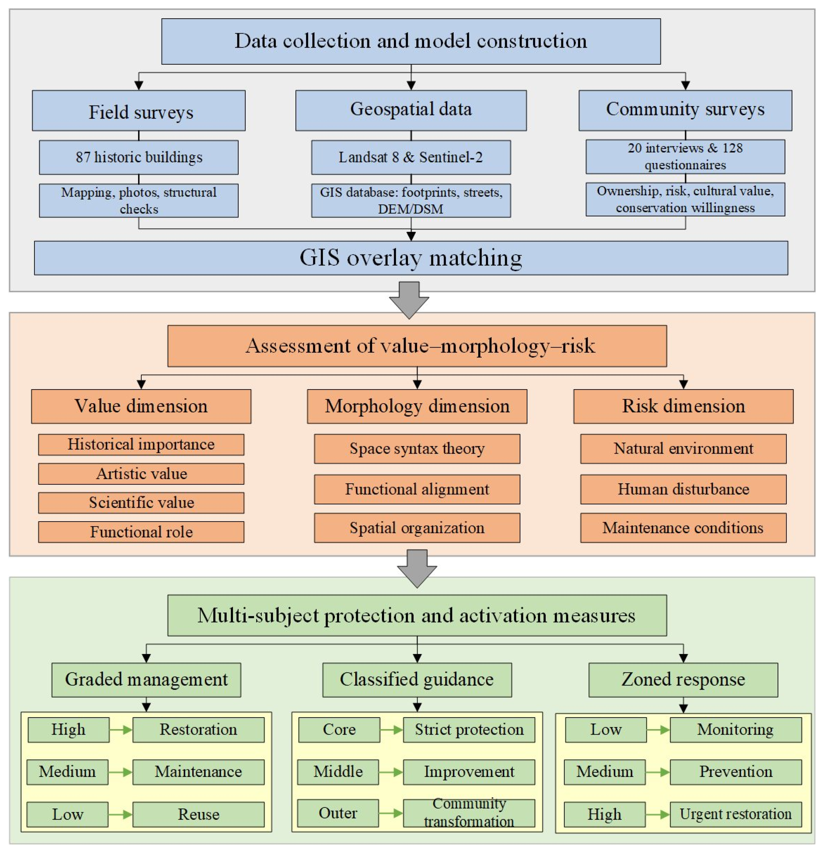
This study addresses the challenge of evaluating and conserving historic buildings not covered by statutory protection systems through the establishment of a technical framework described as “data-driven–multidimensional diagnosis–precise response” (see Figure 2). By integrating multi-source data with spatial analysis methods, the research develops a coupled three-dimensional evaluation system—“value–morphology–risk”—that enables scientific identification, spatial diagnosis, and hierarchical management of conservation targets.
The framework comprises three interrelated dimensions. First, the value dimension quantifies the importance of buildings across four perspectives: historical, artistic, scientific, and functional. Second, the morphology dimension, grounded in space syntax theory, examines the spatial organization of building clusters and their alignment with functional patterns, thereby providing a basis for optimizing town functions and supporting sustainable development. Third, the risk dimension incorporates factors such as natural environment, human disturbance, and maintenance conditions to construct a risk-warning model for identifying potential threats. By coupling these dimensions, the framework produces outputs including value distribution maps, spatial form analysis maps, and risk-warning maps. Collectively, these outputs provide precise, visualized, and actionable decision-making support for the conservation and revitalization of historic and cultural towns.

4.2. Assessment of the Value Dimension

In historic building preservation, value assessment is pivotal for determining conservation priorities and selecting appropriate intervention strategies. Unlike single-dimensional evaluations that focus solely on structural safety or physical integrity, the value dimension captures the overall significance of buildings from multiple perspectives, including historical continuity, artistic expression, scientific and technological attributes, and practical functions [50]. This multidimensional perspective not only helps identify building groups with outstanding cultural and social value but also provides a robust scientific basis for developing differentiated preservation strategies and adaptive reuse models [51]. To this end, this study employs the Analytic Hierarchy Process (AHP) to construct a quantitative assessment model for the value dimension (see Figure 3).

4.2.1. Indicator Selection

To ensure the scientific rigor and operability of the value-dimension indicator system, the selection process followed the principle of “systematic coverage with minimal redundancy,” combining bibliometric analysis with expert validation. The procedure consisted of four steps:
Step 1: Retrieval Strategy and Preliminary Collection
Candidate indicators were identified through a systematic literature search covering the period from January 2005 to May 2025, thereby capturing major research outputs on historic building preservation over the past two decades. The databases consulted included the Web of Science Core Collection, Scopus, ScienceDirect, and China National Knowledge Infrastructure (CNKI), while Google Scholar was employed for cross-validation and manual verification of results (any literature deemed highly relevant to the research topic but not indexed in the mainstream databases was incorporated into the pool for comparison and screening). The searches were restricted to titles, abstracts, and keywords, and employed Boolean logic terms such as (“historic building” OR “cultural heritage” OR “value assessment” OR “evaluation” OR “indicator” OR “index” OR “analytic hierarchy process” OR “AHP”).
Step 2: Establishment of Screening Criteria
To ensure validity and comparability, the following criteria were applied:
(1) Inclusion criteria: (1) Research objects are individual historic buildings or cultural heritage. (2) Involves quantitative or semi-quantitative assessment of the “value” dimension. (3) Clearly proposes or applies an indicator system with methodological support (e.g., AHP, Delphi, fuzzy evaluation). (4) Published in peer-reviewed journals or authoritative academic outlets.
(2) Exclusion criteria:(1) Studies focusing exclusively on structural safety, risk, or environmental impacts in a single dimension. (2) Empirical studies without a systematic indicator framework. (3) Conference abstracts, book chapters, or non-academic publications. (4) Studies targeting urban scales or heritage districts rather than individual buildings.
Step 3: Indicator Extraction and Integration
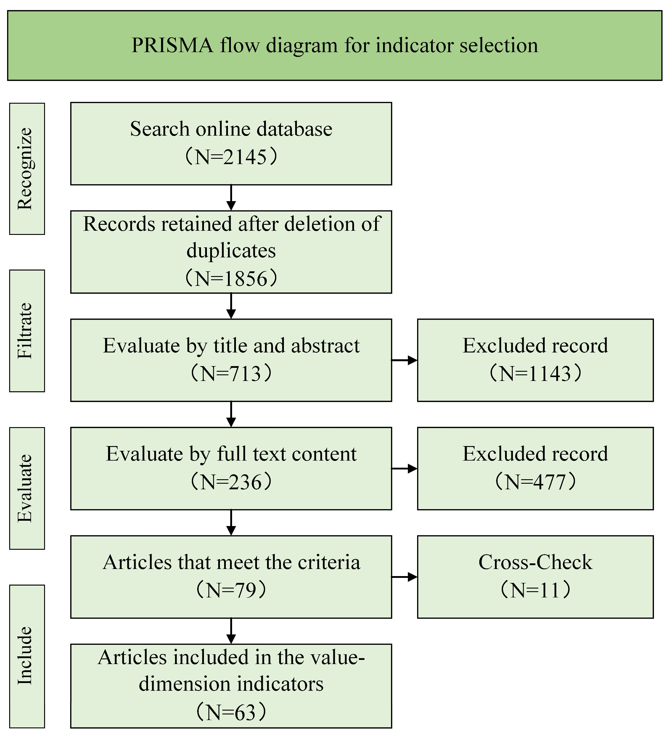
Following the PRISMA transparent screening process (see Figure 4), 68 articles were retained to construct the indicator pool. High-consensus indicators (frequency ≥60%) were preserved through frequency analysis. Low-frequency but practically significant indicators were evaluated through expert consultation and retained when considered critical, while redundant items were eliminated.
Step 4: Expert Consultation and Consistency Testing
To refine the indicator system and ensure methodological rigor, a panel of 12 experts was convened, including architectural heritage scholars, structural engineers, cultural relic managers, and traditional restoration craftsmen. Experts were selected based on the following criteria: at least 10 years of professional or academic experience in architectural heritage conservation, authorship of relevant peer-reviewed publications, or direct participation in major conservation projects.
Following the Delphi method, two rounds of consultation were conducted. In each round, experts rated the relevance and operability of each candidate indicator on a five-point Likert scale. After the second round, responses converged. Convergence was assessed using two criteria: (1) a reduction in the standard deviation of expert ratings between rounds and (2) a Kendall’s coefficient of concordance (W) exceeding the commonly accepted threshold of 0.7, indicating adequate agreement. The finalized framework comprised four dimensions—historical, artistic, scientific, and functional—and 12 indicators (see Table 1).
The final indicators integrated both tangible and intangible attributes, including building age, historical associations, preservation condition, decorative techniques, and structural features, as well as functional adaptability, spatial utilization efficiency, and current usage. Collectively, these provided a comprehensive representation of the cultural, social, and practical value of historic buildings.
To further verify reliability, two researchers independently coded all selected literature. Inter-rater reliability was assessed using both Cohen’s kappa coefficient and percent agreement. Kappa values ranged from 0.82 to 0.90 across major coded variables, with percent agreement exceeding 90%, demonstrating excellent consistency. Discrepancies were resolved through iterative discussion until consensus was achieved. This procedure strengthened the accuracy, objectivity, and robustness of the indicator system, ensuring its scientific credibility and practical applicability.

4.2.2. Weight Determination

To ensure both academic rigor and social acceptability, the Analytic Hierarchy Process (AHP) was employed to determine the weights of the evaluation indicators. A total of 30 evaluators were invited to participate in the pairwise comparison process, including university and research experts, local planning and cultural heritage administrators, grassroots government representatives, and long-term residents. The inclusion of diverse stakeholders ensured that the weighting system achieved a balance between scientific robustness, operability, and social recognition. The weight calculation procedure consisted of three main steps: construction of the judgment matrix, derivation of the weight vector, and consistency testing.
Step 1: Construction of the Judgment Matrix
For each level of indicators, a judgment matrix is constructed using the 1–9 scale method for assignment. Taking the four dimensions at the criterion level—historical value, artistic value, scientific value, and use value—as an example, the judgment matrix A = [aij] is constructed, where aij represents the importance of criterion i relative to criterion j.
A = 1 a 12 a 13 a 14 1 a 12 1 a 23 a 24 1 a 13 1 a 23 1 a 34 1 a 14 1 a 24 1 a 34 1
Step 2: Calculation of the Weight Vector
The relative weight of each criterion was derived through the following process:
(1) Column summation: For each column of the judgment matrix, calculate the sum Sj:
S j = i = 1 n   a i j , j = 1,2 , , n
(2) Normalization: Each element of the judgment matrix was divided by the sum of its column to obtain the normalized matrix B = [bij]:
b i j = a i j S j
(3) Weight vector: The average of each row in the normalized matrix was then calculated to yield the weight vector W = [ w1, w2, …, wm] T:
w i = 1 n j = 1 n   b i j , i = 1,2 , , n
Step 3: Consistency Test
To verify the rationality of the judgment matrix, a consistency test was performed:
(1) Maximum eigenvalue:
λ max = 1 n i = 1 n   ( A W ) i w i
(2) Consistency index (CI):
C I = λ max n n 1
(3) Consistency ratio (CR):
C R = C I R I
where RI refers to the Random Index, which is the average consistency index of randomly generated reciprocal matrices using the 1–9 scale. This adjustment removes the influence of matrix order. According to the standard RI table, the value of a 4th-order matrix is 0.90. If CR < 0.1, the matrix is considered to have acceptable consistency.
Through this process, the weights of each factor were determined, with the criterion-level matrix achieving CR < 0.1, thereby confirming consistency. The detailed results of the indicator weights are presented in Table 2.

4.2.3. Comprehensive Scoring and Graded Expression

Building on weight determination, this study employed the Analytic Hierarchy Process (AHP) to calculate the comprehensive value scores of historic buildings and further categorized them into graded levels to support differentiated conservation and revitalization strategies. The procedure consisted of four stages: indicator scoring, comprehensive score calculation, grade classification, and visualization with application.
Step 1: Indicator Scoring
Each historic building was evaluated across 12 sub-indicators under four main criteria: historical, artistic, scientific, and functional value. The scoring standard was based on the evaluation system in Table 1, using a 0–5 scale, where higher scores represent greater contributions to overall value. Scores were derived from field surveys, archival analysis, and expert assessments, thereby ensuring objectivity, scientific validity, and contextual relevance.
Step 2: Comprehensive Score Calculation
After obtaining indicator weights and individual scores, the comprehensive value of each building was calculated using weighted summation:
V = k = 1 m   w k s k
where V represents the comprehensive value score, wk is the weight of the k-th indicator, sk is the corresponding score, and m is the total number of indicators (12 in this study). This aggregation method quantifies the multidimensional value of each building, providing a single index that reflects its cultural, aesthetic, technological, and functional attributes.
Step 3: Grade Classification
To optimize conservation resource allocation and guide policy formulation, the comprehensive scores were classified using the Jenks natural breaks optimization method, supplemented by expert consensus for boundary refinement. This method minimizes intra-class variance while maximizing inter-class variance, thereby identifying natural thresholds in score distribution. Following iterative expert review, buildings were categorized into four levels:
(1)
Protection Class (V > 2.65): Core buildings of outstanding value, requiring strict protection and systematic restoration.
(2)
Improvement Class (2.65 ≥ V > 2.33): Buildings of relatively high value but with certain structural deterioration, prioritized for repair.
(3)
Retention Class (2.33 ≥ V > 2.19): Buildings of moderate value, maintained through routine upkeep and partial restoration.
(4)
Renovation and transformation Class (V ≤ 2.19): Buildings of limited individual value but important to the integrity of settlement patterns, suitable for selective conservation combined with community development and environmental improvement.
Step 4: Visualization and Application
On the GIS platform, the comprehensive scores were spatialized to generate value distribution maps of historic buildings. These visualizations highlight spatial clustering and distribution patterns across value levels, revealing priority conservation areas as well as gaps in the existing protection system. The graded results provide a scientific basis for governments to formulate differentiated protection measures, allocate conservation funds more effectively, implement targeted repair projects, and promote adaptive reuse strategies for historic buildings.

4.3. Assessment of the Morphology Dimension

The morphology dimension evaluates the spatial organization of building clusters, highlighting the functional logic and vitality mechanisms of historic settlements. Beyond physical form, it reveals intrinsic relationships among street patterns, connectivity, and functional distribution, thereby reflecting structural integrity and long-term sustainability [52]. It identifies core spaces and highly integrated areas while also providing a basis for optimizing business layouts and guiding community revitalization [53].
In this study, space syntax was applied with parameters adapted to the small-scale, winding street networks characteristic of historic towns. Street data were processed in DepthmapX using GIS-derived axis models. The analysis radius was reduced from the urban norm (800–1000 m) to 150 m, consistent with the average street length (120 ± 30 m). Axis segmentation was set at angles >30° to capture dense street patterns. Functional weights distinguished main commercial streets from residential branch lanes, reflecting historical differentiation. Parameter choices were informed by both empirical studies and expert consultation.
The indicator system comprised three metrics. Integration measured the spatial accessibility of public spaces such as ancestral halls and ancient wells [54]. Choice, analyzed at a 50 m radius, traced pedestrian flows and predicted potential physical degradation [44]. Synergy correlated global and local integration (R2 = 0.68) to assess structural consistency [45]. Together, these widely validated indicators captured the interactions among pedestrian flow, spatial structure, and value-carrying capacity.
Compared with conventional connectivity metrics, the selected indicators retained approximately 85% explanatory power while reducing data workload by 40%, thereby enhancing efficiency. Results further revealed a strong correlation between integration and high-value building distribution (r = 0.83, p < 0.01), underscoring spatial accessibility as a key driver of cultural value and functional revitalization. Overall, this quantitative approach effectively captures the unique morphology of historic towns and complements the value and risk dimensions, thereby reinforcing the three-dimensional framework.

4.4. Assessment of the Risk Dimension

The risk dimension assessment focuses on identifying potential threats to buildings and their urgency. Unlike approaches that rely solely on static evaluations of structural safety, this assessment integrates multiple factors—including natural environmental impacts, human-induced disturbances, and maintenance deficiencies—to dynamically reflect building decay processes and vulnerability [55]. It not only facilitates the prioritization of restoration and intervention but also provides a quantitative basis for protection decisions under constrained resources [56].
This study develops a quantitative framework centered on restoration priority ranking, designed to enable dynamic and refined management of historic buildings not included in statutory protection systems. The framework diagnoses building decay through seven key parameters and further incorporates decay acceleration and intervention cost factors to establish a dynamic priority decision model, thereby maximizing conservation benefits under limited resource conditions.
(1) Calculation of the Basic Risk Score
The basic risk score of each historic building was calculated using a weighted cumulative method (Equation (9)). The parameter system was divided into four dimensions: structural safety, material degradation, environmental impact, and functional performance, and the calculation formulas are as follows:
R s = i = 1 7   S i × w i
where Si denotes the score of the i-th parameter (1–5 scale; see classification criteria in Table 3), and wi is the corresponding weight.
(2) Dynamic Priority Index
Building on the basic risk score, this study introduced value attributes, deterioration trends, and cost constraints to construct a dynamic priority index:
P r i o r i t y = R s × V s × 1 + 0.5 α C f
where Vs denotes the comprehensive value score of the building (0–5, see Section 4.2); α represents the deterioration acceleration, measured by annual change indicators such as wall inclination rate or crack propagation rate; and Cf is the cost factor, determined with reference to local repair cost databases and relevant literature, with values set as surface maintenance = 0.6, functional renovation = 1.0, and structural repair = 1.8.
This index integrates cultural value into the risk evaluation while dynamically reflecting both the progression of building deterioration and the financial requirements for repair. It thus overcomes the limitations of traditional static assessments. Based on the calculated priority index, the 87 unlisted historic buildings in Xiangzhu Town were categorized into four risk levels:
(1)
Low risk (≤1.8; 24 buildings): routine monitoring and documentation by community volunteers.
(2)
Medium risk (1.8–2.6; 55 buildings): allocated approximately 45% of the annual budget for preventive maintenance.
(3)
High risk (2.6–3.4; 5 buildings): included in the emergency repair program.
(4)
Structural crisis (>3.4; 3 buildings): subject to urgent reporting and intervention procedures.
In summary, the risk dimension assessment integrates dynamic factors and cost constraints to enable quantitative diagnosis and prioritized ranking of deterioration risks. This approach enhances the applicability of evaluation results for resource allocation and policy implementation, providing strong support for the precise conservation and scientific management of historic buildings.

4.5. Coupled Analysis of Three-Dimensional Assessment Systems

To systematically reveal the comprehensive characteristics of historic buildings across the value, morphology, and risk dimensions, this study combined the Entropy Weight Method (EWM) with the Analytic Hierarchy Process (AHP) for weight determination.
(1) Objective Weight Calculation
Based on the three-dimensional evaluation matrix of 87 historic buildings in Xiangzhu Town, the information entropy of each dimension was calculated as follows:
E j = 1 ln 87 i = 1 87   p i j ln p i j
p i j = x i j i = 1 87   x i j
where xij represents the original score of building i in dimension j. The results showed: value dimension Ev = 0.21, morphology dimension Em = 0.40, and risk dimension Er = 0.61. According to EWM principles, a lower entropy value indicates greater variability and thus a higher weight. Substituting the entropy values into the equation:
W j o b j = 1 E j k = 1 3   1 E k
The objective weights were determined as: value = 0.52, morphology = 0.30, and risk = 0.18.
(2) Subjective Weight Adjustment
To incorporate professional expertise, eight heritage conservation experts with over 15 years of experience participated in two rounds of AHP consultation. In the first round, the judgment matrix (Table 4) was constructed using the 1–9 scale method. In the second round, consistency testing confirmed validity (CR = 0.063 < 0.1).
From this, the subjective weights were derived as: value = 0.648, morphology = 0.230, and risk = 0.122, reflecting expert consensus that the value dimension plays a dominant role in the conservation of historic towns.
(3) Final Weight Synthesis
To balance objectivity with expert judgment, the multiplicative composite method was employed:
W j = W j o b j × W j s u b W j o b j × W j s u b
The final weights were calculated as: value = 0.55, morphology = 0.28, and risk = 0.17. This distribution preserved objectivity while reinforcing the central role of the value dimension in conservation practice.
(4) GIS-Coupled Implementation Process
At the spatial level, GIS was used to integrate the three-dimensional assessment system through the following steps:
Step 1: Data normalization. The range method was applied to eliminate dimensional effects. The risk dimension was inversely processed to ensure that higher risks corresponded to lower normalized scores:
R n o r m = 1 R i min R max R min R
Step 2: Spatial unit reconstruction. The study area was divided into 200 m × 200 m grids, and Zonal Statistics was applied to calculate the mean score of buildings within each grid.
Step 3: Weighted overlay calculation. The composite score for each grid was then calculated as:
C o m p o s i t e = V n o r m × 0.55 + F n o r m × 0.28 + R n o r m × 0.17
This spatial coupling approach provided an integrated and quantitative representation of conservation priorities for historic buildings across the three dimensions of value, morphology, and risk.
(5) Sensitivity Analysis
To validate the robustness of the comprehensive weight allocation, a sensitivity analysis was conducted by introducing ±10% perturbations to the weight values. The results showed that the fluctuation range of the core conservation area was controlled within 6%, and the overall spatial pattern remained stable, with only minor adjustments observed in certain peripheral zones. For example, in the case of the traditional commercial street grid G07, the composite score consistently remained within the range of 0.78–0.80 under weight perturbations, thereby continuing to fall within the core conservation area. These findings indicate that the constructed weighting system demonstrates strong robustness and adaptability, providing reliable support for spatial decision making in historic building conservation.

5. Results and Analysis

5.1. Quantitative Assessment Results of Value Dimensions

5.1.1. Individual Building Scoring

Based on the value evaluation system outlined in Section 4.2, individual buildings in the Xiangzhu Town historical district were systematically assessed across four dimensions: historical, artistic, scientific, and functional value, as illustrated in Figure 5a–l.
Historical Value: As shown in Figure 5a–d, buildings with high historical value—including cultural heritage protection units and traditional-style structures—are predominantly located in the old town core and along the north–south axis, forming a continuous high-value corridor. Approximately 60–70% of these high-value buildings (scored 3–5) are concentrated in the core, while peripheral areas, dominated by post-1980s constructions with lower preservation conditions (scored 1–2), account for about 80% of the total area, reflecting a gradual erosion of historical continuity. It is important to note that the indicators in Figure 5 are assessed independently and therefore do not necessarily exhibit strong correlations. For example, the river-side area in Figure 5c is rated as having high historical relevance not because it contains the oldest structures but due to the concentration of cultural and religious functions associated with a particular historical period. Conversely, some earlier buildings (e.g., from the Ming Dynasty) receive relatively low historical relevance scores either because documentary evidence is insufficient or because their original functions have been completely transformed.
Artistic Value: As depicted in Figure 5e–g, the core area is marked by a dense clustering of traditional architectural styles, rich decorative details, and traditional craftsmanship, fostering a cohesive cultural ambiance. Roughly 65% of buildings in the core exhibit high artistic value (scored 4–5), characterized by Class I and II styles, whereas peripheral regions, featuring modern or mixed forms with diminished artistic integrity (scored 2–3), constitute approximately 75% of the outer zones, aligning closely with the historical value distribution.
Scientific Value: As illustrated in Figure 5h–j, the core region is dominated by low-rise buildings constructed with traditional materials, such as timber and rammed earth, reflecting high authenticity and structural integrity. About 70% of core buildings are traditional structures (scored 4–5), while the periphery, with a higher prevalence of brick-concrete and reinforced-concrete multi-story buildings (scored 1–3), accounts for nearly 85% of the area, resulting in a pronounced spatial gradient of scientific value diminishing from core to periphery.
Functional Value: As presented in Figure 5k–l, the district retains a predominantly residential function, with commercial and public service facilities concentrated along major streets and nodal points, forming localized functional centers. Approximately 55% of core buildings demonstrate high spatial adaptability (scored 4–5), while aging peripheral structures, comprising about 70% of the outer area, show limited adaptability (scored 1–3) due to deterioration and spatial constraints, underscoring the need for targeted renovation and adaptive reuse.
Overall, Figure 5a–l reveal distinct spatial patterns in the distribution of building values across Xiangzhu. Historical and artistic values are highly concentrated in the core, forming a continuous high-value belt along the north–south axis; scientific value declines progressively toward the periphery as modern construction materials and systems replace traditional ones; and functional value exhibits greater diversity and adaptability in peripheral areas. Collectively, these patterns underscore a clear spatial differentiation of “core preservation and peripheral renewal,” providing robust empirical evidence for developing differentiated protection and integrated utilization strategies.

5.1.2. Comprehensive Scoring

Based on the individual building evaluation scores and their respective weights, a quantitative assessment of the overall value of the Xiangzhu Town historical district was conducted. The analysis classified buildings into four categories: preservation, restoration, renovation, and transformation/renewal. This integrated framework moves beyond the limitations of single-dimension interpretations, providing a more holistic understanding of heritage value.
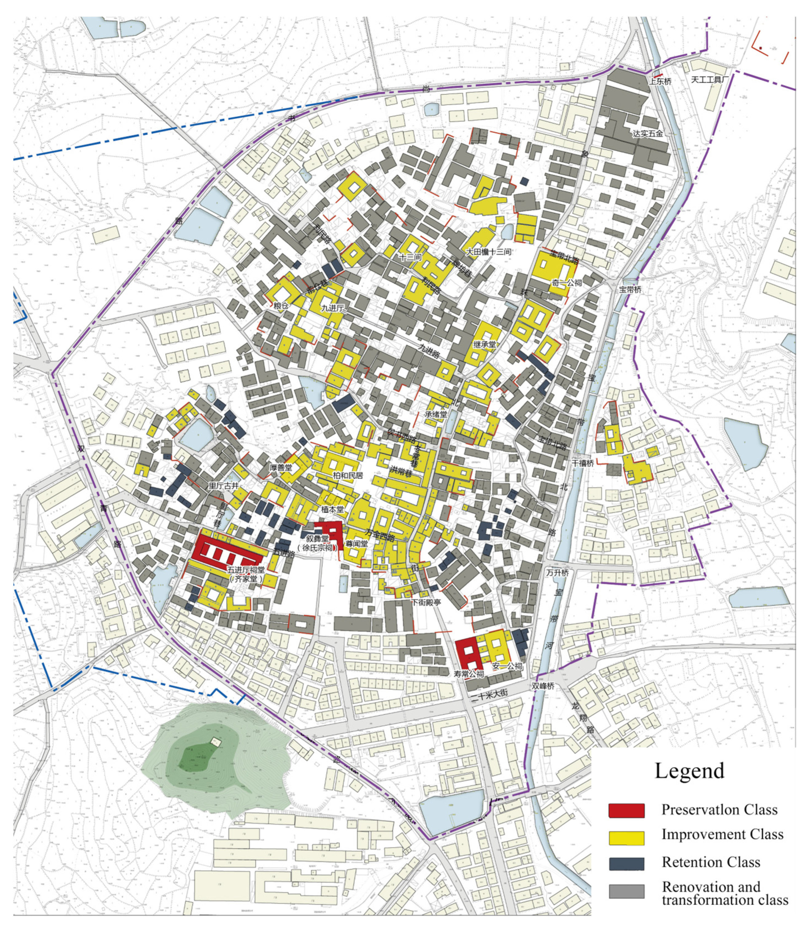
As illustrated in Figure 6, preservation-class buildings, marked in red, constitute approximately 7% of the total area and are predominantly concentrated in the old town core and along traditional north–south axis lanes. These include culturally significant structures such as ancestral halls, guild halls, and designated cultural heritage sites, which serve as critical carriers of historical and cultural continuity. Improvement-class buildings, indicated in yellow and comprising about 30% of the area, are primarily located on the periphery of the core and at intersections of traditional lanes. Despite their high historical and artistic value, these buildings suffer from poor preservation conditions, necessitating urgent restoration efforts. Renovation and transformation-class buildings, shown in gray and accounting for approximately 18%, are situated along secondary lanes and residential zones. With moderate value, they play a supportive role in maintaining the district’s overall spatial pattern. Transformation/renewal-class buildings, depicted in light gray and forming the largest category at over 45%, are concentrated in peripheral areas, consisting mainly of modern residences and functional buildings constructed since the 1980s. These exhibit lower historical, artistic, and scientific value, positioning them as primary targets for future spatial optimization and urban renewal.
The spatial distribution of comprehensive value reveals a distinct “core-concentrated, periphery-declining” gradient. The core district, enriched with preservation- and improvement-class buildings, emerges as the priority zone for conservation and restoration, covering roughly 37% of the total area. In contrast, the periphery, dominated by renovation and transformation/renewal-class buildings (over 63% of the area), is identified as the focus for adaptive reuse and modernization. This classification system provides a scientifically grounded framework for differentiated protection strategies, offering clear spatial guidance for the integrated preservation, restoration, and sustainable development of the Xiangzhu Town historical district.

5.2. Quantitative Assessment Results of Morphology Dimensions

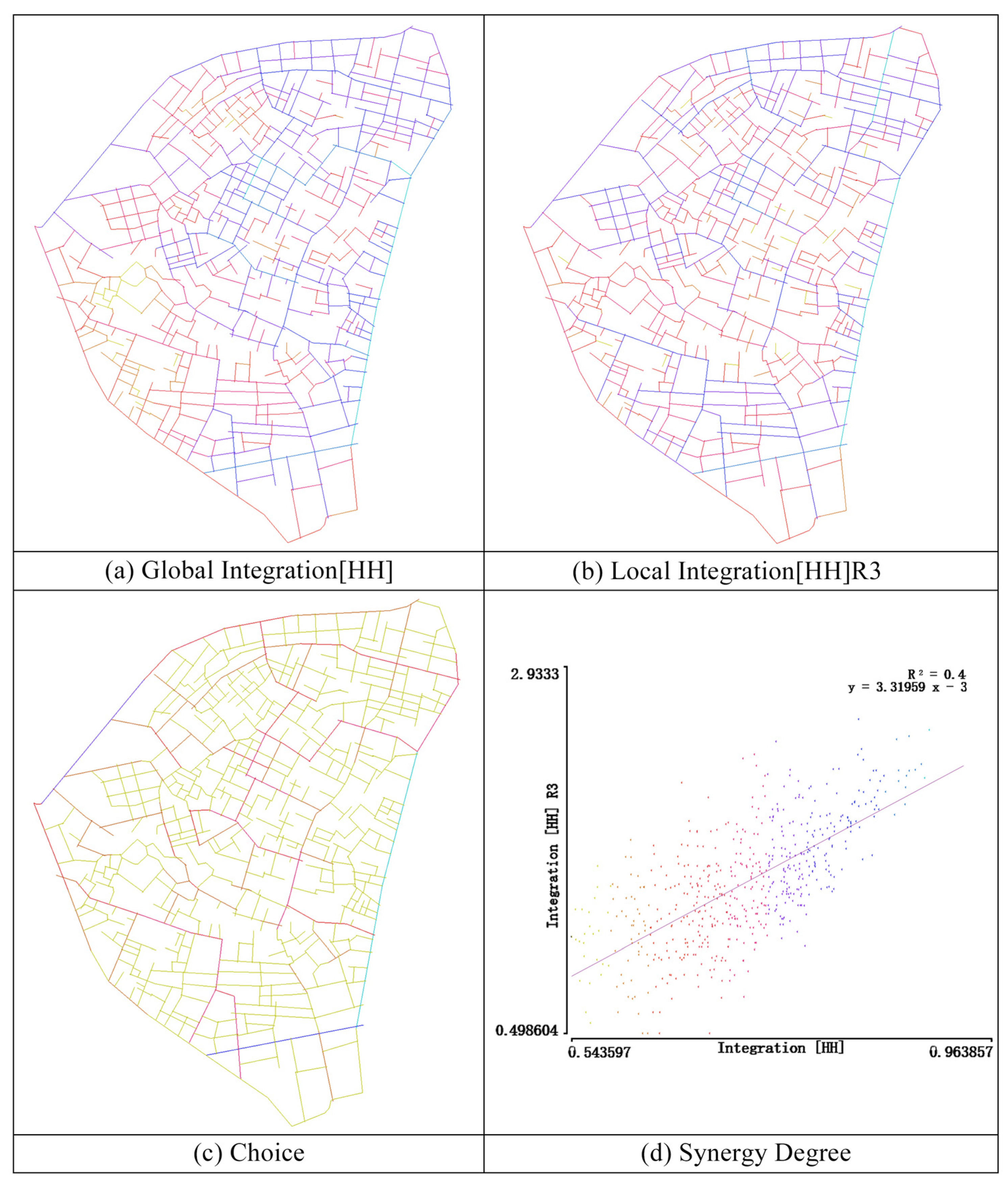
Based on the spatial syntax analysis outlined in Section 4.3, the overall spatial morphology of Xiangzhu Town exhibits a composite structure characterized by “global balance, local heterogeneity, path hierarchy, and moderate synergy,” as detailed in Figure 7 and Table 5.
As illustrated in Figure 7 and quantified in Table 5, the mean global integration value (HH) is 0.727, with a low standard deviation of 0.081, indicating a relatively balanced spatial connectivity across the town. The minimal accessibility disparity between main roads and secondary lanes (Figure 7a) fosters a functionally equitable urban layout. In contrast, the local integration (HH)R3 yields a higher mean of 1.485 and a standard deviation of 0.398, reflecting significant local heterogeneity (Figure 7b). Notable “hotspots” of high local integration are concentrated in the core district and key nodal points, facilitating community interactions and supporting localized service functions. The choice metric, with a low mean of 0.031 but a maximum value of 0.522 (Table 5), reveals substantial variability. Although path substitutability is generally low, several critical corridors exhibit high choice values (Figure 7c), forming the backbone of the town’s transportation network. These corridors serve as primary conduits for pedestrian and vehicular movement, linking key spatial nodes and underscoring the hierarchical and differentiated nature of the street system. Synergy analysis, depicted in the scatterplot (Figure 7d), shows a moderate positive correlation between global integration (HH) and local integration (HH)R3, with a coefficient of determination (R2) of 0.40 and a linear fit equation of (y = 3.31959x − 3). This suggests a partial alignment between global and local spatial characteristics, though not a complete coupling, indicative of a “macro-coherent, micro-diverse” spatial pattern that supports overall continuity while allowing for diverse local functional nodes.
In summary, the spatial morphology of Xiangzhu Town combines global balance with local diversity, embodying a “macro-coherent, micro-diverse” pattern. This reflects the organic spatial structure formed through the long-term evolution of the historical district and provides a robust foundation for subsequent functional optimization and spatial renewal.

5.3. Quantitative Assessment Results of Risk Dimensions

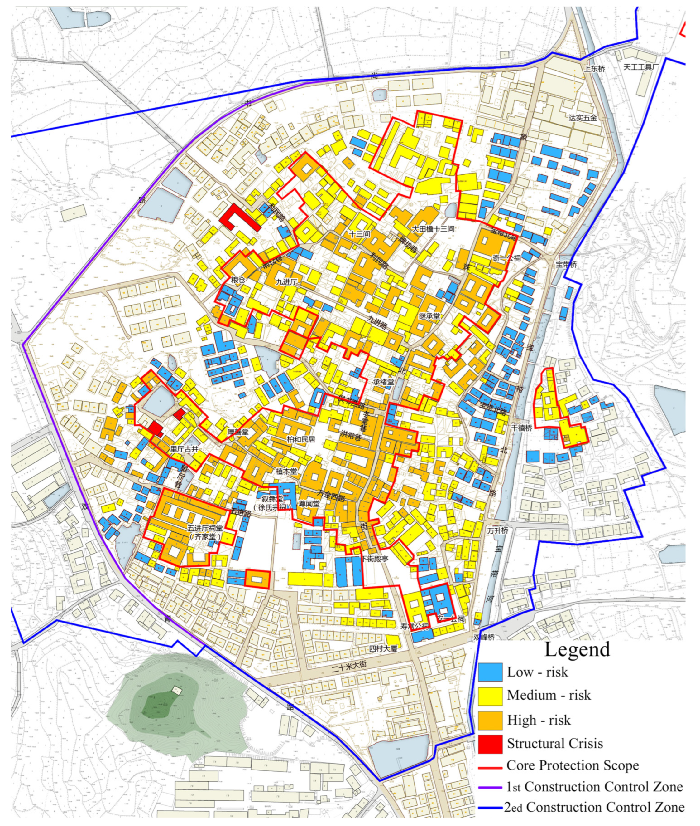
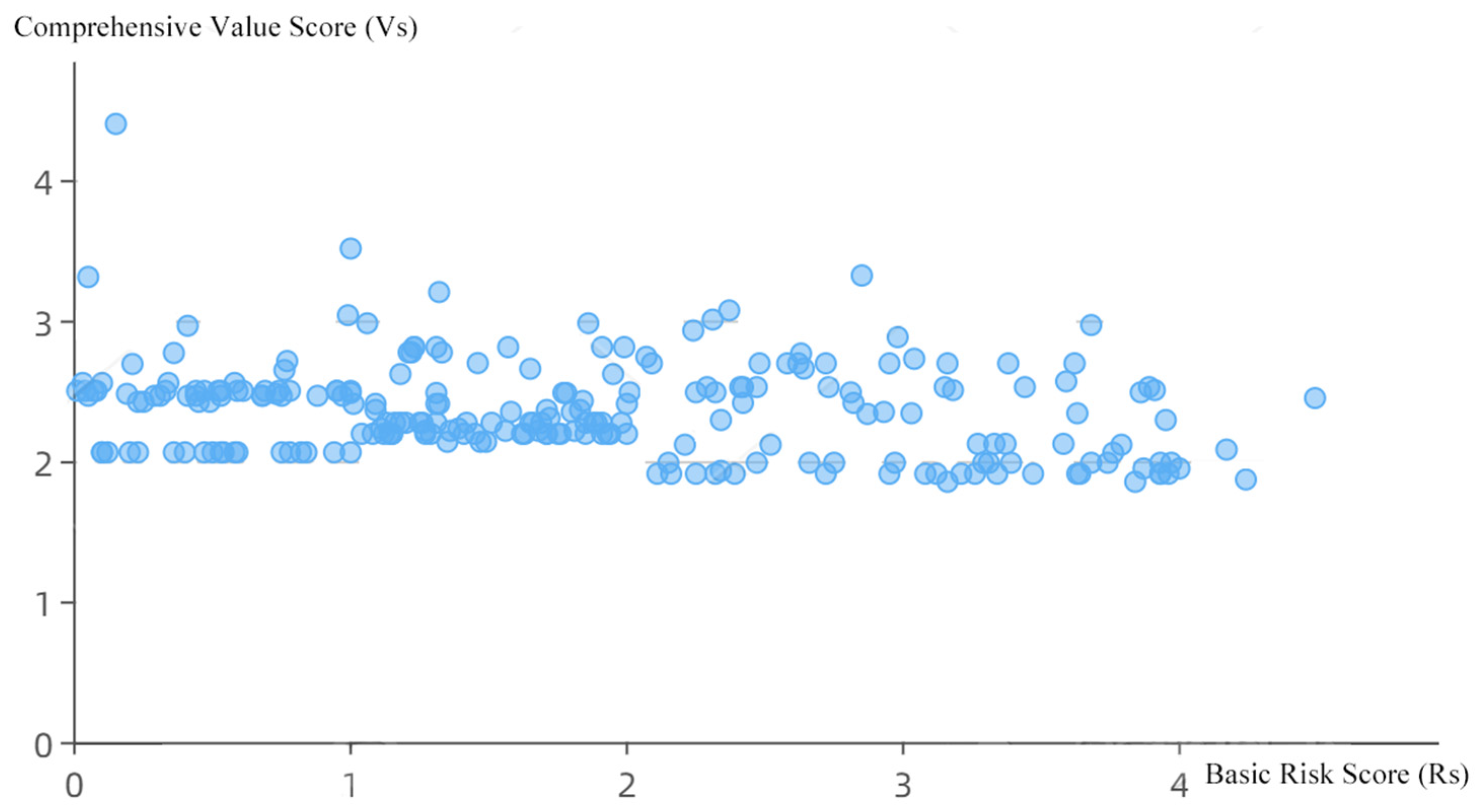
Based on the risk assessment methodology detailed in Section 4.4, a comprehensive analysis of the risk status and restoration priorities for historical buildings in the Xiangzhu Town district was conducted, as illustrated in Figure 8 and Figure 9. The evaluation integrates spatial distribution, basic risk scores (Rs), and comprehensive value scores (Vs).
As shown in Figure 8, the distribution of basic risk scores indicates that 24 buildings are classified as low risk (Rs ≤ 1.8), 55 as medium risk (1.8 < Rs ≤ 2.6), 5 as high risk (2.6 < Rs ≤ 3.42), and 3 as structural crisis level (Rs > 3.42), totaling 87 buildings. High-risk and crisis-level buildings are predominantly concentrated in the central and eastern periphery, where prolonged aging, timber decay, masonry weathering, and inadequate maintenance are prevalent. In contrast, low-risk buildings are primarily located in recently restored or newly constructed zones, reflecting enhanced stability due to modern interventions. The core protection scope and construction control zones delineate areas requiring stringent preservation measures, covering approximately 40% of the district.
The scatterplot in Figure 9 illustrates the relationship between Vs and Rs. Results show that high-risk buildings (Rs > 2.6) span a wide range of value scores (Vs ≈ 1.5–4.0), rather than being confined to low-value categories. This distribution reflects diverse risk sources, including natural aging, functional mismatches, and maintenance neglect. Approximately 70% of buildings exhibit vs. between 2.0 and 3.0, with risk levels peaking around Rs = 2.5–3.0, suggesting a critical intervention threshold.
By integrating value scores (Vs), decay acceleration (α), and cost factors (Cf), the dynamic priority model determines restoration priorities. High-value buildings with rapid deterioration exhibit elevated priority indices. For example, the Qi Yi Ancestral Hall (XZ-43), despite its poor preservation condition, has high historical value (Vs ≈ 4.0) and accelerated decay (α > 0.05), yielding a priority index above 3.0 and necessitating urgent restoration. In contrast, buildings with low value (Vs < 2.0), low risk (Rs < 1.8), and slow decay (α < 0.01) produce priority indices below 1.0, requiring only routine community monitoring and maintenance.
The results highlight that high-risk buildings are not confined to low-value groups, underscoring the multifaceted nature of risk. The dynamic priority model addresses the limitations of static assessments by optimizing resource allocation: prioritizing high-value, high-risk buildings for immediate intervention while applying graded monitoring to low-value, low-risk structures. This approach provides scientific support for graded protection and sustainable renewal strategies, ensuring effective preservation under resource constraints.

5.4. Coupled Analysis of the Three-Dimensional Evaluation System

The entropy weight method and the Analytic Hierarchy Process (AHP) were jointly applied to determine the weights of the three dimensions—value (0.55), morphology (0.28), and risk (0.17). Based on this weighting scheme, a “value–morphology–risk” three-dimensional assessment system was established to evaluate the historical protection value of each building. Reliance on a single dimension can easily produce biased or misleading results. For instance, focusing only on the value dimension may overlook culturally significant buildings that are spatially isolated (poor form) or structurally endangered (high risk). Emphasizing risk alone may inadvertently prioritize low-value but high-risk structures, leading to inefficient allocation of conservation resources. Similarly, focusing exclusively on morphology may promote spatial optimization while neglecting cultural significance, potentially resulting in a loss of authenticity.
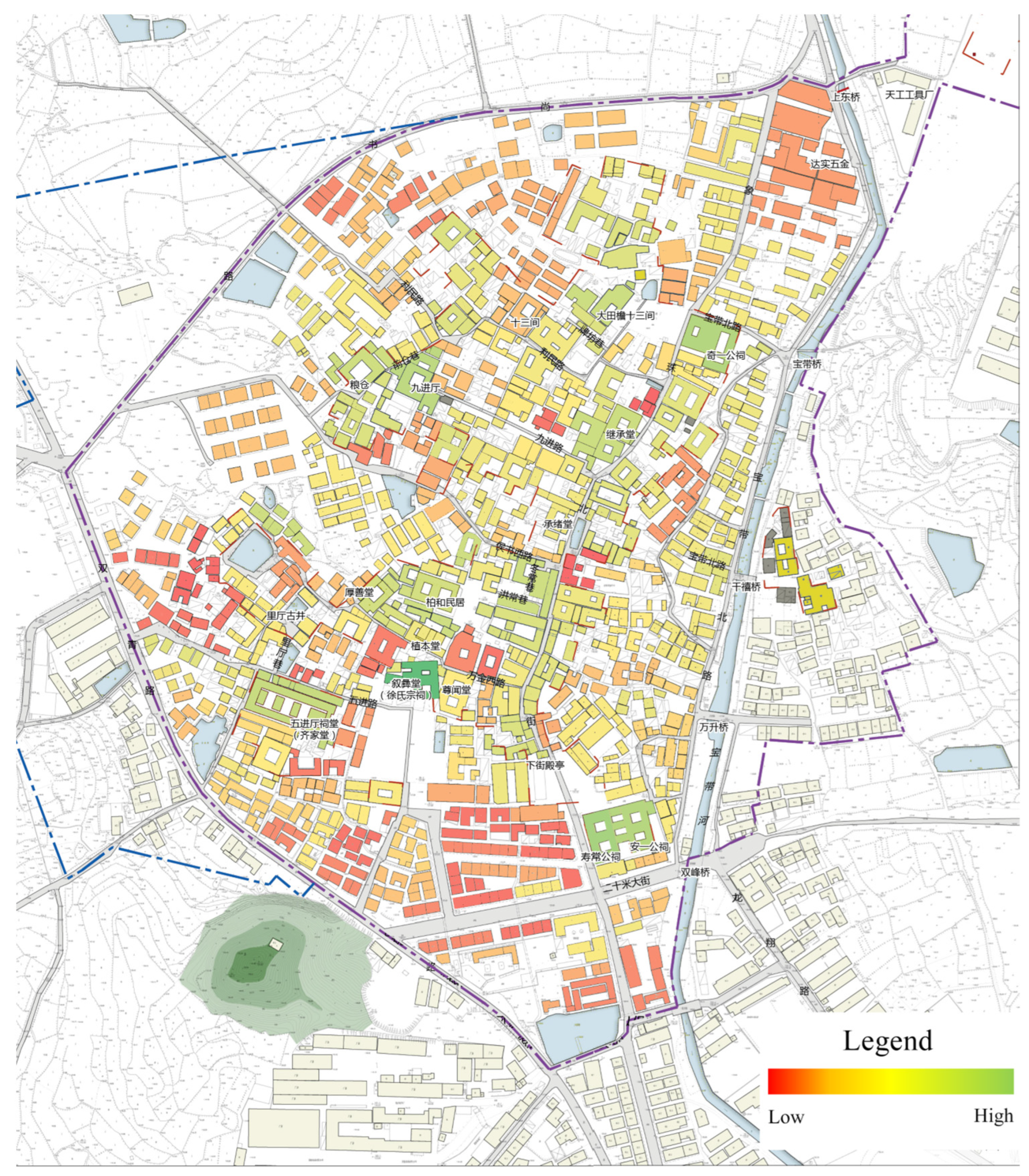
To address these limitations, the integrated framework applies a synergistic logic: value defines cultural essence (core significance), morphology defines spatial compatibility (morphological logic), and risk defines preservation feasibility (practical conditions). Through this approach, buildings characterized by high value, strong compatibility, and low risk are identified as priority targets for conservation. Based on composite scores, buildings were further classified into three tiers: high-value zone (≥0.75), medium-value zone (0.50–0.75), and low-value zone (<0.50), with higher scores indicating greater conservation importance.
As illustrated in Figure 10, high-value zones are primarily concentrated in the core areas along traditional lanes, closely corresponding with the spatial distribution of high-value buildings. These areas not only possess outstanding heritage value but also demonstrate high spatial accessibility and relatively manageable risk levels, making them priority zones for conservation. Medium-value zones are mostly located on the periphery of the core, characterized by moderate scores in value and morphology but elevated risk levels in certain buildings, necessitating targeted monitoring and interventions. Low-value zones are predominantly distributed at the town’s edges, consisting mainly of newly constructed or heavily renovated buildings with lower heritage value, limited spatial integration, and potential risks from functional disruptions. Collectively, these conditions undermine the overall coherence of the town’s historic character. From a spatial coupling perspective, high-value zones exhibit strong synergy across the value, morphology, and risk dimensions, reflecting a relatively stable “space–value–risk” logic shaped by the historical evolution of the core district. By contrast, medium- and low-value zones display shortcomings in one or more dimensions, highlighting significant challenges in safeguarding heritage integrity and spatial governance in peripheral areas amid urbanization pressures.
In summary, the comprehensive evaluation results provide solid empirical support for differentiated protection and renewal strategies in Xiangzhu Town. The proposed “graded management–classified guidance–zoned response” synergistic framework ensures the preservation of heritage value in the core district while directing peripheral areas toward functional optimization and spatial integration. This achieves an organic coupling between heritage protection and sustainable urban development.

5.5. Protection and Adaptive Reuse Measures

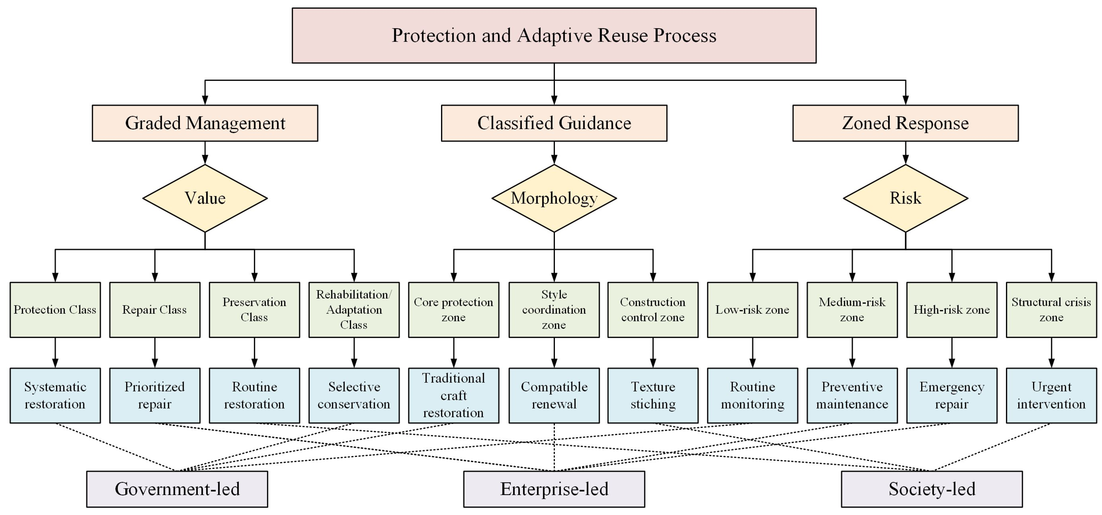
The protection and adaptive reuse of historic buildings are essential not only for safeguarding cultural heritage but also for promoting the sustainable development of historic towns. Effective implementation requires a collaborative mechanism involving governments, enterprises, and local communities to balance authenticity, functionality, and development needs. Drawing on the evaluation results from the value, morphology, and risk dimensions, this study proposes an integrated framework of “graded management–classified guidance–zoned response” (see Figure 11), which links differentiated conservation strategies with multi-stakeholder participation.
(1) Graded Management: The value dimension provides the basis for differentiated conservation pathways. Buildings of outstanding cultural and artistic value should be prioritized for systematic restoration and digital archiving, ensuring authenticity under government leadership. As value decreases, strategies should gradually shift from planned repair and routine maintenance to adaptive reuse and renewal, with enterprises and market forces playing a more active role. Rather than marginalizing low-value buildings, the framework emphasizes their contribution to settlement integrity and encourages innovative revitalization projects that balance cultural continuity with functional transformation. In this way, the value hierarchy not only ranks buildings but also guides resource allocation and diversified reuse models.
(2) Classified Guidance: Morphological features underpin the delineation of management zones. The compact core, characterized by traditional street networks and landmark buildings, requires strict controls and craftsmanship-based restoration but also careful regulation of development intensity and landscape continuity. The coordination zone between core and periphery functions as a transitional buffer, where incremental renewal and functional improvements can be introduced without undermining stylistic harmony. By contrast, the outer construction control zone emphasizes community participation, adaptive reuse, and public-space improvements rather than rigid preservation. This morphological zoning avoids a one-size-fits-all approach, allowing different areas to follow tailored trajectories that reconcile heritage authenticity with socio-economic demands.
(3) Zoned Response: The risk dimension determines the urgency and intensity of interventions. Low-risk buildings can be maintained through routine monitoring and small-scale community-based efforts. Medium-risk assets require coordinated investment and preventive measures, while high-risk or structurally endangered buildings—particularly those of high value—demand immediate restoration under government leadership, often supported by enterprises to share costs and expertise. Risk assessment thus links physical deterioration with management responsibility and resource allocation, ensuring that urgent cases receive timely attention while routine risks are efficiently managed at the grassroots level. This dynamic mechanism reinforces the adaptability of the overall framework, ensuring that conservation remains proactive rather than reactive.
By combining these three dimensions, the framework goes beyond technical classification. It integrates value recognition, spatial logic, and risk control into a coordinated governance system, ensuring that conservation efforts are both differentiated and complementary, thereby balancing heritage authenticity with sustainable revitalization.

6. Conclusions

This study takes Xiangzhu Town, a provincial-level historic and cultural town in Zhejiang Province, as a case to examine the protection and adaptive reuse of historic buildings outside statutory protection. The main findings are as follows:
(1) Spatial differentiation of value. The assessment reveals a clear “core protection–peripheral renewal” pattern. Historical and artistic values cluster in the town core, forming a continuous north–south heritage corridor, while scientific value declines toward the periphery. Functional value demonstrates greater adaptability in the core, whereas older peripheral buildings show limited adaptability. Based on composite scores, buildings are classified into three categories—preservation (7%), restoration (30%), and retention with transformation/renewal (63%)—thereby guiding resource allocation and reuse strategies.
(2) Morphological structure and connectivity. Space syntax analysis indicates a pattern of “macro-level consistency with micro-level diversity.” Global integration is relatively balanced, while localized hotspots emerge in the core. Major corridors serve as transport backbones that sustain a hierarchical street network. Moderate synergy between global and local integration reflects organic spatial evolution, supporting both optimization and renewal efforts.
(3) Risk distribution and prioritization. The risk assessment identifies 24 low-risk, 55 medium-risk, 5 high-risk, and 3 structurally critical buildings. High-risk buildings cluster in the core and eastern periphery due to aging and poor maintenance. A dynamic prioritization model that integrates value, deterioration, and cost proposes differentiated strategies: urgent restoration for high-value/high-risk assets and routine monitoring for low-value/low-risk ones, thereby improving resource efficiency.
(4) Coupling dynamics of value–morphology–risk. Weighted overlay analysis shows that high-value areas (≥0.75) are concentrated along core traditional streets where heritage value, accessibility, and manageable risk converge to form priority protection zones. Medium-value areas (0.50–0.75) require targeted interventions, while low-value peripheral areas (<0.50) face weakened integrity and coherence. High-value areas demonstrate strong synergy across dimensions, whereas peripheral areas are subject to increasing urbanization pressures.
Based on these findings, this study proposes a synergistic strategy of “graded management–classified guidance–zoned response.” Graded management ensures the restoration of high-value buildings while encouraging the adaptive reuse of lower-value ones. Classified guidance delineates core, coordination, and peripheral zones for differentiated treatment. The zoned response introduces a dynamic mechanism based on risk levels. Collectively, this study offers a replicable methodological model for small historic towns and supports the shift in cultural heritage tourism from “rough sightseeing” to “refined experience.” By identifying high-value and low-risk buildings, governments and practitioners can optimize resource allocation and develop culturally rich tourism products, thereby enhancing visitor experience and extending heritage lifecycles. Emphasizing community participation and multi-stakeholder collaboration further provides a reference for linking heritage conservation with tourism revitalization.

Supplementary Materials

The following supporting information can be downloaded at: https://www.mdpi.com/article/10.3390/buildings15193553/s1. Table S1: Questionnaire on Historic and Cultural Towns (Residents/Operators).

Author Contributions

Conceptualization, J.W. and W.W.; data curation, W.W.; formal analysis, J.W.; funding acquisition, W.W.; investigation, J.W. and W.W.; methodology, J.W., C.L. and Z.G.; project administration, W.W.; resources, J.W. and W.W.; software, J.W. and W.W.; supervision, W.W.; validation, J.W., C.L. and Z.G.; visualization, J.W., C.L. and Z.G.; writing—original draft, J.W. and W.W.; writing—review & editing, C.L. and Z.G. All authors have read and agreed to the published version of the manuscript.

Funding

This research was funded by the National Natural Science Foundation of China (Grant No. 51578482) and the Zhejiang University—Zhejiang University Urban Planning & Design Institute Innovation Joint Research Center Project (2025XQZX003).

Data Availability Statement

The original contributions presented in this study are included in the article. Further inquiries can be directed to the corresponding authors.

Conflicts of Interest

The authors declare no conflicts of interest.

References

  1. Wang, Q.; Bing, H.; Wang, S.; Xu, Q. Study on the spatial distribution characteristics and influencing factors of famous historical and cultural towns or villages in Hubei Province, China. Sustainability 2022, 14, 13735. [Google Scholar] [CrossRef]
  2. Yang, L.; Wall, G. Heritage tourism in a historic town in China: Opportunities and challenges. J. China Tour. Res. 2022, 18, 1073–1098. [Google Scholar]
  3. Wu, C.; Yang, M.; Zhang, H.; Yu, Y. Spatial Structure and Evolution of Territorial Function of Rural Areas at Cultural Heritage Sites from the Perspective of Social Space. Land 2023, 12, 1067. [Google Scholar] [CrossRef]
  4. Labadi, S.; Giliberto, F.; Rosetti, I.; Shetabi, L.; Yildirim, E. Heritage and the Sustainable Development Goals: Policy Guidance for Heritage and Development Actors. 2021. Available online: https://kar.kent.ac.uk/id/eprint/89231 (accessed on 27 September 2025).
  5. He, D.; Zhang, Y. Revitalization of Traditional Villages Oriented to SDGs: Identification of Sustainable Livelihoods and Differentiated Management Strategies. Buildings 2025, 15, 1127. [Google Scholar] [CrossRef]
  6. Wang, Y.; Jin, C.; Wang, T.; Xu, D. The Interpretation of Historical Layer Evolution Laws in Historic Districts from the Perspective of the Historic Urban Landscape: A Case Study in Shenyang, China. Land 2025, 14, 1029. [Google Scholar] [CrossRef]
  7. Shi, M.; Huang, X. Reuse of Public Heritage Buildings: Analysis of the Successful Practices and Identification of the Obstacle. Open J. Soc. Sci. 2025, 13, 322–351. [Google Scholar] [CrossRef]
  8. Masciotta, M.G.; Morais, M.J.; Ramos, L.F.; Oliveira, D.V.; Sanchez-Aparicio, L.J.; González-Aguilera, D. A digital-based integrated methodology for the preventive conservation of cultural heritage: The experience of HeritageCare project. Int. J. Archit. Herit. 2021, 15, 844–863. [Google Scholar]
  9. Laohaviraphap, N.; Waroonkun, T. Integrating Artificial Intelligence and the Internet of Things in Cultural Heritage Preservation: A Systematic Review of Risk Management and Environmental Monitoring Strategies. Buildings 2024, 14, 3979. [Google Scholar] [CrossRef]
  10. Riegl, A. Der Moderne Denkmalkultus: Sein Wesen und Seine Entstehung; W. Braumüller: Vienna, Austria, 1903. [Google Scholar]
  11. Jokilehto, J. The context of the Venice Charter (1964). Conserv. Manag. Archaeol. Sites 1998, 2, 229–233. [Google Scholar] [CrossRef]
  12. Boccardi, G. Authenticity in the heritage context: A reflection beyond the Nara document. Hist. Environ. Policy Pract. 2019, 10, 4–18. [Google Scholar]
  13. Rodwell, D. The historic urban landscape and the geography of urban heritage. Hist. Environ. Policy Pract. 2018, 9, 180–206. [Google Scholar]
  14. Hosagrahar, J.; Soule, J.; Girard, L.F.; Potts, A. Cultural heritage, the UN sustainable development goals, and the new urban agenda. BDC Boll. Del Cent. Calza Bini 2016, 16, 37–54. [Google Scholar]
  15. Vecco, M. A definition of cultural heritage: From the tangible to the intangible. J. Cult. Herit. 2010, 11, 321–324. [Google Scholar]
  16. Asteris, P.G.; Chronopoulos, M.P.; Chrysostomou, C.Z.; Varum, H.; Plevris, V.; Kyriakides, N.; Silva, V. Seismic vulnerability assessment of historical masonry structural systems. Eng. Struct. 2014, 62, 118–134. [Google Scholar] [CrossRef]
  17. Vicente, R.; D’Ayala, D.; Ferreira, T.M.; Varum, H.; Costa, A.; da Silva, J.M.; Lagomarsino, S. Seismic vulnerability and risk assessment of historic masonry buildings. In Structural Rehabilitation of Old Buildings; Springer: Berlin/Heidelberg, Germany, 2014; pp. 307–348. [Google Scholar]
  18. Barbieri, G.; Biolzi, L.; Bocciarelli, M.; Fregonese, L.; Frigeri, A. Assessing the seismic vulnerability of a historical building. Eng. Struct. 2013, 57, 523–535. [Google Scholar] [CrossRef]
  19. Sorace, S.; Terenzi, G. Structural assessment of a modern heritage building. Eng. Struct. 2013, 49, 743–755. [Google Scholar] [CrossRef]
  20. Stendebakken, M.O.G.; Grytli, E.R.; Olsson, N.O. Proposed aspects for evaluation of the value of spaces in historic buildings. Procedia Econ. Financ. 2015, 21, 23–31. [Google Scholar] [CrossRef]
  21. Ferretti, V.; Bottero, M.; Mondini, G. Decision making and cultural heritage: An application of the Multi-Attribute Value Theory for the reuse of historical buildings. J. Cult. Herit. 2014, 15, 644–655. [Google Scholar] [CrossRef]
  22. Ferretti, V.; Comino, E. An integrated framework to assess complex cultural and natural heritage systems with Multi-Attribute Value Theory. J. Cult. Herit. 2015, 16, 688–697. [Google Scholar]
  23. Nesticò, A.; Somma, P. Comparative analysis of multi-criteria methods for the enhancement of historical buildings. Sustainability 2019, 11, 4526. [Google Scholar] [CrossRef]
  24. Yau, Y. Multi-criteria decision making for urban built heritage conservation: Application of the analytic hierarchy process. J. Build. Apprais. 2009, 4, 191–205. [Google Scholar] [CrossRef]
  25. Fiore, P.; Sicignano, E.; Donnarumma, G. An AHP-based methodology for the evaluation and choice of integrated interventions on historic buildings. Sustainability 2020, 12, 5795. [Google Scholar] [CrossRef]
  26. Jiang, J.; Zhou, T.; Han, Y.; Ikebe, K. Urban heritage conservation and modern urban development from the perspective of the historic urban landscape approach: A case study of Suzhou. Land 2022, 11, 1251. [Google Scholar] [CrossRef]
  27. Zhou, M.; Chu, S.; Du, X. Safeguarding traditional villages in China: The role and challenges of Rural Heritage preservation. Built Herit. 2019, 3, 81–93. [Google Scholar]
  28. Li, J.; Krishnamurthy, S.; Roders, A.P.; van Wesemael, P. Imagine the Old Town of Lijiang: Contextualising community participation for urban heritage management in China. Habitat Int. 2021, 108, 102321. [Google Scholar] [CrossRef]
  29. Sanagustín-Fons, V.; Stavrou, P.; Moseñe-Fierro, J.A.; Escario Sierra, F.; Castrolla, G.; Rocha, C.; Bazco Nogueras, E. Cultural Heritage Architecture and Climate Adaptation: A Socio-Environmental Analysis of Sustainable Building Techniques. Land 2025, 14, 1022. [Google Scholar] [CrossRef]
  30. Ashrafi, B.; Neugebauer, C.; Kloos, M. A conceptual framework for heritage impact assessment: A review and perspective. Sustainability 2021, 14, 27. [Google Scholar] [CrossRef]
  31. Mohaddes Khorassani, S.; Ferrari, A.M.; Pini, M.; Settembre Blundo, D.; García Muiña, F.E.; García, J.F. Environmental and social impact assessment of cultural heritage restoration and its application to the Uncastillo Fortress. Int. J. Life Cycle Assess. 2019, 24, 1297–1318. [Google Scholar] [CrossRef]
  32. Tsilimantou, E.; Delegou, E.T.; Nikitakos, I.A.; Ioannidis, C.; Moropoulou, A. GIS and BIM as integrated digital environments for modeling and monitoring of historic buildings. Appl. Sci. 2020, 10, 1078. [Google Scholar] [CrossRef]
  33. Sánchez-Aparicio, L.J.; Masciotta, M.G.; García-Alvarez, J.; Ramos, L.F.; Oliveira, D.V.; Martín-Jiménez, J.A.; González-Aguilera, D.; Monteiro, P. Web-GIS approach to preventive conservation of heritage buildings. Autom. Constr. 2020, 118, 103304. [Google Scholar] [CrossRef]
  34. Liu, J.; Willkens, D.; Gentry, R. Developing a Practice-Based Guide to Terrestrial Laser Scanning (TLS) for Heritage Documentation. Heritage 2025, 8, 313. [Google Scholar] [CrossRef]
  35. Liu, J.; Willkens, D.; Gentry, R. A conceptual framework for integrating terrestrial laser scanning (TLS) into the Historic American Buildings Survey (HABS). Architecture 2023, 3, 505–527. [Google Scholar] [CrossRef]
  36. Guerra de Oliveira, S.; Biancardo, S.A.; Tibaut, A. Optimizing H-BIM workflow for interventions on historical building elements. Sustainability 2022, 14, 9703. [Google Scholar] [CrossRef]
  37. Jordan-Palomar, I.; Tzortzopoulos, P.; García-Valldecabres, J.; Pellicer, E. Protocol to manage heritage-building interventions using heritage building information modelling (HBIM). Sustainability 2018, 10, 908. [Google Scholar] [CrossRef]
  38. Wang, H.J.; Zeng, Z.T. A multi-objective decision-making process for reuse selection of historic buildings. Expert Syst. Appl. 2010, 37, 1241–1249. [Google Scholar] [CrossRef]
  39. Bertolin, C.; Loli, A. Sustainable interventions in historic buildings: A developing decision making tool. J. Cult. Herit. 2018, 34, 291–302. [Google Scholar] [CrossRef]
  40. Prieto, A.J.; Macías-Bernal, J.M.; Chávez, M.J.; Alejandre, F.J.; Silva, A. Impact of maintenance, rehabilitation, and other interventions on functionality of heritage buildings. J. Perform. Constr. Facil. 2019, 33, 04019011. [Google Scholar] [CrossRef]
  41. Foster, G. Circular economy strategies for adaptive reuse of cultural heritage buildings to reduce environmental impacts. Resour. Conserv. Recycl. 2020, 152, 104507. [Google Scholar] [CrossRef]
  42. Hillier, B.; Hanson, J. The Social Logic of Space; Cambridge University Press: Cambridge, UK, 1989. [Google Scholar]
  43. Van Nes, A.; Yamu, C. Introduction to Space Syntax in Urban Studies; Springer Nature: Berlin/Heidelberg, Germany, 2021; p. 250. [Google Scholar]
  44. Fu, J.M.; Tang, Y.F.; Zeng, Y.K.; Feng, L.Y.; Wu, Z.G. Sustainable historic districts: Vitality analysis and optimization based on space syntax. Buildings 2025, 15, 657. [Google Scholar] [CrossRef]
  45. Chakraborty, S.; Ji, S. A review of integrating space syntax analysis into heritage impact assessment: A comprehensive framework for sustainable historic urban development. Int. J. Urban Sci. 2025, 29, 123–150. [Google Scholar] [CrossRef]
  46. Wang, X.; Aoki, N. Paradox between neoliberal urban redevelopment, heritage conservation, and community needs: Case study of a historic neighbourhood in Tianjin, China. Cities 2019, 85, 156–169. [Google Scholar] [CrossRef]
  47. Li, K. Traditional Rural Heritage Conservation in China: Policies and Theories. In A Morphological Interpretation of a Northern Chinese Traditional Village: Case Study of Zhangdaicun Village; Springer Nature: Singapore, 2024; pp. 39–114. [Google Scholar]
  48. Veldpaus, L. Historic Urban Landscapes: Framing the Integration of Urban and Heritage Planning in Multilevel Governance. Ph.D. Thesis, Eindhoven University of Technology, Eindhoven, The Netherlands, 2015. [Google Scholar]
  49. Du, C.; Pan, D.; Liu, Q. The Construction of a Protection Network for Traditional Settlements Across Regions: A Case Study of the Chengdu–Chongqing Ancient Post Road Heritage Corridor in China. Land 2025, 14, 327. [Google Scholar] [CrossRef]
  50. Zhang, Y.; Han, Y. Vitality evaluation of historical and cultural districts based on the values dimension: Districts in Beijing City, China. Herit. Sci. 2022, 10, 137. [Google Scholar] [CrossRef]
  51. Rossitti, M.; Oteri, A.M.; Torrieri, F. The social value of built heritage: An interdisciplinary discourse. Built Herit. 2025, 9, 5. [Google Scholar] [CrossRef]
  52. Refaat, A.M. Decoding urban heritage: A multi-dimensional analysis framework applied to Assiut’s historic core. J. Umm Al-Qura Univ. Eng. Archit. 2025, 16, 326–341. [Google Scholar] [CrossRef]
  53. Messaoudi, T.; Véron, P.; Halin, G.; De Luca, L. An ontological model for the reality-based 3D annotation of heritage building conservation state. J. Cult. Herit. 2018, 29, 100–112. [Google Scholar] [CrossRef]
  54. Lyu, Y.; Abd Malek, M.I.; Jaafar, N.H.; Sima, Y.; Han, Z.; Liu, Z. Unveiling the potential of space syntax approach for revitalizing historic urban areas: A case study of Yushan Historic District, China. Front. Archit. Res. 2023, 12, 1144–1156. [Google Scholar] [CrossRef]
  55. Bahtiyar, T.B.; Dişli, G. Risk management and preventive conservation of historic buildings: The case of Karatay Madrasah (Museum). Int. J. Disaster Risk Reduct. 2022, 77, 103079. [Google Scholar] [CrossRef]
  56. Fu, L.; Zhang, Q.; Tang, Y.; Pan, J.; Li, Q. Assessment of urbanization impact on cultural heritage based on a risk-based cumulative impact assessment method. Herit. Sci. 2023, 11, 177. [Google Scholar] [CrossRef]
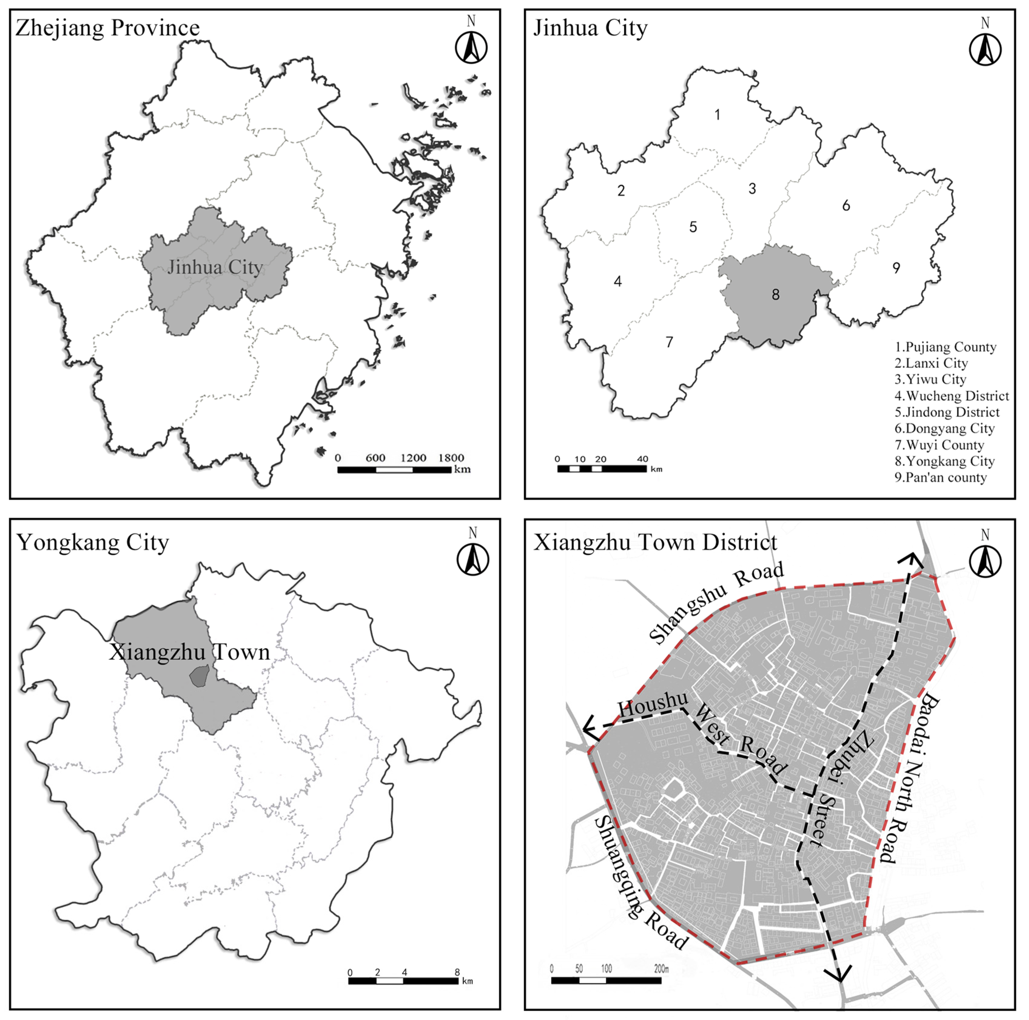
Figure 1. Study area.
Buildings 15 03553 g001
Figure 2. Research framework.
Buildings 15 03553 g002
Figure 3. Quantitative evaluation model based on AHP.
Buildings 15 03553 g003
Figure 4. PRISMA screening flowchart.
Buildings 15 03553 g004
Figure 5. Spatial distribution of individual building scores.
Buildings 15 03553 g005
Figure 6. Comprehensive value assessment of the Xiangzhu town historical district.
Buildings 15 03553 g006
Figure 7. Spatial Syntax Analysis.
Buildings 15 03553 g007
Figure 8. Spatial distribution of building risk levels.
Buildings 15 03553 g008
Figure 9. Relationship between comprehensive value and risk scores.
Buildings 15 03553 g009
Figure 10. Comprehensive evaluation map of Xiangzhu town.
Buildings 15 03553 g010
Figure 11. Protection and adaptive reuse process.
Buildings 15 03553 g011
Table 1. Evaluation Indicator System for Historic Buildings.
Evaluation DimensionEvaluation FactorClassification CriteriaScore
Historical ValueHeritage ClassificationCultural Relic Protection Unit; Cultural Relic Site; Historic Building; Traditional Style Building; Ordinary Building5; 4; 3; 2;1
Building AgeMing Dynasty; Qing Dynasty; Republic of China; Post-Liberation to 1980s; 1980s to Present5; 4; 3; 2; 1
Historical RelevanceHigh (Building fully reflects historical, cultural, or religious value of a specific era); Medium (Building reflects regional characteristics, partially well-preserved); Low (Building does not reflect specific era or regional characteristics)5; 3; 1
Preservation ConditionGood (Structure intact, facade well-preserved); Fair (Structure intact, facade partially damaged); Poor (Structure damaged, facade severely damaged); Very Poor (Structure incomplete, facade completely damaged)5; 3; 1; 0
Artistic ValueArchitectural StyleClass I (No traces of modification, distinct style); Class II (Interior modified, facade mostly intact); Class III (Significant interior modification, facade damaged); Class IV (Significantly different from modern architectural style)5; 4; 3; 2
Architectural DecorationRich (Carvings, paintings, and other decorations well-preserved); Fair (Some decorations preserved); Sparse (Decorations severely missing or damaged)5; 3; 1
Construction TechniqueTraditional Craftsmanship (Mortise-and-tenon, brick carving, wood carving, etc., well-preserved); Modern Craftsmanship (Partially uses modern techniques); Mixed Craftsmanship (Combination of traditional and modern techniques)5; 3; 1
Scientific ValueBuilding StructureTraditional Rammed Earth Structure; Traditional Timber Structure; Modern Structure (Reinforced Concrete); Mixed Structure (Combination of traditional and modern structures)5;5; 3; 1
Building HeightLow-rise (1–3 floors); Mid-rise (4–6 floors); High-rise (>6 floors)5; 3; 1
Building MaterialsTraditional Materials (Timber, brick, rammed earth, etc.); Modern Materials (Concrete, steel, etc.); Mixed Materials (Combination of traditional and modern materials)5; 3; 1
Functional ValueFunctional UtilityResidential; Commercial; Public (e.g., cultural display, community activities); Industrial5; 4; 3; 1
Spatial AdaptabilityHigh (Flexible spatial layout, suitable for multiple functions); Medium (Relatively fixed layout, some functions adjustable); Low (Fixed layout, difficult to adapt for other functions)5; 3; 1
Table 2. Indicator weights.
Criteria LayerWeight CoefficientEvaluation FactorSub-Factor WeightComprehensive Weight
Historical Value0.5191Heritage Classification0.24620.1280
Building Age0.29570.1538
Historical Relevance0.22900.1191
Preservation Condition0.22900.1191
Artistic Value0.2009Architectural Style0.34290.0689
Architectural Decoration0.36360.0731
Construction Technique0.29350.0590
Scientific Value0.0788Building Structure0.34290.0270
Building Height0.36360.0286
Building Materials0.29350.0231
Functional Value0.2009Functional Utility0.50000.1005
Spatial Adaptability0.50000.1005
Table 3. Key parameters and grading criteria.
Parameter1 Point (Low Risk)3 Points (Medium Risk)5 Points (High Risk)Threshold Determination BasisQuantification Method
Wall Tilt Ratio<0.5%1.0–1.5%>2.0%Based on Standard for Appraisal of Dangerous Buildings (GB 50292-2015), stability control requirements for timber-masonry and brick-concrete structures: <0.5% is generally considered safe; >2% significantly impacts stability.Total station + crack monitoring device
Timber Component Decay Ratio<10%20–30%>50%Derived from Technical Specification for Ancient Building Restoration and timber durability studies: <10% indicates normal aging; 20–30% affects load-bearing capacity; >50% signifies critical deterioration.Endoscope + insect hole grid counting
Foundation Settlement Differential<15 mm25–30 mm>40 mmBased on Code for Design of Building Foundation (GB 50007-2011): settlement differential >30–40 mm may cause structural cracks; <15 mm is typically acceptable.Leveling instrument with triangulation elevation method
Masonry Weathering Depth<4 mm6–8 mm>12 mmDerived from stone durability studies and heritage conservation cases: <4 mm indicates mild weathering; 6–8 mm suggests moderate damage; >12 mm typically leads to surface spalling and reduced load-bearing capacity.Needle penetration test (four-directional measurement)
Roof Leakage RateNo water stains≤3 localized leaksLarge-scale wettingBased on field inspection experience: no water stains indicate minimal risk; >3 localized leaks suggest localized systemic damage; large-scale wetting indicates near-total loss of roof functionality.Infrared thermal imaging + manual inspection
Floor Deflection (δ/L)<1/4001/300–1/250>1/200Based on Code for Design of Timber Structures: normal usage limit is approximately 1/400; δ/L >1/200 indicates significant deficiencies in load-bearing and usability performance.1 kN load + dial indicator displacement measurement
Door/Window Obstruction Rate<20%40–50%>60%Derived from usability surveys: <20% obstruction indicates normal aging; 40–50% significantly impacts usability; >60% suggests structural or deformation issues causing widespread operational hindrance.Random sampling of 10 doors/windows + resistance testing
Table 4. Judgment Matrix for Evaluation Criteria.
ValueMorphologyRisk
Value135
Morphology1/312
Risk1/51/21
Table 5. Spatial Syntax Analysis Data Results.
Global Integration [HH]Local Integration [HH]R3Choice
Mean0.7271.4850.031
Minimum0.5440.4990
Maximum0.9642.9330.522
Standard Deviation0.0810.3980.058
Disclaimer/Publisher’s Note: The statements, opinions and data contained in all publications are solely those of the individual author(s) and contributor(s) and not of MDPI and/or the editor(s). MDPI and/or the editor(s) disclaim responsibility for any injury to people or property resulting from any ideas, methods, instructions or products referred to in the content.