Article

Health Assessment of Historic Blocks Based on Multi-Source Data: A Case Study of the Blocks Along Ciqi Street, Yongqing Street, and Yongtai Street in Shedian Town, Nanyang City, China

School of Architecture, Zhengzhou University, Zhengzhou 450001, China
*
Author to whom correspondence should be addressed.
Buildings 2025, 15(19), 3502; https://doi.org/10.3390/buildings15193502
Submission received: 11 August 2025 / Revised: 11 September 2025 / Accepted: 23 September 2025 / Published: 28 September 2025

Abstract

In the context of building healthy cities and enhancing the quality of historic blocks, assessing their health levels is of critical importance. However, research on health assessments of historic blocks remains limited, and existing evaluation frameworks often struggle to balance comprehensiveness with contextual specificity. Using the blocks along Ciqi Street, Yongqing Street, and Yongtai Street in Shedian Town, Nanyang City, as a case study, this study develops a health assessment system comprising five primary indicators, including block safety, block comfort, block ecological nature, block convenience, and block cultural nature, along with eleven secondary indicators and seventeen tertiary indicators. Based on SHP data, street view imagery, meteorological data, DSM data, and other relevant datasets and employing multiple analytical methods, including ArcGIS, semantic segmentation, and Grasshopper, a health assessment of the target blocks is conducted. The results indicate that the target blocks face significant safety issues, with health challenges primarily associated with their internal built environments. Finally, the study proposes three measures for quality improvement, providing references for related research and the renewal of historic blocks.

1. Introduction

Historic blocks result from the accumulation of multiple factors—cultural, economic, and social—across different historical periods. They constitute valuable urban assets and cultural heritage, while also serving as living spaces for local residents [1]. Since the implementation of China’s Reform and Opening-up policy, rapid and often unchecked urbanization has neglected the need for high-quality urban development, giving rise to a growing array of challenges within established urban areas, including historic blocks. These challenges include poor living conditions, lack of public spaces, environmental pollution, and traffic congestion. Since the 18th National Congress of the Communist Party of China, the central government has elevated the concept of “Healthy China” to a national strategy. In October 2016, the Central Committee of the Communist Party of China and the State Council released the “Healthy China 2030” blueprint, which proposed that the development of healthy cities and towns be a key component in advancing the construction of a Healthy China. In 2019, the National Health Commission published the Healthy China Initiative 2019–2030 emphasizing the need to improve health levels within cities and communities [2,3]. The 14th Five-Year Plan, released in 2021, also underscored the importance of comprehensively advancing the Healthy China initiative. Urban blocks and towns are fundamental units of cities, with historic blocks serving as key carriers for the transmission of urban history and culture. They also play a critical role in the regeneration of existing urban areas. Consequently, creating healthy historic blocks is essential not only for the development of healthy towns and cities but also for the preservation of traditional culture and the realization of “Healthy China.” Conducting health assessments in historic blocks enables the evaluation of their health status, the identification of health challenges, and the provision of guidance for addressing these issues through urban planning, urban design, and micro-regeneration strategies.
In the fields of architecture and urban planning, health assessments typically focus on urban areas and communities of various scales [4,5], urban infrastructure such as city utilities and bridges [6,7,8], as well as urban ecosystems represented by forests, rivers, and lakes [9,10,11]. These assessments are often based on multi-source data and comprehensive indicator systems. For instance, in 2021, Gao Wei developed an evaluation system for aging residential communities, covering land use, transportation, spatial facilities, and a composite index [4]. In 2024, Zhang Yichi developed a street-space health evaluation index system, which includes six dimensions, human perception, degree of land use mix, density, travel distance, destination accessibility, and design, using the Dingwangtai area of Changsha as study case [12].
In recent years, health assessment research has expanded beyond various urban spaces to include the built environments of rural areas. Moreover, recent studies have increasingly focused on vulnerable groups in society, such as the elderly and children. For example, in 2024, Jia Fan proposed a child-friendly public space evaluation framework for rural areas in China, emphasizing safety, accessibility, comfort, and multifunctionality [13]. In the same year, Li Yuhua addressed the health needs of older adults by developing a multidimensional evaluation index system for the suitability of urban square spaces, incorporating physiological, psychological, and social health perspectives [14]. Additionally, Huang Jiaxin and colleagues employed the fuzzy Delphi method and the analytic hierarchy process to establish an evaluation system for assessing the restorative potential of public open spaces in urban communities with high levels of aging [15].
However, research on health assessments for historic blocks remains limited, and existing studies typically focus on the scale of urban planning and design rather than extending to more granular units such as individual buildings within historic blocks [16,17]. Moreover, current research tends to emphasize the built and social elements of the blocks, with limited attention to natural and ecological factors. Due to differences in research focus and methodology, existing studies often fail to comprehensively address the diverse health issues faced by historic blocks.
At the international level, the World Health Organization (WHO) defines health as encompassing physical, mental, and social dimensions. In addition, the WHO’s Integrating Health in Urban and Territorial Planning: A Sourcebook provides a comprehensive framework for healthy urban spaces, incorporating indicators such as environmental exposure, social equity, transport accessibility, public services, and green space distribution [18]. Building on the WHO’s 11 Healthy City Goals, Abbas Ziafati Bafarasat developed a set of 99 urban health indicators by refining existing metrics and introducing new indicators specifically tailored to these goals [19].
Other studies have focused on specific types of urban spaces or particular influencing factors to examine their impacts on human health. For example, Cardinali employed the AID-PRIGSHARE tool to construct an indicator system encompassing seven measures—including accessible greenness, accessible green spaces, green space corridors, and mixed uses of green spaces—to investigate the effects of urban greenery on social cohesion and residents’ mental health. From an urban policy perspective [20]. Melanie Lowe developed a ten-indicator framework—including city planning, distance to public transport, distribution of employment, and air pollution—to assess whether urban planning policies across 25 cities in 19 countries support healthy and sustainable urban development [21]. Rueda Samuel examined the influence of urban parks on community health by analyzing park quality, accessibility, and usage patterns [22]. Wang Siqin and colleagues integrated the Heat Exposure Index, Heat Hazard Index, and Heat Vulnerability Index to propose the Heat Health Risk Index (HHRI), a comprehensive metric applied to assess urban heat-related health risks in Australian cities [23].
In addition, health impact assessments, which share similar methods with health assessments, utilize composite indicator systems to evaluate the potential effects of a specific plan or policy on public health. For example, Ge Yifu developed a health impact assessment system for urban planning at both the city and district levels [24]. Wang Lan created a theoretical framework for health impact assessments in urban planning [25]. Zhang Yalan and colleagues, through studying health impact assessment practices in Atlanta, provided insights for domestic planning evaluations [26]. These assessments can therefore inform the construction and analytical methods of health assessment systems.
From a methodological perspective, with the advancement of computational technologies and open-source tools and platforms [27], the efficiency of data acquisition and analysis have been significantly enhanced. Street view image (SVI) [28,29], regional climate data, and similar datasets are now readily accessible through open-source websites and have been widely applied in various studies. Various analytical tools have also seen widespread application in evaluative studies, such as semantic segmentation [30], GIS analysis [31], Grasshopper simulation, etc.
To identify the health issues present within the built environment of the target blocks and to characterize their spatial distribution, thereby providing a reference for future blocks renewal efforts, this study establishes an evaluation framework through field investigation and a systematic synthesis of existing research and employs multisource data and various analytical methods to conduct a health assessment in the target blocks.

2. Materials and Methods

2.1. Overview of the Study Area

Shedian Town originated during the Han Dynasty and flourished during the Ming and Qing Dynasties due to its prosperous water transport system. However, it gradually declined in modern times as a result of wars and hydrological changes. After the founding of the People’s Republic of China, Shedian entered a period of modern expansion, during which its urban scale steadily increased and, in 1965, it was incorporated into Sheqi County. This phase, however, largely neglected the preservation and revitalization of traditional spatial patterns and cultural heritage. Over the past decade, efforts to safeguard Shedian’s historic urban fabric, architectural heritage, and cultural identity have intensified through the implementation of formal conservation plans. These initiatives have contributed to the preliminary revival of the town’s traditional character. Nevertheless, the built environment remains complex, shaped by a turbulent and dynamic developmental trajectory, and continues to present significant health-related challenges.
This study selects seven blocks along Ciqi Street, Yongqing Street, and Yongtai Street as the primary research area, which span approximately 515 m from north to south and 400 m from east to west, covering a total area of 18 hectares. The target blocks, as the only area within Shedian Town that has preserved a substantial number of historic buildings, exhibits the complex spatial environment, giving rise to a range of health-related challenges, such as insufficient fire evacuation capacity, poor sanitation and unfavorable ecological environment; therefore, it is essential to conduct a comprehensive and systematic health assessment to these blocks.
For the purposes of subsequent evaluation and analysis, the study designates the blocks from north to south and west to east with alphabetical labels A through G (Figure 1).

2.2. Research Framework

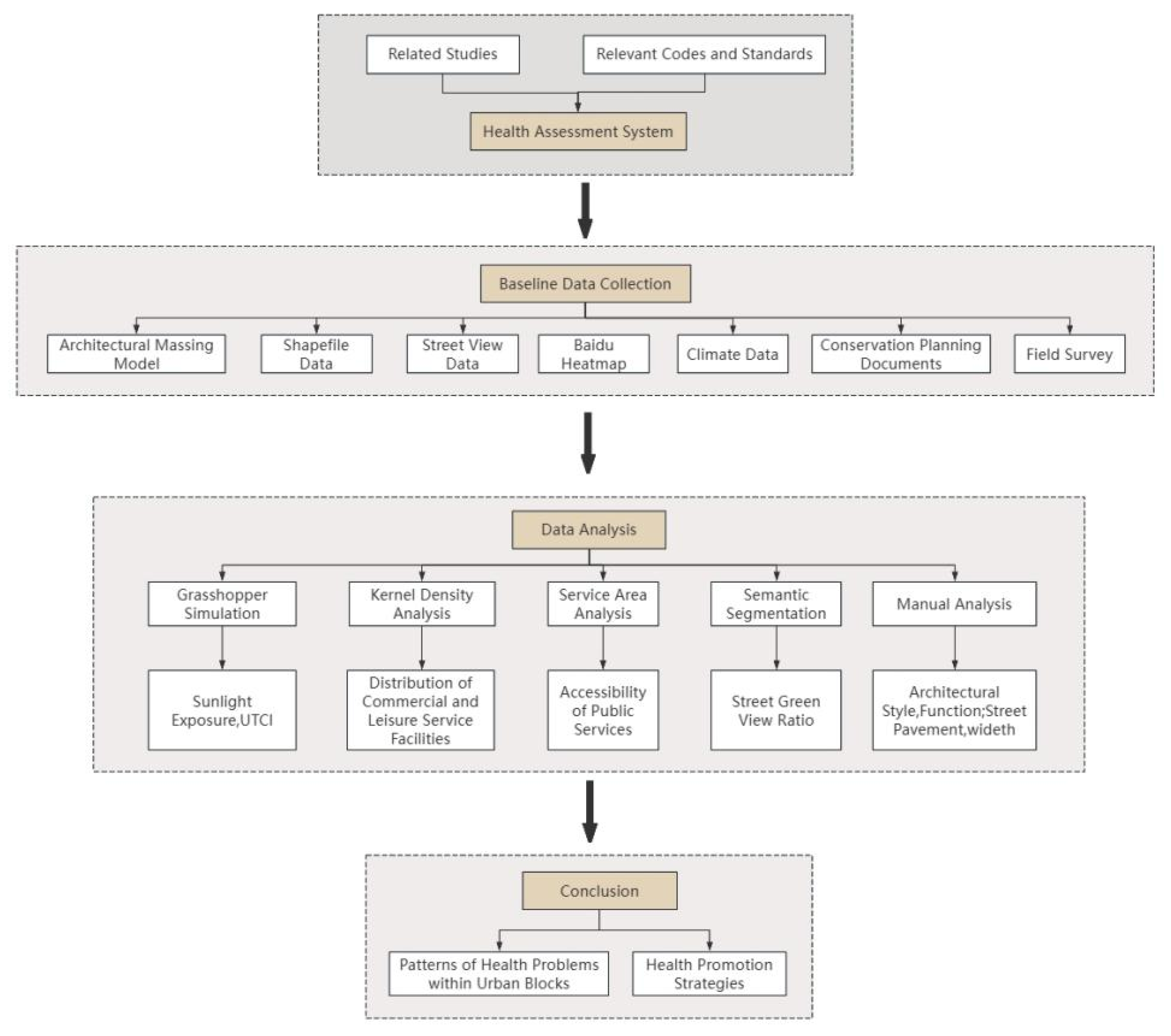
Firstly, this study conducted a field investigation across the target blocks and reviewed relevant literature on healthy cities and communities. The field investigation included photographing the built environment to obtain direct visual records and interviewing local residents to understand their living conditions and needs. In addition, planning documents of Shedian Town from different historical periods were obtained from the local government. The reviewed literature encompassed conceptual frameworks, evaluation methodologies, comprehensive reviews, and governmental guidelines. Based on these efforts, the study identified the major health challenges currently faced by the target neighborhood and developed a corresponding health assessment indicator system comprising five primary indicators, eleven secondary indicators, and seventeen tertiary indicators.
Secondly, According to the evaluation indicator system, the study acquired the necessary data through a combination of field surveys and open-source resources.
Finally, based on multi-source data and various research methodologies, a health assessment is conducted to provide a basis for the subsequent renovation and preservation of the target blocks and to offer insights for future research on health assessments of historic blocks (Figure 2).

2.3. Construction of the Evaluation Indicator System

The field investigation revealed that the target blocks faces multiple challenges, including overcrowded living conditions, generally poor building quality, and potential fire safety hazards. In addition, this study reviewed existing standards, guidelines, reviews, and evaluation frameworks related to healthy cities and communities. The analysis indicated that current assessment systems are either relatively comprehensive but insufficiently targeted, or unsuitable for the target blocks due to differences in research focus and study scope. For example, the Assessment Standard for Healthy Communities recommends evaluating communities across six dimensions—air, water, comfort, fitness, culture, and services [32]. While this framework is highly comprehensive, it lacks specificity for the target blocks. Similarly, Li Jianhua evaluated the historic Wudadao neighborhood in Tianjin from six perspectives—spatial layout, transportation, environment, culture, industry, and management. Although thorough, this framework emphasizes the built environment and social factors while overlooking natural environmental aspects [17]. In another case, Jia Fan proposed an evaluation framework focusing on safety, accessibility, comfort, and multifunctionality, which provides relatively comprehensive coverage of the conditions and challenges faced by children in underdeveloped regions. This framework is specifically tailored to children’s health and is therefore not fully applicable to historic blocks [13].
Building on the above work, this study proposes an evaluation indicator system comprising 5 primary indicators—block safety, block comfort, block ecological nature, block convenience, and block cultural nature—together with 11 secondary indicators and 17 tertiary indicators. Safety is the fundamental prerequisite for achieving health, while a comfortable block environment, built upon this foundation, is essential for fostering both physical and mental well-being. Beyond the target blocks, ecological conditions and public facilities exert broader influences on residents’ quality of life, with social ecology and infrastructure further reflecting community health at the societal level. Historic blocks also embody the cultural heritage and identity of a city; safeguarding traditional culture and urban character not only enhances spatial quality but also strengthens residents’ sense of belonging. The inclusion of cultural value as an indicator highlights the distinctive attributes that differentiate historic blocks from ordinary urban areas. Each indicator is divided into five levels, and the assessment thresholds for these indicators were established based on relevant standards, prior research, existing literature, and on-site investigations of the target blocks. To align with the five-level classification scheme, this study adjusted some certain evaluation thresholds originally proposed in the previous literature. For example, the Assessment standard for green eco-district stipulates that public open spaces should be incorporated within urban districts, with each individual space covering no less than 300 m2. The standard also stipulates that the proportion of the urban area within a 500 m service radius of such spaces be evaluated on a ten-point scale: 40% coverage corresponds to 5 points, 50% to 7 points, and 60% to the maximum score of 10 points. Building upon this provision, an evaluative threshold system was developed for the indicator “500 m Service Radius of Public Spaces (≥300 m2)” within the assessment framework.
The detailed components of the assessment framework are presented in Table 1 and Table 2.

2.4. Data Sources

Data for this study were collected using three primary methods: field surveys, drone mapping, and open-source data acquisition. A DJI Phantom 4 RTK drone captured oblique aerial imagery of both the target blocks and the entire town. The images were processed with DJI Terra software to generate models in OSGB format. From the OSGB data, DSM, DOM, and DEM datasets for the blocks were derived using OSGB Lab software and ArcGIS 10.8.
Open-source data websites and tools were employed to gather road and building SHP data, points of interest (POI) data for various public facilities, and climate data for Nanyang City. The missing building and road vector data in the open-source datasets were manually supplemented and completed using the OSGB model and EPS 2019, with additional information on the number of building floors. This process resulted in the creation of a current topographic map of the target blocks.
Heatmap from Baidu Maps was used to extract crowd activity data within the target blocks. Using the Baidu Maps street view feature, street-level images of the streets surrounding target blocks were captured at 20 m intervals, since Baidu street view data does not cover internal roads within the target blocks, additional street-level images of the internal roads were obtained through field photography. The location of these photos was determined using the Two Steps Walk app, one photograph was captured in each of the four cardinal directions—front, back, left, and right at each sampling location.
For 3D modeling of the target blocks, AutoCAD 2018 and Rhino 7 were used. In the case of mixed-slope roofs (gable and flat), the average height of the roof was taken as the model’s reference value [38].

2.5. Methodology of Analysis

Based on references to relevant content in the Historical and Cultural Heritage Protection Plan for Shedian Town, Sheqi County, Nanyang City (2016–2030) (hereafter referred to as the Plan) and combined with field research, an assessment was conducted on several indicators, including building quality, traditional streetscape, and the revitalization and adaptive reuse of cultural heritage.
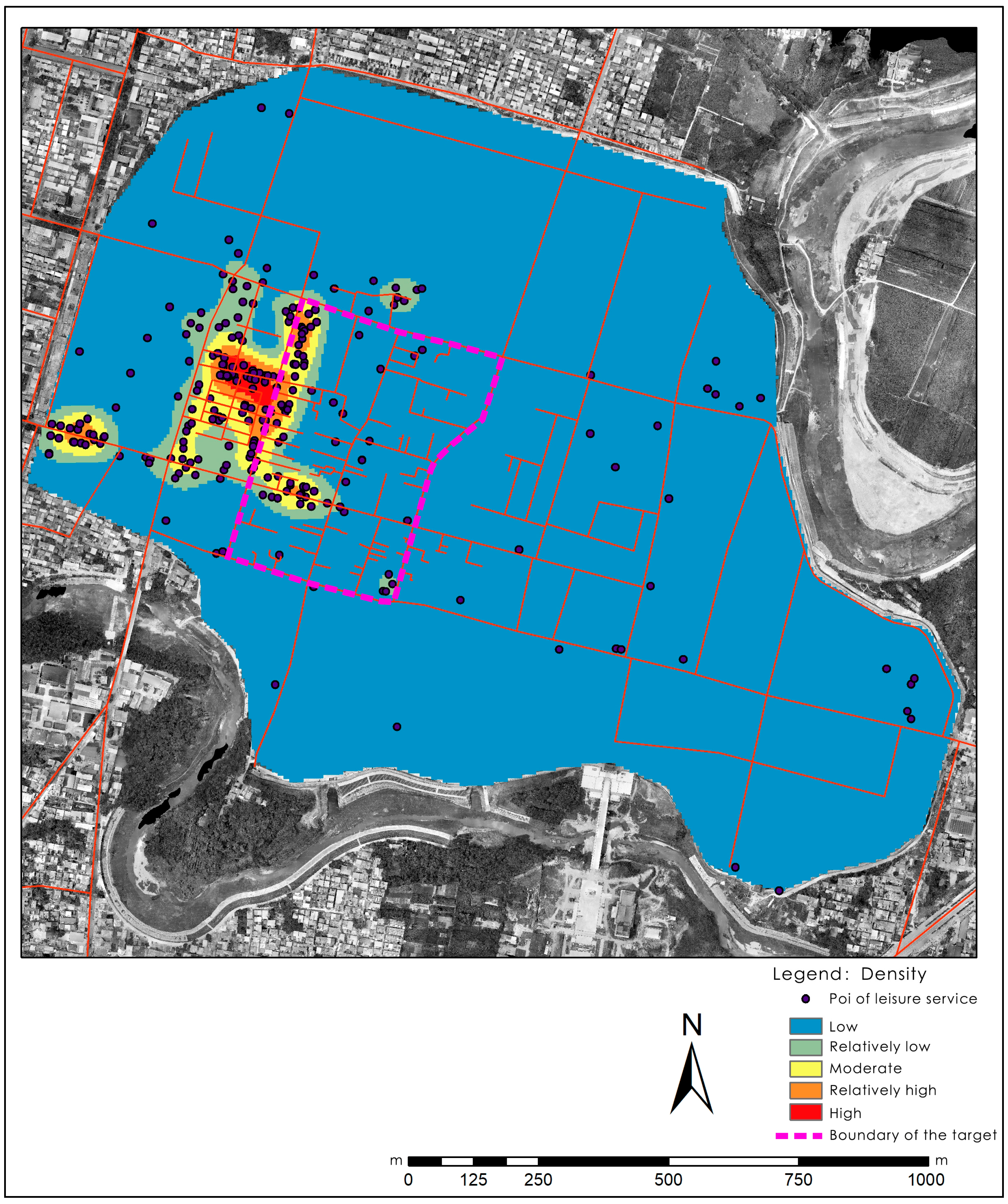
ArcGIS 10.8 enables the loading and analysis of geospatial data with real-world geographic coordinates. Using ArcGIS 10.8, geographic coordinate information can be extracted and utilized to visually represent the service radii and distribution densities of various facilities. Building heights within the target blocks were analyzed by mapping DSM data in conjunction with building SHP files. The locations of public spaces, park green areas, bus stations, and public restrooms within and around the target blocks were mapped using Baidu Maps and field surveys. Service radius analyses of these public facilities were conducted in ArcGIS 10.8. Additionally, POI data for leisure and entertainment facilities—including accommodations, restaurants, and shopping centers—within the city wall area of Shedian Town were obtained from Gaode Maps. Kernel density analysis of the POI data was performed in ArcGIS 10.8 to visualize the spatial distribution of leisure and entertainment facilities. The formula used for kernel density estimation is as follows:
F x = 1 n h i = 1 n k x x i h
where F(x) represents the estimated value from kernel density analysis, n is the total number of leisure and entertainment facilities within the study area, k is the kernel function, xxi is the distance between the estimation point and the observation point, and h is the bandwidth of the kernel density estimate [39].
Semantic segmentation algorithms enable the rapid processing of large volumes of images, and the Two-Step Road app can record the geographic coordinates of captured photographs. By integrating these two technologies, the average green view index at different locations within the target blocks can be efficiently calculated and visually represented by ArcGIS 10.8. Therefore a semantic segmentation algorithm was applied to analyze the green view index (GVI) of the street view images from the target blocks. Based on the image coordinate information, the GVI distribution was visualized in ArcGIS. The green-view index at each location is calculated as the average of the green-view index derived from street-view images taken in four directions at that location, the calculation formula is as follows:
G V I n = i = 1 4 g i , n i = 1 4 a i , n
In the equation, GVIn denotes the green-view index at sampling point n; gi,n is the sum of pixel areas corresponding to trees, shrubs, and grassland at sampling point n in view direction i; and ai,n represents the total pixel area of the image captured at sampling point n in direction i.
Grasshopper, used in conjunction with the Ladybug plugin, facilitates the intuitive analysis of multiple indicators, including thermal comfort, indoor daylighting, and solar exposure, by integrating building models with climatic data and visualizing their spatial distribution on within the model. Thus, simulations of sunlight exposure and Universal Thermal Climate Index (UTCI) for the target blocks were conducted by using Grasshopper, based on climate data and the white model of the target blocks.

3. Analysis

3.1. Block Safety

3.1.1. Fire Safety

  • Building Height
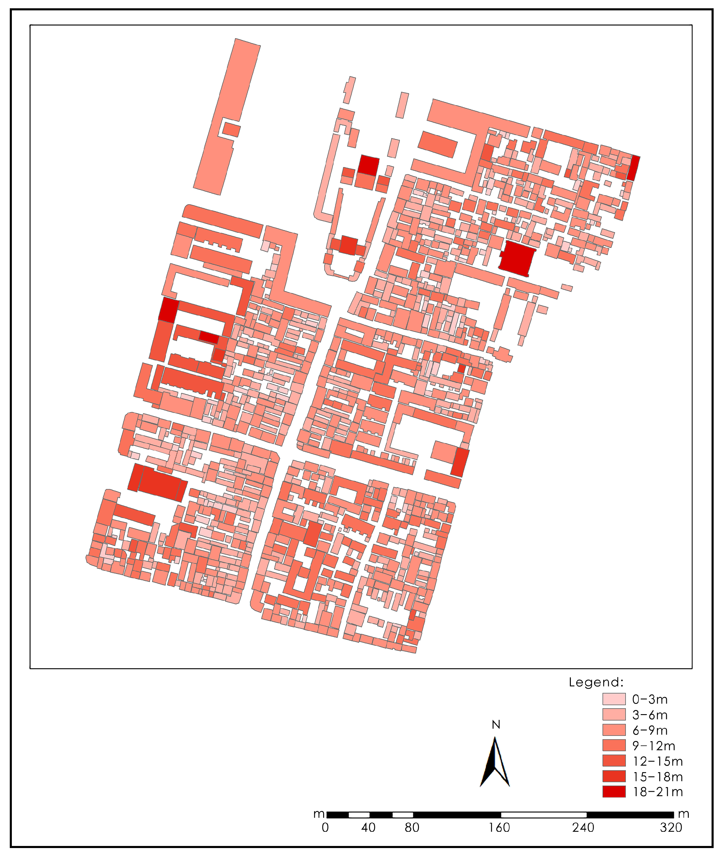
As shown in Figure 3, the majority of buildings within the target blocks range from 3 to 9 m in height, with single-story and two-story structures predominating, which are classified as being in an extremely healthy condition. Only five buildings exceed 18 m. Except for the main hall of the Shan-Shan Guild Hall, the remaining four are modern constructions that disrupt the harmony of the blocks’ traditional architectural style and also increase the difficulty of firefighting operations. Based on these observations, the overall building height in the target blocks is assessed as relatively healthy.
2.
Building Density
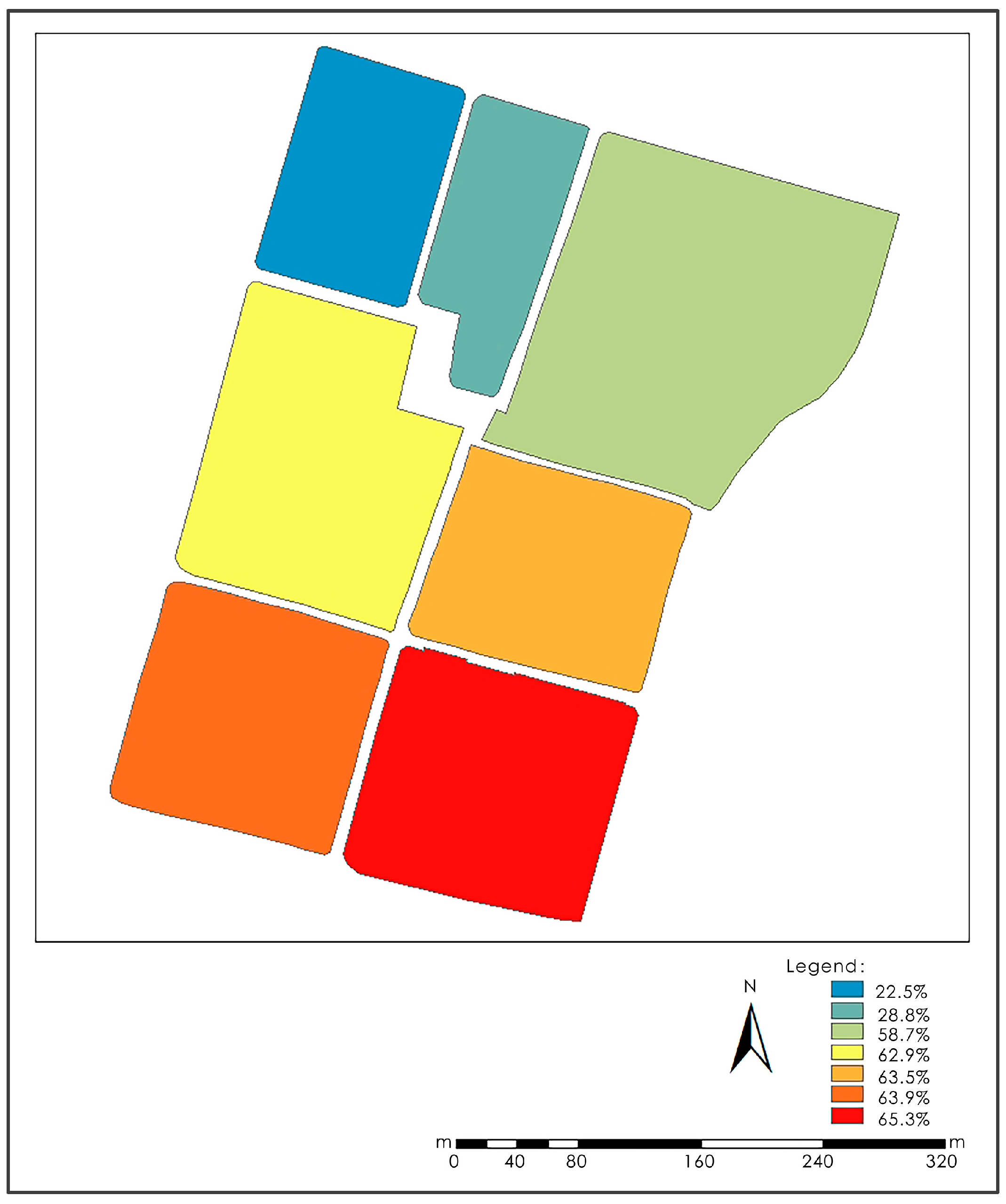
Figure 4 shows the Building Density. Excessive building density not only results in overcrowded living conditions, a lack of public activity spaces, and the proliferation of sanitation blind spots but also facilitates the rapid spread of fires, thereby increasing firefighting challenges. The assessment results indicate that the building densities of blocks A and B are 22.5% and 28.8%, respectively, falling within the extremely healthy and relatively healthy ranges. In contrast, blocks C, D, E, F, and G all exhibit building densities exceeding 50%, which are rated as being in an extremely unhealthy state. Notably, block A consists only of a row of commercial buildings, with the majority of its area occupied by a plaza, while block B, which contains the Shan-Shan Guild Hall, is also not primarily residential. The remaining five blocks, however, contain a large number of residential buildings, suggesting that living conditions are strained and that the overcrowded spaces impede firefighting efforts. According to the evaluation framework, the overall building density of the target blocks is classified as extremely unhealthy.
3.
Floor Area Ratio
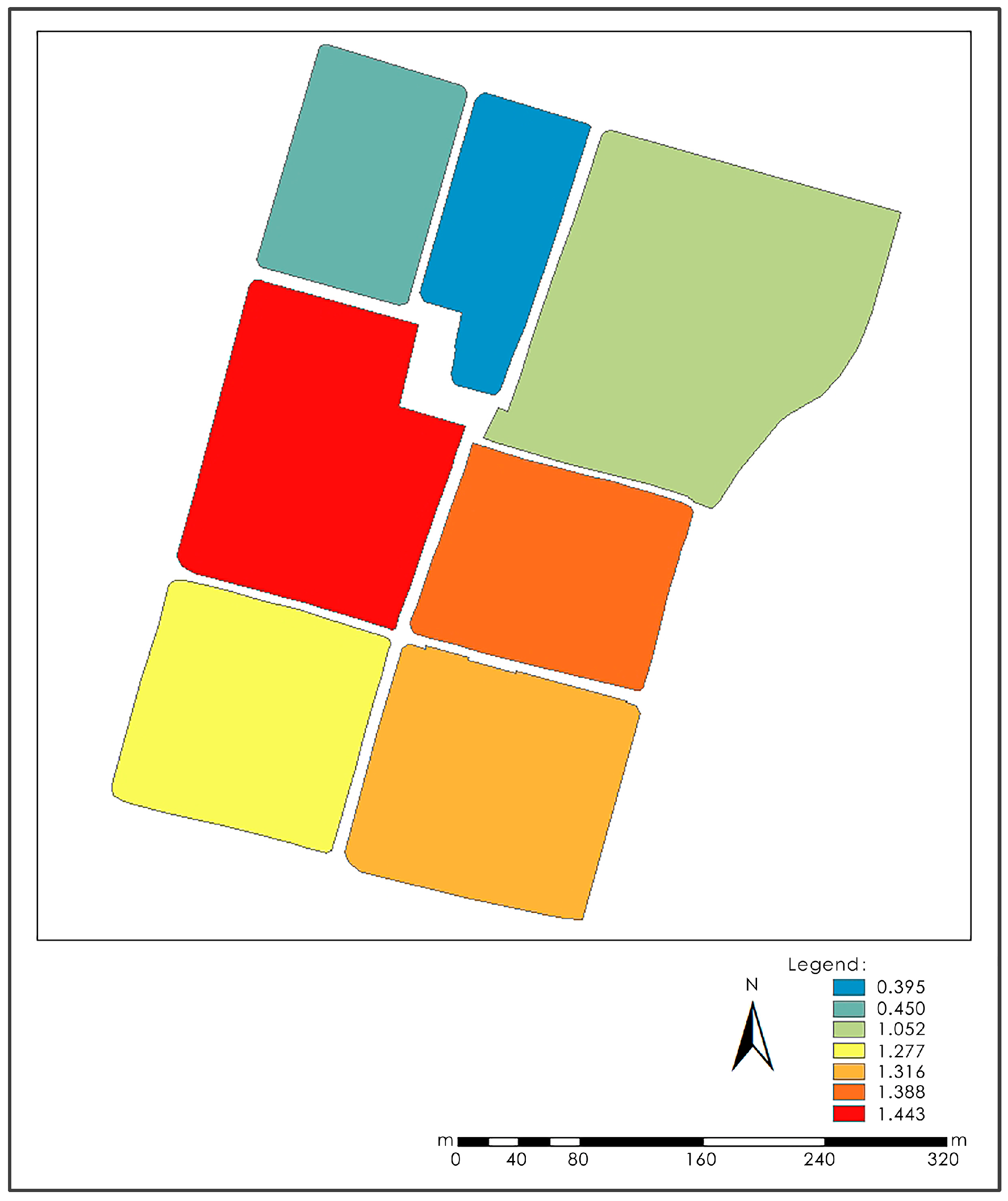
Figure 5 shows the plot ratio of these blocks. The plot ratios of blocks A and B, which serve as non-residential functional areas, are below 1.0 and are rated as being in an extremely healthy state. Block C exhibits a relatively healthy plot ratio, while block F falls within the generally healthy range. In contrast, blocks D, E, and G all have plot ratios exceeding 1.3 and are rated as being in an extremely unhealthy state, with block D exhibiting the highest plot ratio. Overall, the plot ratio of the target blocks is classified as relatively unhealthy. The primary factor contributing to the elevated plot ratios is the presence of modern multi-story buildings with large volumes, which disrupt the traditional fabric of the blocks and compromise both the continuity of the streetscape and the traditional aesthetic.
4.
Fire Truck Accessibility
Figure 6 shows the Fire Truck Accessibility of streets. Through measurements and statistics, it was found that the widths of all streets within the target blocks meet the requirements for fire truck lanes. However, there are other factors that impede fire truck access. Investigations revealed that at the entrances of South Ciqi Street (southern end), North Ciqi Street (northern end), East Wancheng Street (western end), and West Tianping Street (eastern end), obstacles such as roadblocks and decorative archways are present, with widths around 3.3 m. These obstacles prevent fire trucks from entering the streets. As a result, these five streets are classified as relatively unhealthy. In addition, long-term parking of vehicles on Dangpu Alley, South Zhongxin Street, and Tongqi Street has blocked fire truck access, rated as being in a generally healthy state. In summary, the overall accessibility of fire trucks within the blocks is classified as relatively unhealthy.

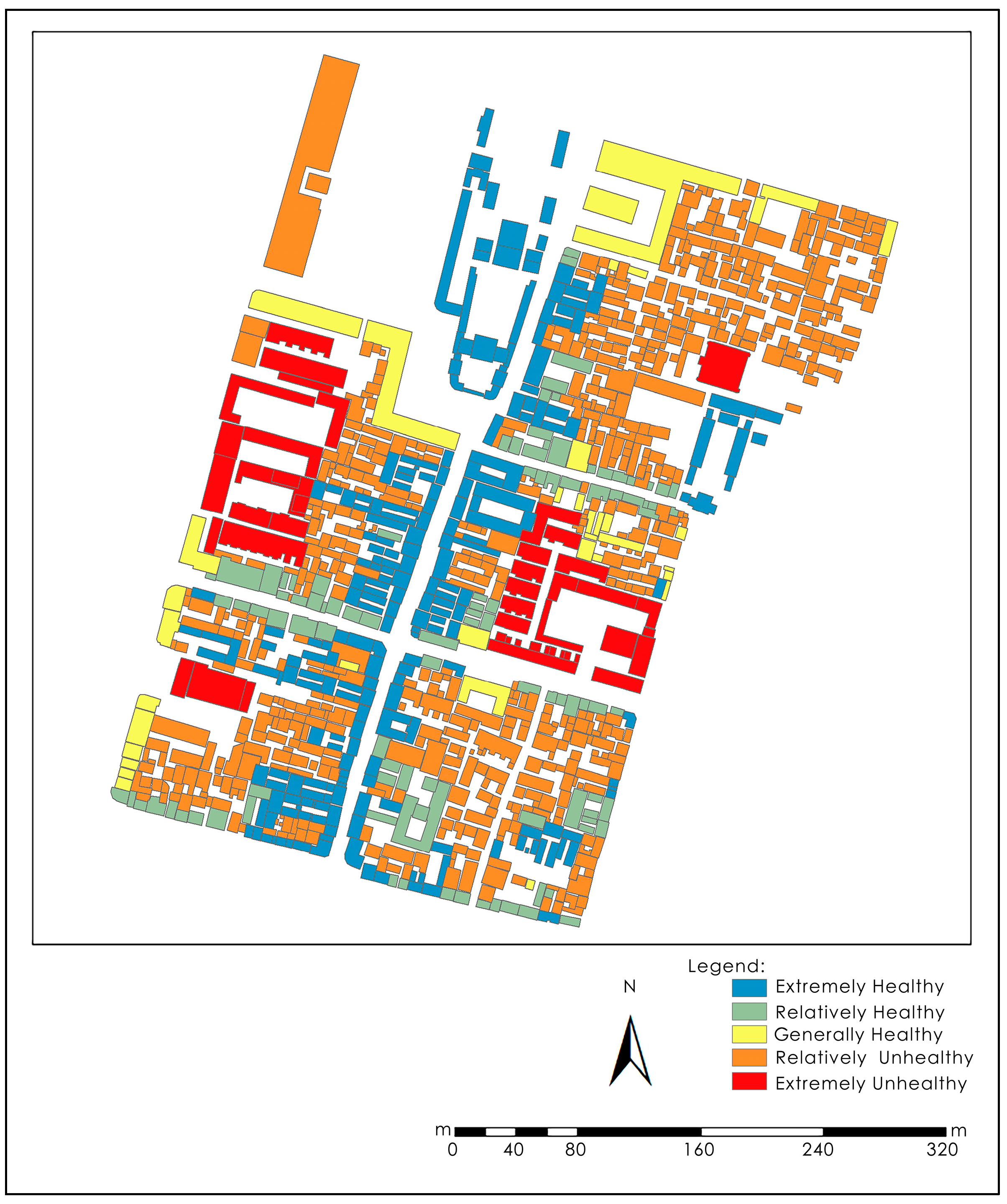
3.1.2. Residential Safety

Figure 7 shows the Building Quality. Commercial buildings, historical buildings, and cultural heritage structures located along the streetfronts of the blocks are either relatively recent or have undergone systematic protection and renovation. These buildings are generally well-preserved in both structure and appearance, with most classified as relatively healthy or extremely healthy. In contrast, the majority of residential buildings within the blocks, along with some historical and cultural heritage structures, exhibit poor structural and aesthetic conditions and are classified as relatively unhealthy or extremely unhealthy. Consequently, the overall building quality within the target blocks is assessed as relatively unhealthy.

3.1.3. Traffic Safety

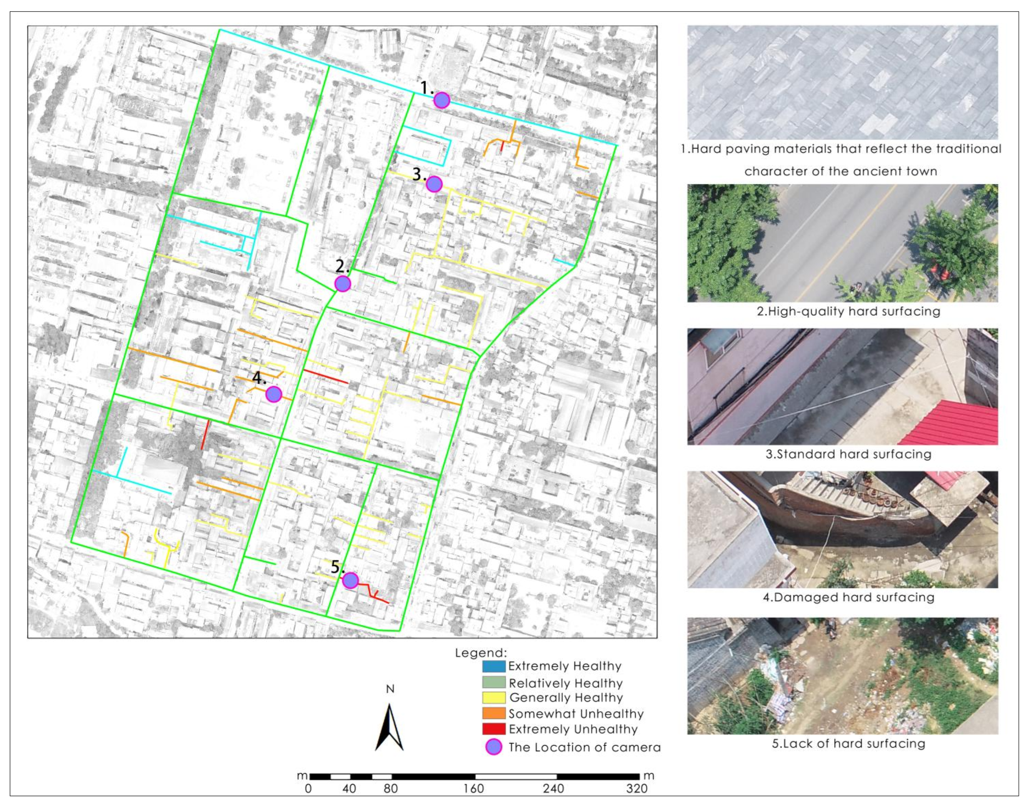
Figure 8 shows the road surface materials. The main streets within the blocks are predominantly paved with flagstones, which remain largely intact and are aesthetically consistent with the traditional town style, reflecting an extremely healthy state. The alleyways inside the blocks are mainly paved with cement, although several of them have experienced varying degrees of damage at the cement surface, rated as being in a relatively unhealthy condition. Additionally, there are four unpaved dirt roads in the target blocks, although their total length constitutes a small proportion of the overall road network. In summary, the evaluation of road surface materials is classified as generally healthy.

3.2. Block Comfort

3.2.1. Sunlight Exposure

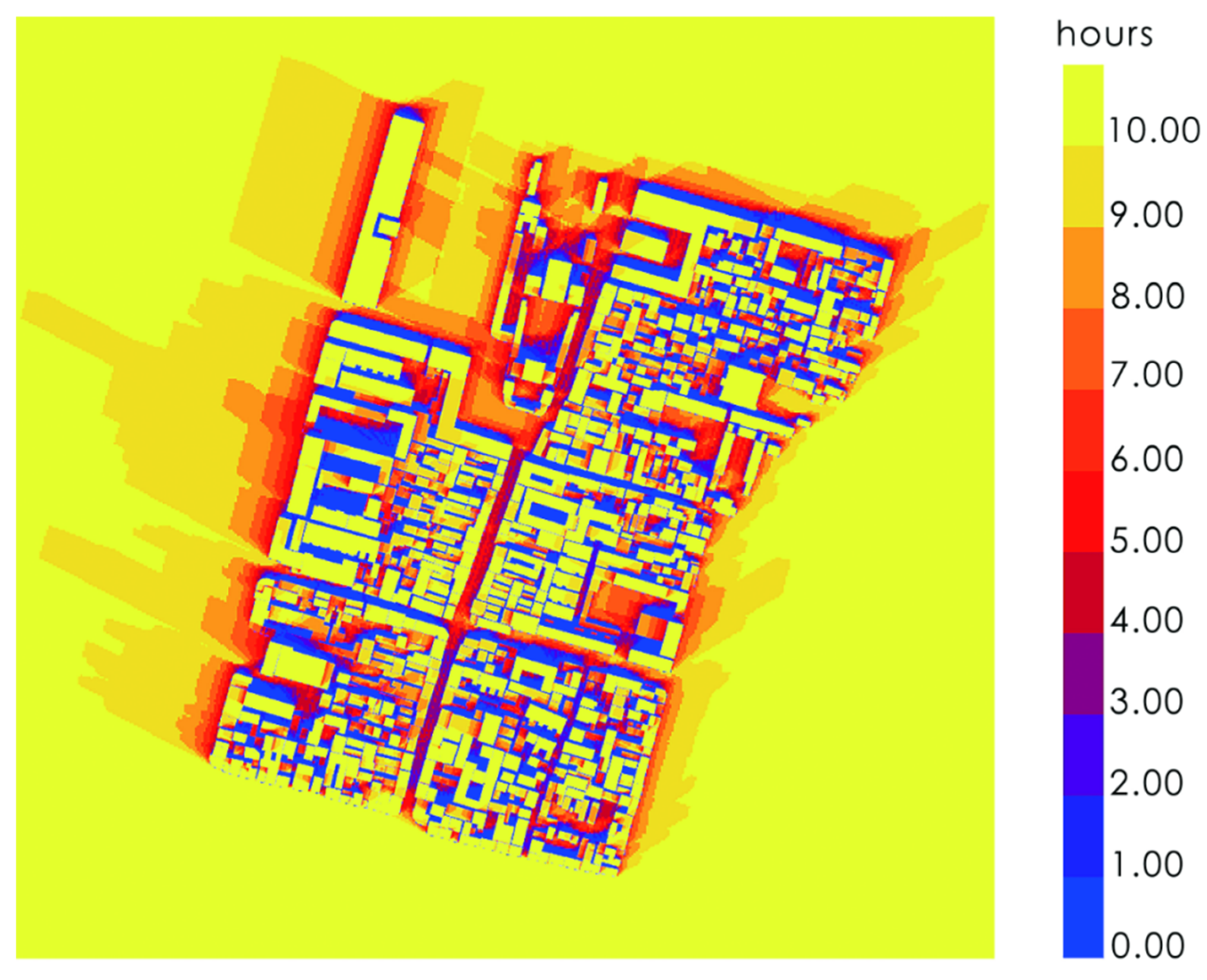
Figure 9 shows the sunlight exposure condition. According to the Project code for residential building, the duration of sunlight in urban residential areas must not fall below 2 h on the winter solstice and 1 h in the Great Cold solar term [34]. In this study, the duration of sunlight on the winter solstice was selected as a key indicator for the health assessment. The results of the sunlight analysis indicate that most residential buildings in the blocks fail to receive more than 2 h of sunlight on the winter solstice. Only a few buildings along the street and larger public buildings with spacious courtyards achieve over 2 h of sunlight on this day. As a result, the sunlight conditions of the buildings in target blocks are classified as extremely unhealthy.

3.2.2. Thermal Comfort

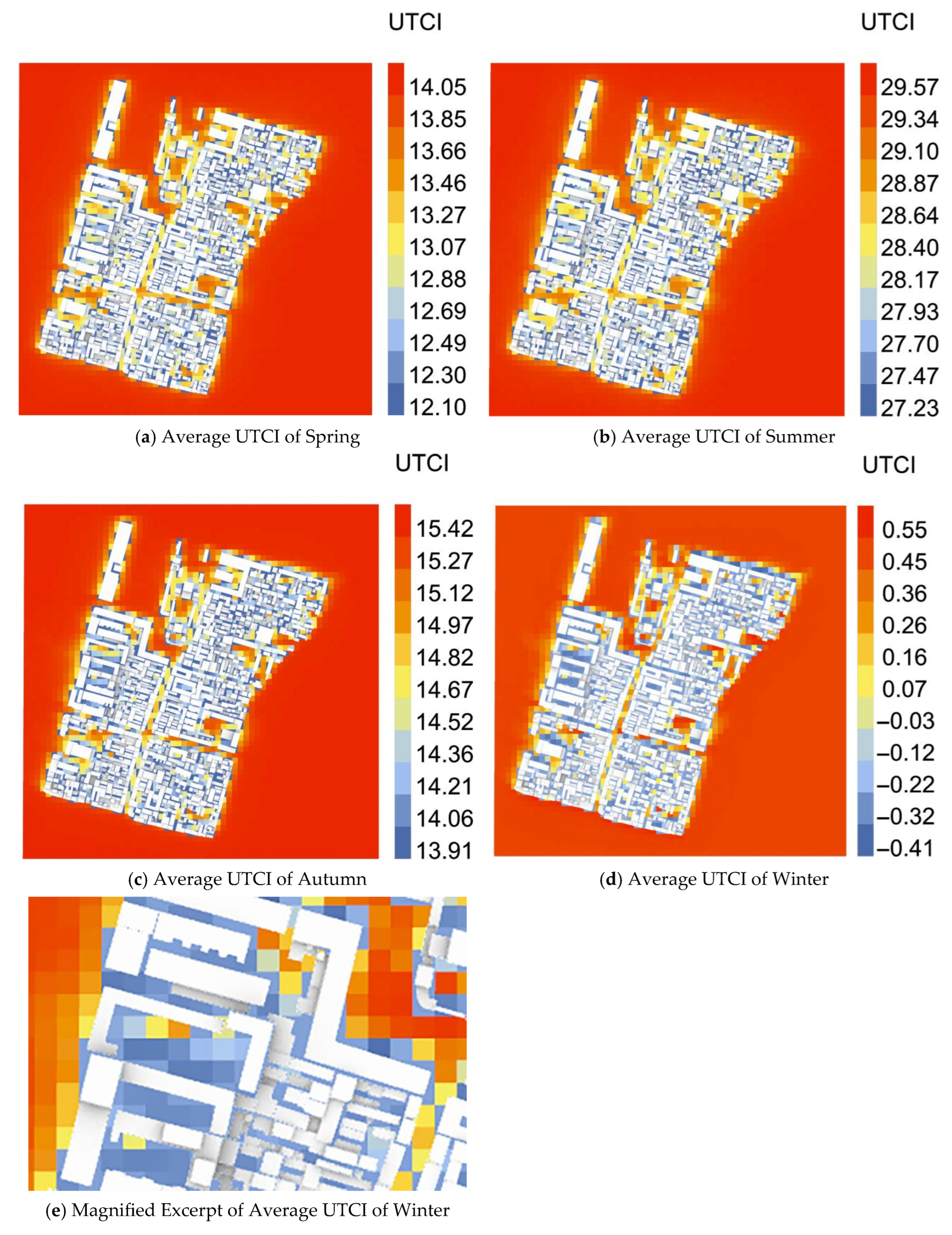
The Universal Thermal Climate Index (UTCI) is a climate comfort index used to describe human comfort levels under specific climate conditions. This index integrates various factors such as temperature, humidity, wind speed, and the degree of environmental enclosure, and it is one of the most widely used indices for assessing climate comfort [40]. The relationship between UTCI values and human comfort is shown in Table 3 [41].
Figure 10 illustrates the distribution of UTCI values across different seasons within the blocks. The results indicate that the average UTCI values for spring and autumn fall within the range of 9–26, representing a state of no heat stress. In contrast, summer UTCI values span from mild heat stress to high temperatures, while winter values fall between mild and moderate cold stress. This suggests that local residents are exposed to mildly and moderately uncomfortable outdoor thermal environments during two seasons of the year. According to the evaluation system, the UTCI for target blocks is classified as generally healthy.

3.3. Block Ecology Nature

3.3.1. Social Ecology

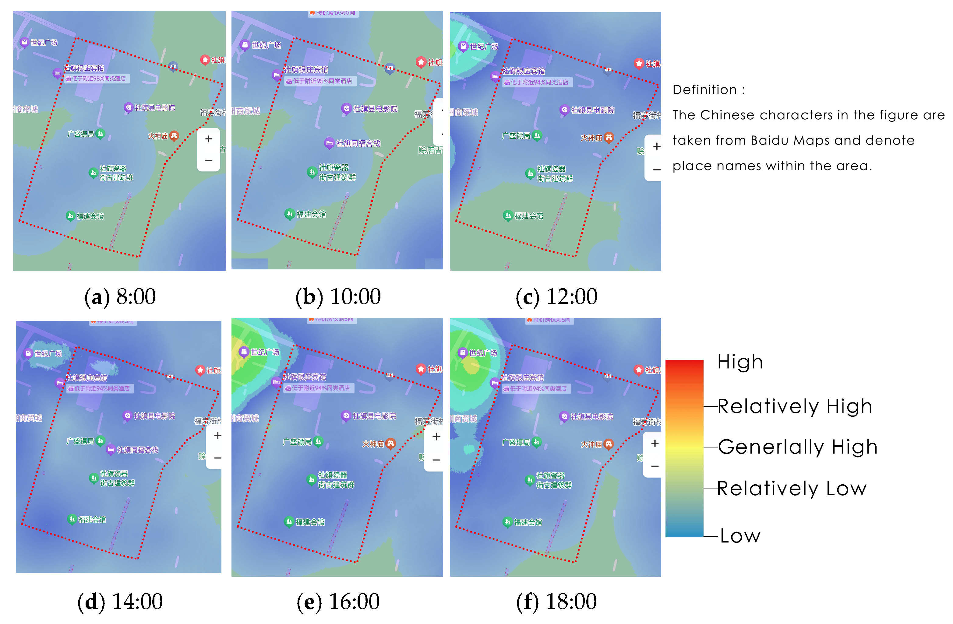
A lower intensity of human activity contributes to a quieter atmosphere within the blocks, being conducive to the physical and mental well-being of residents within the target blocks.
Figure 11 illustrates the crowd heat distribution in the target blocks at 2 h intervals, from 8:00 AM to 6:00 PM. The results show that the intensity of human activity within the target blocks is at a low level, with the commercial street on the west side of target blocks experiencing higher foot traffic. According to the evaluation system, the intensity of human activity in the target blocks is categorized as extremely healthy.

3.3.2. Natural Ecology

There are currently no public park green spaces within Shedian Town, and the parkland proposed in the Planning document has not yet been constructed. Therefore, according to the evaluation system, the current state of public parks green spaces is categorized as extremely unhealthy. However, both sides of the Pan River and Zhao River feature expansive linear natural green landscapes, which are planned for redevelopment into high-quality parklands according to the Planning. Once completed, the coverage of public park green spaces in the target blocks is expected to reach 90%.
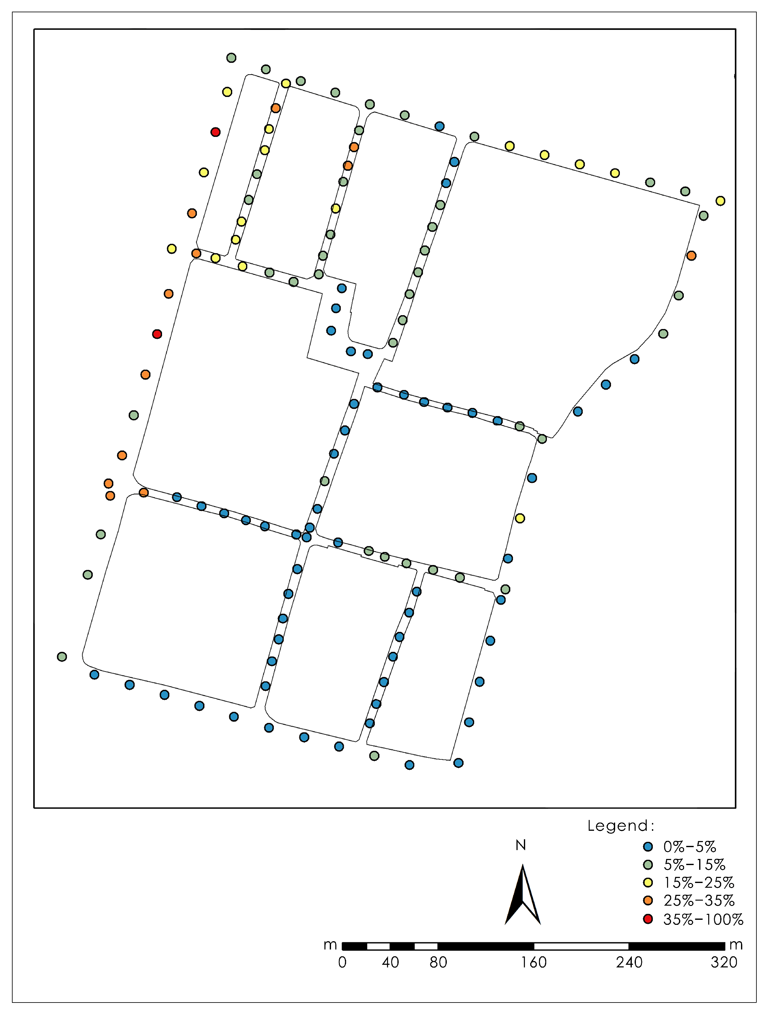
Figure 12 shows the green visibility index at different locations along the internal roads of the blocks. Figure 13 presents the semantic segmentation results of street-view imagery captured in four directions at a specific sampling point.
Through semantic segmentation of street-view image data, it was found that most areas along Ciqi Street, Dangpu Alley, East Wancheng Street, Yongning Street, and Gongan Street within the blocks have a GVI ranging from 0% to 5%, rated as being in an extremely unhealthy state. On the other hand, the GVI in most areas of West Tianping Street, Yongqing Street, and Yongtai Street falls within the range of 5% to 15%, which is categorized as relatively unhealthy. In Area A, the GVI along the roadway ranges between 15% and 25%, rated as being in a generally healthy state. The streets on the western edge of the blocks, such as Luodian Street, as well as those on the northern side, like West Shanhuo Street and Wukuichang Street, have GVI ranging from 15% to over 35%, rated as being in a generally to extremely healthy state. The southern side, including Old Street and West Neige Street, has an overall GVI below 5%, rated as being in an extremely unhealthy state. Similarly, most areas along Zhongxin Street and Tongqi Street on the eastern side also exhibit GVI below 5%. These results demonstrate that both the target blocks and its surrounding areas have low levels of greening. As a result, the GVI in the target blocks is categorized as relatively unhealthy.

3.4. Block Convenience

3.4.1. Accessibility of Public Services

  • 500 m Service Radius of Public Spaces (≥300 m2)
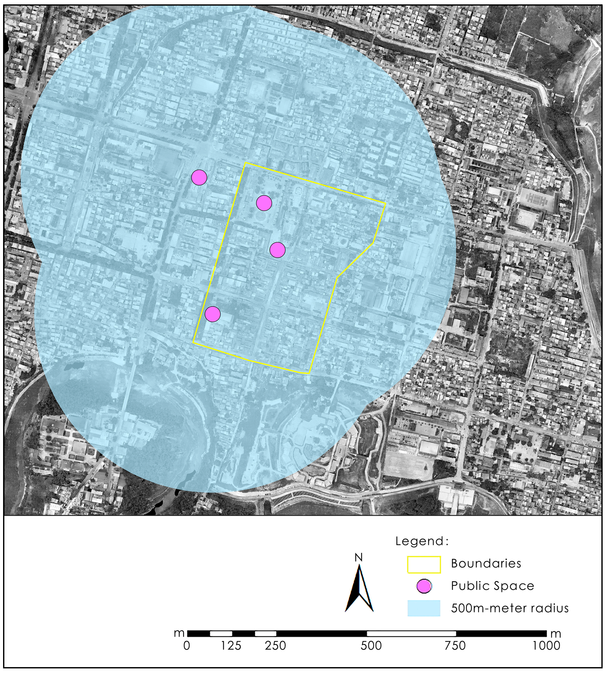
Figure 14 illustrates the locations of public spaces near and within the target blocks, along with the coverage area of their 500 m service radius.
There are three public spaces larger than 300 m2 within the target blocks, namely the Shedian Cultural Square to the west of the Shan-Shan Guild Hall, the south square of the Shan-Shan Guild Hall, and the front square of the Dongsheng Furniture Market. In addition, there is Century Square on the western side of the blocks, which also covers an area greater than 300 m2. Using ArcGIS 10.8, a 500 m radius was applied to analyze the four public spaces. The results show that the entire target blocks is within the service radius of these public spaces, with a coverage rate of 100%. According to the evaluation system, this indicates that the public spaces are in a extremely healthy state.
2.
400 m Service Radius of Bus Stops
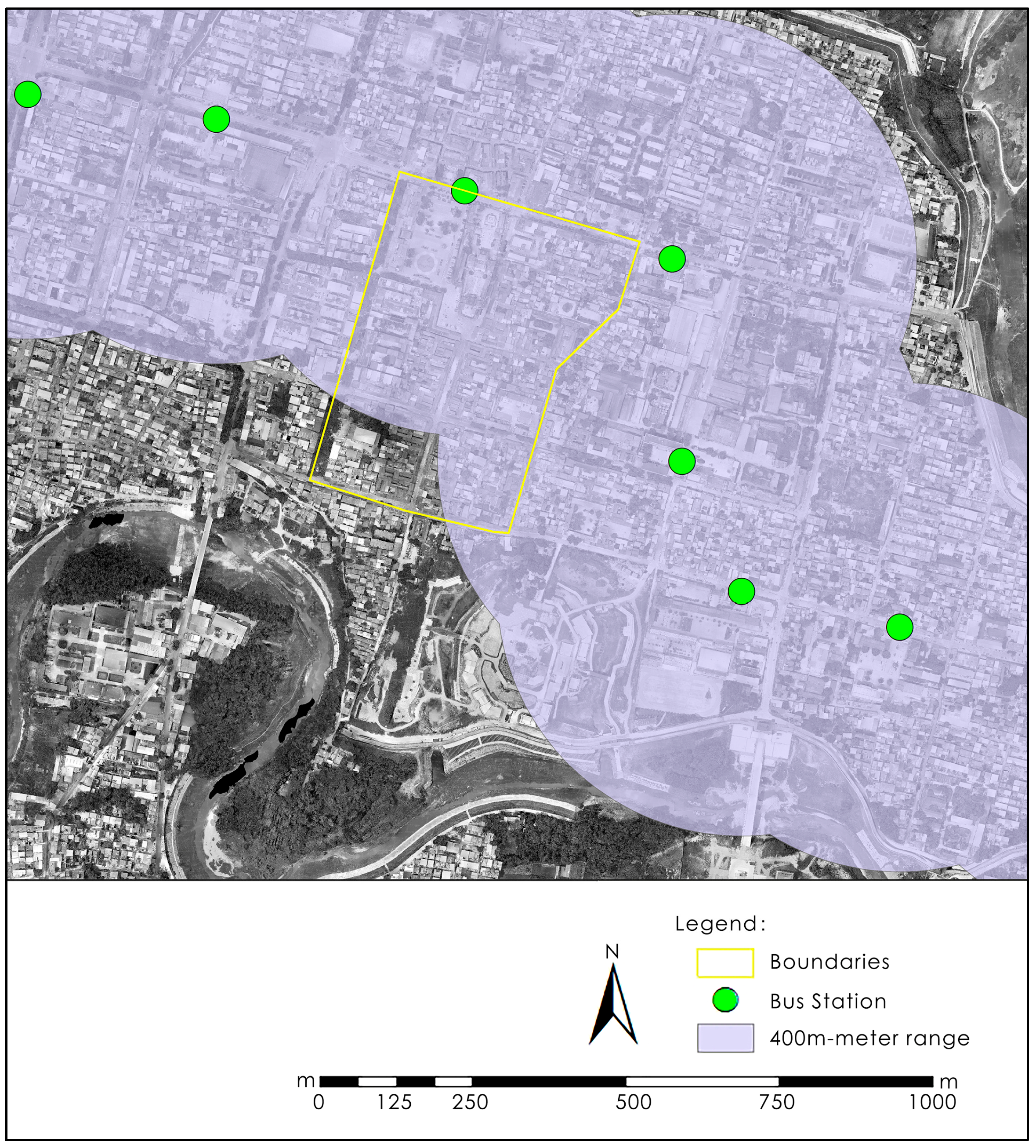
Figure 15 shows the locations of bus stops near and within the target blocks, along with the coverage area of their 400 m service radius. The results show that the coverage rate of bus stations within the target blocks is 86.5%, rated as being in a relatively healthy state.
3.
400 m Service Radius of Public Restrooms
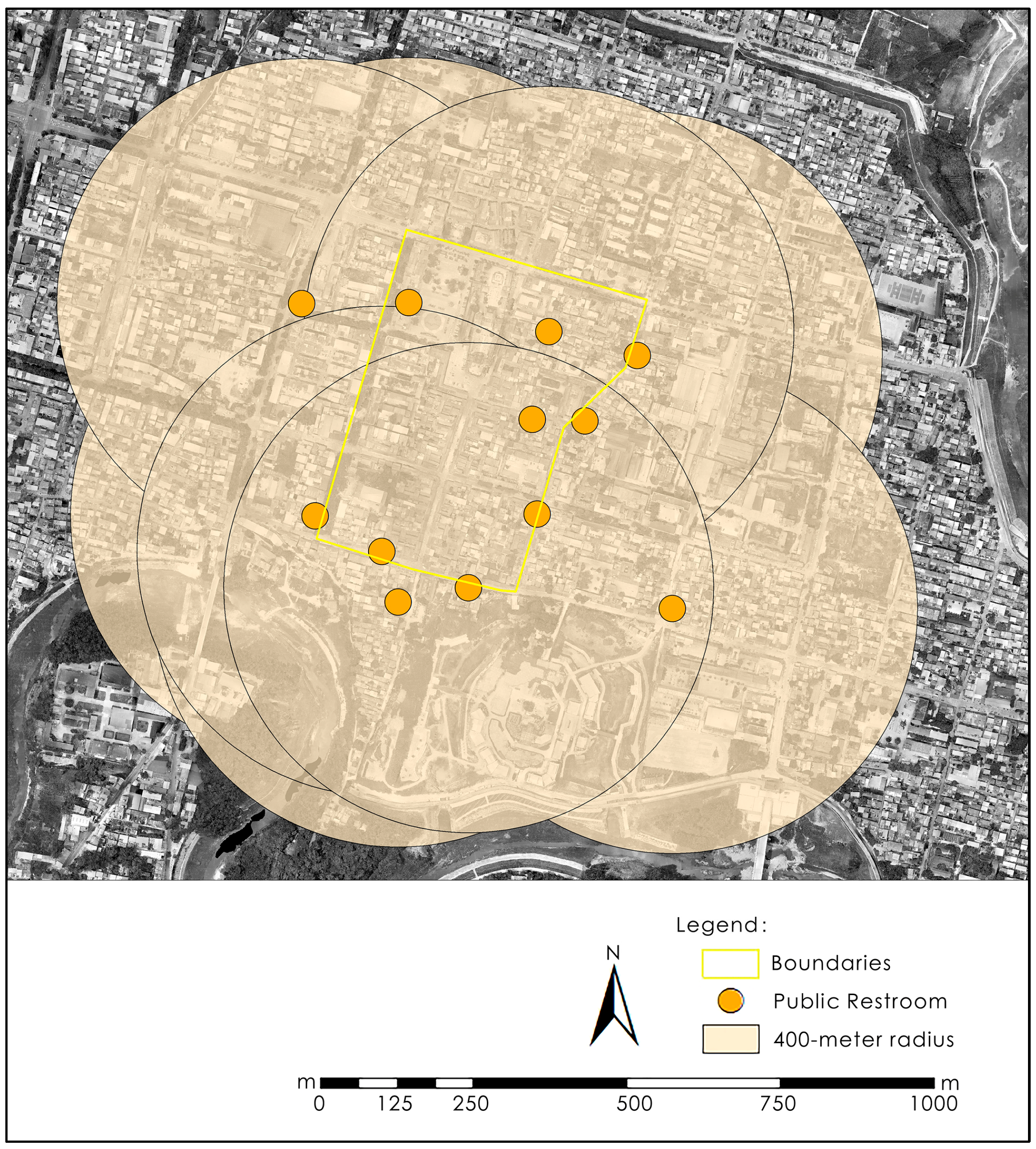
Figure 16 illustrates the locations of public restrooms near and within the target blocks, along with the coverage area of their 400 m service radius.
The results indicate that the entire target blocks falls within the service range of public restrooms, achieving a coverage rate of 100%. Based on the evaluation system, the public restroom service is rated as extremely healthy.

3.4.2. Convenience of Commercial and Leisure Services

Figure 17 shows the kernel density distribution of various recreational facilities within the walls of Shedian Town.
Leisure and service facilities in Shedian Town are primarily concentrated on the western side, particularly along South Luodian Street, North Luodian Street, Middle Luodian Street, and Wukuichang Street. The target blocks are adjacent to streets with a high density of leisure and service facilities, which significantly enhances the convenience and vibrancy of residents’ daily lives. Consequently, the evaluation of leisure and service facilities surrounding the target blocks is assessed as relatively healthy.

3.5. Block Cultural Nature

3.5.1. Traditional Streetscape

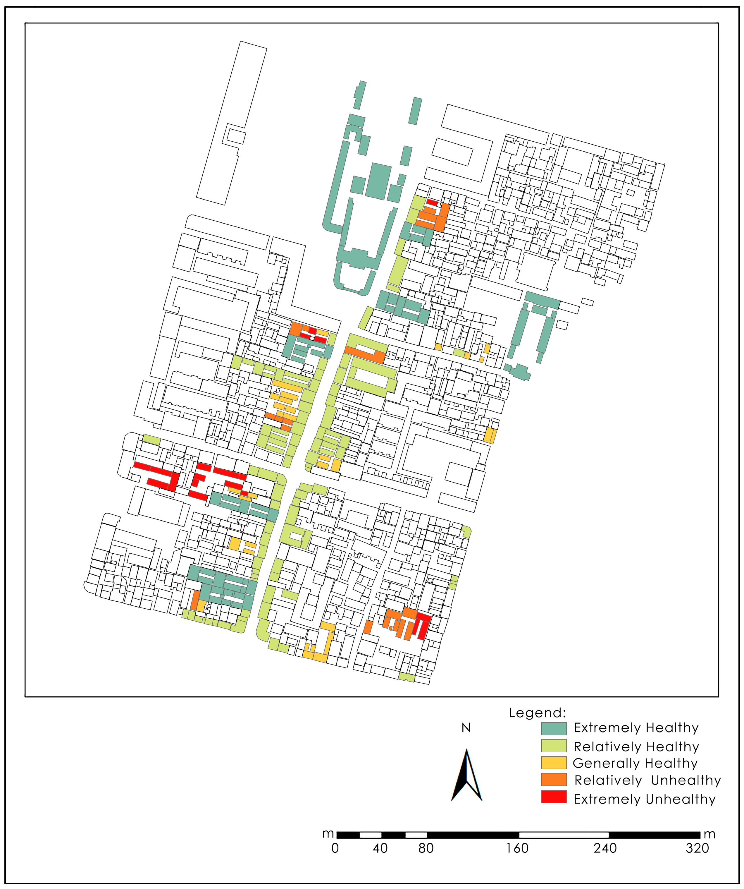
Figure 18 illustrates the architectural styles of various buildings within the target blocks. The historical and cultural buildings along the street frontage of the target blocks have been comprehensively protected and utilized. However, there are still a small number of historical and cultural buildings within the blocks that have not been well preserved or utilized, and some are even abandoned or damaged. Only a few modern buildings along the street have undergone facade renovation to achieve harmony with the traditional style. Most modern buildings within the blocks, however, are either incompatible or highly discordant with the traditional architectural style, rated as being in an extremely unhealthy state. In conclusion, the traditional architectural style of the target blocks is rated as relatively unhealthy.

3.5.2. Revitalization and Adaptive Reuse of Cultural Heritage

Figure 19 shows the current usage status of historic and cultural heritage buildings within the target blocks.
There are currently 47 cultural heritage buildings and 23 historical buildings in the target blocks. Among the cultural heritage buildings, most are well-preserved, with 7 serving as tourist attractions and 1 functioning as a museum and exhibition hall, all rated as extremely healthy; 3 have been renovated and converted into commercial shops, and 2 have been repurposed as guesthouses, rated as being in a relatively healthy state. There are 25 heritage buildings used as residential properties or in the traditional ‘shop-house’ form and are considered to be in generally healthy condition. There are 7 cultural heritage buildings currently abandoned, rated as being in a relatively unhealthy state, 3 are completely dilapidated and abandoned, in an extremely unhealthy state.
Among the historical buildings, there are 21 buildings used as small commercial shops or residential properties along the street and are rated generally healthy. One historical building is preserved but unused, rated as being in a relatively unhealthy state. One building has suffered severe damage and abandonment, classified as extremely unhealthy. Overall, the adaptive reuse of cultural heritage within the blocks remains in a generally healthy state.

4. Discussion

4.1. Primary Health-Related Challenges Facing the Target Blocks

Among the six indicators related to the safety of the target blocks, only two are classified as “healthy” indicating that the safety issues in the blocks are of significant concern, particularly in terms of fire safety and residential security.
The main issue concerning the comfort of the target blocks is the severe lack of adequate daylight exposure. Regarding the ecological aspects of the blocks, the social ecological nature is considered extremely healthy, with low pedestrian traffic within the target blocks, while the higher foot traffic in the surrounding area helps maintain its vibrancy without causing overcrowding. In contrast, the natural ecological nature is in an unhealthy state due to low levels of green coverage and the absence of surrounding green park spaces.
The overall convenience of the blocks is deemed healthy, owing to the completeness of public infrastructure both within and outside the blocks. In terms of cultural aspects, the traditional aesthetic of the blocks is incongruent, and the utilization of cultural heritage is fragmented and unevenly distributed.

4.2. Spatial Distribution Characteristics of Health-Related Issues

Among the 17 evaluation indicators, public service facilities such as public restrooms, recreational services, and the Universal Thermal Climate Index (UTCI) are generally in healthy or above-average condition, with these features predominantly located outside the district. In contrast, the eight indicators that fall into the “unhealthy” category are closely related to the residents’ living conditions, and these are mostly concentrated within the target blocks itself. The well-preserved and effectively utilized historical and cultural buildings are located along the street facades, while poorly maintained residential buildings and that lack adequate natural lighting are distributed in the interior of the block.
This suggests that the health issues of the target blocks are concentrated within their interior, where there is an urgent need to improve the spatial quality and living conditions. This is a common challenge faced by many historical blocks and heritage areas in China.

4.3. Strategies for Enhancing the Health Level of Historic Urban Blocks

4.3.1. Optimizing and Revitalizing Internal Public Spaces to Enhance Spatial Quality in Historic Blocks

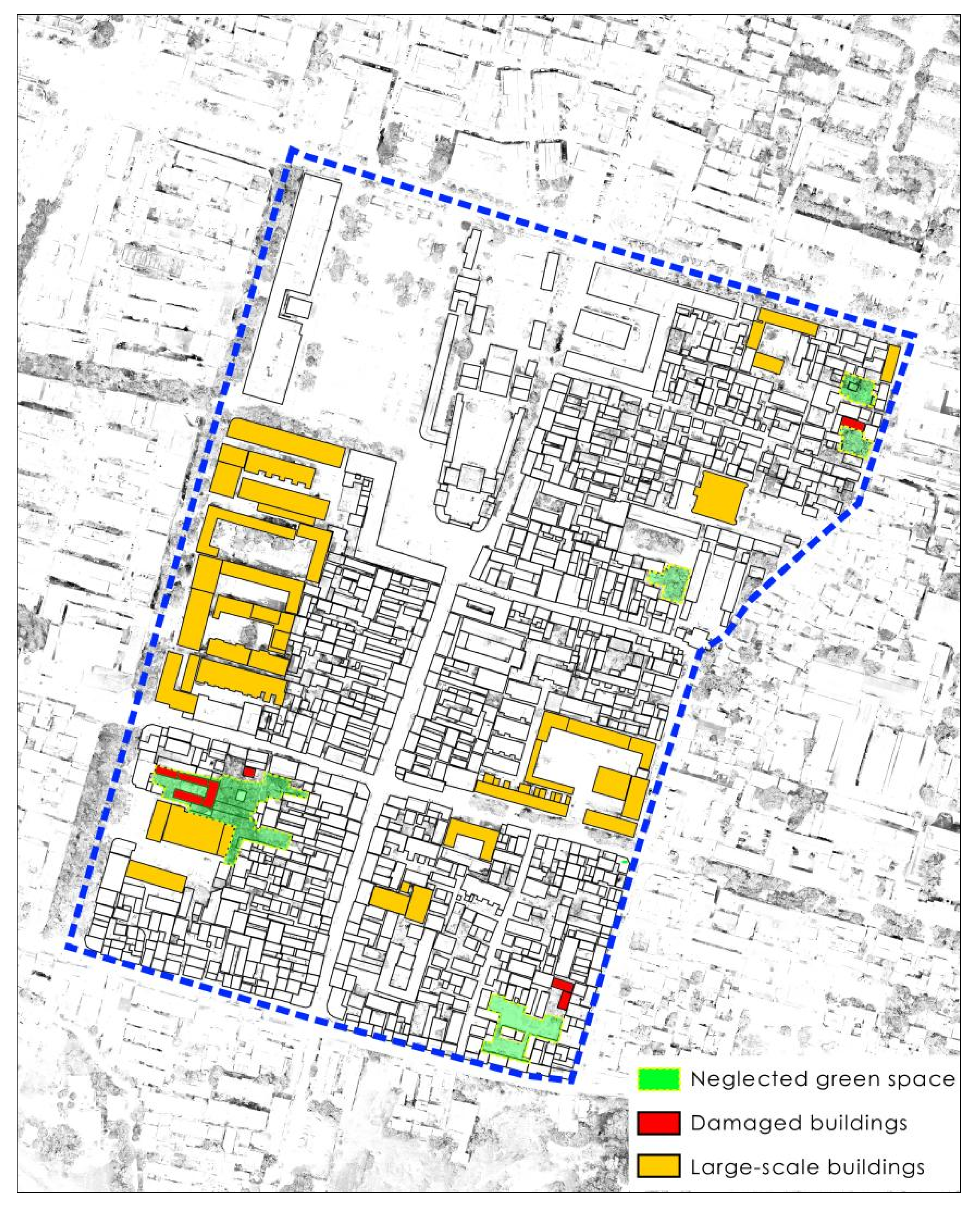
The internal public spaces of historic blocks are predominantly composed of linear alleyways, resulting in a relatively monotonous spatial experience. These areas are also prone to issues such as surface deterioration and poor management. Therefore, we need remove unauthorized constructions and installations encroaching upon alleyways, and we need revitalize neglected green spaces and adaptively reuse abandoned or dilapidated buildings, transforming them into pocket parks or other forms of small-scale public spaces, finally, we need repair and upgrading alley pavements to enhance both visual appeal and pedestrian safety. In addition, study results indicate that areas within the blocks with higher street green view ratios typically feature trees planted behind curbs and beneath building eaves along both sides of the street, enhancing greenery without occupying roadway space. Accordingly, additional trees could be planted along the curb at the junctions of building gables on street-facing facades, thereby increasing streetscape greenery while maintaining unobstructed access to building entrances. Furthermore, with the planned development of the Zhao River landscape belt, vacant land on the south side of the old street could be converted into a public square, creating a visual interface between the target blocks and the riverfront.

4.3.2. Preserving Traditional Dwellings to Enhance Residential Experience

The majority of residents in historic blocks are elderly, with younger generations opting for modern housing outside these blocks. The negative factors present within these blocks tend to have a more pronounced impact on the elderly population, and, over time, this could lead to a decline in residential occupancy, resulting in vacant, uninhabited homes and the loss of the vibrant local atmosphere. To address this, it is crucial to focus on the protection, restoration, and quality enhancement of the low-quality traditional housing within target blocks. These efforts should aim to improve the safety and comfort of residents, while also making the area more appealing to younger inhabitants, thus revitalizing the community and preserving its liveliness.

4.3.3. Relocating Non-Essential Functions to Minimize Negative Disruptions

Large-scale structures such as office buildings and modern apartment blocks within target blocks have encroached upon the space traditionally occupied by vernacular residences, severely disrupting both the daily lives of long-term residents and the integrity of the blocks’ historical character. These oversized buildings compromise the spatial texture and aesthetic coherence of the historic environment. To address this, functions that are incompatible with traditional residential life should be relocated, and the intrusive buildings should be either demolished or adaptively reused. Such interventions will help to relieve the spatial congestion within the blocks and significantly enhance the overall quality of life for its residents. Furthermore, buildings with architectural styles identified as “Extremely unhealthy” or “Relatively unhealthy” in the architectural style analysis should also be considered for demolition and reconstruction. Buildings with architectural styles classified as “Generally health” should undergo form and quality enhancement renovations, while those assessed as “Extremely healthy” and “Relatively healthy” should be preserved and maintained through routine upkeep.
Figure 20 highlights the internal elements of the target blocks that require optimization.

5. Conclusions

This study conducts a health assessment of the blocks along the Ciqi Street, Yongqing Street, and Yongtai Street in Shedian Town, Nanyang City, China, using a range of analytical methods, including multi-source data and semantic segmentation simulations. The conclusions indicate that safety concerns within the blocks are significant, particularly regarding fire safety and residential security. The primary issue affecting the blocks’ comfort is the severe lack of adequate daylight exposure. From an ecological perspective, the social environment is considered highly healthy. In contrast, the natural ecological environment is unhealthy due to low green coverage and the absence of surrounding park spaces. Overall, the target blocks are deemed convenient, owing to the completeness of public infrastructure both within and around them. Culturally, however, the traditional aesthetic is inconsistent, and the utilization of cultural heritage is fragmented and unevenly distributed.
Among the 16 evaluation indicators, the eight indicators classified as “unhealthy” are closely linked to residents’ living conditions and are mostly concentrated within the target blocks. Well-preserved and effectively utilized historical and cultural buildings are located along street facades, whereas poorly maintained residential buildings lacking adequate natural lighting are situated within the interior of the blocks.
Based on the study of relevant theories, this study constructs a health assessment system for historical blocks from five dimensions, which enriches the scope of health assessments for historical blocks and can also serve as a reference for similar studies on other urban legacy resources, such as aging neighborhoods or old industrial zones. By combining machine learning, GIS analysis, and other computational modeling techniques with traditional fieldwork methods, this study enhances the efficiency of data analysis, such as images and 3D models, providing technical references for related research.
In terms of the assessment system’s construction, this study focuses on the built environment, natural environment, and social environment of both the historical block itself and its surrounding areas. However, it lacks systematic analysis and focus on the subjective awareness and opinions of residents regarding health. Due to the constraints of technical methods and available data, the assessment system could benefit from the inclusion of more refined indicators. Additionally, the application of big data and machine learning technologies should be further strengthened, reducing the reliance on traditional methods.

Author Contributions

Conceptualization, B.X.; methodology, B.X., R.Z. and H.L.; validation, B.X. data curation, B.X.; writing—original draft preparation, B.X.; writing—review and editing, B.X., R.Z., L.Z. and H.L.; supervision, L.Z. and H.L.; funding acquisition, H.L. All authors have read and agreed to the published version of the manuscript.

Funding

This research was funded by Research and Application of BIM Model for Low-carbon Healthy Community in Featured Towns (231111520800).

Data Availability Statement

Data are contained within the article.

Conflicts of Interest

The authors declare no conflicts of interest.

References

  1. Zuo, L.; Zeng, X.X. Research on historic districts preservation and renewal modes from the perspective of urban renewal: A case study on Greenwich Village historic district in New York. J. Hum. Settl. W. China 2024, 39, 91–97. [Google Scholar] [CrossRef]
  2. Zhang, Z.F.; Gao, W. Research on the Construction of the Outdoor Built Environment Health Impact Model for a Healthy Community. S. Archit. 2023, 1, 44–50. [Google Scholar] [CrossRef]
  3. Outline of the Healthy China 2030 Plan. Available online: https://www.gov.cn/zhengce/2016-10/25/content_5124174.htm:2024-12-19 (accessed on 25 November 2024).
  4. Gao, W.; Xiong, R.; Chen, X.Q. The Current Situation and Assessment of Health Impact of the Built Environment in the Unit Communities: An Empirical Research of Chengdu. Huazhong Archit. 2022, 40, 40–46. [Google Scholar] [CrossRef]
  5. Dai, A.M.; Cao, S.Y.; Zhu, S.Q.; Zhou, H.M.; Zhang, T.; Chen, C.F. Research on Health Assessment of Aging Communities: A Case Study of Lüxianting Sub—District in Yueyang City. Future City Des. Manag. 2023, 1, 53–57. [Google Scholar]
  6. Wang, H.Y.; Li, S.A.; Han, L.; Mo, S.T.; Wen, H.F. Evaluation and analysis of health status of drainage pipelines in Nanning. Water Wastewater Eng. 2020, 56, 132–137. [Google Scholar] [CrossRef]
  7. Zhou, H.; Jiang, S.L.; Zhou, C.H.; Ying, S.Z.; Xu, X.Y. Exploration of health assessment and model restoration for urban water supply network. Water Wastewater Eng. 2021, 57, 491–494. [Google Scholar] [CrossRef]
  8. Zhou, J. Health Evaluation Method of Utility Tunnel Based on Multi-source Monitoring. Chin. J. Undergr. Space Eng. 2021, 17, 918–924. [Google Scholar] [CrossRef]
  9. Zhang, Y.C.; Feng, J.Y.; Feng, C.; Lu, R.X.; Liu, C.H. Research on Land Use Planning of Zhengzhou City Based on Health Evaluation of Urban Forest Ecosystem. Landsc. Archit. Acad. J. 2023, 40, 32–41. [Google Scholar] [CrossRef]
  10. Liu, Z.Y.; Ren, L.S.; Bai, Y.J.; Zhao, Y.J.; Ding, A.Z. Health Assessment and Change Analysis of Yongding River Basin. Guangxi Sci. 2022, 29, 482–490. [Google Scholar] [CrossRef]
  11. Ni, Y.W.; Liu, Y.; Yan, S.Y.; AI, X.; Deng, X. Land Use Planning Based on Regional Ecosystem Health Assessment—A Case Study of Beijing. Chin. Landsc. Archit. 2020, 36, 110–115. [Google Scholar] [CrossRef]
  12. Zhang, Y.; Tang, H.; Huo, K.; Tang, J. Research on urban community street environment evaluation and optimization strategy under the concept of a healthy city: A case study of the Dingwangtai area of Changsha city. Buildings 2024, 14, 2449. [Google Scholar] [CrossRef]
  13. Fan, J.; Zheng, B.; Liu, J.; Tian, F.; Sun, Z. Research on child-friendly evaluation and optimization strategies for rural public spaces. Buildings 2024, 14, 2948. [Google Scholar] [CrossRef]
  14. Li, Y.; Tang, H. Health-oriented evaluation and optimization of urban square space elderly suitability: A case study of Yiyang City center. Buildings 2024, 14, 2482. [Google Scholar] [CrossRef]
  15. Huang, J.; Song, Y.; Sheng, Y.; Zhang, Y.; Hu, D. Restorative potential assessment of public open space in old urban communities in the context of aging—A case study of dabeizhuang community in maanshan, China. Buildings 2024, 14, 2671. [Google Scholar] [CrossRef]
  16. Wu, G.N.; Tan, J.Z. Research on Health Evaluation and Renovation of Streets and Alleys in Historic Blocks: Taking the Northwest Block of Zhongshan Road in the Ancient City of Lianzhou as an Example. Archit. Cult. 2023, 6, 209–212. [Google Scholar] [CrossRef]
  17. Li, J.H.; Zhang, W.J.; Xiao, S.Y.; Ren, B.B. Research on Health Assessment of Five Avenue Historic Cultural Blocks Based on Multi-Source Data. Mod. Urban Res. 2020, 6, 79–86. [Google Scholar] [CrossRef]
  18. World Health Organization. Integrating Health in Urban and Territorial Planning: A Sourcebook; World Health Organization: Geneva, Switzerland, 2020. [Google Scholar]
  19. Bafarasat, A.Z.; Cheshmehzangi, A.; Ankowska, A. A set of 99 healthy city indicators for application in urban planning and design. Sustain. Dev. 2023, 31, 1978–1989. [Google Scholar] [CrossRef]
  20. Cardinali, M.; Beenackers, M.A.; Fleury-Bahi, G.; Bodénan, P.; Petrova, M.T.; van Timmeren, A.; Pottgiesser, U. Examining green space characteristics for social cohesion and mental health outcomes: A sensitivity analysis in four European cities. Urban For. Urban Green. 2024, 93, 128230. [Google Scholar] [CrossRef]
  21. Lowe, M.; Adlakha, D.; Sallis, J.F.; Salvo, D.; Cerin, E.; Moudon, A.V.; Higgs, C.; Hinckson, E.; Arundel, J.; Boeing, G.; et al. City planning policies to support health and sustainability: An international comparison of policy indicators for 25 cities. Lancet Glob. Health 2022, 10, e882–e894. [Google Scholar] [CrossRef]
  22. Rueda, S. Green Places, Active Places: An Assessment of Park Quality, and Community Health in San Antonio, Texas. The University of Texas at San Antonio. 2024. Available online: https://www.proquest.com/openview/164def14984718550232644af13b459d/1?pq-origsite=gscholar&cbl=18750&diss=y (accessed on 30 August 2025).
  23. Wang, S.; Sun, Q.C.; Huang, X.; Tao, Y.; Dong, C.; Das, S.; Liu, Y. Health-integrated heat risk assessment in Australian cities. Environ. Impact Assess. Rev. 2023, 102, 107176. [Google Scholar] [CrossRef]
  24. Ge, Y.F.; He, Z.Y. Study on Mechanism and Methods of Health Impact Assessment of Urban Planning. J. Hum. Settl. W. China 2022, 37, 76–83. [Google Scholar] [CrossRef]
  25. Wang, L.; Sun, W.Y.; Tao, J.; Xie, H. Theoretical framework for health impact assessment in urban planning. J. Hum. Settl. W. China 2024, 39, 43–48. [Google Scholar] [CrossRef]
  26. Zhang, Y.L.; Cai, C.T.; Wang, L. Application of Health Impact Assessment (HIA) in Urban Redevelopment: A Case Study of Atlanta Beltline. Planners 2017, 33, 113–119. [Google Scholar] [CrossRef]
  27. Huang, G.; Yu, Y.; Lyu, M.; Sun, D.; Dewancker, B.; Gao, W. Impact of Physical Features on Visual Walkability Perception in Urban Commercial Streets by Using Street-View Images and Deep Learning. Buildings 2025, 15, 113. [Google Scholar] [CrossRef]
  28. Ki, D.H.; Lee, S.G. Analyzing the effects of Green View Index of neighborhood streets on walking time using Google Street View and deep learning. Landsc. Urban Plan. 2021, 205, 103920. [Google Scholar] [CrossRef]
  29. Lu, Y.; Sarkar, C.; Xiao, Y. The effect of street-level greenery on walking behavior: Evidence from Hong Kong. Soc. Sci. Med. 2018, 208, 41–49. [Google Scholar] [CrossRef]
  30. Chen, L.; Cai, X.Y.; Liu, Z. Multi-Source Data and Semantic Segmentation: Spatial Quality Assessment and Enhancement Strategies for Jinan Mingfu City from a Tourist Perception Perspective. Buildings 2025, 15, 2298. [Google Scholar] [CrossRef]
  31. Wang, W.; Cai, Y.; Xiong, X.; Xu, G. Evaluating Accessibility and Equity of Multi-Level Urban Public Sports Facilities at the Residential Neighborhood Scale. Buildings 2025, 15, 1640. [Google Scholar] [CrossRef]
  32. T/CECS 650-2020; Assessment Standard for Healthy Community. Beijing China Planning Publishing House: Beijing, China, 2020.
  33. GB50352-2019; Uniform Standard for Design of Civil Buildings. China Architecture & Building Press: Beijing, China, 2019.
  34. GB55038-2025; Project Code for Residential Building. China Architecture Publishing & Media Co., Ltd.: Beijing, China, 2025.
  35. GB/T 51255-2017; Assessment Standard for Green Eco-District. China Architecture & Building Press: Beijing, China, 2017.
  36. Xu, L.Q.; Meng, R.X.; Chen, Z. Fascinating Streets: The Impact of Building Facades and Green View. Landsc. Archit. 2017, 10, 27–33. [Google Scholar] [CrossRef]
  37. GB/T 50337-2018; Standard for Planning of Urban Environment Sanitation Facilities. China Architecture & Building Press: Beijing, China, 2018.
  38. Zhang, J.M.; Yao, S.S.; Lyu, H.Y. Study on spatial wind environment characteristics of traditional streets and lanes in Daokou Town. J. Xi’an Univ. Archit. Technol. (Nat. Sci. Ed.) 2023, 55, 432–441. [Google Scholar] [CrossRef]
  39. Zhang, S.Y.; He, F.; Hu, X.H.; Yang, H.J. Spatial Distribution Characteristics and Influencing Factors of Rural Tourism Destinations in Hebei Province. J. Nat. Sci. Hunan Norm. Univ. 2023, 46, 103–112. [Google Scholar]
  40. Blazejczyk, K.; Epstein, Y.; Jendritzky, G.; Staiger, H.; Tinz, B. Comparison of UTCI to selected thermal indices. Int. J. Biometeorol. 2012, 56, 515–535. [Google Scholar] [CrossRef]
  41. Bröde, P.; Fiala, D.; Błażejczyk, K.; Holmér, I.; Jendritzky, G.; Kampmann, B.; Tinz, B.; Havenith, G. Deriving the operational procedure for the Universal Thermal Climate Index (UTCI). Int. J. Biometeorol. 2012, 56, 481–494. [Google Scholar] [CrossRef]
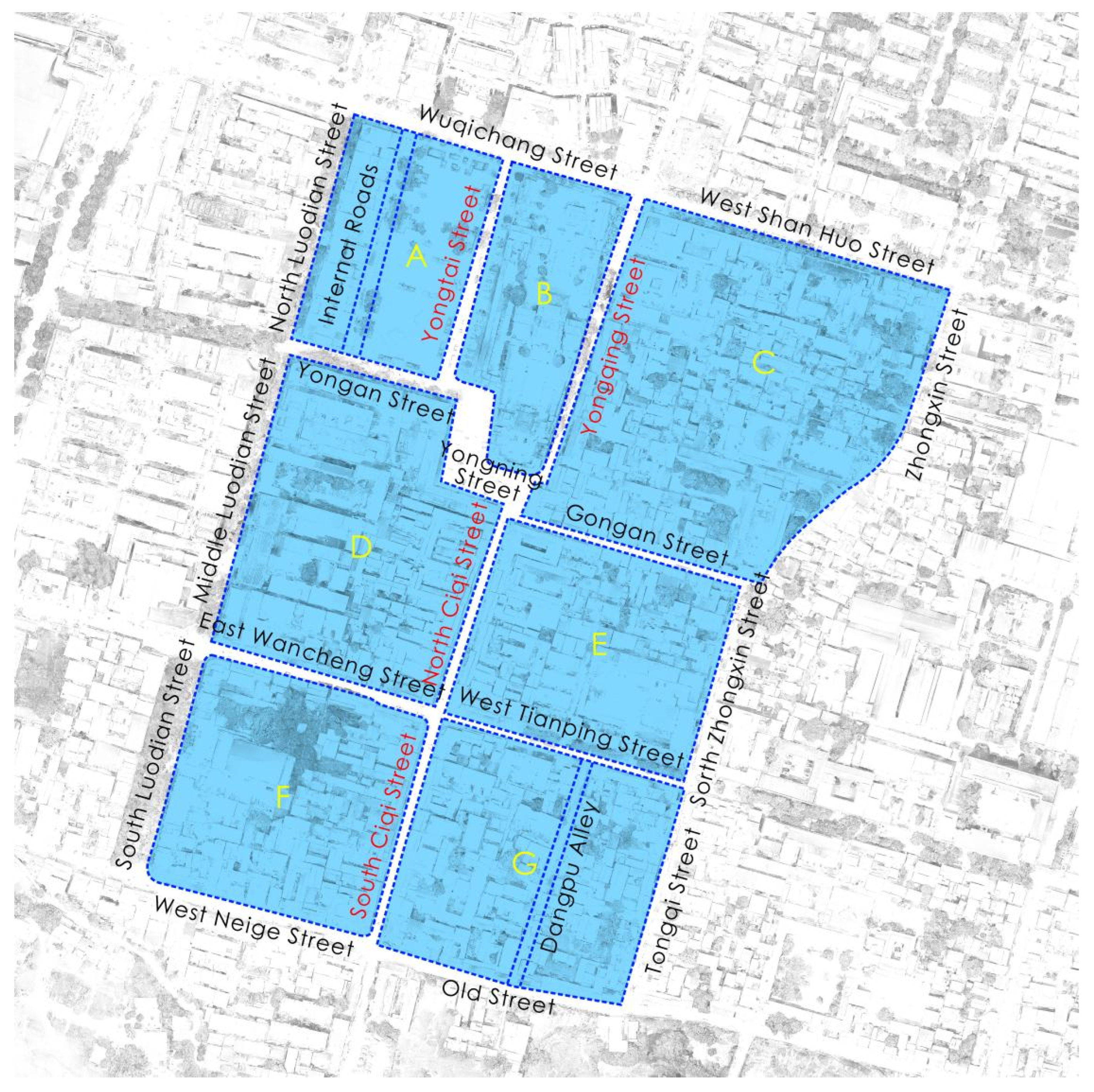
Figure 1. Study Area and Zoning.
Buildings 15 03502 g001
Figure 2. Technical approach.
Buildings 15 03502 g002
Figure 3. Building Height.
Buildings 15 03502 g003
Figure 4. Building Density.
Buildings 15 03502 g004
Figure 5. Floor Area Ratio.
Buildings 15 03502 g005
Figure 6. Fire Truck Accessibility.
Buildings 15 03502 g006
Figure 7. Building Quality.
Buildings 15 03502 g007
Figure 8. Road Surface Materials.
Buildings 15 03502 g008
Figure 9. Sunlight Exposure.
Buildings 15 03502 g009
Figure 10. Thermal Comfort.
Buildings 15 03502 g010
Figure 11. Intensity of Human Activity.
Buildings 15 03502 g011
Figure 12. Street Green View Ratio.
Buildings 15 03502 g012
Figure 13. Semantic Segmentation Results.
Buildings 15 03502 g013
Figure 14. 500 m Service Radius of Public Spaces (≥300 m2).
Buildings 15 03502 g014
Figure 15. 400 m Service Radius of Bus Stops.
Buildings 15 03502 g015
Figure 16. 400 m Service Radius of Public Restrooms.
Buildings 15 03502 g016
Figure 17. Distribution of Commercial and Leisure Service Facilities.
Buildings 15 03502 g017
Figure 18. Architectural Style.
Buildings 15 03502 g018
Figure 19. Current Function and Use of Historical and Cultural Heritage Buildings.
Buildings 15 03502 g019
Figure 20. Analysis of Health-Oriented Revitalization in Historic Blocks.
Buildings 15 03502 g020
Table 1. Health Assessment Framework.
Primary IndicatorSecondary IndicatorTertiary IndicatorEvaluation Criteria
Extremely UnhealthyRelatively UnhealthyGenerally HealthyRelatively HealthyExtremely Healthy
Block SafetyFire SafetyBuilding Heighth > 1815 < h ≤ 1812 < h ≤ 159 < h ≤ 123 < h ≤ 9
Building Densityx > 50%43% < x ≤ 50%30% < x ≤ 43%25% < x ≤ 30%x ≤ 25%
Floor Area Ratiox > 1.31.2 < x ≤ 1.31.1 < x ≤ 1.21.1 < x ≤ 1.0x ≤ 1.0
Fire Truck AccessibilityThe road width does not meet the fire truck access standardsAlthough the road width meets the standards, the presence of barriers at the intersection prevents direct access for fire trucks.Although the road width meets traffic requirements, persistent issues such as illegal parking and other obstructions interfere with access.While the road width meets traffic requirements, occasional issues such as illegal parking and other obstructions may interfere with access.Meets fire truck access standards, with no obstructions or interfering factors.
Residential SafetyBuilding QualityCompletely DamagedThe structure and exterior are in poor condition, with temporary constructions or significant damage and deterioration due to aging.The overall structure is largely intact, with some signs of aging on the exterior.The overall structure and exterior are well-maintained, with no need for repairs.The overall structure and exterior are well-maintained, and the building remains clean and hygienic.
Traffic SafetyRoad surface materialsThere is no hard paving, and the land is left exposed.There is hard paving, but it has suffered damage and has developed depressions.The hard paving is intact.The hard paving is intact and constructed with high-quality materials, such as asphalt.The hard paving is intact, with materials and design that reflect the distinctive characteristics of the historic town.
Block ComfortSunlight ExposureSunlight Duration0–1 h1–2 h2–3 h3–4 h≥4 h
Thermal ComfortUTCIThere is no season in which the area is free from thermal stress.One season experiences no thermal stress.Two seasons experience no thermal stress.Three seasons experience no thermal stress.All four seasons experience no thermal stress.
Block Ecology

Nature
Social EcologyIntensity of Human ActivityHigh level of human activity.Relatively high level of human activity.Moderate level of human activity.Relatively low level of human activityLow level of human activity.
Natural Ecology500 m Service Radius of Park Green Spacesx < 30%30% ≤ x < 40%40% ≤ x < 50%50% ≤ x < 60%x ≥ 60%
Street Green View Ratiox < 5%5% ≤ x < 15%15% ≤ x < 25%25% ≤ x < 35%x ≥ 35%
Block ConvenienceAccessibility of Public Services500 m Service Radius of Public Spaces (≥300 m2)x < 30%30% ≤ x < 40%40% ≤ x < 50%50% ≤ x < 60%x ≥ 60%
400 m Service Radius of Public Restroomsx < 40%40% ≤ x < 60%60% ≤ x < 80%80% ≤ x < 90%x ≥ 90%
400 m Service Radius of Bus Stopsx < 50%50% ≤ x < 60%60% ≤ x < 70%70% ≤ x < 90%x ≥ 90%
Convenience of Commercial and Leisure ServicesDistribution of Commercial and Leisure Service FacilitiesLow density of facility distributionRelatively low density of facility distributionModerate density of facility distributionRelatively high density of facility distributionHigh density of facility distribution
Block Cultural

Nature
Traditional StreetscapeBuildings’

Style
Highly incompatible with the traditional characterSomewhat incompatible with the traditional characterCompatible with the traditional character.Fully compatible with the traditional characterHistorical buildings and cultural heritage buildings
Revitalization and Adaptive Reuse of Cultural HeritageCurrent Function and Use of Historical and Cultural Heritage BuildingsDamaged, abandoned, or replaced by new constructionsIdle or used for storage of miscellaneous items and other ancillary functionsConventional residential buildingsUsed as guesthouses or shops, maintaining the character of the street while contributing to its economic valueTransformed into tourist attractions or museums, fully realizing their cultural value
Table 2. Sources of Evaluation for Each Indicator.
Primary IndicatorSecondary IndicatorTertiary IndicatorSource of Evaluation
Block SafetyFire SafetyBuilding HeightField Survey, GIS Analysis
Building DensityUniform Standard for Design of Civil Buildings [33]
Floor Area Ratio
Fire Truck AccessibilityField Survey
Residential SafetyBuilding QualityField Investigation, with Reference to the Historical and Cultural Heritage Protection Plan for Shedian Town, Sheqi County, Nanyang City (2016–2030)
Traffic SafetyRoad surface materialsField Survey
Block ComfortSunlight ExposureSunlight DurationBased on the Project code for residential building and Simulation Analysis [34]
Thermal ComfortUTCIAdapted from the UTCI Evaluation Standard
Block Ecology NatureSocial EcologyIntensity of Human ActivityBaidu Heatmap
Natural Ecology500 m Service Radius of Park Green SpacesBased on the Assessment standard for green eco-district [35]
Street Green View RatioRelated Research [36]
Block ConvenienceAccessibility of Public Services500 m Service Radius of Public Spaces (≥300 m2)Based on the Assessment standard for green eco-district [35]
400 m Service Radius of Public RestroomsBased on the Standard for planning of urban environment sanitation facilities [37]
400 m Service Radius of Bus StopsBased on the Assessment standard for green eco-district [35]
Convenience of Commercial and Leisure ServicesDistribution of Commercial and Leisure Service FacilitiesKernel Density Analysis
Block Cultural NatureTraditional StreetscapeArchitectural StyleField Investigation and the Historical and Cultural Heritage Protection Plan for Shedian Town, Sheqi County, Nanyang City (2016–2030)
Revitalization and Adaptive Reuse of Cultural HeritageCurrent Function and Use of Historical and Cultural Heritage Buildings
Table 3. Correspondence Between UTCI Values and Human Thermal Perception.
UTCI ValueHuman Comfort Perception
UTCI < −40Severe Cold Stress
−40 ≤ UTCI < −27Strong Cold Stress
−27 ≤ UTCI < −13Average Cold Stress
−13 ≤ UTCI < 0Moderate Cold Stress
0 ≤ UTCI < 9Mild Cold Stress
9 ≤ UTCI < 26No Thermal Stress
26 ≤ UTCI < 28Mild Heat Stress
28 ≤ UTCI < 32Moderate Heat Stress
32 ≤ UTCI < 38Average Heat Stress
38 ≤ UTCI < 46Strong Heat Stress
UTCI > 46Severe Heat Stress
Disclaimer/Publisher’s Note: The statements, opinions and data contained in all publications are solely those of the individual author(s) and contributor(s) and not of MDPI and/or the editor(s). MDPI and/or the editor(s) disclaim responsibility for any injury to people or property resulting from any ideas, methods, instructions or products referred to in the content.