
Machine Learning in the Design Decision-Making of Traditional Garden Space Renewal: A Case Study of the Classical Gardens of Jiangnan


Abstract
1. Introduction
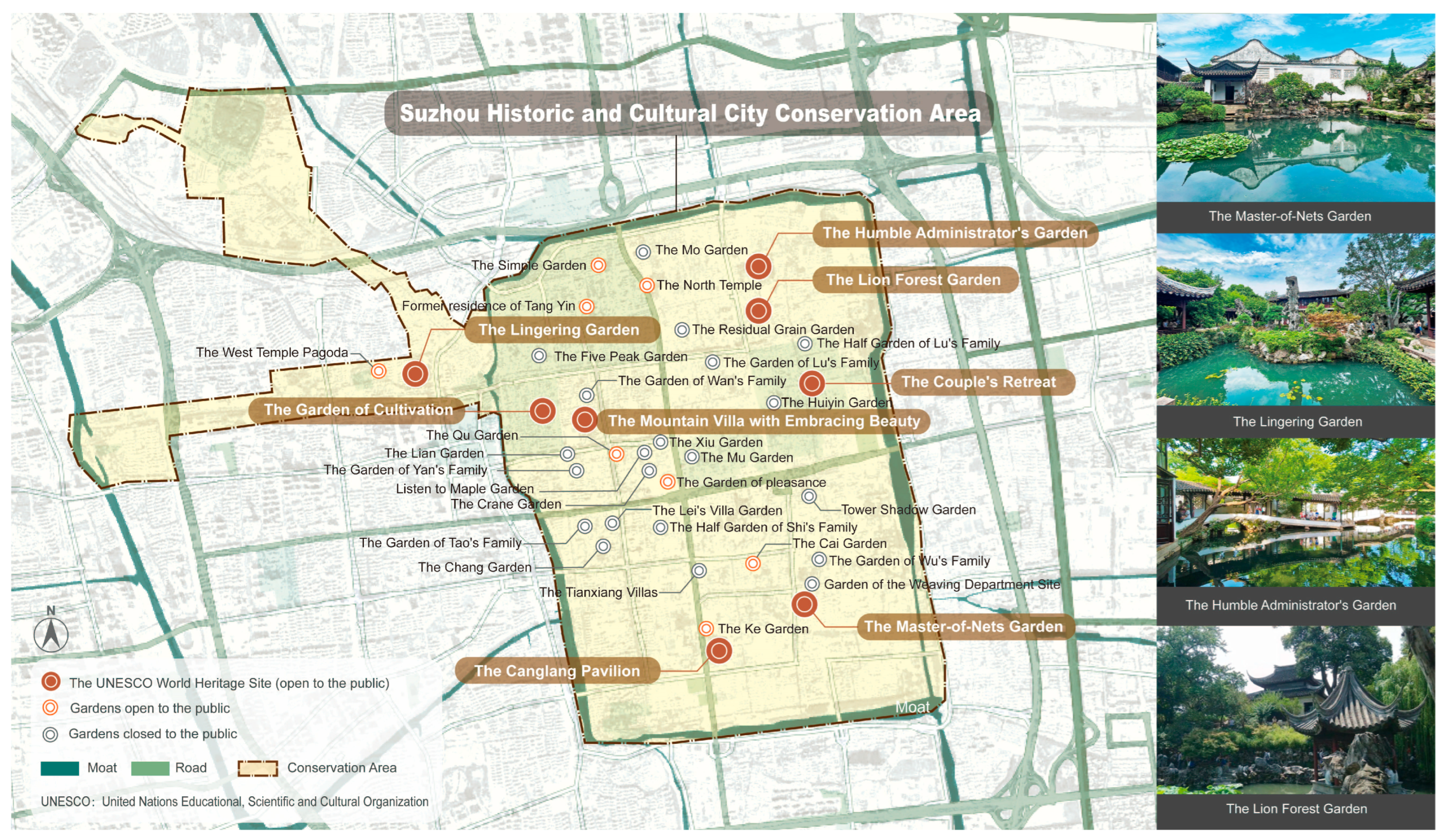
1.1. Research Background
1.2. Literature Review
1.3. Problem Statement and Objectives
- (1)
- Rapid generation of typologically diverse schemes adhering to spatial characteristics;
- (2)
- Preservation of landscape features at fine-grained heritage spatial scales;
- (3)
- Quantitative evaluation of spatial element compositional ratios.
- (1)
- What types of landscape spaces exist in traditional Jiangnan gardens?
- (2)
- What are the specific methods and processes of CGAN technology in the generation of traditional landscape spaces?
- (3)
- How accurate are the data training process and test results?
- (4)
- Compared with the traditional design process, what advantages does the process of generating floor plans with CGAN have in design decision-making?
- (5)
- Can multiple schemes be output to meet the decision-makers’ needs for scheme comparison and selection?
- (6)
- Does the utilization rate of the generated planar space meet the normative requirements of the design decision?
2. Materials and Methods
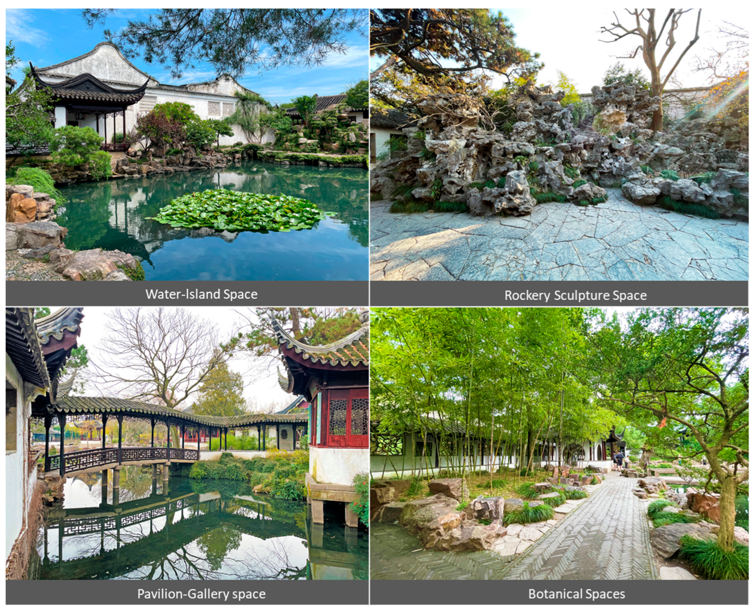
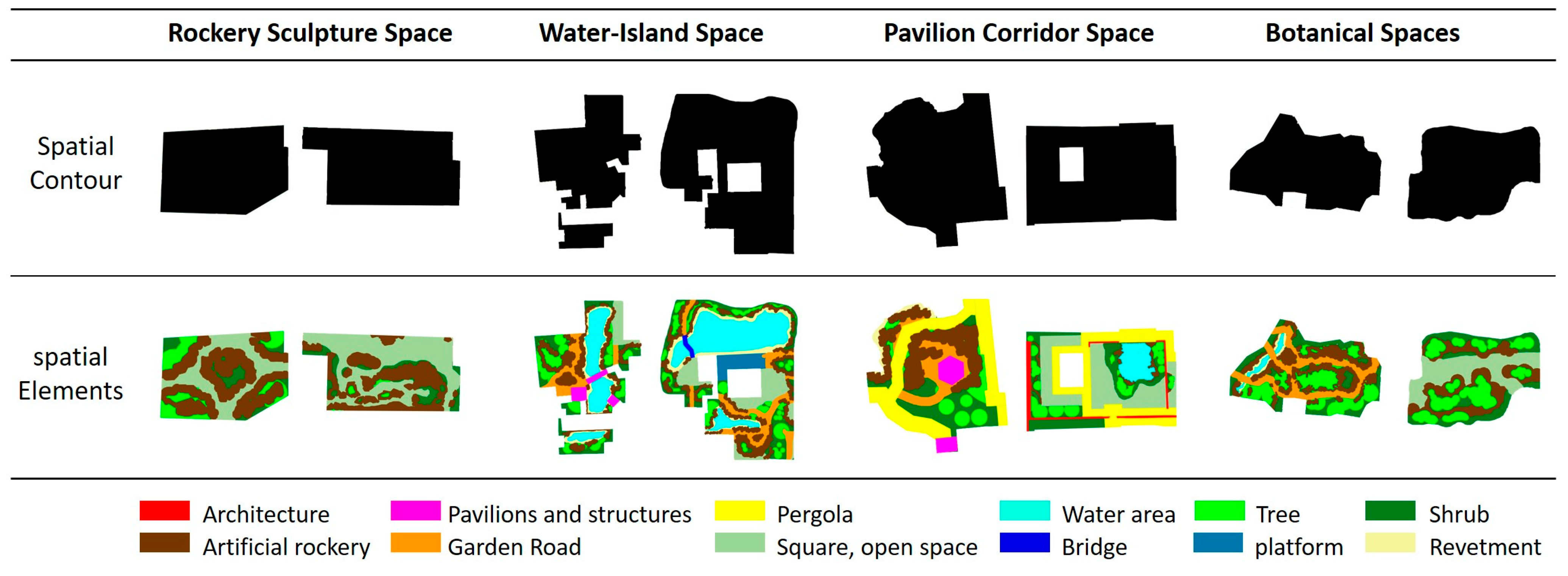
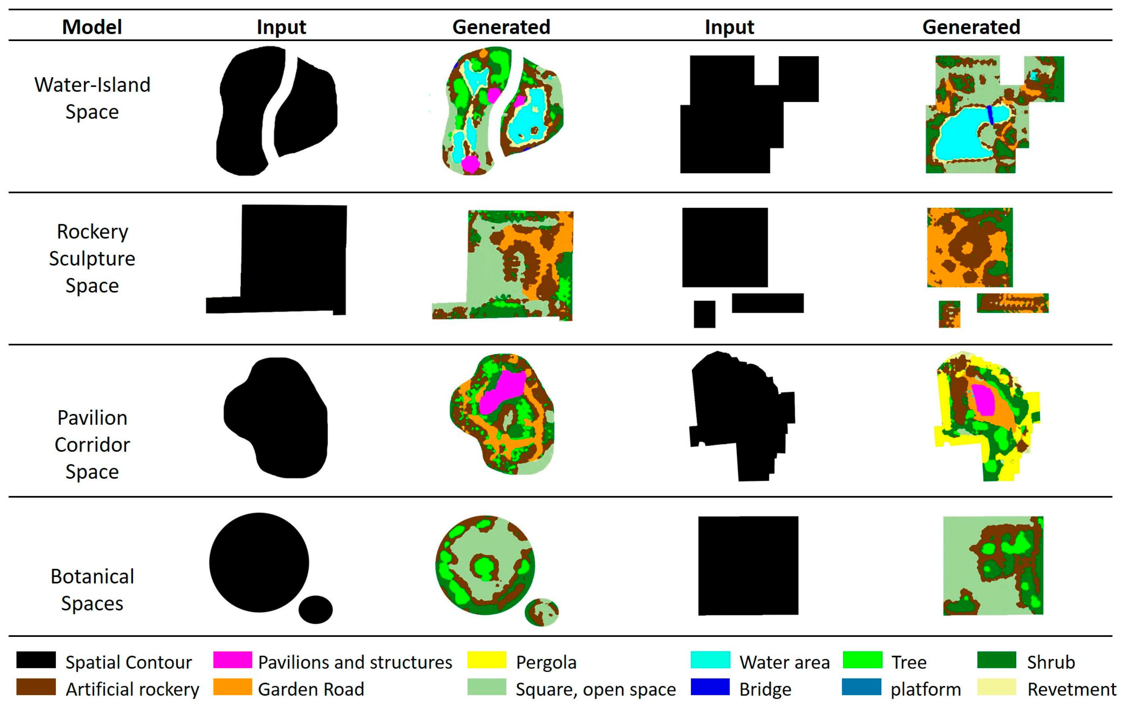
2.1. The Characteristics of Garden Space
- (1)
- Water-Island Space
- (2)
- Rockery Sculpture Space
- (3)
- Pavilion Corridor Space
- (4)
- Botanical Spaces
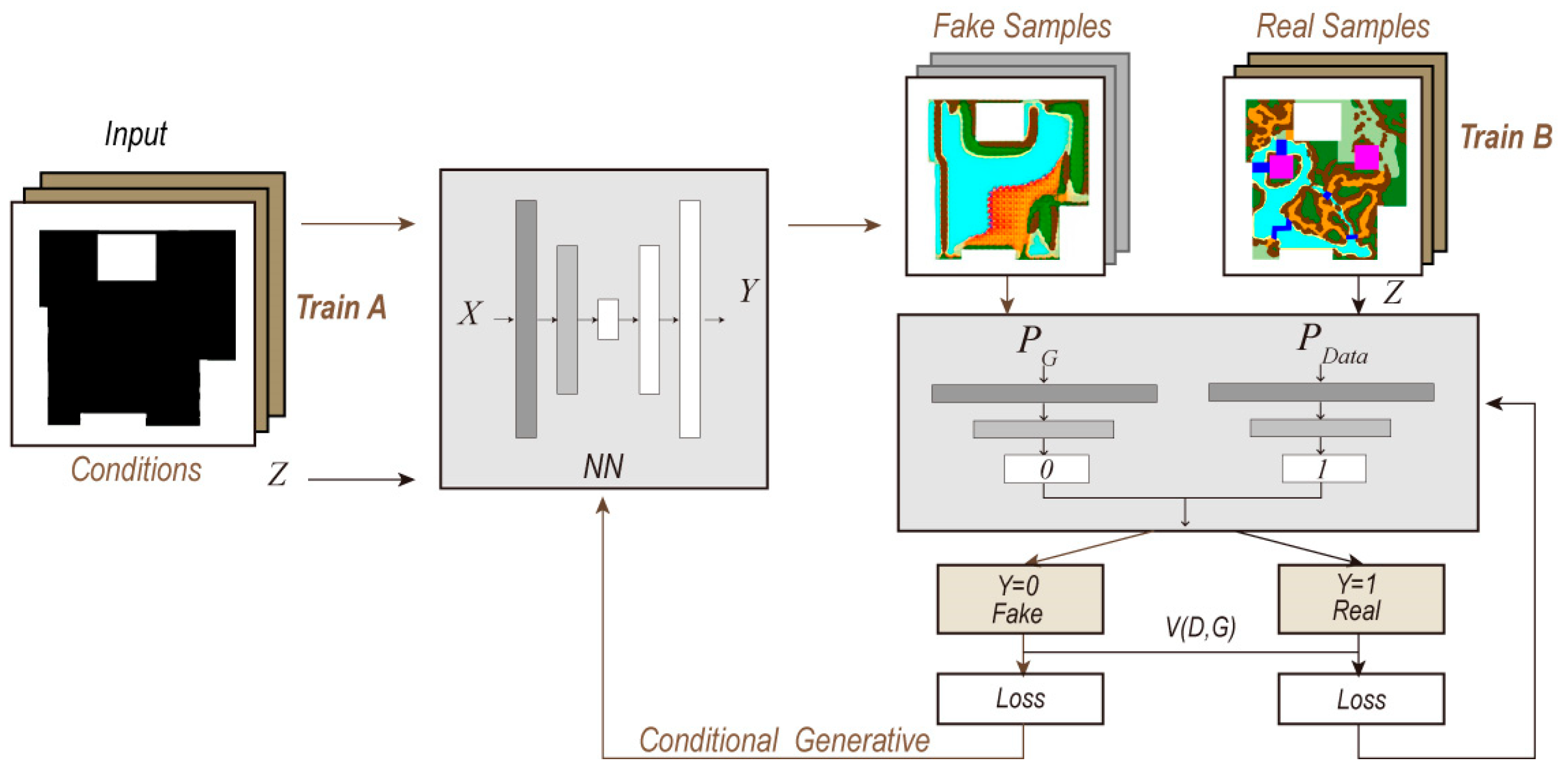
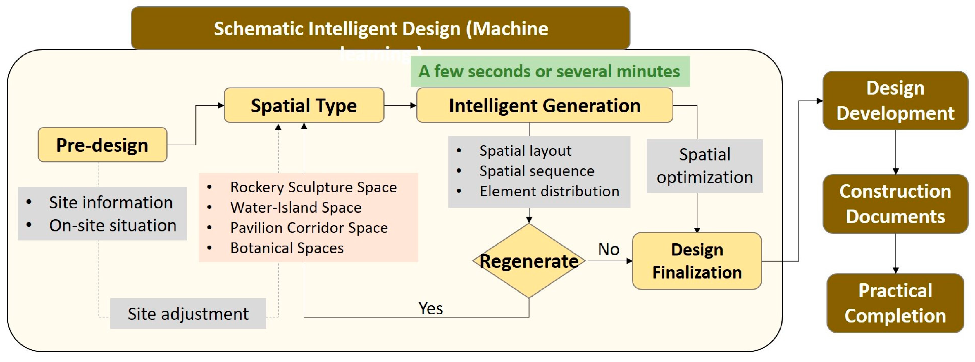
2.2. CGAN Method
2.2.1. Framework and Principles
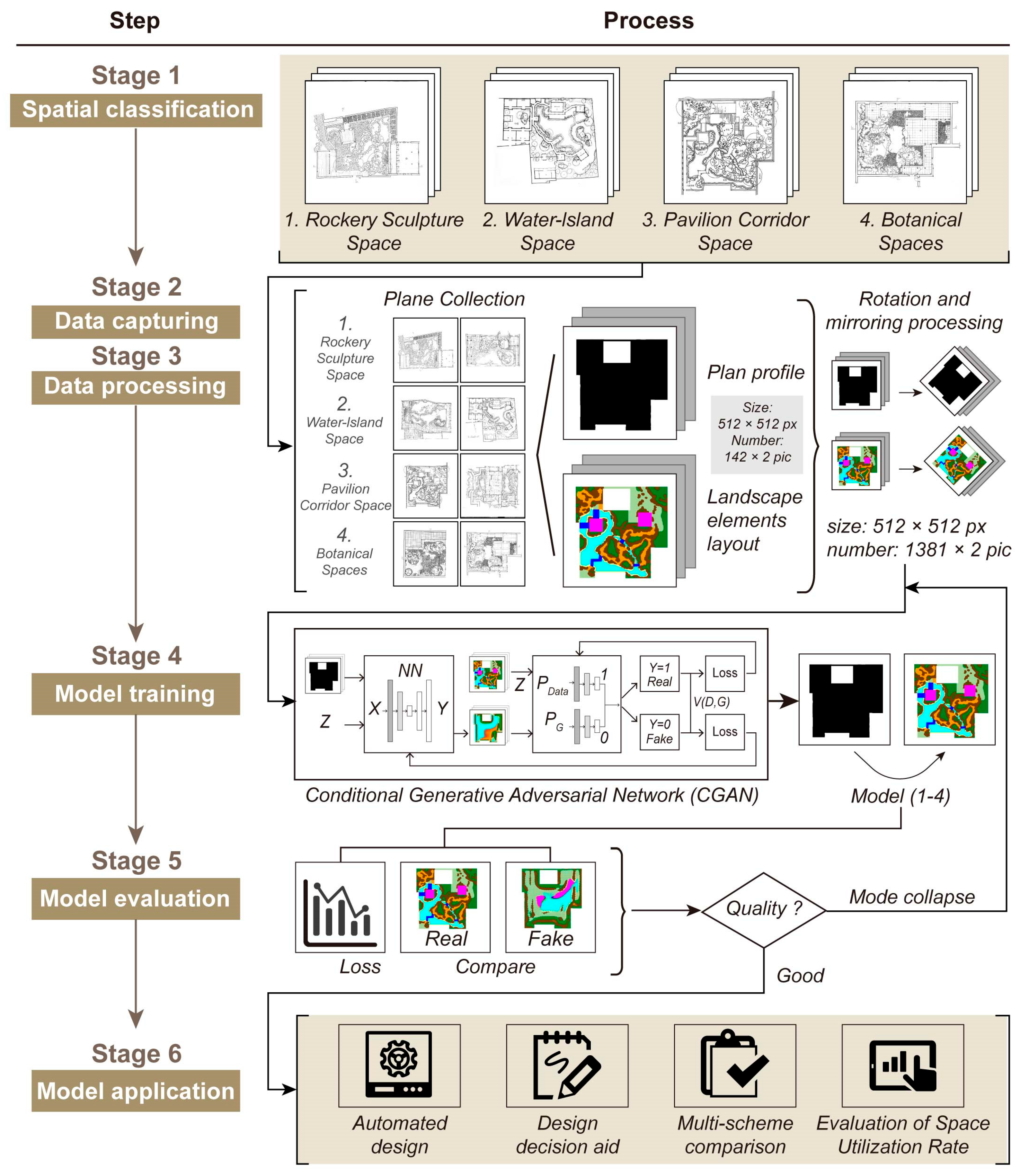
2.2.2. Research Methods and Procedures
- (1)
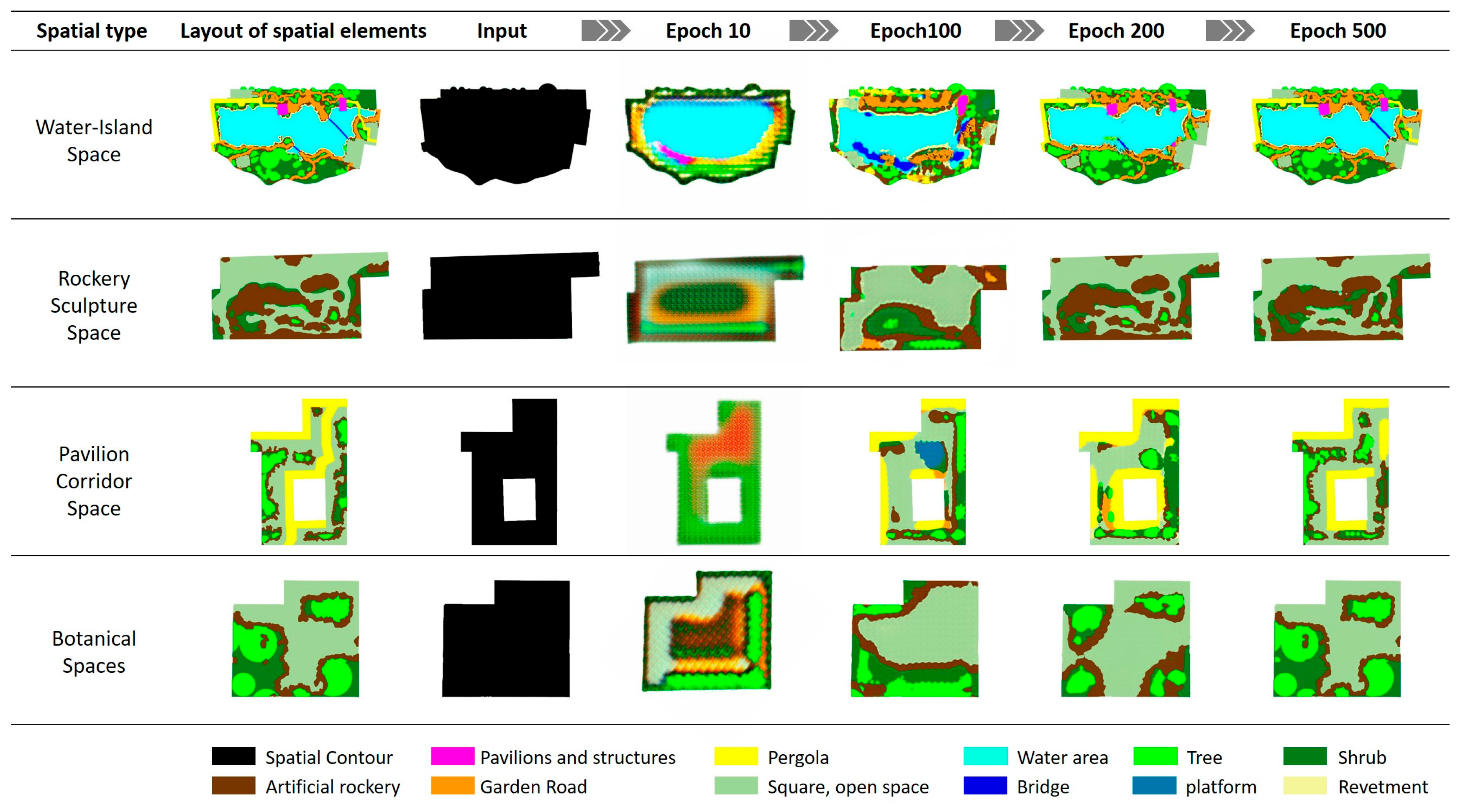
- Data classification: Spatial type division is carried out in accordance with traditional landscape features. According to the characteristics of landscape space elements in traditional Jiangnan classical gardens, their spatial types are classified as: rockery sculpture space, water-island space, pavilion corridor space, and botanical spaces.
- (2)
- Data collection: At the same scale, spatial floor plans with corresponding features are extracted from the original floor plans of classical gardens according to different types of landscapes as the basic samples for training.
- (3)
- Data processing: Targeted processing is conducted based on the characteristics of the samples. Firstly, the sample size is increased. The sample size of the landscape space is limited, and it is necessary to increase the training sample size through technical means. Secondly, the contour map is drawn, which will serve as an input for the generation condition in the CGAN learning process. Secondly, the landscape space elements are classified and colored to enable the machine to effectively recognize the content and features of the drawing during the learning process. Finally, the size of the training images is unified to improve the efficiency of training.
- (4)
- Model training: Paired training samples are placed in the CGAN training framework for machine learning. The CGAN model framework requires paired samples for training. The “contour atlas” and the corresponding “spatial element atlas” obtained above are paired sample sets. Each of the contour maps corresponds to a spatial element map for paired training. The purpose is to obtain the spatial meta-layout primitives under contour control; that is, to input one contour map and derive a corresponding spatial element layout map scheme.
- (5)
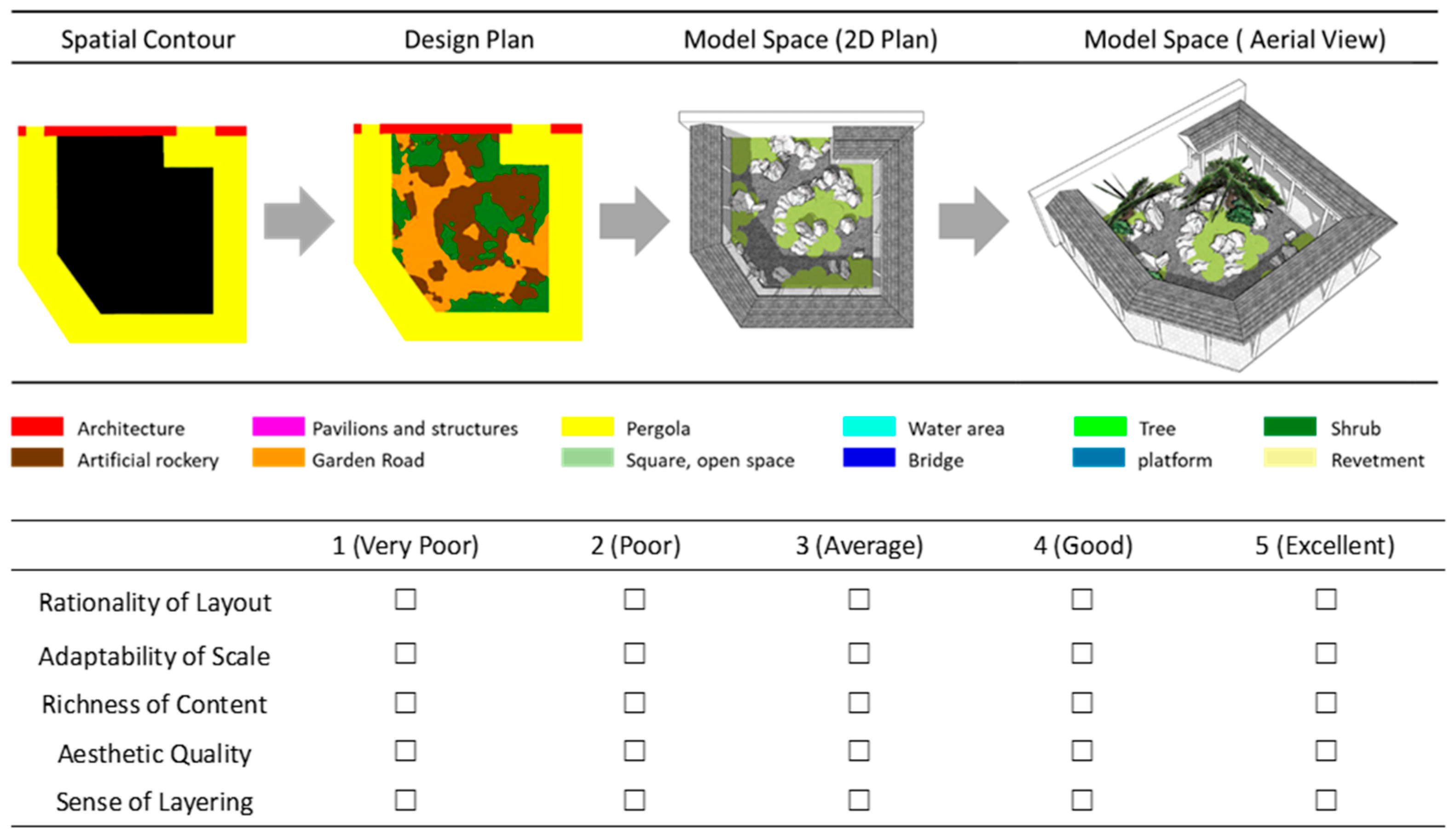
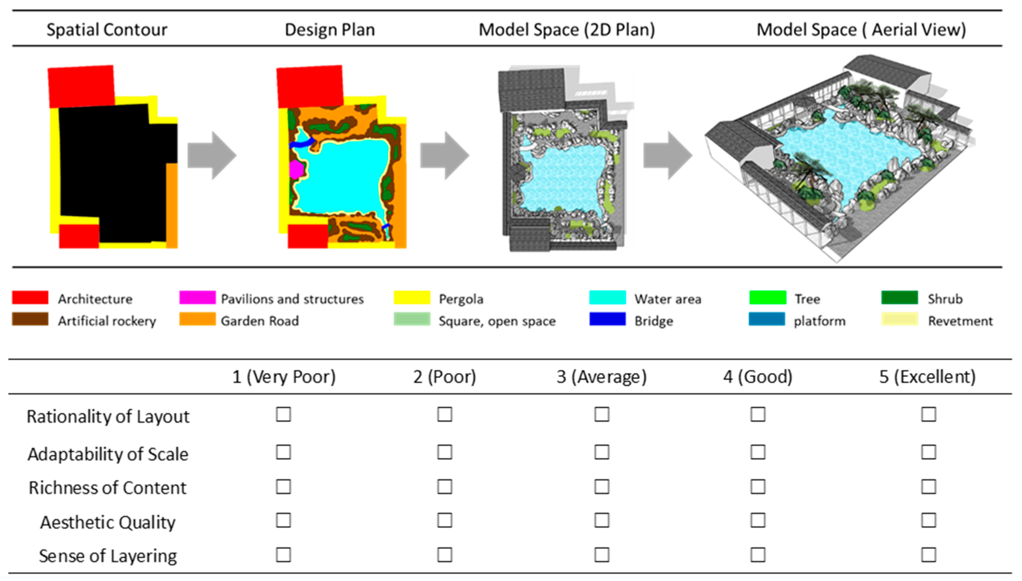
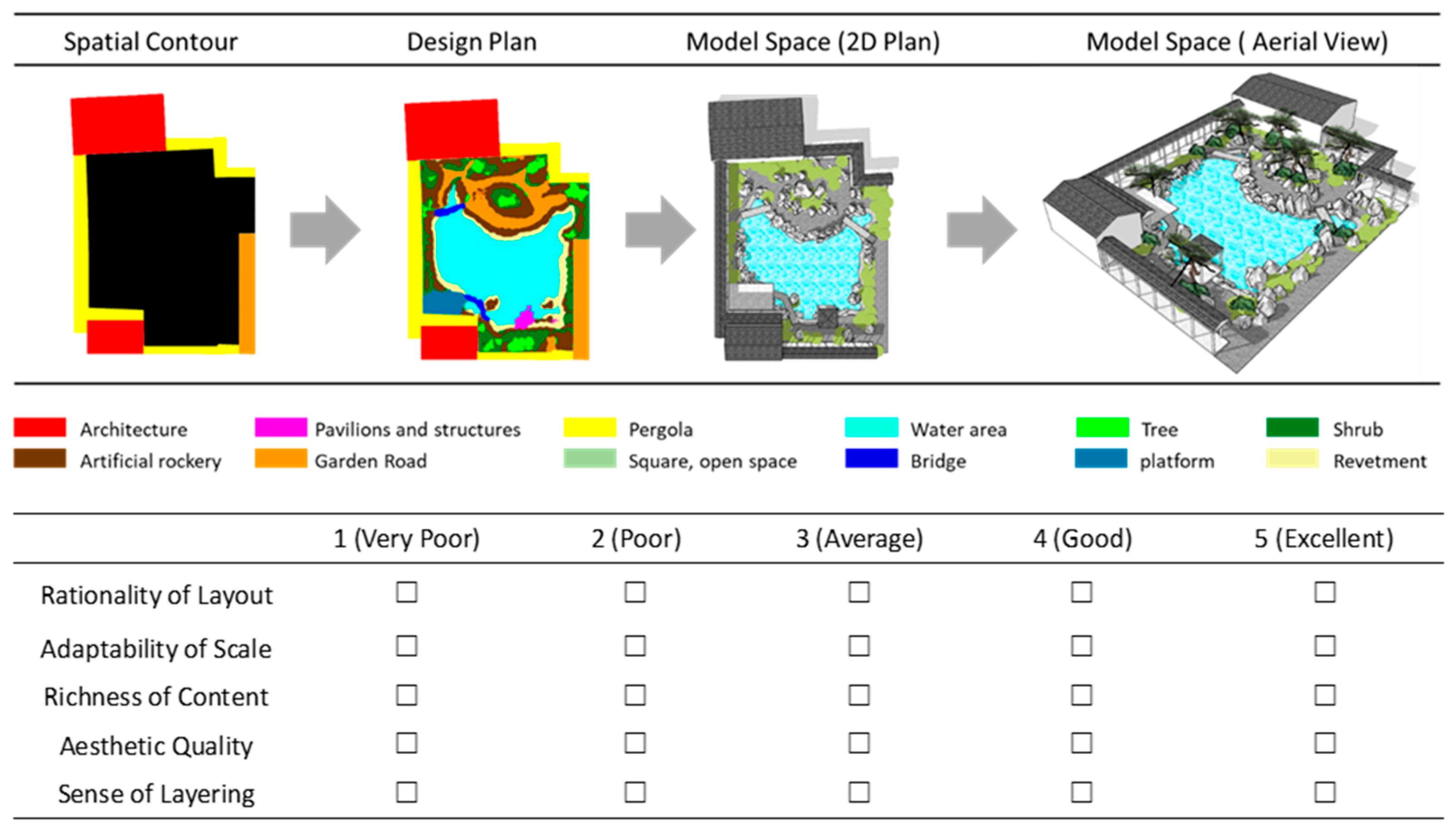
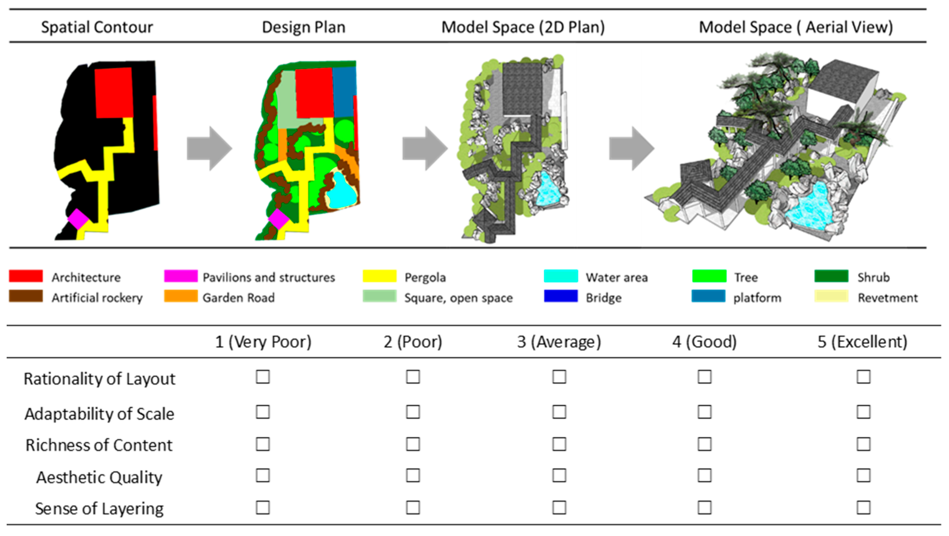
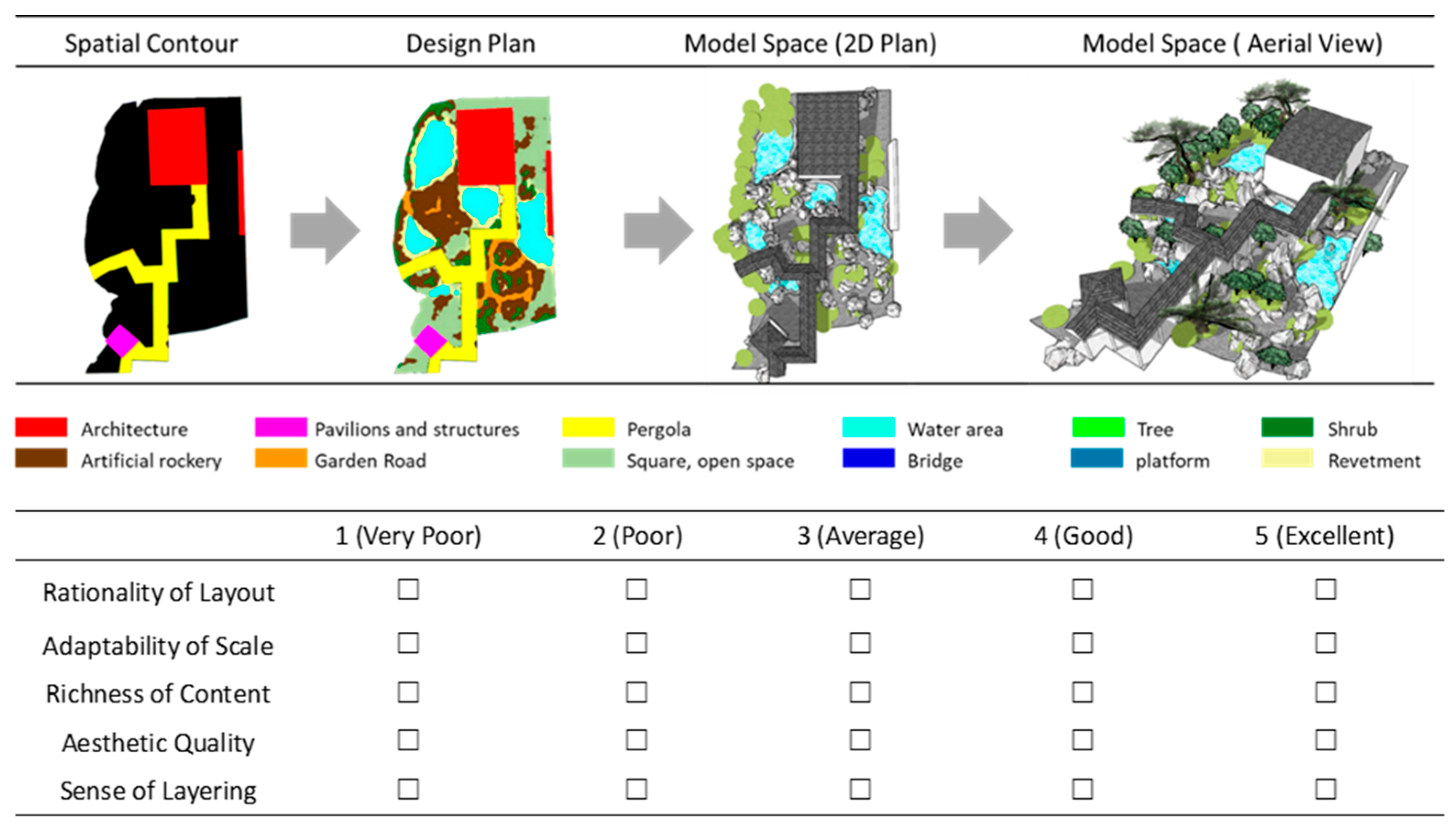
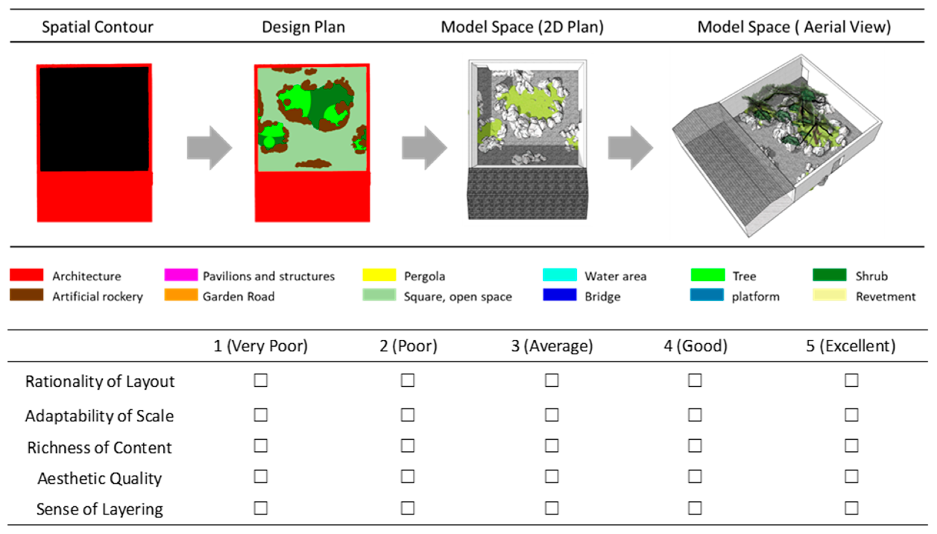
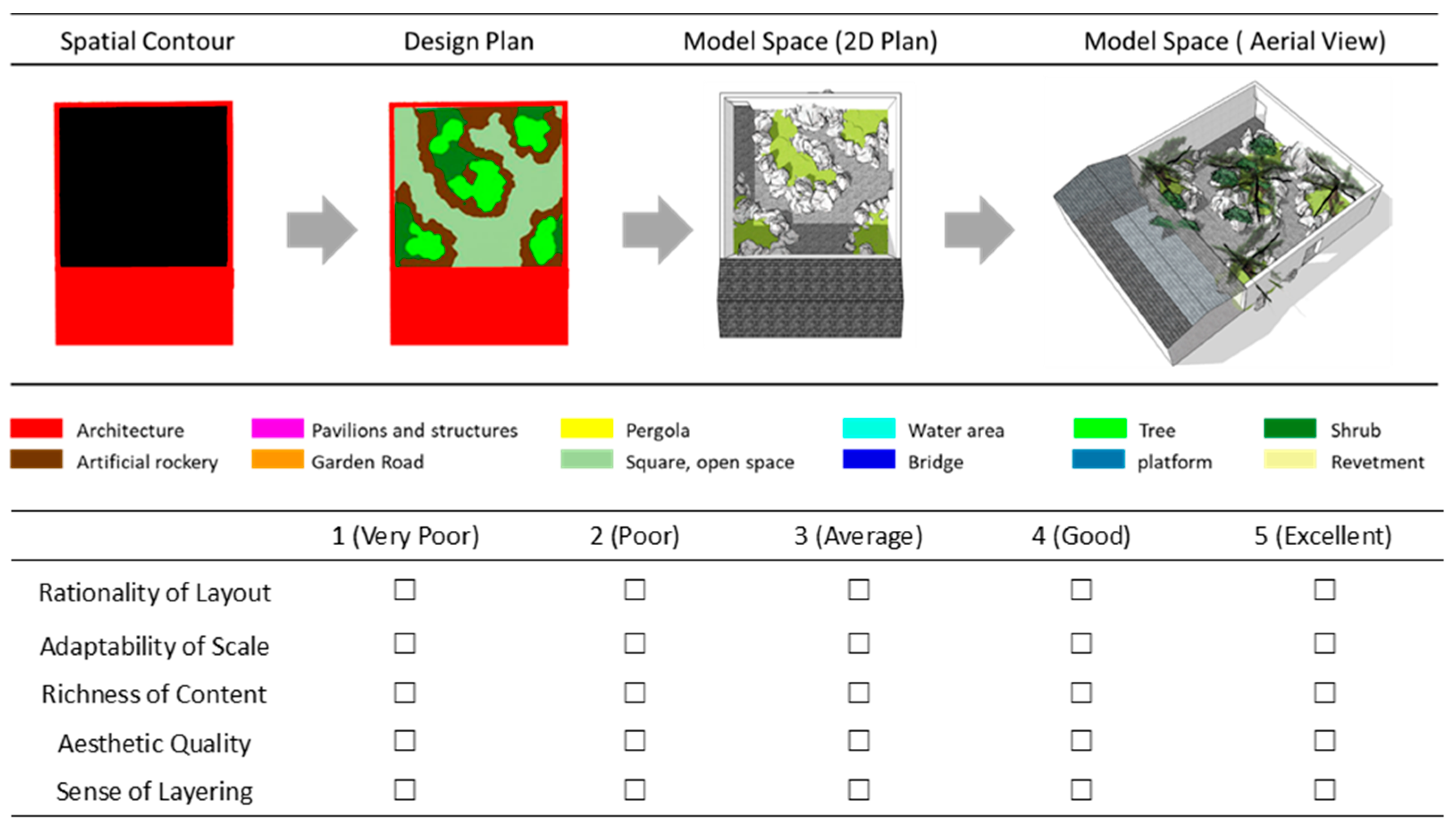
- Model Evaluation: To verify the training effect of the model, this study conducted evaluations in three aspects. First, the loss value of CGAN was observed in each iteration, and test images were generated during the iteration process. Secondly, the generated test samples were compared with the original samples to evaluate whether there was any deviation in the effect of the generated samples. Finally, a professional satisfaction survey was conducted between the samples generated by the test and the original samples to obtain a professional assessment of the spatial effect. After the above three rounds of evaluation, if the effect was not satisfactory, it was necessary to adopt cyclic optimization training, repeatedly adjusting parameters, increasing the number of iterations, and employing other methods to improve the effect of model training. If the training effect was satisfactory, the next application stage could be entered.
- (6)
- Model Application: The results generated through the training of this process method are applied in actual design as an auxiliary tool for the generation of garden landscape space.
2.3. Data Collection and Processing
- (1)
- Area selection: Between 200 and 1000 m2, to control the scale rationality of spatial generation. Excluded were instances like the 8 m2 floor plan courtyard in the Lingering Garden.
- (2)
- Scope definition: It must possess relatively clear spatial boundaries; for example, the scope of architectural spaces is defined by building boundaries, and plant spaces are defined by plant courtyards.
- (3)
- Distinct element characteristics: Each spatial type must contain identifiable landscape elements. For instance, a water-island space must include water bodies, and a rockery space must contain rocks. Excluded were spaces dominated by a single element, such as a 200 m2 plant space filled solely with bamboo, or an area consisting entirely of water bodies without other landscape elements.
3. Model Training and Testing
3.1. Model Training Process
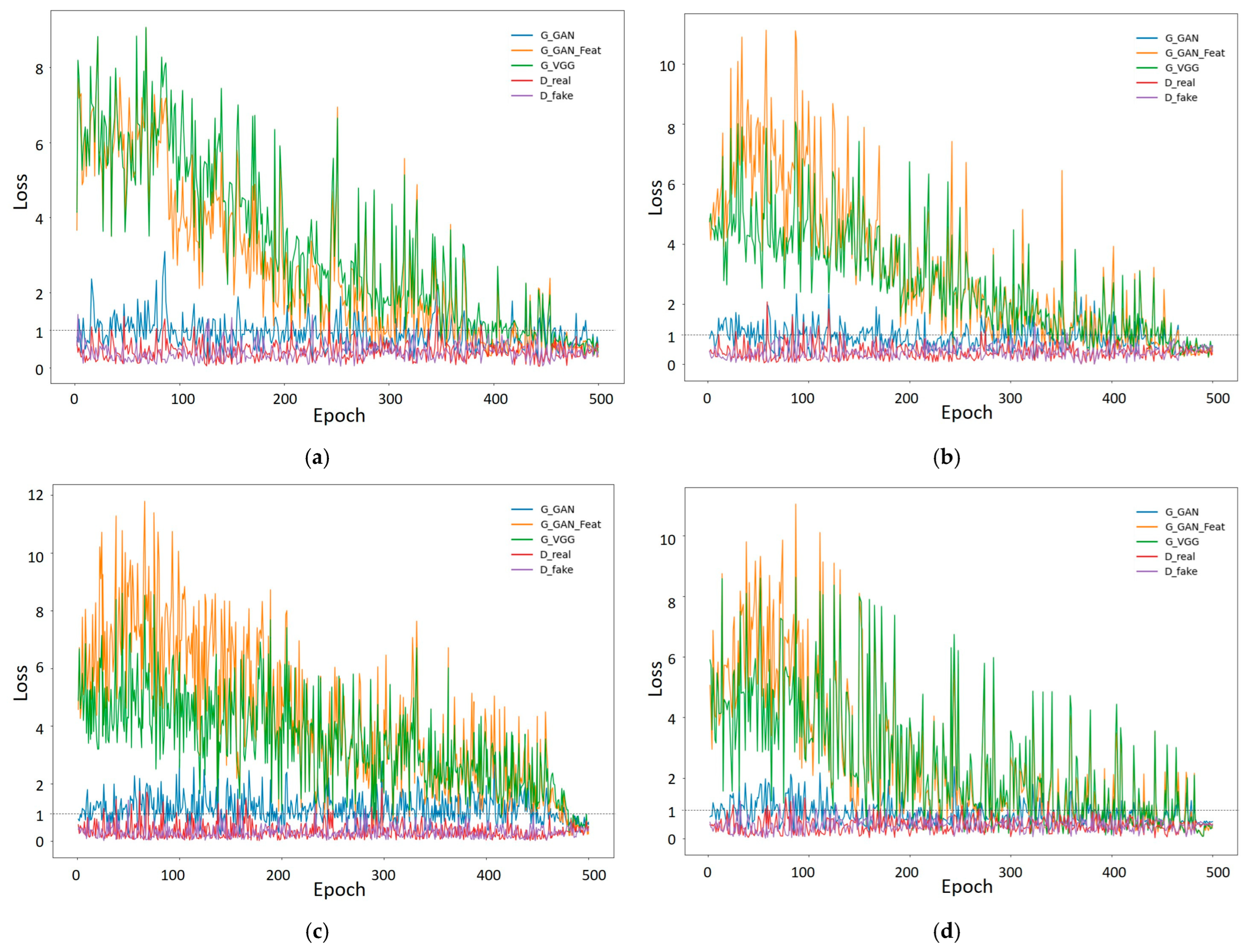
3.1.1. Loss Value Log Data
3.1.2. Accuracy of the Iterative Process Model
3.2. Model Accuracy Test and Comparison
3.3. Model Robustness Test
4. Discussion: Application in Design Decision-Making
4.1. Simplify the Decision-Making and Design Process of the Scheme
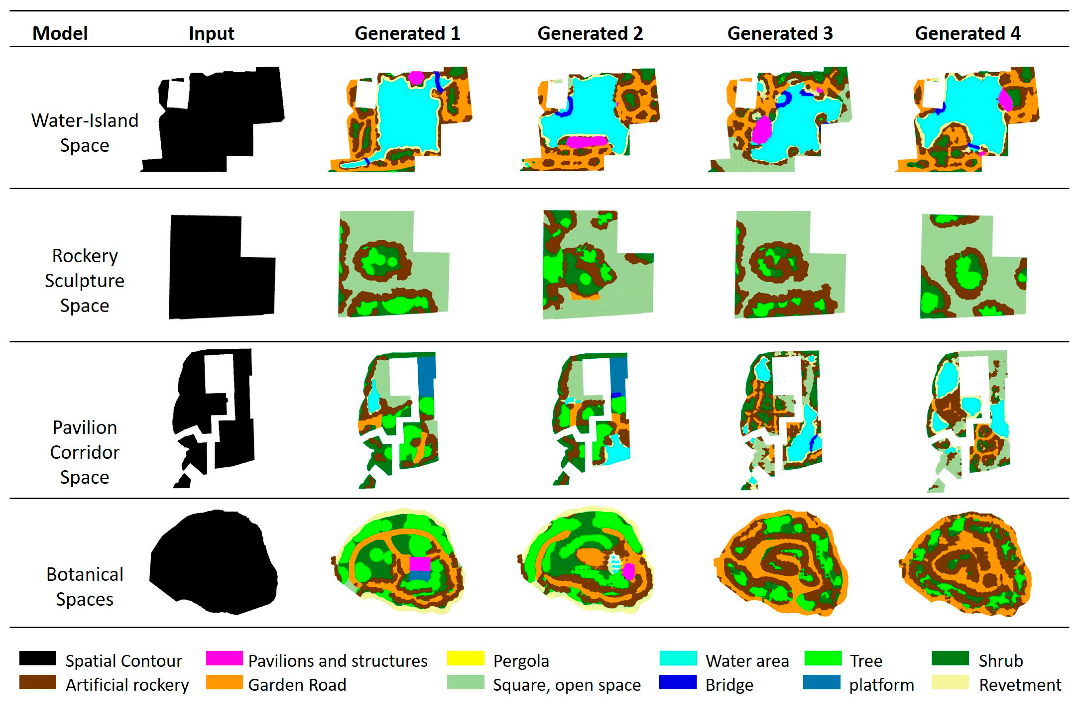
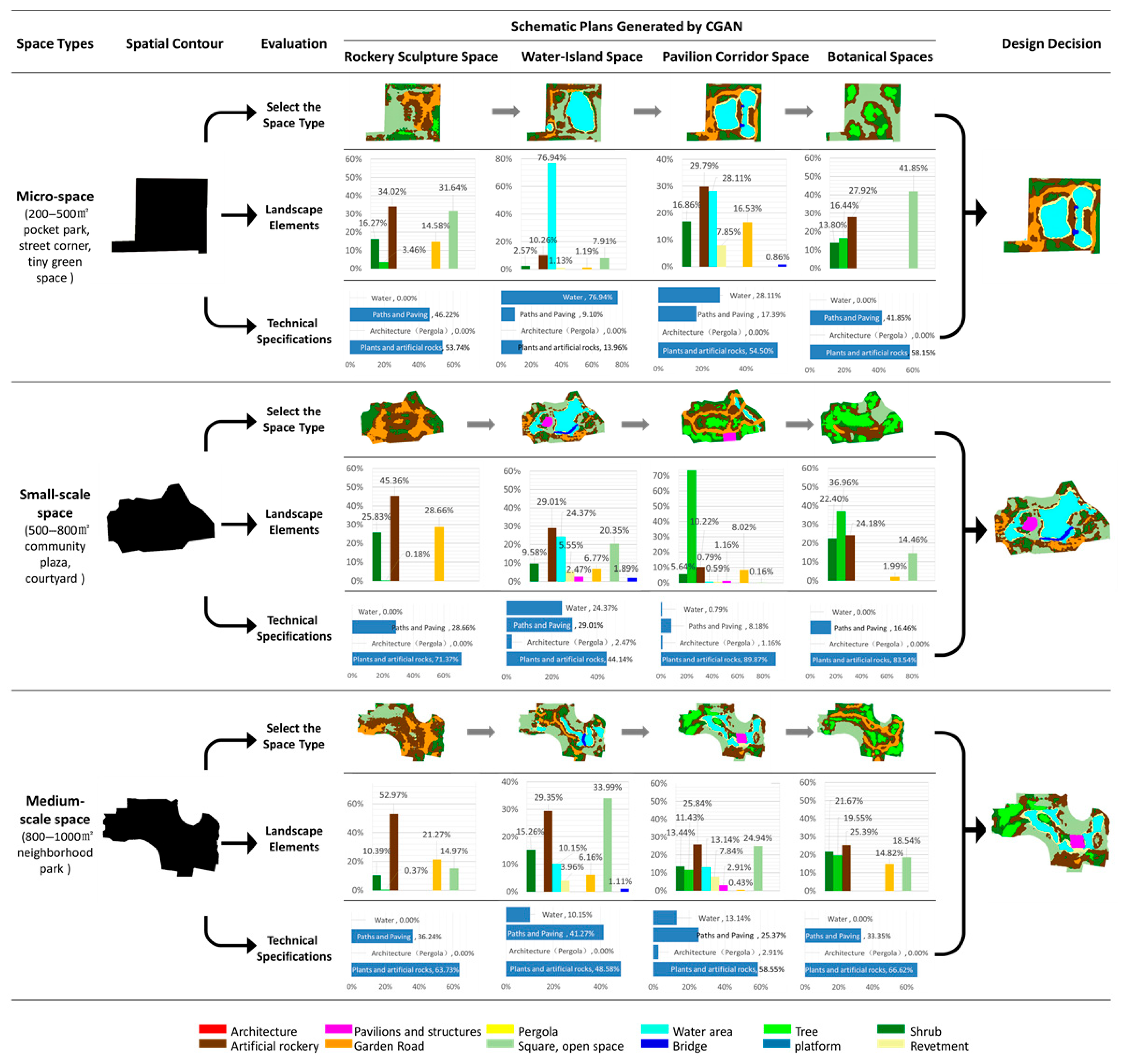
4.2. Multi-Scheme Comparison of the Planning Site
- (1)
- Different schemes are generated for comparison and selection at the same site.
- (2)
- Different venues generate different scheme comparisons.
4.3. Evaluation of Space Utilization Rate
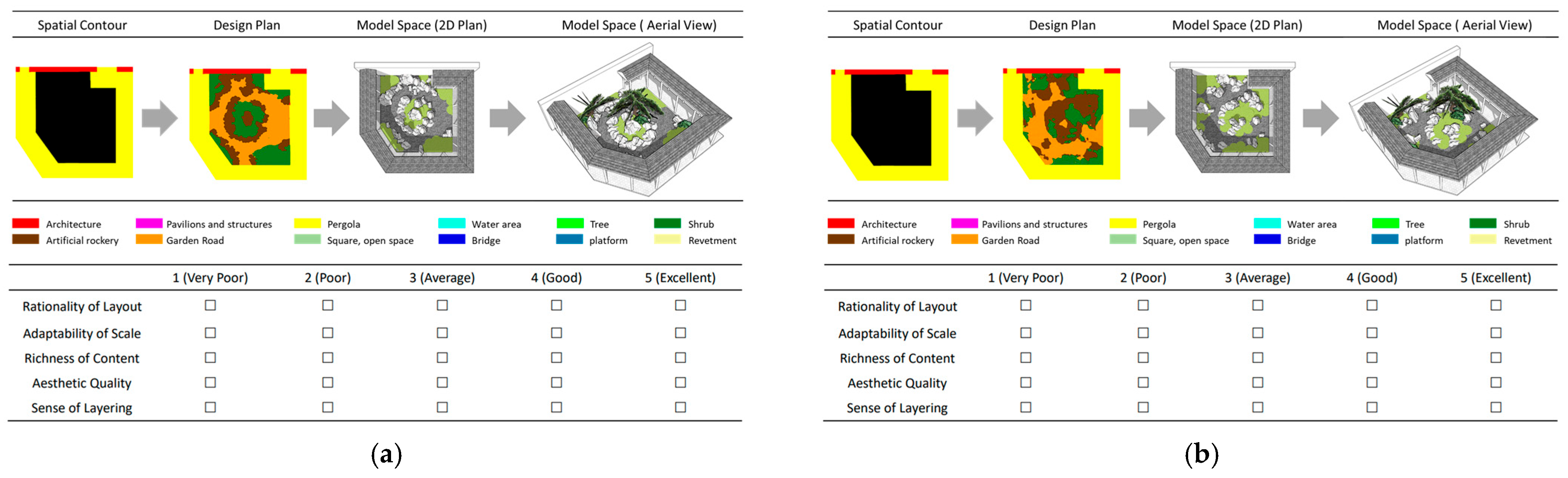
4.4. Satisfaction with the Generated Floor Plan
4.4.1. Investigation Methods and Verification
4.4.2. Analysis of Investigation Results
- (1)
- Overall satisfaction comparison
- (2)
- Analysis of performance in each dimension
5. Conclusions
- (1)
- The CGAN model can effectively capture the key layout characteristics of the garden space. Four different types of landscape spaces, namely, rockery sculpture space, water-island space, pavilion gallery space, and botanical spaces, can be generated according to the characteristics of the spatial environment.
- (2)
- This model can be applied to projects with space sizes ranging from 200 to 1000 square meters. The plans generated by CGAN can be applied in the renewal of micro and small spaces in urban historic conservation blocks.
- (3)
- After 500 epochs of training, the CGAN model can accurately learn the organizational rules of garden spaces, and the average accuracy rate of the generated planar schemes reached 91.08%.
- (4)
- The efficiency of the scheme generation was significantly improved. Compared with traditional design, which relies on experience and takes 1 to 3 months, 30 to 50 floor plans can be generated within 3 to 10 s on the same site. This has greatly improved the design efficiency.
- (5)
- CGAN can provide multiple scheme comparisons for decision-making in urban historic space renewal, helping managers to select the optimal solution in a short period of time.
- (6)
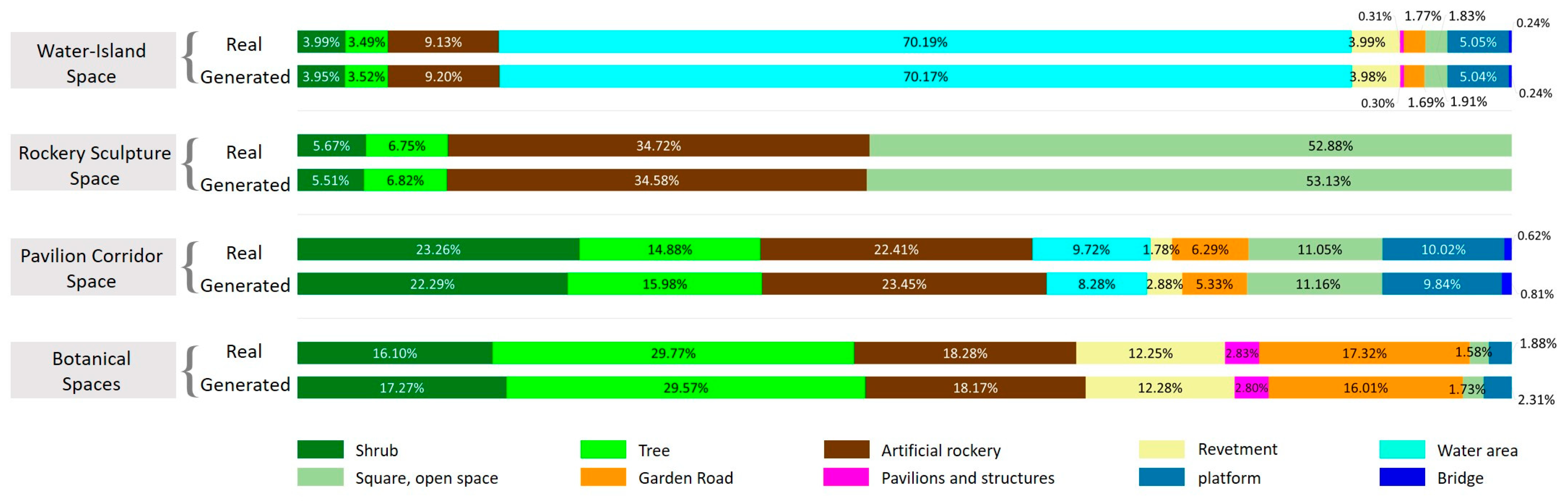
- The land-use proportions of 12 spatial elements can be quickly calculated based on the color of the element annotations. From this, the design specifications can be referred to for a quantitative assessment of the generated space utilization rate. Among the generated floor plans, the proportion of landscape greening basically met the specification requirements (>65%).
- (7)
- The floor plan generated by CGAN was slightly higher than the original floor plan in terms of the overall average satisfaction. The average satisfaction with the CGAN scheme (3.879) was higher than with the authentic garden space (3.863).
- (1)
- The detailed processing ability of the model needs to be improved to generate clear and realistic image results.
- (2)
- The model still faces certain challenges when dealing with the planar contours of curved surfaces and requires further improvement and optimization.
- (3)
- There is room for improvement in the clarity and cleanliness of the generated images.
- (4)
- The layout logic of building and rockery spaces must be optimized, the content richness of botanical spaces enhanced, and CGAN’s advantages in water areas consolidated.
Supplementary Materials
Author Contributions
Funding
Data Availability Statement
Conflicts of Interest
Abbreviations
| CGAN | Conditional Generative Adversarial Network |
| GAN | Generative Adversarial Network |
Appendix A
Appendix B
Appendix C
Appendix C.1

Appendix C.2

| Types | Evaluation | Mean | Std. Deviation |
|---|---|---|---|
| 1. Rockery sculpture space (A) | Rationality of Layout | 3.78 | 1.046 |
| Adaptability of Scale | 4.07 | 0.946 | |
| Richness of Content | 3.99 | 0.968 | |
| Aesthetic Quality | 3.69 | 1.067 | |
| Sense of Layering | 3.89 | 1.010 | |
| 2. Rockery sculpture space (B) | Rationality of Layout | 3.62 | 1.084 |
| Adaptability of Scale | 3.89 | 1.033 | |
| Richness of Content | 3.82 | 1.033 | |
| Aesthetic Quality | 3.52 | 1.131 | |
| Sense of Layering | 3.72 | 1.108 | |
| 3. Water-island space (A) | Rationality of Layout | 3.92 | 1.000 |
| Adaptability of Scale | 4.18 | 0.905 | |
| Richness of Content | 4.10 | 0.923 | |
| Aesthetic Quality | 3.83 | 1.013 | |
| Sense of Layering | 4.00 | 1.003 | |
| 4. Water-island space (B) | Rationality of Layout | 4.02 | 0.946 |
| Adaptability of Scale | 4.20 | 0.903 | |
| Richness of Content | 4.14 | 0.903 | |
| Aesthetic Quality | 3.96 | 1.022 | |
| Sense of Layering | 4.09 | 0.938 | |
| 5. Pavilion corridor space (A) | Rationality of Layout | 3.86 | 1.008 |
| Adaptability of Scale | 4.12 | 0.916 | |
| Richness of Content | 4.05 | 0.950 | |
| Aesthetic Quality | 3.75 | 1.031 | |
| Sense of Layering | 3.95 | 0.965 | |
| 6. Pavilion corridor space (B) | Rationality of Layout | 4.00 | 0.978 |
| Adaptability of Scale | 4.20 | 0.871 | |
| Richness of Content | 4.13 | 1.006 | |
| Aesthetic Quality | 3.92 | 1.001 | |
| Sense of Layering | 4.07 | 0.973 | |
| 7. Botanical spaces (A) | Rationality of Layout | 3.56 | 1.156 |
| Adaptability of Scale | 3.76 | 1.162 | |
| Richness of Content | 3.69 | 1.167 | |
| Aesthetic Quality | 3.48 | 1.163 | |
| Sense of Layering | 3.61 | 1.132 | |
| 8. Botanical spaces (B) | Rationality of Layout | 3.58 | 1.160 |
| Adaptability of Scale | 3.83 | 1.097 | |
| Richness of Content | 3.73 | 1.137 | |
| Aesthetic Quality | 3.49 | 1.140 | |
| Sense of Layering | 3.67 | 1.125 |
References
- Wang, H.; Shen, Q.; Tang, B.S.; Lu, C.; Peng, Y.; Tang, L. A framework of decision-making factors and supporting information for facilitating sustainable site planning in urban renewal projects. Cities 2014, 40, 44–55. [Google Scholar] [CrossRef]
- Yang, H. A Treatise on the Garden of Jiangnan: A study on the Art of Chinese Classical Garden, 1st ed.; Springer Nature: Berlin/Heidelberg, Germany, 2022. [Google Scholar] [CrossRef]
- Li, T.; Pintong, S. A Study on Innovative Strategies for Spatial Renewal Design in the Context of Rapid Urbanization: A Case Study of Nanjing Menxi Area. Int. J. Sociol. Anthropol. Sci. Rev. 2025, 5, 471–480. [Google Scholar] [CrossRef]
- Huang, Y.; Yang, S. Machine Learning Model for Building Type Classification of Cultural Heritage Sites along Jiangnan Canal: A Comparative Study of Historical and Modern Images. Int. J. Des. Soc. 2024, 18, 77. [Google Scholar] [CrossRef]
- Zhang, R.; Zhao, Y.; Kong, J.; Cheng, C.; Liu, X.; Zhang, C. Intelligent recognition method of decorative openwork windows with sustainable application for Suzhou traditional private gardens in China. Sustainability 2021, 13, 8439. [Google Scholar] [CrossRef]
- Yan, L.; Chen, Y.; Zheng, L.; Zhang, Y. Application of computer vision technology in surface damage detection and analysis of shedthin tiles in China: A case study of the classical gardens of Suzhou. Herit. Sci. 2024, 12, 72. [Google Scholar] [CrossRef]
- Chen, X.; Yu, H.; Xiong, R.; Ye, Y. Construction of an analytical framework for spatial indicator of Chinese classical gardens based on Space Syntax and machine learning. Landsc. Archit. 2024, 31, 123–131. [Google Scholar] [CrossRef]
- Zeng, Q.; Xu, J.; Chen, J. The Modular Information Fusion Model of Landscape Based on Machine Learning Algorithm. In Proceedings of the 2021 3rd International Conference on Artificial Intelligence and Advanced Manufacture, Wuxi, China, 10–12 September 2021; pp. 1695–1698. [Google Scholar] [CrossRef]
- Yan, L.; Chen, Y.; Zheng, L.; Zhang, Y.; Liang, X.; Zhu, C. Intelligent Generation Method and Sustainable Application of Road Systems in Urban Green Spaces: Taking Jiangnan Gardens as an Example. Int. J. Environ. Res. Public Health 2023, 20, 3158. [Google Scholar] [CrossRef]
- Sun, C.; Jiang, Z.; Yu, B. How to interpret Jiangnan gardens: A study of the spatial layout of Jiangnan gardens from the perspective of fractal geometry. Herit. Sci. 2024, 12, 353. [Google Scholar] [CrossRef]
- Liu, Y.; Fang, C.; Yang, Z.; Wang, X.; Zhou, Z.; Deng, Q.; Liang, L. Exploration on machine learning layout generation of Chinese private garden in Southern Yangtze. In Proceedings of the 2021 DigitalFUTURES: The 3rd International Conference on Computational Design and Robotic Fabrication (CDRF 2021) 3; Springer: Singapore, 2021; pp. 35–44. [Google Scholar] [CrossRef]
- Chen, R.; Zhao, J.; Yao, X.; Jiang, S.; He, Y.; Bao, B.; Wang, C. Generative design of outdoor green spaces based on generative adversarial networks. Buildings 2023, 13, 1083. [Google Scholar] [CrossRef]
- Pan, X.; Lin, Q.; Ye, S.; Li, L.; Guo, L.; Harmon, B. Deep learning based approaches from semantic point clouds to semantic BIM models for heritage digital twin. Herit. Sci. 2024, 12, 65. [Google Scholar] [CrossRef]
- Cui, Y. Research on garden landscape reconstruction based on geographic information system under the background of deep learning. Acta Geophys. 2023, 71, 1491–1513. [Google Scholar] [CrossRef]
- Xing, Y.; Gan, W.; Chen, Q. Artificial intelligence in landscape architecture: A survey. Int. J. Mach. Learn. Cybern. 2025, 1–26. [Google Scholar] [CrossRef]
- Chen, X. Environmental landscape design and planning system based on computer vision and deep learning. J. Intell. Syst. 2023, 32, 20220092. [Google Scholar] [CrossRef]
- Tao, L. Machine Learning Based Landscape Garden Plan Analysis and Rendering Application. J. Inf. Sci. Eng. 2025, 41, 279–295. [Google Scholar] [CrossRef]
- Zhao, B.; Zheng, H.; Cheng, X. A Machine Learning Approach to Predict Site Selection from the Perspective of Vitality Improvement. Land 2023, 13, 2113. [Google Scholar] [CrossRef]
- Xu, L. Value Assessment and Renovation Design of Buildings in the Perspective of Urban Renewal: Case Studies in China and Italy. 2023. Available online: https://hdl.handle.net/11577/3474288 (accessed on 24 June 2025).
- Wu, T.; Lin, D.; Chen, Y.; Wu, J. Integrating Street View Images, Deep Learning, and sDNA for Evaluating University Campus Outdoor Public Spaces: A Focus on Restorative Benefits and Accessibility. Land 2025, 14, 610. [Google Scholar] [CrossRef]
- Ye, Y.; Zeng, W.; Shen, Q.; Zhang, X.; Lu, Y. The visual quality of streets: A human-centred continuous measurement based on machine learning algorithms and street view images. Environ. Plan. B Urban Anal. City Sci. 2019, 46, 1439–1457. [Google Scholar] [CrossRef]
- Yang, B.; Volkman, N.J. From traditional to contemporary: Revelations in Chinese garden and public space design. Urban Des. Int. 2010, 15, 208–220. [Google Scholar] [CrossRef]
- Gu, L. Trends in Chinese Garden-making: The Qianlong Emperor (1711–99) and Gardens of Jiangnan. Gard. Hist. 2018, 46, 184–195. [Google Scholar]
- Rinaldi, B.M. The Chinese Garden: Garden Types for Contemporary Landscape Architecture, 1st ed.; Walter de Gruyter: Berlin, Germany, 2012. [Google Scholar] [CrossRef]
- Zheng, J. Art and the shift in garden culture in the Jiangnan Area in China (16th–17th Century). Asian Cult. Hist. 2013, 5, 1. [Google Scholar] [CrossRef]
- Kai, G. Literati Gardens of the Jiangnan Region: Characters and Mutations, 1st ed.; Routledge: London, UK; New York, NY, USA, 2022; pp. 102–120. [Google Scholar] [CrossRef]
- Liu, K.; Wang, Y.; Yang, R.; Xian, Z.; Takeda, S.; Zhang, J.; Xing, S. Interpreting the space characteristics of everyday heritage gardens of Suzhou, China, through a space syntax approach. J. Asian Archit. Build. Eng. 2024, 1–26. [Google Scholar] [CrossRef]
- Mirza, M.; Osindero, S. Conditional generative adversarial nets. arXiv 2014, arXiv:1411.1784. [Google Scholar] [CrossRef]
- Dosovitskiy, A.; Beyer, L.; Kolesnikov, A.; Weissenborn, D.; Zhai, X.; Unterthiner, T.; Dehghani, M.; Minderer, M.; Heigold, G.; Gelly, S.; et al. An Image is Worth 16x16 Words: Transformers for Image Recognition at Scale. arXiv 2020, arXiv:2010.11929. [Google Scholar] [CrossRef]
- Gupta, K.; Achille, A.; Lazarow, J.; Davis, L.; Mahadevan, V.; Shrivastava, A. Layout Generation and Completion with Self-attention. arXiv 2021, arXiv:2006.14615. [Google Scholar] [CrossRef]
- Liu, B.; Zhu, Y.; Song, K.; Elgammal, A. Towards Faster and Stabilized GAN Training for High-fidelity Few-shot Image Synthesis. arXiv 2021, arXiv:2101.04775. [Google Scholar] [CrossRef]
- Zhang, H.; Sindagi, V.; Patel, V.M. Image de-raining using a conditional generative adversarial network. IEEE Trans. Circuits Syst. Video Technol. 2019, 30, 3943–3956. [Google Scholar] [CrossRef]
- Ding, X.; Wang, Y.; Xu, Z.; Welch, W.J.; Wang, Z.J. Ccgan: Continuous conditional generative adversarial networks for image generation. In Proceedings of the International Conference on Learning Representations, Virtual Event, Austria, 3–7 May 2021; Available online: https://openreview.net/pdf?id=PrzjugOsDeE (accessed on 6 July 2025).
- Yang, J.; Liu, J.; Xie, J.; Wang, C.; Ding, T. Conditional GAN and 2-D CNN for bearing fault diagnosis with small samples. IEEE Trans. Instrum. Meas. 2021, 70, 3525712. [Google Scholar] [CrossRef]
- Zhang, D.; Islam, M.M.; Lu, G. A review on automatic image annotation techniques. Pattern Recognit. 2012, 45, 346–362. [Google Scholar] [CrossRef]
- Abu-Srhan, A.; Abushariah, M.A.; Al-Kadi, O.S. The effect of loss function on conditional generative adversarial networks. J. King Saud Univ.-Comput. Inf. Sci. 2022, 34, 6977–6988. [Google Scholar] [CrossRef]
- Zheng, L.; Chen, Y.; Yan, L.; Zheng, J. The Impact of High-Density Urban Wind Environments on the Distribution of COVID-19 Based on Machine Learning: A Case Study of Macau. Buildings 2023, 13, 1711. [Google Scholar] [CrossRef]
- Wu, L.; Tian, F.; Xia, Y.; Fan, Y.; Qin, T.; Jian-Huang, L.; Liu, T.Y. Learning to teach with dynamic loss functions. In Proceedings of the Advances in Neural Information Processing Systems, Montréal, QC, Canada, 3–8 December 2018; p. 31. [Google Scholar] [CrossRef]
- Thekumparampil, K.K.; Khetan, A.; Lin, Z.; Oh, S. Robustness of conditional gans to noisy labels. In Proceedings of the Advances in Neural Information Processing Systems, Montréal, QC, Canada, 2–8 December 2018; p. 31. [Google Scholar] [CrossRef]
- GB 51192-2016; Ministry of Housing and Urban-Rural Development of the People’s Republic of China. Code for the Design of Public Park. China Building Industry Publishing: Beijing, China, 2016; p. 8.
- Shrestha, N. Factor analysis as a tool for survey analysis. Am. J. Appl. Math. Stat. 2021, 9, 4–11. [Google Scholar] [CrossRef]
- Everitt, B.; Dunn, G. Applied Multivariate Data Analysis; Arnold: London, UK, 2001; Volume 2. [Google Scholar] [CrossRef]
- Tabachnick, B.G.; Fidell, L.S.; Ullman, J.B. Using Multivariate Statistics; Pearson: Boston, MA, USA, 2013; Volume 6, pp. 497–516. [Google Scholar]
- Verma, J.P. Data Analysis in Management with SPSS Software; Springer Science & Business Media: Berlin/Heidelberg, Germany, 2012. [Google Scholar] [CrossRef]


| Model Type | Strengths | Limitations | Suitability for Garden Floor Plans |
|---|---|---|---|
| Diffusion Models | High-quality details | High computational cost; slow generation | Limited (real-time iteration required) |
| Transformers | Global context modeling | Quadratic complexity; data-hungry | Overkill (local patterns > global links) |
| CGAN | Fast generation; local feature capture | Mode collapse risks | Optimal: Balances speed and spatial granularity |
| Parameter Type | Input |
|---|---|
| Picture size | 512 |
| Training Epochs (niter) | 500 |
| Freezing Epochs (niter decay) | 150 |
| Checkpoint Interval (save epoch freq) | 50 |
| Cronbach’s Alpha | Cronbach’s Alpha Based on Standardized Items | No. of Items |
|---|---|---|
| 0.924 | 0.923 | 40 |
| Kaiser–Meyer–Olkin Measure of Sampling Adequacy | Bartlett’s Test of Sphericity | ||
|---|---|---|---|
| Approx. Chi-Square | df | Sig. | |
| 0.902 | 5728.149 | 780 | 0.000 |
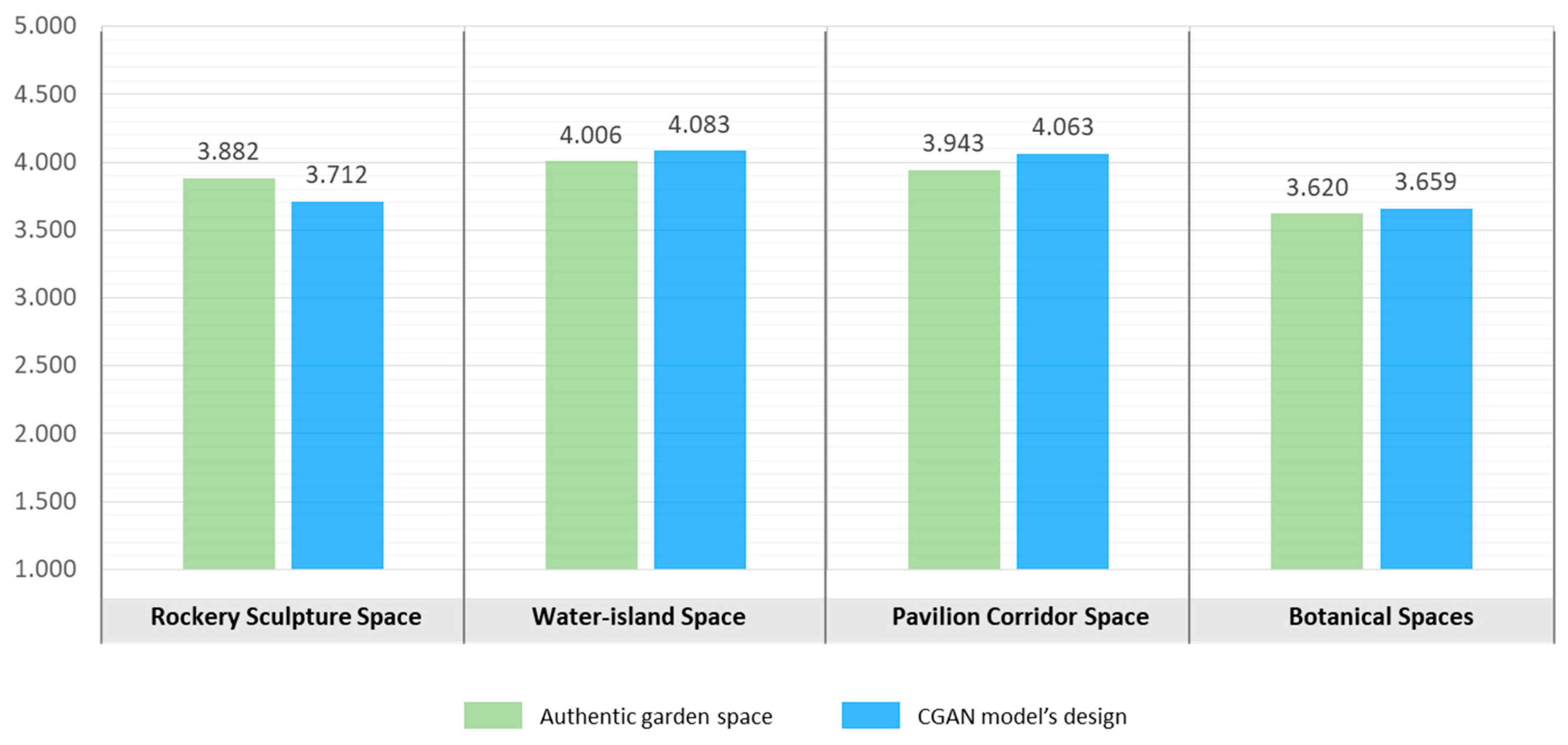
| Name of Shape Group | Source | Mean | Std. Deviation | No. of Items | |
|---|---|---|---|---|---|
| 1 | Rockery sculpture space | Authentic garden space | 3.882 | 1.007 | 306 |
| CGAN model’s design | 3.712 | 1.078 | 306 | ||
| 2 | Water-island space | Authentic garden space | 4.006 | 0.969 | 306 |
| CGAN model’s design | 4.083 | 0.943 | 306 | ||
| 3 | Pavilion corridor space | Authentic garden space | 3.943 | 0.974 | 306 |
| CGAN model’s design | 4.063 | 0.966 | 306 | ||
| 4 | Botanical spaces | Authentic garden space | 3.620 | 1.156 | 306 |
| CGAN model’s design | 3.659 | 1.132 | 306 |
Disclaimer/Publisher’s Note: The statements, opinions and data contained in all publications are solely those of the individual author(s) and contributor(s) and not of MDPI and/or the editor(s). MDPI and/or the editor(s) disclaim responsibility for any injury to people or property resulting from any ideas, methods, instructions or products referred to in the content. |
© 2025 by the authors. Licensee MDPI, Basel, Switzerland. This article is an open access article distributed under the terms and conditions of the Creative Commons Attribution (CC BY) license (https://creativecommons.org/licenses/by/4.0/).
Share and Cite
Yan, L.; Zheng, L.; Jia, X.; Zhang, Y.; Chen, Y. Machine Learning in the Design Decision-Making of Traditional Garden Space Renewal: A Case Study of the Classical Gardens of Jiangnan. Buildings 2025, 15, 2401. https://doi.org/10.3390/buildings15142401
Yan L, Zheng L, Jia X, Zhang Y, Chen Y. Machine Learning in the Design Decision-Making of Traditional Garden Space Renewal: A Case Study of the Classical Gardens of Jiangnan. Buildings. 2025; 15(14):2401. https://doi.org/10.3390/buildings15142401
Chicago/Turabian StyleYan, Lina, Liang Zheng, Xingkang Jia, Yi Zhang, and Yile Chen. 2025. "Machine Learning in the Design Decision-Making of Traditional Garden Space Renewal: A Case Study of the Classical Gardens of Jiangnan" Buildings 15, no. 14: 2401. https://doi.org/10.3390/buildings15142401
APA StyleYan, L., Zheng, L., Jia, X., Zhang, Y., & Chen, Y. (2025). Machine Learning in the Design Decision-Making of Traditional Garden Space Renewal: A Case Study of the Classical Gardens of Jiangnan. Buildings, 15(14), 2401. https://doi.org/10.3390/buildings15142401